village defenses of the karnataka maidan, ad 1600-1800
TRANSCRIPT

Village Defenses of the Karnataka Maidan, AD 1600-1800 BARRY LEWIS
I n t r o d u c t i o n
T h e Nayaka period in K a r n a t a k a roughly brackets the centuries between the fa l l of R a m a Raya ' s capital c i ty o f Vi jayanagara in 1565 and the fall of T i p u Sul tan 's capital of Sr i rangapatna in 1799. T h e former effectively broke the back of the Vi jayanagara empire in K a r n a t a k a and the latter left the Br i t i sh as the major poli t ical force in South India . ' In the turbulent centuries between these events, the Mughals , the Marathas , the Mysore sultans, the N i z a m , the B r i t i s h , the F rench , and scores o f smal le r rulers and chiefs fought for control o f much of South India . A s i f to make things worse, marauders roamed the countryside plundering what was left, and v i l lages preyed on each other when conditions grew par t icular ly hard.^
A s is general ly true of other eras of South Indian hi.story and archaeology, Nayaka period research is biased toward the rulers and other elite members of society, and toward major sites and events . ' C o m m o n people are .seldom more than shadows in the backgrounds of grander scenes. W h a t is s t r i k ing about this bias is that it exis ts in the face of evidence that Nayaka period common people often do have an a rch iva l presence, at least when v iewed at the v i l l age level.* S i m i l a r l y , archaeologists eve rywhere can study readi ly the material remains of a l l members of society. T h e inescapable inference is that relat ively little is k n o w n about the archaeology of precolonial sma l l communi t ies in South Ind ia more often becau.se of the prevai l ing priori t ies and interests o f modern society, his tor ians, and archaeologists rather than because of the lack of data.
M y objective here is to examine one aspect of the l ives of Nayaka period common people, that of v i l l age defense. Secur i ty concerns affect every v i l lager equal ly and the data needed to study this aspect o f v i l l age decis ionm a k i n g are readily available. Fur thermore , when v iewed across v i l l ages in the same region, defenses tend to v a r y less than many other factors. B y v i r tue of their nature, defenses respond more to external forces than to the internal socia l mi l i eu and history that contribute greatly to the divers i ty of India 's villages.^ T h e art icle 's ma in thesis is that the basic elements of precolonial v i l l age secur i ty cannot be
understood fu l ly unless considered in cu l tura l context as part of related larger issues of v i l l age design. A n d , i f one understands the basics of v i l l age design, the way is open to understanding aspects of Nayaka period town and c i ty design and how communi t ies general ly coped wi th the t ry ing conditions of these centuries.
Severa l other pract ical reasons also motivate the present focus on v i l l age defensive features. F i r s t ly , as wi th many other aspects of his tor ical research on the l ives of common people, studies of South Indian m i l i t a r y features and landscapes seldom address v i l lage- leve l .security concerns. ' ' T h e result promotes the unwarranted impression that defense was p r i m a r i l y the province of elites, and, i f it were widespread throughout society, it was of little consequence in the archaeological record of v i l l ages .
Secondly, although long-abandoned fortifications are common features of the modern Ind ian landscape, comparat ively little work has yet been done on their functional character is t ics . 'Notableexcept ions in South Ind ia include the work of Jean Deloche of the F rench Institute of Pondicherry;* the Vi jayanagara Research Project directed by John F r i t z , George M i c h e l l , and M . S. Nagaraja R a o ; ' and C a r i a Sinopol i and Ka th leen Morr i son ' s Vi jayanagara Metropoli tan Survey, wh ich centered on Vi jayanagara ' s immediate hinterland. '" O f par t icular s ignif icance in the latter research program is Rober t Brubaker ' s recently-completed P h D dissertation on late medieval and ear ly modern Vi jayanagara region fort if ications."
T h i r d l y , the defensive works of a l l communi t ies , even smal l v i l lages and hamlets, tend to be among the most massive features of the built environment . Becau.sc of these quali t ies (and also, in many cases, because of their lack of subsequent secondary uses except as raw mater ia l sources), the remains of v i l l age defenses have often su rv ived to the present and can be .studied archaeological ly. T h e s e features arc also among the few material aspects o f v i l l age life that frequently have an a rch iva l presence. G i v e n their relative obtrusiveness, they often stood out enough from their surroundings to attract the attention of contemporary observers who iet't wri t ten records. For example, F ranc i s Buchanan ' s narrat ive account of his tour of Mysore and
91

BARRY LEWIS
Uchchangipura /
;• \
- i. '••••'••->. ' „->^...
!\ Siddavvanadurga / <
' \=. ; -^Chitradurga^
•\
Bharmagtn Kurubarahalli
\ Pillajanahalli
/. Fonified village study area. Kaiiiataka, hi did. showing the locations of village sites mentioned in this article.
The next section describes the main dimensions of the defensive problem that precolonial Karnataka villagers had to solve and aspects of the region's physical and cultural geography that affected how they dealt with such issues. 1 then describe general features of a maidan village in Davangere district, which, while they were not necessarily shared by every village, were sufiiciently common to provide a useful heuristic. Next, I examine the heuristic's application to the study of village defen.ses and outline the assumptions that underlie its use. Given this comparative framework, representative small and large villages are described, based on archaeological field surveys in Chitradurga and Davangere districts. The final section identifies general patterns of village defense in the study region and discusses the extent to which villagers responded to ditferent security concerns, drew on different resources, and set different .security priorities to their rulers."
The Maidan region
Karnataka • Andhra Pradesh
i.'.3 CO.lf.l.-ll PIVKl:
•
\ Kerala
2. Fortified villages in centra! and southern Karnataka, 1799-1808.
Malabar between 1800 and 1801, immediately after the end of the Fourth Mysore War, mentions scores, if not hundreds, of fortified villages that he passed or visited.'- The most common attributes identified in Buchanan's village descriptions are the presence or absence of defensive features such as walls, towers, gateways, and ditches.
Finally, lest there be quibbles about their fimction and use, abundant evidence attests to the defensive nature of village features like tho.se examined here. The direct evidence includes contemporary eyewitness reports in Karnataka and the archaeological research on South Indian fortifications cited above (especially Brubaker's 2004 Vijayanagara fortification research)." Additional general support is provided by recent comparative research on fortifications and the archaeology of warfare.'"'
The study area includes parts of Chitradurga, Davangere, Bellary, Dharwar, Shimoga, Tumkur, and Chickmagalur districts in central Karnataka (Figure 1). It is mostly a .semi-arid scrub jungle plateau, which geographers call the Southern Maidan."^' To the west arc the forested mountains, or mainad, of the Western Ghats, through which narrow passes lead down to the low-lying, well-watered coastal plain bordering the Arabian Sea. To the east the transition from plateau to coast is more gradual through the Eastern Ghats to the Andhra Pradesh and Tamil Nadu coastal lowlands and the Bay of Bengal. The plateau continues to the north as the Southern Deccan. To the south, it ends in the Nilgiri Mountains.
Like all natural landscapes, this diverse region played an active role in the drama of human lives. The maidan, mainad, and coastal plains each offered different possibilities, constraints, and histories, all of which influenced community decision-making. Local surface relief, vegetation cover, soils, precipitation patterns, rivers, drainage, and even seasonal changes in climate are just some of the natural factors that villagers considered in decisions about the safety and well-being of iheir families and the community as a whole. In the mainad, for example, villages were often a web of spatially discrete households and neighborhoods spread across a relatively large area." In many such cases, village defense relied on the ruggedness of the terrain; on barriers and earthworks that defended roads and trails; and on the option of .scattering into the forest rather than seeking protection in fortified, nucleated settlements.
The situation was different in the maidan region, where the terrain offered a broad natural line of advance for armies. Much of it was good country for cavalry and it held abundant opportunities for robber bands. Here, villages were generally nucleated and some form of defensive works
92 Suiidi Asian .Snidies 2.5

V l L L A G I J DlEFIiNSES O l - T l l l i K A K N A T A K A M A I D A N , A D 1600-1 <S()()
were part of the basic fabric o f precolonial v i l l age design.' ' '
F igure 2 shows the distribution of fortified v i l lages in central
and southern K a r n a t a k a , as recorded by C o l i n Mackenz ie ' s
Mysore Survey between KSOO and hSOS.''' Based on a
conservat ive estimate derived from the symbology of the
Mysore S u r v e y maps, at least 253 of the 1<S,059 vi l lages
identified by the surveyors were fortified. '" O f the fortified
v i l lages , 212 ((S4%) were located in the inuidan region, 4 0
(16%) were in the malnad, and one was on the coast in what
is today D a k s h i n Kannada district . Even after one controls
for the different s izes of the maidan, malnad and coastal
regions, late Nayaka period maidan v i l lages were nearly
twice as l ike ly as malnad v i l lages to be fortified.
M a i d a n v i l l a g e des ign
T h i s study examines Ihe archaeological remains of v i l lages that were general ly too insignificant to warrant inclusion on nineteenth-century maps of South India. T h e concept of ' v i l l age ' , whether v iewed in Eng l i sh or Kannada , the common vernacular of the study region, is , at best, rather fuzzy.- ' For present purposes, a v i l lage is defined as a smal l communi ty of households in which religious, r i tual , and adminis t ra t ive services are p r imar i l y local in scope. F o l l o w i n g common E n g l i s h usage, v i l lages arc smal le r than towns and larger than hamlets.
T h e typical spatial layout of maidan v i l lages owes little to the guidelines given by traditional t ex t s , " or to the common stereotype of them as out-of-the-way, solf-sutficient communi t ies . - ' Nevertheless, the defensive aspects of v i l lage layout include some ofthe more patterned aspects of v i l lage plans because, as noted above, securi ty threats arc largely defined by external factors, not by forces internal to each vi l lage .
The Kallapura layout K . G . G u r u m u r t h y ' s ethnographic research at Kal lapura , -* the fictitious name he gave to a v i l lage in what is today southern Davangcrc distr ict , provides a useful general model wi th w h i c h to character ize Ihe basic defensive layout of maidan villages.-'^ Al though G u r u m u r t h y describes this pattern as a series of " r i tua l c i rc les" , the term ' layout ' is used here to emphasize the aspects of ri tual c i rc les that contribute to overal l v i l l age design, not merely its ri tual landscape. Unless otherwise indicated, the fol lowing paragraphs about the K a l l a p u r a layout are mostly a synthesis of G u r u m u r t h y ' s several accounts.
V i l l ages are protected by both physical and ritual barr iers that, taken together, defend the communi ty against bad people, ev i l spir i ts , diseases, i l l fortune, lessened ferti l i ty, and other factors that can d imin i sh the health, prosperity, securi ty, and general wel l -being of its inhabitants. T h e s e barriers form an integrated whole that influence how the v i l l age maps itself onto the ground and its spatial relationships wi th neighboring communi t ies . T h e
.)'. Kallapura village layoiil. as described by Guriiiniirrliy (cf. now 24).
extent of these barriers are defined and controlled by the
v i l l age , but, in modern vi l lages at least, they do not exceed
the revenue boundaries surveyed by the government.
E a c h v i l lage is divided into two parts, the urn, or v i l lage proper, and the adive, or the v i l lage ' s fields, pastuies, and fal low ground (F igu re 3). T h e core area of the nrn is the temple compound {gudi powli) o f the v i l l age deity.-'' T h e inner settlement {holal<eri) surrounds this compound and is the v i l lage ' s oldest residential area. It typ ica l ly comprises large, wel l-constructed houses associated wi th the or ig ina l settlers. Often, the homes ofthe headman and v i l l age priest w i l l be in the liolakeri. T h e outer settlement {horakeri)
contains the homes of or ig inal settler fami l ies and lower class v i l lagers ; many of these houses are smal ler and less well-bui l t than those of the holakeri. Beyond the outer settlement is the threshing ground (ola-kanagalu), wh ich was o r ig ina l ly a non-residential area that contained the threshing and w i n n o w i n g areas, as wel l as storage faci l i t ies for g ra in , firewood, and an imal fodder. A s a v i l lage grows, houses and streets encroach on this area. T h e threshing ground is ringed by the protecting fence (pahari heri),
often a thick bound-hedge open only where it intersects a road.- ' G u r u m u r t h y describes this fence as
the d iv id ing l ine between the residential and the non-residential area, between the members and the non-members, and between the l i v i n g and the dead members of the communi ty . It is left open only at the roads wh ich lead to the neighbouring
93

BARRY LEWIS
Non-defensive boundary Defensive boundary 4. Village defensive iavoiiis: A. Area-iype defense; B. Poinl-lype defense using a inide or rower.
villages. In the past there were gates {agase bagilu) to regulate the movement of men and materials. They were watched round the clock by the village watchman,^"
The protecting fence defended the village against human enemies, animal predators, evil spirits, the loss of fertility, and diseases; village rites ensured its ritual purity.
The adive lies between the protecting fence and the village's ritual boundary (Figure 3). Taken as a whole, the adive is not a residential area, nor is it ritually protected or pure. The village's ancestral fields (inanedolagalu) abut the protecting fence. These fields are among the most valued in the village and are the locus of several village rites and some of the ancestral tombs. The fields [Imla) that stretch beyond the ancestral fields are less valued, are often more difiicult of access, and have little ritual significance in village life. The village ritual boundary {lira gadi) surrounds the latter fields. Although infused with considerable importance as the village's outmost perimeter of ritual and economic activity, delimited by ritual boundary stones (niinidrekal.iu), and guarded by village deities who may be acknowledged by shrines erected at the parts of the boundary under their protection, it is established by village rituals alone and does not follow the village's revenue boundary. It does, however, lie within the latter boundary.^'
The rudlira bliumi (cemetery or cremation ground) (Figure 3), or the space between the ritual boundaries of
two adjacent villages, is noteworthy because it is ritually unclean. As the name implies, it serves as the burial and cremation ground for some classes of village residents. Within it live evil spirits, diseases, and ill fortune, all of which have been driven there by the village gods. Presumably, the boundary stones and markers that identify the revenue limits of the village fall in this space.
As community-centered as the Kallapura layout may be, Gurumurthy describes a mid-twentieth-century world that was more strongly focused on individual households than existed anywhere in the maidan region during the Nayaka period. Missing from the Kallapura layout are the stone and mud fortifications and ditches that were once the most obtrusive features of village layout. Like Kallapura's fort walls, which vanished over the past couple of centuries, this aspect of village design disappeared as the state imposed its authority across the region in the nineteenth century, dismantled the strongholds, and disbanded the private armies of the remaining poligars.'"
Village defenses Archaeological field survey in central Karnataka suggests that precolonial village defensive works other than bound-hedges commonly varied with the size of a given community and whether its inhabitants decided to defend a perimeter or a point. Most large villages and some small villages opted to defend a perimeter. They typically sited their main defenses between the inner and outer settlements (the holakeri and Iwrakeri respectively) (A in Figure 4). For
94 Souili Asian Suidies 25

V I L L A G E DEFENSES O F T H E K A R N A T A K A M A I D A N , A D 1 6 0 0 - 1 8 0 0
example, wr i t i ng about central and southern K a r n a t a k a in
the late nineteenth century, B . L e w i s R i c e observed.
Most important v i l lages and towns have a
considerable fbrt of mud or stone, also the
erection of former tioublous t imes, when
every gauda aimed at being a palegar, and
every palegar at becoming independent.
T h e fort is the quarter generally affected by
the B r a h m a n s , and contains the pr incipal
temple. T h e p e / e or market, wh ich invar iably
adjoins the fort at a greater or less distance
beyond the w a l l s , is the residence of the
other orders. ' '
Rather than attempt to defend the v i l lage as a whole, many smal ler communi t ies tended to defend a strategic point w i th in or adjacent to the holakeri ( B in F igure 4) . W r i t i n g about the study legion in the nineteenth century, R i c e noted that ' v i l l ages commonly have the remains of a round tower in the middle , a somewhat picturesque feature, erected in former days as a place of retreat for the woinen and chi ldren in case of attack'. '-
E v e n without the direct evidence of stone and mud fort w a l l s , G u r u m u r t h y ' s K a l l a p u r a layout concept is par t icular ly i-elevant to a discussion of v i l l age defense for several leasons. F i r s t ly , it identifies a logic and order of v i l l age design that goes beyond a s imple perspective of defense as a response only to anticipated human conflict . T h e K a l l a p u r a layout reminds us that v i l l age defense is inevitably more than wa l l s , gates, ditches, towers, and protecting oneself against other people. It is about protecting the v i l l age from the whole gamut of human, a n i m a l , and spir i tual forces that may act on its wel l -being. Cast in this light, it also shows clear ly that the material expressions of v i l l age defense must be examined both broadly and contextual ly i f they are to be understood in more than a superficial way.
Secondly, v iewed archaeological ly, v i l lages are more than spatial ly concentrated debris scatters o f the remains of houses, outbuildings, and public spaces. A v i l l age layout extends wel l beyond where the streets and houses end and the fields begin, and its spatial patterning can be infused wi th many layers of meaning that are significant in v i l l age l ife. Insofar as this is true, it follows that archaeological investigations of v i l l ages , especia l ly research that considers such problems as defense, must adopt a spatial perspective of v i l lages that is greater than their residential cores.
T h i r d l y , not a l l v i l l age boundary markers mean the same thing, nor do they figure prominent ly in a communi ty ' s defensive pr ior i t ies . ' ' Depending on the nature of local land tenure practices, v i l lage revenue boundaries may, for example, be important to landowners whose property includes land that l ies between the ritual
and revenue boundaries, but the v i l l age as a whole may not v iew such land in the same light as s i m i l a r property that l ies w i th in the ritual boundary or w i t h i n the protecting fence.
F i n a l l y , v i l l age (and c i ty) wa l l s are not necessar i ly the only defenses, but may be s imply the most vis ible component of a defense that incorporates other out lying elements, such as bound-hedges, that may be removed spatial ly from the v i l l age core and leave little trace in the archaeological record. V i e w e d str ict ly from a functional perspective, v i l l age wa l l s and bound-hedges could play s i m i l a r det'ensive roles. T h e y both created physical barr iers that channeled access through the v i l l age gates. T h e y also made (as v i l lagers undoubtedly hoped) the anticipated co.st of penetrating these barriers greater than some k inds of attackers were prepared to pay.
How can one use these ideas to facilitate the interpretation of precolonial v i l l age defenses? T h e y are probably best treated as heuris t ics , wi th wh ich one asks the question: what would precolonial defenses look l ike i f maidan v i l l age layouts were organized along the same general l ines as Ka l l apu ra? Wi th these expectations in mind , we can then turn to the archaeological record and assess from material remains and spatial relationships the extent to w h i c h a given v i l l age site was laid out according to s i m i l a r pr inciples .
Before considering real cases, several additional assumptions need to be made about v i l l age defense. F i r s t ly , v i l lages , whether ancient or modern, in India or elsewhere, do not attempt to defend against armies . V i l l a g e r s lack the means -weapons , t ra ining, manpower, leadership, and stores - to lesist ove rwhe lming force. V i l l a g e r s un lucky enough to find themselves in the path of an advancing a rmy or the object of a concerted attack by a large band of marauders tend to hide what they can and run away.'* For the latter v i l lagers , passive defenses such as gra in storage pits, or hagevii, hidden in and near the v i l l age , helped to protect a f ami ly ' s harvest from both agr icul tura l pests and robbers.'-^ However, even hagevii were not proof against loss. Fo r example, dur ing the T h i r d Mysore War, European soldiers witnessed both Maratha and Mysore marauders seeking out and robbing v i l l age hagevu as their respective a rmies advanced through the countryside." '
Secondly, defensive works are inherently reactive. T h e i r design reflects a vi l lage 's assessment ofthe l ikely forces that threaten its well-being and the anticipated strength, technology, and probable tactics of these forces. Insofar as this is true, fortifications say nearly as much about possible attackers as they do about the vi l lagers who erected them.
T h i r d l y , and related to the previous assumption, the scale o f v i l l age defensive works tends to be proportional to the s ize and weal th of the communi ty it defends. S i m p l y put, a weal thy c o m m u n i t y can afford a more robust defense than a poor one o f the same size, and may be more motivated to do so because it feels that it has more to lo.se i f the defense fa i ls .
95

BARRY LEWIS
Finally, .status display is seldom an issue in village defenses. Unlike the fortifications erected in the towns which were the headquarters of nayakas and poligars, villagers seldom attempted to incorporate status markers into their defensive works. For example, archaeological field survey in the study region suggests that village defensive works emphasized function over style consistently. To these villagers, the value of physical barriers rested more with perceived etficacy than adherence to a particular architectural vocabulary or style.
The next two sections apply the Kallapura heuristic to example sites drawn from the results of field surveys in Chitradurga and Davangere districts, Karnataka. The first section deals with small villages and compounds, the second with large villages.
Small villages and compounds
The most commonly-encountered archaeological remains of village defenses are those designed to protect communities against the real threats posed by other people. These aspects of the built environment tend to survive longer than other cultural features because they are typically the most massive and, consequently, the most obtrusive identifiable surface remains of the villages they were built to defend. Houses and outbuildings may disappear quickly, boundary stones be uprooted, and bound-hedges cut away, but fortifications, especially those built entirely or partly with stone, often endure simply because of their size and the fact that they have few, if any, secondary uses except as a source of raw materials. The choice of fortification building materials does matter, however, and the surface remains of mud-walled forts are often only identifiable today as ridges of earth that follow the trace of what were once proper walls. Few Nayaka period mud brick walls and buildings in the study region are as well-preserved as those at Chitradurga Fort, where coatings of chtinain (lime plaster) and the district's low average rainfall have preserved them."
This section considers the smallest precolonial village sites that show surface evidence of defensive works. The main challenge faced by the inhabitants of the.se villages was to devi.se a viable defen.se from limited resources. It has never been a trivial task to defend a small poor community. As the mid-nineteenth-century expert on fortifications Hector Straith remarked, the rule of thumb when designing a defense is 'small place, bad place', and for sound reasons.'" In many such communities, for example, what may seem to be the obvious solution of erecting mud or stone walls around the inner settlement of the village would have been utterly impractical because, even if the raw materials were readily available and affordable, there were too few villagers to construct, maintain, and defend the resulting large perimeter. The plight of the small village therefore compels us to identify that which was to
be defended, if one could not defend the whole, and then ascertain how villagers achieved this objective.
The object of a community defen.se takes many forms and varies according to cultural traditions, historical contexts, and what villagers agree to defend against. One could choose to defend some or all of a village's inhabitants, village places or neighborhoods of particular significance, historically- or ritually-defined perimeters, and so on. As noted above, a village's defensive pose is also a function of the inhabitants' assumptions about the nature, tactics, and means of potential threats. A disciplined army thought to be dragging a train of artillery would have been viewed quite difl'erently by villagers to a small band of marauders mounted on country ponies and armed with swords, spears, and the odd rusty matchlock.
Next to simply running away (a viable defensive strategy for the inhabitants of many small communities), the Kallapura layout conferred on its inhabitants a certain amount of protection - both real and ritual - without further elaboration. In particular, the protecting fence, or bound-hedge, defined a cheap yet eft'ective perimeter. For some villages it was in fact the primary defensive feature. A dense protective fence of thorn bushes required attackers to concentrate their force at particular points, whether to cut through the fence or to contest the gates where the fence intersected roads. The main drawback of the protecting fence was that once penetrated, it could become a defensive liability if it constrained the villagers' ability lo concentrate force or flee. Nevertheless, Arthur Wellesley, the future Duke of Wellington, found bound-hedges to be .serviceable protection for many villages during the Third Mysore War.''' Similarly, Tipu Sultan's regulations required that existing village and town hedges be maintained and new ones planted where they were needed.'"'
Pillajanahalli Moving beyond the protecting fence, which, to date at least, is effectively invisible archaeologically, to the habitation area of villages, the siinplest niaidan defense did not attempt to secure the entire community, but concentrated resources on defending a point, typically using a tower or hude built in or near the village ( B in Figure 4). Kittel describes the hude as "a circular bastion-like structure of stones, etc. at some distance from a village in which peasants endeavoured lo secure themselves in the time of a sudden attack from marauders'.'" Francis Buchanan, traveling through Kolar district in May of ISOO, described one of the many varieties of hude:
A l l the houses are collected in villages, and the smallest village, of five or six houses, is fortified. The defense of such a village consists of a round stone wall, perhaps forty feet in diameter, and six feet high. On top of this is a parapet of mud, with a door in
96 South Asian Studies 25

V I L L A G E DEFENSES O F T H E K A R N A T A K A M A I D A N , A D 1 6 0 0 - 1 8 0 0
i i , 10 wh ich access is by a hiddcr. In case of a plundering party coming near the v i l lage , the people ascend into this tower, wi th their fami l ies , and most valuable etfects, and having d rawn up the ladder defend themselves wi th stones, w h i c h even the women throw wi th great force and dexlerity."'-
R i c e further notes that, i n the distr icts ly ing north-east from the Baba Budans | i .e . the present study area], v i l lages common ly have the remains of a round tower in the middle, a somewhat picturesque feature, erected in former days as a place of retreat for the women and chi ldren in case of attack'."" T h a t hude were often, i f not usually, considerably tal ler than the K o l a r distr ict v i l l age example quoted above is i l lustrated by Campbe l l ' s remark about Bi japur distr ict v i l lages : "From a distance the first parts of a v i l l age that catch the eye are the trees and the v i l l age tower'.*'*' T h e same can be said of the hude ruins that s t i l l su rv ive in the study a iea .
C h i t r a d i i r g a and Davangere d i s t r i c t s conta in the a rchaeo log ica l r ema ins of severa l types of hude-
based v i l l a g e defenses, a l l of w h i c h , l i k e the Sco t t i sh dun or broch that they supe r f i c i a l l y resemble, are set in gently ro l l i ng t e r ra in that offers few natura l defensive advantages.*" One of the s imples t example s i,s P i l l a j a n a h a l l i , w h i c h l ies severa l k i l ome te r s south of the Vedava t i R i v e r in H i r i y u r t a luk , C h i t r a d u r g a d i s t r i c t ( F i g u r e 1 ) . No in sc r ip t ions or other dated r ema ins are assoc ia ted w i t h th is site, w h i c h is in fe r red to be a N a y a k a per iod locat ion based on in format ion rece ived f rom loca l v i l l a g e r s and the s i m i l a r i t y of its cons t ruc t ion methods and mate r i a l s to documented N a y a k a per iod sites e l sewhere in the study region.
T h e only s u r v i v i n g P i l l a j a n a h a l l i s t ructure is the hude i t se l f ( F i g u r e 5 ) , w h i c h stands out so much from the sur rounding fields that the d is t r ic t map marks the site w i t h a fort symbol.*"' T h e hude measures eleven meters in diameter and its much-reduced w a l l s are approximate ly five to seven meters high. It consis ts o f a c i r c u l a r two-faced slab-and-rubble w a l l , measur ing about 1.6 meters th ick , w h i c h was filled in wi th ear th and stones to make a sol id platform. Nothing remains of its o r ig ina l top, and it cannot be determined i f a stone or mud parapet and door once c rowned the P i l l a j a n a h a l l i s t ructure.
97

BARRY LEWIS
Later construction
6. Kiin(haralialli sile plan.
The weeds, brush, and other ground cover around the Pillajanahalli hude make it hard to identify more than a few major surface features, even during the dry season, and it is unknown if the hude was constructed within the village's residential area or nearby. Inspection of the overgrown field in which the hude sits revealed traces of a 1.5 to 1.7 meter-wide two-faced rubble wall that may have once enclosed it.
The point-based objective of a /H(f/e-centered village defense worked best, or perhaps only worked at all , i f one's attackers were simply marauders for whom success was a quick raid with opportunities for looting or cattle lifting. In the face of a more sustained attack, the hude must have been of little defensive value.
Kurubarahalli The /lurfe-centered defense was not the only option open to small communities. Given sufficient resources and a small area to protect, they sometimes elected to defend the living area itself. The Kurubarahalli site is the remains of a walled compound with corner towers (Figure 6) set on a stony level plain about one kilometer north of the Vedavati River in Hiriyur taluk, Chitradurga district (Figure I ) . The site does not have a local name, so it is referred to here by the name of the closest village, Kurubarahalli, which is situated about two kilometers to the southwest."' Like Pillajanahalli, it is identified as a late precolonial site based on its .stylistic similarities with documented Nayaka period sites in the region.
Given the ab.sence of visible habitation remains in the fields around the site, its size (1876 meters .square), and its interior features, Kurubarahalli appears to have been an isolated large household of means, possibly the fortified compound of a wealthy farmer or local poligar, The compound and its adjacent fields may well have been surrounded by a bound-hedge, but surface traces of any such natural defen.ses vanished long ago.
The two-faced compound wall measures about 1.3 meters wide and is made of dry-laid rubble and lenticular slabs, each of which are roughly 25 to 50 centimeters long and 20 to 35 centimeters thick. It is not banked or revetted on the interior by earth or rubble. The same general wall construction style persists in local village hou.se walls to this day. The only identifiable gateway is about midway along the south wall , where there is a three meter-wide gap in the rubble, flanked on the interior by the foundations of what appear to have been small guard rooms (Figure 6). As originally constructed, the compound walls lacked corner towers. Taken by themselves, these walls would have provided relatively little security, even if their outer faces were piled with cut thorn bushes, a practice that is also still common in the region. The wall is too eroded to ascertain if it had been finished with loopholes and the like. The corner towers, which were added to the compound walls in a later construction stage, may well have been the main defense points, as they enfilade the walls completely.
The remains of a large ruined building and courtyard take up about one third of the compound interior. It was built in the same general manner as the compound walls and towers. Additional structural remains may be present inside the compound, but they cannot be delineated clearly in the rubble and thorn bushes that cover the site.
Sometime subsequent to the construction of the compound walls, a rectangular structure of dry-laid rubble and lenticular slabs was built against the exterior of the south wall (Figure 6). The slabs of this structure are roughly 25 to 50 centimeters long and 5 to 10 centimeters thick; they are noticeably thinner than the slabs used in the compound walls. Several nagakal, or snake stones, rest against the base of the north wall of this collapsed structure.'"*
In summary, Pillajanahalli and Kurubarahalli offer different material expressions of defensive measures taken by the smallest maidan villages or hamlets and represent site types that are archaeologically unknown in South India. The Pillajanahalli villagers chose to defend a point, the hude, while Kurubarahalli defended a small area, possibly comprising a single isolated household. Both types also may have incorporated natural defensive features such as bound-hedges into their overall plan, which would have helped to mitigate some of the defensive challenges of the flat to gently rolling terrain on which they were built.
Large villages
The variety of defensive poses increases with village size, but in a complex way that is more aptly described as the expression of an interrelated web of factors than links in a chain. In the maidan region, for example, isolated hills or clurrips of hills provided naturally strong defensive features, especially when they were also well-watered and near major lines of communication.'*'' Over the centuries, many such maidan locations became the sites of cities.
98 South Asian Snidies 25
V I L L A G E DEFENSES O F T H E K A R N A T A K A M A I D A N , A D 1600-1800
towns, or v i l lages . Nevertheless, natural defensive quali t ies
alone cannot account for the spatial distribution of Nayaka
period v i l lages and towns or for the ways in wh ich h i l l s
were integrated into v i l l age layouts.
T h e fo l lowing three examples il lustrate the
diversi ty of defensive poses of maidan v i l l ages larger than
P i l l a j anaha l l i and K u r u b a r a h a l l i . T w o of these v i l lages ,
B h a r m a g i r i and Siddavvanadurga , incorporated isolated
h i l l s in their designs. Both v i l lages also included an inner
core or citadel that served as the ultimate l ine of defense.
T h e remain ing v i l l age , Uchchangipura , erected the most
substantial defensive works of the v i l lages considered here,
but, instead of a ci tadel , its ult imate defensive feature was a
liude placed inside the fort wa l l s .
NOTE: Tho con!our-iike lines are intended io give a sense of the terrain and are no! !0 scaie
Village' Area
- J.,.:: Approximate locations of destroyed walls
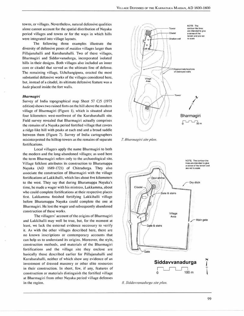
Bharmagiri S u r v e y of India topographical map Sheet 57 C/5 (1975 edition) shows two ruined forts on the h i l l above the modern v i l l age of B h a r m a g i r i (F igu re 1), which is situated about four ki lometers west-northwest of the Kuruba raha l l i site. F ie ld survey revealed that B h a r m a g i r i ac tual ly comprises the remains of a Nayaka period fortified v i l l age that covers a r idge-l ike h i l l wi th peaks at each end and a broad saddle between them (F igu re 7) . S u r v e y of India cartographers misinterpreted the hi l l top towei's as the remains of separate fortifications.
L o c a l v i l lagers apply the name B h a r m a g i r i to both the modern and the long-abandoned vi l lages; as used here the term B h a r m a g i r i refers only to the archaeological site. V i l l a g e folklore attributes its construction to Bharamappa Nayaka ( A D 1689-1721) of Chi t radurga . T h e y also associate the construction of B h a r m a g i r i wi th the v i l l age fortifications at L a k k i h a l l i , w h i c h lies about five ki lometers to the west. T h e y say that dur ing Bharamappa Nayaka 's t ime, he made a wager wi th his mistress, L a k k a m m a , about who could complete fortifications at their respective places first. L a k k a m m a finished for t i fying L a k k i h a l l i v i l l age before Bharamappa Nayaka could complete the one at B h a r m a g i r i . He lost the wager and subsequently abandoned construct ion of these works .
T h e v i l l a g e r s ' account o f the or ig ins of B h a r m a g i r i and L a k k i h a l l i may w e l l be true, but, for the moment at least, we lack the ex terna l evidence necessary to ve r i fy it. A s w i th the other v i l l ages descr ibed here, there are no k n o w n inscr ip t ions or contemporary accounts that can help us to understand its o r ig ins . Moreover , the s tyle , const ruct ion methods, and mater ia ls o f the B h a r m a g i r i fort if ications and the v i l l age site they enclose are bas ica l ly those descr ibed ear l ie r for P i l l a j a n a h a l l i and K u r u b a r a h a l l i , neither of w h i c h show any evidence of an investment of dressed masonry or other elite resources in their const ruct ion. In short , few, i f any, features of cons t ruc t ion or mater ia l s d is t inguish the fortified v i l l a g e at B h a r m a g i r i from other N a y a k a period v i l l age defenses in the region.
Bharmagiri
0
7. Bliarriiagiri sue pi air
NOTE; Ttte contour-lil^e lines are intended to give a sense of the terrain and are not to scafe
- Dry dilcin
Main c
'Ga te
Siddavvanadurga j
100 m
8. Sldclavvaiiaclarga sue plan.
99

BARRY LEWIS
Local villagers say they lived within Bharmagiri's walls until the 1950s, when (hey moved off the hill to be closer to the modern road and a better water supply. Abundant evidence of two-faced rubble walls, block mortars, potsherds, and other cultural debris on the saddle area of the hill provide convincing evidence that the village thrived there for many generations. Although the general condition of the old village is poor, mostly because it has been scavenged for building materials, the move had a generally positive impact on site preservation. The site now appears to seldom be visited except by shepherds and little boys from the village below.
Bharmagiri's basic design concept was to fortify the hill's opposing elevations with square towers, both of which offer commanding views for several kilometers, and erect the village on the saddle between them (Figure 7). Walls built along the saddle crest connected the two towers and completed the village enclosure. It was a good plan, but it would have been a better one if the hill had had an adequate water supply. The lack of water on the hill undoubtedly hindered any sustained defense of the village.
The walls and towers are dry laid courses of lenticular slabs and rubble like those found at Kurubarahalli. The village walls that once connected the hilltops can be traced on the ground surface by following the line of one or two stone courses. The rest of the walls have fallen down, eroded away, or been robbed of their stones. The towers are the best preserved portions of the fortifications with walls that measure 1.5 to 3 meters high. The northern hill differs from the southern one in that its tower also covers an area of roughly 740 meters square, which appears to have been a small citadel. The single remaining standing building at Bharmagiri is a small (3.1 by 4 meter) abandoned masonry structure, possibly a former shrine of the village deity, in the citadel.
No gateways can be identified from surface evidence in the wall line that connects the two towers. The citadel on the north hilltop has a 2.3 meter-wide entryway placed in the middle of its south wall; this gate controlled movement between the citadel and the village center.
The only identified water storage feature is inside the citadel, where a 3.S by 3.1 meter natural depression was built up on one side with rock slabs and sealed with chiinam to create a small well.
Bharmagiri was not surrounded by a ditch, nor would one have contributed materially to the defense of the hill.
Even with its natural advantage of elevation, Bharmagiri may well originally have been surrounded by a bound-hedge planted at some distance from the foot of the hill. Such a feature would seem to have been essential to protect the threshing grounds, storage facilities, animal pens, and other parts of the village for which there was no room on the hill's saddle. Systematic survey of the surrounding locality needs to be undertaken to identify how the villagers dealt with this aspect of the design.
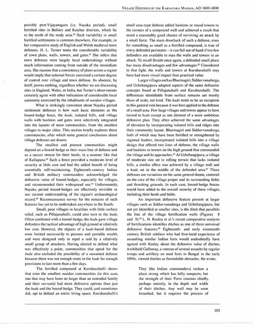
Siddavvanadurga Hills were also incorporated into village layouts as one component, generally the citadel, of a larger plan. For example, the remains of the old village at Siddavvanadurga cover an isolated hill and adjacent area of a gently rolling plain of red soil and boulders about fourteen kilometers northwest of the city of Chitradurga (Figure 1). The southern edge of the village walls lies within 100 meters of the present Siddavvanadurga, which straddles the paved road connecting National Highway 4 and the town of Jagalur. About 40 years ago, the village moved to its present site from inside the fort walls to have more room for growth and to be closer to a newly constructed main road.
According to local villagers, the old fortified village was built by Madakari Nayaka (of which there were four Chitradurga rulers with this name) in honor of his wife, Siddavva. Given the village's location on one of the major early nineteenth-century roads that crossed this region, it may also have played a role in the collection of customs duties or sayar on goods.'"
The core of the village layout was the small fortified hill that formed the citadel (Figure <S). The villagers say that this part of the fortifications once had five towers, the locations of two of which can no longer be identified. Two rounded towers are present on the eastern side of the citadel facing the main village area and a much larger circular tower dominates the highest point in the village at the north end of the citadel. The living area proper was concentrated at the foot of this hill to the east, which is also the side where the old main road passed the village.
Most of the outer fortification walls stand less than a meter high today, especially on the south side of the site, which is closest to the present village. No evidence of towers or other defensive features could be identified in the outer wall line. As with other abandoned village and town fortifications in the region, the walls continue to provide the modern village with a convenient source of building materials. The wall remnants around the village proper are more accurately described as earth ridges than walls except on the northern side where a two-faced rubble wall can be clearly traced up the hill . The presence of these earth ridges suggests that the eastern and southern Siddavvanadurga walls were mostly mud rather than stone.
The citadel and western village walls, on the other hand, are granite blocks and boulders laid in dry courses and chinked with small stones. The blocks used to build the large circular tower at the north end of the citadel share a more consistent shape than do the blocks and boulders of the fortification lines. This may reflect two distinct construction episodes at the site, the most recent of which was the addition of the towers in the citadel."
No gateways are now recognizable in the outer fort line, but the scattered remains of the southwestern corner of the fort may include such a feature in the area marked 'Gate?' in Figure iS. When asked about such features.
100 Sutiili Asian Snulies 25

V I L L A G E DEFENSES O F T H E K A R N A T A K A M A I D A N , A D 1 6 0 0 - 1 8 0 0
Granite boulders
9. ilchchaitgipiira site plan.
Siddavvanadi i iga v i l lagers pointed out the main gate's approximate location in the midpoint of the eastern w a l l l ine . T h e v i l lagers say that the gateway was about three meters wide, wi th dressed stone p i l la rs and bronze shutters. It opened direct ly onto what was then the ma in north-south road, now a mere cart track, and did not have a bent or covered approach.
T h e inner or citadel fortification l ine has two gates. T w o large boulders in the southern citadel w a l l define a 3 . 6
meter-wide gateway that leads down a s ta i rway of dressed granite slabs to a sma l l protected area in the southwestern corner of the v i l lage . T h e other citadel gateway passed through the eastern citadel w a l l and led down granite slab stairs to the northern part of the main v i l l age area.
T h e lemains of a 1 0 to 1 5 meter-wide ditch can be traced along the outside of the northeastern and eastern v i l lage wal l s (F igure S). It could not be determined from surface evidence whether the ditch continued along the south fort w a l l . T h e northwestern and western fort wa l l s rest on the granite sheet-rock of the h i l l and a ditch was apparently deemed impractical or unnecessary on these sides.
T h e c i r cu la r tower at the northern end of the citadel is the most v i sua l ly prominent part o f the site. T h i s tower was c rowned by a low masonry w a l l pierced by regularly-spaced loopholes. Today, the top of the tower also holds a chewwakesar'i (Deloiiix species) tree and a smal l ( 2 . 6 5
by 2 . 6 0 meter) modern shr ine dedicated to the v i l l age de i ty ." T h e shr ine 's wa l l s and roof are dressed rectangular granite slabs. Its narrow doorway faces east. T h e remains of only one other structure, a large rectangular bui lding of unknown age or use, can be traced in the citadel. Many w a l l a l ignments that mark the Ibundations of old buildings are vis ible in the v i l l age area proper (designated as ' V i l l a g e A r e a ' in F igure <S).
Wel l s and water storage faci l i t ies are noticeably absent from the vis ible surface features, but this may mean little as the site local i ty appears to be relatively wel l watered.
In summary , Siddavvanadurga was about twice the size of B h a r m a g i r i , but its core def'ended area represents a variat ion on the general theme of incorporat ing a smal l isolated h i l l into the basic fabric of v i l l age layout and its anticipated defense. A s wi th modern vi l lages in the distr ict , v i l l age design sought to adapt i tself to the local natural landscape rather than reshape it.
Uchchangipura T h e final example, ca l led Uchchangipura , occupies a low h i l l just west ofthe v i l l age ofthe same name in Jagalur taluk, Davangcrc distr ict (F igu re 1). It derives its name from the v i l lage goddess, Uchchang iye l l amma, whose ancient shr ine lies immediate ly to the west of the northwestern corner of the fortified v i l lage . L i k e the other v i l lages described
101

BARRY LEWIS
in ihis section, Uciichangipiira was occupied until a few generations ago, when the villagers moved their homes to a bare ridge near the tank that lies to the south. Later, after the construction of the paved road that passes the eastern side of the village, the village moved again to its present site just east of the old fortified village. The latter is now virtually abandoned and serves only as a source of building stones. That the villagers have not entirely forgotten ties to their ancestral home is evidenced by the fact that the ea.stern face of the village walls, the side that faces the modern village, still looks relatively untouched. Another generation or two of wall-robbing from the rest of the old village walls wil l reduce the site to an east-facing fajade.
The basic plan of the old village is that of a rectangular fortification with extensions to the east and west (Figure 9). Although the lower courses of walls can be traced throughout the enclosed area of roughly 1.4 hectares, surface features are poorly preserved. A large natural well, which now holds little water during the dry season, is also enclosed by a fortification wall extension to the south. The latter looks like a later addition; it is the only place where the village walls extend to two lines.
There are two main gateways, both of the bent entrance type, one about mid-wall on the north side of the village, the other about mid-wall on the south. The poorly dressed granite pillars and lintel of the south gate are still standing, but the rest of this gate and the walls that abutted it were pulled down long ago. No gateway access could be identified for the fortified natural well, but most of the walls in this part of the site have been robbed of their stones and the remains of a gateway could easily lie hidden among the dirt and rubble ridges that now mark the wall lines.
A hude placed near the village center is the only standing structure within its walls. It measures 15.9 meters in diameter at its base and stands 6 to 9 meters tall. The upper courses of the dry laid masonry of this tower and the bastions on the fort walls are pierced with loopholes at regular intervals." As at Bharmagiri and Siddavvanadurga, the fort walls are narrow and may have lacked parapets. Such narrow ramparts may have been of little service in an active defense other than to facilitate communication between the bastions." The latter were often the main fighting platforms. Both the walls and the bastions of South Indian forts often had tiled or thatched roofs.'''
The fragmentary basements of two temples, dedicated to Durga and Hanuman respectively, are situated inside the south gate (Figure 9). Local men report that, after the village moved to its present location, both temples were dismantled and reassembled outside the old village walls. The Durga temple is now close to the southeastern corner of the fortification; the Hanuman temple stands inside the modern village.
A ditch surrounds the village walls everywhere except immediately outside of the northern and southern gates. It measures about three meters deep and ten meters
wide. The fill from the ditch was piled to either side of the excavation, forming two low parallel ridges around the site.
On the west side of the old village, between the dry ditchand the fort wall, is the east-facing Uchchangiyellamma shrine (Figure 9), which is still in worship and considered by the villagers to be an integral part of the community. This shrine, the villagers claim, existed at its present location before the walls were erected, and it was the wish of the deity that the shrine would remain in its present, quite unusual location between the enceinte and the ditch.
In summary, Uchchangipura oft'ers an excellent example with which to end this survey of fortified villages because its defenses combine point- and area-type features found in other large villages, as well as in several towns across the study area. As a case in point, consider Colin Mackenzie's description of Holalkcrc, a pargana headquarters town in what is now western Chitradurga district, which Mackenzie visited on 20 July 1801."' It was '...large, surrounded by a wall faced with stone with several narrow but high turrets in the country fashion, of no strength: no guns - it has a dry ditch; two gateways; one large circular stone tower (or bruge) in the centre - it is populous and crowded with houses, being the cusbah or capital...'. Significantly, however, the fundamental design of Uchchangipura and Holalkcrc difl'er little from that which is typical of smaller communities such as Pillajanahalli and Kurubarahalli.
Discussion and conclusion
The main constraints of maidan village defenses were available manpower, wealth, building materials, local terrain characteristics, and villagers' assessments of the forces against which they could reasonably expect to defend themselves.''' Mud, rubble, and stone were the primary building materials. Wood was not used in the construction of fortifications, as it is a scarce resource throughout much of the study area. Most stone for hude and village walls was quarried locally, and average block size, the degree to which blocks have a regular shape, and the extent to which chinking was used in walls appear to be largely a function of the natural properties of the available stone.'" Wall bastions can be semi-circular or rectangular in plan, sometimes in the same fortification (e.g. Rantdurga, near Nayakanahatti in Chitradurga district).''^ Although gates were occasionally protected by bent or covered entrances, the passageways were low and narrow by comparison with the gates of major towns such as Chitradurga, Kannakuppe, Hosadurga, or Molakamuru. As a rough rule of thumb, two people walking abreast, perhaps even a bullock cart, could pass through a village gate, but a caparisoned elephant and its niahout could pass through the main gates of a major town.
Nayaka period maidan village fortifications also show considerable variability in their plans. Brubaker notes a similar lack of consistency in the plans of several
102 Souih Asian Snulies 25
V I L L A G E DEFENSES O F T H E K A R N A T A K A M A I D A N , A D 1 6 0 0 - 1 8 0 0
possibly post-Vijayanagaia (i.e. Nayaka period), sma l l fortified sites in B e l l a r y and Ra ich i i r dis t r ic ts , wh ich lie to the north of the study area.''" Such va r iab i l i ty in smal l fortified settlements is common elsewhere. For example, in her comparat ive study of E n g l i s h and Welsh medieval town defenses, H . L . Turne r notes the considerable va r i ab i l i t y of town plans, w a l l s , towers, and gates.''' She infers that town defenses were largely local undertakings without much information coming from outside of the immediate area. She reasons that a consistency of plans across a region would imply that external forces exercised a cer ta in degree of control over v i l l age and town defense. Its absence, by itself, proves nothing, regardless whether we are discuss ing sites in Eng land , Wales , or India , but Turner ' s observations cer ta in ly agree wi th other indications of considerable local autonomy exercised by the inhabitants of maidan v i l lages .
Wha t is .strikingly consistent about Nayaka period settlement defenses is how such basic elements as the bound-hedge fence, the liude, isolated h i l l s , and v i l l age w a l l s wi th bastions and gates were selectively integrated into the layouts of most communi t ies , from the smallest v i l lages to major ci t ies. T h i s section briefly explores these consistencies, al'ter which some general conclusions about v i l l age defenses are d rawn.
T h e smallest and pooiest communi t ies might depend on a bound-hedge as their main l ine of det'ense and as a secure retreat for their herds, in a manner l ike that of Kallapura. ' '^ Such a fence provided a moderate level of secur i ty at little cost and had the added benefit of being essential ly self-maintaining. Eighteenth-century Indian and B r i t i s h mi l i t a ry commanders acknowledged the defensive value of bound-hedges, especia l ly for v i l lages , and recommended their widespread use.''' Unfortunately, Nayaka period bound-hedges are efl'ectively invis ible in our current understanding of the legion's archaeological record.'"' Reconnaissance survey tbr the remains of such features has yet to be undertaken anywhere in the South.
S m a l l , poor v i l lages in locali t ies wi th little surface relief, such as P i l l a j anaha l l i , could also turn to the liude.
Often combined wi th a bound-hedge, the hude gave v i l l age defenders the tactical advantage of high ground at relatively low cost. However, the objects of a /!j(f/e-based defense were l imi ted necessar i ly to persons and portable wealth, and were designed only to repel a raid by a relatively smal l group of attackers. H a v i n g elected to defend what was effectively a point, communi t ies that opted for the hude also excluded the possibi l i ty of a sustained defense because there was not enough room in the hude for enough provis ions to last more than a few days.
T h e fortified compound at Kuruba raha l l i shows that even the smallest maidan communi t ies ( in this case, one that may have been no larger than an extended t'amily and their servants) had more defensive options than just the hude and the bound-hedge. T h e y could, and sometimes did, opt to defend an entire l i v i n g space. Kuruba raha l l i ' s
smal l a iea- type defense added ba.stions or round towers to the corners of a compound w a l l and achieved a result that stood a reasonably good chance of s u r v i v i n g an attack by a smal l force. T h e main drawback of such a defense, even for something as smal l as a fortified compound, is true of every defended perimeter - it can fa i l out of hand i f too few defenders are avai lable to man the wa l l s and towers in an attack. To recal l Strai th once again, a defended smal l place has many disadvantages and f'ew advantages.""-^ Considered in that light, the w a l l s and towers at K u r u b a r a h a l l i may have had more v isua l impact than practical value.
Larger vi l lages such as B h a r m a g i r i , Siddavvanadurga, and Uchchangipura adapted aspects of the same defensive concepts found at P i l l a janaha l l i and Kuruba raha l l i . T h e differences identifiable from surface remains are mostly those of scale, not k ind . T h e hude tends to be an exception to this general rule because it was best applied to the defense of a smal l area. F e w large vi l lages and towns appear to have turned to hude except as one element of a more ambitious defensive plan. T h e y often achieved the same advantages of elevation by incorporating isolated h i l l s and ridges into their communi ty layout. B h a r m a g i r i and Siddavvanadurga, both of wh ich may have been fortified or strengthened by regional leaders, incorporated isolated h i l l s into a v i l lage design that offered two l ines of defense, the v i l lage wa l l s and bastions or towers on the high ground that commanded the v i l lage and its approaches.''' ' A t Uchchangipura , a v i l lage of moderate size .set in rol l ing terrain that lacks isolated h i l l s , a s imi l a r efl'ect was achieved by a v i l lage w a l l and a hude set in the middle of the def'ended area.'''' T h e s e defen.ses are variat ions on the same general theme, centered on the core o f the vi l lage proper and its surrounding fields and threshing grounds. In each case, bound-hedge fences would have added to the overal l securi ty of these vi l lages , including their herds and fields.
A n important defensive feature present at larger v i l lages such as Siddavvanadurga and Uchchangipura , but not yet identified at smal ler sites, is the ditch that paral lels the l ine of the v i l l age fortification w a l l s (F igures 8 and 9).''** L . H . Keeley et al. 's recent comparat ive analys is of fortifications identifies ditches as one of three universa l defensive features.'^^' Eighteenth- and early nineteenth-century Br i t i sh soldiers who had first-hand experience of assault ing s i m i l a r Indian forts would undoubtedly have agreed wi th Keeley about the defensive value of ditches. Arch iba ld Ga l loway , a veteran of several assaults by regular troops and a r t i l l e ry on mud forts in Bengal in the early 1800s, v iewed ditches as formidable obstacles. He wrote.
T h e y |the Indian commanders i reckon a place strong which has lofty ramparts; but the strength of their Forts consists chiefly, perhaps entirely, in the depth and width of their ditches. A n y w a l l may be soon breached, but it requires the process of
103

BARRY LEWIS
10. Bangalore Fori, I79J (J. W. For/escne, A Hislory of the British Army, 2nd edn (London: Macniillan, 191 J), lU, pi. 10, lop).
a regular siege lo etfeci with a certainly of success a passage of troops accross a formidable ditch.'"
The final applications of the interpretive utility of the Kallapura model of village layout place it in comparative perspective with village defenses in the mountainous mainad region of the Western Ghats and with maidan cities.
It should be noted that Mainad villages are archaeologically as little known as their maidan contemporaries. Nevertheless, based on eighteenth- and early nineteenth-century accounts, it is clear that the logic and material expression of mainad village defenses differed fundamentally from the Kallapura model and the example maidan sites. Most of these differences can ultimately be attributed to terrain characteristics. Mainad villages tended to be dispersed collections of neighborhoods that often depended on their relative isolation and the rugged terrain on which they lived forsecurity." Community defense often took place away from the village, not around it. Taking advantage of the malnad's natural defensive strengths, most villages elected not to defend the village proper, but the lines of communication that led to it. Apparently the inhabitants of these communities reasoned that if an attacking force cannot reach your village, then it cannot harm it. Consequently the passes, roads, and trails of the mainad were defended in depth by trenches, earthworks, barriers, and breastworks collectively called kadangas, while the communities to which these lines led might be essentially undefended.'^
The main point is that/na/z/cic/village defense focused on the communication 1 ines, not the villages themselves, in a defense approach that differed strongly from that of maidan villages. The mainad pattern also reinforces my thesis
that investigations of prccolonial village security need to be rooted firmly in local cultural context. Archaeologists would be hard put to discover mainad village sites that appear as groups of spatially clustered households. Those that are found through site reconnaissance survey would likely appear to be undefended simply because the defenses were off-site along the community's trails and roads, not clustered around the village proper.
Although the Kallapura model clearly offers little insight into the defensive strategies of mainad villages, one can identify elements of it in the largest Nayaka period maidan towns and cities readily. Perhaps the best known examples of this point are the late eighteenth-century defensive works of Bangalore and Srirangapatna. The core of Bangalore's defenses was a masonry fort that covered the city walls, both of which were also protected by ditches (Figure 10). The outermost perimeter, however, was a bound-hedge that surrounded the city in a radius of roughly 5.5 kilometers from Bangalore Fort (Figure 11). This line of works enclosed an area of approximately 95 kilometers square and was cut by at least six major gateways on the main roads. Few details are available about the land-use patterns of the area enclosed by Bangalore's bound-hedge, but it clearly created a de facio hinterland for the city and, as such, differed more in scale than kind from the Kallapura village model.''
Srirangapatna, Tipu Sultan's heavily fortified capital, occupies an island in the Kaveri River about ten kilometers north of the modern city of Mysore. As at Bangalore, Srirangapatna's defenses included multiple lines of fortifications, as well as bound-hedge fences that enclosed far less area than at Bangalore but were particularly well integrated into the city's overall defensive plan.''' Alexander Dirom, who participated in the British assault on Srirangapatna during the Third Mysore War (1790-1792), wrote,
On both sides of the river, opposite to the island of Seringapalam, a large space is inclosed by a bound hedge, which marks the limits of the capital, and is intended as a place of refuge to the people of the neighbouring country from the incursions of horse. On the south side of the river this inclosure was filled with inhabitants, but that on the north side was occupied only by Tippoo's army. The bound hedge on the north side of the river includes an oblong space of about three miles in length, and in breadth from half a mile to a mile (Figure 12|... Six large redoubts, constructed on commanding ground, added to the strength of this position..."
Etfective though the bound-hedge may have been in discouraging cavalry, it made less of an impression on
104 Souih A.siciii Snulies 2.5

V I L L A G E DEFENSES O F T H E K A R N A T A K A M A I D A N , A D 1 6 0 0 - I S O O
' 3 JKHlmtipoxnr
II. Bangalore locality, 1792 (deiail from R. H. Colehrooke, Survey of the Marches tf the British Army In Mysore Country during the Caiupalgtti of 179/ and 1792 under Earl Cornwallis, The iVatlonal Archives of the UK: Public Record Office MR I/3H6).
European infantry. Srirangapatna's bound-liedge slowed, but did not otherwise hinder the Br i t i sh forces, who .sent pioneers forward to cut gaps where unit commanders intended to pass the fences."'
Bangalore and Srirangapatna share most of the same defensive elements that we find in maidan v i l lages and towns - the bound-hedge fence, the commanding elevations of isolated h i l l s and ridges, and substantial w a l l s dotted wi th bastions and encircled by ditches. T h e hude is noticeably absent from the ci t ies and is the one defensive feature that appears to be unique to the defensive needs of smal l maidan set t lements." Other differences between maidan v i l l age and ci ty defenses can be traced partly to
the range of potential aggressors against wh ich they could reasonably expect to defend their lespeci ive communi t ies . G i v e n their typ ica l ly l imi ted resources, most v i l lages could defend only against relatively smal l threats. Major towns and cit ies, such as Bangalore and Sr i rangapatna, went far beyond that and invested the resources necessary to contest the outcomes of sieges and ar t i l lery-assis ted assaults. However, even in these larger communi t ies , one finds the kernel o f the K a l l a p u r a layout.
V i l l ages also difi'ered signif icantly from towns and cities in that the latter settlements were infused wi th material expressions of emblematic meaning. Forts such as Chi t radurga were built wi th as much intent to impress
105

BARRY LEWIS
12. Seringupaiam (Srirangapania). 1792 (ac/apied from ./. W. For/e.'iciie, A HLfforv of I he Briii.sh Army. 2ncl eclii (London: Maanillan. 1911), IN, pi 10. hoiiom).
as to command, and the ability of a ruler to add his own embellishments to the existing fortifications, even if they did not contribute materially to the overall defense, were clear, highly visible statements of his legitimacy and status.'** Similar examples of the symbolic use of fortifications can be found in major settlements worldwide, but are seldom seen in small villages.™
To conclude, Nayaka period maidan village defenses were described by contemporary observers, but little can be learned from such descriptions unless they are considered in cultural and historical context along with archaeological evidence. Applying the Kallapura village layout as a heuristic, this article has examined and interpreted the defensive features of village sites that have been discovered through field reconnaissance survey in central Karnataka. The example sites illustrate the range of defensive poses typical of maidan villages. Significant differences are identified between different kinds of maidan villages
and between maidan and mainad village defenses. It is reasonable to speculate that village defenses also varied in patterned ways across other Karnataka regions. Although fundamentally different in some important ways, the gross spatial layout of maidan villages and cities is surprisingly similar, certainly more so than one might expect at first glance. The results demonstrate the interpretive value of comparative analysis of the gross spatial patterns of many site types, the crucial importance of considering the cultural context of such patterns, and the relevance of the villages to the understanding of such patterns.
A C K N O W L E D G E M E N T S
This article is based on research supported by a Senior Scholarly Development Fellowship from the American Institute of Indian Studies and by grants from the University of Illinois Research Board. The late C. S. Patil and the stafi"
106 Soiiih Asian Studies 25
ofthe K a r n a t a k a Directorate of Archaeology and Museums
provided valuable assistance that facili tated the successful
complet ion of this research. In Chi t radurga , Shanka r
A t h a n i , B . Rajashekharappa, the V. S. Reddy family, C .
Jagadeesha and his extended family , and many other people
helped to make my 1996-97 stay in their communi ty , as
wel l as later vis i ts , pleasant and productive. Many thanks
also to John F r i t z , George M i c h e l l , K l a u s Rotzer, S. K .
A r u n i , K . G . Gurumur thy , Sujata Pa t i l , and Venkatesh Na ik
for their comments and support. T h e data reported here are
on file wi th the Department of Anthropology, Univers i ty of
I l l i n o i s and the K a r n a t a k a Directorate of Archaeo logy and
Museums , Mysore.
NOTES
V I L L A G E DEI-ENSES OF T H E K A R N A T A K A M A I D A N , A D 1 6 0 0 - 1 8 0 0
Post-Vijayanagara K a r n a t a k a His to ry ' , The hullaii
Archives, 26(1-2) (1977) , 1-lS; T R . Trau tmann
and C . M . S inopo l i , T n the B e g i n n i n g Was the
Word: E x c a v a t i n g the Rela t ions Between His to ry
and Archaeology in South A s i a ' , Journal of the
Economic and Social History of the Orient, 45
(2002) , 492-523.
4 D. Bha t t acharya and R . Deb Roy, ' K h a n a s u m a r i
Records and the Stat is t ical Sys tem of India ' , Indian
Historical Records Commission. Proceedings
of the Session, 45 (1977) , 227-37; N . Hatti and J .
He imann , ' T h e Return of the " B l a c k Books" : A
Unique, New Source -Mate r ia l for Reinterpietat ion
of South Indian His tory ' , Scandinavian Economic
History Review, 39(2) (1991), 42-89; N . Hatt i , V . S .
Sa tyapr iya , and J . He iman , 'Ye landur Kadi tas and a
Cr i t ique o f the Survey Settlement in Mysore State',
South Indian Studies, 1 (1996) , 111-35; N . Peabody,
'Cents , Sense, Census: H u m a n Inventories in La te
Precolonia l and E a r l y Co lon ia l India ' , Comparative
Studies in. Society and History, 43 (2001) , 819-50.
See M . J . Rowlands , 'Det'ence: A Factor in the
Organiza t ion of Settlements' , in Man, Settlement,
and Urbanism, ed. by P. U c k o , R . T r i n g h a m , and
G . W. Ditnbleby (London : G e r a l d D u c k w o r t h ,
1972), pp. 447-62, for a systematic exatninat ion of
the many factors that affect the nature and extent of
v i l l age defenses.
See for example J . Deloche, 'E tudes sur les
Fort if icat ions de I ' lnde H . L e s Monts Fort if ies dti
Mai sm ' Mer id iona l ' , Bulletin de TEcole Frangaise
d'E.xtreme-Orient, 81 (1994) , 219-68; Ibid. , 82
(1995) , 231-62; J . Deloche, Senji (Cingee): A
Fortified City in the Tamil Country (Pondicher ry :
French Institute of Pondicherry, 2 0 0 5 ) ; J . Deloche,
' M y s o r e H i l l For ts (1400-1800) ' , in Indo-Portugue.s-e
Encounters: Journeys in Science, Technology and
Culture, ed. by L . Varadarajan ( N e w D e l h i : A r y a n
B o o k s , 2 0 0 6 ) , pp. 796-817; J . Deloche, Studies
on Fortification in India (Pondicher ry : French
Institute of Pondicherry, 2 0 0 7 ) ; S. K . Josh i , Defence
Architecture in Early Karnataka ( D e l h i : Sundeep
P rakashan , 1985); G . M i c h e l l , ' C i t y as Cosmogram:
T h e C i r c u l a r P lan of Warangal ' , National
Geographical Journal of India, 40 (1994), 217-37;
M . S. Naravane, Forts of Maharashtra ( N e w D e l h i :
A P H , 1995); M . S. Navarane, Maritime and Coastal
Forts of India ( N e w D e l h i : A P H , 1998); C . S. Pa t i l ,
Karnataka Kotegalu ( H a m p i : K a r n a t a k a Univers i ty ,
1999); N . S. Ramachandra Mur thy , Forts ofAndhra
Pradesh from the Earliest Times up to the 16th c.
A.D. ( D e l h i : Bhara t iya K a l a Praka.shan, 1996); V.
Sugurna S a r m a , History and Antiquities of Raich ur
Fort ( D e l h i : Bhara t iya K a l a Prakashan , 1998);
R . Vasantha, Penugonda Fort, A Defense Capital
1 Arguab ly so, at lea.st in the eyes of the Marathas , who soon contested the point in the Second A n g l o -Maratha War, 1803-1805.
2 For example, F. Buchanan , A Journey from Madras
Through the Countries of Mysore, Canara, and
Malabar, 3 vols ( L o n d o n : T . Cade l l and W. Dav ies , 5 1807), 1, pp. 4 0 0 - 1 , wr i tes .
Al though in the immediate neighbourhood of a powerful garr ison | S i r a , T u m k u r dis tr ict] , a l l the v i l lages are strongly fortified. O n asking the reason of such precautions from a very intelligent ch ief of a v i l lage , from whom I took most of my information, he told me, that it was chiefly on 6 account of robbers, who in the t ime of famine were very numerous. D u r i n g this ca lami ty the inhabitants of one v i l l age w i s h , by plundering their neighbours, to support l ife; and of course, expect ing the same treatment, each is shut up, and guarded from the nocturnal attacks of its neighbours, as i f these were its most inveterate enemies. I n war also the people have found these fortifications very useful. In their defence they employ few weapons except stones, which both men and women throw wi th great dexterity, and equal boldness. T h e y do not attempt to defend themselves against any thing that wears the face of a regular body of men; but they stone, wi th the greatest intrepidity, the i r regular cava l ry that attend al l native a rmies , and who are seldom provided wi th fire-arms. O n a vis i t 1 made to the ch ie f above mentioned, he boasted, that wi th ten men he had beaten off 2 0 0 of the Marat tah cava l ry , o f whom several men and horses were k i l l e d .
3 S. V. Des ikachar , ' A r c h i v a l Mater ia ls on K a r n a t a k a and His tor ica l Research ' , in Historiography of
Karnataka: Seminar Papers, ed. by Suryanath U . K a m a t h (Bangalore : T h e M y t h i c Society, 1991), pp. 78-83; S. V . Des ikachar , ' A r c h i v a l Wealth and
107

BARRY LEWIS
10
12
13
of Vijayanagara Empire: History, Art & Culture (Delhi: Sharada, 2000). ,1. J . L . Gommans and D. H. A. Kolff, -VVaifare and Weaponry in South Asia: 1000-l.SOO A.D. ' , in Warfare and Weaponry in South Asia lOOO-ISOO, ed. by J . J . L . Gommans and D. H. A. KolH-(Ncw Delhi: Oxford University Press, 2001), pp. 1-42 (p. 37). Points made in Deloche's work are also made by Gommans and Kolff, pp. 37-38. See Deloche, Etudes sur les Fortif cations de ilnde (1994-95); Deloche, Senji; Deloche, 'Mysore Hill Forts'; 14 Deloche, Studies on Fortification in India. J . M. Fritz, G . Michell, and M. S. Nagaraja Rao, The Royal Centre at Vijayanagara: Preliminary Report, Department of Architecture and Building, Vijayanagara Research Centre, Monography Series 4 (Melbourne: University of Melbourne, 1984); J . M. Fritz, 'Sally Ports and Other Small Entries in the Fortifications of the Urban Core (NPj, NPu, etc)', in Vijayanagara, Archaeological E.xplorations, 1990-2000, Papers in Memory of Channahasappa S. Paid, ed. by J . M. Fritz, R. P Brubaker, and T. 15 P. Raczek (New Delhi: Manohar/American Institute of Indian Studies, 2006), pp. 157-80; C. S. Patil, 'Mudugal Fort and Its Bearing on the Defence System at Vijayanagara', in Vijayanara: Progress of Research 1988-1991, ed. by D. V. Devaraj and 16 C. S. Patil, Vijayanagara Research Centre Series, 9 (Mysore: Directorate of Archaeology and Museums, 1996), pp. 197-209. M. Dega and R. P Brubaker, 'VMS-6 : A Fortified Settlement Complex', in Fritz, Brubaker and Raczek (eds.), pp. 539-56; C. Sinopoli, 'Beyond 17 Vijayanagara's City Walls: Regional Survey and the Inhabitants of the Vijayanagara Metropolitan Region', in Archaeology as History in Early South Asia, ed. by H. P. Ray and C. M. Sinopoli (New Delhi: Aryan Books, 2004), pp. 257-79; C. Sinopoli, 'Nucleated Settlements in the Vijayanagara Metropolitan Region', in South Asian Archaeology 1995, ed. by B . and F. R. AUchin (New Delhi: Oxford and IBH Press, 1997), pp. 475-87. 18 R. Brubaker, 'Cornerstones of Control: The 19 Infrastructure of Imperial Security at Vijayanagara, South India' (doctoral dissertation. University of Michigan, 2004). For just a few cases, see Buchanan, 1, pp. 32, 34-35, 271, 276, 310, 400-401; Ibid., 11, pp. 24, 33-34, 58-59; Ibid., I l l , pp. 304, 310, 360-61. 20 J. Bristow, /\ of the Sufferings of James Bristow, Belonging to the Bengal Artillery. During Ten Years Captivity with Hyder Ally and Tippoo Saheh (London: J . Murray, 1793); Buchanan; A. Diiom, A Narrative of the Campaign in India which
Terminated with the War with Tippoo Sultan in 1792 (London: W. Buhner, 1793); E . Moor, A Narrative of the Operations of Captain Little's Detachment, and of the Muhratta Army, commanded by Purseram Bhow: during the Late Confederacv in India, against the Nawab Tippoo Sultan Bahadur (London: George Woodfall, 1794); A. Wellesley, Duke of Wellington, Supplementary Despatches a fid Memoraiula of Field Marshall Arthur Duke of Wellington, Vol. I: India. 1797-1805 (London: J . Murray, 1858), pp. 59-60,67. L . H. Keeley, M. Fontana, and R. Quick, 'Baffles and Bastions: The Universal Features of Fortifications', Journal of Archaeological Research, 15 (2007), 55-95; L . H. Keeley, War Before Civilization: The Myth of the Peaceful Savage (New York: Oxford University Press, 1996); K . F. Otterbein, How War Began (College Station, T X : Texas A & M Press, 2004); J . D. Tracy, 'Introduction', in City Walls: The Urban Enceinte in Global Perspective, ed. by J . D. Tracy (Cambridge: Cambridge University Press, 2000), pp. 1-15. A companion article wil l address the archival side of the picture with a spatial analysis of Buchanan's survey of Mysore in 1800-1801, and consider the extent to which these observations can be generalized across South India. A. T. A. Learmonth, Sample Villages in Mysore State India, Department of Geography, Research Papers, 1 (Liverpool: University of Liverpool, 1962; repr. 1966), pp. 105-42; R. P Misra, Geography of Mysore (New Delhi: National Book Trust, 1973), pp. 26-27. P. E . Connor, Memoir of the Codugu Survey, Pt I (Bangalore: Central Jail Press, 1870), p. 25; C. Hayavadana Rao, Mysore Gazetteer, new edn, 5 vols (Bangalore: Government Press, 1930), I , p. 367; B . L . Rice, Mysore: A Gazetteer Compiledfi)r Government, rev. edn, 2 vols (London: Archibald Constable, 1897), 1, p. 3; V. R. Thyagarajaiyar, 'Mysore: Part I - Report', in Census of India (Bangalore: Government Press, 1923), vol. 23, p. 19. Rice, Mysore: A Gazetteer, I , p. 263. B. Lewis, 'The Mysore Kingdom at A D 1800: Archaeological Applications of the Mysore Survey of Colin Mackenzie', in South Asian Archaeology 2001, ed. by C. Jarrige and V. Lefevre (Paris: Editions Recherche sur les Civilisations, 2005), pp. 557-65. The five major Mysore Survey maps (Oriental and India OUice Collection, British Library, Shelfmarks X2108/1-5) do not differentiate consistently between fortified and unfortified villages and the settlement counts given in the map legends seldom tally exactly with those calculated from the map symbology.
108 South Asian Studies 25

V I L L A G E DEFENSES O E T I I E K A R N A T A K A M A I D A N , A D 1 6 ( ) ( ) - 1 8 0 0
Nevertheless, based on cross-referencing Mysore
S u r v e y map data wi th Buchanan ' s route information
and modern site surveys , it is c lear that fortified
v i l lages a ie underreprcscnted on the Mysore S u r v e y
maps.
21 K a n n a d a has several terms that describe
communi t ies of the same general complexi ty and
size as the E n g l i s h notion of v i l lage (e.g. ha/li, iini,
grama).
22 P. K . Advcuya, Archiiecliire of Maiiasara, Manasara
Ser ies 4 ( N e w D e l h i : Munsh i r am Manohar la l ,
1994), pp. 63-92: Mayamaia, An Indian Treatise on
Housing. Architecture, and Iconography, trans, by
B . Dagens ( N e w D e l h i : S i taram Bhar t i a Institute of
Scient i f ic Research , 19.S5), pp. 25-37.
23 S. Gordon , Marathas, Marauders and State
Formation in Eighteenth-Century India ( N e w D e l h i :
O.xford Univers i ty Press, 1994), pp. 99-121.
24 K . G . Gurumur thy , ' F e r t i l i t y Fes t ivals and V i l l a g e
Uni ty ' , Society and Culture, 4 (1973), 111-20;
K . G . Gurumur thy , Kallapura, A South Indian
Village, Research Publicat ions Ser ies , 24 ( D h a r w a r :
Karna tak Univers i ty , 1976); K . G . Gurumur thy ,
' R i t u a l C i r c l e s in a Mysore Vi l l age ' , Sociological
Bulletin, 20 (1971), 24-38; K . G . Gurumur thy , Rural
Development and Factional Politics ( N e w D e l h i :
Re l iance , 1988).
25 G u r u m u r t h y ' s character izat ion of the K a l l a p u r a
layout as typical of maidan vi l lages is supported by
Hayavadana Rao , Mysore Gazetteer, I , p. 367, who
wr i tes the fol lowing o f t h e general spatial patterns
of the maidan districts: ' . . . the houses are collected
in a prominent or central portion of the v i l l age ,
waste and cult ivated lands surrounding them on
al l sides'. Modern K a l l a p u r a obviously differs in
many ways from the precolonial v i l l ages examined
in this study. In part icular, it is larger, wi th a
1968 population of 2228 inhabitants according to
Gurumur thy , Kallapura, p. 15. Uchchangipura , the
largest of the study vi l lage sites, would have been
hard put to shelter more than about 500 inhabitants.
26 T h e temple or shr ine of the v i l l age deity, or
gramadevata, was a fundamental element of v i l l age
identity. T h e Western India proverb of 'no G o d ,
no v i l lage ' , found for example in A . S. A l l e k a r , A
History of Village Convnunities in Western India,
Univers i ty of Bombay E c o n o m i c Ser ies , 5 (Bombay :
Oxford Univers i ty Press , 1927), p. 117, also applies
to South Indian v i l lages .
27 T h e concept of a 'bound-hedge', or 'boundary hedge'
appears to be obsolete in modern K a r n a t a k a - see H .
Y u l e and A . C . B u r n e l l , Hobson-Jobson: A Glossary
of Colloquial Anglo-Indian Words and Phrases,
and of Kindred Terms, Etymological, Historical,
Geographical and Discursive, 2nd edn ( L o n d o n :
J . Murray , 1903), p. 108. In older Kannada and Telugu dict ionaries , these l iv ing fences are ca l led tetlu - see P. Pe rc iva l , Telugu-English Dictionary
(Madras : Publ ic Instruction Press, 1862), p. 238; D. Sanderson, A Dictionary, Canarese and English
(Bangalore : Wesleyan Miss ion Press , 1858), p. 133.
28 Gurumur thy , ' R i t u a l C i r c l e s ' , p. 31 .
29 1-1. Whitehead, The Village Gods of South India,
2nd edn (Calcut ta : Assoc ia t ion Press , 1921) gives an accessible but dated introduction to the v i l lage gods and goddesses of South India . E . Harper, ' A Hindu V i l l a g e Pantheon', Southwestern Journal
of Anthropology, 15 (1959), 227-34, describes the boundary-guarding role of v i l l age gods at a modern v i l l age in Sh imoga distr ict . O n South Indian v i l l age boundary r i tuals , see also E . Thurs ton , Omens
and Superstitions of Southern India ( N e w Y o r k : M c B r i d e N a s t , 1912), pp. 3 6 - 3 8 , 6 0 - 6 1 , 184.
30 Gurumur thy , Kallapura, pp. 19-20.
31 R i c e , Mysore: A Gazetteer, 1, p. 263. 32 Ibid.
33 T h e r e are many kinds of v i l l age boundary stones. See C . T . M . Kot ra iah , ' B o u n d a r y Stones: A Short Study wi th Spec ia l Reference to T h o s e Ava i l ab le in the Hampi Museum' , Journal of the Andhra
Historical Research Society, 37 (1977) , 129-46, for an introduction to the divers i ty of late medieval Vi jayanagara boundary stones. T h e Mysore V i l l a g e Manua l describes briefly the many boundary markers that were important to the land revenue system - see The Mysore Village Manual, Pan I ,
Government of Mysore (Bangalore : Government Press , 1918), pp. 11-14; detailed information on v i l l age and land boundary markers can be found in the Mysore Revenue Survey Manual, Part II,
Government of Mysore (Bangalore : Government Press, 1966).
34 See for example Buchanan , 111, p. 206; Gordon , pp. 105-7. A s pointed out in M . W i l k s , Historical
Sketches of the South of India in an Attempt to
Trace the History of Mysore, 2nd edn, 2 vols ( N e w D e l h i : A s i a n Educat ional Se rv i ce s , 1930; repr. 1989), pp. 334-345, K a n n a d a and Telugu even have a word to describe those who flee in the face of an ove rwhe lming threat - wulsa or valse. W r i t i n g about rural southern K a r n a t a k a , Mac lach lan and Bea l s report that the a r r iva l of strangers was s t i l l enough to send v i l lagers fleeing to the forest as recently as 1953 - see M . D. Mac lach lan and A . R . Bea l s , ' T h e Internal and E x t e r n a l Relat ionships of a Mysore Chiefdom' , Journal of African and Asian
Studies, I (1966) , 87-99 (91).
35 S. Nagnur, G . C h a n n a l , and N . C h a n n a m m a , "Indigenous G r a i n Structures and Methods of Storage', Indian Journal of Traditional Knowledge,
109

BARRY LEWIS
5 (2004), 114-17. 36 Moor, p. 85; Dirom, p. 243. 37 Lewis, T h e Mysore Kingdom'; B. Lewis,
Chitradurga in the Early 1800s: Archaeological Interpretaiion of Colonial Drawings, Southern Regional Centre, Lecture Series Publications, 6 (Bangalore: Indian Council of Historical Research, 2006); B . Lewis and C. S. Patil, 'Chitradurga: A Nayaka Period Successor State in South India', Asian Perspectives, 42 (2003), 267-S6.
38 H. Straith, Treatise on Fortifications and Artillery, 6th edn, 2 vols (London: William H. Allen, 1852), 11, p. 43.
39 Wellington, pp. 59-60. 40 C. F. Greville, British India Analyzed (London:
Faulder, 1795), pp. 37-38. 41 F. Kittel, A Kannada-English Dictionary (New
Delhi: Asian Educational Services, 1894; repr. 1999), p. 1673.
42 Buchanan, I , p. 32. 43 Rice, Mysore: A Gazetteer, I , p. 263. 44 Bijapur, ed. by J . M. Campbell, Gazetteer of the
Bombay Presidency, 25 (Bombay: Government Central Press, 1884), p. 73. On the diverse hiide of northern Karnataka, see S. K . Aruni, Surapiira Sainsthana: Historical and Archaeological Study of Poligar State in South India (Delhi: Bharatiya Kala Prakashan, 2004), pp. 154-56; S. K . Aruni , 'Hude Athava Hudevu: Madhyakaleena Deccanda Grama-Rakshana Vastu - Ondu Avalokana', Studies in Karnataka History & Culture, Proceedings, 6 (2006), 139-44.
45 1. Hogg, The History of Fortifications (New York: St Martin's Press, 1981), pp. 14-16.
46 Chitradurga. Karnataka, District Planning Map Series (Survey of India, 1995).
47 Here 1 follow the common archaeological convention of assigning a newly-recorded site the name of a nearby known place. While Kurubarahalli means 'Shepherd Village' in Kannada, no evidence associates this archaeological site with the Kurubas.
48 Nagakal are found throughout the region, and are often associated with pipal (Ficus religiosa) or neem (Azadirachta indica) trees and women's desire for offspring - see J . Vogel, Indian Serpent-Lore, or the Ncigas in Hindu Legend and Art (London: Arthur Prob.sthain, 1926), pp. 270-271. These stone slabs are typically less than one meter long and bear the chiseled outlines of one or more cobras.
49 Deloche, Studies on Fortification in India, pp. 189-98.
50 Lewis, 'The Mysore Kingdom'. 51 This inference is based mostly on patterned
dilferences in the block sizes used in these two parts of the fort. The blocks used in the largest of
the three citadel towers have a median length of 35 centimeters, median height of 28 centimeters, and length-to-width ratio of 1.2. Blocks and boulders in the inner fortification line to the south of this tower have a median length of 48 centimeters, median width of 33 centimeters and length-to-width ratio of 1.7.
52 The shrine contains two earthenware pots, one of which represents the Goddess.
53 Fort wall loopholes enabled defenders to fire through the walls, which was particularly important because many fort walls lacked parapets. British soldiers felt that loopholes weakened Indian fort walls - see for example Moor, pp. 110, 143-49 -but one must bear in mind that they looked at such features from a European perspective, which tended to assume strong projectile capability. Wall loopholes probably served Indian defenders quite well until the availability of effective and readily-transportable artillery rendered largely obsolete both the loopholes and most of the forts that had them.
54 Moor, p. 257. 55 Ibid., pp. 137, 148. See R. Orme, History of the
Military Transactions of the British Nation in Indostan, from the Year MDCCXLV (London: F. Wingrave, 1803), vol. 2, facing p. 255, for an excel lent line drawing of a Nayaka period fort in northeastern Andhra Pradesh. The walls and bastions, which in this case had an adequate rampart and a parapet pierced with loopholes, were protected by a thatched roof. He describes this phenomenon on p. 256: 'The rampart and parapet is covered by a shed of strong thatch, supported by posts; the eaves of this shed project over the battlements, but fall so near, that a man can scarcely squeeze his body between: this shed is shelter both to the rampart and guards against sun and rain'.
56 C. Mackenzie, Remarks on the Forts on the Northern Frontier of Mysore in 1800 and 1801 (extracted, from the papers of the Mysoi-e Survey), prepared by Capt. Colin Mackenzie of the Engineers and Superintendent Mysore. Fort St. George, 12 January 1803, University of Southampton, Hartley Library, Wellington Papers, WP3/3/I00, pp. 3-4.
57 Nayaka period villagers in South India faced the same community defense dilemma confronted by Japanese villagers in Akira Kurosawa's classic 1954 film Shichinin No Samurai (Seven Samurai), and they sought similar solutions using time, contributed labor, and local materials, as opposed to cash.
58 See Brubaker, 'Cornerstones of Control', pp. 399-407, 428-29, for a detailed examination of the use of chinking stones in the walls of sites included in the Vijayanagara Metropolitan Survey.
110 South Asian Studies 2.5

ViixAGE DEFENSES O F T H E K A R N A T A K A M A I D A N , A D 1600-1800
59 B . L e w i s , 'Po l igar Chiefdoms of Chi t radurga: T h e i r
For t s as Manifestat ions of L e g i t i m a c y and Status' ,
F i n a l report submitted to the A m e r i c a n Institute of
Indian Studies ( N e w D e l h i , 1997).
60 Brubaker , pp. 310, 314.
61 H . L . Turner , Town Defences In England and Wales:
An Architectural and Documentary Study, AD 900-
1500 (London : A r c h o n B o o k s , 1971), pp. 71-72.
62 In the southern Deccan , such defensive features
protected ' land and bul locks , the soc ia l ly significant
forms of weal th ' wel l into the twentieth century
according to K . I shwaran , Shivapur. A South Indian
Village ( L o n d o n : Routledge and Kegan Pau l , 1968),
p. 3.
63 G r e v i l l e , pp. 37-38; Wel l ing ton , pp. 59-60 .
64 A s demonstrated by R . M o x h a m in Great Hedge
of India: The Search for the Living Barrier That
Divided a Nation ( N e w Y o r k : C a r r o l l & Graf , 2001) ,
his recent popular history of the Inland Cus toms
Hedge of central and northern India , wh ich appears
to have been considerably more substantial than
typica l v i l l age bound-hedges; surface evidence
of such features may be very difficult to find.
Archaeolog ica l ly , v i l l age bound-hedges may
prove to be most easi ly discovered through field
reconnaissance surveys a imed at ident i fying
gateways where these fences crossed v i l l age roads.
65 Stra i th , 1, p. 47.
66 T h e involvement of regional leaders could take many
forms, including simple sponsorship of a bui lding
project or provis ion of funds or raw materials . For
the most part, these v i l l ages were too insignificant
to warrant direct intervention by an outside leader
67 T h e con.struction sequence of these v i l l age
fortifications is unknown . W h i c h came fir.st at
Uchchangipura , the hude or the v i l l age w a l l s , or
were they built at the same time? V i l l a g e traditions
do not address this question, wh ich can probably
only be answered through extensive excavations.
68 Fie ld reconnaissance survey in the study a iea
has thus far been insufficient to demonstrate
unequivocal ly that ditches were not present at sma l l
v i l lages and hamlets situated in terra in where it
would have been feasible to dig defensive ditches.
69 T h e other two universa l features are bastions and
defended gateways. See Keeley , Fontana, and Q u i c k ,
pp. 58-62 .
70 A . Ga l loway , Observations on the Attack of Mud
Forts (Calcut ta : \n. pub.|, 1813), p. 9.
71 Connor , p. 2 1 .
72 Ibid . , pp. 24-25; B . L . R i c e , Mysore and Coorg
(Bangalore : Mysore Government Press , 1878), pp.
3 0 0 - 1 ; K . K . Subbayya , Archaeology of Coorg, with
Special Reference to Megaliths (Mysore : Gee tha
B o o k House, 1978), pp. 201-2. C o n n o r ca l l s the
kadangas 'cuddungs'. Kadangas are a broad c lass of
features that also include ear thworks and trenches
used as boundary markers .
73 A . Mathur and D . da C u n h a , Deccan Traverses: The
Making of Bangalore's Terrain ( N e w D e l h i : Rupa ,
2 0 0 6 ) provides an excellent introduction to the r ich
body of early B r i t i s h maps and drawings of late
eighteenth-century Bangalore in their s t r i k ing ly
unusual book on the m a k i n g of its modern land.scape
74 Wilk ,s , 11, pp. 526-27.
75 D i r o m , p. 130.
76 Ib id . , pp. 142, 144-45.
77 Srirangapatna 's redoubts ( F i g u r e 12) appear to have
served main ly as gun platforms. A s such, they owed
more to European notions of the defensive ut i l i ty of
such outworks than to the South Indian hude.
m L e w i s , Chitradurga in the Early 1800s; L e w i s and
Pa t i l .
79 See for example B . K e m p and others, ' E g y p t ' s
Inv i s ib le W a l l s ' , Cambridge Archaeological
Journal, 14 (2004) , 259-88; D . Parrott , ' T h e U t i l i t y
of Fort i f icat ions in E a r l y Modern Europe: I ta l ian
Pr inces and T h e i r Ci tadels ' , War in History, 1
(2000) , 127-53; S. Pepper, 'Siege L a w , Siege R i t u a l ,
and the S y m b o l i s m of C i t y W a l l s in Rena issance
Europe ' , in T r a c y (ed.). City Walts, pp. 573-604;
T racy , ' Introduction ' .
I l l