vibrant towns of the scenic rim · vibrant towns of the scenic rim: project goals c:2 scenic rim...
TRANSCRIPT

vibrant towns of the scenic rim john mongard landscape architectsvibrant towns of the scenic rim john mongard landscape architects
Vibrant Towns Of The Scenic RimStage One: Appendices

vibrant towns of the scenic rim john mongard landscape architects
tableof contents
AppendicesContents
Appendix A -Making towns vibrant - a new process A:1The challenge A:2Goals of the project A:2Of many plans... A:3Why country towns matter A:3Building with quality A:4A better way A:4Our town centre design process A:4Main street renewal process A:5The big picture A:6
Appendix B -History of the vibrant towns B:1An indigenous history of the Scenic Rim B:2A very brief history of early Beaudesert main street B:4A very brief history of early Boonah main street B:5A very brief history of early Tamborine main street B:6
Appendix C -Policy and literature review C:1Vibrant towns of the Scenic Rim: project goals C:2Scenic Rim policy review C:3Policy and planning context C:4Scenic Rim literature review C:8
Issue F: 1 September 2016

vibrant towns of the scenic rim john mongard landscape architects
appendix amaking towns vibrant:a new process
vibrant towns of the scenic rim john mongard landscape architects
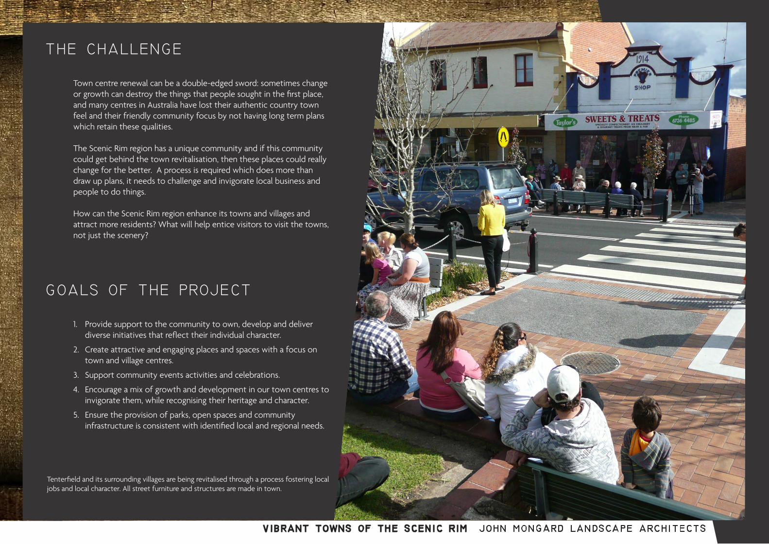
Tenterfield and its surrounding villages are being revitalised through a process fostering local jobs and local character. All street furniture and structures are made in town.
the challenge
Town centre renewal can be a double-edged sword: sometimes change or growth can destroy the things that people sought in the first place, and many centres in Australia have lost their authentic country town feel and their friendly community focus by not having long term plans which retain these qualities.
The Scenic Rim region has a unique community and if this community could get behind the town revitalisation, then these places could really change for the better. A process is required which does more than draw up plans, it needs to challenge and invigorate local business and people to do things.
How can the Scenic Rim region enhance its towns and villages and attract more residents? What will help entice visitors to visit the towns, not just the scenery?
goals of the project
1. Provide support to the community to own, develop and deliver diverse initiatives that reflect their individual character.
2. Create attractive and engaging places and spaces with a focus on town and village centres.
3. Support community events activities and celebrations.
4. Encourage a mix of growth and development in our town centres to invigorate them, while recognising their heritage and character.
5. Ensure the provision of parks, open spaces and community infrastructure is consistent with identified local and regional needs.

vibrant towns of the scenic rim john mongard landscape architects
of many plans...
In a world of increasingly bland suburban sprawl and homogeneous shopping centres, country towns are anchors to real places with authentic public life and events. Country towns in the long run will be the places that large urban centres aspire to as they search for authentic character ,stories and history : things which contemporary development struggles to deliver.
The problem is that we only have one model for growth, and that results in suburban quality and retail centres which are internal and not main street oriented. Even as we grow these towns, we change them from what they were, and inevitably the old main street and surrounding residences are the parts which we value as authentic.
In the main street of Tamborine Mountain and in the high Street of Boonah we find two country towns which have great character and community life. In their surrounding streets, we find houses and landscapes which reaffirm that they are unique country towns. Beaudesert still has a country town feel in its residential areas, although recent urban development in the town centre has been turning it into a bland retail strip.
why country towns matter
The Council, traders, community and artisans need to collaborate and share the same vision and plan.
Scenic Rim Regional Council has policies, frameworks and strategies that contribute to vibrant towns but has been unable to enact them productively. What has been lacking are clear plans that provide an integrated vision and logic for the creation of vibrant towns.
Reviewing the background policies and other relevant documents, we find promising intentions, but looking on the ground at the towns, there is little evidence that the vision has become a reality: the towns do not yet reflect community aspirations.
Vibrancy and activation are vital elements which are yet to fully emerge within the towns. These complex and layered qualities can only be created through collaboration across the whole community, and by involving the creative artisans and local craftspeople who can bring out the special qualities of each place.
Joined up thinking occurs when all groups engage in the process

vibrant towns of the scenic rim john mongard landscape architects
our town centredesign process
How can we keep and foster the country town character? How can we actually make main streets more vibrant and active, even as modern retailing seeks to move those things inside ?
Public spaces are the key to activating towns which have main streets. Unlike shopping malls, main streets are free and open to all. Community life happens in the main street and so country towns, with their stories and events , are defined by the quality of their public realms.
It’s the quality of the public spaces which activates and creates vibrancy: the quality of materials, the quality of the collaborations and the effort put into getting all of the main street to sing to the same tune. To make a visible difference , the focus on each town has to be on building with quality.
building with quality
How do you create vibrancy and activity? The only way is to have a collaborative process all the way from planning through to construction. The Council, traders, community and artisans need to collaborate and share the same vision and plan.
Public spaces are the result of a team effort.
From a Council point of view, the team involves the leaders, the planners, the infrastructure builders and the arts and community services. Everyone from Mayor to gardener needs to know about and contribute to the vision and the plan.
From a business point of view, the team involves the owners and the traders on the main street. From the community’s viewpoint the team involves : the business leaders; the active community groups; the artisans and finally the local builders and fabricators who can bring quality and care to the main street. Finally, people on the street and in shopfronts need to be engaged so that the plans reflect the values and needs of the local people.
a better way
vibrant towns of the scenic rim john mongard landscape architects
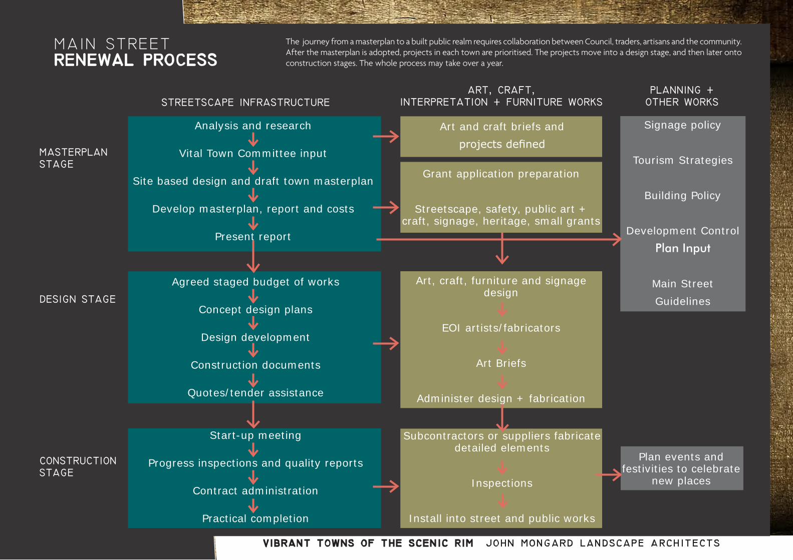
main street renewal process
Analysis and research
Vital Town Committee input
Site based design and draft town masterplan
Develop masterplan, report and costs
Present report
Agreed staged budget of works
Concept design plans
Design development
Construction documents
Quotes/tender assistance
Start-up meeting
Progress inspections and quality reports
Contract administration
Practical completion
masterplanstage
design stage
constructionstage
streetscape infrastructure
Art and craft briefs and projects defined
Grant application preparation
Streetscape, safety, public art + craft, signage, heritage, small grants
Art, craft, furniture and signage design
EOI artists/fabricators
Art Briefs
Administer design + fabrication
Subcontractors or suppliers fabricate detailed elements
Inspections
Install into street and public works
Signage policy
Tourism Strategies
Building Policy
Development ControlPlan Input
Main StreetGuidelines
Plan events and festivities to celebrate
new places
art, craft, interpretation + furniture works
planning + other works
The journey from a masterplan to a built public realm requires collaboration between Council, traders, artisans and the community. After the masterplan is adopted, projects in each town are prioritised. The projects move into a design stage, and then later onto construction stages. The whole process may take over a year.

vibrant towns of the scenic rim john mongard landscape architects
the big picture
Recent Scenic Rim plans and policies provide background and frameworks for detailed masterplanning in relation to the future of the town centres.
The Community Plan 2011-2026 outlines a vision for a network of unique, rural communities and highlights local strengths and issues.
Residents value the outstanding natural environment, scenery, and relaxed lifestyle as well as a strong sense of community. Well-maintained roads are considered a priority and essential for connecting towns and communities. Consultation and opportunities to participate in decision-making are also highly regarded.
Infrastructure, local employment opportunities, protecting the environment, and managing growth represent the most serious challenges for the future. Recreation and tourism are seen by the community to offer the greatest opportunities for the future but need more support from Council. Additional parks and facilities are valued and residents are willing to pay for these services and value the character and local businesses of the towns highly.
The Regional Tourism Strategy of 2011 identified tourism experiences clustered around three districts:
The mountain towns around Tamborine and Canungra (a vibrant tourist area with stunning views, quaint village character and the arts).
The rural towns around Boonah (characterised by scenery, adventure and national parks).
Beaudesert (featuring the rainforests and national parks).
The Social Plan of 2010 highlighted the importance of active, inclusive and strong local communities in the towns of the shire. The Sport and Recreation Plan of 2010 identified the need for an integrated tourism and trails strategy and to have asset management plans for open spaces and facilities. The Cultural Tourism Report of 2010 sought to focus on cultural tourism using open studios.
The Wellbeing Plan and the Parks Strategy of 2015 identifies the need to plan for higher levels of service and quality in the civic areas but does not have any detailed guidance. There are a lot of parks in the shire and Council needs to be mindful of available resources to maintain new facilities. The Economic Development Paper of 2009 identified food and wine industries and small business as key industry areas.
In summary, there are a lot of good aspirations, policies and web based initiatives from Council, but a drive around the Shire shows that the outcomes have not yet been realised. This project can assist to actually deliver the community’s aspirations.
There are high level policies and low level development guidelines but no overall plans in the middle to drive the towns and region forward. This is the intent of the Vibrant Towns project.
vibrant towns of the scenic rim john mongard landscape architects
appendix bhistory of the vibrant towns
vibrant towns of the scenic rim john mongard landscape architects
an indigenous history of the scenic rim
There is a well recorded history of the interaction of the indigenous clans with the early pioneers and peoples of the Scenic Rim. Bennett et al (2000, p.37) describes the location of these clans as follows:
‘When squatters took up pastoral runs in the Upper Logan-Albert district in the early 1840s, they found the land already occupied by people of the Yugambeh (or Yugumbir) language group, whose territory extended from the Logan River to the Tweed, encompassing the Gold Coast and its hinterland, including the Beaudesert region.
The Yugambeh clans belong to the wider Bundjalang language group, whose territory extends from the Logan River to the Richmond River and west to Warwick. To the south-southwest of the Yugambeh is Gidabal territory; and to the north, northeast and northwest is jagara (Yuggera) territory’.
Clans
‘A number of clans, each with defined territory, were located within the Yugambeh language region, including the Mununjali between the Logan and Albert rivers, near Beaudesert and Mundoolun; the Wangerriburra of the Albert River and Coomera headwaters, around Tabragalba, Tamborine, Tamborine Mountain and Canungra; the Migunberri of Tamrookum, Rathdowney, Hillview and Christmas Creek; and the Birinburr in the Binna Burra area’
Reference: Bennett, H. and Queensland Environmental Protection Agency (2000). Beaudesert Shire, Thematic Historical Overview. Overview of historical themes and typologies of associated places.
Another sacred site, reputedly in the Beaudesert area, was a sacred well known as Derringirri. It was described as a sprint-fed rock pool which has never been known to dry up. The old men were the only ones permitted to draw water from it, and a sip of water was customarily given to each new-born baby. The custom suggests that Derringirri was equivalent to dranagan, an ogress sometimes regarded as a fertility goddess.
About the Mununjali Clan
The Mununjali Clan lived in the Beaudesert area. Steele (1984, p. 78) describes the clan as follows:
‘The Mununjali or Manaldjali people, who lived in the Beaudesert area, were named after the “hard black ground” of the district. Two kilometres west of Beaudesert, alongside the racecourse is the lagoon known as Ilbogan; it is a long, winding billabong, covered in hyacinth. Aboriginal folklore held that this was the abode of warrajum, the rainbow serpent. The Ilbogan lagoon features in the important legend of the two dingoes, Burrajahnee and Inneroogun (Burrajan and Ninerung), who chased the kangaroo from Mount Widgee to Ilbogan. The kangaroo jumped into the lagoon and turned into a warrajum; he may now appear in any form he chooses.
Another sacred site, reputedly in the Beaudesert area, was a sacred well known as Derringirri. It was described as a spring-fed rock pool which has never been known to dry up. The old men were the only ones permitted to draw water from it, and a sip of water was customarily given to each new-born baby. This custom suggests the Derringirri was equivalent to derangan, an ogress sometimes regarded as a fertility goddess.’

vibrant towns of the scenic rim john mongard landscape architects
Map of the Wangerriburra Clan’s territory
About the Wangerriburra Clan
The Wangerriburra Clan occurred in the Tamborine Mountain areas proximate to Cedar Creek and extended to other areas including the plains around Tamborine Village. Steele (1984, p. 71) notes that
‘The Wangerriburra clan takes its name from the wallaby, variously known as the pretty-faced or whip-tailed wallaby; it was called wong-ari. The northern extremity of Wangerriburra territory was Cedar Creek, which flows from Tamborine Mountain to the Albert River. About four kilometres upstream on the Albert from the Cedar Creek junction is a remarkable ceremonial ground. When described by John Shirley in 1910 it consisted of three bora rings in a row, connected by a path one kilometre long.’
Trade between the clans
The indigenous clans of the Scenic Rim traded, shared pathways and left evidence of artefacts and sacred sites. Bennett et al (2000, p. 38) notes the richness of trade between clans of the Beaudesert plain with those of Tamborine Mountain.
‘The richness of the trade in implements between the coastal clans and the people of the Upper Logan-Albert river valleys is evidenced at Tamborine Mountain, even today: Implement factory sites, areas of sacred rites, stone arrangements and burial caves are still being discovered on and round the Mountain. European settlers found stone axes and shaped flints in abundance as the land was cleared and keen eyes even today may still find Aboriginal implements in many areas. The most numerous are the small flints, beautifully shaped to fit the fingers. Many were brought from the Coomera district on the east and were found on or near a well-worn pathway that crosses the Mountain from east to west. More rare are the stone axes, which took more time and skill to manufacture.’
Ilbogan Lagoon, near Beaudesert, 1981; the abode of the warrajum. Source: Bennett et al 2000
vibrant towns of the scenic rim john mongard landscape architects
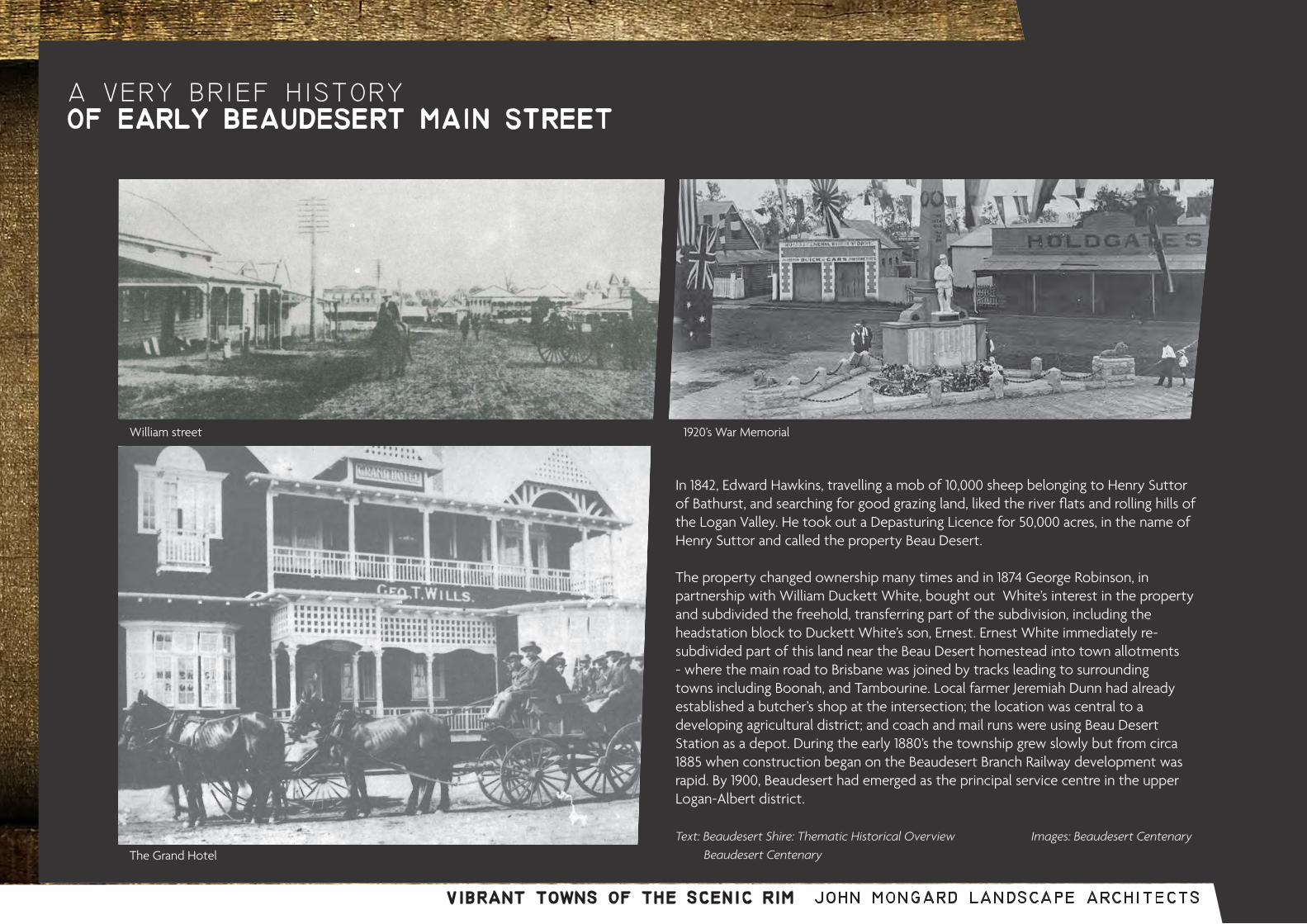
a very brief historyof early beaudesert main street
William street
The Grand Hotel
1920’s War Memorial
In 1842, Edward Hawkins, travelling a mob of 10,000 sheep belonging to Henry Suttor of Bathurst, and searching for good grazing land, liked the river flats and rolling hills of the Logan Valley. He took out a Depasturing Licence for 50,000 acres, in the name of Henry Suttor and called the property Beau Desert.
The property changed ownership many times and in 1874 George Robinson, in partnership with William Duckett White, bought out White’s interest in the property and subdivided the freehold, transferring part of the subdivision, including the headstation block to Duckett White’s son, Ernest. Ernest White immediately re-subdivided part of this land near the Beau Desert homestead into town allotments - where the main road to Brisbane was joined by tracks leading to surrounding towns including Boonah, and Tambourine. Local farmer Jeremiah Dunn had already established a butcher’s shop at the intersection; the location was central to a developing agricultural district; and coach and mail runs were using Beau Desert Station as a depot. During the early 1880’s the township grew slowly but from circa 1885 when construction began on the Beaudesert Branch Railway development was rapid. By 1900, Beaudesert had emerged as the principal service centre in the upper Logan-Albert district.
Text: Beaudesert Shire: Thematic Historical Overview Images: Beaudesert Centenary Beaudesert Centenary
vibrant towns of the scenic rim john mongard landscape architects
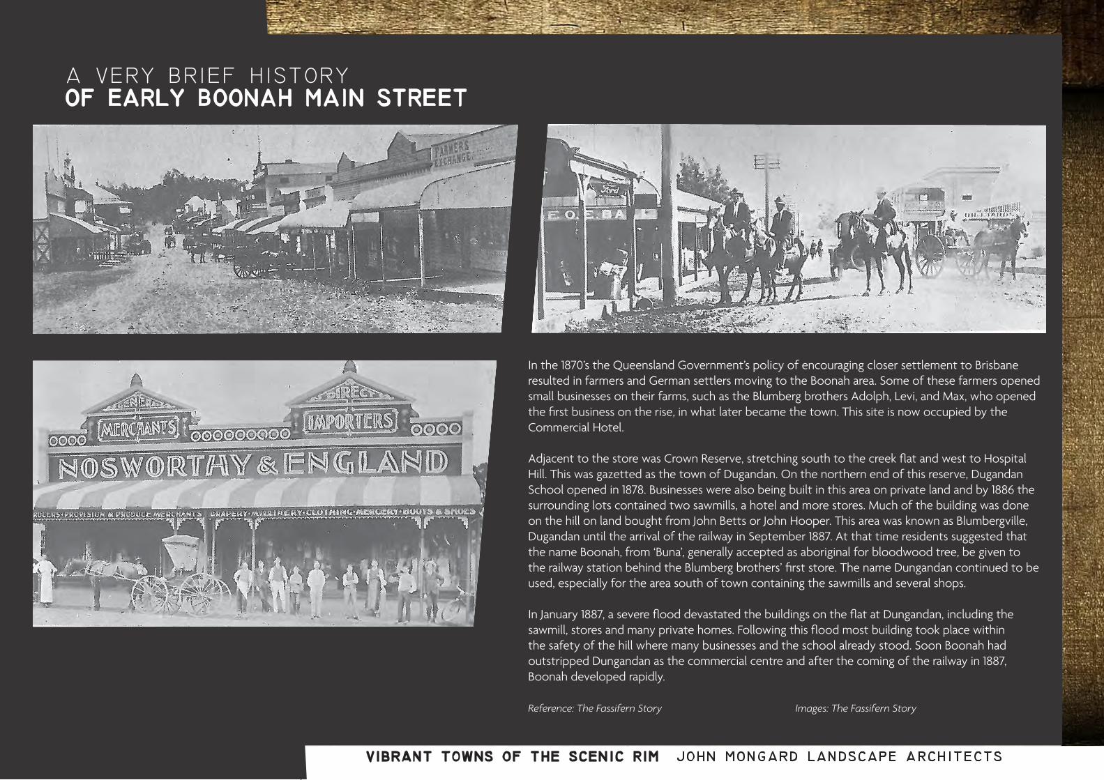
a very brief historyof early boonah main street
In the 1870’s the Queensland Government’s policy of encouraging closer settlement to Brisbane resulted in farmers and German settlers moving to the Boonah area. Some of these farmers opened small businesses on their farms, such as the Blumberg brothers Adolph, Levi, and Max, who opened the first business on the rise, in what later became the town. This site is now occupied by the Commercial Hotel.
Adjacent to the store was Crown Reserve, stretching south to the creek flat and west to Hospital Hill. This was gazetted as the town of Dugandan. On the northern end of this reserve, Dugandan School opened in 1878. Businesses were also being built in this area on private land and by 1886 the surrounding lots contained two sawmills, a hotel and more stores. Much of the building was done on the hill on land bought from John Betts or John Hooper. This area was known as Blumbergville, Dugandan until the arrival of the railway in September 1887. At that time residents suggested that the name Boonah, from ‘Buna’, generally accepted as aboriginal for bloodwood tree, be given to the railway station behind the Blumberg brothers’ first store. The name Dungandan continued to be used, especially for the area south of town containing the sawmills and several shops.
In January 1887, a severe flood devastated the buildings on the flat at Dungandan, including the sawmill, stores and many private homes. Following this flood most building took place within the safety of the hill where many businesses and the school already stood. Soon Boonah had outstripped Dungandan as the commercial centre and after the coming of the railway in 1887, Boonah developed rapidly.
Reference: The Fassifern Story Images: The Fassifern Story

vibrant towns of the scenic rim john mongard landscape architects
a very brief historyof early tamborine main street
For many years the only store on Tamborine Mountain was that opened in 1909 by Mrs Elfriede Geissmann, at her family farm, Capo di Monte, at North Tamborine. At the same time as she ran the store, Mrs Geissmann also operated the Capo di Monte Guesthouse, taught at the Capo di Monte provisional school and raised a large family. Her store was used by all the settlers at the north end of the mountain.
The Geissmann’s store was resited to Main Street in 1921 using skids and a bullock team with Mrs Geissmann serving customers during the process. Following a circa 1920 residential subdivision that retained the store and added a bakery next door, North Tamborine attained a sense of ‘township’.
When the Post Office was opened inside the store, the name was changed from Mt Tambourine to North Tambourine Post Office and the spelling was changed to Tamborine, omitting the ‘u’ in 1926.
North Tamborine grew quickly to include a number of boarding-houses, stores, two cafes, billard-saloon, private residences, public hall (Zamia Theatre, circa 1923) and showground, all set in the midst of mountain charm.
The store, Post Office and butcher shop businesses relocated across the road to a new building on Main Street, between Kidd Street and Reeve Road in 1945. In 1951 Arthur Geissmann (son of Elfriede) added a second storey and lived upstairs while operating the Akala Café below. Henry and Rachel Leber bought the property from Arthur in 1957. Allen and Coral Carter purchased it in 1962 and sold it to ‘Karl’ and Kristina Vogelsang in 1984. Karl’s nephew, Alex Bann and Heike Edrich later owned the corner block which was known as the Main Street Café and is now The Spice of Life.
Text: Beaudesert Shire: Thematic Historical Overview Images: Ripples In The Pond Ripples In The Pond
appendix cpolicy and literature review

vibrant towns of the scenic rim john mongard landscape architects
Goals
Our goals are to: • implement Council policy and plans through
place-based initiative• deliver social, economic, cultural and
environmental outcomes for the community • develop a whole of Council approach, and,• bring Council and community resources
together to maximise project benefits and ensure sustainability after project completion
• mobilise local assets, talents and expertise to enhance towns and villages, and the region as a whole
Outcomes
We seek to focus on:
• enhancing individual towns and villages connecting towns and villages in a meaningful way across the region
• achieve benefits for both residents and visitors• building on Scenic Rim’s vision, aspirations and
priorities
Principles
Our general principles:
• focus on community assets and strengths • identify and mobilise individual and community
assets, skills and passions• connect the built environment with place
identity and community needs• aim to be community and relationship-driven ie
facilitating partnerships
Our specific principles aim to achieve:
• planning that engages the community, provides for future needs, protects the environment and rural lifestyle and contributes to social capital and resilience
• supporting development which strengthens and adds appeal to towns and villages and meet needs of communities
• supporting the community in owning, developing and delivering initiatives
vibrant towns of the scenic rim:project goals
• contributing to tourism development that is consistent with community values and aspirations, and provides broad benefits
• ensuring community infrastructure and public spaces are appropriate to the environment, contribute to attractive and functional places, and serve multiple purposes for all members of the community
• bringing towns and villages alive through affordable and inclusive events, activities and celebrations
• consideration of cultural heritage and capacity for cultural activation in planning and design of public spaces and facilities for visitors and residents
• recognition of Indigenous cultural heritage• connect towns to each other and nearby
points of interest with paths and trails • providing pathways to local employment
(especially young people and disadvantaged groups)

vibrant towns of the scenic rim john mongard landscape architects
Relevant internal and external policies and reports reviewed for the project included:
• Scenic Rim Community Plan 2011-2026 • Scenic Rim Community Plan (Final Phase) Community Consultation Summary• Scenic Rim Regional Council Corporate Plan 2013-2018• Scenic Rim Operational Plan 2015/16 • Scenic Rim Regional Council Health and Wellbeing Plan 2015-2020• Scenic Rim Regional Council Social Plan 2010-2020• Scenic Rim Regional Council Sport and Recreation Plan 2010-2020• Scenic Rim Regional Council Arts and Cultural Policy 2014-2017• Scenic Rim Regional Council Arts and Cultural Policy Review 2008• Scenic Rim Public Art and Collections Policy• Scenic Rim Local Heritage Register• Scenic Rim Three Parks Master Plan Report: Jubilee Park, Beaudesert; Bicentennial Park, Boonah; Youngman Family Park, North Tamborine• Queensland Heritage Register
• Scenic Rim Regional Tourism Strategy 2011-2016• Scenic Rim Regional Council Signage Strategy 2013-2015• Scenic Rim Visitor Information Centre Policy (as amended June 2014)• Scenic Rim Regional Council Library Proposal 2010• Draft Scenic Rim Region Activity Centre Strategy 2014
scenic rim policy review
• South East Queensland Regional Plan 2009-2031• Arts for all Queenslanders Strategy 2014-2018
• Bromelton Employment, Industrial Land Demand, Freight Demand and Generation Study - 2008 Update• Commercial Feasibility Study, 71 High Street Boonah, 2009• Discussion Paper Beaudesert Central Business District Centre Development Plan 2011• South East Queensland Employment and Economic Activity Forecasting Project 2015. LGA Summary Report: Scenic Rim Regional Council• Beaudesert Growth Management Strategy 2012- 2031• Draft Discussion Paper for Recreation Plan for Beaudesert Shire• Landscape Assessment of Tamborine Mountain 1994• Moreton Region Vegetation Map Series• Tamborine Mountain Urban and Landscape Character Study

vibrant towns of the scenic rim john mongard landscape architects
Scenic Rim Community Plan 2011-2026
The Community Plan articulates the vision, priorities and plan for the region’s future and guides Council’s strategic, operational and financial decision-making. Scenic Rim’s shared vision of ‘a network of unique rural communities embedded in a productive and sustainable landscape’, is directly relevant to the Vibrant and Active Towns of the Scenic Rim project. Vibrant towns and villages are a key theme of the Community Plan and a feature of the region’s identity. The Scenic Rim defines itself through the heritage and character of its towns and villages with their open spaces, service-oriented business community, and easy-going lifestyle. Other integral elements of the region’s identity are its strong social networks, long-term residents’ links with local history, diverse communities, the vibrancy of its creative industries and its stunning views and landscape.
Vibrant Towns and Villages are envisioned in the Community Plan as:
• character-filled towns and villages that meet needs of communities
• thriving main streets valued by residents, visitors and businesses
• distinct edges provide sense of arrival• heritage housing and buildings at heart• appealing, welcoming towns and villages
that serve community• Beaudesert as a modern centre that respects
its country heritage• Tamborine Mountain and Beechmont
sustained as productive green sanctuaries Boonah and Canungra evolve into thriving rural towns and hubs for recreation, tourism and sustainability
Priorities include:• understanding an enhancing things residents and visitors value about character and heritage• supporting development which strengthens and adds appeal to towns and villages• creating attractive, pedestrian-friendly and engaging places in town centres• encouraging mix of growth and development in Beaudesert to invigorate town centre• protect unique character of Boonah town centre and residential surrounds• protect Tamborine Mountain’s creative lifestyle and unique natural environment by managing tourism and development• supporting the community in owning, developing and delivering initiatives that drive vibrant towns and villages• bringing towns and villages alive through events, activities and celebrations
Other themes outlined in the Community Plan are also highly relevant to the Vibrant and Active Towns of the Scenic Rim project.
Spectacular Scenery and Healthy Environment is seen as a valued asset and central to future lifestyle, wellbeing and prosperity.
Priorities include:• managing development that could impact on views and vistas
Sustainable and Prosperous Economy will require a diverse economy built upon localisation principles, with agriculture and tourism central supported by emerging industries.
Priorities include:• encouraging local investment and support local business – marketing and brandingg
• infrastructure and built environment that Healthy, Engaged and Resourceful Communities with strong social interaction, a sense of connectedness, and a community that celebrates its identity, culture and diversity.
Relaxed Living and Rural Lifestyle with rural and regional character, and heritage maintained, landscapes, open spaces and green corridors retained, and facilities and spaces available for outdoor recreation.
Priorities include:• building streets and urban areas that complement and blend with the rural environment• effective planning that engages the community, provides for our future needs and protects the environment and rural lifestyle
Open and Responsive Government with transparent government that invites participation and encourages constructive debate.
Accessible and Serviced Region
Priorities include:• Ensuring community infrastructure is appropriate
for our environment, contributes to attractive and functional places, and serves multiple purposes
• Rationalising or reinvigorating poorly used infrastructure and services
• Ensuring new infrastructure needed to support residents, visitors and a growing economy is provided in time and is funded by those who benefit most
Healthy, Engaged and Resourceful Communities with strong social interaction, a sense of connectedness, and a community that celebrates its identity, culture and diversity.
policy and planningcontext

vibrant towns of the scenic rim john mongard landscape architects
Priorities include:• Strengthening social interaction, building
partnerships and connectedness through activities and infrastructure
• Building an active and healthy community through sport, parks, community gardens and recreation
• Celebrating and recognising the diversity of our culture and Aboriginal traditions and encouraging artistic and creative expression
• Creating a sense of identity and belonging• Providing affordable activities, services and
public spaces that meet the needs of children and young people
Health and Wellbeing Plan 2015-2020
The Health and Wellbeing Plan highlights strengths within the Scenic Rim community and reflects important community needs across the region. Participation in volunteering and sports, and strong support networks are evidence of a connected community. As the population grows and changes, continuing to provide relevant social and cultural activities and the places where these can occur, are an important way to improve people’s health and wellbeing.
Investing in community infrastructure that provides accessible spaces for people to gather and connect is important in delivering social, health and economic benefits. Community infrastructure such as pathways and footpaths, community centres, parks and playgrounds, public halls, libraries, skate parks and cultural centres all contribute to the health and wellbeing of residents.
Key recommendations for the next five years include:• events and programs delivered by arts and cultural
organisations including libraries through initiatives including the Vibrant and Active Towns and Villages initiative
• community celebrations to promote social inclusion and cohesion
• walking and cycling facilities - shaded, views,
well-lit and connected to other circuits• paths and trails that connect towns to each
other and nearby points of interest• parks with spaces for gathering, meeting
and being physically active including Jubilee Park in Beaudesert, Coronation Park in Boonah, Youngman Park in Tamborine Mountain
Scenic Rim Arts and Cultural Policy 2014-2017
The Arts and Cultural Policy expresses Council’s commitment to cultural development to enhance residents’ quality of life, promote the region’s identity, and maintains and develops the unique identity of its individual towns, villages and communities.
Central policy goals include: 1) building community capacity through arts and culture, 2) enabling the region to appreciate, realise and articulate its local heritage and identity, and, 3) promoting and generating creative excellence.
Policy goals, objectives and strategies detailed in the Policy relevant to the Vibrant and Active Towns of the Scenic Rim project are outlined below:
Goal 1: The building of community capacity through the arts. Key strategies include:• consideration of cultural heritage and capacity for
cultural activation in planning and design of public spaces and facilities
• support for art and cultural initiatives that demonstrate cooperation and collaboration between community organisations, schools and businesses
• providing, maintaining and managing facilities and infrastructure that nurtures community cultural development including cultural precincts and hubs
Goal 2: A region able to fully appreciate, realise and articulate its heritage and identity. Key strategies include:• supporting the collection of locally significant stories • recognition of our Indigenous cultural heritage
• investing in and raise awareness of the value of our heritage and regional distinction for visitors and residents.
Goal 3: The promotion and generation of creative excellence• promote exposure to culture through programming at
cultural centres, libraries and at community events
Public Art and Collections Policy 2012
The Public Art and Collections Policy is closely aligned to community development and wellbeing priorities for the Scenic Rim.
One key policy objective relevant to the Vibrant and Active Towns of the Scenic Rim project is support for initiatives that:• provide interpretive signage and public art that has local
or regional relevance, • explains meaning behind place names, and• gives insight into the natural and cultural heritage of our
towns and villages and significant related sites
Local Heritage Register 2010-2020
The Local Heritage Register offers an opportunity to gain an understanding and appreciation of the Scenic Rim’s history: its evolution, unique features, principal characteristics, aesthetic and achievements. There is potential for these significant cultural assets to be integrated into future planning including the Vibrant and Active Towns of the Scenic Rim project.
Key sites relevant to the first stage of the project include:
Beaudesert• showgrounds, Council Chambers, St Thomas’s church,
hotel, Masonic Centre, and St Mary’s church

vibrant towns of the scenic rim john mongard landscape architects
Community Ideas for Council Policy AreasThe consultation process across the towns has unearthed a broad range of ideas and issues not only about how to improve the towns, but also ideas on better management and governance across the spectrum of Council. Ideas were collated from the consultation into departmental streams to assist with identifying how vibrancy can be promoted across the organisation:
Beaudesert
Boonah• Flavour’s café, Christ Church, Commercial Hotel,
and showgrounds
Tamborine Mountain• Former Presbyterian church, former Mountain Crest
guesthouse, Zamia theatre, showgrounds and hall, former Templin school, and Trelawney Cheese Factory Refrigerator Shed
• State Heritage Register
Key sites relevant to the first stage of the project include:
Beaudesert• War Memorial
Boonah• War Memorial and park• Coochin Coochin Homestead
Tamborine Mountain• Tamborine Mountain Road/Geissmann Drive
The Aboriginal and Torres Strait Islander cultural heritage database administered by the Department of Aboriginal and Torres Strait Islander Partnerships is not publicly available but is likely to include relevant cultural heritage. Plants of Tamborine Mountain.

vibrant towns of the scenic rim john mongard landscape architects
Infrastructure A dog park area within Jubilee Park
More tables and chairs in local parks – Jubilee and Davies parks Need zebra crossing at ANZ bank and the library Improve the crossing in front of Council Chambers Improve the street frontage of Woolworths Need more benches near Woolworths, Coles and Aldi More rubbish bins, particularly at gathering areas Revegetation near the race course More flowers, trees, greenery throughout Beaudesert town centre
Boonah
CDO Need a bush tucker garden
Need a Mens’ Shed Need a youth centre - alternatives to sporting activities
Sport & Rec Infrastructure
Improve the soccer pitch Create a water park Biking community needs support including cycle tracks, signage, parking facilities/bike racks at each end of town Skate park needs shade. Provide a small kids area with seating Need lighting along the path around the oval and on to the exercise park Need jogging/running tracks/circuits with lighting
Economics Tourism Arts & Culture
Promote extended trading hours Better signage to amenities More story telling - promote walking trails, look out points, significant sites eg old railway line, names Mountains etc. Digital information board - in forecourt near clock Improved tourism and enterprise signage Places for buskers and musicians More frequent movie screenings Encourage new business by offering incentives Free WiFi zone
Infrastructure Tourism
Viewing point at the big Fig Tree on Boonah / Ipswich Rd Better promotion and improvement of rail track walking loop with more trees, seats, stories, fishing, long walking trails More trees at the Visitor Information Centre More trees around schools More flowers around town. Provide tree names on trees Remove redundant signage Designated caravan parking on Walter Street Fix Boonah sign on Mt Carmel Hill and illuminate it Fix the Park at bottom of Mt Carmel Free WiFi zone Defined drop off parking point for coaches Second wheel chair park at IGA Need special lighting for the clock as currently it is ineffective because of the old spotlights on the corner of the building which light the Australian flag Drinking fountains and dog fountains Off leash dog park
North Tamborine - Main Street
CDO Xmas markets
Youth centre / drop in centre
Swimming pool covered and heated Arts & Culture More story telling - stories of buildings
Regular music events Tourism Infrastructure
Mt Tamborine is confusing due to 3 different names - better signage needed Upgrade path from Main St to Gallery Walk Need a footpath on Wongallanan Road Defined footpath at Shell service station Walking tracks linking schools, sports grounds etc Contemporary childrens playground - art/ play objects for kids that reflect rural heritage More facilities for cyclists, bike racks, places for groups to gather War memorial access not good Guisemann Road unaccessible Disabled parking required in front of RSPCA shop Longer parking lengths to accommodate trailers going to and from the dump More bins Need a waste recycling tip shop Provide the infrastructure for easy hanging of Xmas lights and other festive occasions
Boonah
CDO Need a bush tucker garden
Need a Mens’ Shed Need a youth centre - alternatives to sporting activities
Sport & Rec Infrastructure
Improve the soccer pitch Create a water park Biking community needs support including cycle tracks, signage, parking facilities/bike racks at each end of town Skate park needs shade. Provide a small kids area with seating Need lighting along the path around the oval and on to the exercise park Need jogging/running tracks/circuits with lighting
Economics Tourism Arts & Culture
Promote extended trading hours Better signage to amenities More story telling - promote walking trails, look out points, significant sites eg old railway line, names Mountains etc. Digital information board - in forecourt near clock Improved tourism and enterprise signage Places for buskers and musicians More frequent movie screenings Encourage new business by offering incentives Free WiFi zone
Infrastructure Tourism
Viewing point at the big Fig Tree on Boonah / Ipswich Rd Better promotion and improvement of rail track walking loop with more trees, seats, stories, fishing, long walking trails More trees at the Visitor Information Centre More trees around schools More flowers around town. Provide tree names on trees Remove redundant signage Designated caravan parking on Walter Street Fix Boonah sign on Mt Carmel Hill and illuminate it Fix the Park at bottom of Mt Carmel Free WiFi zone Defined drop off parking point for coaches Second wheel chair park at IGA Need special lighting for the clock as currently it is ineffective because of the old spotlights on the corner of the building which light the Australian flag Drinking fountains and dog fountains Off leash dog park
North Tamborine - Main Street
CDO Xmas markets
Youth centre / drop in centre

vibrant towns of the scenic rim john mongard landscape architects
Reference books reviewed for the project included: AECOM (2013). Evaluation of Regional rail and Intermodal Projects under Regional Development Victoria’s Infrastructure Fund. A regional rail evaluation for the Department of State Development, Business and Innovation Victoria
ARUP (2012). Designing the Soft Infrastructure for a 21st Century Library. A report prepared for the State Library of New South Wales. ARUP Informatics: Sydney
ARUP (2015). Future Libraries. Workshops Summary and Emerging Insights. ARUP University: London
Beaudesert Shire Council (2005). Your Guide to the Common Plants of Beaudesert Shire. Beaudesert Shire Council: Queensland
Bennett, H. and Queensland Environmental Protection Agency (2000). Beaudesert Shire, Thematic Historical Overview. Overview of historical themes and typologies of associated places.
Cavage Community Development Social Plan 2010-2020
Chenoweth and Associates (2001). Tamborine Mountain Escarpment Flora and Fauna Report.
Day, P (2016). Original Cartoons, Trailblazing Arts Diner, April 19th, 2016.
Deicke Richards (2000). Tamborine Mountain Urban and Landscape Charcter Study, Tamborine Net.
Deloitte (2015). The Purpose of Place Reconsidered. Building the Lucky Country, Business Imperatives for a prosperous Australia; Vol. 5
Economic Associates (2009). Bromelton Employment, Industrial Land Demand, Freight Demand and Generation study - 2008 Update.
Fawdon and Sharp (2015). Eat Local - Food, Farming and Conversation in the Scenic Rim, Scenic Rim Regional Council: Queensland
Guyatta, J. (1997). ‘A Natural History of Tamborine Mountain’. Tamborine Mountain Natural History Association: pg. 147
McKinney, M., Wright, J. (2010). Birds. National Library of Australia
Mode Architects (2016). Feasibility Study For The Conversion Of An Existing Vacant IGA Supermarket Tenancy to a Council Library with Community Facilities.
North Tamborine Community Cente (2014). Renovations to the Vonda Youngman Community Centre. A proposal to the Scenic Rim Regional Council. Presented October, 2014
Nutting, K. (no date). Then and Now. The Story of Beaudesert 1874-1974. Beaudesert Times: Queensland
Olver, S. (2005). The Scenic Rim. Dawn to Dusk Publishing: Queensland
Pfeffer, C. K. (1991). The Fassifern Story. A History of Boonah Shire and Surroundings to 1989. Boonah Shire Council: Queensland
Piper, L. (no date). The Ripples In My Pond. Stories about the mountain,Tambourine library reference
Ross Planning (2010). Scenic Rim Regional Council: Sport and Recreation Plan 2010-2020, Queensland
Scenic Rim Regional Council (2011). Beaudesert Growth Management Strategy 2011-2013, Scenic Rim Regional Council: Queensland
Scenic Rim Regional Council (2008). Community Consultaion Outcomes and Background Research Arts and Cultural Policy Review, Scenic Rim Regional Council: Queensland
Scenic Rim Regional Council (2011). Community Plan 2011-2026, Scenic Rim Regional Council: Queensland
Scenic Rim Regional Council (2014). Draft Activity Centre Strategy, Scenic Rim Regional Council: Queensland
Scenic Rim Regional Council (2016). Draft Strategic Plan, Scenic Rim Regional Council: Queensland
Scenic Rim Regional Council (2016). Tourism Signage Strategy, Scenic Rim Regional Council: Queensland
Stelle, J. G. (1984). Aboriginal Pathways in SouthEast Queensland and the Richmond River. University of Queensland Press: Queensland
Tamborine Mountain Natural History Association (1997). Checklist: Trees, shrubs, palms and vines of Tamborine Mountain Accessed by: http://naturalhistory.org.au/~natural2/tmsite/phocadownload/knowledge/tmnha_checklist_trees-shrubs-palms-vines.pdf
Urban Economics (2009). Commercial Feasibility Study - 71 High Street , Boonah.
Veitch Lister Consulting (2015). Scenic Rim Regional Council - Transport Infrastructure Review, September 2015.
scenic rim literature review