version 7.0 fiscal analysis buffer mitigation rules (15a ... management commission/emc... ·...
TRANSCRIPT

VERSION 7.0
Fiscal Analysis –Buffer Mitigation Rules
(15A NCAC 2B .0295, .0242, .0244, .0252, .0260, .0268, and .0609)
Prepared by NC Division of Water Quality staff
October 10, 2012
Rule Citation Numbers –
15A NCAC 2B .0295: Mitigation Program Requirements for Protection and Maintenance of Riparian
Buffers
15A NCAC 02B .0242: Mitigation for Existing Buffers in the Neuse River Basin
15A NCAC 02B .0244: Mitigation for Existing Buffers in the Catawba River Basin
15A NCAC 02B .0252: Randleman Lake Mitigation for Existing Buffers
15A NCAC 02B .0260: Mitigation for Existing Buffers in the Tar-Pamlico River Basin
15A NCAC 02B .0268: Jordan Lake Mitigation for Existing Buffers
15A NCAC 02B .0609: Goose Creek Watershed Buffer Mitigation Rule
(Appendix)
DENR Division - Division of Water Quality
Agency Contact: Amy Chapman
Division of Water Quality
1650 Mail Service Center
Raleigh, NC 27604
(919)- 807-6400
mailto:[email protected]
Impact Summary:
State Government: Yes
N.C. Department of Transportation: Yes
Local Governments: Yes
Federal Government: Yes
Small Businesses: Yes
Substantial Impact: Yes
Authorizing Statutes: G.S. 143-214.5; G.S. 143-214.7; G.S. 143-214.20; G.S. 143-215.3(a)(1); G.S. 143-
215.6A; G.S. 143-215.6B; G.S. 143-215.6C; G.S. 143-215.8A; G.S. 143 215.8B; G.S. 143B-282(c),(d);
S.L. 1998, c. 221; S.L. 1999, c. 329, s. 7.1, S.B. 824-2003; S.L. 2005-190; S.L. 2006-259.
Statement of Necessity: These proposed rule changes in Rule 2B .0295 will provide mitigation options
not currently available to DOT, developers, and private individuals. In addition to providing greater
regulatory flexibility, the proposed changes incorporate contemporary technical and operational
techniques into the rules. These proposed amendments adhere to the Principles of Executive Order 70
Rules and were developed through a public stakeholder process. The new rules advance the public
interest and are designed to achieve their objectives in a cost-effective and timely manner.

The division also seeks to repeal the current buffer mitigation rules (2B .0242, .0244, .0252, .0260,
.0268, and .0609), since they are proposed to be consolidated and replaced by 15A NCAC .02B .0295,
“Mitigation Program Requirements for Protection and Maintenance of Riparian Buffers”. The purpose
of this consolidation is to bring consistency to the current riparian buffer mitigation rules. A reduction in
the number of rules is in the public interest and consistent with the principles of Executive Order 70.
I. Executive Summary:
First of all, the proposed rule will consolidate six existing buffer mitigation rules into one buffer
mitigation rule. This purpose of this consolidation is to bring consistency to the currently riparian buffer
mitigation rules. The current buffer mitigation rules that will be repealed and essentially combined into
rule .0295 include:
15A NCAC 02B .0242: Mitigation for Existing Buffers in the Neuse River Basin
15A NCAC 02B .0244: Mitigation for Existing Buffers in the Catawba River Basin
15A NCAC 02B .0252: Randleman Lake Mitigation for Existing Buffers
15A NCAC 02B .0260: Mitigation for Existing Buffers in the Tar-Pamlico River Basin
15A NCAC 02B .0268: Jordan Lake Mitigation for Existing Buffers
15A NCAC 02B .0609: Goose Creek Watershed Buffer Mitigation Rule
The second part of this rulemaking would provide additional mitigation options for the regulated
community and allow for the flexibility that has been requested by the various stakeholder groups in
these mitigation rules. Stakeholders have expressed concern to the Division of Water Quality (Division)
that they are unable to build their projects because they cannot achieve the amount of buffer mitigation
required in the current buffer mitigation rules. The proposed rule would address this issue by providing
a variety of new mitigation options for those areas where the current buffer mitigation rules are not
feasible. An example of this is that in the Tar-Pamlico 05 8-digit Hydrologic Unit (HUC), there are no
more viable buffer mitigation sites that would adhere to the current buffer mitigation rules.
Stakeholders have stressed the necessity of the consolidated buffer mitigation rule to allow for flexibility
in difficult situations such as this. In several instances, if the stakeholders are unable find acceptable
buffer mitigation for their proposed or actual permits, then thousands of jobs could potentially be lost.
It is important to note that this proposed rule will not expand the area subject to riparian buffer rules.
Finally, the rules address related mitigation issues to ensure that the replacement for the unavoidable
impacted buffers will reduce future nutrient loading. The proposed rules are authorized by G.S. 143-
214.20 which states (in part) “Construction of an alternative measure (of buffer mitigation) that reduces
nutrient loading as well as or better than the riparian buffer that is lost.”
These options were developed to give regulated parties greater flexibility and potentially lower cost of
compliance by providing additional options for buffer mitigation. Other proposed changes to the buffer
mitigation rules may reduce the cost of mitigation on a case-by-case basis (for instance the allowance of
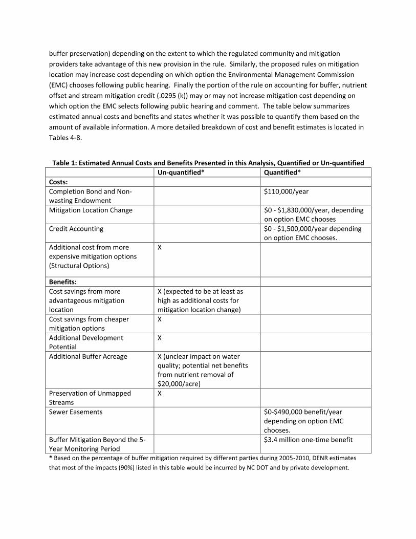
buffer preservation) depending on the extent to which the regulated community and mitigation
providers take advantage of this new provision in the rule. Similarly, the proposed rules on mitigation
location may increase cost depending on which option the Environmental Management Commission
(EMC) chooses following public hearing. Finally the portion of the rule on accounting for buffer, nutrient
offset and stream mitigation credit (.0295 (k)) may or may not increase mitigation cost depending on
which option the EMC selects following public hearing and comment. The table below summarizes
estimated annual costs and benefits and states whether it was possible to quantify them based on the
amount of available information. A more detailed breakdown of cost and benefit estimates is located in
Tables 4-8.
* Based on the percentage of buffer mitigation required by different parties during 2005-2010, DENR estimates
that most of the impacts (90%) listed in this table would be incurred by NC DOT and by private development.
Table 1: Estimated Annual Costs and Benefits Presented in this Analysis, Quantified or Un-quantified
Un-quantified* Quantified*
Costs:
Completion Bond and Non-wasting Endowment
$110,000/year
Mitigation Location Change $0 - $1,830,000/year, depending on option EMC chooses
Credit Accounting $0 - $1,500,000/year depending on option EMC chooses.
Additional cost from more expensive mitigation options (Structural Options)
X
Benefits:
Cost savings from more advantageous mitigation location
X (expected to be at least as high as additional costs for mitigation location change)
Cost savings from cheaper mitigation options
X
Additional Development Potential
X
Additional Buffer Acreage X (unclear impact on water quality; potential net benefits from nutrient removal of $20,000/acre)
Preservation of Unmapped Streams
X
Sewer Easements $0-$490,000 benefit/year depending on option EMC chooses.
Buffer Mitigation Beyond the 5-Year Monitoring Period
$3.4 million one-time benefit
Based on this analysis, the proposed rules will have a net benefit to stakeholders by allowing them to
construct projects the current buffer mitigation rules prohibit. General economic theory asserts that if a
site developer chooses to use one of these options then, to that individual, the increased cost is lower
than the expected project benefits. Projects undertaken using optional mitigation options would result
in a net benefit of undetermined value. Based on 2005-2010 data on entities seeking mitigation, the
agency estimates that more than half of the costs and benefits would be ultimately incurred by DOT,
and more than a third by private developers. Aside from the sewer easement benefit to municipalities,
other state agencies and local governments would only see a small portion of the costs and benefits
presented in Table 1. DENR does not expect any significant changes related to overseeing the
implementation of most of the options in these rules, with the exception of Option 2 for buffer and
stream mitigation accounting. Based on the quantified impacts, the 5-year net present value of costs is
estimated at $0.45 -1.41 million and of benefits at $3.4 -5.2 million, depending on what options EMC
adopts. Again, note that given the voluntary nature of the great majority of the requirements, the
benefits would likely offset any additional costs.
There also may be public benefit in the form of less water pollution at the estuary if these proposed
rules increase the total amount of buffer acreage. Although, water quality in some locations before the
estuary point may be affected, depending on hydrological and geological properties of the location and
if mitigation occurs further from the impact area. Given the uncertain impact of water quality, DENR is
inviting the public to comment on this issue.
The main source of uncertainty in this analysis is the number of options available for particular choices
as well as the inherently variable cost of land and applicability of specific options for specific sites.
Through the public hearing process, stakeholders will comment on the options presented in this analysis
to assist the EMC in selecting final rule language. The fiscal note has investigated the potential cost and
benefits associated with different options and the division will amend the note after the public
comment period to reflect any policy changes.
II. Background and Description of Proposed Rules:
This fiscal analysis was prepared to assist members of the EMC and the public in their review of the
proposed Alternative Buffer Mitigation Rules (15A NCAC 2B .0295). Requests from the regulated
community for more flexibility to achieve mitigation prompted this rulemaking. The division developed
these rules with extensive input from stakeholders meetings held on February 9, 2009, December 9,
2009 and April 6 and 19, 2010. The draft rules were presented to the Water Quality Committee (WQC)
of the EMC on September 2009, November 2009, November 2010, January 2011, March 2011, July 2011,
September 2011, January 2012 and May 2012. In July 2012, the rules were taken to the full EMC. The
WQC requested consideration of three different alternatives for calculating the amount of required
mitigation based on location considerations and for the accounting of buffer, stream and nutrient offset
credits.
Several stakeholders have expressed concerns about the lack of buffer mitigation options. Presently the
two options are payment into a mitigation bank or planting a buffer along a stream that currently is not

planted. This issue is important to address because in some areas of the Tar-Pamlico basin, there are no
more viable buffer mitigation sites for compliance with the current buffer mitigation rules. Stakeholders,
including companies and professional site developers, are unable to proceed with projects if they need
to mitigate for buffers in that area. Potentially thousands of jobs could be lost if alternative buffer
mitigation measures are not allowed.
These proposed rule amendments adhere to the Principles of Executive Order 70 Rules and seek to
reduce the impact on regulated parties by allowing more mitigation options. The proposed rule change
serves the public interest and is designed to achieve their objectives in a cost-effective and timely
manner. None of these alternative mitigation options would be required. Rather, stakeholders and
mitigation providers would pursue these options on a case-by-case basis. These amendments also are
intended to protect the applicable estuaries and increase the water quality in these estuaries. Other
proposed rule changes would update standard practices, scientific information, and the information
provided during the stakeholder process outlined above. An analysis of each of the main provisions
proposed in rule .0295, above what is currently required in the rules proposed repealed, follows in the
next section of this fiscal analysis. This analysis uses the present practice of buffer mitigation based on
the average requirements for buffer mitigation from 2005 thru 2010 from the Division’s Basinwide
Management System (BIMS) permit tracking system as a baseline. The main proposed rule provisions
are:
A. Provisions that apply to all buffer mitigation options;
B. Approaches that apply to all mitigation proposals; and
C. Optional methods of buffer mitigation allowed in the proposed rules.
A. Buffer mitigation provisions
Three new provisions in the rules would apply to any proposed approach for buffer mitigation. These
are:
a. Conservation easements;
b. Completion bonds; and
c. Non-wasting endowments for long term operation and maintenance.
Conservation easements are in the current buffer mitigation rules. Completion bonds and non-wasting
endowments are standard requirements of compensatory mitigation for wetland and stream mitigation
for 404/401 permitting under the Clean Water Act for many years, but have not been required
consistently to buffer mitigation requirements for the state’s riparian buffer protection programs. As
such, these requirements may or may not increase the cost of buffer mitigation compared to the
present cost of mitigation as outlined in Section III below. The proposed changes require that these new
measures provide equivalent types and levels of protection to what is currently in the buffer mitigation
rules.

B. Approaches applying to all mitigation proposals
a. Mitigation Location. The present rules require location of the mitigation to be as close or
closer to the impact “as feasible”. The division and the mitigation banking community have
long interpreted this rule to mean that mitigation will be required in the standard 8-digit
Hydrologic Unit (HUC) as used for the 404/401 permitting programs.1 A HUC’s number is
inversely related to the size of its watershed. The larger the HUC number, the smaller its
watershed.
The proposed rule change would allow for mitigation outside of the standard 8-digit HUC, as
long as a location multiplier is applied after the area of mitigation is computed. To
determine the area of mitigation under the present rules, an impact multiplier is applied to
the area of buffers impacted by the project: if Zone 12 of the buffers is impacted, a multiplier
of 3 is applied to the area of impact (a multiplier of 2 in the Catawba River Basin), and if
Zone 23 of the buffers is impacted, a multiplier of 1.5 is applied to the area of impact. None
of these options would increase or decrease water quality benefits to the estuary. The
proposed rule maintains the impact multipliers and offers three options for location
multipliers as follows:
i. Option A - Mitigation would continue to be allowed within the 8-digit HUC, and then
it would also be allowed at a higher multiplier (2.0) in the adjacent HUC. Example: If
mitigation is done in an adjacent HUC and assuming 200 square feet of Zone 1
buffer impacts, the area of mitigation would have to be 1,200 sq ft [=200sqft of
impact × 3 impact multiplier is required for Zone 1 impacts × 2 for an adjacent HUC
multiplier= 1,200 sq ft.
ii. Option B - Mitigation on-site would benefit from a reduced multiplier of 0.75;
mitigation within the 12-digit HUC at the subwatershed level would only be subject
to Zone 1 and Zone 2 impact multipliers; mitigation within the 8-digit HUC would be
at a higher (1.5) multiplier; and mitigation would be allowed within the adjacent 8-
digit HUC at a higher (2) multiplier.
1 Note that a single 8-digit HUC occupies a larger area that a single 12-digit HUC. For instance, there are four 8-digit
HUC’s in the Neuse basin and seventy-five 12-digit HUCs in the same river basin. 2 For intermittent and perennial streams, Zone 1 begins at the most landward limit of the top of the bank or the
rooted herbaceous vegetation and extends landward a distance of 30 feet on all sides of the surface water, measured horizontally on a line perpendicular to a vertical line marking the edge of the top of the bank. For ponds, lakes and reservoirs located within a natural drainage way, Zone 1 begins at the most landward limit of the normal water level or the rooted herbaceous vegetation and extends landward a distance of 30 feet, measured horizontally on a line perpendicular to a vertical line marking the edge of the surface water or rooted herbaceous vegetation. 3 Zone 2 starts at the outer edge of Zone 1 and extend landward 20 feet as measured horizontally on a line
perpendicular to the surface water.

Table 2: Mitigation Option B
Adjacent 8-digit HUC Within 8 digit HUC Within 12 digit HUC Mitigation option
n/a n/a 0.75 1) On site mitigation
2.0 1.5 1 2) All other types of mitigation
Example: If mitigation is done within the 12-digit HUC with on-site mitigation and
assuming 200 square feet of Zone 1 buffer impacts, the area of mitigation would be
450 sq ft [=200sqft of buffer impact × 3 impact multiplier is required for Zone 1
impacts × 0.75 for the 12 digit HUC multiplier].
iii. Option C - Mitigation on-site would be at a reduced (0.75) ratio, within the 12-digit
HUC at a reduced (0.75) ratio, and then within the adjacent 8-digit HUC at a higher
(2.0) multiplier.
Table 3: Mitigation Option C
Adjacent 8-digit HUC Within 8-digit HUC Within 12-digit HUC Mitigation option
n/a n/a 0.75 1) On site mitigation
2.0 1.0 0.75 2) All other types of mitigation
Example: If mitigation is done in an adjacent 8-digit HUC with coastal headwater
stream mitigation and assuming 200 square feet of Zone 1 buffer impacts, the area
of mitigation would be 1,200 sq ft [=200sqft of impact × 3 impact multiplier is
required for Zone 1 impacts × 2 for an adjacent 8-digit HUC multiplier for all other
types of mitigation].
b. Accounting for buffer, nutrient offset and stream mitigation credit. The rule proposes
three options to address this issue. The current rules do not address accounting for buffer,
nutrient and stream mitigation credit. The division currently uses Option 1 outlined below
but this issue has generated considerable controversy. Comparing these different proposals
will give the EMC, regulated community and others more information about the benefits
and drawbacks to each option.
i. Option 1 - Buffer (or nutrient offset) and stream mitigation credits can be counted
for both sets of credits on a particular mitigation site. However, buffer and nutrient
offset credits cannot be provided at the same location on the same site, nor can
sites that are offering wetland mitigation also provide buffer or nutrient offset
credit. The division presently uses this option for the existing rules.
ii. Option 2 - Buffer (or nutrient offset) and stream mitigation credits could only be
counted for both sets of credits if the impact also was to both streams and buffers.
This option would require the division to determine if impacts were to buffers only
(impacts which are parallel to streams) rather than to both streams and buffers
(impacts which cross streams). The type of required mitigation would then be
matched up with the type of mitigation (stream and buffer versus buffer only). This
would complicate the tracking of buffer and stream mitigation for mitigation
providers and may result in some stream mitigation credits being unusable for
compensatory mitigation in instances where only buffer mitigation is required. The
potential benefit is that stakeholders would have more opportunity to obtain buffer
mitigation credits since more buffer mitigation opportunities would exist. As in
Option 1, buffer and nutrient offset credits cannot be provided at the same location
on the same site nor can sites that are offering wetland mitigation also provide
buffer or nutrient offset credit. Presently the division makes no such distinction.
iii. Option 3 – Buffer (or nutrient offset) and stream mitigation would not overlap at all
in this option. In this case, the buffers planted next to stream mitigation sites could
not be used for buffer credit unless the mitigation provider was willing to
completely forego stream credit at the site. In many cases, stream mitigation is
needed to have an effective buffer mitigation project. This means that there would
be unrecoverable costs for the stream channel work with this option, which would
have to be offset by higher mitigation fees as outlined below in Section III. As in
Option 1, buffer and nutrient offset credits cannot be provided at the same location
on the same site nor can sites that are offering wetland mitigation also provide
buffer or nutrient offset credit.
C. Optional methods of buffer mitigation
The proposed rule change would allow several optional measures to the traditional buffer mitigation of
planting trees in non-wooded buffer adjacent to streams. None of these options would be required.
Rather, stakeholders and mitigation providers would pursue these options on a case-by-case basis.
These additional options are being proposed to give the regulated community more flexibility in
achieving the required mitigation. These options will enable developers to have projects in otherwise
undevelopable areas. These options may cost more than traditional mitigation and if the developers
chose to use these options it is in indication that they expect to make a net profit from the project even
with increased cost. Based on the stakeholder input these are the proposed optional methods:
a. Restoration and enhancement options – Allowing some buffer credits for sewer
easements would benefit certain stakeholders that must maintain sewer lines in the
protected riparian buffer. Allowing sewer easements for buffer mitigation credit would
open mitigation options in this scenario. The proposed rule presents two options for
public comment that deal with the amount of credit that would be offered.
b. Constructed projects – The proposed rules would allow mitigation projects that have
been constructed to be used as alternative mitigation. Two options are proposed for
public comment:
i. Option 1 allows the use of constructed projects as long as they are still in the
required monitoring phase on the date the proposed rule become effective, and
ii. Option 2 allows their use for 10 years after they have been released by the
Division, as long as they are released before the proposed rule become
effective.
c. Non-structural options
i. Coastal Headwater Stream Mitigation – This involves a relatively new way of
conducting stream mitigation in subtle stream valleys in the outer coastal plain
where extensive earth moving and engineering design are limited to filling of
any existing ditches and planting appropriate trees. This practice has been done
at about ten sites in the past five years with good success in replacing
functioning riparian wetland buffers while minimizing mitigation cost.
ii. Mitigation along unmapped streams – Presently the division interprets the
existing rules such that acceptable mitigation sites must be along steams shown
on the most current version of the 1:24,000 United States Geological Survey
(USGS) topographic map or published County Soil Survey. The division estimates
about 95 percent of the stream length in any given area is captured by the use
of these maps. However, the remaining approximate 5 percent of the stream
length cannot be used as mitigation sites.
1) Restoration and enhancement of unmapped streams – The proposed rules
would allow buffer restoration or enhancement along streams not depicted
on these maps, thereby providing additional sites for buffer mitigation.
2) Preservation of stream buffers along unmapped streams – The proposed
rules would allow mitigation credit for preservation of wooded buffers
along unmapped streams in these watersheds at a 5:1 ratio. There would
still be a requirement for 1:1 restoration or enhancement (ratio is applied to
size of impact area before zone and locational multipliers) to ensure the
amount of buffers along streams in these watersheds is not diminished.
Since protection of these buffers would be determined on a case-by-case
basis, it is not clear how much this alternative would be used by developers
in these watersheds. However, given the more favorable ratio it is likely that
stakeholders would pursue this option more frequently than the option
which allows preservation of buffers along mapped streams.
iii. Preservation of stream buffers along mapped streams – The proposed rules
have two options.
1) Option 1: Would allow mitigation credit for preservation of wooded buffers
along streams shown on the USGS or County Soils Survey maps at a 10:1
ratio. There would still be a requirement for 1:1 restoration or

enhancement (ratio is applied to impact area before zone and locational
multipliers) in order to make certain that the amount of buffers along
streams in these watersheds is at least stable. For example, if you impact
100 linear feet of stream, you would have to restore or enhance 100 linear
of stream with a 50-foot buffer along both sides of the stream and preserve
1,000 linear feet of stream that is currently buffered. Since protection of
these buffers would be determined on a case-by-case basis, it is not clear
how much this alternative would be used by stakeholders in these
watersheds.
2) Option 2: Would allow mitigation credit for preservation of wooded buffers
along streams shown on the USGS or County Soils Survey maps at a 10:1
ratio in non-urban areas and a 3:1 ratio in urban areas. There would still be
a requirement for 1:1 restoration or enhancement in order to make certain
that the amount of buffers along streams in these watersheds is at least
stable.
iv. Restoration of narrower buffers along urban streams- This option allows
restoration of 30-foot wide buffers along urban streams rather than the
required 50-foot wide buffer. Full or partial buffer credit would be given
depending on buffer width and whether appropriate on-site stormwater
management is provided. Municipalities that desire to develop a mitigation
bank for their own impacts and NC Ecosystem Enhancement Program (EEP)
projects in public parks will probably be the major users of this option.
Enhancement of grazing areas – The present rules do not provide buffer
mitigation credit for excluding grazing livestock from erodible stream banks. The
proposed rules would allow buffer mitigation credit to be given for exclusion of
livestock from areas with limited tree planting. This option would provide credit
for selected sites that today are ineligible for buffer mitigation credit. Although
these sites are not widespread throughout watersheds, this option could
potentially have a significant impact on reducing livestock nutrient input
(pollution) into streams.
d. Structural options - Stormwater Best Management Practices (BMPs). The proposed
rules allow engineered solutions to nutrient removal including constructed wetlands,
bio-retention areas, infiltration devices and sand filters, as well as wet ponds followed
by measures for diffuse flow. These practices may be proposed in areas where other
options are limited since these engineered approaches tend to be more expensive than
planting trees along non-wooded streams. Stormwater BMPs are standard designs with
which the engineering and regulatory communities are very familiar based on several
decades of experience in designing, reviewing, constructing and maintaining these
facilities especially in urban areas.

e. Other options as approved by the EMC - The rules contain a provision for stakeholders
or mitigation providers to develop other alternative approaches for nutrient reduction
and propose them to the EMC for buffer credit. The proposed method of mitigation
would have to be placed out to public notice and comment by the division before
presentation to the EMC for formal approval.
III. Potential Economic Impact Associated with 15A NCAC 2B .0295 – Alternative Buffer Mitigation
Rules
Baseline cost of buffer mitigation – The baseline cost for buffer mitigation was determined by searching
the division’s Basinwide Management System (BIMS) database, which tracks buffer impacts and
corresponding buffer mitigation requirements. The division has complied the mitigation requirements
for 2005 through 2010 (see Table 4).
Table 4: Buffer impacts and mitigation required from 2005 to 2010
Year Amount of buffer impact
approved (square feet)*
Amount of buffer mitigation
required (square feet)
2005 4,562,214 1,626,301
2006 6,269,646 10,014,325
2007 4,005,858 585,160
2008 6,506,069 7,511,487
2009 4,927,865 1,407,728
2010 1,925,690 977,728
Average 4,699,557 3,687,122
*These impacts include allowable, allowable with mitigation and prohibited uses that are currently in the buffer rules. Only
allowable with mitigation and prohibited uses require mitigation.
As of January 31, 2012, the cost of buffer mitigation increased from 96 cents to 99 cents per square foot,
per rule 02B .0269, based on the construction costs index factor published in the Engineering New
Record. The division used the $0.99 per square foot rate and the average amount of buffer mitigation in
2005-2010 to estimate the average buffer mitigation costs associated with the proposed mitigation rule
to be about $3,650,000. Session Law 2011-394 (HB 119) makes a change in the provision for requiring
buffer mitigation that could affect these calculations. The Session Law essentially states that mitigation
will not be required for construction of a single family residence located on a lot adjacent to salt marsh.
To determine the effect of this provision on the amount of mitigation required, BIMS was searched for
all projects in this timeframe (July 2005 thru June 2010) which were adjacent to SA, SB or SC waters
which we assume could have salt marsh buffers. A total of 35 projects (from a total of 343 projects
adjacent to these waters which required buffer mitigation) were identified which required a total of
40,882 square feet of buffer mitigation. In general, these impacts are relatively small with
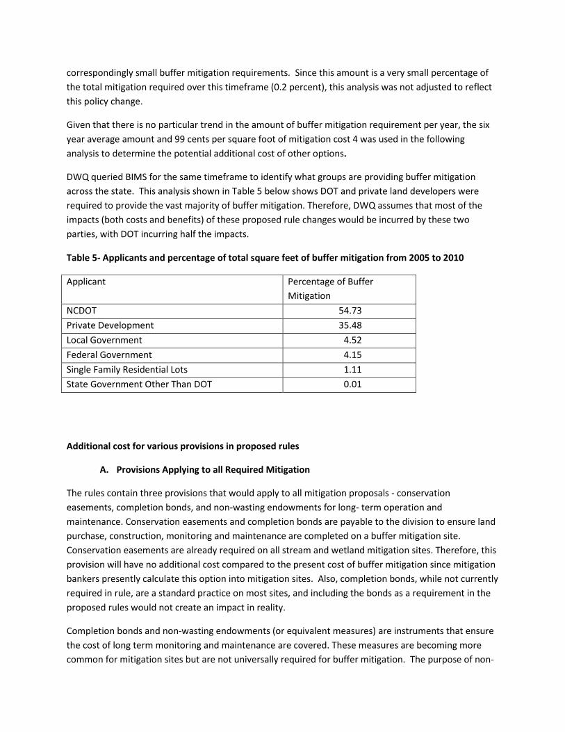
correspondingly small buffer mitigation requirements. Since this amount is a very small percentage of
the total mitigation required over this timeframe (0.2 percent), this analysis was not adjusted to reflect
this policy change.
Given that there is no particular trend in the amount of buffer mitigation requirement per year, the six
year average amount and 99 cents per square foot of mitigation cost 4 was used in the following
analysis to determine the potential additional cost of other options.
DWQ queried BIMS for the same timeframe to identify what groups are providing buffer mitigation
across the state. This analysis shown in Table 5 below shows DOT and private land developers were
required to provide the vast majority of buffer mitigation. Therefore, DWQ assumes that most of the
impacts (both costs and benefits) of these proposed rule changes would be incurred by these two
parties, with DOT incurring half the impacts.
Table 5- Applicants and percentage of total square feet of buffer mitigation from 2005 to 2010
Applicant Percentage of Buffer
Mitigation
NCDOT 54.73
Private Development 35.48
Local Government 4.52
Federal Government 4.15
Single Family Residential Lots 1.11
State Government Other Than DOT 0.01
Additional cost for various provisions in proposed rules
A. Provisions Applying to all Required Mitigation
The rules contain three provisions that would apply to all mitigation proposals - conservation
easements, completion bonds, and non-wasting endowments for long- term operation and
maintenance. Conservation easements and completion bonds are payable to the division to ensure land
purchase, construction, monitoring and maintenance are completed on a buffer mitigation site.
Conservation easements are already required on all stream and wetland mitigation sites. Therefore, this
provision will have no additional cost compared to the present cost of buffer mitigation since mitigation
bankers presently calculate this option into mitigation sites. Also, completion bonds, while not currently
required in rule, are a standard practice on most sites, and including the bonds as a requirement in the
proposed rules would not create an impact in reality.
Completion bonds and non-wasting endowments (or equivalent measures) are instruments that ensure
the cost of long term monitoring and maintenance are covered. These measures are becoming more
common for mitigation sites but are not universally required for buffer mitigation. The purpose of non-
wasting endowments is to generate enough annual interest from the endowment to hire staff for
periodic visits to sites in the future to make certain that the buffers functioning to remove nutrients
from urban and rural stormwater runoff. The cost of non-wasting endowments varies from location to
location and with the level of required oversight so it is difficult to find a single number to represent the
cost of the non-wasting endowment. Based on estimates from the NC EEP and discussions with private
mitigation bankers in North Carolina, an average of no more than about three-percent of the overall
cost of mitigation seems reasonable. The endowment principle would be collected at the time of
payment to the EEP program, effectively raising the cost by three cents per square foot of mitigation.
Therefore requiring non-wasting endowments and completion bonds (or equivalent measures) could
add about $110,000 annually to the cost of buffer mitigation for whichever one is used by the applicant.
The division derived this figure by multiplying three cents by the average annual square feet of buffer
mitigation and the current cost of mitigation per square foot (3% × $.99 × 3,687,122 = $109,500).
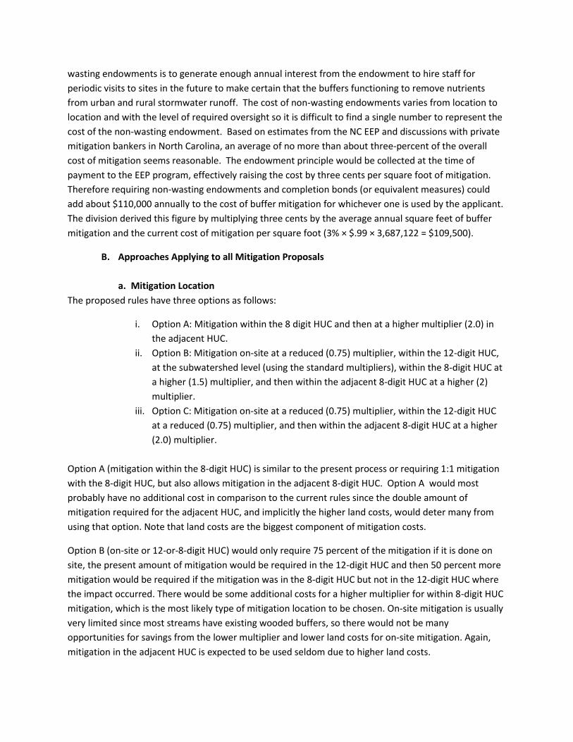
B. Approaches Applying to all Mitigation Proposals
a. Mitigation Location
The proposed rules have three options as follows:
i. Option A: Mitigation within the 8 digit HUC and then at a higher multiplier (2.0) in
the adjacent HUC.
ii. Option B: Mitigation on-site at a reduced (0.75) multiplier, within the 12-digit HUC,
at the subwatershed level (using the standard multipliers), within the 8-digit HUC at
a higher (1.5) multiplier, and then within the adjacent 8-digit HUC at a higher (2)
multiplier.
iii. Option C: Mitigation on-site at a reduced (0.75) multiplier, within the 12-digit HUC
at a reduced (0.75) multiplier, and then within the adjacent 8-digit HUC at a higher
(2.0) multiplier.
Option A (mitigation within the 8-digit HUC) is similar to the present process or requiring 1:1 mitigation
with the 8-digit HUC, but also allows mitigation in the adjacent 8-digit HUC. Option A would most
probably have no additional cost in comparison to the current rules since the double amount of
mitigation required for the adjacent HUC, and implicitly the higher land costs, would deter many from
using that option. Note that land costs are the biggest component of mitigation costs.
Option B (on-site or 12-or-8-digit HUC) would only require 75 percent of the mitigation if it is done on
site, the present amount of mitigation would be required in the 12-digit HUC and then 50 percent more
mitigation would be required if the mitigation was in the 8-digit HUC but not in the 12-digit HUC where
the impact occurred. There would be some additional costs for a higher multiplier for within 8-digit HUC
mitigation, which is the most likely type of mitigation location to be chosen. On-site mitigation is usually
very limited since most streams have existing wooded buffers, so there would not be many
opportunities for savings from the lower multiplier and lower land costs for on-site mitigation. Again,
mitigation in the adjacent HUC is expected to be used seldom due to higher land costs.

Option C would require less mitigation than the current rules if mitigation is performed on-site or within
the 12-digit HUC. Again, adjacent 8-digit HUC or on-site mitigation is expected to be very limited. In
addition, given fewer mitigation options available in smaller HUCs and the potentially higher cost to
perform mitigation in those HUCs, there might not be any savings from Option C versus what the current
requirements are.
Data on the availability of mitigation sites and on the location of mitigation sites relative to impact sites
are not readily available, so the following analysis is based on division staff’s professional judgment and
experience on buffer projects. Given the small size and relatively large number of 12-digit HUC units (for
instance, there are about seventy-five, 12-digit HUC’s in the Neuse and Tar-Pamlico basins in contrast to
the four 8-digit HUC’s in those basins) leads to staff to use best professional judgment to estimate that
mitigation in the 8-digit HUC would still be the norm with a few exceptions of on-site mitigation and
mitigation within the 12-digit HUC. The division also believes that Option A could be more expensive
than Options B and C due to the absence of the 12-digit HUC lower multiplier option for the rare cases
an applicant would have available sites for mitigation in the 12-digit HUC. Options B and C could be
cheaper having the 12-digit HUC lower multiplier option, and could lead to decreases in the total annual
cost, at the rate of $0.25 per square foot if mitigation is possible within the 12-digit HUC. Any additional
cost that are incurred from having higher multipliers for adjacent 8-digit HUCs would be offset by the
benefits the regulated party would incur (otherwise the adjacent 8-digit HUC would not be chosen).
Option B, however, due to the requirements of a higher multiplier for the 8-digit HUC than the current
rules, could increase annual costs by about $1,830,000 [= 0.5 × (about 3,690,000 sq ft of required
mitigation per year × 99 cents)].
Note that the proposed location mitigation options may have an indirect impact on property owners in
some parts of the state. To the extent that mitigation will be performed in sites with a higher location
multiplier, and depending on the land prices in the selected location, mitigation providers could incur
higher land related costs that would translate into benefits for property owners. Conversely, owners
may be negatively impacted if the overall size of areas of mitigation is smaller or mitigation is performed
on less expensive plots of land. Given the uncertainties related to which mitigation location language
will be chosen by EMC and what choices mitigation seekers will make as a result, it is difficult to
determine what the net impact to property owners may be, but it is likely to vary throughout the state.
The division feels there is no difference in the three location options in water quality benefits to the
estuary. However, these options might lead to changes in water quality upstream depending on the
amount of impact and mitigation, as well as hydrologic and geologic properties of some locations.
b. Accounting for buffer, nutrient offset and stream mitigation credit
Three credit accounting options are presented in the proposed rules. These options were developed
during a stakeholder meeting held in Raleigh on December 9, 2009. The division and EEP staff reviewed
these options in January 2011 and estimated the additional cost associated with the options. The cost
varied depending on whether stream restoration is needed on any particular site or whether simply
planting trees would suffice. For Option 2, the accounting that would be required by the division and
mitigation providers (including private bankers and the EEP) would be complex but possible. The
following costs were estimated for each option compared to the present approach that the division
uses.
Option 1- would allow the counting of both buffer and stream mitigation credits on a site. Nutrient
offset credits and buffer credits could not occur on the same site. Similarly, wetland mitigation credit
could not also be counted as buffer or nutrient offset credit. All of these procedures are consistent with
the process currently followed by the division so there is no additional cost associated with this option.
Option 2 - is an option that is a compromise between the way the division does business now with
buffer and stream mitigation (Option 1) and how some private mitigation bankers have voiced they
would like to see buffer and stream mitigation done (Option 3). Option 2 is preferred by several
environmental conservation groups and would allow buffer and stream mitigation at the same site if the
impact was to both streams and buffers. For instance, an impact from the construction of a road
crossing of a stream channel could do mitigation at a stream and buffer mitigation site. However, if the
impact was to buffers only (for instance for a sewer line that runs parallel to a stream rather than
crossing the stream), then mitigation would be at a buffer only site. Any stream mitigation credit
associated with that site would not be available for 401 Certification (the permit). This option could be
more expensive than the current practice since many buffer mitigation sites also require grading of the
landscape to create a stream channel and this cost could not be recovered from the site under this
proposed option. The higher cost also reflects the fact that the site costs could not be used to support
stream mitigation credit. Based on division and EEP staff estimates of the cost of mitigation and what
percent of buffer projects also require channel work, the division believes that this option would
increase costs at least 24 percent for a stable channel and 41 percent for an unstable channel. These
cost increases are based on staff’s professional knowledge of these practices. So, the estimated cost
increase would be between $880,000 and $1,500,000 [=24% or 41% × (about 3,690,000 sq ft of required
mitigation per year × 99 cents)]. Of the 39 buffer and nutrient offset mitigation projects done by the
EEP, only two (5 percent) required streambank work in addition to tree planting. Therefore, the actual
cost would be closer to the 24 percent increase rather than the 41 percent increase, and the 24 percent
cost increase assumption is used in this analysis. Furthermore, this option would also significantly
increase DENR’s staff time since buffer mitigation is currently tracked separately from stream and
wetland mitigation and reconciling the two would be difficult and time consuming. The Division is
unable to quantify at this time what the impact on staff time might be.
Option 3 - would not allow buffer mitigation to occur on sites where stream mitigation credits are
generated. This is a rather simple option to track with existing accounting systems but would greatly
increase the cost of mitigation. Division and EEP staff estimate based on best professional judgment
that this option would increase costs by about 41 percent for stable streams and 99 percent for unstable
streams since any work done on the channel could not be covered without raising mitigation fees. The
estimated impact would be an increase of between $ 1,500,000 and $3,600,000 [=41% or 99% × (about
3,690,000 sq ft of required mitigation per year × 99 cents)]. Since only 5 percent of the 39 buffer and
nutrient offset mitigation projects done by the EEP required streambank work in addition to tree
planting (i.e. were unstable stream projects), the actual cost increase would be closer to the 41 percent
rather than 99 percent, and the 41 percent cost increase assumption is used in this analysis.

C. Optional methods for buffer mitigation
The proposed rules also would create optional methods of buffer mitigation to allow the regulated
community greater flexibility and potentially lower the cost of compliance. The three categories of
methods include non-structural options, structural options and other options as approved by EMC. It is
unclear whether the availability of greater mitigation alternatives in itself would result in any significant
savings in terms of costs related to locating and securing a mitigation site.
a. Constructed Projects
The proposed rules would allow for buffer mitigation credit past the five-year monitoring period and
there are two options proposed for EMC’s consideration:
i. Option 1: Would allow for buffer mitigation projects constructed within the
required monitoring period as of the effective date of this Rule to be eligible for use
as alternative buffer mitigation. Projects that have completed monitoring and have
been released by the division as of the effective date of this Rule are not eligible for
use as alternative buffer mitigation.
ii. Option 2: Projects that have been constructed and are within the required
monitoring period on the effective date of this Rule are eligible to use alternative
buffer mitigation. Projects that have completed monitoring and have been released
by the division on or before the effective date of this Rule are eligible to use
alternative buffer mitigation for a period of ten years from the effective date of this
Rule.
There should be no change in cost or benefit from Option 1. Giving final mitigation credit at the end of
the five-year monitoring period is consistent with how buffer mitigation projects are currently handled.
Option 2 would allow for about three projects to be accepted for mitigation. The benefit to the
stakeholders (one by private industry and two by mitigation banks) would be approximately $3.4 million,
based on information they provided. This option is being requested by stakeholders that were installing
alternative buffer mitigation projects, but due to the length of time the rulemaking process is taking,
they will not get credit past the normal 5-year monitoring period.
The private industry project has 19.57 acres of buffer impact for which they need mitigation. The
mitigation required is 46.28 acres (Zone 1: 11.28 × 3 = 33.84 acres and Zone 2: 8.29 × 1.5= 12.44 acres).
Potential buffer credit, including the coastal headwater valleys they have already planted, is 100 acres.
Only 28 acres of buffer restored could be counted in accordance with the current rules. Therefore, 72
acres would be additional buffer credit if the proposed rules pass. This benefit cost would be 72 acres ×
43,560 sq ft × 99 cents = $3.1 million. If they can’t receive the coastal headwater valley credit, they
could only receive 28 acres of buffer mitigation credit which would be 28 acres × 43,560 × 99 cents =
$1.2 million.

Two mitigation banks seeking buffer mitigation credit for cattle exclusion measures they have already
undertaken have paid $305,000 ($115,000 for one bank and $190,000 for the other bank).
This net one-time benefit with the two banks ($115,000 + $190,000=305,000) and one private industry
project ($3.1 million) being able to gain credit for buffer mitigation currently not allowed in the rules
would equal $3.4 million.
b. Non-structural options
By creating more opportunities for the regulated community to perform mitigation themselves rather
than paying into the Riparian Buffer Restoration Fund or a mitigation bank, the proposed rule might lead
to the regulated community incurring more costs related to conservation easements (mostly related to
land costs ), completion bonds, and non-wasting endowments (see discussion above for the potential
cost of a non-wasting endowment). However, the regulated community also benefit from not paying the
Fund or mitigation bank fees. The potential cost and benefit associated with each of the new mitigation
options are presented below.
Coastal Headwater Wetland mitigation – This type of mitigation is somewhat cheaper than standard
stream mitigation since less engineering and site manipulation is needed. The EEP and a private
developer have each restored about five of these streams. Compared to traditional mitigation, coastal
headwater mitigation costs about 10 percent less according to these sources. The average cost for doing
this form of mitigation would be $0.89 per square foot. The division does not expect this form of
mitigation to be used often due to the fact it is limited to coastal buffered counties and the lack of
availability of coastal headwater wetlands.
Restoration of buffers along unmapped streams – The cost of this mitigation would be the same as
mitigation along mapped streams since the costs of design, land acquisition, planting, stream work, and
monitoring would be exactly the same. The advantage of this option is that it would expand the possible
number of buffer mitigation sites, which would allow some flexibility and perhaps decrease the time
spent on identifying a mitigation site. However, since the use of the two maps covers about 95 percent
of the stream length, the number of additional sites would be limited. The USGS topographic maps
underestimate streams on the coast but overestimate streams in the piedmont. Soil survey maps from
NRCS overestimate streams on the coast, but underestimate streams in the piedmont. Based on division
research, taking these two maps together as the current buffer rules require will provide a 95 percent
accuracy in locations of buffered streams in the buffered basins in North Carolina. With only 5 percent
of the overall streams in the buffered basins not being accurately shown on one of the two maps, the
division staff thinks very few projects will be able to utilize the restoration of unmapped streams option
in the proposed rules.
Preservation of stream buffers along unmapped streams –This option would allow the preservation of
buffers along unmapped streams at a 5:1 ratio along with 1:1 buffer restoration. This option would
again only be useful for stakeholders with large amounts of unmapped streams on their property, which
is a rare occurrence. A smaller number of streams would need to have a conservation easement and
non-wasting endowment since only 5 percent of the overall streams in the buffered basins could
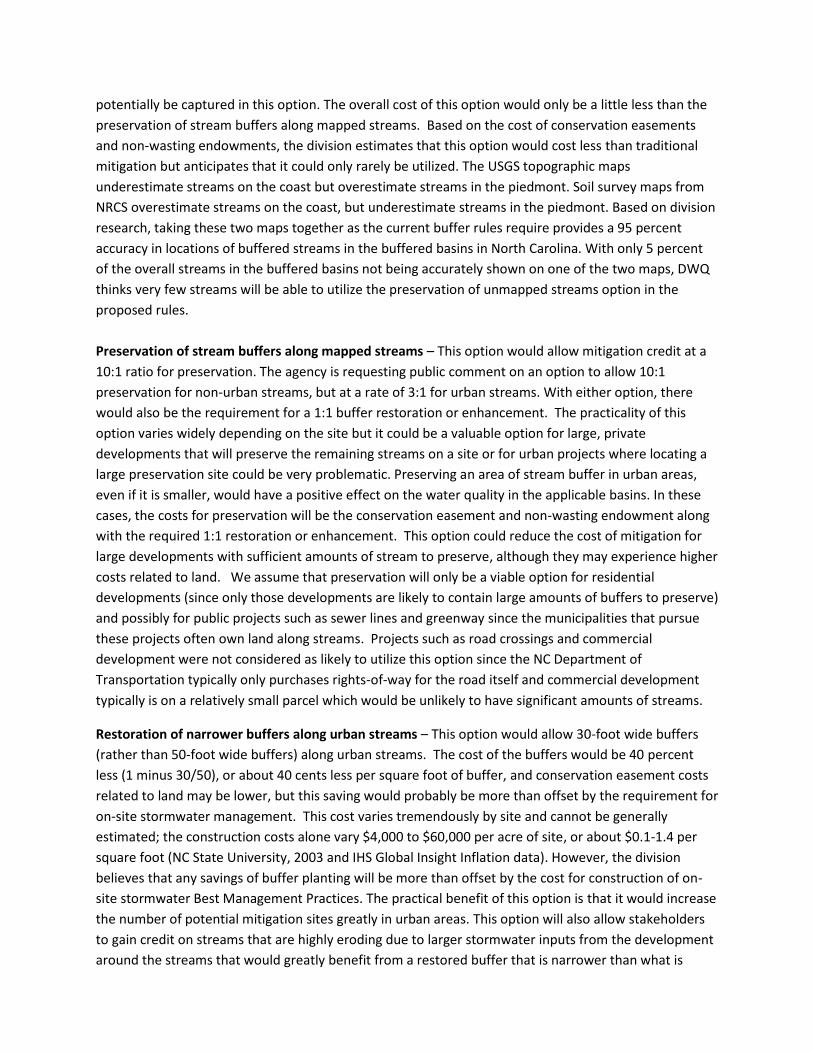
potentially be captured in this option. The overall cost of this option would only be a little less than the
preservation of stream buffers along mapped streams. Based on the cost of conservation easements
and non-wasting endowments, the division estimates that this option would cost less than traditional
mitigation but anticipates that it could only rarely be utilized. The USGS topographic maps
underestimate streams on the coast but overestimate streams in the piedmont. Soil survey maps from
NRCS overestimate streams on the coast, but underestimate streams in the piedmont. Based on division
research, taking these two maps together as the current buffer rules require provides a 95 percent
accuracy in locations of buffered streams in the buffered basins in North Carolina. With only 5 percent
of the overall streams in the buffered basins not being accurately shown on one of the two maps, DWQ
thinks very few streams will be able to utilize the preservation of unmapped streams option in the
proposed rules.
Preservation of stream buffers along mapped streams – This option would allow mitigation credit at a
10:1 ratio for preservation. The agency is requesting public comment on an option to allow 10:1
preservation for non-urban streams, but at a rate of 3:1 for urban streams. With either option, there
would also be the requirement for a 1:1 buffer restoration or enhancement. The practicality of this
option varies widely depending on the site but it could be a valuable option for large, private
developments that will preserve the remaining streams on a site or for urban projects where locating a
large preservation site could be very problematic. Preserving an area of stream buffer in urban areas,
even if it is smaller, would have a positive effect on the water quality in the applicable basins. In these
cases, the costs for preservation will be the conservation easement and non-wasting endowment along
with the required 1:1 restoration or enhancement. This option could reduce the cost of mitigation for
large developments with sufficient amounts of stream to preserve, although they may experience higher
costs related to land. We assume that preservation will only be a viable option for residential
developments (since only those developments are likely to contain large amounts of buffers to preserve)
and possibly for public projects such as sewer lines and greenway since the municipalities that pursue
these projects often own land along streams. Projects such as road crossings and commercial
development were not considered as likely to utilize this option since the NC Department of
Transportation typically only purchases rights-of-way for the road itself and commercial development
typically is on a relatively small parcel which would be unlikely to have significant amounts of streams.
Restoration of narrower buffers along urban streams – This option would allow 30-foot wide buffers
(rather than 50-foot wide buffers) along urban streams. The cost of the buffers would be 40 percent
less (1 minus 30/50), or about 40 cents less per square foot of buffer, and conservation easement costs
related to land may be lower, but this saving would probably be more than offset by the requirement for
on-site stormwater management. This cost varies tremendously by site and cannot be generally
estimated; the construction costs alone vary $4,000 to $60,000 per acre of site, or about $0.1-1.4 per
square foot (NC State University, 2003 and IHS Global Insight Inflation data). However, the division
believes that any savings of buffer planting will be more than offset by the cost for construction of on-
site stormwater Best Management Practices. The practical benefit of this option is that it would increase
the number of potential mitigation sites greatly in urban areas. This option will also allow stakeholders
to gain credit on streams that are highly eroding due to larger stormwater inputs from the development
around the streams that would greatly benefit from a restored buffer that is narrower than what is
currently allowed in the buffer mitigation rules. Overall, the division thinks this option would not be
cheaper than traditional mitigation. Stakeholders have stated during the policy development process
that having this option is necessary for areas where this may be the only option for obtaining buffer
mitigation credit. This is an indication that stakeholders value the benefit of having a greater number of
developable sites more than the potential increase in cost.
Sewer Easements – The proposed rule would allow for some credit to be gained from properties where
there is a sewer easement.
Option 1: The portion of the sewer easement located in Zone 1 or Zone 2 of the buffers could
not be counted towards buffer mitigation credit. This is due to the fact that per the current
buffer mitigation rules and this proposed rule, in order to obtain mitigation credit you must
plant the buffer. However, under the proposed rule, the applicant may get narrower buffer
credit in accordance with (k)(2)(D) of this rule.
Option 2: If the proposed mitigation site contains a sewer easement, the portion of the
easement located within Zone 1 will not be for buffer mitigation credit, but credit would be
granted for a dedicated sewer easement in Zone 2 buffer if:
1. the sewer easement is at least 30 feet wide, and
2. the sewer easement is maintained in a condition which meets the vegetative
requirements of the collection system permit, and
3. the applicant will restore or enhance the forested buffer in Zone 1 adjacent to the
sewer easement.
The sewer easement option would benefit stakeholders, especially municipalities, who maintain sewer
lines in protected riparian buffers. Allowing this option would increase mitigation options and would
result in lower mitigation costs for these stakeholders. However, this relaxation of the Zone 1 forested
buffer required in the current buffer rule will result in weakened protection of the estuary. This means
there would be diminished public water quality benefits associated with this option.
Using data from 2005-2010 in the BIMS database, division staff calculated that there were 41 utility line
projects (water or sewer lines) that required buffer mitigation totaling 496,312 square feet of required
buffer mitigation. This could equate to a benefit to municipalities of $491,000 (496,312 square feet × 99
cents) of buffer mitigation if Option 2 is chosen.
Enhancement of grazing areas – This option would allow grazed areas with scattered trees to be
counted as buffer restoration or enhancement at a 2:1 ratio. The cost of this option would be about
double the cost of traditional mitigation since the only cost that would not have to be borne by the
mitigation would be to lower the cost of planting depending on the site. Fencing would be the notable
extra cost associated with this use. However, this option would again increase the number of potential
mitigation sites. Costs associated with this use would be approximately $1.20 a linear foot per Soil and
Water Conservation Program estimates. An estimate on how much this would add to a project is
unknown due to the variability in the size of the mitigation projects.

c. Structural options
Structural options allowed by this proposed rule include constructed wetlands, bio-retention facilities,
infiltration devices and wet ponds followed by wooded filter strips. The costs of these facilities are (in
general) much higher than the simple planting of trees along un-wooded stream channels. In addition,
the cost of designing, constructing and operating constructed wetlands can be highly variable (Hathaway
and Hunt 2007, Virginia Water Resources Research Center 2011). It is not clear how large a constructed
wetland would have to be to be used in place of planting a wooded buffer along streams since the rules
require that the proponent get EMC approval for the calculation method for the particular site. In
general, the division thinks that structural options would likely be more expensive than traditional buffer
mitigation but that the exact cost would vary from site to site. The lower cost estimate for this option is
estimated to be $91,000 (Hathaway and Hunt 2007, Virginia Water Resources Research Center 2011).
The main advantage of this option is that it would increase the number of potential mitigation options in
locations where such choices may become limited (such as in urban areas or locations such as Tar-
Pamlico 04 and 05 where stream densities are naturally low). Therefore, there would be a time savings
to the stakeholders due to the increased mitigation options. The division asked several stakeholders to
place a value on this option. Several developers stated that having this as an option could greatly cut
planning costs on larger projects where the amount of available buffer mitigation could be very limited
or scarce. In situations where this option is used, stakeholders are willing to pay for structural options
and anticipate this option’s benefits are equal to or greater than the costs.
Other options as approved by the EMC – This provision in the rule would allow a stakeholder or
mitigation provider to propose another type of buffer mitigation that neither the division nor the
stakeholders have anticipated to date. Since this option is so broad, an estimate of the cost of this
option is not possible until the exact option is proposed to the EMC. Presumably, a stakeholder or
mitigation provider would only propose a less expensive option when compared to traditional mitigation
if traditional mitigation options were still available in a certain area. This option could cost division staff
time to review and prepare a presentation to the EMC for approval. Costs associated with staff time
would be dependent on how often these other options were being proposed by stakeholders. The
division does not expect other options to be used often, so costs should be minimal.
The impact discussion above those not account for the fact that providing additional opportunities for
mitigation might result in the regulated community building more projects that require buffer mitigation
than before. Additionally, while some of the options above are estimated to increase the cost of
mitigation, it is assumed that any person that opts for that method of mitigation is deriving an additional
benefit that is at least equal to the additional cost estimated.

IV. Water Quality Benefits of Riparian Buffers
Riparian buffers have been well documented to provide crucial water quality benefits including
transformation and removal of nutrients, removal of sediment, removal of toxicants such as heavy
metals, removal of pathogens such as bacteria and viruses, provision of shade for in-stream temperature
control, stabilization of stream banks, and provision of leaves and woody material to stream channels
for aquatic life support. The extensive scientific research done in North Carolina and across the world
has made it clear that a wooded buffer is essential to the health of the aquatic ecosystem of the
adjacent water. Some of this research is summarized below. Because the water quality benefits of
buffers vary greatly from site to site, quantification of these benefits into dollar values is challenging. In
addition, these benefits will only be potentially realized at the estuary point in instances when the
proposed rule change increases the total amount of buffers. Also, in areas where buffer mitigation is no
longer available, such as in Tar-Pamlico 04 and 05 HUC, nutrients to the Tar-Pamlico estuary could
increase. The hope with these proposed rules is to allow for more options, other than planting a buffer,
to counter any increases in nutrients to the estuaries for those who are running into this problem of no
viable buffer restoration sites.
Nutrient transformation and removal – Riparian buffers can remove significant amounts of nitrogen
and phosphorus and thereby protect downstream waters from eutrophication. For instance, Mayer, et
al .(2007) conducted an extensive review of the scientific literature on the removal of nitrogen by
riparian buffers and provided a regression equation to predict the removal of total nitrogen by various
widths of riparian buffers. His work found that a 50-foot wide buffer removed about 70 percent of the
total nitrogen entering the buffer through stormwater. Similarly, for phosphorus, research has shown
riparian buffers have significant reductions in phosphorus levels in stormwater runoff (Wenger 1999)
with a 9 meter (30-foot) wide buffer removing 46 to 79 percent of total phosphorus.
Sediment removal – Riparian buffers can remove significant amounts of sediment. For instance, Dillaha,
et al. (1988) found that even a fairly narrow buffer of 15 feet was able to remove 76 to 87 percent of
sediment. Wider buffers (30 feet) were more effective and removed from 88 to 95 percent of sediment
depending on slope. On steeper slopes, wider buffers are probably needed but in general, the 50-foot
buffer required by state riparian buffer rules will remove the vast majority of sediment.
Toxicant removal – Buffers remove significant amounts of toxicants such as heavy metals or organic
pollutants found in stormwater runoff. Wenger (1999) summarized various publications and based on
the limited data available in the scientific literature, concluded that buffers at least 50-feet wide are
needed with wider buffers on steeper slopes.
Pathogen removal – Buffers can remove significant amounts of these pathogens – bacteria and viruses
from stormwater. For instance, Trask, et al (2004) reported that buffers were very effective in removing
Cryptosporidium parvum from simulated runoff. Similarly, Collins, et.al. (2004) found that fecal bacteria
(Escherichia coli and Campylobacter) were removed by buffer strips and concluded that buffers of at
least 15-feet in width were needed to markedly reduce the levels of fecal bacteria in simulated runoff.
Finally, Stout, et al. (2005) examined runoff transport of fecal coliforms from manure and concluded
that buffers can remove significant amounts of these pollutants. In general, it is clear that buffers such

as those required by the state’s riparian buffer rules can remove significant amounts of bacteria from
stormwater runoff.
Provision of shade – Wooded riparian buffers can significantly reduce stream temperatures during the
hot, summer months. Wenger (1999) that a width of at least 30-feet was important for temperature
control. Researchers in Georgia (Jones, et al 2006) examined the importance of wooded buffers to trout
populations in the Appalachian Mountains in Georgia. They concluded that streams with 50-foot wide
buffers had higher temperatures than those with 100-foot wide buffers with a predicted 66 to 97
percent reduction in trout populations in streams with the narrower buffers.
Stabilization of stream banks – Wooded buffers have significant effect on stabilizing stream banks and
preventing their erosion and impact on downstream waters. Wenger (1999) concluded that buffer
widths sufficient for other purposes should also be sufficient to prevent stream bank erosion.
Therefore, the 50-foot state riparian buffer width should have significant benefits in stabilizing
streambanks.
Provision of leaves and woody debris- Woody debris and trees leaves are essential inputs of energy and
nutrients into streams since they (and the bacteria and fungi growing on them) provide food for aquatic
insects which are the base of the aquatic food chain. Little research has been done on the width needed
to provide this essential function but research reported from the piedmont of North Carolina (Dorney,
personal communication, September 23, 2011) showed that about 95 percent of tree leaves in forested
riparian buffers fall within 50-feet of the stream channel. Therefore once again, the 50-foot state
riparian buffer width should have significant benefits in providing leaves to stream ecosystems
It is clear that wooded riparian buffers are essential to healthy streams and provide essential and highly
beneficial effects on water quality. In fact, it can be stated from this work that without wooded buffers
along streams, water quality will dramatically decrease. A study done concerning lake water quality in
the United States (Kramer, et al. 2006) concluded that riparian buffers were a more cost effective way
than retrofitting a stormwater best management practice to address phosphorus which resulted in
decreased lake water quality in 24 of the 25 lakes studied. Protection and restoration of wooded buffers
provides a significant economic benefit to water quality since they can be used in place of more
expensive water treatment measures.
Assuming that the cost of nutrient removal provides a lower bound estimated of the value placed on
nutrient reduction, the Division used information from the NCEEP program to estimate some of these
benefits in monetary terms.
The North Carolina EEP nutrient offset credit rate is $18.49/lb for nitrogen (N) and $142.02/lb for
phosphorus (P). EEP Estimates that over a 30-year period, one acre of forested riparian buffer prevents
2,273 lbs-N and 146.4 lbs-P from reaching surface waters. Therefore, assuming constant removal cost
rates, one acre of forested riparian buffer has a value of: $18.49/lb X 2,273 lbs-N-30 years =
$42,027.77 and $142.02/lb X 146.4 lbs-P-30 years = $20,793.19.
Wooded riparian buffers provide both ecosystem services through different mechanisms. The combined
nutrient removal value for one acre of restored forested riparian buffer over a 30-year period is
$62,820. The price for a riparian buffer mitigation credit through North Carolina EEP Is $0.99/square
foot, which translates to $43,124/acre. Assuming the value placed on water quality is mimicked by the
costs EEP incurs to remove nitrogen and phosphorous, the net benefit of an acre of riparian buffer
would be about $20,000 over a 30-year period. Given all the options available to the regulated
community, it is unclear how many more acres of riparian buffers would result from the proposed rule
change.
From the non-structural options that the proposed rule present, the most likely to be employed is the
narrower buffers along urban streams, where projects would receive either partial credit or be required
to build some stormwater BMPs. While it is unclear whether cost savings from the narrower buffer
offset the BMP costs, there is some indication that the public benefits from restoration and BMP would
surpass the costs. A 2004 study along the Little Tennessee River found that the benefit cost ratio for
riparian restoration plus a BMP ranged from about 4 for 2 miles of restoration to 16 for 6 miles of
restoration (Holmes et. al., 2004).
While water quality in the estuary is not expected to deteriorate, there may be undesired effects in
certain locations where the mitigation would be further away from the impact, or may be provided in a
form that is not as efficient at providing the same water quality benefits given the geological and
hydrological properties of the location. A study on two different sections of buffer on the same stream
showed the two sections performed differently despite being in close proximity to one another (Messer
et. al., 2012).
V. Summary of Costs and Benefits for Proposed Rules.
The impacts of various options outlined in the rules are described above. These costs are summarized in
Tables 6 through 8 below.
The overall cost and benefit of these flexible buffer mitigation rules will vary across the state depending
on construction and land costs as well as the availability of traditional buffer mitigation sites. Perhaps
the area of the state where these options will be most useful is in coastal plain locations such as Tar-
Pamlico 04 and 05 area. This 8-digit HUC is centered on the Washington, NC area and (as is typical of
coastal plain areas) is naturally characterized by few streams. In addition, these streams usually have
wooded buffers since the buffer areas are often riparian wetlands and too wet for agriculture. For these
reasons, locating traditional buffer mitigation sites in this area has become problematic. The availability
of these options will provide an expanded list of buffer mitigation possibilities needed to compensate
for unavoidable buffer impact for important development activities such as roadway improvements.

Table 6 – Summary of Annual Costs of Various Options in the Proposed Rules compared to the 2005 –
2010 Baseline: Provisions that would apply to all buffer mitigation options
Item Description of option Percent
increase in
cost
Estimated additional annual cost
or benefit
Conservation
easement
Agreement that limits
use of land
0 percent Zero additional cost-already
required for mitigation sites
Completion
bonds
Financial agreement
that insures a project
has the money to be
completed
0 percent Zero additional cost-already
standard practice for mitigation
sites
Non-wasting
endowment
Agreement so funds are
available for periodic
site visits to insure
buffers are functioning
3 percent $110,000 estimated annual cost-
not universally required for buffer
mitigation sites
Table 7 - Summary of Annual Costs of Various Options in the Proposed Rules compared to the 2005
– 2010 Baseline: Approaches in the Rules which would apply to all mitigation proposals.
Item Description of option Percent
increase in cost
Estimated additional annual cost
or benefit
Mitigation Location
Option A
8-digit HUC 0 percent Zero additional cost or benefit
Option B
On-site followed by
12-digit HUC as
standard area and 8-
digit HUC with 1.5
multiplier
Up to 50
percent
increase due to
1.5 multiplier
for 8-digit HUC
$1,830,000 of additional annual
cost; some benefit from reduced
ratio for mitigation in the 12 digit
HUC
Option C
On-site followed by
12-digit HUC as
standard area and 8-
digit HUC with 1.0
multiplier
Unclear Zero additional cost for those
mitigating in 8-digit HUC; some
benefit from reduced ratio for
mitigation in the 12 digit HUC but
might be offset by higher cost
and fewer mitigation options

Item Description of option Percent
increase in cost
Estimated additional annual cost
or benefit
Accounting for
buffer, nutrient
offset and stream
mitigation credit
Option 1 – No
restriction on
accounting
0 percent Zero additional cost or savings.
This option is currently how
division handles buffer and
stream mitigation
Option 2 – align
impacts with
mitigation
24 percent
annual increase
$880,000 of additional annual
cost; plus additional DENR staff
time
Option 3 – disallow
buffer credit on
stream mitigation sites
41 percent
annual increase
$1,500,000 of additional annual
cost
Mitigation credit
for alternative
measures
Option 1 Credit after five- year
monitoring period
release
0 percent
Would be a
benefit with
additional
options gaining
credit
No additional cost
Option 2 Credit up to ten years
from effective date of
the rule
0 percent Could be up to $3.4 million in
additional benefits (one- time
benefit)
Table 8 - Summary of Annual Costs of Various Options in the Proposed Rules compared to the 2006 –
2010 Baseline: Optional methods of buffer mitigation allowed in the proposed rules
Item Description of option Percent
increase in cost
Estimated additional annual cost
or benefit
Non-structural
options
Coastal headwater
stream mitigation
-10 percent 10 percent cheaper than current
methods
Restoration of buffers
along unmapped
streams
0 percent
There will be no additional costs
and more sites will be available
for mitigation. There is a time
savings by stakeholders being
able to gain credit for restoring
buffers on streams not mapped
on their property
Item Description of option Percent
increase in cost
Estimated additional annual cost
or benefit
Preservation of
buffers along
unmapped streams
Slightly less
costly than
traditional
mitigation.
This option will lower costs but
can seldom be used since
unmapped streams ( 5 percent of
total) could use this option.
Preservation of
buffers along mapped
streams
Less costly than
traditional
mitigation.
There would be more
opportunities to perform
mitigation saving stakeholders
time to identify a mitigation area,
as well as a small cost difference
between this option and
traditional mitigation.
Restoration of
narrower buffers
along urban streams
Variable and
cannot be
determined
since the higher
cost of the
required on-site
stormwater
management
may or may not
offset the lower
cost associated
with a narrower
buffer.
Overall cost implications will be
site specific and this option will
increase the number of sites
available for mitigation
Sewer Easement
Mitigation Credit:
Option 1:
No credit for grassed
easements in the
buffer
No increase No increase
Option 2:
Credit for grassed
easements in the
buffer
Could lead to
increased
nutrient run-off
to the estuaries
due to less
forested buffers
$491,000 benefit for
municipalities
Enhancement of
grazed areas
Costs $1.20 per
linear foot
This method would be double the
cost of traditional methods but
would increase the number of
available sites.

Item Description of option Percent
increase in cost
Estimated additional annual cost
or benefit
Structural options Various options
including constructed
wetlands,
bioretention, and
infiltration devices
Cost of
structural
options are
substantially
higher than
standard buffer
mitigation.
This method is more costly but
will increase the number of
mitigation sites. These solutions
may work in situations where
projects would be unable to
proceed otherwise.
Other options as
approved by the
EMC
Any such option
would be
proposed by
stakeholders or
mitigation
providers and
presumably
would only be
proposed if it
were less
expensive than
traditional
mitigation.
N/A
Water Quality
Benefits
None If rule change results in more
acres of riparian buffer, there
could be a benefit of about
$20,000 over 30 years.
Based on this analysis, staff thinks these proposed rules will not be cost prohibitive and will have a net
benefit to stakeholders by allowing them to construct projects the current buffer mitigation rules
prohibit. Local governments and state facilities are subject to these costs whenever buffer mitigation is
required for their projects.
VI. Threshold Decision After Preliminary Rules Evaluation
The total cost of this rule package depends on the specific options selected by the EMC and the actions
of future permit applicants. With certainty, annual costs will increase by about $110,000 for the creation
of non-wasting endowments. These costs will be proportional to the number of mitigation credits each
project needs to purchase. One action the EMC is considering would be to reduce the mitigation area
from an 8-digit HUC to the 12-digit HUC. The division estimates that this change, in addition to the non-
wasting endowment, would increase costs by $1,830,000. There are three different options for buffer

mitigation accounting. If Option 1 is selected, costs will not increase. Selection of Option 2 would result
in additional estimated costs between $880,000 and $1,500,000 each year, although the lower estimate
is more likely. Option 3 would be the most costly option and result in a range of annual estimated cost
increase between $1,500,000 to $3,600,000, although the lower estimate is more likely. The following
chart depicts the flow of decisions and known costs.
We do not know if stakeholders will use these methods, the frequency of use or the scope of future
projects. However, general economic theory asserts that if a site developer chooses to use one of these
options, then to that individual, the increased cost is lower than the expected project benefits. Projects
undertaken using optional mitigation options would result in a net benefit of undetermined value.
Some of the benefits from these proposed rule changes are quantifiable such as the $3.4 million dollar
benefit for extending the timeline for alternative mitigation credit, $490,000 for sewer easement credit
and other benefits have values that we are unable to estimate. The greatest benefit of these rule
changes is that they will give land developers, local governments, and state agencies such as DOT, more
ways to perform mitigation and to find acceptable mitigation sites closer to the impacted site. Projects
that may not have been possible to develop in the past will now be more feasible. In general, these
options will provide valuable options for stakeholders and mitigation providers in situations where
traditional mitigation options are scarce or exhausted. In those instances, the provision of these options
would allow important development to proceed, which otherwise would be prevented from occurring
by the lack of compensatory mitigation. If these options lead to an increase in buffer preservation, the
Cost of Nonwasting Endowment:
$110,000
Cost of Mitigation without Change to HUC (Option A and
C): $110,000
Option 1: $110,000
Option 2: $990,000
Option 3: $1,610,000
Cost of Mitigation with Change to HUC (Option
B): $1,940,000
Option 1: $1,940,000
Option 2: $2,820,000
Option 3: $3,440,000
public will experience some or all of the benefits presented in section IV. DENR does not have enough
data and information to be able to provide any significant estimates for the number of additional
projects that would be built as a result of having additional mitigation options.
VII. Uncertainties in Analysis
The main source of uncertainty in this analysis is the number of options available for particular choices
as well as the inherently variable cost of land and applicability of specific options for specific sites. Once
the EMC conducts public hearings and then narrows the options, there will be more information to
inform a more precise estimate of the cost of these rules. Through the public hearing process,
stakeholder will comment on the options presented in this analysis to assist the EMC in selecting final
rule language. This rule package was designed with several different alternative courses of action. This
fiscal note has investigated the potential cost and benefits associated with different options. The
Environmental Management Commission will make a final determination on the actual proposed rule
language after these alternatives are taken out for public comment.
If this proposed mitigation rule is not initiated, then projects in certain HUCs will not be allowed to be
constructed. Currently, applicants are able to build their projects in most HUCs, but some HUCs such as
Tar-Pam 04 and 05 do not have available buffer restoration sites and therefore there are no viable
buffer mitigation sites. The inability to meet the mitigation per the current buffer rules could cost the
state jobs with the projects failure to build per the current buffer mitigation rules.
If this proposed mitigation rule is passed, then more buffer impact projects could be permitted.
However, the division does not think that water quality would be reduced to these estuaries. Per this
rule, buffers would be restored in areas where a buffer does not currently exist and other alternative
options could be used that would replace the functions of the buffer that may be removed with the
permitted buffer projects.
There is an uncertainty of the actual square feet of buffer mitigation required from 2005-2010 because
the data that was used in this analysis does include data prior to the recession that the United States is
currently experiencing.
Structural options are new to the rule so it will be difficult to place a cost or benefit to these.
In the beginning these options may be more expensive than currently used restoration, but these could
ultimately become cheaper over time with more applicants using these or other alternative options.

References
a. Collins, R, A. Donnison, C.Ross and M. McLEod, 2004. Attenuation of effluent-derived
faecal microbes in grass buffer strips. New Zealand Journal of Agricultural Research
47:565-574.
b. Dillaha, T.A., J.H. Sherrod, D. Lee, S. Mostaghimi, and V. O. Shanholtz. 1988. Evaluation of
vegetative filter strips as a best management practice for feed lots. Journal of the Water
Pollution Control Federation 60(7):1231-1238.
c. Hathaway, J and W. Hunt. 2007. Stormwater BMP costs. N.C. State University.
http://www.bae.ncsu.edu/stormwater/PublicationFiles/DSWC.BMPcosts.2007.pdf
d. Holmes, T.P., Bergstrom, J.C., Huszar, E., Kask, S.B. and Orr, F. 2004. Contingent
valuation, net marginal benefits, and the scale of riparian ecosystem restoration.
Ecological Economics 49: 19– 30.
e. Jones. K.L., G.C. Poole, J.L.Meyer, W. Bumback and E.A. Kramer. 2006. Quantifying
expected ecological response to natural resource legislation: a case study of riparian
buffers, aquatic habitat and trout populations. Ecology and Society 11(2):15.
f. Kramer, D.B., S. Polasky, A. Starfield, B. Palik, L. Westphal, S. Snyder, P, Jakes, R. Hudson,
and E. Gustafson. 2006. A comparison of alternative strategies for cost-effective water
quality management in lakes. Environmental Management 38 (3):411-425.
g. Mayer,P.M., S.K. Reynolds, M.D. McCutchen and T.J. Canfield. 2007. Meta-Analysis of
Nitrogen Removal in Riparian Buffers. Journal of Environmental Quality 36(4):1172-1190.
h. Messer, T.L., Burchell, M.R., Grabow, G.L., and Osmond, D.L. 2012. Groundwater nitrate
reductions within upstream and downstream sections of a riparian buffer. Ecological
Engineering 47: 297– 307
i. NC State University. An Analysis of Cost and Benefits of Structural Stormwater Best
Management Practices in North Carolina. 2003.
http://www.bae.ncsu.edu/people/faculty/hunt/bmpcosts&benefits.pdf
j. Palmer Land Trust. Conservation Easement Costs. http://palmerlandtrust.org/land-
conservation-tools/conservation-easements/conservation-easement-costs
k. Stout, W.L., Y.A. Pachepsky, D.R. Shelton, A. M. Sadeghi, L:.S. Saporito and A.N. Sharpley.
2005. Runoff transport of faecal coliforms and phosphorus released from manure in grass
buffer conditions. Letters in Applied Microbiology 41:230-234.
l. Trask, J.R., R.K. Kalita, M.S. Kuhlenschmidt, R.D. Smith and T.L. Funk. 2004. Overland and
near-surface transport of Cryptosporidum parvum from vegetated and nonvegetated
surfaces. Journal of Environmental Quality 33:984-993.
m. Virginia Water Resources Research Center. 2011. Virginia Stormwater BMP
Clearinghouse. http://vwrrc.vt.edu/swc/BMPCosts.html
n. Wenger, S. 1999. A review of the scientific literature on riparian buffer width, extent and
vegetation. Office of Public Service and Outreach, Institute of Ecology, University of
Georgia. Athens, GA.

Appendix
15A NCAC 02B .0242 NEUSE RIVER BASIN: NUTRIENT SENSITIVE WATERS MANAGEMENT
STRATEGY: MITIGATION PROGRAM FOR PROTECTION AND
MAINTENANCE OF EXISTING RIPARIAN BUFFERS
The following are the requirements for the Riparian Buffer Mitigation Program for the Neuse Basin.
(1) PURPOSE. The purpose of this Rule is to set forth the mitigation requirements that apply to the Neuse
Basin existing riparian buffer protection program, as described in Rule 15A NCAC 2B .0233.
(2) APPLICABILITY. This Rule applies to persons who wish to impact a riparian buffer in the Neuse
Basin when one of the following applies:
(a) A person has received an Authorization Certificate pursuant to 15A NCAC 2B .0233 for a
proposed use that is designated as "allowable with mitigation."
(b) A person has received a variance pursuant to 15A NCAC 2B .0233 and is required to perform
mitigation as a condition of a variance approval.
(3) THE AREA OF MITIGATION. The required area of mitigation shall be determined by either the
Division or the delegated local authority according to the following:
(a) The impacts in square feet to each zone of the riparian buffer shall be determined by the
Division or the delegated local authority by adding the following:
(i) The area of the footprint of the use causing the impact to the riparian buffer.
(ii) The area of the boundary of any clearing and grading activities within the riparian
buffer necessary to accommodate the use.
(iii) The area of any ongoing maintenance corridors within the riparian buffer associated
with the use.
(b) The required area of mitigation shall be determined by applying the following multipliers to
the impacts determined in Sub-item (3)(a) of this Rule to each zone of the riparian buffer:
(i) Impacts to Zone 1 of the riparian buffer shall be multiplied by 3.
(ii) Impacts to Zone 2 of the riparian buffer shall be multiplied by 1.5.
(iii) Impacts to wetlands within Zones 1 and 2 of the riparian buffer that are subject to
mitigation under 15A NCAC 2H .0506 shall comply with the mitigation ratios in
15A NCAC 2H .0506.
(4) THE LOCATION OF MITIGATION. The mitigation effort shall be the same distance from the Neuse
River estuary as the proposed impact, or closer to the estuary than the impact, and as close to the
location of the impact as feasible.
(5) ISSUANCE OF THE MITIGATION DETERMINATION. The Division or the delegated local
authority shall issue a mitigation determination that specifies the required area and location of
mitigation pursuant to Items (3) and (4) of this Rule.
(6) OPTIONS FOR MEETING THE MITIGATION DETERMINATION. The mitigation determination
made pursuant to Item (5) of this Rule may be met through one of the following options:
(a) Payment of a compensatory mitigation fee to the Riparian Buffer Restoration Fund pursuant to
Item (7) of this Rule.
(b) Donation of real property or of an interest in real property pursuant to Item (8) of this Rule.
(c) Restoration or enhancement of a non-forested riparian buffer. This shall be accomplished by
the applicant after submittal and approval of a restoration plan pursuant to Item (9) of this
Rule.
(7) PAYMENT TO THE RIPARIAN BUFFER RESTORATION FUND. Persons who choose to satisfy
their mitigation determination by paying a compensatory mitigation fee to the Riparian Buffer
Restoration Fund shall meet the following requirements:
(a) SCHEDULE OF FEES: The amount of payment into the Fund shall be determined by
multiplying the acres or square feet of mitigation determination made pursuant to Item
(5) of this Rule by ninety-six cents per square foot or forty-one thousand, six hundred and
twenty-five dollars per acre.
(b) The required fee shall be submitted to the Division of Water Quality, Wetlands Restoration
Program, MAIL SERVICE CENTER 1619, RALEIGH, NC 27699-1619 prior to any
activity that results in the removal or degradation of the protected riparian buffer for
which a "no practical alternatives" determination has been made.
(c) The payment of a compensatory mitigation fee may be fully or partially satisfied by donation
of real property interests pursuant to Item (8) of this Rule.
(d) The Division shall review the fee outlined in Sub-item (7)(a) of this Rule every two years and
compare it to the actual cost of restoration activities conducted by the Department,
including site identification, planning, implementation, monitoring and maintenance
costs. Based upon this biennial review, the Division shall recommend revisions to Sub-
item (7)(a) of this Rule when adjustments to this Schedule of Fees are deemed necessary.
(8) DONATION OF PROPERTY. Persons who choose to satisfy their mitigation determination by
donating real property or an interest in real property shall meet the following requirements:
(a) The donation of real property interests may be used to either partially or fully satisfy the
payment of a compensatory mitigation fee to the Riparian Buffer Restoration Fund
pursuant to Item (7) of this Rule. The value of the property interest shall be determined
by an appraisal performed in accordance with Sub-item (8)(d)(iv) of this Rule. The
donation shall satisfy the mitigation determination if the appraised value of the donated
property interest is equal to or greater than the required fee. If the appraised value of the
donated property interest is less than the required fee calculated pursuant to Sub-item
(7)(a) of this Rule, the applicant shall pay the remaining balance due.
(b) The donation of conservation easements to satisfy compensatory mitigation requirements shall
be accepted only if the conservation easement is granted in perpetuity.
(c) Donation of real property interests to satisfy the mitigation determination shall be accepted
only if such property meets all of the following requirements:
(i) The property shall be located within an area that is identified as a priority for
restoration in the Basinwide Wetlands and Riparian Restoration Plan developed
by the Department pursuant to G.S. 143-214.10 or shall be located at a site that
is otherwise consistent with the goals outlined in the Basinwide Wetlands and
Riparian Restoration Plan.
(ii) The property shall contain riparian buffers not currently protected by the State's
riparian buffer protection program that are in need of restoration.
(iii) The restorable riparian buffer on the property shall have a minimum length of 1000
linear feet along a surface water and a minimum width of 50 feet as measured
horizontally on a line perpendicular to the surface water.
(iv) The size of the restorable riparian buffer on the property to be donated shall equal or
exceed the acreage of riparian buffer required to be mitigated under the
mitigation responsibility determined pursuant to Item (3) of this Rule.
(v) The property shall not require excessive measures for successful restoration, such as
removal of structures or infrastructure. Restoration of the property shall be
capable of fully offsetting the adverse impacts of the requested use;
(vi) The property shall be suitable to be successfully restored, based on existing
hydrology, soils, and vegetation;
(vii) The estimated cost of restoring and maintaining the property shall not exceed the
value of the property minus site identification and land acquisition costs.

(ix) The property shall not contain any building, structure, object, site, or district that is
listed in the National Register of Historic Places established pursuant to Public
Law 89-665, 16 U.S.C. 470 as amended.
(x) The property shall not contain any hazardous substance or solid waste.
(xi) The property shall not contain structures or materials that present health or safety
problems to the general public. If wells, septic, water or sewer connections exist,
they shall be filled, remediated or closed at owner's expense in accordance with
state and local health and safety regulations.
(xii) The property and adjacent properties shall not have prior, current, and known future
land use that would inhibit the function of the restoration effort.
(xiii) The property shall not have any encumbrances or conditions on the transfer of the
property interests.
(d) At the expense of the applicant or donor, the following information shall be submitted to the
Division with any proposal for donations or dedications of interest in real property:
(i) Documentation that the property meets the requirements laid out in Sub-Item (8)(c) of
this Rule.
(ii) US Geological Survey 1:24,000 (7.5 minute) scale topographic map, county tax map,
USDA Natural Resource Conservation Service County Soil Survey Map, and
county road map showing the location of the property to be donated along with
information on existing site conditions, vegetation types, presence of existing
structures and easements.
(iii) A current property survey performed in accordance with the procedures of the North
Carolina Department of Administration, State Property Office as identified by
the State Board of Registration for Professional Engineers and Land Surveyors
in "Standards of Practice for Land Surveying in North Carolina." Copies may be
obtained from the North Carolina State Board of Registration for Professional
Engineers and Land Surveyors, 3620 Six Forks Road, Suite 300, Raleigh, North
Carolina 27609.
(iv) A current appraisal of the value of the property performed in accordance with the
procedures of the North Carolina Department of Administration, State Property
Office as identified by the Appraisal Board in the "Uniform Standards of
Professional North Carolina Appraisal Practice." Copies may be obtained from
the Appraisal Foundation, Publications Department, P.O. Box 96734,
Washington, D.C. 20090-6734.
(v) A title certificate.
(9) RIPARIAN BUFFER RESTORATION OR ENHANCEMENT. Persons who choose to meet their
mitigation requirement through riparian buffer restoration or enhancement shall meet the
following requirements:
(a) The applicant may restore or enhance a non-forested riparian buffer if either of the following
applies:
(i) The area of riparian buffer restoration is equal to the required area of mitigation
determined pursuant to Item (3) of this Rule.
(ii) The area of riparian buffer enhancement is three times larger than the required area of
mitigation determined pursuant to Item (3) of this Rule.
(b) The location of the riparian buffer restoration or enhancement shall comply with the
requirements in Item (4) of this Rule.
(c) The riparian buffer restoration or enhancement site shall have a minimum width of 50 feet as
measured horizontally on a line perpendicular to the surface water.

(d) The applicant shall first receive an Authorization Certificate for the proposed use according to
the requirements of 15A NCAC 2B .0233. After receiving this determination, the
applicant shall submit a restoration or enhancement plan for approval by the Division.
The restoration or enhancement plan shall contain the following.
(i) A map of the proposed restoration or enhancement site.
(ii) A vegetation plan. The vegetation plan shall include a minimum of at least two native
hardwood tree species planted at a density sufficient to provide 320 trees per
acre at maturity.
(iii) A grading plan. The site shall be graded in a manner to ensure diffuse flow through
the riparian buffer.
(iv) A fertilization plan.
(v) A schedule for implementation.
(e) Within one year after the Division has approved the restoration or enhancement plan, the
applicant shall present proof to the Division that the riparian buffer has been restored or
enhanced. If proof is not presented within this timeframe, then the person shall be in
violation of the State's or the delegated local authority's riparian buffer protection
program.
(f) The mitigation area shall be placed under a perpetual conservation easement that will provide
for protection of the property's nutrient removal functions.
(g) The applicant shall submit annual reports for a period of five years after the restoration or
enhancement showing that the trees planted have survived and that diffuse flow through
the riparian buffer has been maintained. The applicant shall replace trees that do not
survive and restore diffuse flow if needed during that five-year period.
History Note: Authority 143-214.1; 143-214.7; 143-215.3(a)(1); S.L. 1998, c. 221;
Temporary Adoption Eff. June 22, 1999;
Eff. August 1, 2000.
15A NCAC 02B .0244 CATAWBA RIVER BASIN: MITIGATION PROGRAM FOR PROTECTION AND
MAINTENANCE OF EXISTING RIPARIAN BUFFERS IN THE CATAWBA
RIVER BASIN
The following are the requirements for the Riparian Buffer Mitigation Program for the Catawba River Basin.
(1) PURPOSE. The purpose of this Rule is to set forth the mitigation requirements that apply to maintain
and protect existing riparian buffers on the Catawba River mainstem below Lake James and
mainstem lakes from and including Lake James to the North Carolina/South Carolina border in the
Catawba River Basin, as described in Rule 15A NCAC 02B .0243.
(2) APPLICABILITY. This Rule applies to persons who wish to impact a riparian buffer in the Catawba
Basin when one of the following applies:
(a) A person has received an Authorization Certificate pursuant to 15A NCAC 02B .0243 for a
proposed use that is designated as "allowable with mitigation."
(b) A person has received a variance pursuant to 15A NCAC 02B .0243 and is required to perform
mitigation as a condition of a variance approval.
(3) THE AREA OF MITIGATION. The required area of mitigation shall be determined by either the
Division or a local government with an approved riparian buffer ordinance according to the
following:

(a) The impacts in square feet to each zone of the riparian buffer shall be determined by adding the
following:
(i) The area of the footprint of the use causing the impact to the riparian buffer.
(ii) The area of any clearing and grading activities within the riparian buffer necessary to
accommodate the use.
(iii) The area of any ongoing maintenance corridors within the riparian buffer associated
with the use.
(b) The required area of mitigation shall be determined by applying the following multipliers to
the impacts determined in Sub-item (3)(a) of this Rule:
(i) Impacts to Zone 1 of the riparian buffer shall be multiplied by 2.
(ii) Impacts to Zone 2 of the riparian buffer shall be multiplied by 1.5.
(4) THE LOCATION OF MITIGATION. The mitigation effort shall be the same distance from the
Catawba River as the proposed impact and as close to the location of the impact as feasible.
(5) ISSUANCE OF THE MITIGATION DETERMINATION. The Division or a local government with an
approved buffer program shall issue a mitigation determination that specifies the required area and
location of mitigation pursuant to Items (3) and (4) of this Rule.
(6) OPTIONS FOR MEETING THE MITIGATION DETERMINATION. The mitigation determination
made pursuant to Item (5) of this Rule may be met through one of the following options:
(a) Payment of a compensatory mitigation fee to the Riparian Buffer Restoration Fund pursuant to
Item (7) of this Rule.
(b) Donation of real property or of an interest in real property pursuant to Item (8) of this Rule.
(c) Restoration or enhancement of a non-forested riparian buffer as defined in the Rule 15A
NCAC 02B .0243. This shall be accomplished by the applicant after submittal and
approval of a restoration plan pursuant to Item (9) of this Rule.
(7) PAYMENT TO THE RIPARIAN BUFFER RESTORATION FUND. Persons who choose to satisfy
their mitigation determination by paying a compensatory mitigation fee to the Riparian Buffer
Restoration Fund shall meet the following requirements:
(a) SCHEDULE OF FEES: The amount of payment into the Fund shall be determined by square
feet of mitigation determination made pursuant to Item (5) of this Rule by ninety-six
cents per square foot.
(b) The required fee shall be submitted to the Division of Water Quality, Wetlands Restoration
Program, Mail Service Center 1619, Raleigh, NC 27699-1619 prior to any activity that
results in the removal or degradation of the protected riparian buffer for which a "no
practical alternatives" determination has been made.
(c) The payment of a compensatory mitigation fee may be fully or partially satisfied by donation
of real property interests pursuant to Item (8) of this Rule.
(d) The Division shall review the fee outlined in Sub-item (7)(a) of this Rule every two years and
compare it to the actual cost of restoration activities conducted by the Department,
including site identification, planning, implementation, monitoring and maintenance
costs. Based upon this biennial review, the Division shall recommend revisions to Sub-
item (7)(a) of this Rule when adjustments to this Schedule of Fees are deemed necessary.
(8) DONATION OF PROPERTY. Persons who choose to satisfy their mitigation determination by
donating real property or an interest in real property shall meet the following requirements:
(a) The donation of real property interests may be used to either partially or fully satisfy the
payment of a compensatory mitigation fee to the Riparian Buffer Restoration Fund
pursuant to Item (7) of this Rule. The value of the property interest shall be determined
by an appraisal performed in accordance with Sub-item (8)(d)(iv) of this Rule. The
donation shall satisfy the mitigation determination if the appraised value of the donated
property interest is equal to or greater than the required fee. If the appraised value of the
donated property interest is less than the required fee calculated pursuant to Sub-item
(7)(a) of this Rule, the applicant shall pay the remaining balance due.
(b) The donation of conservation easements to satisfy compensatory mitigation requirements shall
be accepted only if the conservation easement is granted in perpetuity.
(c) Donation of real property interests to satisfy the mitigation determination shall be accepted
only if such property meets all of the following requirements:
(i) The property shall be located within an area that is identified as a priority for
restoration in the Basinwide Wetlands and Riparian Restoration Plan for the
Catawba River Basin developed by the Department pursuant to G.S. 143-214.10
or shall be located at a site that is otherwise consistent with the goals outlined in
Basinwide Wetlands and Riparian Restoration Plan for the Catawba River
Basin.
(ii) The property shall contain riparian buffers not currently protected by the State's
riparian buffer protection program that are in need of restoration.
(iii) The restorable riparian buffer on the property shall have a minimum length of 1000
linear feet along a surface water and a minimum width of 50 feet. For the
Catawba River mainstem below Lake James, the width of the riparian buffer
shall begin at the most landward limit of the top of the bank and extend
landward a distance of 50 feet, measured horizontally on a line perpendicular to
a vertical line marking the edge of the top of the bank. For the mainstem lakes
located on the Catawba River mainstem, the width of the riparian buffer shall
begin at the most landward limit of the full pond level and extend landward a
distance of 50 feet, measured horizontally on a line perpendicular to a vertical
line marking the edge of the full pond level.
(iv) The size of the restorable riparian buffer on the property to be donated shall equal or
exceed the acreage of riparian buffer required to be mitigated under the
mitigation responsibility determined pursuant to Item (3) of this Rule.
(v) The property shall not require excessive measures for successful restoration, such as
removal of structures or infrastructure. Restoration of the property shall be
capable of offsetting the adverse impacts of the requested use.
(vi) The property shall be suitable to be restored, based on existing hydrology, soils, and
vegetation.
(vii) The estimated cost of restoring and maintaining the property shall not exceed the
value of the property minus site identification and land acquisition costs.
(ix) The property shall not contain any building, structure, object, site, or district that is
listed in the National Register of Historic Places established pursuant to Public
Law 89-665, 16 U.S.C. 470 as amended.
(x) The property shall not contain any hazardous substance or solid waste.
(xi) The property shall not contain structures or materials that present health or safety
problems to the general public. If wells, septic, water or sewer connections exist,
they shall be filled, remediated or closed at owner's expense in accordance with
state and local health and safety regulations.
(xii) The property and adjacent properties shall not have prior, current, or known future
land use that would inhibit the function of the restoration effort.
(xiii) The property shall not have any encumbrances or conditions on the transfer of the
property interests.
(d) At the expense of the applicant or donor, the following information shall be submitted to the
Division with any proposal for donations or dedications of interest in real property:

(i) Documentation that the property meets the requirements laid out in Sub-Item (8)(c) of
this Rule.
(ii) US Geological Survey 1:24,000 (7.5 minute) scale topographic map, county tax map,
USDA Natural Resource Conservation Service County Soil Survey Map, and
county road map showing the location of the property to be donated along with
information on existing site conditions, vegetation types, presence of existing
structures and easements.
(iii) A current property survey performed in accordance with the procedures of the North
Carolina Department of Administration, State Property Office as identified by
the State Board of Registration for Professional Engineers and Land Surveyors
in "Standards of Practice for Land Surveying in North Carolina." Copies may be
obtained from the North Carolina State Board of Registration for Professional
Engineers and Land Surveyors, 3620 Six Forks Road, Suite 300, Raleigh, North
Carolina 27609.
(iv) A current appraisal of the value of the property performed in accordance with the
procedures of the North Carolina Department of Administration, State Property
Office as identified by the Appraisal Board in the "Uniform Standards of
Professional North Carolina Appraisal Practice." Copies may be obtained from
the Appraisal Foundation, Publications Department, P.O. Box 96734,
Washington, D.C. 20090-6734.
(v) A title certificate.
(9) RIPARIAN BUFFER RESTORATION OR RIPARIAN BUFFER ENHANCEMENT. Persons who
choose to meet their mitigation requirement through riparian buffer restoration or enhancement
shall meet the following requirements:
(a) The applicant may restore or enhance a non-forested riparian buffer if either of the following
applies:
(i) The area of riparian buffer restoration is equal to the required area of mitigation
determined pursuant to Sub-Item (3)(b)of this Rule.
(ii) The area of riparian buffer enhancement is three times larger than the required area of
mitigation determined pursuant to Sub-Item (3)(b)of this Rule.
(b) The location of the riparian buffer restoration or enhancement shall comply with the
requirements in Item (4) of this Rule.
(c) The riparian buffer restoration or riparian buffer enhancement site shall have a minimum width
of 50 feet. For the Catawba River mainstem below Lake James, the width of the riparian
buffer shall begin at the most landward limit of the top of the bank and extend landward a
distance of 50 feet, measured horizontally on a line perpendicular to a vertical line
marking the edge of the top of the bank. For the mainstem lakes located on the Catawba
River mainstem, the width of the riparian buffer shall begin at the most landward limit of
the full pond level and extend landward a distance of 50 feet, measured horizontally on a
line perpendicular to a vertical line marking the edge of the full pond level.
(d) The applicant shall first receive an Authorization Certificate for the proposed use according to
the requirements of 15A NCAC 02B .0243. After receiving this determination, the
applicant shall submit a riparian buffer restoration or riparian buffer enhancement plan
for approval by the Division. The riparian buffer restoration or riparian buffer
enhancement plan shall contain the following.
(i) A map of the proposed riparian buffer restoration or riparian buffer enhancement site.
(ii) A vegetation plan. The vegetation plan shall include a minimum of at least two native
hardwood tree species planted at a density sufficient to provide 320 trees per
acre at maturity.

(iii) A grading plan. The site shall be graded in a manner to ensure diffuse flow through
the riparian buffer.
(iv) A fertilization plan.
(v) A schedule for implementation.
(e) Within one year after the Division has approved the riparian buffer restoration or riparian
buffer enhancement plan, the applicant shall present proof to the Division that the
riparian buffer has been restored or enhanced. If proof is not presented within this
timeframe, then the person shall be in violation of both the State and a local riparian
buffer ordinance.
(f) The mitigation area shall be placed under a perpetual conservation easement that will provide
for protection of the property's nutrient removal functions.
(g) The applicant shall submit annual reports for a period of five years after the riparian buffer
restoration or riparian buffer enhancement showing that the trees planted have survived
and that diffuse flow through the riparian buffer has been maintained. The applicant shall
replace trees that do not survive and restore diffuse flow if needed during that five-year
period.
History Note: Authority G.S. 143-214.1; 143-214.7; 143-215.3(a)(1); S.L. 1999, c. 329, s. 7.1; S.B. 824-2003;
Temporary Adoption Eff. June 30, 2001 (exempt from 270 day requirement - S.L. 2001-418 & S.L.
2003-340);
Eff. August 1, 2004.
15A NCAC 02B .0252 RANDLEMAN LAKE WATER SUPPLY WATERSHED: MITIGATION PROGRAM
FOR PROTECTION AND MAINTENANCE OF EXISTING RIPARIAN BUFFERS
The following are the requirements for the Riparian Buffer Mitigation Program for the Randleman Lake Water
Supply Watershed.
(1) PURPOSE. The purpose of this Rule is to set forth the mitigation requirements that apply to the
Randleman Lake Water Supply Watershed existing riparian buffer protection program, as
described in Rule 15A NCAC 02B .0250.
(2) APPLICABILITY. This Rule applies to persons who wish to impact a riparian buffer in the Randleman
Lake water supply watershed when one of the following applies:
(a) A person has received an Authorization Certificate pursuant to 15A NCAC 02B .0250 for a
proposed use that is designated as potentially allowable with mitigation; and
(b) A person has received a variance pursuant to 15A NCAC 02B .0250 and is required to perform
mitigation as a condition of a variance approval.
(3) THE AREA OF MITIGATION. The required area of mitigation shall be determined by either the
Division or the delegated local authority according to the following:
(a) The impacts in square feet to each zone of the riparian buffer shall be determined by the
Division or the delegated local authority by adding the following:
(i) The area of the footprint of the use causing the impact to the riparian buffer;
(ii) The area of the boundary of any clearing and grading activities within the riparian
buffer necessary to accommodate the use; and
(iii) The area of any ongoing maintenance corridors within the riparian buffer associated
with the use: and
(b) The required area of mitigation shall be determined by applying the following multipliers to
the impacts determined in Sub-item (3)(a) of this Rule to each zone of the riparian buffer:
(i) Impacts to Zone 1 of the riparian buffer shall be multiplied by 3;

(ii) Impacts to Zone 2 of the riparian buffer shall be multiplied by 1.5; and
(iii) Impacts to wetlands within Zones 1 and 2 of the riparian buffer that are subject to
mitigation under 15A NCAC 02H .0506 shall comply with the mitigation ratios
in 15A NCAC 02H .0506.
(4) THE LOCATION OF MITIGATION. The mitigation effort shall be the same distance from the Cape
Fear River or its tributaries and within the watershed of Lake Randleman as the proposed impact,
or closer to the Cape Fear River and within the watershed of Lake Randleman than the impact, and
as close to the location of the impact as feasible.
(5) ISSUANCE OF THE MITIGATION DETERMINATION. The Division or the delegated local
authority shall issue a mitigation determination that specifies the required area and location of
mitigation pursuant to Items (3) and (4) of this Rule.
(6) OPTIONS FOR MEETING THE MITIGATION DETERMINATION. The mitigation determination
made pursuant to Item (5) of this Rule may be met through one of the following options:
(a) Payment of a compensatory mitigation fee to the Riparian Buffer Restoration Fund pursuant to
Item (7) of this Rule;
(b) Donation of real property or of an interest in real property pursuant to Item (8) of this Rule;
and
(c) Restoration or enhancement of a non-forested riparian buffer. This shall be accomplished by
the applicant after submittal and approval of a restoration plan pursuant to Item (9) of this
Rule.
(7) PAYMENT TO THE RIPARIAN BUFFER RESTORATION FUND. Persons who choose to satisfy
their mitigation determination by paying a compensatory mitigation fee to the Riparian Buffer
Restoration Fund shall do so in accordance with 15A NCAC 02B .0269.
(8) DONATION OF PROPERTY. Persons who choose to satisfy their mitigation determination by
donating real property or an interest in real property shall meet the following requirements:
(a) The donation of real property interests may be used to either partially or fully satisfy the
payment of a compensatory mitigation fee to the Riparian Buffer Restoration Fund
pursuant to Item (7) of this Rule. The value of the property interest shall be determined
by an appraisal performed in accordance with Sub-Item (8)(d) (iv) of this Rule. The
donation shall satisfy the mitigation determination if the appraised value of the donated
property interest is equal to or greater than the required fee. If the appraised value of the
donated property interest is less than the required fee calculated pursuant to Item (7) of
this Rule, the applicant shall pay the remaining balance due;
(b) The donation of conservation easements to satisfy compensatory mitigation requirements shall
be accepted only if the conservation easement is granted in perpetuity;
(c) Donation of real property interests to satisfy the mitigation determination shall be accepted
only if such property meets all of the following requirements:
(i) The property shall be located within an area that is identified as a priority for
restoration in the Basinwide Wetlands and Riparian Restoration Plan developed
by the Department pursuant to G.S. 143-214.10 or shall be located at a site that
is otherwise consistent with the goals outlined in the Basinwide Wetlands and
Riparian Restoration Plan;
(ii) The property shall contain riparian buffers not currently protected by the State's
riparian buffer protection program that are in need of restoration;
(iii) The restorable riparian buffer on the property shall have a minimum length of 1000
linear feet along a surface water and a minimum width of 50 feet as measured
horizontally on a line perpendicular to the surface water;

(iv) The size of the restorable riparian buffer on the property to be donated shall equal or
exceed the acreage of riparian buffer required to be mitigated under the
mitigation responsibility determined pursuant to Item (3) of this Rule;
(v) The property shall not require excessive measures for successful restoration, such as
removal of structures or infrastructure. Restoration of the property shall be
capable of fully offsetting the adverse impacts of the requested use;
(vi) The property shall be suitable to be successfully restored, based on existing
hydrology, soils, and vegetation;
(vii) The estimated cost of restoring and maintaining the property shall not exceed the
value of the property minus site identification and land acquisition cost;
(viii) The property shall not contain any building, structure, object, site, or district that is
listed in the National Register of Historic Places established pursuant to Public
Law 89-665, 16 U.S.C. 470 as amended;
(ix) The property shall not contain any hazardous substance or solid waste;
(x) The property shall not contain structures or materials that present health or safety
problems to the general public. If wells, septic, water or sewer connections exist,
they shall be filled, remediated or closed at owner's expense in accordance with
state and local health and safety regulations;
(xi) The property and adjacent properties shall not have prior, current, and known future
land use that would inhibit the function of the restoration effort; and
(xii) The property shall not have any encumbrances or conditions on the transfer of the
property interests: and
(xiii) The location of the donation of real property shall comply with the requirements in
Item (4) of this Rule.
(d) At the expense of the applicant or donor, the following information shall be submitted to the
local governments, except state and federal entities shall submit to the Division, with any
proposal for donations or dedications of interest in real property:
(i) Documentation that the property meets the requirements laid out in Sub-Item (8)(c) of
this Rule;
(ii) US Geological Survey 1:24,000 (7.5 minute) scale topographic map, county tax map,
USDA Natural Resource Conservation Service County Soil Survey Map, and
county road map showing the location of the property to be donated along with
information on existing site conditions, vegetation types, presence of existing
structures and easemants;
(iii) A current property survey performed in accordance with the procedures of the North
Carolina Department of Administration, State Property Office as identified by
the State Board of Registration for Professional Engineers and Land Surveyors
in "Standards of Practice for Land Surveying in North Carolina." Copies may be
obtained from the North Carolina State Board of Registration for Professional
Engineers and Land Surveyors, 3620 Six Forks Road, Suite 300, Raleigh, North
Carolina 27609;
(iv) A current appraisal of the value of the property performed in accordance with the
procedures of the North Carolina Department of Administration, State Property
Office as identified by the Appraisal Board in the "Uniform Standards of
Professional North Carolina Appraisal Practice." Copies may be obtained from
the Appraisal Foundation, Publications Department, P.O. Box 96734,
Washington, D.C. 20090-6734; and
(v) A title certificate.

(9) RIPARIAN BUFFER RESTORATION OR ENHANCEMENT. Persons who choose to meet their
mitigation requirement through riparian buffer restoration or enhancement shall meet the
following requirements:
(a) The applicant may restore or enhance a non-forested riparian buffer if either of the following
applies:
(i) The area of riparian buffer restoration is equal to the required area of mitigation
determined pursuant to Item (3) of this Rule; and
(ii) The area of riparian buffer enhancement is three times larger than the required area of
mitigation determined pursuant to Item (3) of this Rule;
(b) The location of the riparian buffer restoration or enhancement shall comply with the
requirements in Item (4) of this Rule;
(c) The riparian buffer restoration or enhancement site shall have a minimum width of 50 feet as
measured horizontally on a line perpendicular to the surface water;
(d) Enhancement and restoration shall both have the objective of establishing a forested riparian
buffer according to the requirements of this Item. Enhancement, shall be distinguished
from the restoration based on existing buffer conditions. Where existing woody
vegetation is sparse, that is greater than or equal to 100 trees per acre, but less than 200
trees per acre, a buffer may be enhanced. Where existing woody vegetation is absent, that
is less than 100 trees per acre, a buffer may be restored;
(e) The applicant shall first receive an Authorization Certificate for the proposed use according to
the requirements of 15A NCAC 02B .0250. After receiving this determination, the
applicant shall submit a restoration or enhancement plan for approval by the local
government, except for state and federal entities that shall submit a restoration or
enhancement plan for approval to the Division. The restoration or enhancement plan shall
contain the following:
(i) A map of the proposed restoration or enhancement site;
(ii) A vegetation plan. The vegetation plan shall include a minimum of at least two native
hardwood tree species planted at a density sufficient to provide 320 trees per
acre at maturity;
(iii) A grading plan. The site shall be graded in a manner to ensure diffuse flow through
the riparian buffer;
(iv) A fertilization plan; and
(v) A schedule for implementation;
(f) Within one year after the Division has approved the restoration or enhancement plan, the
applicant shall present proof to the Division that the riparian buffer has been restored or
enhanced. If proof is not presented within this timeframe, then the person shall be in
violation of the State's or the delegated local authority's riparian buffer protection
program;
(g) The mitigation area shall be placed under a perpetual conservation easement that will provide
for protection of the property's sediment removal functions; and
(h) The applicant shall submit annual reports for a period of five years after the restoration or
enhancement showing that the trees planted have survived and that diffuse flow through
the riparian buffer has been maintained. The applicant shall replace trees that do not
survive and restore diffuse flow if needed during that five-year period.
History Note: Authority 143-214.1; 143-214.7; 143-215.3(a)(1); S.L. 1998, c. 221;
Eff. June 1, 2010.

15A NCAC 02B .0260 TAR-PAMLICO RIVER BASIN - NUTRIENT SENSITIVE WATERS
MANAGEMENT STRATEGY: MITIGATION PROGRAM FOR PROTECTION AND MAINTENANCE
OF RIPARIAN BUFFERS
The following are requirements for the Riparian Buffer Mitigation Program for the Tar-Pamlico Basin:
(1) PURPOSE. The purpose of this Rule is to set forth the mitigation requirements that apply to the riparian
buffer protection program in the Tar-Pamlico Basin, as described in Rule 15A NCAC 2B .0259,
and whose surface waters are described in the Schedule of Classifications, 15A NCAC 2B .0316.
(2) APPLICABILITY. This Rule applies to persons who wish to impact a riparian buffer in the Tar-
Pamlico Basin when one of the following applies:
(a) A person has received an Authorization Certificate pursuant to 15A NCAC 2B .0259 for a
proposed use that is designated as "allowable with mitigation."
(b) A person has received a variance pursuant to 15A NCAC 2B .0259 and is required to perform
mitigation as a condition of a variance approval.
(3) THE AREA OF MITIGATION. The required area of mitigation shall be determined by either the
Division or the delegated local authority according to the following:
(a) The impacts in square feet to each zone of the riparian buffer shall be determined by the
Division or the delegated local authority by adding the following:
(i) The area of the footprint of the use causing the impact to the riparian buffer.
(ii) The area of the boundary of any clearing and grading activities within the riparian
buffer necessary to accommodate the use.
(iii) The area of any ongoing maintenance corridors within the riparian buffer associated
with the use.
(b) The required area of mitigation shall be determined by applying the following multipliers to
the impacts determined in Sub-item (3)(a) of this Paragraph to each zone of the riparian
buffer:
(i) Impacts to Zone 1 of the riparian buffer shall be multiplied by 3.
(ii) Impacts to Zone 2 of the riparian buffer shall be multiplied by 1.5.
(iii) Impacts to wetlands within Zones 1 and 2 of the riparian buffer that are subject to
mitigation under 15A NCAC 2H .0506 shall comply with the mitigation ratios in
15A NCAC 2H .0506.
(4) THE LOCATION OF MITIGATION. The mitigation effort shall be located the same distance from the
Pamlico River estuary as the proposed impact, or closer to the estuary than the impact, and as
close to the location of the impact as feasible.
(5) ISSUANCE OF THE MITIGATION DETERMINATION. The Division or the delegated local
authority shall issue a mitigation determination that specifies the required area and location of
mitigation pursuant to Items (3) and (4) of this Rule.
(6) OPTIONS FOR MEETING THE MITIGATION DETERMINATION. The mitigation determination
made pursuant to Item (5) of this Rule may be met through one of the following options:
(a) Payment of a compensatory mitigation fee to the Riparian Buffer Restoration Fund pursuant to
Item (7) of this Rule.
(b) Donation of real property or of an interest in real property pursuant to Item (8) of this Rule.
(c) Restoration or enhancement of a non-forested riparian buffer. This shall be accomplished by
the applicant after submittal and approval of a restoration plan pursuant to Item (9) of this
Rule.
(7) PAYMENT TO THE RIPARIAN BUFFER RESTORATION FUND. Persons who choose to satisfy
their mitigation determination by paying a compensatory mitigation fee to the Riparian Buffer
Restoration Fund shall meet the following requirements:
(a) SCHEDULE OF FEES: The amount of payment into the Fund shall be determined by
multiplying the acres or square feet of mitigation determination made pursuant to Item
(5) of this Rule by ninety-six cents per square foot or forty-one thousand, six hundred and
twenty-five dollars per acre.
(b) The required fee shall be submitted to the Division of Water Quality, Wetlands Restoration
Program, 1619 Mail Service Center, Raleigh, NC 27699-1619 prior to any activity that
results in the removal or degradation of the protected riparian buffer for which a “no
practical alternatives” determination has been made.
(c) The payment of a compensatory mitigation fee may be fully or partially satisfied by donation
of real property interests pursuant to Item (8) of this Rule.
(d) The Division of Water Quality shall review the fee outlined in Sub-item (7)(a) of this Rule
every two years and shall compare it to the actual cost of restoration activities conducted
by the Department, including site identification, planning, implementation, monitoring
and maintenance costs. Based upon this biennial review, the Division of Water Quality
shall recommend revisions to Sub-item (7)(a) of this Rule when adjustments to this
Schedule of Fees are deemed necessary.
(8) DONATION OF PROPERTY. Persons who choose to satisfy their mitigation determination by
donating real property or an interest in real property shall meet the following requirements:
(a) The donation of real property interests may be used to either partially or fully satisfy the
payment of a compensatory mitigation fee to the Riparian Buffer Restoration Fund
pursuant to Item (7) of this Rule. The value of the property interest shall be determined
by an appraisal performed in accordance with Sub-item (8)(d)(iv) of this Rule. The
donation shall satisfy the mitigation determination if the appraised value of the donated
property interest is equal to or greater than the required fee. If the appraised value of the
donated property interest is less than the required fee calculated pursuant to Sub-item
(7)(a) of this Rule, the applicant shall pay the remaining balance due.
(b) The donation of conservation easements to satisfy compensatory mitigation requirements shall
be accepted only if the conservation easement is granted in perpetuity.
(c) Donation of real property interests to satisfy the mitigation determination shall be accepted
only if such property meets all of the following requirements:
(i) The property shall be located within an area that is identified as a priority for
restoration in the Basinwide Wetlands and Riparian Restoration Plan developed
by the Department pursuant to G.S. 143-214.10 or shall be located at a site that
is otherwise consistent with the goals outlined in the Basinwide Wetlands and
Riparian Restoration Plan.
(ii) The property shall contain riparian buffers not currently protected by the State’s
riparian buffer protection program that are in need of restoration.
(iii) The restorable riparian buffer on the property shall have a minimum length of 1000
linear feet along a surface water and a minimum width of 50 feet as measured
horizontally on a line perpendicular to the surface water.
(iv) The size of the restorable riparian buffer on the property to be donated shall equal or
exceed the acreage of riparian buffer required to be mitigated under the
mitigation responsibility determined pursuant to Item (3) of this Rule.
(v) The property shall not require excessive measures for successful restoration, such as
removal of structures or infrastructure. Restoration of the property shall be
capable of fully offsetting the adverse impacts of the requested use.
(vi) The property shall be suitable to be successfully restored, based on existing
hydrology, soils, and vegetation;

(vii) The estimated cost of restoring and maintaining the property shall not exceed the
value of the property minus site identification and land acquisition costs.
(ix) The property shall not contain any building, structure, object, site, or district that is
listed in the National Register of Historic Places established pursuant to Public
Law 89-665, 16 U.S.C. 470 as amended.
(x) The property shall not contain any hazardous substance or solid waste.
(xi) The property shall not contain structures or materials that present health or safety
problems to the general public. If wells, septic, water or sewer connections exist,
they shall be filled, remediated or closed at owner's expense in accordance with
state and local health and safety regulations.
(xii) The property and adjacent properties shall not have prior, current, and known future
land use that would inhibit the function of the restoration effort.
(xiii) The property shall not have any encumbrances or conditions on the transfer of the
property interests.
(d) At the expense of the applicant or donor, the following information shall be submitted to the
Division with any proposal for donations or dedications of interest in real property:
(i) Documentation that the property meets the requirements laid out in Sub-Item (8)(c) of
this Rule.
(ii) US Geological Survey 1:24,000 (7.5 minute) scale topographic map, county tax map,
USDA Natural Resource Conservation Service County Soil Survey Map, and
county road map showing the location of the property to be donated along with
information on existing site conditions, vegetation types, presence of existing
structures and easements.
(iii) A current property survey performed in accordance with the procedures of the North
Carolina Department of Administration, State Property Office as identified by
the State Board of Registration for Professional Engineers and Land Surveyors
in "Standards of Practice for Land Surveying in North Carolina." Copies may be
obtained from the North Carolina State Board of Registration for Professional
Engineers and Land Surveyors, 3620 Six Forks Road, Suite 300, Raleigh, North
Carolina 27609.
(iv) A current appraisal of the value of the property performed in accordance with the
procedures of the North Carolina Department of Administration, State Property
Office as identified by the Appraisal Board in the "Uniform Standards of
Professional North Carolina Appraisal Practice." Copies may be obtained from
the Appraisal Foundation, Publications Department, P.O. Box 96734,
Washington, D.C. 20090-6734.
(v) A title certificate.
(9) RIPARIAN BUFFER RESTORATION OR ENHANCEMENT. Persons who choose to meet their
mitigation requirement through riparian buffer restoration or enhancement shall meet the
following requirements:
(a) The applicant may restore or enhance a non-forested riparian buffer if either of the following
applies:
(i) The area of riparian buffer restoration is equal to the required area of mitigation
determined pursuant to Item (3) of this Rule.
(ii) The area of riparian buffer enhancement is three times larger than the required area of
mitigation determined pursuant to Item (3) of this Rule.
(b) The location of the riparian buffer restoration or enhancement shall comply with the
requirements in Item (4) of this Rule.

(c) The riparian buffer restoration or enhancement site shall have a minimum width of 50 feet as
measured horizontally on a line perpendicular to the surface water.
(d) The applicant shall first receive an Authorization Certificate for the proposed use according to
the requirements of 15A NCAC 2B .0259. After receiving this determination, the
applicant shall submit a restoration or enhancement plan for approval by the Division.
The restoration or enhancement plan shall contain the following.
(i) A map of the proposed restoration or enhancement site.
(ii) A vegetation plan. The vegetation plan shall include a minimum of at least two native
hardwood tree species planted at a density sufficient to provide 320 trees per
acre at maturity.
(iii) A grading plan. The site shall be graded in a manner to ensure diffuse flow through
the riparian buffer.
(iv) A fertilization plan.
(v) A schedule for implementation.
(e) Within one year after the Division has approved the restoration or enhancement plan, the
applicant shall present proof to the Division that the riparian buffer has been restored or
enhanced. If proof is not presented within this timeframe, then the person shall be in
violation of the State's or the delegated local authority's riparian buffer protection
program.
(f) The mitigation area shall be placed under a perpetual conservation easement that will provide
for protection of the property’s nutrient removal functions.
(g) The applicant shall submit annual reports for a period of five years after the restoration or
enhancement showing that the trees planted have survived and that diffuse flow through
the riparian buffer has been maintained. The applicant shall replace trees that do not
survive and restore diffuse flow if needed during that five-year period.
History Note: Authority 143-214.1; 143-214.7; 143-215.3(a)(1); 143-215.6A; 143-215.6B; 143-215.6C; 143B-
282(d); S.L. 1999, c. 329, s. 7.1;
Temporary Adoption Eff. January 1, 2000;
Eff. August 1, 2000.
15A NCAC 02B .0268 JORDAN WATER SUPPLY NUTRIENT STRATEGY: MITIGATION FOR
RIPARIAN BUFFERS
The following are requirements for the Riparian Buffer Mitigation Program for the Jordan watershed, as prefaced in
15A NCAC 02B .0262:
(1) PURPOSE. The purpose of this Rule is to set forth the mitigation requirements that the local
governments in the Jordan watershed and listed in 15A NCAC 02B .0262, and in the cases stated
in 15A NCAC 02B .0267(3) the Division, shall apply to the riparian buffer protection program
called for in 15A NCAC 02B .0267. Additionally this Rule will help to protect the water supply
uses of Jordan Reservoir and of designated water supplies throughout the Jordan watershed. Local
programs shall be established to meet or exceed the minimum requirements of this Rule. For the
types of buffer activities listed in 15A NCAC 02B .0267(3), the Division shall apply the
requirements of this Rule wherever local governments are referenced. The requirements of this
Rule shall supersede all locally implemented buffer requirements stated in 15A NCAC 02B .0214
through .0216 as applied to WS-II, WS-III, and WS-IV waters in the Jordan watershed. Local
governments may choose to implement more stringent requirements, including the one-hundred
foot buffer requirement set out in Sub-Items (3)(b)(i) of 15A NCAC 02B .0214 through .0216 for
high-density developments.
(2) APPLICABILITY. This Rule applies to persons who wish to impact a riparian buffer in the Jordan
watershed when one of the following applies:
(a) A person has received an Authorization Certificate pursuant to 15A NCAC 02B .0267 for a
proposed use that is designated as "allowable with mitigation;" or
(b) A person has received a variance pursuant to 15A NCAC 02B .0267 and is required to perform
mitigation as a condition of a variance approval.
(3) ISSUANCE OF THE MITIGATION APPROVAL. The local government shall issue a mitigation
approval upon determining that a proposal meets the requirements set out in this Rule. The
approval shall identify at a minimum the option chosen, the required and proposed areas, and
either the mitigation location or the offset payment amount as applicable.
(4) OPTIONS FOR MEETING THE MITIGATION REQUIREMENT. The mitigation requirement may be
met through one of the following options:
http://www.saw.usace.army.mil/WETLANDS/Mitigation/mitbanks.html (a) Payment of a
compensatory mitigation fee to the Riparian Buffer Restoration Fund pursuant to 15A
NCAC 02B .0269 contingent upon acceptance of payments by the NC Ecosystem
Enhancement Program, or to a private mitigation bank that complies with banking
requirements of the US Army Corps of Engineers, currently set out at or from the US
Army Corps of Engineers, P.O. Box 1890, Wilmington, NC, 28402-1890, and the
applicable trading criteria in 15A NCAC 02B .0273;
(b) Donation of real property or of an interest in real property pursuant to Item (7) of this Rule; or
(c) Restoration or enhancement of a non-forested riparian buffer pursuant to the requirements of
Item (8) of this Rule.
(5) THE AREA OF MITIGATION. The local government shall determine the required area of mitigation,
which shall apply to all mitigation options identified in Item (4) of this Rule and as further
specified in the requirements for each option set out in this Rule, according to the following:
(a) The impacts in square feet to each zone of the riparian buffer shall be determined by the local
government by adding the following:
(i) The area of the footprint of the use causing the impact to the riparian buffer;
(ii) The area of the boundary of any clearing and grading activities within the riparian
buffer necessary to accommodate the use; and
(iii) The area of any ongoing maintenance corridors within the riparian buffer associated
with the use.
(b) The required area of mitigation shall be determined by applying the following multipliers to
the impacts determined in Sub-item (5)(a) of this Rule to each zone of the riparian buffer:
(i) Impacts to Zone One of the riparian buffer shall be multiplied by three;
(ii) Impacts to Zone Two of the riparian buffer shall be multiplied by one and one-half;
and
(iii) Impacts to wetlands within Zones One and Two of the riparian buffer that are subject
to mitigation under 15A NCAC 02H .0506 shall comply with the mitigation
ratios in 15A NCAC 02H .0506.
(6) THE LOCATION OF MITIGATION. For any option chosen, the mitigation effort shall be located
within the same subwatershed of the Jordan watershed, as defined in Rule .0262 of this Section,
and the same distance from the Jordan Reservoir as the proposed impact, or closer to the Reservoir
than the impact, and as close to the location of the impact as feasible. Alternatively, the applicant
may propose mitigation anywhere within the same subwatershed of the Jordan watershed, as
defined in Rule .0262 of this Section, provided that the mitigation proposal accounts for
differences in delivery of nutrients to the affected arm of Jordan Reservoir resulting from
differences between the locations of the buffer impact and mitigation. Additional location
requirements for the property donation option are enumerated in Sub-Item (7)(c)(i) of this Rule.
(7) DONATION OF PROPERTY. Persons who choose to satisfy their mitigation determination by
donating real property or an interest in real property shall meet the following requirements:
(a) The donation of real property interests may be used to either partially or fully satisfy the
payment of a compensatory mitigation fee to the Riparian Buffer Restoration Fund
pursuant to 15A NCAC 02B .0269. The value of the property interest shall be determined
by an appraisal performed in accordance with Sub-item (7)(d)(iv) of this Rule. The
donation shall satisfy the mitigation determination if the appraised value of the donated
property interest is equal to or greater than the required fee. If the appraised value of the
donated property interest is less than the required fee calculated pursuant to 15A NCAC
02B .0269, the applicant shall pay the remaining balance due;
(b) Accepted only if the conservation easement is granted in perpetuity;
(c) Donation of real property interests to satisfy the mitigation determination shall be accepted
only if such property meets all of the following requirements:
(i) In addition to the location requirements of Item (6), the property shall be located
within an area that is identified as a priority for restoration in, or is otherwise
consistent with the goals of, the Basinwide Wetlands and Riparian Restoration
Plan for the Cape Fear River Basin developed by the Department pursuant to
G.S. 143-214.10;
(ii) The property shall contain riparian buffers not currently protected by the State's
riparian buffer protection program that are in need of restoration as defined in
Sub-Item (8)(d) of this Rule;
(iii) The restorable riparian buffer on the property shall have a minimum length of 1000
linear feet along a surface water and a minimum width of 50 feet as measured
horizontally on a line perpendicular to the surface water;
(iv) The size of the restorable riparian buffer on the property to be donated shall equal or
exceed the area of mitigation responsibility determined pursuant to Item (5) of
this Rule;
(v) Restoration shall not require removal of man-made structures or infrastructure;
(vi) The property shall be suitable to be successfully restored, based on existing
hydrology, soils, and vegetation;
(vii) The estimated cost of restoring and maintaining the property shall not exceed the
value of the property minus site identification and transaction costs;
(viii) The property shall not contain any building, structure, object, site, or district that is
listed in the National Register of Historic Places established pursuant to Public
Law 89-665, 16 U.S.C. 470 as amended;
(ix) The property shall not contain any hazardous substance or solid waste;
(x) The property shall not contain structures or materials that present health or safety
problems to the general public. If wells, septic, water or sewer connections exist,
they shall be filled, remediated or closed at owner's expense in accordance with
state and local health and safety regulations;
(xi) The property and adjacent properties shall not have prior, current, and known future
land use that would inhibit the function of the restoration effort; and
(xii) The property shall not have any encumbrances or conditions on the transfer of the
property interests;
(d) At the expense of the applicant or donor, the following information shall be submitted to the
local government with any proposal for donations or dedications of interest in real
property:

(i) Documentation that the property meets the requirements laid out in Sub-Item (7)(c) of
this Rule;
(ii) US Geological Survey 1:24,000 (7.5 minute) scale topographic map, county tax map,
USDA Natural Resource Conservation Service County Soil Survey Map, and
county road map showing the location of the property to be donated along with
information on existing site conditions, vegetation types, presence of existing
structures and easements;
(iii) A current property survey performed in accordance with the procedures of the North
Carolina Department of Administration, State Property Office as identified by
the State Board of Registration for Professional Engineers and Land Surveyors
in "Standards of Practice for Land Surveying in North Carolina." Copies may be
obtained from the North Carolina State Board of Registration for Professional
Engineers and Land Surveyors, 3620 Six Forks Road, Suite 300, Raleigh, North
Carolina 27609;
(iv) A current appraisal of the value of the property performed in accordance with the
procedures of the North Carolina Department of Administration, State Property
Office as identified by the Appraisal Board in the "Uniform Standards of
Professional North Carolina Appraisal Practice." Copies may be obtained from
the Appraisal Foundation, Publications Department, P.O. Box 96734,
Washington, D.C. 20090-6734; and
(v) A title certificate.
(8) RIPARIAN BUFFER RESTORATION OR ENHANCEMENT. Persons who choose to meet their
mitigation requirement through riparian buffer restoration or enhancement shall meet the
following requirements:
(a) The applicant may restore or enhance a non-forested riparian buffer if either of the following
applies:
(i) The area of riparian buffer restoration is equal to the required area of mitigation
determined pursuant to Item (5) of this Rule; or
(ii) The area of riparian buffer enhancement is three times larger than the required area of
mitigation determined pursuant to Item (5) of this Rule;
(b) The location of the riparian buffer restoration or enhancement shall comply with the
requirements in Item (6) of this Rule;
(c) The riparian buffer restoration or enhancement site shall have a minimum width of 50 feet as
measured horizontally on a line perpendicular to the surface water;
(d) Enhancement and restoration shall both have the objective of establishing a forested riparian
buffer according to the requirements of this Item. Enhancement shall be distinguished
from restoration based on existing buffer conditions. Where existing trees are sparse, that
is greater than or equal to 100 trees per acre but less than 200 trees per acre, a buffer may
be enhanced. Where existing woody vegetation is absent, that is less than 100 trees per
acre, a buffer may be restored;
(e) The applicant shall first receive an Authorization Certificate for the proposed use according to
the requirements of 15A NCAC 02B .0267. After receiving this determination, the
applicant shall submit a restoration or enhancement plan for approval by the local
government. The restoration or enhancement plan shall contain the following:
(i) A map of the proposed restoration or enhancement site;
(ii) A vegetation plan. The vegetation plan shall include a minimum of at least two native
hardwood tree species planted at a density sufficient to provide 320 trees per
acre at maturity;

(iii) A grading plan. The site shall be graded in a manner to ensure diffuse flow through
the riparian buffer;
(iv) A fertilization plan; and
(v) A schedule for implementation;
(f) Within one year after the local government has approved the restoration or enhancement plan,
the applicant shall present proof to the local government that the riparian buffer has been
restored or enhanced. If proof is not presented within this timeframe, then the person
shall be in violation of both the State's and the local government's riparian buffer
protection program;
(g) The mitigation area shall be placed under a perpetual conservation easement that will provide
for protection of the property's nutrient removal functions; and
(h) The applicant shall submit annual reports for a period of five years after the restoration or
enhancement showing that the trees planted have survived and that diffuse flow through
the riparian buffer has been maintained. The applicant shall replace trees that do not
survive and restore diffuse flow if needed during that five-year period.
History Note: Authority 143-214.1; 143-214.5; 143-214.7; 143-215.3(a)(1); 143-215.6A; 143-215.6B; 143-215.6C;
143 215.8B; 143B-282(c); 143B-282(d); S.L. 1999-329, s. 7.1.; S.L. 2005-190; S.L. 2006-259;
Eff. August 11, 2009;
Amended Eff. September 1, 2011.

15A NCAC 02B .0609 SITE SPECIFIC WATER QUALITY MANAGEMENT PLAN FOR THE GOOSE
CREEK WATERSHED (YADKIN PEE-DEE RIVER BASIN): MANAGE
ACTIVITIES WITHIN RIPARIAN BUFFERS: MITIGATION REQUIREMENTS
FOR BUFFER IMPACTS
(a) PURPOSE. The purpose of this Rule is to set forth the mitigation requirements that apply to the Goose Creek
Watershed existing riparian buffer protection program, as described in 15A NCAC 02B .0605, .0606, and .0607.
(b) APPLICABILITY. This Rule applies to persons who wish to impact a riparian buffer in the Goose Creek
Watershed when one of the following applies:
(1) A person has received an Authorization Certificate pursuant to 15A NCAC 02B .0607 for a proposed
use that is designated as potentially allowable requiring both DWQ approval and mitigation.
(2) A person has received a variance pursuant to 15A NCAC 02B .0606 and is required to perform
mitigation as a condition of a variance approval.
(c) THE AREA OF MITIGATION. The required area of mitigation shall be determined by either the Division of
Water Quality or the delegated local authority according to the following:
(1) The impacts in square feet to the riparian buffer shall be determined by the Division of Water Quality or
the delegated local authority by adding the following:
(A) The area of the footprint of the use causing the impact to the riparian buffer.
(B) The area of the boundary of any clearing and grading activities within the riparian buffer
necessary to accommodate the use.
(C) The area of any ongoing maintenance corridors within the riparian buffer associated with the
use.
(2) The required area of mitigation shall be determined by applying the following multipliers to the impacts
determined in Subparagraph (c)(1) of this Rule to each zone of the riparian buffer:
(A) Impacts to the riparian buffer shall be multiplied by three.
(B) Impacts to wetlands within the riparian buffer that are subject to mitigation under 15A NCAC
02H .0506 shall comply with the mitigation ratios in 15A NCAC 02H .0506.
(d) THE LOCATION OF MITIGATION. The mitigation effort shall be within the Goose Creek Watershed, as close
to the location of the impact as feasible.
(e) ISSUANCE OF THE MITIGATION DETERMINATION. The Division of Water Quality or the delegated local
authority shall issue a mitigation determination that specifies the required area and location of mitigation pursuant to
Paragraph (c) of this Rule.
(f) OPTIONS FOR MEETING THE MITIGATION DETERMINATION. The mitigation determination made
pursuant to Paragraph (e) of this Rule may be met through one of the following options:
(1) Payment of a compensatory mitigation fee to the Riparian Buffer Restoration Fund pursuant to
Paragraph (g) of this Rule.
(2) Donation of real property or of an interest in real property pursuant to Paragraph (h) of this Rule.
(3) Restoration or enhancement of a non-forested riparian buffer. This shall be accomplished by the
applicant after submittal and approval of a restoration plan pursuant to Paragraph (i) of this Rule.
(g) PAYMENT TO THE RIPARIAN BUFFER RESTORATION FUND. Persons who choose to satisfy their
mitigation determination by paying a compensatory mitigation fee to the Riparian Buffer Restoration Fund shall
meet the following requirements:
(1) SCHEDULE OF FEES: The amount of payment into the Fund shall be determined by multiplying the
acres or square feet of mitigation determination made pursuant to Paragraph (e) of this Rule by
ninety-six cents ($.96) per square foot or forty-one thousand, six hundred and twenty-five dollars
($41,625) per acre.
(2) The required fee shall be submitted to the Division of Water Quality, Wetlands Restoration Program,
MAIL SERVICE CENTER 1619, RALEIGH, NC 27699-1619 prior to any activity that results in
the removal or degradation of the protected riparian buffer for which a "no practical alternatives"
determination has been made.

(3) The payment of a compensatory mitigation fee may be fully or partially satisfied by donation of real
property interests pursuant to Paragraph (h) of this Rule.
(4) The Division of Water Quality shall review the fee outlined in Subparagraph (g)(1) of this Rule every
two years and compare it to the actual cost of restoration activities conducted by the Department,
including site identification, planning, implementation, monitoring and maintenance costs. Based
upon this biennial review, the Division of Water Quality shall recommend revisions to
Subparagraph (g)(1) of this Rule when adjustments to this Schedule of Fees are deemed necessary.
(h) DONATION OF PROPERTY. Persons who choose to satisfy their mitigation determination by donating real
property or an interest in real property shall meet the following requirements:
(1) The donation of real property interests may be used to either partially or fully satisfy the payment of a
compensatory mitigation fee to the Riparian Buffer Restoration Fund pursuant to Paragraph (g) of
this Rule. The value of the property interest shall be determined by an appraisal performed in
accordance with Part (h)(4)(D) of this Rule. The donation shall satisfy the mitigation
determination if the appraised value of the donated property interest is equal to or greater than the
required fee. If the appraised value of the donated property interest is less than the required fee
calculated pursuant to Subparagraph (g)(1) of this Rule, the applicant shall pay the remaining
balance due.
(2) The donation of conservation easements to satisfy compensatory mitigation requirements shall be
accepted only if the conservation easement is granted in perpetuity.
(3) Donation of real property interests to satisfy the mitigation determination shall be accepted only if such
property meets all of the following requirements:
(A) The property shall be located within an area that is identified as a priority for restoration in the
Basinwide Wetlands and Riparian Restoration Plan developed by the Department
pursuant to G.S. 143-214.10 or shall be located at a site that is otherwise consistent with
the goals outlined in the Basinwide Wetlands and Riparian Restoration Plan;
(B) The property shall contain riparian areas for restoration, defined in 15A NCAC 02B .0243, not
currently protected by the State's riparian buffer protection program that merit
restoration;
(C) The size of the restorable riparian buffer on the property to be donated shall equal or exceed
the acreage of riparian buffer required to be mitigated under the mitigation responsibility
determined pursuant to Paragraph (c) of this Rule;
(D) The property shall not require excessive measures for successful restoration, such as removal
of structures or infrastructure. Restoration of the property shall be capable of fully
offsetting the adverse impacts of the requested use;
(E) The property shall be suitable to be successfully restored, based on existing hydrology, soils,
and vegetation;
(F) The estimated cost of restoring and maintaining the property shall not exceed the value of the
property minus site identification and land acquisition costs;
(G) The property shall not contain any building, structure, object, site, or district that is listed in
the National Register of Historic Places established pursuant to Public Law 89-665, 16
U.S.C. 470 as amended;
(H) The property shall not contain any hazardous substance or solid waste;
(I) The property shall not contain structures or materials that present health or safety problems to
the general public. If wells, septic, water or sewer connections exist, they shall be filled,
remediated or closed at owner's expense in accordance with state and local health and
safety regulations;
(J) The property and adjacent properties shall not have prior, current, and known future land use
that would inhibit the function of the restoration effort;
(K) The property shall not have any encumbrances or conditions on the transfer of the property
interests.
(4) At the expense of the applicant or donor, the following information shall be submitted to the Division of
Water Quality with any proposal for donations or dedications of interest in real property:
(A) Documentation that the property meets the requirements laid out in Subparagraph (h)(3) of
this Rule.
(B) US Geological Survey 1:24,000 (7.5 minute) scale topographic map, county tax map, USDA
Natural Resource Conservation Service County Soil Survey Map, and county road map
showing the location of the property to be donated along with information on existing site
conditions, vegetation types, presence of existing structures and easements.
(C) A current property survey performed in accordance with the procedures of the North Carolina
Department of Administration, State Property Office as identified by the State Board of
Registration for Professional Engineers and Land Surveyors in "Standards of Practice for
Land Surveying in North Carolina." Copies may be obtained from the North Carolina
State Board of Registration for Professional Engineers and Land Surveyors, 3620 Six
Forks Road, Suite 300, Raleigh, North Carolina 27609.
(D) A current appraisal of the value of the property performed in accordance with the procedures
of the North Carolina Department of Administration, State Property Office as identified
by the Appraisal Board in the "Uniform Standards of Professional North Carolina
Appraisal Practice." Copies may be obtained from the Appraisal Foundation, Publications
Department, P.O. Box 96734 , Washington, D.C. 20090-6734.
(E) A title certificate.
(i) RIPARIAN BUFFER RESTORATION OR ENHANCEMENT. Persons who choose to meet their mitigation
requirement through riparian buffer restoration or enhancement shall meet the following requirements:
(1) The applicant may restore or enhance riparian buffer defined in 15A NCAC 02B .0243 if either of the
following applies:
(A) The area of riparian buffer restoration is equal to the required area of mitigation determined
pursuant to Paragraph (c) of this Rule; or
(B) The area of riparian buffer enhancement is three times larger than the required area of
mitigation determined pursuant to Paragraph (c) of this Rule.
(2) The location of the riparian buffer restoration or enhancement shall comply with the requirements in
Paragraph (d) of this Rule.
(3) The riparian buffer restoration or enhancement site shall have a minimum width of 50 feet as measured
horizontally on a line perpendicular to the surface water and may include the following:
(A) Restoration/enhancement of existing riparian areas.
(B) Restoration/enhancement and respective preservation of streamside areas when the stream is
not depicted on USGS map or Soil Survey.
(C) Preservation of streamside areas when the stream is not depicted on USGS map or Soil
Survey.
(D) Restoration/enhancement and respective preservation of streamside areas along first order
ephemeral streams that discharge/outlet into intermittent or perennial streams.
(E) Preservation of the streamside area along first order ephemeral streams that discharge/outlet
intermittent or perennial stream.
(4) Other individual/innovative mitigation projects may be approved by the Division of Water Quality that
meet the purpose of this Rule.
(5) The applicant shall first receive an Authorization Certificate for the proposed use according to the
requirements of 15A NCAC 02B .0607. After receiving this determination, the applicant shall
submit a restoration or enhancement plan for approval by the Division of Water Quality. The

Division of Water Quality shall approve plans that meet the requirements of this Rule. The
restoration or enhancement plan shall contain the following.
(A) A map of the proposed restoration or enhancement site.
(B) A vegetation plan. The vegetation plan shall include a minimum of two native hardwood tree
species planted at a density sufficient to provide 320 trees per acre at maturity.
(C) A grading plan. The site shall be graded in a manner to ensure diffuse flow through the
riparian buffer.
(D) A fertilization plan.
(E) A schedule for implementation.
(6) Within one year after the Division of Water Quality has approved the restoration or enhancement plan,
the applicant shall present proof to the Division of Water Quality that the riparian buffer has been
restored or enhanced. If proof is not presented within this timeframe, then the person shall be in
violation of the State's or the delegated local authority's riparian buffer protection program.
(7) The mitigation area shall be placed under a perpetual conservation easement that will provide for
protection of the property's nutrient removal functions.
(8) The applicant shall submit annual reports for a period of five years after the restoration or enhancement
showing that the trees planted have survived and that diffuse flow through the riparian buffer has
been maintained. The applicant shall replace trees that do not survive and restore diffuse flow if
needed during that five-year period.
History Note: Authority G.S. 143-214.1; 143-215.3(a)(1); 143-215.8A;
Eff. February 1, 2009.
15A NCAC 02B .0295 MITIGATION PROGRAM REQUIREMENTS FOR PROTECTION AND
MAINTENANCE OF RIPARIAN BUFFERS
(a) PURPOSE. The purpose of this Rule is to set forth the mitigation requirements that apply to applicants who
wish to impact a riparian buffer when one of the following applies:
(1) The applicant has received an authorization certificate, for impacts that cannot be avoided or
practicably minimized, pursuant to 15A NCAC 02B .0233, 15A NCAC 02B .0243, 15A NCAC
02B .0250, 15A NCAC 02B .0259, 15A NCAC 02B .0267 and 15A NCAC 02B .0607 protection
and maintenance of existing riparian buffers: purpose, applicability, jurisdiction and exemptions.
(2) The applicant has received a variance pursuant to 15A NCAC 02B .0233, 15A NCAC 02B .0243,
15A NCAC 02B .0250, 15A NCAC 02B .0259, 15A NCAC 02B .0267 and 15A NCAC 02B
.0607 and is required to perform mitigation as a condition of a variance approval.
(b) DEFINITIONS. For the purpose of this Rule, these terms shall be defined as follows:
(1) “Authority” means either the Division or a local government that has been delegated or designated
to implement the riparian buffer program.
(2) “Division” means the Division of Water Quality of the North Carolina Department of
Environment and Natural Resources.
(3) “Enhancement Site” means riparian zone sites that shall be distinguished from restoration or
preservation sites by being characterized by conditions between restoration and preservation.
(4) “Government Entity” means the State and its agencies and subdivisions, the federal government,
and units of local government.
(5) “Hydrologic Area” means the Watershed Boundary Dataset (WBD), located at
http://datagateway.nrcs.usda.gov using the eight-digit Hydrologic Unit Code (HUC) prepared by
the United States Geological Survey.

(6) “Monitoring period” means the length of time specified in the approved mitigation plan during
which monitoring of vegetation success, stream stability, and other anticipated benefits to the
adjacent water as listed in the Authorization Certification is done.
(7) “Non-wasting endowment” means a fund that generates enough interest each year to cover the cost
of the long term monitoring and maintenance.
(8) “Off-site” means off the property on which the buffer impacts occur but within the most recent
version of the Watershed Boundary Dataset (WBD), located at http://datagateway.nrcs.usda.gov
using the 12 digit HUC prepared by the United States Geological Survey
(9) “On-site” means on the property on which the impact occurred and which is owned by the
applicant or to which the applicant holds an easement adequate to allow the proposed mitigation.
(10) “Outer Coastal Plain” means the portion of the state shown as the Middle Atlantic Coastal Plain
(63) on Griffith, et al (2002) “Ecoregions of North and South Carolina”. Reston, VA, United
States Geological Survey.
(11) “Physiographic province” means one of the four Level III ecoregion shown on Griffith, et al
(2002) “Ecoregions of North and South Carolina”. Reston, VA, United States Geological Survey.
(12) “Preservation Site” means riparian zone sites that are characterized by a closed canopy of tree
species of greater than or equal to five inches diameter at breast height (dbh) or characterized by a
dense growth of smaller woody stems.
(13) “Restoration Site” means riparian zone sites that are characterized by an absence of trees greater
than or equal to five inches diameter at breast height (dbh), by a lack of dense growth of smaller
woody stems, or by open tree canopies such that the planting of woody stems will maximize
nutrient removal and other buffer functions. With open tree canopies, the extent of the canopy
shall be measured from the outer edge of the drip zone of the tree.
(14) “Riparian wetland” means a wetland that is found in one or more of the following landscape
positions: in a geomorphic floodplain; in a natural topographic crenulation; contiguous with an
open water greater than or equal to 20 acres in size; or subject to tidal flow regimes excluding
salt/brackish marsh wetlands.
(15) “Urban” means a percent impervious cover of at least 24% in the watershed upstream of the upper
end of the mitigation reach and areas where post-construction stormwater requirements apply
according to Session Law 2006-246.
(c) APPLICATION REQUIREMENTS AND MITIGATION OPTIONS. Any applicant who seeks approval to
impact riparian buffers covered under this Rule and who has met the requirements of Paragraph (a) shall submit to
the Division a written mitigation proposal that calculates the required area of mitigation and describes the area and
location of each type of proposed mitigation, The applicant may not impact buffers until the Division has approved
the mitigation plan by issuance of written authorization. For all options except payment of a fee under Paragraph (h)
or (i), the proposal shall include conservation easements or similar legal mechanisms to ensure perpetual
maintenance and protection of the mitigation site’s nutrient removal and other water quality functions, a non-
wasting endowment, and a completion bond that is payable to the Division sufficient to ensure that land purchase,
construction, monitoring and maintenance are completed. An exception would be where the applicant is a local
government and has entered a binding intergovernmental agreement with the Division to complete the project and
manage and protect the property consistent with the requirements of this rule, such local government shall not be
required to provide a non-wasting endowment or a performance bond. For each mitigation site, the Division shall
identify appropriate functional criteria to measure the anticipated benefits of the mitigation to the adjacent water.
The Division shall issue a mitigation determination that specifies the area, type and location of mitigation and the
water quality benefits to be provided by the mitigation site. The mitigation determination issued according to this
rule shall be included as an attachment to the Authorization Certification. The applicant may propose any of the
following types of mitigation and shall provide a written demonstration of practicality that takes into account the
relative cost and availability of potential options, as well as information addressing all requirements associated with
the option proposed:

(1) Applicant provided on-site or off-site riparian buffer restoration, enhancement or preservation
pursuant to Paragraph (g) of this Rule;
(2) Payment of a compensatory mitigation fee to a mitigation bank if buffer credits are available
pursuant to paragraph (h) of this Rule or payment of a compensatory mitigation fee to the Riparian
Buffer Restoration Fund pursuant to Paragraph (i) of this Rule. Payment to the Riparian Buffer
Restoration Fund shall be an option for applicants other than Government Entities only when
credits are not available from a mitigation bank located within the same 8-digit cataloguing unit as
the buffer impact pursuant to Paragraph (h) of this Rule is not available;
(3) Donation of real property or of an interest in real property pursuant to Paragraph (j) of this Rule;
and,
(4)_ Alternative buffer mitigation options pursuant to Paragraph (k) of this Rule;
(d) AREA OF IMPACT. The Authority shall determine the area of impact in square feet to each zone of the
proposed riparian buffer impact by adding the following:
(1) The area of the footprint of the use causing the impact to the riparian buffer;
(2) The area of the boundary of any clearing and grading activities within the riparian buffer
necessary to accommodate the use;
(3) The area of any ongoing maintenance corridors within the riparian buffer associated with the use,
and
(4) The Authority shall deduct from this total the area of any wetlands that are subject to and
compliant with riparian wetland mitigation requirements under 15A NCAC 2H .0506 and are
located within the proposed riparian buffer impact area.
(e) AREA OF MITIGATION BASED ON ZONAL AND LOCATIONAL MULTIPLIERS. The Authority shall
determine the required area of mitigation for each zone by applying each of the following multipliers to the area of
impact calculated under paragraph (d) of this Rule with a 3:1 multiplier for Zone 1 and 1.5:1 multiplier for Zone 2,
except that the required area of mitigation for impacts proposed within the Goose Creek watershed as 3:1 for the
entire buffer and the Catawba River watershed as 2:1 for Zone 1 and 1.5:1 for Zone 2, and,
(A) In addition to the multipliers listed above in paragraph (e), the applicant must:
Option A: use the following locational multipliers as applicable based on location
of the proposed mitigation site relative to that of the proposed impact site. Once the
multipliers are determined, an option is to pay for the required mitigation by payment of a
compensatory mitigation fee to a mitigation bank if mitigation credits are available
pursuant to Paragraph (h) of this rule or payment of a compensatory mitigation fee to the
Riparian Buffer Restoration Fund pursuant to Paragraph (i) of this Rule. Payment to the
Riparian Buffer Restoration Fund for applicants other than Government Entities shall be
available only when payment to a mitigation bank pursuant to Paragraph (h) of this rule is
not available. Alternative mitigation options shown in Paragraph (k) of this rule shall be
subject to these locational multipliers. Mitigation may be conducted within an adjacent
eight digit HUC at a 2:1 ratio if written documentation of the impracticality of conducting
mitigation within the appropriate 8 digit HUC is reviewed and approved by the Division,
Option B: use the following locational multipliers as applicable based on location
of the proposed mitigation site relative to that of the proposed impact site. Once the
multipliers are determined, an option is to pay for the required mitigation by payment of a
compensatory mitigation fee to a mitigation bank if mitigation credits are available
pursuant to Paragraph (h) of this rule or payment of a compensatory mitigation fee to the
Riparian Buffer Restoration Fund pursuant to Paragraph (i) of this Rule. Payment to the
Riparian Buffer Restoration Fund for applicants other than Government Entities shall be
available only when payment to a mitigation bank pursuant to Paragraph (h) of this rule is

not available. Alternative mitigation options shown in Paragraph (k) of this rule shall be
subject to the following locational multipliers. Mitigation may be conducted within an
adjacent 8 digit HUC at a 2:1 ratio if written documentation of the impracticality of
conducting mitigation within the appropriate 8 digit HUC is reviewed and approved by
the Division,
Option C: use the following locational multipliers as applicable based on location
of the proposed mitigation site relative to that of the proposed impact site. Mitigation
options shall be available to applicants. A written demonstration of practicality shall be
submitted to the Division for review and approval and shall take into account the cost and
availability of these options with the following conditions:
(B) Donation of property shall satisfy all the conditions of Paragraph ( j) of this Rule.
(f) GEOGRAPHIC RESTRICTIONS ON LOCATION OF MITIGATION. Mitigation shall be performed in the
same river basin in which the impact is located with the following additional specifications:
(1) In the following cases, mitigation shall be performed in the same watershed in which the impact is
located:
(A) Falls Lake Watershed;
(B) Goose Creek Watershed;
(C) Randleman Lake Water Supply Watershed; and
(D) Each subwatershed of the Jordan Lake watershed, as defined in Rule 15A NCAC 2B .0262.
(E) Other watershed restrictions as specified in riparian buffer protection rules adopted by the
Commission.
(2) Buffer mitigation for impacts within watersheds with riparian buffer rules that also have federally listed
threatened or endangered aquatic species may be done within other watersheds with the same
species as long as the impacts are in the same river basin and same physiographic province as the
mitigation site.
(g) RIPARIAN BUFFER RESTORATION, OR ENHANCEMENT. Enhancement, and restoration shall have the
objective of establishing a forested riparian buffer according to the requirements of this paragraph. Division staff
shall make an on-site determination as to whether a potential mitigation site qualifies as a restoration or
enhancement site based on the applicable definition in Paragraph (b) of this Rule. Persons who choose to meet their
Adjacent 8 digit HUC Within 8 digit HUC Within 12 digit HUC Mitigation option
n/a n/a 0.75 1) On site mitigation
2.0 1.5 1 2) All other types of
mitigation
Adjacent 8 digit HUC Within 8 digit HUC Within 12 digit HUC Mitigation option
n/a n/a 0.75 1) On site mitigation
2.0 1.0 0.75 2) All other types of
mitigation

mitigation requirement through riparian buffer restoration or enhancement, shall also meet the following
requirements:
(1) The restoration area is equal to the required area of mitigation determined pursuant to Paragraph
(e) of this Rule; and,
(2) The enhancement area is three times larger than the required area of mitigation determined
pursuant to Paragraph (e) of this Rule.
(3) The location of the restoration or enhancement shall comply with the requirements of Paragraph
(f) of this Rule.
(4) The location of restoration or enhancement shall comply with any geographic multiplier as
specified under Paragraph (e) of this rule
(A) For the Catawba River mainstem below Lake James, the width of the riparian buffer shall
begin at the most landward limit of the top of the bank and extend landward a distance of
50 feet, measured horizontally on a line perpendicular to a vertical line marking the edge
of the top of the bank. For the mainstem lakes located on the Catawba River mainstem,
the width of the riparian buffer shall begin at the most landward limit of the full pond
level and extend landward a distance of 50 feet, measured horizontally on a line
perpendicular to a vertical line marking the edge of the full pond level. Buffer mitigation
in the Catawba watershed may be done along the lake shoreline as well as along
intermittent and perennial stream channels throughout the watershed.
(B) For the Goose Creek Watershed the riparian buffer restoration or enhancement site shall
have a minimum width of 50 feet as measured horizontally on a line perpendicular to the
surface water and may include restoration or enhancement of existing riparian areas,
restoration or enhancement of streamside areas along first order ephemeral streams that
discharge/outlet into intermittent or perennial streams, and preservation of the streamside
area along first order ephemeral streams that discharge or outlet into intermittent or
perennial stream at a 5:1 ratio as long as there is also an amount of restoration or
enhancement equivalent to the amount of permitted impact.
(5) The mitigation site shall provide diffuse flow across the entire buffer width. Any existing
impervious cover or stormwater conveyances such as ditches or pipes shall be eliminated and the
flow converted to diffuse flow.
(6) The applicant or mitigation provider shall submit a restoration or enhancement plan for written
approval by the Division. The restoration or enhancement plan shall demonstrate compliance with
the requirements of Sub-Paragraphs (1) through (4) of this Paragraph and shall contain the
following in addition to elements required in Paragraph (c):
(A) A map of the proposed restoration or enhancement site;
(B) A vegetation plan which shall include a minimum of five native hardwood tree species,
where no one species is greater than 25% of planted stems, planted at a density sufficient
to provide 320 trees per acre at maturity. The Division may approve alternative planting
plans upon consideration of factors including site wetness and plant availability;
(C) A grading plan. The site shall be graded in a manner to ensure diffuse flow through the
entire riparian buffer, and,
(D) A schedule for implementation including a fertilization and herbicide plan that will
include protective measures to ensure that fertilizer and herbicide is not deposited
downstream from the site and will be applied per manufacturers guidelines. Pesticides
used must be certified by EPA for use in or near aquatics sites. Pesticides must be
applied in accordance with the manufacturers’ instructions, and
(E) A monitoring plan including monitoring of vegetative success, stream stability, and other
anticipated benefits to the adjacent water as listed in the Authorization Certification.

(7) Within one year after the Division has approved the restoration or enhancement plan, the applicant
or mitigation provider shall present documentation to the Division that the riparian buffer has been
restored or enhanced unless the Division agrees in writing to a longer time period due to the
necessity for a longer construction period. If documentation is not presented within this timeframe,
then the person shall be in violation of the Authority’s riparian buffer protection program,
(8) The mitigation area shall be placed under a perpetual conservation easement or similar legal
mechanism to provide for protection of the property’s nutrient and sediment removal functions,
(9) Option 1: If the proposed mitigation site contains a sewer easement, the portion of the easement
located within Zone 1 or Zone 2 is not suitable for buffer mitigation. However, the applicant may
get narrower buffer credit in accordance with (k)(2)(D) of this rule,
Option 2: If the proposed mitigation site contains a sewer easement, the portion of the easement
located within Zone 1 is not suitable for buffer mitigation except that buffer credit for a dedicated
sewer easement shall be given to satisfy the Zone 2 buffer requirement if the sewer easement is at
least 30 feet wide and it is required to be maintained in a condition which meets the vegetative
requirements of the collection system permit, and if the applicant will restore or enhance the
forested buffer in Zone 1 adjacent to the sewer easement,
(10) The applicant or mitigation provider shall submit written annual reports for a period of five years
after the restoration or enhancement showing that the trees planted have survived and that diffuse
flow through the riparian buffer has been maintained. The applicant shall replace trees that do not
survive and restore diffuse flow if needed during that five-year period, and
(11) A completion bond shall be provided for the mitigation site to account for all land purchase,
construction, monitoring and maintenance costs. A non-wasting endowment must be provided for
the site to ensure perpetual, long term monitoring and maintenance.
(h) PURCHASE OF BUFFER MITIGATION CREDITS FROM A PRIVATE OR PUBLIC MITIGATION
BANK. Applicants who choose to satisfy some or all of their mitigation determination by purchasing mitigation
credits from a private or public mitigation bank shall meet the following requirements:
(1) The mitigation bank from which credits are purchased is listed on the Division’s webpage
(http://portal.ncdenr.org/web/wq/swp/ws/401/certsandpermits/mitigation) and shall have available
riparian buffer credits;
(2) The mitigation bank from which credits are purchased shall be appropriately located as described
in Paragraphs (e) and (f) of this Rule; and,
(3) After receiving a mitigation acceptance letter from the mitigation provider, proof of payment for
the credits shall be provided to the Department prior to any activity that results in the removal or
degradation of the protected riparian buffer.
(i) PAYMENT TO THE RIPARIAN BUFFER RESTORATION FUND. Applicants who choose to satisfy some or
all of their mitigation determination by paying a compensatory mitigation fee to the Riparian Buffer Restoration
Fund shall meet the requirements of 15A NCAC 02B .0269 (Riparian Buffer Mitigation Fees to the NC Ecosystem
Enhancement Program).
(j) DONATION OF PROPERTY. Applicants who choose to satisfy their mitigation determination by donating
real property or an interest in real property shall meet the following requirements:
(1) The donation of real property interests may be used to either partially or fully satisfy the payment
of a compensatory mitigation fee to the Riparian Buffer Restoration Fund pursuant to Paragraph
(h) of this Rule. The value of the property interest shall be determined by an appraisal performed
in accordance with Part (i)(4)(D) of this Rule. The donation shall satisfy the mitigation
determination if the appraised value of the donated property interest is equal to or greater than the
required fee. If the appraised value of the donated property interest is less than the required fee
calculated pursuant to 15A NCAC 2B .0269, the applicant shall pay the remaining balance due.

(2) The donation of conservation easements or similar legal mechanism that includes a non-wasting
endownment to satisfy compensatory mitigation requirements shall be accepted only if the
conservation easement or similar legal mechanism that includes a non-wasting endownment is
granted in perpetuity.
(3) Donation of real property interests to satisfy the mitigation determination shall be accepted only if
such property meets all of the following requirements:
(A) The property shall contain riparian areas not currently protected by the State's riparian
buffer protection program that are in need of restoration or enhancement rather than
preservation;
(B) For the Neuse, Tar-Pamlico, Randleman basins and the Jordan Reservoir Watershed, the
restorable riparian buffer on the property shall have a collective minimum length of 1,000
linear feet per 2,500 linear feet along a surface water and a minimum width of 50 feet as
measured horizontally on a line perpendicular to the surface water. For the Catawba
River mainstem below Lake James, the width of the riparian buffer shall begin at the
most landward limit of the top of the bank and extend landward a distance of 50 feet,
measured horizontally on a line perpendicular to a vertical line marking the edge of the
top of the bank. For the mainstem lakes located on the Catawba River mainstem, the
width of the riparian buffer shall begin at the most landward limit of the full pond level
and extend landward a distance of 50 feet, measured horizontally on a line perpendicular
to a vertical line marking the edge of the full pond level;
(C) The size of the restorable riparian buffer on the property to be donated shall equal or
exceed the acreage of riparian buffer required to be mitigated under the mitigation
responsibility determined pursuant to Paragraph (e) of this Rule;
(D) The property shall not require excessive measures for successful restoration, such as
removal of structures or infrastructure. Restoration of the property shall be capable of
fully offsetting the adverse impacts of the requested use;
(E) The property shall be suitable to be successfully restored, based on existing hydrology,
soils, and vegetation;
(F) The estimated cost of restoring and maintaining the property shall not exceed the value of
the property minus site identification and land acquisition costs unless the applicant
supplies financial assurance acceptable to the Division for restoration and maintenance of
the buffer;
(G) The property shall not contain any building, structure, object, site, or district that is listed
in the National Register of Historic Places established pursuant to Public Law 89-665, 16
U.S.C. 470 as amended;
(H) The property shall not contain any hazardous substance or solid waste such that water
quality could be adversely impacted, unless the hazardous substance or solid waste can be
properly remediated before the interest is transferred;
(I) The property shall not contain structures or materials that present health or safety
problems to the general public. If wells, septic, water or sewer connections exist, they
shall be filled, remediated or closed at owner's expense in accordance with state and local
health and safety regulations before the interest is transferred;
(J) The property and adjacent properties shall not have prior, current, or known future land
use that would inhibit the function of the restoration effort;
(K) The property shall not have any encumbrances or conditions that are inconsistent with the
requirements of this rule or purposes of the buffer rules.
(L) Fee simple title to the property or a conservation easement in the property shall be
donated to the NC Ecosystem Enhancement Program or a similar organization approved
by the Division to conduct the restoration or enhancement; and
(M) Upon completion of the buffer restoration or enhancement , the property or the easement
shall be donated to a local land trust or to a local government or other state organization
that is willing to accept the property or easement. The donation shall be accompanied by
a non-wasting endowment sufficient to ensure perpetual long-term monitoring and
maintenance , except that where a local government has donated a conservation easement
and has entered into a binding intergovernmental agreement with the Division to manage
and protect the property consistent with the terms of the conservation easement , such
local government shall not be required to provide a non-wasting endowment.
(4) At the expense of the applicant or donor, the following information shall be submitted to the
Division with any proposal for donations or dedications of interest in real property:
(A) Documentation that the property meets the requirements laid out in Subparagraph (i)(3)
of this Rule;
(B) US Geological Survey 1:24,000 (7.5 minute) scale topographic map, county tax map,
USDA Natural Resource Conservation Service County Soil Survey Map, and county road
map showing the location of the property to be donated along with information on
existing site conditions, vegetation types, presence of existing structures and easements;
(C) A current property survey performed in accordance with the procedures of the North
Carolina Department of Administration, State Property Office as identified by the State
Board of Registration for Professional Engineers and Land Surveyors in "Standards of
Practice for Land Surveying in North Carolina." Copies may be obtained from the North
Carolina State Board of Registration for Professional Engineers and Land Surveyors,
3620 Six Forks Road, Suite 300, Raleigh, North Carolina 27609;
(D) A current appraisal of the value of the property performed in accordance with the
procedures of the North Carolina Department of Administration, State Property Office as
identified by the Appraisal Board in the "Uniform Standards of Professional North
Carolina Appraisal Practice." Copies may be obtained from the Appraisal Foundation,
Publications Department, P.O. Box 96734, Washington, D.C. 20090-6734; and,
(E) A title certificate.
(k) ALTERNATIVE BUFFER MITIGATION OPTIONS. Some or all of a buffer mitigation requirement may be
met through any of the alternative mitigation options described in this Paragraph. Any proposal for alternative
mitigation shall meet, in addition to the requirements of Paragraphs (c), (e) and (f), the requirements set out in the
sub-paragraph addressing that option as well as the following requirements:
(1) Any proposal for alternative mitigation shall be provided in writing to the Division and shall meet
the following content and procedural requirements for approval by the Division:
(A) Demonstration of no practical alternative. The application shall describe why traditional
buffer mitigation options are not practical for the project;
(B) The application shall demonstrate that the proposed alternative removes an equal or
greater annual mass load of nutrients to surface waters as the buffer that is approved by
the Division for impact following the calculation of impact and mitigation areas pursuant
to Paragraphs (d) and (e) of this Rule. To estimate the rate of nutrient removal of the
impacted buffer, the applicant shall either propose a method acceptable to the Division or
use a method previously approved by the Division. Prior to approval, both methods shall
be subject to public notice through the 401 Certification Mailing List and public
comment in accordance with 15A NCAC 2H .0503;
(C) Public Notice and Comment. All proposals shall be reviewed by the Division for
completeness and then be subject to public comment through 60-day notice on the 401
Certification Mailing List in accordance with 15A NCAC 2H .0503;
(D) Option 1: Projects that have been constructed and are within the required monitoring
period as of the effective date of this Rule are eligible for use as alternative buffer

mitigation. Projects that have completed monitoring and have been released by the
Division as of the effective date of this Rule are not eligible for use as alternative buffer
mitigation,
Option 2: Projects that have been constructed and are within the required monitoring
period on the effective date of this Rule are eligible for use as alternative buffer
mitigation. Projects that have completed monitoring and have been released by the
Division on or before the effective date of this Rule are eligible for use as alternative
buffer mitigation for a period of ten years from the effective date of this Rule.
(E) Buffer mitigation ratios shall be applied to these alternative buffer mitigation options, and
(F) The mitigation area shall be placed under a perpetual conservation easement or similar
legal mechanism to provide for protection of the property’s buffer functions,
(G) A completion bond shall be provided for the mitigation site to account for all land
purchase, construction, monitoring and maintenance costs. A non-wasting endowment
must be provided for the site to ensure perpetual, long term monitoring and maintenance.
(2) ALTERNATIVE BUFFER MITIGATION – NON-STRUCTURAL, VEGETATIVE OPTIONS.
(A) Coastal Headwater Stream Mitigation. Wooded buffers planted along Outer Coastal
Plain headwater stream mitigation sites can be approved as riparian buffer mitigation as
long as the site meets all applicable requirements of Paragraph (g) of this Rule. In
addition, all success criteria including tree species, tree density, diffuse flow and stream
success criteria specified by the Division in any required written approval of the site must
be met. The area of the buffer shall be measured perpendicular to the length of the valley
being restored. The area within the proposed buffer mitigation shall not also be used as
wetland mitigation. Monitoring of the site must be for at least five years from the date of
planting by providing annual reports for written DWQ approval.
(B) Unmapped Stream Buffer Mitigation. Restoration or enhancement of buffers may be
conducted on intermittent or perennial streams that are exempt from riparian buffer rules
by virtue of not being shown on maps as further specified in individual rules referenced
in Paragraph (f).These streams shall be confirmed as intermittent or perennial streams by
Division staff or staff from a local delegated program using the 2010 or later version of
the Division’s stream identification manual. Preservation of these stream buffers that
meet the definition of a preservation site may also be proposed in order to permanently
protect the buffer from cutting, clearing, filling and grading and similar activities that
would affect the functioning of the buffer, provided that the preservation site area is five
times larger than the mitigation area required under Paragraph (e) of this Rule, and
restoration or enhancement is proposed with an area equal to the mitigation area required
under Paragraph (e) of this Rule. The preservation site shall protect at least a 50 foot
wide wooded riparian buffer. The proposal shall meet all applicable requirements of
Paragraph (g) of this Rule. Applicant shall provide a written description for the
Division’s approval of the demonstrable threat to the buffer mitigation site and its
functioning to provide nutrient removal and other water quality benefits. No existing or
new stormwater discharges are allowed thru the buffer.
(C) Option 1: Preservation of mapped stream buffers. Buffer preservation may be proposed
in order to permanently protect the buffer from cutting, clearing, filling and grading and
similar activities that would affect the functioning of the buffer above and beyond the
protection afforded by the existing buffer rules on sites that meet the definition of a
preservation site along streams, estuaries or ponds that are subject to buffer rules as long
as the proposed preservation site area is ten times larger than the mitigation area required

under Paragraph (e) of this Rule, and buffer restoration or enhancement is also proposed
with an area equal to the mitigation area required under Paragraph (e) of this Rule.
Applicant shall provide a written description for the Division’s approval of the
demonstrable threat to the buffer mitigation site and its functioning to provide nutrient
removal and other water quality benefits. No existing or new stormwater discharges are
allowed thru the buffer.
Option 2: Preservation of mapped stream buffers. Buffer preservation may be proposed
in order to permanently protect the buffer from cutting, clearing, filling and grading and
similar activities that would affect the functioning of the buffer above and beyond the
protection afforded by the existing buffer rules on sites that meet the definition of a
preservation site along streams, estuaries or ponds that are subject to buffer rules as long
as the proposed preservation site area is ten times larger than the mitigation area required
under Paragraph (e) of this Rule in non-urban areas and three times larger than the
mitigation area required under Paragraph (e) of this Rule in urban areas. In addition,
buffer restoration or enhancement is also proposed with an area equal to the mitigation
area required under Paragraph (e) of this Rule. Reduced buffer mitigation credit can be
given per Paragraph (D) of this Rule in urban areas. Applicant shall provide a written
description for the Division’s approval of the demonstrable threat to the buffer mitigation
site and its functioning to provide nutrient removal and other water quality benefits. No
existing or new stormwater discharges are allowed thru the buffer.
(D) Narrower buffers on urban streams. Buffer mitigation with widths less than 50 feet may
be proposed along urban streams. If buffers greater than or equal to 31 feet in width are
proposed and on-site stormwater management is provided to control local sources of
nutrients and other pollutants, then full buffer credit shall be awarded for the mitigation
area required under Paragraph (e) of this Rule. A total of 75% of full credit shall be
awarded for buffers between 20 and 30 feet wide if on-site stormwater management is
provided to control local sources of nutrients and other pollutants. If on-site stormwater
management is not provided, then 50% of full credit shall be provided for buffers
between 31 and 50 feet wide and 25% of full credit for buffers between 20 and 30 feet
wide. Buffers less than 20 feet wide shall receive no buffer credit regardless of whether
on-site stormwater management is provided. Any remaining mitigation requirements
must be provided at additional mitigation sites.
(E) Enhancement of grazing areas adjacent to streams. Buffer credit at a 2:1 ratio shall be
available for an applicant who proposes permanent exclusion of grazing livestock that
otherwise degrade the stream and riparian zone through trampling, grazing or waste
deposition by fencing the livestock out of the stream and its adjacent buffer. The riparian
buffer area contained by fencing shall be two times greater than the mitigation area
required under Paragraph (e) of this Rule. The applicant shall document the condition
and aerial coverage of canopy and woody understory, and shall propose planting of
understory trees and shrubs as well as young canopy tree species as necessary to achieve
buffer restoration to the standards identified in Paragraph (g). The applicant shall
demonstrate that grazing was the predominant land use for at least the past 20 years and
that woody understory is absent as a result of grazing history. Conservation easements or
other similar legal mechanism shall ensure perpetual maintenance of permanent fencing.
(3) ALTERNATIVE BUFFER MITIGATION STRUCTURAL STORMWATER TREATMENT
OPTIONS.
(A) For all structural options: Riparian buffer restoration or enhancement is required with an
area at least equal to the footprint of the buffer impact, and the remaining mitigation
resulting from the multipliers can be met through structural options;
(B) Structural measures already required by other local, state or federal rule cannot be used as
alternative buffer mitigation, except to the extent such measure(s) exceed the
requirements of such rule. Stormwater Best Management Practices (BMPs) -bioretention
facilities, constructed wetlands, infiltration devices and sand filter are all potentially
approvable Best Management Practices for alternative buffer mitigation. Other Best
Management Practices may be approved only if they meet the nutrient removal levels
outlined in (3)(C) below. Existing or planned BMPs for a local, state or federal permit
may be retrofitted or expanded to improve their nutrient removal if this level of treatment
would not be required by other local, state or federal rules. In this case, the predicted
increase in nutrient removal may be counted toward alternative buffer mitigation;
(C) Minimum treatment levels: Any structural BMP shall provide at least 30% total nitrogen
and 35% total phosphorus removal as demonstrated by a scientific and engineering
literature review as approved by the Division. The total load reduction from structural
BMPs shall be at least equivalent to the original load reduction provided by the existing
square feet of buffer being impacted;
(D) All proposed structural Best Management Practices shall follow the Division’s current or
a later version of the 2009 Stormwater Best Management Practice Design Manual. If a
proposed structural Best Management Practice is not addressed in this Manual, then a
scientific and engineering literature review shall be submitted with the designs for written
approval by the Division. The design shall be as effective as the practices described in
the Division’s stormwater manual;
(E) An operation and maintenance plan is required to be approved by the Division for all
structural options;
(F) Continuous and perpetual maintenance is required for all structural options and shall
follow the Division’s current or more recent version of the 2009 Stormwater Best
Management Practice Design Manual;
(G) Annual reports shall be sent in writing to the Division of Water Quality concerning
operation and maintenance of all structural options approved under this rule.
(H) Removal and replacement of structural options: If a structural option is proposed to be
removed and cannot be replaced on site, then a structural measure of equal or better
nutrient removal capacity shall be constructed as a replacement with the location as
specified by Section (e) of this Rule;
(I) Renovation or repair of structural options: If a structural option must be renovated or
repaired, it shall be renovated to provide similar or better nutrient removal capacity as
originally designed;
(J) Structural options as well as their operation and maintenance are the responsibility of the
landowner or easement holder unless the Division agrees in writing to operation and
maintenance by another responsible party. Structural options shall be shown on the
property deed or another document constituting an encumbrance on the property, with a
note that operation and maintenance is the responsibility of the landowner, easement
holder or other responsible party; and.
(K) Bonding and endowment. Provisions for bonding for construction, monitoring and
maintenance as well as provision for a long term, non-wasting endowment for monitoring
and maintenance shall be provided in the submittal to the Division.
(4) OTHER ALTERNATIVE BUFFER MITIGATION OPTIONS. Other riparian buffer mitigation
options may be considered by the Division on a case-by-case basis after public notice

through the Division’s 401 Certification Mailing List and opportunity for comment as
long as the options otherwise meet the requirements of this Rule. Division staff shall
present recommendations to the Environmental Management Commission for a final
decision with respect to any proposal for alternative buffer mitigation options not
specified in this Rule.
(l) ACCOUNTING FOR BUFFER CREDIT, NUTRIENT OFFSET CREDIT AND STREAM MITIGATION
CREDIT. Buffer mitigation credit, nutrient offset credit, wetland mitigation credit and stream mitigation credit
shall be accounted for in accordance with the following:
(1) Riparian buffers required for Water Supply Watershed rules shall not generate credit for buffer
mitigation, nutrient offset mitigation or stream mitigation projects,
(2) Nutrient offset credits can be generated outside of the stream buffer width required for stream
mitigation,
(3) Buffer and nutrient offset credits cannot be counted in the same square footage for mitigation credit,
(4) Buffer mitigation or nutrient offset credit cannot be provided within wetlands which provide
wetland mitigation credit required by 15A NCAC 2H .0506, as long as riparian wetland mitigation is
implemented and
(5) Option 1: Buffer mitigation or nutrient offset credit can be generated on stream mitigation sites as
long as the restored or enhanced riparian buffer is at least 50 feet.
Option 2: Buffer mitigation or nutrient offset credit can be generated and approved on stream
mitigation sites for impacts to streams and buffers as long as the restored or enhanced riparian buffer is
at least 50 feet wide and is not providing wetland mitigation credit required by 15A NCAC 2H .0506.
If impacts are to buffers only, then mitigation can be done on a buffer-only mitigation site. In this
case, stream credits will be no longer be available from that stream mitigation site once the buffer
credits are subtracted.
Option 3: Buffer mitigation or nutrient offset credit cannot be generated on stream mitigation sites.
History Note: Authority 143-214.1; 143-214.5; 143-214.7; 143-214.20; 143-215.3(a)(1); S.L. 1998, c. 221; 143-
215.6A; 143-215.6B; 143-215.6C; 143-215.8A; 143-215.8B; 143-282(c); 143B-282(d); S.L. 1999,
c. 329, s. 7.1; S.B. 824-2003; S.L. 2005-190; S.L 2006-259; S.L. 2009-337; S.L. 2009-486.
Eff. Insert date here.