vegetational zonation in two successional brackish marshes of the chesapeake bay
TRANSCRIPT
Chesapeake Science Vol. 14, No. 3, p. 197--200 September 1973
Short Papers and Notes
Vegetational Zonation in Two Successional Brackish Marshes of the Chesapeake Bay 1
ABSTRACT: Vascular plant zonation and succes- sional stages were studied in two brackish marshes of Calvert County, Maryland. One marsh is mature and stable, while the other is undergoing rapid succession from a former lake bottom. Soil depth, water salinity, and tidal heights were measured. Transect surveys show a general zonation of Spartina alterniflora Scripus o lney i~ upland vegetation in the stable marsh, and a Spartina alterniflora --, Scirpus robustus Typha angustifolia -~ upland vegetation succession in the developing marsh. Elevation of the marsh relative to mean high water is the most obvious factor influencing the plant distribution.
Introduction
Coastal marshes have been variously described as tracts of land covered with phanerogamic vegetation and subject to periodic flooding by the sea (Chapman, 1964), as shallow bodies of salt or brackish water which are not too much disturbed by littoral or fluvial currents or by wave action (Shreve et aL, 1910), and as all areas between mean higher high water and mean lower low water where the soil retains enough moisture to support semi-aquatic vegetation (Wass and Wright, 1969). Such regions are characterized by the influence of tidal inundation and a zonal pattern of vascular plant distribution (Adams, 1963).
While rather extensive studies have been made of British marshes (Chapman, 1938, 1939, 1940b) and those of the Atlantic coast of North America (Miller and Egler, 1950; Chapman, 1940a, 1960; Adams, 1963; Redfield, 1972), there have been few compre- hensive surveys of the wetland areas of the Chesapeake Bay. In a 1954 study of Nicholson and Van Deusen, the marsh areas of the Eastern Shore of Maryland were categorized in terms of tidal fluctuation, vegetation, and game production; other surveys (U.S.D.I., 1954; Shaw and Fredine, 1956) classified both coastal and inland Maryland marshes in much the same manner.
The purpose of this study was to compare two brackish marshes of Calvert County, Maryland, in terms of vascular plant zonation and marsh succession. The area under investigation is located at the head of St. John Creek (N38 ~ 20', W76 ~ 27'), a tributary of the Patuxent River (Fig. 1). Two streams empty into the creek in this region; along both are found extensive marshes with the landward boundary
1Contribution No. 547, Natural Resources Insti- tute, University of Maryland.
marked by steep banks supporting upland vegetation. One stream has remained undisturbed by human activity for a long period of time; the other was impounded from 1945 to 1969, forming a relatively deep lake. Before flooding, upland vegetation was removed from the area covered by the lake (Preston Lore, pers. commun.). In 1969, the dam broke, exposing the land to the climatic extremes and regular tidal cycles. Rapid colonization of the exposed mudflats has since taken place, with resulting zonatiorr of the plant communities.
Field work was carried out between June 23 and August 18, 1972 under N.S.F. Grant No. GY-10026 under the direction of Dr. Robert Krauss, while the author was employed at the Chesapeake Biological Laboratory. Special thanks are given to Dr. John P. Shontz and Mr. Charles K. Rawls for their help in the preparation of this paper, and to Mr. Preston Lore for providing historical data of and access to the study area.
Materials and Methods
To determine species distribution throughout the areas, three meter-wide transects were established in each of the marshes; within these transects, all plants were counted and recorded for contiguous meter- square increments. These data, in addition to general observations, provided information for a map of the areas.
Determinations of land elevation were made by measuring water depth at high tide when all marsh areas were inundated (after Penfmmd and Hathaway, 1938); tidal heights and estimations of amount and duration of flooding of various plant zones were made using a series of calibrated stakes which were checked at regular intervals for a period of two weeks. Water salinity in various marsh regions was determined with a refractometer. Soil cores were made throughout the marshes by means of a plastic tube 2 m long and 3 cm in diameter; depth of sediment layers was measured.
The following taxonomic references were used in identification of the vegetation: Anderson et aL (1965); Fassett (1957); Fernald (1950); Gleason (1952); and Krauss et al. (1971).
Results and Discussion
UNDISTURBED MARSH
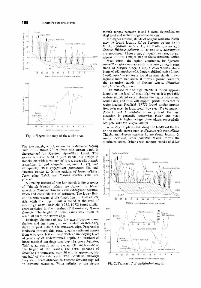
Transect studies of the undisturbed marsh showed a definite zonation in plant distribution (Figs. 1 and 2).
197
198 Short Paoers and N o t e s
200"
�9 I00
18 16 14, 12 tO 8 6 4 2 O Meters from stream at mean low water
Spartina alterniflora
Scirpus robus/us ~
ang TsYt Pho~ i . . . . """" '"~', /
18 ]6 14 12 IO 8 6 4 2 8 Meter increments from slream edge
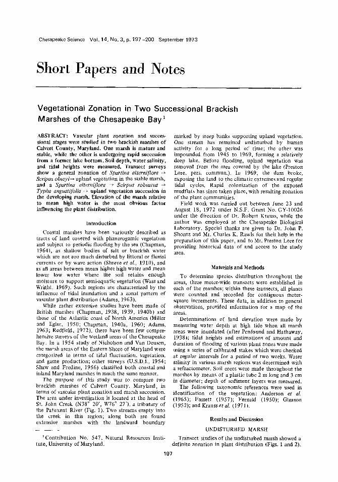
Fig. 1. Vegetation map of the study area.
mouth ranges between 0 and 5 o/oo, depending on tidal level and meteorological conditions.
On higher ground, stands of Scirpus robustus Pursh. may be found locally. Often Spartina patens (Art.) Muhl., Lythrum lineare L., Distichlis spicata (L.) Greene, Hibiscus palustris L., as well as S. alterniflora are associated. These areas, although not rare, do not appear to form a major step in the successional series.
Most often, the region dominated by Spartina alterniflora gives way abruptly to a pure or nearly pure stand of Scirpus olneyi Gray, a characteristic dom- inant of old marshes with dense stabilized sods (Bolen, 1964). Spartina patens is found in pure stands in two regions; more frequently it forms a ground cover for the extensive stands of Scirpus olneyi. Distichlis spicata is locally present.
The surface of the high marsh is found approx- imately at the level o f mean high water; it is probably seldom inundated except during the highest storm and wind tides, and thus will support plants intolerant of water-logging. Redfield (1972) found similar inunda- tion tolerance. In local areas, however, Typha angust- ifolia L. and T. latifolia L. are present; the land elevation is generally somewhat lower and tidal inundation is higher where these plants successfully compete with the Scirpus olneyi.
A variety of plants live along the landward border of the marsh. Herbs such as Hydrocotyle verticillatus Thunb. and Acorus calamus L. are found locally. In sunny locations, Rosa palustris Marsh. forms the dominant cover. Other areas support stands of Rhus
The low marsh, which occurs for a distance varying from 3 to about 20 m from the stream bank, is / characterized by Spartina alterniflora Loisel. This 2.n J species is never found in pure stands, but always in association with a variety of forbs, especially Acnida cannabina L. and Gerardia purpurea L. (?), and infrequently with Polygonum punctatum Ell. and Atriplex patula L. In the regions of lower salinity, Carex alata T.&G. and Scirpus validus Vahl. are = present.
A striking feature of the low marsh is the presence o~ of " thatch islands" which are formed by lateral • growth of Spartina rhizomes and subsequent accumu- :_o lation and consolidation of sediment. The lower limit -~ of this zone occurs at the thatch line, or level of low tide, while the upper limit is found at the level of mean high water. Redfield (1965, 1972) found similar characteristics in the marshes of Barnstable, Massa- 40o~ chusetts. The height of these islands was found to reach 30 cm at the stream edge.
Drainage channels of the low marsh become more ago- shallow and less numerous, and contain an increasing .~ depth of peat toward the landward edge. Progressing landward through this zone, organic sediment ranges X2og. from 6 to over 100 cm deep with an underlying layer E of gray clay of undetermined depth. An interface of ~, black muck 6 cm deep separates the two substrates. Tidal range was found to average 60 cm; because of the height o f the islands, the aerial portions of Spartina are inundated only 30 cm, or approximately one-half of the tidal cycle. The rootstalks, although they were never observed to become dry, are exposed to climatic extremes. Water salinity at the stream
Typho angustifolia
100
30 27 24 21 18 15 12 9 6 3 0
Meters from stream at mean low water
/'/ c~ Spartlno patens 180 / " 1-60 % cover Scirpus [ I :~ %"*'% L4,0 (lO%=600stem~) a,~,~ !x / +'.. +.. ! -~o , l
\ ~ / ..... , '": : " ~ o ~. / / / 21 18 15 |2 9 / \ j
/ i [ \ / / Spartina alternifiora I V / t
l, , \ / . '~J~] Acorus . . . . . . . . \~/~Scirpus robustus /~. Si ;
gus~folia ~-'Cl' . .-'", /'~-J �9 Acnida cannabina
0 30 27 24 21 18 15 12 9 6 3 Meter increments from stream edge
Fig. 2. Transect C of undisturbed marsh.

radicans L. with Myrica cerifera L, Baccharis halmi- folia L., and Rosa palustris. Progressing to higher elevations, plants of the oak-pine association are found: Pinus taeda L.,P. virginiana Mill., Quercus alba L., Q. velutina Lain., Q. prinus L., Fagu~ grandifolia Ehrh., Liquidambar styraciflua L., Liriodendron tulip- ifera L., llex opaea Ait., Cornus florida L., Sassafras albidum (Nutt.) Noes, and Kalmia latifolia L.
DEVELOPING MARSH
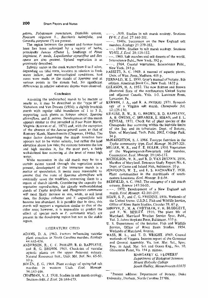
The transect surveys of the developing marsh showed a more uniform zonation than that of the older area (Figs. t and 3). Extensive mudflats, fully exposed only at the lowest tides, support scattered plants of Spartina alterniflora and Eleocharis parvuta (R.&S.) Link. Throughout the region are remnants of old thatch islands that were formed by S. alterniflora prior to the building of the dam.
At the level of mean low water, more robust stands of Spartina alterniflora survive. At this level, it is commonly in association with Eleocharis parvula and Valisneria americana Michx.; on the higher ground where thatch island formation is beginning, it is found in pure stands. Flooding of the aerial parts occurs during about one-half of the tidal cycle at the higher elevations of this zone, while the lower regions receive correspondingly more inundation. At no time does the soil surface of the area become dry.
Short Papers and Notes 1 g9
Progressing farther upland, a relatively narrow belt in which Scirpus robustus appears as the dominant species may be found. Spartina alterniflora is com- monly present in large numbers. This region is of slightly higher elevation than the one described above; height and duration of tidal inundation are therefore less.
The final zone in this marsh succession supports an extensive and virtually pure stand of Typha angusti- folia. One stand of T. latifolia with Scirpus olneyi and several ofPhragmites communis Trin. are found within this region. It has been suggested (McNaughton, 1966) that T. angustifolia, by earlier and greater seed production, holds a competitive advantage over T. latifolia in new colonization, while greater rhizome proliferation in the latter makes it a good competitor once established. Phragmites has a similar ability to invade other communities through rhizome prolifera- tion. It was also observed that plants blown to the ground by tropical storm Agnes in June, 1972 had, within a few weeks, developed sprouts at each node of the parent stalk. Low fresh areas near the landward border support Eleocharis palustris (L.) R.&S. and "Sagittaria latifolia Willd. For the most part, this region is totally inundated for only a few minutes during each tidal cycle; plants surviving here must withstand periodic drying of the soil surface. In the driest parts of the Typha zone, isolated individuals of Spartina
Developing l i ~ 1 1 ' 1 1 ,. Marsh
;~. - . ~. : : . - " . ~ : ,
mudflats (pioneer Spartina) Spartina aherniflora Scirpus robust us Scirpus olneyi Spartina patens Typha spp.
Phragmites communis
Rosa palustris
colonizers of former forest area
upland vegetation
X transect line
9 :~s p,o , meters
Undisturbed Marsh
St. John Creek 41 ~
Fig. 3. Transect F of developing marsh.
§
\
200 Short Papers and Notes
patens, Polygonum punctatum, Distichlis spicata, Panicum virgatum L., Baccharis halmifolia, and Gerardia purpurea (?) are present.
The region between the present and former forest lines has been colonized by a variety of herbs, principally Juncus effusus L. Seedlings of Pinus virginiana, P. taeda, Liquidambar styraciflua and Ilex opaca are also present. Upland vegetation is as previously described.
Salinity varies in the creek waters from 0 to 5 0/o% depending on tidal state, location in relation to fresh water inflow, and meteorological conditions. Soil cores were made in the stands of Spartina and at various points in the stream bed. No significant differences in relative substrate depths were observed.
Conclusion
Assuming the undisturbed marsh to be mature or nearly SO, it may be described as the "type lI" of Nicholson and Van Deusen (1954): a slightly brackish marsh with regular tidal inundation of 1 to 3 ft, supporting such plants as Scirpus olneyi, Spartina alterniflora, and S. patens. Development of this marsh appears similar to that recorded in Four Point Marsh, Virginia (Kerwin etaL, 1971) and, with the exception of the absence of the Juncus gerardi zone, to that of Romney Marsh, Massachusetts (Chapman, 1940a). The major factor determining the marsh zonation here appears not to be water salinity, but rather the land elevation above low tide; the ecotone between the low and high marshes is, for the most part, a fairly well-defined line occurring at the level of mean high water.
While succession in the old marsh may be to a certain extent traced through the vegetation zones present, development of the immature marsh is a matter of speculation. It seems most reasonable to assume that the zone of Spartina alterniflora will eventually cover the mudflats, converting them to a region of thatch islands. Considering the capacity for vegetative reproduction, the already well-establislred stands of Typha latifolia and Phragmites communis will most likely increase in size, while, as soil level rises, t he Scirpus robustus and T. angustifolia will become less abundant. It is possible that in time, this marsh will support a vegetation similar to that of the older area; however, it is impossible to predict the effect Of species such as P. communi~ which are present in the developing region but not in the stable region.
LITERATURE CITED
ADAMS, D. A. 1963. Factors influencing vascular plant zonation in North Carolina marshes. Ecology 44:445-456.
ANDERSON, R., C. C. PHILIPP, R. D. RAPPLEYE, and R. G. BROWN. 1965. Check-list of vascular aquatic plants on the upper Patuxent estuary. Natural Resources Inst., Univ. Md. Ref. No. 65-50. 10p.
BOLEN, E. G. 1964. Plant ecology of spring-fed salt marshes in western Utah. Ecol . Monogr. 34:143-166.
CHAPMAN, V. J. 1938. Studies in salt marsh ecology. Sections I-III. J. Ecol. 26:144-179.
- - - . 1939. Studies in salt marsh ecology. Sections [V-V. s Ecol. 27:160-201.
- - - . 1940a. Succession on the New England salt marshes. Ecology 21:279-282.
- - - . 1940b. Studies in salt marsh ecology. Sections VI-VII. s Ecol. 28:118-152.
- - - . 1960. Salt marshes and salt deserts of the world. lnterscience Publ., New York. 392 p�9
�9 1964. Coastal vegetation. Interscience Publ., New York. 245 p.
FASSETT, N. C. 1969. A manual of aquatic plants. Univ. of Wisc. Press, Madison. 405 p.
FERNALD, M. L. 1950. Gray's manual of botany. 8th edition. American Book Co., New York. 1632 p.
GLEASON, H. A. 1952. The new Britton and Brown illustrated flora of the northeastern United States and adjacent Canada. Vols. 1-3. Lancaster Press, Lancaster, Pa.
KERWIN, J. A., and R. A. PEDIGO. 1971. Synecol- ogy of a Virginia salt marsh. Chesapeake Sci. 12:125-130.
KRAUSS, R. W., R. G. BROWN, R. D. RAPPLEYE, A. B. OWENS, C. SHEARER, E. HSlAO, and J. L. REVEAL. 1971. Check list of plant species of the Chesapeake Bay occurring within the hightide limits of the Bay and its tributaries. Dept. of Botany, Univ. of Maryland, Tech. Publ. 2002, College Park. 34 p.
McNAUGHTON, S. J. 1966. Ecotype function in the Typha community type. Ecol. Monogr. 36:297-325.
MILLER, W. R., and F. E. EGLER. 1950. Vegetation of the Wequetequock-Pawcatuck tidal marshes, Connecticut. Ecol. Monogr. 20:145-172.
N1CHOLSON, W. R., and R. D. VAN DEUSEN. 1954. Marshes of Maryland. Resource Study Report No. 6. Dept. of Game and Inland Fish, Baltimore. 10 p.
PENFOUND, W. T., and E. S. HATHAWAY. 1938. Plant communities in the marshlands of south- eastern Louisiana. Ecol. Monogr. 8:1-56.
REDFIELD, A. C. 1965. The ontogeny of a salt marsh estuary. Science 147:50-55.
- - - . 1972. Development of a New England salt marsh. EcoL Monogr. 42:201-237.
SHAW, S. P., and C. G. FREDINE. 1956. Wetlands of the United States. U.S.D.I. Fish and Wildlife Service, Office of River Basin Studies. Circular 39.67 p.
SHREVE, F., M. A. CHRYSLER, F. H. BLODGETT, and F. W. BESLE~. 1910. The plant life of Maryland. Maryland Weather Service Spec. Publ., Vol. 3. Johns Hopkins Press, Baltimore. 533 p.
U. S. Department of the Interior. Fish and Wildlife Service, Office of River Basin Studies. 1954. Wetlands of Maryland. Boston.
WASS, M. L., and T. D. WRIGHT. 1969. Coastal wetlands of Virginia. Interim report of the Governor and General Assembly. Va. Inst. Mar. Set., Spec. Rep. in Appl. Mar. Sci. and Ocean Eng., No. 10. Gloucester Point, Va. 154 p. mimeo.
MARGARET G. FLOWERS 2 Departm en t of Biological Sciences Mount Holyoke College South Hadley, Massachusetts 01075
2Present address: Department of Botany, Duke University, Durham, North Carolina 27706.