value-adding for impacts and adaptation evans ipcc...group ii report due april 2014 . ......
TRANSCRIPT

© Yann Arthus-Bertrand / Altitude
Regionalizing global models:
value-adding for impacts and adaptation
Jason Evans University of New South Wales
Regionalizing Global models
• Why would we want to regionalize (or downscale) global climate
projections?
• How can we downscale climate projections?
• What do global models predict for Australia or Sydney?
• What downscaled climate projection data is available?
• What downscaled climate projection is coming soon?

Why would we want to regionalize
(or downscale) global climate
projections?

Global model simulations

Global model simulations

Global to Regional Precipitation
Global Model Regional Model

Global model simulations
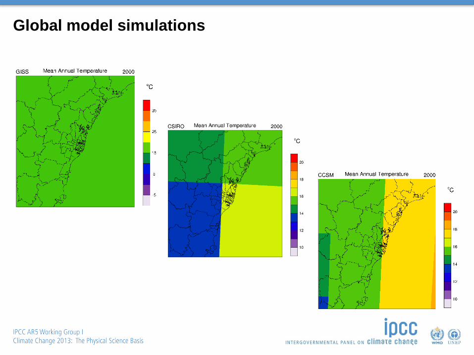
Global model simulations

Global to Regional Temperature
Global Model Regional Model

For Impacts and Adaptations
• Often local or regional in nature
• Often sensitive to extremes (which are regional/local in nature)
• Management decisions often made locally
So – Information provided should be locally relevant and preferably
application ready
Impacts and adaptation will be directly addressed in the IPCC Working
Group II report due April 2014

How can we downscale climate
projections?

Methods for providing regional climate projections
Scaling
• Alter past observations based on changes in global models
• Assumes the future looks like some multiple of the past
• Needs long time series of observations
• Easy to calculate
Statistical Downscaling
• Find a statistical relationship between climate produced by a global model and
station data. Use this relationship to downscale the global model projection
• Assumes that this statistical relationship does not change in the future
• Needs long time series of observations
• Does not require a lot of computing power
Dynamical Downscaling
• Apply mathematical model of climate system at higher resolution
• Assumes that the physical laws of nature do not change in the future
• Solves for all climate variables
• Requires a lot of computing power

What do global models predict for
Australia or NSW?

Mean temperature change by end of 21st century
RCP4.5
RCP8.5
CMIP5 models
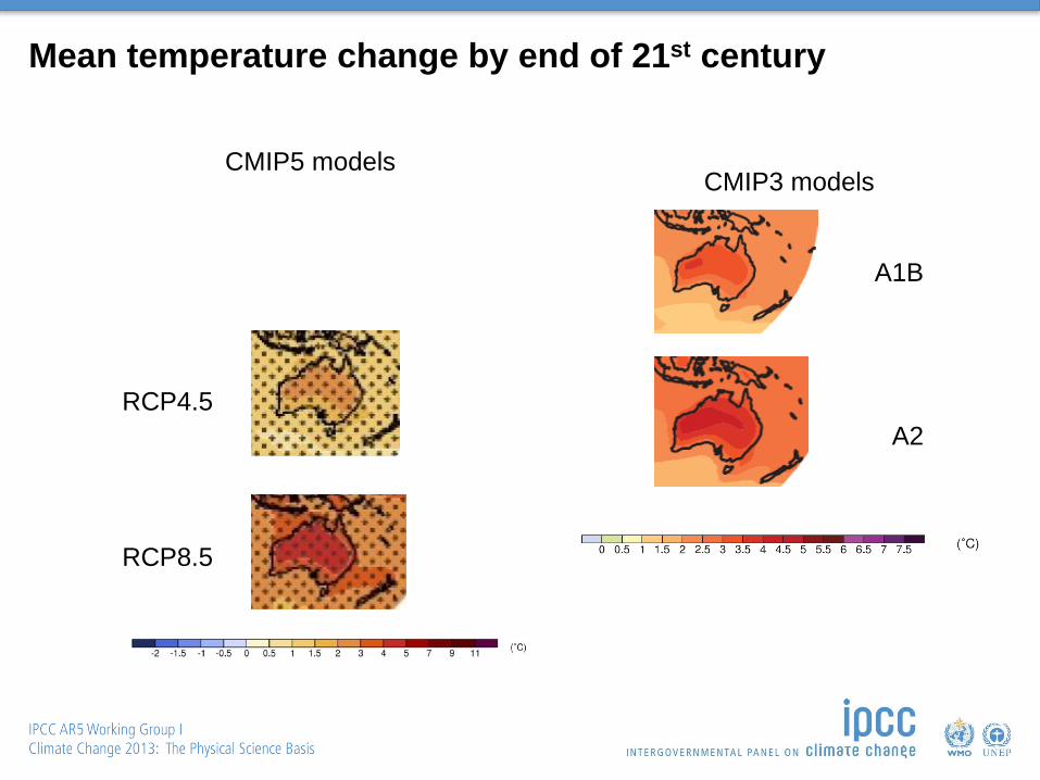
Mean temperature change by end of 21st century
RCP4.5
RCP8.5
CMIP5 models CMIP3 models
A1B
A2
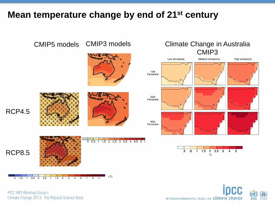
Mean temperature change by end of 21st century
RCP4.5
RCP8.5
CMIP5 models CMIP3 models
A1B
A2
Climate Change in Australia
CMIP3

Mean precipitation Change at end of 21st century
DJF
MAM
JJA
SON
CMIP5 Models
RCP8.5

Mean precipitation Change at end of 21st century
DJF
MAM
JJA
SON
CMIP5 Models
RCP8.5 CMIP3 Models
A1B

Mean precipitation Change at end of 21st century
DJF
MAM
JJA
SON
CMIP5 Models
RCP8.5 CMIP3 Models
A1B
Climate Change in Australia
CMIP3 (High emission)
DJF
MAM
JJA
SON

What regional (downscaled)
climate projections are already
available for NSW?

Some available regional climate data
Scaling approaches
• High resolution climate projections produced Australia-wide using a scaling
approach based on CMIP3 models, by former QCCCE for DAFF. Available here
http://www.longpaddock.qld.gov.au/climateprojections/about.html
• High resolution climate projections produced in SEACI using a scaling approach for
south-east Australia based on CMIP3 models.
http://www.seaci.org/research/futureProjections.html
Statistical Downscaling
• Many people have produced their own statistical model for downscaling to their
stations of choice.
• One analogue statistical technique developed at BoM has been applied Australia-
wide (Bertrand Timbals group). Availability?
Dynamical Downscaling
• Climate Futures for Tasmania. CSIRO downscaled with the CCAM model. Available
here https://dl.tpac.org.au/tpacportal/#category=17

What regional (downscaled)
climate projections are being
prepared for NSW?

NARCliM NSW/ACT Regional Climate Modelling project http://www.ccrc.unsw.edu.au/NARCliM/
• NARCliM is being developed by the NSW Office of Environment and Heritage, in
collaboration with the Climate Change Research Centre at the University of NSW.
• NARCliM is delivering regional climate projections at 10km resolution across NSW
& ACT by the end of 2014 (50km resolution over Australia)
• 4 CMIP3 GCMs are being downscaled by 3 RCMs to produce a 12 member
ensemble
• Three 20 year periods are being simulated: 1990-2010, 2020-2040, 2060-2080
• Uses the SRES A2 emission scenario
• The data will be made available through a web portal

CORDEX COordinated Regional climate Downscaling EXperiment
• A World Climate Research Programme (WCRP) effort focused on regional
climate modelling and downscaling (RCD
• A regional climate companion to the CMIP5 GCM experiments.
• Develop a framework to evaluate and possibly improve RCD techniques for
use in downscaling global climate projections.
• Foster an international coordinated effort to produce improved multi-model
RCD-based high resolution climate change information over regions
worldwide for input to impact/adaptation work and to the IPCC 5th
Assessment Report (AR5).
• Promote greater interaction and communication between global climate
modellers, the downscaling community and end-users to better support
impact/adaptation activities.
• Standard resolution 50km
• Data will start to become available in 2014 and increase over next several
years

CORDEX Domains

CORDEX – AustralAsia Domain

© Yann Arthus-Bertrand / Altitude
www.climatechange2013.org Further Information