v-8 - hants
TRANSCRIPT

1
V-8
Guidance on the application process and on completing this application form is available at from the Solent LTB website. One application should be completed per project. Applications are restricted to a maximum of 20 pages (excluding accompanying documentation). Please amend the sizes of the response boxes to suit your application. Accompanying Documentation Accompanying documentation should be restricted to:
Letters of support from stakeholders;
Map(s); and
Scheme drawing(s). Deadline for applications Applications must be submitted to the Solent LTB by 1800 on Wednesday 12
th June 2013. Please submit electronic
versions of this form along with any accompanying documentation to: [email protected]. Where email attachments sum to 10mb or above in file size, you should ensure that arrangements are made for these to be received by the LTB by the above deadline. Please note, your Project Application Forms will be published on the Solent LTB website.
Section A: Applicant Information
A1 Lead applicant name (Organisation)
Portsmouth City Council.
A2 Joint applicant name(s) if applicable
Not applicable.
A3 Lead applicant address
Civic Offices, Guildhall Square, Portsmouth, PO1 2BG.
A4 Bid manager details Name: Simon Moon
Position: Head of Transport & Environment
Employer: Portsmouth City Council
Telephone: 023 9283 4092
Email: [email protected]
Section B: Eligibility Check List
B1 Is the project included within the Transport Delivery Plan (TDP)?
Yes No
B2 Is the project expected to have a clearly defined scope?
Yes No
B3 Is the project expected to drive employment and/or housing growth and/or solve a current or future transport problem that constrain economic and/or housing growth or that safeguards existing employment?
Yes No
B4 Is the project expected to provide sustainable access?
Yes No
B5 Is the project expected to comprise a 100% capital funding request from the LTB?
Yes No

2
B6 Is the project supported by a local contribution (public and/ or private and revenue and/ or capital) of at least 25% of the overall project cost?
Yes No
B7 Will the project comprise a capital funding request from the LTB of over £2,000,000?
Yes No
B8 Is the project expected to deliver high value for money? Yes No
B9 Would the project be largely delivered between 2015-19? Yes No
B10 Is the project supported by the Local Transport Authority/ies whose area(s) within which the proposal would be delivered?
Yes No
B11 For a project that is on the strategic highway or rail networks is an in principle letter of support attached?
Yes N/A No
Section C: Project Summary
C1 Project title
The Hard Interchange Scheme
C2 Headline project description.
The scheme involves replacing the existing bus interchange and improving the public realm to provide a safe, attractive and efficient environment for public transport users, pedestrians, and cyclists. Evidence from developers and the business community indicate that a high quality environment is needed to unlock development at eight identified opportunity sites (delivering at least 300 residential units, 25,000m
2 of hotel
space, and 20,000 m2 of office floorspace, together with lower levels of retail floorspace). In the short-term it
will help unlock development at the Brunel House site, generating 186 direct and 82 indirect net jobs within the region; and £5.554 million GVA. Development at the other sites in the vicinity of The Hard could generate an additional £57.115 million GVA in the longer term.
C3 Is this a request for a grant or a loan? Grant Loan
C4 Project costs.
Total Project Cost £6.832 million. Since the submission of the original proforma in June, we have secured additional budget to cover design work, consultation and engagement, preparation and submission of planning application, producing a business case, etc. These activities were not fully captured in the original proforma, and have increased the Council’s local contribution to the scheme.
LTB Funding Request £4.832 million.
Local Contributions (Please specify source and whether they are confirmed)
£2.000 million.
Source: Corporate reserves (see F4).
C5a Do alternative funding options exist to cover the full project cost?
Yes No
C5b If ‘Yes’ to C5a, please explain why LTB funding is being sought.
N/A
C5c If ‘No’ to C5a, please list other funding sources considered and reasons for rejection.
The scheme is not included within the Wave 2 Solent City Deal Expression of Interest which was submitted in January 2013, and no other funding sources have been identified. See response to D7 for further information.
C6 Describe the geographical area covered by the project
The Hard lies between the popular attractions of the Portsmouth Historic Dockyard and Gunwharf Quays, and is located about a mile south-west from the city centre (Figure A1). It offers bus and coach transport, and the neighbouring Portsmouth Harbour Station provides trains to London, Cardiff and Brighton. There are also two passenger ferry services running from The Hard Interchange: a fast catamaran service operated by Wightlink travels to Ryde on the Isle of Wight every 30 minutes, and the Gosport Ferry runs at least every 15 minutes to

3
Gosport. The area currently functions as a key city gateway and public transport interchange but is also an area of historic and visual interest enjoyed by many residents and visitors every year.
C7 Has any Equality Analysis been undertaken in line with the Equality Duty?
Yes No
A preliminary Equalities Impact Assessment (EIA) was undertaken as part of the preparation of the SPD. It was concluded that a full assessment was not needed because the SPD would not hinder or help equality opportunity in relation to race, gender, sexual orientation, religion/belief, relationships between groups or socially excluded groups.
C8 Please indicate if any information contained in this application is of a commercial nature and should not be published. (State which questions)
Financial information in Section F.
C9 Provide a list of the Partnership Bodies (if any) you plan to work with in the design, delivery and operation of the scheme.
SHBOA (South Hampshire Bus Operators Association), South West Trains, Network Rail, Gosport Ferry, Wightlink, National Express, Portsmouth Cycle Forum, Taxis operators, Brunel House developer (Bouygues Development ), Gunwharf Quays, the Historic Dockyard, Gosport Borough Council, and the Isle of Wight Council. Letters of support are included in Appendix B.
C10 Earliest start date April 2015 for construction.
Desired start date April 2015 for construction.
Delivery timescale (months) 12 months (see G6).
C11 Are any associated consents in place? If not, state when these are expected to be in place.
No, a planning application for the new interchange is expected to be in place by September 2014.
C12 Is this scheme linked to any other applications to the LTB? If so, please provide the project title(s).
Complements other scheme applications to improve access to Central Portsmouth by sustainable modes and create a transport network which will support development within Portsmouth’s Western Corridor: 9. South East Hampshire Bus Rapid Transit (The Hard Interchange represents a key terminus destination); 2. Portsmouth City Centre Transport Scheme.
C13 If you are the Lead Authority for more than one application, please prioritise your projects.
Applications were prioritised as follows (June 2013):
1 = City Centre Transport Scheme;
2 = The Hard Interchange;
3 = Portsmouth BRT and Highway Network Improvements Package;
4 = Dunsbury Hill Farm Link Road; Horsea Island Bridge Link.
The order of priority was agreed by the Members at an Informal Cabinet Meeting on 10th
June 2013. However, in light of the funding available, delivery timescales and new developer interest, our priority is now The Hard Interchange and Dunsbury Hill Farm Link Road.
Section D: The Strategic Case
D1 Provide a description of the transport project.
The scheme is based on proposals set out in The Hard Supplementary Planning Document (SPD) (Adopted 2010, Updated 2012), which involves replacing the existing bus interchange at The Hard, and improving the public realm, wayfinding and cycle parking facilities. It involves:
a contemporary bus interchange facility that is clearly legible within the townscape, incorporating a high quality interchange building, seating areas and passenger information;
a clear and accessible layout that works well for both bus and vehicle manoeuvring and for pedestrian and cycle accessibility (see Figure A2);

4
clear access into the bus interchange for taxis and delivery vehicles (accessing the railway station) and a taxi waiting area that is safe for pedestrians to use;
wider pedestrian footways from the railway station and ferry terminals to The Hard and to Gunwharf Quays;
the continuation of the existing cycle paths around the area, especially those originating from the city centre to Gunwharf Quays;
the provision of secure, safe cycle parking and storage facilities, a significant proportion of which should be covered in order to offer protection from wind and rain in this exposed location (currently being delivered as part of the PCC LSTF project); and
public realm improvements elsewhere within The Hard SPD area (e.g. creation of one way traffic flow outside Victory Gate (see Figure A5) to enable narrowing of the road and creation of a safer pedestrian and cycling environment.
The new bus interchange will provide capacity for at least eight bus/coach stops which the Council views as sufficient to meet existing and future capacity, but we will work with bus operators during the design phase to agree the final layout. Additional coach and vehicle drop off points could also be introduced on The Hard and at the southern end of Queen Street, adjacent to the Dockyard Wall (Figure A5).
The project will deliver the following outcomes:
A new interchange which provides a safe, attractive and efficient environment for public transport users, pedestrians, and cyclists.
An improved experience for pedestrians and cyclists moving between the railway station, Gosport ferry, The Hard and Gunwharf Quays.
Improved travel information of all modes.
Greater use of public transport as a means of accessing this area of Portsmouth.
Contribute to the creation of an attractive gateway to the city which will help shape The Hard into a vibrant waterfront destination, building on its function as a key city gateway and its reputation as an area of historic character and charm (based on the vision set out in The Hard, SPD).
The existing transport interchange is owned by Portsmouth City Council.
D2 Explain how the project will respond to current and/or future transport problems that constrain economic and/or housing growth or that will safeguard existing employment areas.
The two visitor attractions bounding the SPD area – Gunwharf Quays and the Historic Dockyard – respectively attract over 6 million and 400,000 visitors each year. 40% of visitors to Gunwharf and 15% of visitors to the Historic Dockyard arrive by public transport.
On weekdays around 40 buses per hour pass through the interchange and there are over 20 coach departures per day. Each month, over 133,000 passengers use the railway station, around 300,000 use the Gosport ferry service and approximately 115,000 passengers travel on the Wightlink Fastcat connection to the Isle of Wight.
All of these factors combine to create an extremely busy pedestrian environment. There is considerable rail-bus-ferry interchange, however very little information is available to passengers arriving by rail about the location and frequency of bus services. A large number of commuters, particularly those arriving by ferry, use cycles to continue their journey.
In enhancing the area as a gateway to the city, improving the way in which the area functions as a transport interchange is critical. The existing bus interchange and edge of the railway station is considerably dated and appears ‘tired’ and unwelcoming. It covers a large decked area in front of the railway station and is extremely inefficient in terms of its layout. It is poorly designed in terms of passenger accessibility. The configuration of space is muddled with pedestrians funnelled along narrow pavements or forced to cross over bus lanes in order to access waiting stands. This acts as a barrier to pedestrians and cyclists exiting the railway station and ferry terminals, ‘funnelling’ them onto two narrow pathways that head towards the northern and southern ends of the Hard. There is little high quality street seating and the area does not present a welcoming environment for visitors or residents. There is also a need to remove the unsightly ‘barrier’ that currently borders the interchange platform and replace it with a new quality edge treatment.
A PERS Audit was undertaken in May 2013 to clarify the nature of the problems from a pedestrian perspective. PERS or ‘Pedestrian Environment Review System’ is a walking audit tool developed by TRL to assess the level of service and quality provided for pedestrians across a range of pedestrian environments. Specific issues identified for The Hard are as follows:
Lack of tactile paving or legibility information for sensory impaired people.

5
Poor location of crossings given the high volume of bus and taxi movements.
The pavement width on Station Approach South is only 1.9 metres, and is not suitable for the high number of pedestrians which use it (see photo). In places the dropped kerb extends the full width of footway causing an obstruction. Taxi loading also obstructs the footway.
On Station Approach North, signs warning pedestrians about theft heightens fear of crime, and shelters obstruct movements.
Lack of crossing facilities on The Hard road limits permeability, and there is business waste and rubbish on the street.
The interchange area has no CCTV advertised and there is a lack of natural surveillance. There is no soft landscaping.
There is an information area, but no local area map, between mode information, or real time information.
The SPD therefore proposes:
allocating an area for a new bus interchange that will retain the required number of bus stops ;
‘joining-up’ the new bus interchange with high quality public realm improvements to create a comfortable environment for pedestrians;
ensuring legible and accessible routes between public transport, the Historic Dockyard and Gunwharf Quays;
establishing clear linkages between public transport and other parts of the city; and
introducing secure cycle parking facilities at the interchange and within development sites.
Creating a new bus interchange, which is more efficient in its use of space than the existing facility, will enable public spaces and routes to and from the railway station and ferry terminals to be improved (e.g. new street trees could be introduced on The Hard to complete the existing line running from Ordnance Row to the Dockyard (Victory) Gate).
Summary of problems:
Top left: interchange building
Top: Pedestrian routes bisect bus routes.
Top right: Narrow pavement on Station Approach South unsuitable for the volume of pedestrians.
Bottom left: Brunel House
Bottom right: Poor pedestrian crossing environment
Critical infrastructure role
The scheme is identified as ‘critical infrastructure’, needed to support Portsmouth’s growth and development over the period of the Core Strategy (up to 2026) (Portsmouth Plan, Appendix 2). It has a critical role to play in unlocking development at a number of opportunity sites identified within the SPD (see Figure A3 – refer to elsewhere) which have the potential to deliver approximately 300 residential units, 25,000m2 of hotel space, 20,000 m2 of office floorspace together with lower levels of retail floorspace. It also forms a central part of the SPD vision for the area:
“To shape The Hard into a vibrant waterfront destination, building on its function as a key city gateway and its reputation as an area of historic character and charm. New passenger facilities, cultural opportunities and places to live, to work, to stay, to eat and to relax will enhance the experience of visitors and residents alike. The creation of a distinctive public realm will revitalise and transform the area.”

6
Development potential
The importance of a new interchange in unlocking development potential in this area is demonstrated in the letters of support included in Appendix B, e.g.:
“The bus interchange improvements are a high priority and should be targeted as one of the first developments on this site.” (Chamber of Commerce)
“The viability and success of such a project is intrinsically linked to the wider gentrification of this area. In the current climate attracting investment for schemes like Brunel House is challenging; the investment market will see the creation of a modern interchange as a very powerful and positive signal of the Council’s long term investment and support in the area and thus more willing to help support and unlock the scheme. (Bouygues Development, Brunel House developer)
My clients have the investment monies to hand to use on these properties and land but are holding back as they do not feel conformable with the condition of the street. (Agent for potential developer of a boutique hotel)
A planning application relating to the development of the existing Brunel House site (Site 3 – The Hard South in the SPD) is expected imminently. This will create a tall, landmark building on corner of The Hard and College Street (35+ storeys) that positively contributes to the skyline of the city; in a prominent location at the southern end of The Hard, opposite the pedestrian entrance to the successful Gunwharf Quays development.
D3 Explain how the project will contribute to the Solent LEPs economic growth agenda.
This scheme is consistent with PUSH Spatial Strategy Policy 1 (Overall Development Strategy) which identifies Portsmouth and Southampton as the dual focuses for investment and development, in accordance with the PUSH Cities First principle. Its intended outcomes are also consistent with PUSH Spatial Strategy Policy 2 (Urban Regeneration) which states that “The environmental quality of the two cities and other urban areas should be enhanced so that they are increasingly locations where people wish to live, work and spend their leisure time.”
It supports the LEP priority to drive regeneration of the urban areas (Strategy for Growth, p20), by creating an environment which will help unlock eight opportunity sites within the locality (see Figure A3), with the potential to deliver at least 300 residential units, 25,000m
2 of hotel space, and 20,000 m
2 of office floorspace.
A planning application is expected imminently for the redevelopment of the Brunel House site (Site 3 – The Hard South) to accommodate 650 student beds, 220 flats, a 200 bed hotel and ground floor retail units. This could generate 186 net direct jobs, and a further 82 indirect jobs; and £5.554 million GVA. Development at other sites within The Hard area could generate 979 net direct jobs, and a further 431 indirect jobs; and £57.155 million GVA. A further 76 direct and indirect construction jobs will also be generated through construction of the new interchange; with further construction jobs generated by the planned developments.
D4 Explain how the project fits with Local Transport Authority objectives and Local Plans.
Fit with local transport objectives is summarised below:
LTP3 Objective Impact Evidence
Reduced dependence on the private car through an increased number of people choosing public transport and the ‘active travel’ modes of walking and cycling
See D5.
Improved awareness of the different travel options available to people for their journeys, enabling informed choices about whether people travel, and how
See D5.
Improved journey time reliability for all modes - See E5
Improved road safety within the sub-region See E6
Improved accessibility within and beyond the sub-region See D5.
Promoting a higher quality of life See E12
Fit with Local Plan:
The Hard area is now within the city centre boundary identified by policy PCS4 – Portsmouth City Centre of the Portsmouth Plan, and is referred to in policy PCS17 – Transport, which safeguards land for a new interchange facility at The Hard.
The scheme also contributes to:
Objective 2 of the Portsmouth Plan: To make Portsmouth an accessible city with sustainable and integrated transport – Improve the city’s transport hubs and interchanges such as a new train/bus interchange at Portsmouth & Southsea railway station and physical improvements to the Hard interchange at Portsmouth Harbour.

7
Objective 3 of the Portsmouth Plan: To develop Portsmouth as a city of innovation and enterprise, with a strong economy and employment opportunities for all – Improving the visitor experience especially around the Hard where better links will be made between the visitor destinations of the Historic Dockyard, Gunwharf Quays and the seafront.
PCS4 is supplemented by The Hard Supplementary Planning Document (Adopted 2010, Updated 2012), which sets out the vision for the area (see C2), and the proposals for the interchange set within the following priorities: strengthening the role of the area as a key gateway and transport interchange; improving public areas; accommodating a viable mix of uses, and ensuring quality, distinctiveness and sensitivity of design.
The scheme is identified as ‘critical infrastructure’, needed to support Portsmouth’s growth and development over the period of the Core Strategy (up to 2026) (Appendix 2 of Portsmouth Plan).
D5 Does the project improve sustainable access? If so, is this to a town, city centre or major employment area?
Yes, see outcomes identified in D1. It will primarily improve access to / from Portsmouth City Centre.
The scheme will create a more attractive environment for passengers (particularly during evenings), and encourage sustainable access to a wider range of destinations:
Portsmouth City Centre (easily accessible by bus, cycle or foot);
Southsea Centre (easily accessible by bus, cycle or foot e.g. via Millennium seafront walk and recently completed seafront cycle way);
other urban centres within the Solent sub-region (via Gosport Ferry and Wightlink fast catamaran service to Ryde on the Isle of Wight; rail services to Havant, Fareham, Southampton and intermediate locations; and sub-regional bus services);
key destinations beyond the sub-region (Portsmouth Harbour Station provides trains to London, Cardiff and Brighton); and
retail and leisure attractions within the locality (including Gunwharf Quays and the Historic Dockyard), from all of the above locations.
The interchange improvements will complement initiatives being delivered through the Portsmouth Local Sustainable Transport Fund programme, which focuses on improving connectivity between the City Centre, the Harbour Area and Southsea by sustainable modes (see below). Behaviour change initiatives being delivered through the PCC and TfSH Local Sustainable Transport Fund packages will help ensure individuals respond to the opportunities available, and change their travel habits.
D6 Does this project form part of a wider programme of investment? If so, what is the wider programme and how critical is LTB investment for this project to the successful delivery of the overall programme?
Yes, part of a wider programme of investment (see Figure A7) to:
Improve access to Central Portsmouth by public transport and cycle: includes Tipner P&R Service (opens April 2014); TfSH LSTF programme of corridor improvements, smartcard ticketing and behaviour change (2012/13-2014/15); SE Hants BRT Future Phases Study (April 2012) and Design Feasibility and Business Case Study (Sep 2013); essential maintenance work to Northern Road Bridge on the A397, a key artery into the City Centre and an integral part of the public transport ‘Zip’ corridor; Western Corridor Cycle and pedestrian improvements linking the Queen Alexandra Hospital, Paulsgrove, Tipner and the City Centre (Cycle City Ambition Grant submitted end Apr 2013); City Centre Transport Scheme (separate Major Scheme EoI); and Tipner-Horsea Island Public Transport Bridge Link providing a congestion-free bus route between Fareham direction and the City Centre (EoI for Local Infrastructure Funding submitted April 2013);
Improve connectivity within Central Portsmouth (City Centre, Harbour Area, Southsea): Being implemented through two LSTF programmes:
A Connected and Sustainable Centre (PCC) includes the following relevant measures: wayfinding to / from The Hard, The Hard cycle route, Brompton bike hire and secure cycle parking at Portsmouth Harbour Station, low cost public realm improvements on the two approaches to The Hard (Queen St and Park St), small scale public realm improvements at Portsmouth Harbour Station including a canopy between the train station and the Gosport Ferry terminal, improvements to the existing Millennium Walk along the seafront, and a Park and Sail service from the International Port to Gunwharf Quays.
A Better Connected South Hampshire (TfSH) includes funding for the following schemes in The Hard area, which are of relevance to the SPD vision: real time information along key bus corridors and at interchange (planned implementation 2014/15); smart-ticketing (planned implementation 2014/15).

8
These improvements, along with The Hard Interchange scheme will help reduce the reliance on the car for short trips within Portsmouth, and encourage visitors and shoppers to make the most of Portsmouth’s retail and tourism offering across the three centres (by encouraging them to walk or cycle between the three locations, and increasing levels of physical activity).
As described above, The Hard interchange scheme has been identified as ‘critical infrastructure’, needed to support Portsmouth’s growth and development over the period of the Core Strategy. The improvements delivered through the LSTF programme will significantly improve transport access to the area, and improve the quality of the environment, but are complementary measures and will not address the poor quality of the public realm environment. LTB investment for this project is critical to the successful delivery of the Core Strategy.
D7 What will happen if funding for this project is not secured?
If funding for the interchange is not secured, the scheme will not be delivered within the foreseeable future. With the exception of the Brunel House site (for which a planning application is imminent), development opportunities elsewhere in The Hard are at an early stage (with some developers unwilling to progress opportunities until plans for a new interchange are confirmed). It is therefore unlikely that sufficient Community Infrastucture Levy contributions could be secured in the short to medium term to deliver a new interchange. The scheme is not included within the Wave 2 Solent City Deal Expression of Interest which was submitted in January 2013, and no other funding sources have been identified.
D8 Is this a project that has funding from another LTB area or is located within another LTB area? If so, please explain the benefits to the Solent LTB area.
N/A
Section E: The Economic Case
Transport Economics
E1 Indicate the level of Benefit Cost Ratio (BCR) that this scheme would be expected to realise following WebTAG appraisal?
<1
=/>1 - <1.5
=/>1.5 - <2
=/>2 - <4
>4
Please describe the basis of the expected BCR.
Costs and Benefits (2010 prices)
Improved quality of journey £9.64 million
Visual amenity benefits £8 - £10 million
Public realm benefits (based on PERS Scores) £2.5 million
Land value benefits £1.6 million
Present Value for Benefits £18.5 million +
Broad Transport Budget £9.21 million
Present Value for Costs £9.21 million
BENEFIT TO COST RATIO (All monetised costs and benefits) At least 2:1
Broad Transport Budget
A scheme cost of £6.83 million has been assumed, discounted to 2010 prices. 44% optimism bias has been added, with a further 19% increase to convert resource costs into market prices.
Improved quality of journey
The £9.50 million transport benefits relate wholly to journey quality benefits, based on generic generalised cost unit benefits provided in TAG Unit 2.11.2 (Road Traffic and Public Transport Assignment Modelling) and estimated patronage. The scheme has not been modelled in SRTM as that would be too strategic a modelling tool to sensibly capture the local area impacts the scheme will deliver.
A benefit of 4.64 generalised minutes per passenger has been assumed based on unit rates provided in TAG Unit

9
3.11 (Table 2): new interchange facilities = 1.27 mins; on-screen displays = 1.9 mins; RTPI = 1.47 mins.
http://www.dft.gov.uk/webtag/documents/expert/unit3.11.2c.php
The SPD states that on weekdays around 40 buses per hour buses per hour pass through the interchange and there are over 20 coach departures per day. Assuming an average passenger loading of 10 per bus over an 8 hour day, this equates to 1,020,000:
960,000 annual bus trips: (40 * 10 * 8 = 3200 / day) * 300 days
60,000 annual coach trips (2.5 * 10 * 8 = 200 / day) * 300 days
It has also been assumed that the interchange scheme will increase demand by a modest 5%, in the absence of supporting evidence. This is likely to under-estimate future demand given the scale of development proposed in Portsmouth (including 161,150 m2 in the city centre).
Future growth in patronage has been estimated using TEMPRO6.2 (TAG Unit 3.5.6). Value of time rates have been taken from TAG Unit 3.5.6. All figures relate to 2010 prices, and current year values. The scheme has been assumed to have a 30 year life.
This gives a NPV of £9.50 million for quality of journey benefits. This figure is considered to represent a conservative estimate:
quality benefits are based on a 30 year rather than a 60 year appraisal period, consistent with the expected lifespan of the new interchange;
the quality benefit per passenger of 4.64 generalised minutes reflects the provision of new interchange facilities, on-screen displays, and RTPI only, and does not account for any benefits relating to the provision of CCTV at the interchange or bus improvements which operators may invest in (see Table 2 below);
a modest level of patronage growth, of 2%, has been assumed in the absence of detailed modelling evidence.
Visual amenity benefits
For interchanges such as Birmingham Gateway and Nottingham Hub, visual amenity benefits have been found to be of sizeable value. Given the large number of bus, rail, ferry users in the area, substantial visual amenity benefits could be expected for The Hard Interchange. Consideration will be given to estimating these as part of the on-going business case development process.
For Birmingham Gateway, the wider visual amenity benefits included in the business case were £80m PV and for Nottingham Station Hub they were in the region of £20m PV. These are separate from valuation of facility benefits.
Given that The Hard is an area with significant footfall associated with it, and that there is significant scope to improve the visual amenity given the poor baseline quality of the area, we might conservatively expect to secure 40%-50% of the value of benefits identified for Nottingham Hub. This would mean something in the region of £8m PV and £10m PV.
A proper valuation will be reliant on detailed footfall counts and stated preference values to be secured as part of the development of the business case going forward.
Public realm benefits
TfL’s Valuing Urban Realm (VUR) Toolkit has been used to estimate public realm benefits based on the predicted change in PERS scores (see D2) for six representative walking routes (links or crossings) through the interchange
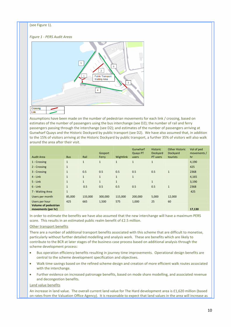
10
(see Figure 1).
Figure 1 - PERS Audit Areas
Assumptions have been made on the number of pedestrian movements for each link / crossing, based on estimates of the number of passengers using the bus interchange (see D2); the number of rail and ferry passengers passing through the interchange (see D2); and estimates of the number of passengers arriving at Gunwharf Quays and the Historic Dockyard by public transport (see D2). We have also assumed that, in addition to the 15% of visitors arriving at the Historic Dockyard by public transport, a further 35% of visitors will also walk around the area after their visit.
Audit Area Bus Rail Gosport Ferry Wightlink
Gunwharf Quays PT users
Historic Dockyard PT users
Other Historic Dockyard tourists
Vol of ped movements / hr
1 - Crossing 1 1 1 1 1 1 4,190
2 - Crossing 1
425
3 - Crossing 1 0.5 0.5 0.5 0.5 0.5 1 2368
4 - Link 1 1 1 1 1 4,165
5 - Link 1 1 1 1 1 3,190
6 - Link 1 0.5 0.5 0.5 0.5 0.5 1 2368
7 - Waiting Area 1 425
Users per month 85,000 133,000 300,000 115,000 200,000 5,000 12,000 Users per hour 425 665 1,500 575 1,000 25 60
Volume of pedestrian movements (per hr) 17,130
In order to estimate the benefits we have also assumed that the new interchange will have a maximum PERS score. This results in an estimated public realm benefit of £2.5 million.
Other transport benefits
There are a number of additional transport benefits associated with this scheme that are difficult to monetise, particularly without further detailed modelling and analysis work. These are benefits which are likely to contribute to the BCR at later stages of the business case process based on additional analysis through the scheme development process:
Bus operation efficiency benefits resulting in journey time improvements. Operational design benefits are central to the scheme development specification and objectives.
Walk time savings based on the refined scheme design and creation of more efficient walk routes associated with the interchange.
Further evidence on increased patronage benefits, based on mode share modelling, and associated revenue and decongestion benefits.
Land value benefits
An increase in land value. The overall current land value for The Hard development area is £1,620 million (based on rates from the Valuation Office Agency). It is reasonable to expect that land values in the area will increase as

11
a result of the public realm measures. An increase of 10% would result in an additional £1.6 million of benefits.
Net GVA benefits
The potential redevelopment of the Brunel House site represents the first opportunity to kick start the regeneration of The Hard area. The proposed development could generate 186 net direct jobs, and a further 82 indirect jobs within the region; equating to a £5.554 million net GVA benefit. Feedback from the developer (see D2 and attached letter of support) indicates that a new interchange will act as a “very powerful and positive signal of the Council’s long term investment and support in the area”, and would reassure the developer of the benefits of progressing with the redevelopment of Brunel House.
It is therefore appropriate to include some of the net GVA benefits within the BCR. A conservative approach has been adopted, based on just 25% of the expected benefits. When applied over a 30 year appraisal year, and converted to 2010 prices and values, this gives a benefit of £19.96 million.
Additional GVA benefits. Relaxing the assumptions about the proportion of net GVA (associated with the redevelopment of Brunel House) to include in the BCR, would substantially increase the value of the BCR. This could be justified as the developer specifically states that “The viability and success of such a project [the redevelopment of Brunel House] is intrinsically linked to the wider gentrification of this area.” Similarly, extending the GVA benefits to other development sites (E8-E12) would substantially increase the scheme BCR. This again can be justified given the identification of the scheme in the Portsmouth Plan as ‘critical infrastructure’, and the views of the business community and developers regarding the importance of public realm improvements in unlocking development (see D2 and attached letters of support).
E2 Where a BCR is unavailable, please use the space below to provide the data requested within the guidance to this question that is not captured elsewhere in this application.
-
E3 What impact is the project expected to have end-to-end journey time?
0->2min reduction N/A
2->5min reduction N/A
=/<5min reduction N/A
Please describe the basis of the expected end-to-end journey time reductions.
No significant change.
E4 Is the project likely to have an impact on the cost of travel? If so, describe briefly what that will be?
No significant change.
E5 Is the project expected to improve journey time reliability?
No significant change.
E6 Is the project expected to improve journey safety?
Yes – The current interchange is poorly designed in terms of passenger safety. The configuration of the space is muddled with pedestrians funnelled along narrow pavements or forced to cross over bus lanes in order to access waiting stands - see also results of PERS Audit (D2). The new interchange will provide a clearer and more accessible layout that works well for both bus and vehicle manoeuvring and for pedestrian and cycle accessibility, and provides a much safer environment. During the 3 years since 2010 there have been 3 serious and 6 slight casualties in The Hard area.
E7 Does the project make better use of existing transport infrastructure or complement / multiply the benefits of existing transport infrastructure / operations?
Yes – Involves modifying the existing road network (limited new construction required), pedestrianisation of existing routes to enhance their functionality, and improvements to an existing interchange location (new bus interchange facility). Some elements of the scheme are already being delivered as part of the PCC LSTF project, e.g. the provision of secure, safe cycle parking and storage facilities; and improvements to the Millennium Walkway that links Gunwharf Quays to the Historic Dockyard via a waterfront route.
Economic Growth Please use the Part B application form (Excel Spreadsheet) for questions E8-E11.
E8 What are the expected employment (direct or indirect) outputs? (Complete the table below and use the space below to provide any explanatory information of the numbers.) Part B

12
The SPD identifies the following opportunity sites as having the potential to deliver at least 300 residential units, 25,000m2 of hotel space, and 20,000 m2 of office floorspace together with lower levels of retail floorspace. While employment is identified as an acceptable use on some of the opportunity sites, there is no guarantee of further employment (business) floorspace being delivered in the SPD area. Floorspace relating to retail, hotel space, and restaurants and cafes would, however, generate their own employment.
Summary of development opportunities (as set out in the SPD)
Opportunity site Site area Preferred mix of uses
1. Ordnance Row Arches N/A A1, A3, and D1
2. College Lane 0.04ha C3
3. The Hard South (Brunel House Site)
0.28ha Ground floor A1 (small-scale), A3 fronting The Hard.
Other ground floors C1, C3. Upper floors C1, C3, D2.
Opportunity for tall, landmark building on corner of The Hard and College Street (15+ storeys).
4. Havant Street 0.21ha Car parking to be retained on site. B1, C1, C3.
5. Clock Street 0.28ha Car parking to be retained on site. B1.
Other acceptable uses: C1, C3, D1 and D2.
6. Queen Street 0.1ha Ground floor A1 (small scale), A3. Upper floors B1, C3.
Other acceptable uses: Upper floors D2.
7. Former Naval Academy N/A C1 (max of 100 beds)
8. Boathouse 4 N/A A1, A3, D1. Other acceptable uses: A1 and D2.
A1 – Shops; A3 - Restaurants and Cafes; B1 – Business; C1 – Hotels and Hostels; C3 - Dwellings, Houses, Flats, Apartments; Class D1 – Non Residential Institutions; D2 – Assembly and Leisure.
A planning application is expected imminently for the redevelopment of the Brunel House site (Site 3 - The Hard South) to accommodate 650 student beds, 220 flats, a 200 bed hotel and ground floor retail units. The land use assumptions in the SPD for this site (60 housing units, 2,500 m2 of hotel space, and 2,500 m2 of office use) have therefore been updated accordingly.
Direct and indirect jobs have been calculated based on floorspace by land use, in accordance with the HCA’s Employment Densities Guide (2010):
Location Use Class Floorspace Employment Density
Gross FTE Jobs
Net FTE Jobs (assuming 50% displacement)
Indirect Jobs
(0.44 regional multiplier)
Site 3. The Hard South
(Brunel House Site)
A1 (high street retail)
1,000 m2 19 m
2 53 26 12
C1 (hotel, 4 or 5*)
6,000 m2
(200 rooms) 1 FTE/
1.25 rooms 160 [160] 70
Sites 1, 2, 4-8 B1 (general office)
17,500 m2 12 m
2 1,458 729 321
C1 (hotel, 3*) 22,500 m2 1 FTE/
2 rooms 250 [250] 55
Sub-Total 47,000 m2 1,921 1,165 513
Net direct and indirect permanent jobs – In the short term, this project will unlock development of the Brunel House Site, generating an estimated 213 permanent jobs. It is assumed, however, that 50% of the retail businesses based at the site would move from elsewhere in the region (rather than be new start-ups or businesses currently based outside the region). However, no displacement of hotel jobs from elsewhere has been assumed given the shortage of hotels in the city. The Portsmouth Hotel Futures Report (2007) showed that there is a need for 12-15 new hotels in Portsmouth, in order to increase the amount of visitors (particularly mid-week) and provide much needed accommodation for business visitors. This results in 186 net permanent jobs.
In addition to the above direct permanent jobs, further indirect jobs would be supported locally and regionally through supply linkage and income multiplier effects, i.e. relating to purchases made as a result of the development and further purchases associated with linked firms alongside the supply chain as well as local expenditure as a result of those who derive incomes from the direct and supply linkage impacts of the

13
development. Composite multipliers for the English Partnerships Additionality Guidance (2008, Table 4.8) have been used to calculate indirect jobs: 0.44 * 186 net regional jobs after 50% displacement = 82 FTE indirect jobs.
Net direct and indirect permanent jobs (Other) – The scheme will also make other sites in the area more attractive to investors and developers. Indicative floor allocations for the remaining sites suggest an estimated 1,708 gross jobs or 979 net jobs, plus an additional 431 indirect jobs.
Construction jobs (direct)
In accordance with the guidance from the LTB, the estimate of construction jobs is based on 12.5 FTE jobs for every £1 million spend on physical infrastructure:
Estimated cost of constructing the new interchange = £4.282 million. Jobs = 53 FTE jobs over 15 months.
Indirect jobs related to construction
In addition to the above construction jobs, further indirect jobs would be supported locally and regionally through supply linkage and income multiplier effects. This includes local firms supplying construction materials and equipment and construction workers spending part of their wages in the local economy. Assuming a composite multiplier of 0.44 at the regional level (English Partnerships Additionality Guide, Third Edition, 2008), the construction of the scheme could indirectly support a further 23 jobs regionally (0.44*53).
Total Jobs
Total jobs created (direct or indirect) 1,165 net jobs (186 at Brunel House Site, 979 at other sites)
Total Jobs safeguarded 513 net jobs (82 at Brunel House Site, 431 at other sites)
Total construction Jobs created 53 FTE direct jobs + 23 indirect jobs across the region, over 15 months (Apr 15 – Jun 16)
Total new jobs 1754
E9 Identify the expected total employment floorspace that the transport project will support (directly or indirectly). Provide the total number, and use the space provided to explain how the transport project will support the employment floorspace.
Total employment floorspace 47,000m2 (see above)
In the short term, this project will unlock approx. 7,000 m2 of retail and hotel floor space at the Brunel House
Site (planning application is imminent). In addition, a further 40,000 m2 of employment floorspace could be
unlocked at other sites (based on indicative allocations in the SPD), however, at most sites a range of uses is permitted including C3 housing (see E8).
E10 How many housing starts is the transport project expected to support (directly or indirectly). Provide the total number, and use the space provided to explain how the transport project will support the housing starts.
Total housing starts 1,110 student beds and flats.
In the short term, this project will unlock 650 student beds and 220 flats at the Brunel House Site (planning application is imminent). In addition the SPD allows for at least 240 further units (200 – 60 at the Brunel House site).
E11 Identify the expected GVA impact of the transport project.
Construction stage GVA £1.584 million.
GVA per capita Based on net jobs
£62.709 million (£5.554 million, Brunel House; £57.155 million, rest of The Hard)
E12 Describe any wider economic benefits expected to contribute to the overall value for money of the project.
Strengthen visitor and retail economy in the Harbour Area
Improvements in The Hard Area will have positive impacts on maintaining the role of Gunwharf Quays and enhancing the appeal of Portsmouth’s visitor attractions; and encourage new retail and catering opportunities for visitors. This will result in more trips and higher levels of average spend. Despite being a popular destination, Portsmouth does not fulfil its vast potential for visitors given the breadth and quality of its attractions. Average spend per visit is only £49/person/day, compared with £65/person/day in other comparable cities (Portsmouth Western Corridor Problems and Issues Report (2009).
May 2013 saw the opening of the new Mary Rose Museum in Portsmouth Historic Dockyard as a world-class attraction. An even greater number of international and domestic visitors are expected to visit Henry VIII’s flagship. Improving the attractiveness of the interchange will encourage more visitors and greater use of public transport, limiting the negative impacts of congestion on the wider economy.

14
Increase the attractiveness of Portsmouth
Will help increase the attractiveness of Portsmouth as somewhere to live and work will help attract highly skilled employees and high value businesses to Portsmouth, as well as providing employment opportunities for existing residents. Many employers report that high qualified employees do not see Portsmouth as a desirable place to live and work and a location outside Portsmouth helps them attract higher calibre staff (based on evidence collated for PCC LSTF bid).
Address the lack of attractive hotel provision within the City
The Portsmouth Hotel Futures report has shown that there is a need for 12 - 15 new hotels in Portsmouth. Part of this need could be met through a 4 star hotel of 200 or more bedrooms with extensive conference and exhibition facilities, located in the city centre. This would increase the amount of visitors, particularly mid-week (most tourists are day visitors, despite the wealth of attractions in the City), and provide much needed accommodation for business visitors. Improvements to the interchange, as part of wider public realm and development proposals for the area will help unlock opportunities for hotel development and meet the identified need.
Local Environment
E13 Explain the impact of the project on emissions from transport and disturbance from noise. What impact will this will have on the local area?
Beneficial impact on carbon emissions - The Sustainability Appraisal Report for The Hard SPD (Nov 2010) concluded that the new interchange will make public transport more attractive, public realm improvements will make walking and cycling easier and safer, whilst encouraging residential development will add city centre homes close to services and facilities, therefore reducing the need to travel. Furthermore, the design principles in the SPD will encourage the use of sustainable and recycled materials during construction, support inbuilt recycling facilities and general sustainable design principles. This will minimise the emissions associated with embedded carbon.
Moderate beneficial impact on local air quality - Positive benefits for AQMA 11 by encouraging greater use of public transport to access The Hard area and reducing levels of traffic on this route. Will also deliver benefits for Queen Street (formerly AQMA 12, but now revoked), which is located between The Hard and the City Centre.
Slight beneficial impact on noise - The introduction of street trees and more efficient bus movements will help make streets feel quieter and calmer.
E14 What is likely to be the overall impact on the natural environment?
The Sustainability Appraisal Report for The Hard SPD (Nov 2010) considers the impact of the interchange and development proposals on flood risk, natural resources, and biodiversity.
Flood Risk (neutral) - Design principles in the SPD encourage and support development that will reduce water consumption and surface run off.
Biodiversity (neutral) - The Hard SPD has no significant impact on this objective. A habitats regulations screening statement confirmed that there was no need to conduct a full AA on the SPD, as there were unlikely to be significant effects. The final version of the Hard SPD includes a recommendation for development to enhance biodiversity through living surfaces, nesting opportunities and amenity planting.
Natural resources (possible beneficial effect) - Design principles in the SPD will encourage the use of sustainable and recycled materials during construction, support inbuilt recycling facilities and general sustainable design principles.
E15 What is likely to be the overall impact on streetscape and/ or the urban environment?
Large beneficial – The poor quality townscape in the area is the main reason for producing the SPD. Design principles within the SPD will require high quality additions to the built environment which will in turn increase the attractiveness and perception of the area, which is currently at quite a low level.
In accordance with the SPD, the materials used in a new bus interchange building will be predominantly toughened glass to provide a highly visible, well lit and safe environment in which passengers can wait. To ensure that the building does not affect views or detract from the ‘open’ character of the area, the building will be a low level (1 to 2 storeys) structure with potential to accommodate travel information, ticket purchase facilities and secure, covered cycle storage.
The Sustainability Appraisal Report for The Hard SPD (Nov 2010) concluded that improvements to the quality of

15
the public realm, interchange and cultural offer may assist in reducing the impact of noise and anti social behaviour perceived as a problem in the area (as identified through consultation undertaken in 2009 and 2010). A safer, well lit and well managed interchange will help to reduce the fear of crime, whilst additional public spaces being well used add opportunities for natural surveillance.
Section F: The Financial Case
F1 What is the total cost of the project?
Total Estimated Cost = £6.8 million
Finalise detailed design work/prepare and submit planning permission / prepare business case, etc £51,500*
Improvement works to core deck structure - Stabilisation and enhancement of piled deck supporting new interchange
£515,000
Surfacing works to deck / new public realm - including timber deck, hardwood, Yorkstone paving, tarmac, sand/gravel treatment and trees
£1,129,910
Architectural lighting scheme across interchange building, key passenger routes and public space £154,500
New interchange building - Passenger waiting facility to include retail kiosks £2,060,000
Travel information £216,300
Edge treatment to deck - Replacing existing shelter with maritime feature adjacent to HMS Warrior £206,000
Commuted sum for ongoing maintenance £618,000
SUB-TOTAL £4,951,210
15% professional / management fees £742,682
SUB-TOTAL £5,693,892
20% risk contingency £1,138,778
TOTAL £6,832,670
The above estimate is based on unit rate based costs obtained in 2010 for The Hard Masterplan, inflated by 3% to convert to 2013 prices. The % applied for ‘professional / management fees’ reflects the fact that a lot of the standard fees (legal, procurement, etc) will be subsumed internally as a Council project.
The risk contingency applied reflects the fact that the construction cost has been benchmarked against a similar interchange in Hyde, which cost £3.6m in 2006, but would not have had deck structure costs.
A full quantified risk assessment will be undertaken and maintained as part of the on-going scheme operation work. A value engineering process will also be important in managing down the costs.
* Since the submission of the original proforma in June, we have increased and secured an additional budget to cover design work, consultation and engagement, preparation and submission of planning application, producing a business case, etc. These activities were not fully captured in the original proforma, and have increased the Council’s local contribution to the scheme by £390,000.
F2 What is the capital funding request from the LTB?
£4. 832 million
F3 What percentage of the total transport project cost is the LTB request?
71%
F4 How is the remainder of the transport project cost to be funded?
From PCC’s current corporate reserves.
F5 Set out the indicative funding profile in the table below
£m <2015-16 2015-16 2016-17 2017-18 2018-19 >2018-19 Total
LA Capital £2,000,000 £2,000,000
LTB Capital Funding Sought
£4,832,670 £4,832,670

16
Total £6,832,670 £6,832,670 *It is likely that some of the LA Capital for 2015/16 would be bought forward to enable work to commence on maintenance and other each construction activities.
F6 Will the project require ongoing revenue support? If so, how will this be funded?
The interchange will require ongoing revenue support to maintain the building and quality public realm, as well as the provision of travel information systems. This will primarily be funded from two streams - the collection of departure charges from excursion and national coach operators, and rental income from retail concessions. In 2012, the coach departure charges totalled approximately £87,000. This will reduce in 2013 by approximately £10,000 with Greyhound no longer running services. The annual rental income from the existing kiosks and café at the interchange was £45,000 in 2012, however we would anticipate this figure increasing for the new interchange, given the higher quality of outlet that would be provided. A commuted sum within the funding bid will also be held by Colas for ongoing repairs and maintenance of the roads and footpaths.
F7 Would funding awarded to this project comply with European State Aid regulations?
Yes, funding will be used directly by Portsmouth City Council to deliver the interchange scheme only.
Loan Applications
F8 Please list the source(s) of loan repayment.
N/A
F9 Please set out the preferred loan repayment term.
N/A
Section G: The Management Case
G1 Is the scheme deliverable within the 2015-19 period? If not, when will the project be delivered and will LTB funds be spent within the 2015-19 period?
Yes, providing funding is successfully secured with notification provided imminently. See programme below (G6). Our programme is based on:
Design work and preparation of an outline business case by April 2015, followed by detailed design and a full business case by Jul 2014 (timescales to be confirmed with LTB) – we have identified appropriate resources to undertake these activities (see G4 and G6);
Planning approval by early 2015 – The risk of not getting planning permission is considered ‘very low’ given that there is already an existing bus station on the site.
Construction in 2015/16 – Evidence from elsewhere, as well as our recent experience in delivering a new interchange building and facilities at Tipner Park & Ride site suggests that a 12 month timescale is feasible: - We have been in touch with client contacts at Luton BC who have recently created a new bus
interchange to tie-in with the Busway scheme. They had a construction period of about 18 months from start to finish but that was intermittent construction alongside the construction of the busway. It was considered that a 12 month timescale for construction of the interchange only could easily have been achieved. The Luton bus station has 13 bus bays plus 2 additional layover bays and a separate area for rail replacement services. The bus station includes provision for articulated buses.
- Hyde Interchange (see G9) took 10 months to build and involved a similar construction to that envisaged for The Hard.
We are currently in discussions with our procurement team regarding procurement routes and timescales. There is sufficient time within the programme to procure a contractor through a traditional OJEU approach, involving: PQQ in Feb 2014 to determine shortlist; tender in June – July 2014; evaluation and appointment by Oct 2104; two month mobilisation, enabling work to commence from Jan 2015 onwards. There would also be sufficient time for a design and build approach, but this may result in a more a complex in terms of ensuring that bus operators are closely involved in the detailed design of the scheme. The main bus operators are supportive of a revised scheme and we are working with them to ensure that their requirements can be met within the timescales. We are meeting with both operators in September 2013. Each operator has been asked to provide information on how their aspirations for developing the network and improving the timetable are expected to change once the interchange opens.
17
G2 Is the scheme on the Strategic Road or Rail network? If yes, does the relevant infrastructure owner support this scheme and committed to its delivery within the 2015-19 period.
The scheme is not on the strategic road network. However, the Highways Agency provided the following feedback to the 2010 consultation, “Do not wish to comment on Hard SPD, however look forward to continued involvement in Development Plan Documents”.
The interchange scheme is adjacent to Portsmouth Harbour Station. Network Rail provided the following feedback to the 2010 consultation, “In principle, Network Rail is supportive of the plans to improve access to station. Enhancing public realm will make station more enjoyable and safe environment. Detailed plans should not affect operational effectiveness of railway and should be discussed with Network Rail at earliest opportunity”.
G3 Does the scheme impact on public transport operations? If yes, are public transport operators supportive of the scheme?
Yes. Public transport operators were consulted on the scheme design and were broadly supportive. There is some differing opinion on the size of the interchange needed (e.g. in terms of number of bays). The current design is sufficient for the current / future buses arrivals, but does not have sufficient capacity to accommodate buses which are out of service for periods during the day. As part of the detailed design of the scheme, we will therefore consider options for changing the design to accommodate the requirements of the bus operators. A letter of support from Stagecoach is provided in Appendix B.
Letters of support from Network rail and Gosport Ferry are also included in Appendix B. Improvements to the interchange will improve integration between bus, rail and ferry operations.
G4 Demonstrate the design and implementation resources that will be in place to develop and deliver this project. Also confirm who the senior officer responsible for the delivery of the project will be.
A new Project Manager (Anna Turner) has been appointed to oversee the development and delivery of the scheme, and a project team is currently being put together. Our framework partner, Atkins, is currently putting together a proposal for preparing the business case and undertaking key stages in the scheme development and design phase. A Project Board is being set up to oversee delivery of the scheme, comprising the key operators using the interchange and local business interests. Network Rail has also agreed to sit on the Board, which will ensure close integration between the objectives for The Hard Interchange and Portsmouth Harbour station.
PCC is able to draw on the expertise and resources of:
its Asset Management Service (AMS) which incorporates a wide range of property professionals including Architects, Building Surveyors, Quantity Surveyors and evaluators;
its PFI Highway contractor, Colas; and
its term consultants Atkins and Amey, who are able to provide the full range of skills required to develop and deliver this scheme.
The programme provided in G6 shows who will be responsible (to be confirmed) for undertaking key elements of the programme. Atkins has already been asked to submit a proposal for preparing the business case; and bus operators have been asked to provide information on how their aspirations for developing the network and improving the timetable once the interchange opens.
Senior Responsible Officer: Simon Moon.
G5 Confirm your commitment to maintain the asset post delivery.
A commuted sum is included within the funding bid to be held by Colas for ongoing repairs and maintenance.
G6 Set out the high level project stages.

18
G6 - Programme for delivery
The may be scope to bring some maintenance and construction work forward to 2014/15. The Hard Programme (20130905)_SE,JB suggestions4.pdf

19
The Management Case (cont’d)
G7 Is the project likely to be publically acceptable?
Yes. Respondents to consultation undertaken in 2009 were asked “what are the most urgent changes you would like to see made in the area?” Improvements to the transport interchange were amongst the priorities for change, specifically:
modernise interchange or move it elsewhere in the area – improve layout for commuters and pedestrians, remove railings and reduce taxi rank / better passenger facilities and waiting areas;
improve access to Gosport ferry for pedestrians and cyclists;
improve links and signposting between the Dockyard, rail station and Gunwharf / improve general signage in the area.
Similarly, respondents to consultation undertaken in 2010, identified an urgent need for:
new bus interchange / better passenger facilities and sheltered areas
better co-ordinated transport facilities
remove taxi drivers who obstruct pedestrians and cyclists.
Mike Gannon, Department for Transport, provided the following feedback, “Support the approach shown in SPD.”
G8 Has any consultation taken place or is any planned? If so, please summarise.
Yes. In February 2009, stakeholders and the public were consulted on the vision for The Hard. They were also asked to identify the key problems in The Hard area; suggest how the area could be improved for pedestrians and cyclists, and tourists and visitors; provide feedback on proposals for pedestrianising part of the area; and suggest alternative routes which vehicles should take. 85 people responded, and their views were used to inform the draft Maserplan. (http://www.portsmouth.gov.uk/media/The_Hard_Issues_and_opportunties_-_questionnaire_responses.pdf)
Consultation also took place on a draft version of the Masterplan between January and March 2010. 93 responses were received. (http://www.portsmouth.gov.uk/media/Questionnaire_responses.pdf)
G9 Has the project been successfully delivered elsewhere, and how transferable is the project to the Solent area?
New public transport interchanges have been successfully delivered across the UK and have often been catalysts for investment and a key factor in regeneration programmes. These objectives are equally applicable and transferable to The Hard interchange project in Portsmouth. The successful delivery of a modern, accessible and integrated transport hub in this location is essential to supporting Portsmouth as a great waterfront city and gateway destination. Below are some examples of new interchange projects within the UK that provide examples of good practice that The Hard interchange can assess and incorporate:
Norwich Bus Station, Norfolk County Council - Construction cost: £5.3m, completed July 2005 - With 6 million passengers per year the bus station has been part of the regeneration of the city of Norwich. The design incorporates a freestanding steel canopy with aluminium panels and translucent fabric in tension. Glass enclosures protect passengers from the weather and the bus station has removed 1,200 buses per day from on street bus stops. The award winning, landmark building is an integral part of a larger regeneration and transportation strategy including a hotel, offices and housing. The bus station has been the catalyst for the development of a socially and commercially important, but run down area of the city. A focal point of the facility is the Travel Centre that provides comfortable space for waiting, travel information and refreshment.
Hyde, Transport for Greater Manchester - Construction cost: £3.6m, completed August 2007 - The new bus station is a modern, fully enclosed structure with glazed walls and automatic doors to all entrances and exits, and comprises four double and two single bus stands. A walk in Travelshop, retail outlet and a supervisor's office are also provided, together with fully accessible public toilets. The station is brightly lit with clearly defined pedestrian crossing points and anti-graffiti paint systems. The adjoining taxi rank was also fully upgraded with a new sheltered waiting area. The new facility was just one of a number of projects contributing to regeneration within the borough and demonstrated the vital role of sustainable travel links in providing access to jobs, education, retail and leisure opportunities.
Mansfield, Nottinghamshire County Council - Construction cost: £9m, completed March 2013 - The new state of the art bus station is a fully enclosed building offering a more relaxed and safer waiting environment. There are 16 departure bays with boarding controlled by automatic doors opening only when the bus has arrived. The

20
facility also incorporates a travel information centre, café, shop, electronic information displays and fully accessible public toilets. A new high level public footbridge offers direct access to the adjacent Mansfield rail station. The new bus station is part of a package of improvements that Nottinghamshire CC and Mansfield DC are delivering to encourage swifter, greener travel across the county.
Hyde Interchange
G10 Set out the key risks associated with the project.
Risk Likelihood (RAG)
Impact (RAG)
Comment / Mitigation
The condition of the deck on which the current interchange sits is unknown.
(Addressed)
Low High A special inspection of the deck structure was carried out in August 2013, involving on-site visual examination; chisel probing; light hammer sounding tests; piling inspection; concrete core samples; and other tests to determine the condition of the structure. The visual inspection of the structure indicates that the structure is generally in good condition. Some maintenance work is required, as part of the development of a new interchange, including re-waterproofing of the deck.
Bus operators / taxi operators no longer buy into scheme or oppose detailed design.
Low Medium Bus and taxi operators have already indicated their support for the interchange improvement, at the time of the SPD preparation. Recent letters of support are provided in Appendix B.
The Council will engage with bus and taxi operators on an on-going basis during scheme development and delivery.
Brunel House site does not get planning permission, or does not progress, resulting in no CIL contribution for match funding.
(Addressed)
Low High Funding has now been secured from corporate reserves.
Bus operations will be disrupted during construction which may have a negative impact on bus use
High Medium The project timetable includes a period for implementing interim bus measures in advance of construction. These will be discussed and agreed in advance with the operators to minimise disruption.
Increase or delay in diversion of services impacting on programme or costs
Medium Medium Ensure formal agreement of works in place during early part of delivery programme. Undertake ground radar surveys during the design stage. Continue dialogue with utility companies and obtain programmes and their commitment. Undertake advanced works if feasible.
Changes to design after construction has commenced
Medium Medium Include float within construction programme, early engagement with third parties and pro-actively operate the NEC early warning process.
Section H: The Commercial Case
H1 What investment will this scheme lever in?
Bouygues Development, the UK property development arm of Bouygues Construction is currently working with Portsmouth City Council to bring forward the development of Brunel House, a large mixed-use regeneration project on the Hard with a Gross Development Value in the region of £100 million (see Appendix B1 for letter of

21
support). A planning application is expected shortly. Other developers are also likely to come forward as a result of improvements to the area (see Appendix B, for example).
H2 What is the public investment private investment ratio?
14:1 (£100 million / £7.152 million, based on private sector investment in Brunel House)
Section I: Monitoring & Evaluation
I1 Can the scheme be measured against these KPIs?
Net additional jobs created (directly or indirectly) or safeguarded in the Solent LTB area that can reasonably be linked to the transport intervention.
Yes No
Net additional housing or employment floorspace enabled as a consequence of the transport intervention (either directly or as part of a wider package of enabling measures).
Yes No
Private sector investment leveraged as a result of the delivery of the transport scheme (either directly or as part of a wider package of enabling measures).
Yes No
Local Gross Value Added (GVA) created or safeguarded.
Yes No
I2 Provide a short summary of how you will monitor and evaluate this project.
The following indicators will be monitored, in accordance with the Annual Monitoring Report required as part of the Portsmouth Plan monitoring frameworks for PCS4 – City Centre and PCS17 – Transport, as set out in the Portsmouth Plan:
Number / proportion of trips made by non car modes.
Non residential development in high accessibility zones.
Amount of new employment floorspace and housing provided.
Quantitative and qualitative assessment of development.
Private sector investment.
Section J: Declarations
J1 Senior Responsible Owner As Senior Responsible Owner for The Hard Interchange Scheme I hereby submit this request for prioritisation to the LTB on behalf of Portsmouth City Council and confirm that I have the necessary authority to do so. I confirm that I have read the supporting guidance and that Portsmouth City Council have the resources in place to develop a full transport business case should this proposal be short-listed and that Portsmouth City Council will have all the necessary statutory powers in place and resource to ensure the timescales in the application can be realised.
Name Simon Moon
Signed
Position Head of Transport &
Environment Date 20
th Sep 2013
2nd Oct 2013 (update)