utah 2016 - washington county aoi ql2 lidar project report
TRANSCRIPT
Contract # AV2408
Submitted: September 22, 2017
Quantum Spatial, Inc523 Wellington Way, Suite 375Lexington, KY 40503859-277-8700
Prepared by:
Utah 2016 - Washington County AOIQL2 LiDAR Project Report

September 22, 2017Page ii of iiiUtah 2016 - Washington County AOIQL2 LiDAR Project
Project Report
Contents1. Summary / Scope ...............................................................................................................................................1
1.1. Summary .................................................................................................................................................11.2. Scope ......................................................................................................................................................11.3. Coverage ...............................................................................................................................................11.4. Duration .................................................................................................................................................11.5. Issues .....................................................................................................................................................21.6. Deliverables .........................................................................................................................................2
2. Planning / Equipment ..................................................................................................................................... 42.1. Flight Planning ................................................................................................................................... 42.2. LiDAR Sensor ..................................................................................................................................... 42.3. Aircraft .................................................................................................................................................72.4. Base Station Information .................................................................................................................72.5. Time Period .........................................................................................................................................8
3. Processing Summary .......................................................................................................................................93.1. Flight Logs ...........................................................................................................................................93.2. LiDAR Processing ............................................................................................................................103.3. LAS Classification Scheme ............................................................................................................. 113.4. Classified LAS Processing .............................................................................................................. 113.5. Hydro-Flattened Breakline Processing ...................................................................................... 123.6. Hydro-Flattened Raster DEM Processing .................................................................................. 123.7. First Return Raster DSM Processing ........................................................................................... 123.8. Intensity Image Processing ........................................................................................................... 13
4. Project Coverage Verification ..................................................................................................................... 145. Ground Control and Check Point Collection ............................................................................................ 16
5.1. Calibration Control Point Testing ................................................................................................. 165.2. Point Cloud Testing ......................................................................................................................... 165.3. Digital Elevation Model (DEM) Testing ...................................................................................... 17
September 22, 2017Page iii of iiiUtah 2016 - Washington County AOIQL2 LiDAR Project
Project Report
List of FiguresFigure 1. Project Boundary ..................................................................................................................................3Figure 2. Planned Flight Lines ............................................................................................................................5Figure 3. Leica ALS 70 80 LiDAR Sensors ......................................................................................................6Figure 4. Some of Quantum Spatial’s Planes ..................................................................................................7Figure 5. Flightline Swath LAS File Coverage .............................................................................................. 15Figure 6. Calibration Control Point Locations .............................................................................................. 18Figure 7. QC Checkpoint Locations - NVA .................................................................................................... 19Figure 8. QC Checkpoint Locations - VVA ................................................................................................... 20
List of TablesTable 1. Originally Planned LiDAR Specifications ...........................................................................................1Table 2. Lidar System Specifications ................................................................................................................6
List of AppendicesAppendix A: GPS/IMU Statistics, Flight Logs

September 22, 2017Page 1 of 20Utah 2016 - Washington County AOIQL2 LiDAR Project
Project Report
1.1. Summary
This report contains a summary of the Utah 2016 - Washington County LiDAR acquisition task order, issued by State of Utah, Department of Technology Services, Division of Integrated Technology, Automated Geographic Reference Center (AGRC) under their contract signed on August 12, 2016. The task order yielded a project area covering 7,536 square miles over western Utah and southern Idaho. The intent of this document is only to provide specific validation information for the data acquisition/collection work completed as specified in the task order.
1.2. Scope
Aerial topographic LiDAR was acquired using state of the art technology along with the necessary surveyed ground control points (GCPs) and airborne GPS and inertial navigation systems. The aerial data collection was designed with the following specifications listed in Table 1 below.
Table 1. Originally Planned LiDAR Specifications
Average Point Density
Flight Altitude (AGL)
Field of ViewMinimum Side
OverlapRMSEz
2 pts / m2 2,100 m 40° 30% ≤ 10 cm
1. Summary / Scope
1.3. Coverage
The total LiDAR project boundary covers approximately 7,536 square kilometers. This report focuses on the QL2 Washington County area of interest, which covers approximately 1,337.5 square kilometers. This AOI includes partial coverage of Washington County in southern Utah.
A buffer of 100 meters was created to meet task order specifications. LiDAR extents are shown in Figure 1.
1.4. Duration
LiDAR data was acquired from January 8, 2017 to July 14, 2017 in fourteen total lifts. See “Section: 2.5. Time Period” for more details.

September 22, 2017Page 2 of 20Utah 2016 - Washington County AOIQL2 LiDAR Project
Project Report
1.5. Issues
There were no issues to report with this project.
1.6. Deliverables
The following products were produced and delivered:
• Raw LiDAR point cloud data swaths in LAS 1.4 format• Classified LiDAR point cloud data, tiled, in LAS 1.4 format• Hydro-flattened breaklines in Esri shapefile format• 0.5-meter hydro-flattened bare-earth raster DEM, tiled, in ERDAS .IMG format• 0.5-meter first return raster DSM, tiled, in ERDAS .IMG format• 0.5-meter intensity images, tiled, in GeoTIFF format• Processing boundary in Esri shapefile format• Tile index in Esri shapefile format• Calibration and QC checkpoints in Esri shapefile format• Accuracy assessment in .XLSX format• Project-, deliverable-, and lift-level metadata in .XML format
All geospatial deliverables were produced in NAD83 (2011) UTM Zone 12, meters; NAVD88 (GEOID12B), meters. All .LAS tiled deliverables have a tile size of 1,000 meters x 1,000 meters. All other tiled deliverables have a tile size of 2,000 meters x 2,000 meters. All tile names follow US National Grid naming conventions. Tile names are based on the southwest corner of the tile.

September 22, 2017Page 3 of 20Utah 2016 - Washington County AOIQL2 LiDAR Project
Project Report
Figure 1. Project Boundary

September 22, 2017Page 4 of 20Utah 2016 - Washington County AOIQL2 LiDAR Project
Project Report
2. Planning / Equipment
2.1. Flight Planning Flight planning was based on the unique project requirements and characteristics of the project site. The basis of planning included: required accuracies, type of development, amount / type of vegetation within project area, required data posting, and potential altitude restrictions for flights in project vicinity.
Detailed project flight planning calculations were performed for the project using Leica MissionPro planning software. The entire target area was comprised of 200 planned flight lines measuring approximately 1,751 total flight line miles (Figure 2).
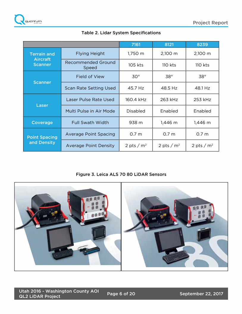
2.2. LiDAR Sensor
Quantum Spatial utilized a Leica ALS 70 serial number 7161, and two Leica ALS 80 LiDAR sensors, serial numbers 8239 and 8121, during the project (Figure 3).
The Leica ALS 70 system is capable of collecting data at a maximum frequency of 500 kHz, which affords elevation data collection of up to 500,000 points per second. The system utilizes a Multi-Pulse in the Air option (MPIA). The sensor is also equipped with the ability to measure up to 4 returns per outgoing pulse from the laser and these come in the form of 1st, 2nd, 3rd and last returns. The intensity of the returns is also captured during aerial acquisition.
The Leica ALS 80 system is capable of collecting data at a maximum frequency of 1,000 kHz. The system utilizes a Multi-Pulse in the Air option (MPIA). The sensor is also equipped with the ability to measure up to 6 returns per outgoing pulse from the laser. The intensity of the returns is also captured during aerial acquisition.
A brief summary of the aerial acquisition parameters for the project are shown in the LiDAR System Specifications in Table 2.

September 22, 2017Page 5 of 20Utah 2016 - Washington County AOIQL2 LiDAR Project
Project Report
Figure 2. Planned Flight Lines
September 22, 2017Page 6 of 20Utah 2016 - Washington County AOIQL2 LiDAR Project
Project Report
Table 2. Lidar System Specifications
7161 8121 8239
Terrain and AircraftScanner
Flying Height 1,750 m 2,100 m 2,100 m
Recommended Ground Speed
105 kts 110 kts 110 kts
ScannerField of View 30° 38° 38°
Scan Rate Setting Used 45.7 Hz 48.5 Hz 48.1 Hz
LaserLaser Pulse Rate Used 160.4 kHz 263 kHz 253 kHz
Multi Pulse in Air Mode Disabled Enabled Enabled
Coverage Full Swath Width 938 m 1,446 m 1,446 m
Point Spacing and Density
Average Point Spacing 0.7 m 0.7 m 0.7 m
Average Point Density 2 pts / m2 2 pts / m2 2 pts / m2
Figure 3. Leica ALS 70 80 LiDAR Sensors

September 22, 2017Page 7 of 20Utah 2016 - Washington County AOIQL2 LiDAR Project
Project Report
2.3. Aircraft
All flights for the project were accomplished through the use of customized planes, three Cessna Caravan (single-turboprop) aircraft, Tail Numbers: N208NR, N604MD and N704MD. These aircraft provided an ideal, stable aerial base for LiDAR acquisition. These aerial platforms has relatively fast cruise speeds which are beneficial for project mobilization / demobilization while maintaining relatively slow stall speeds which proved ideal for collection of high-density, consistent data posting using a state-of-the-art Leica LiDAR systems. Some of Quantum Spatial’s operating aircraft can be seen in Figure 4 below.
Figure 4. Some of Quantum Spatial’s Planes
2.4. Base Station Information
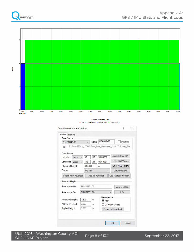
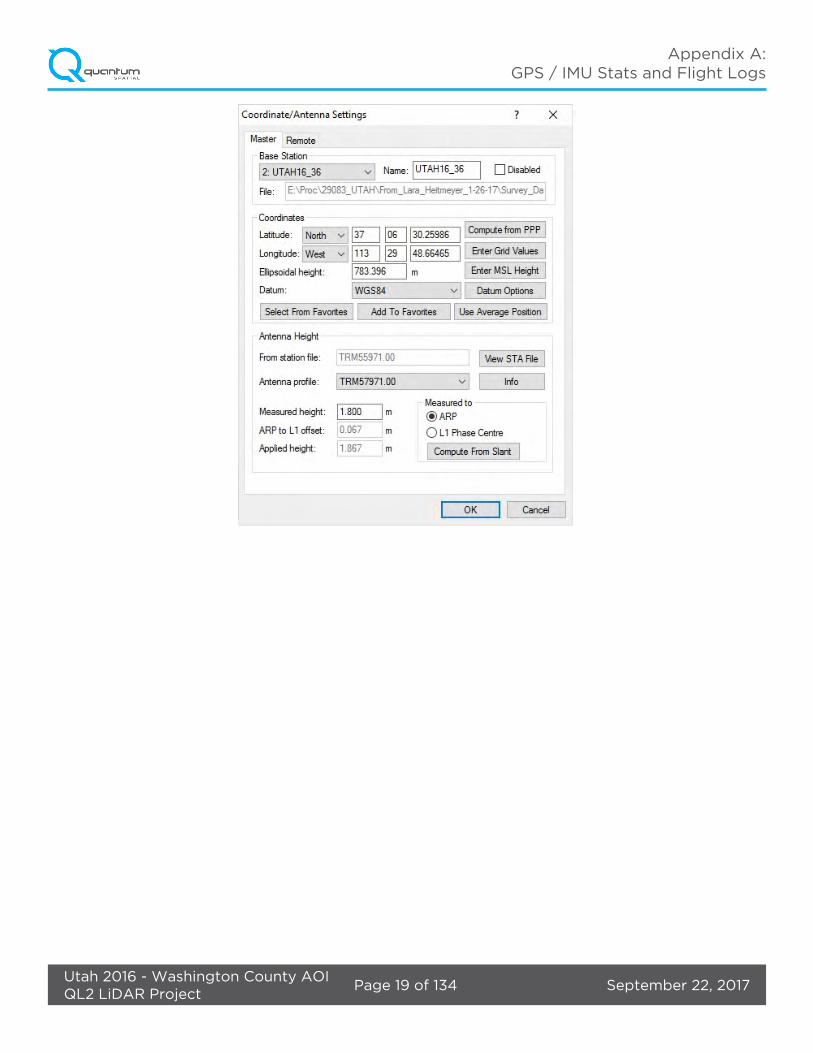
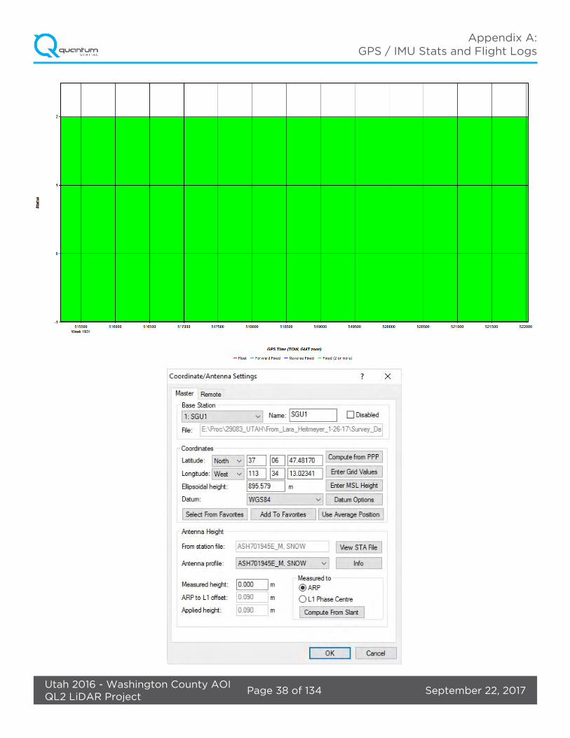
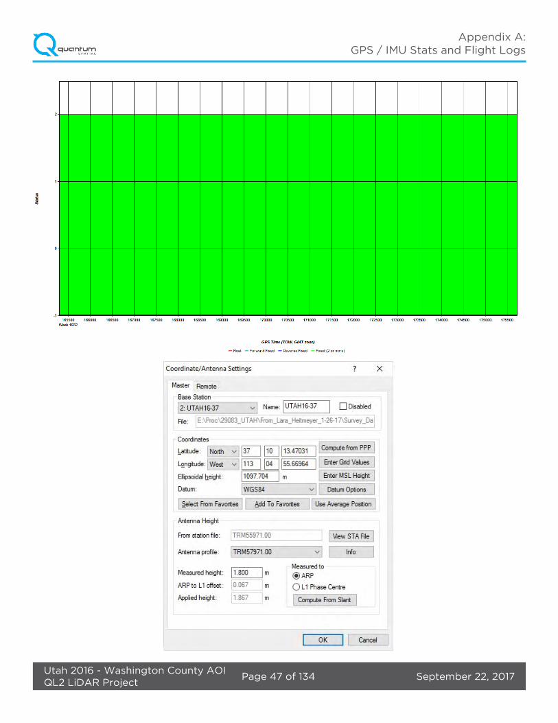
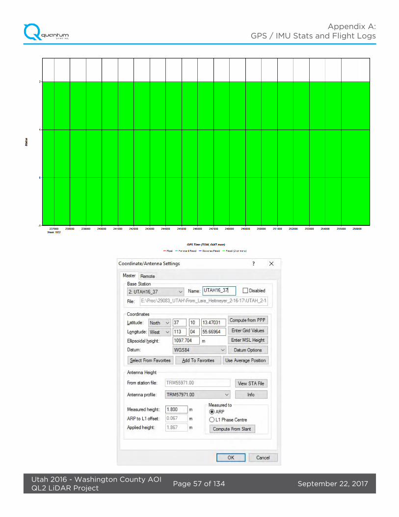
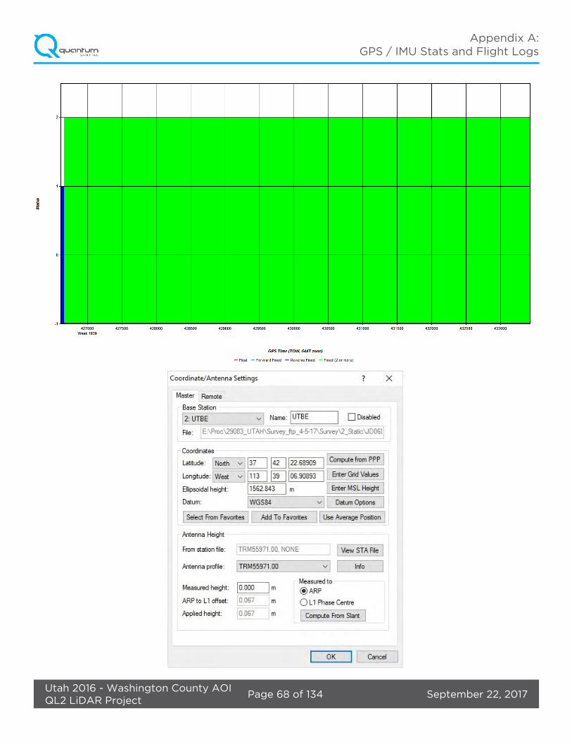
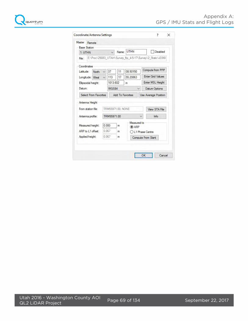
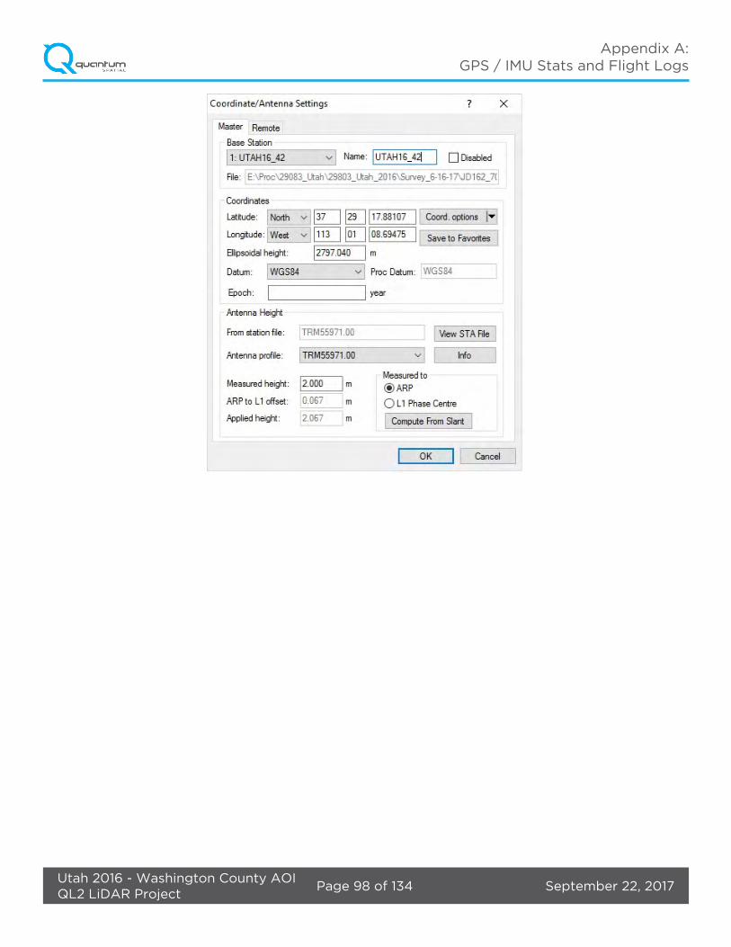
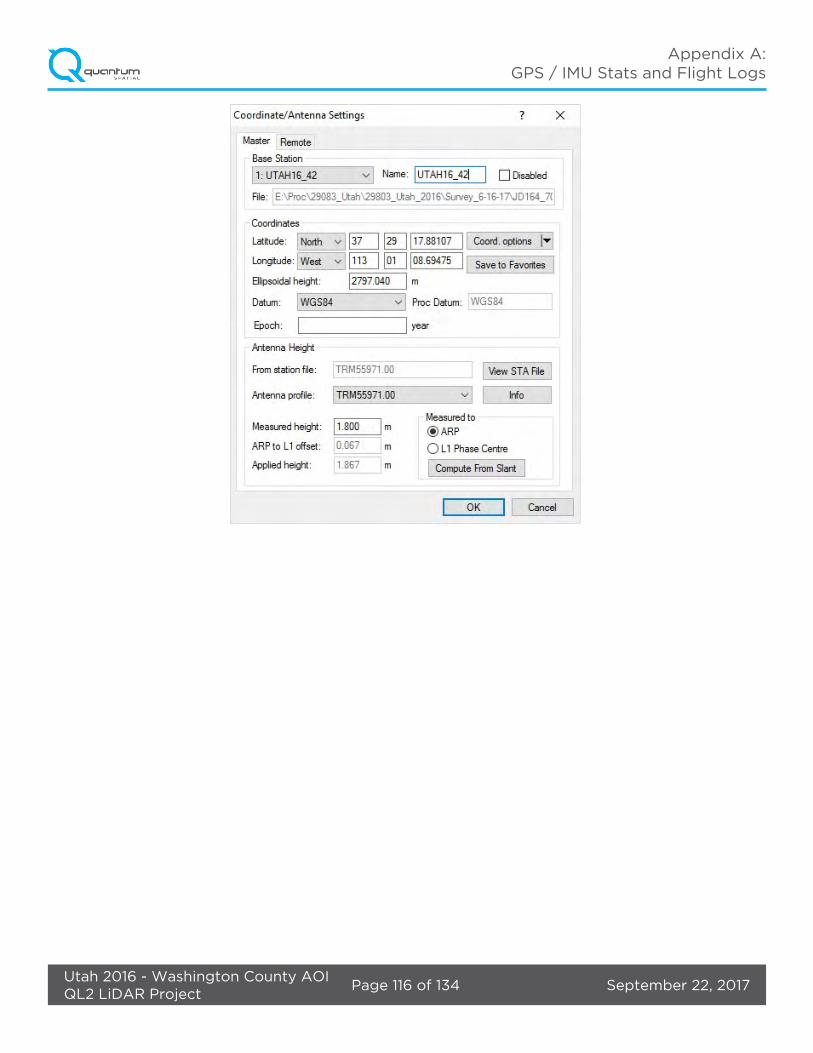
GPS base stations were utilized during all phases of flight. The base station locations were verified using NGS OPUS service and subsequent surveys. Base station locations, data sheets, graphical depiction of base station locations or log sheets used during station occupation are available in Appendix A.

September 22, 2017Page 8 of 20Utah 2016 - Washington County AOIQL2 LiDAR Project
Project Report
• Jan 8, 2017-A (N604MD, SN8239)
• Jan 10, 2017-A (N604MD, SN8239)
• Jan 10, 2017-B (N604MD, SN8239)
• Jan 13, 2017-A (N604MD, SN8239)
• Jan 16, 2017-A (N208NR, SN8239)
• Jan 17, 2017-A (N208NR, SN8239)
• Mar 9, 2017-A (N704MD, SN8121)
• Mar 9, 2017-B (N704MD, SN8121)
• Mar 10, 2017-A (N704MD, SN8121)
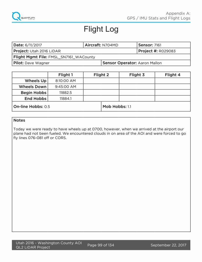
• Jun 11, 2017-A (N704MD, SN7161)
• Jun 13, 2017-A (N704MD, SN7161)
• Jun 13, 2017-B (N704MD, SN7161)
• Jun 14 2017-A (N704MD, SN7161)
• Jul 14, 2017-A (N704MD, SN8239)
2.5. Time Period
Project specific flights were conducted over several months. Fourteen sorties, or aircraft lifts were completed. Accomplished sorties are listed below.
September 22, 2017Page 9 of 20Utah 2016 - Washington County AOIQL2 LiDAR Project
Project Report
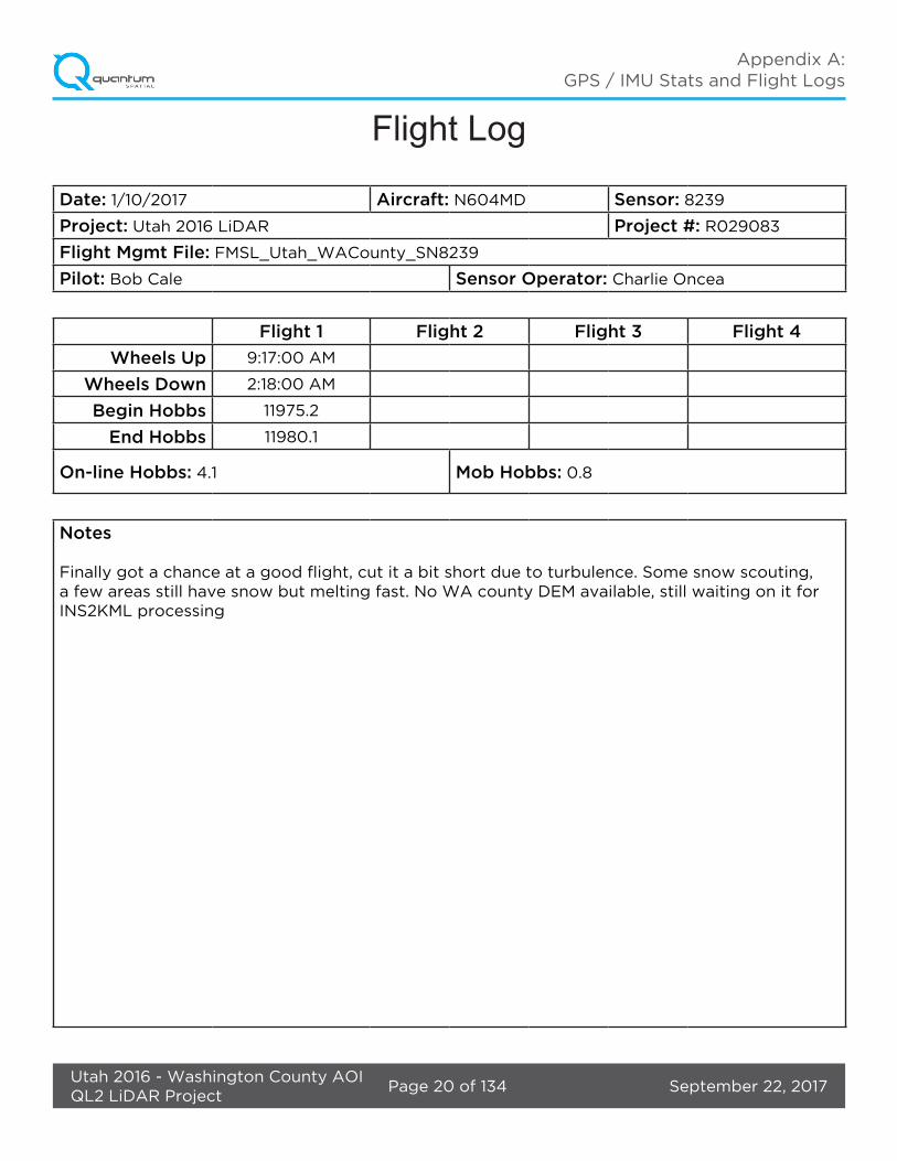
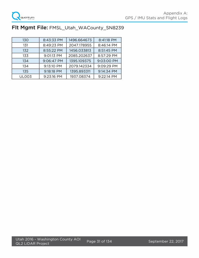
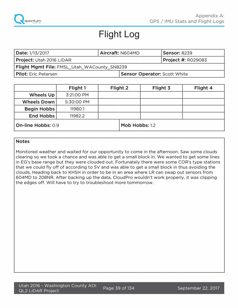
3.1. Flight Logs
Flight logs were completed by LIDAR sensor technicians for each mission during acquisition. These logs depict a variety of information, including:
• Job / Project #• Flight Date / Lift Number• FOV (Field of View) • Scan Rate (HZ) • Pulse Rate Frequency (Hz)• Ground Speed• Altitude• Base Station• PDOP avoidance times• Flight Line #• Flight Line Start and Stop Times• Flight Line Altitude (AMSL)• Heading• Speed• Returns• Crab
Notes: (Visibility, winds, ride, weather, temperature, dew point, pressure, etc). Project specific flight logs for each sortie are available in Appendix A.
3. Processing Summary

September 22, 2017Page 10 of 20Utah 2016 - Washington County AOIQL2 LiDAR Project
Project Report
3.2. LiDAR Processing
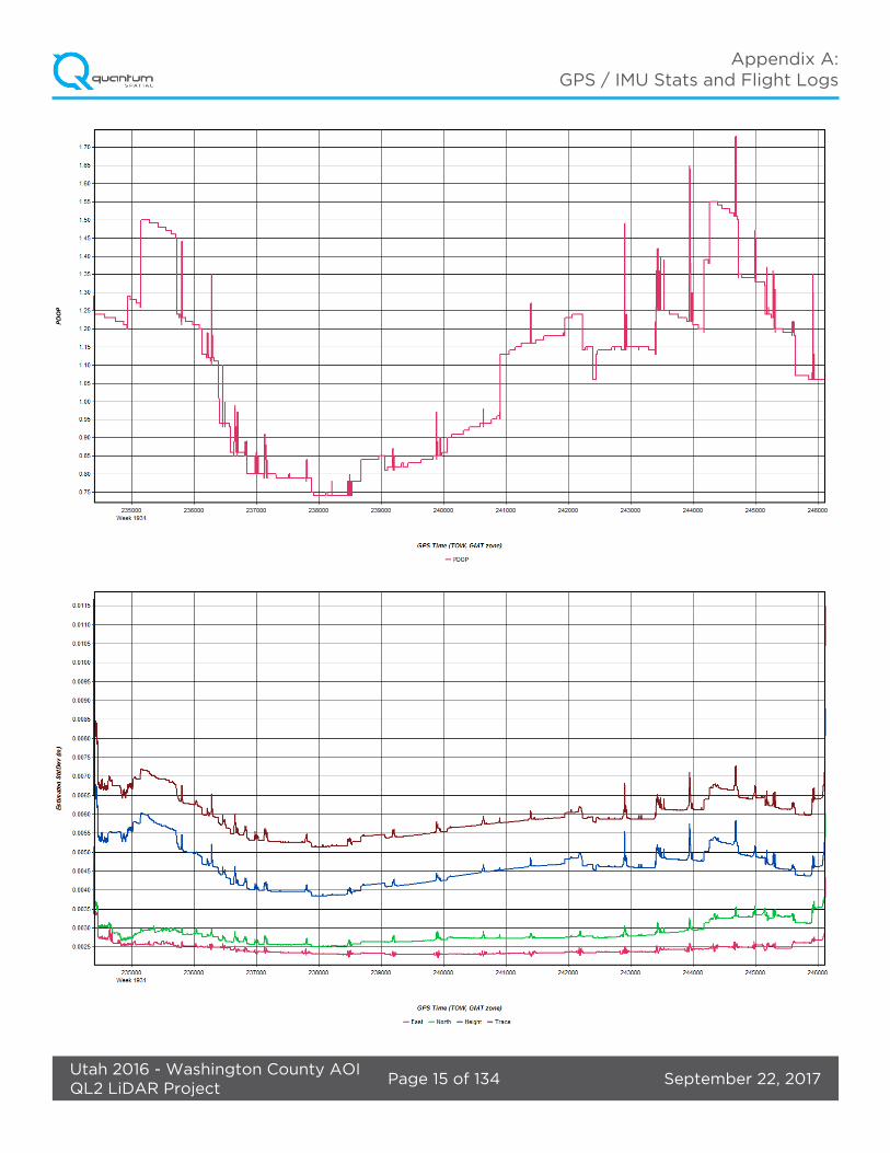
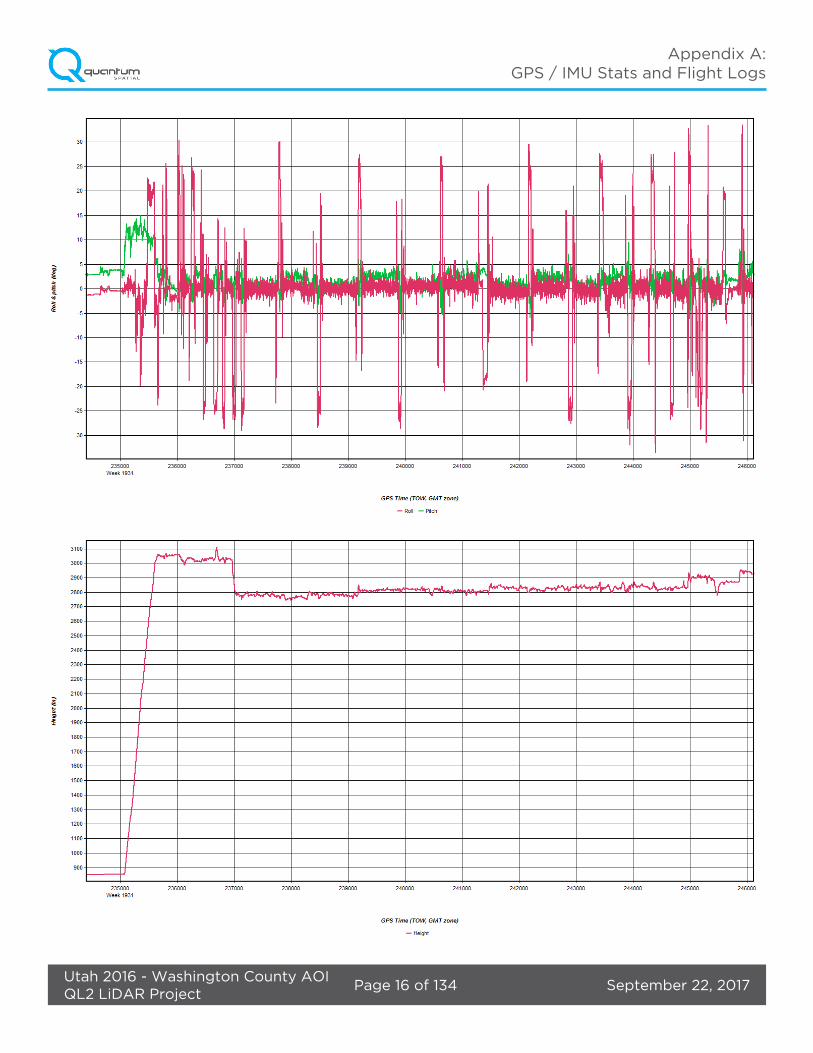
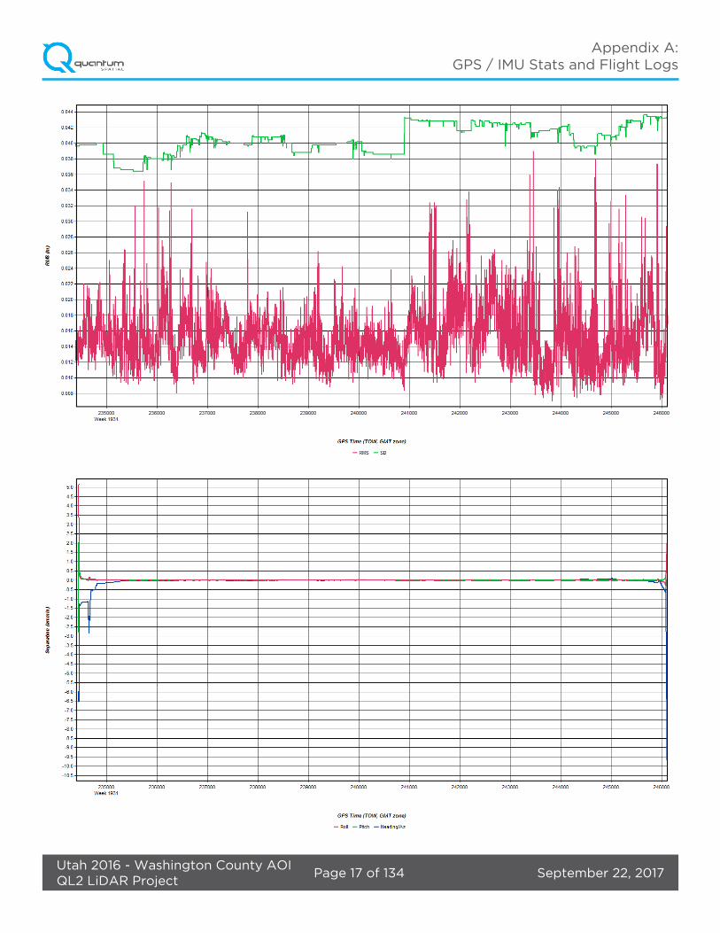
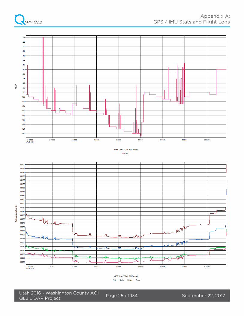
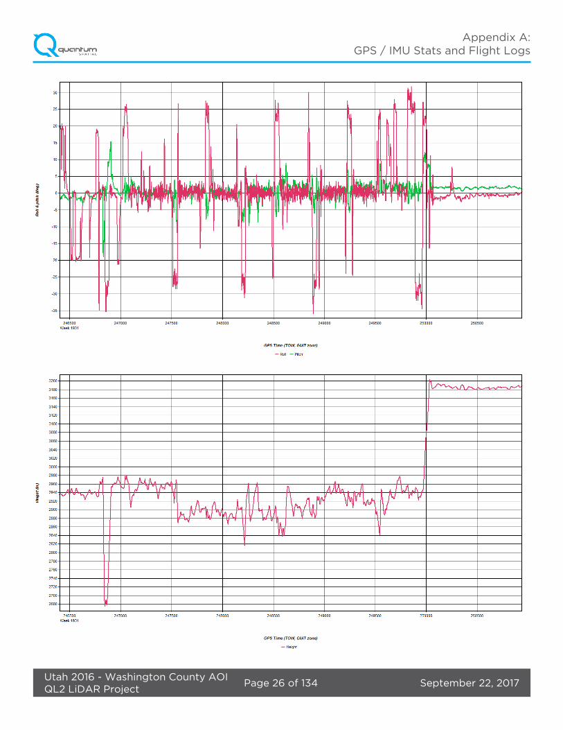
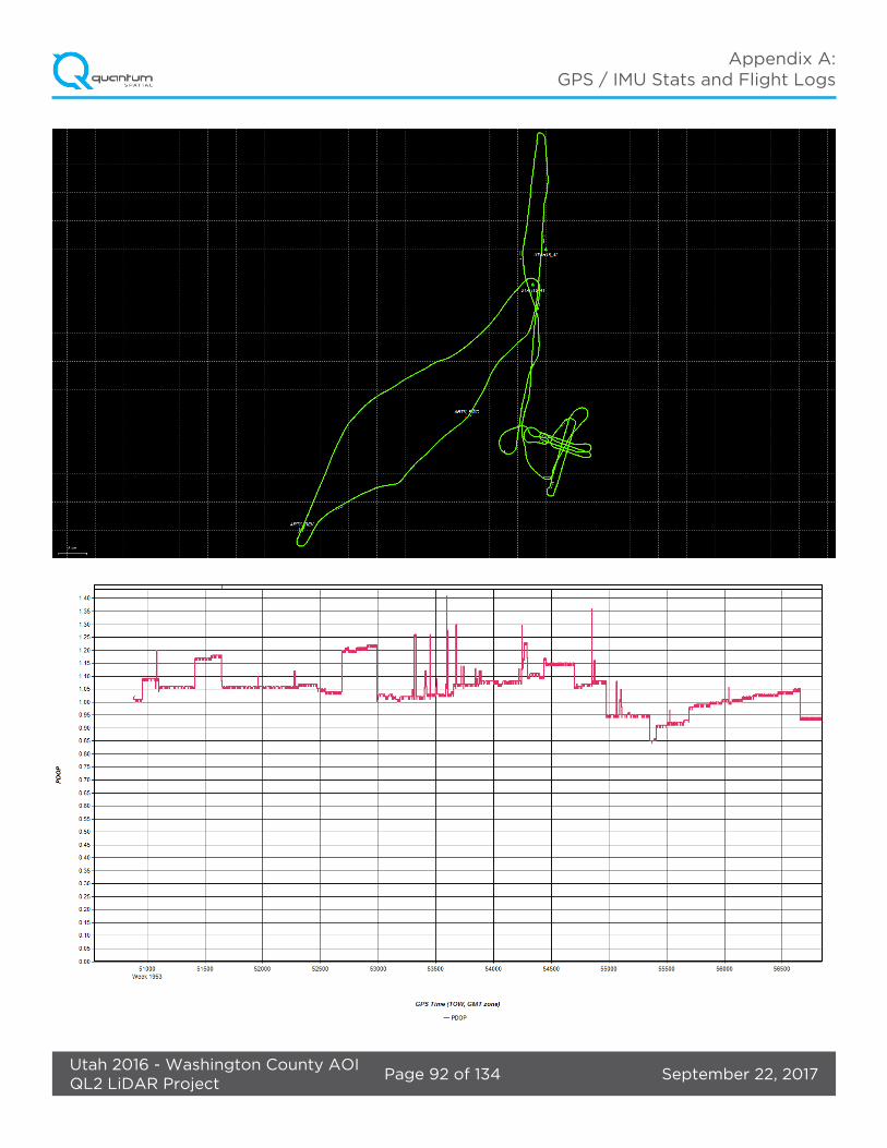
Inertial Explorer software was used for post-processing of airborne GPS and inertial data (IMU), which is critical to the positioning and orientation of the LiDAR sensor during all flights. Inertial Explorer combines aircraft raw trajectory data with stationary GPS base station data yielding a “Smoothed Best Estimate Trajectory (SBET) necessary for additional post processing software to develop the resulting geo-referenced point cloud from the LiDAR missions.
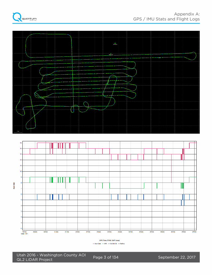
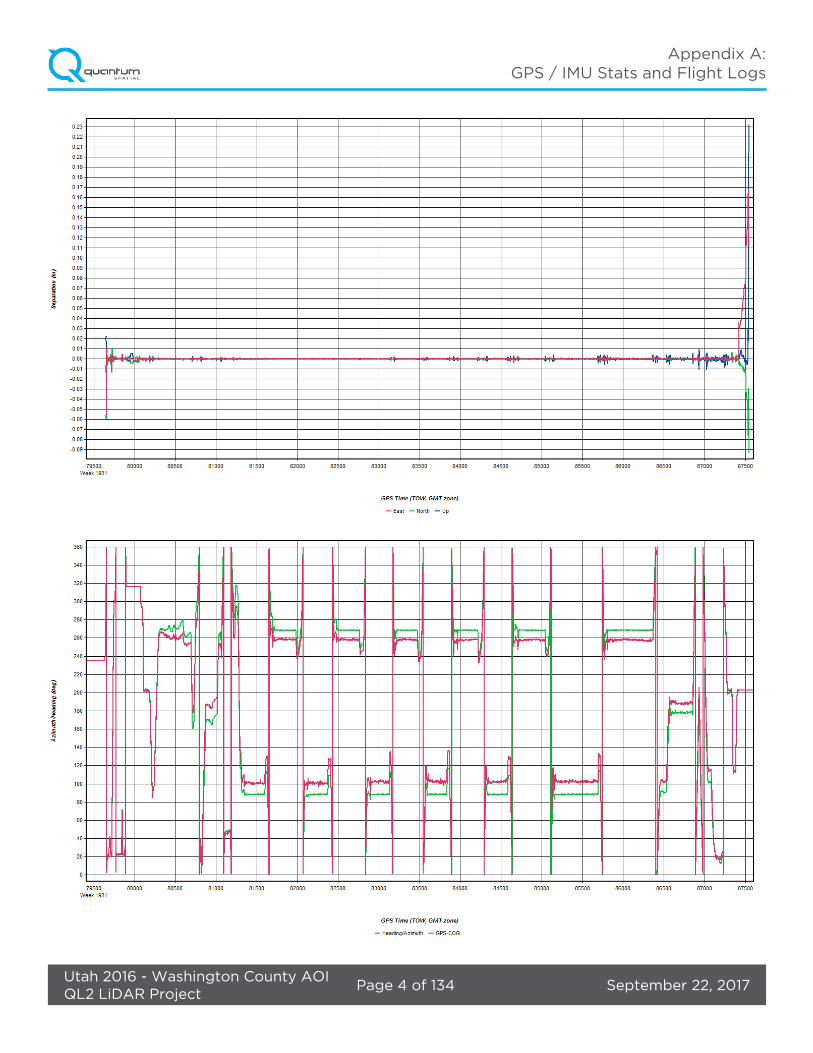
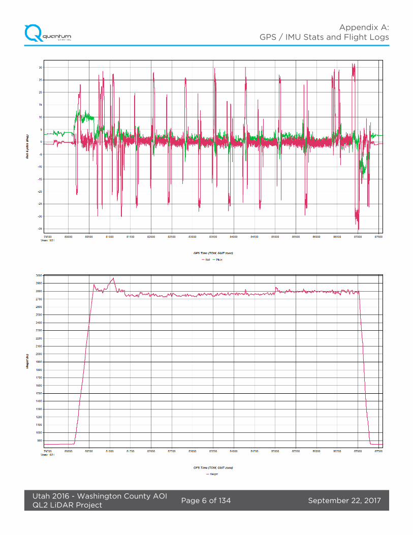
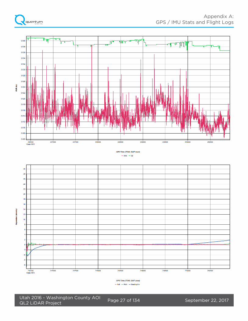
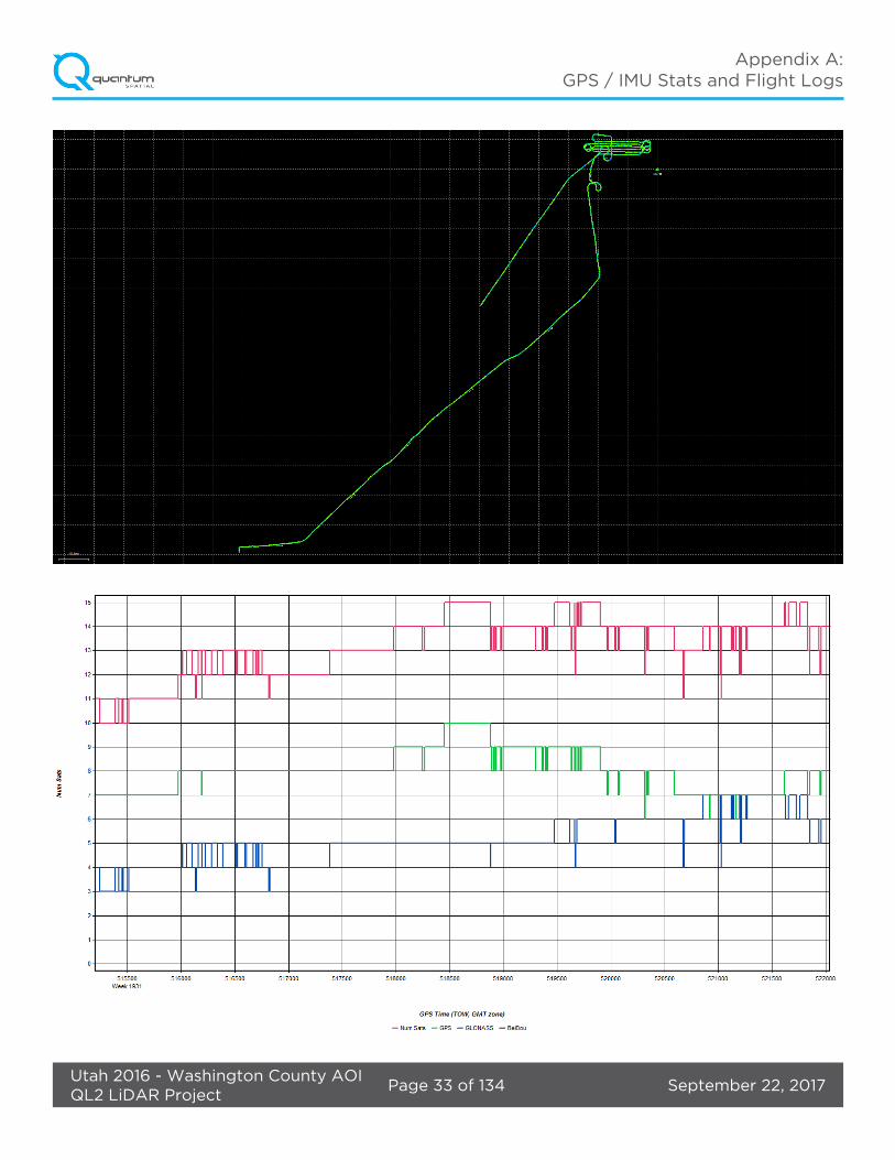
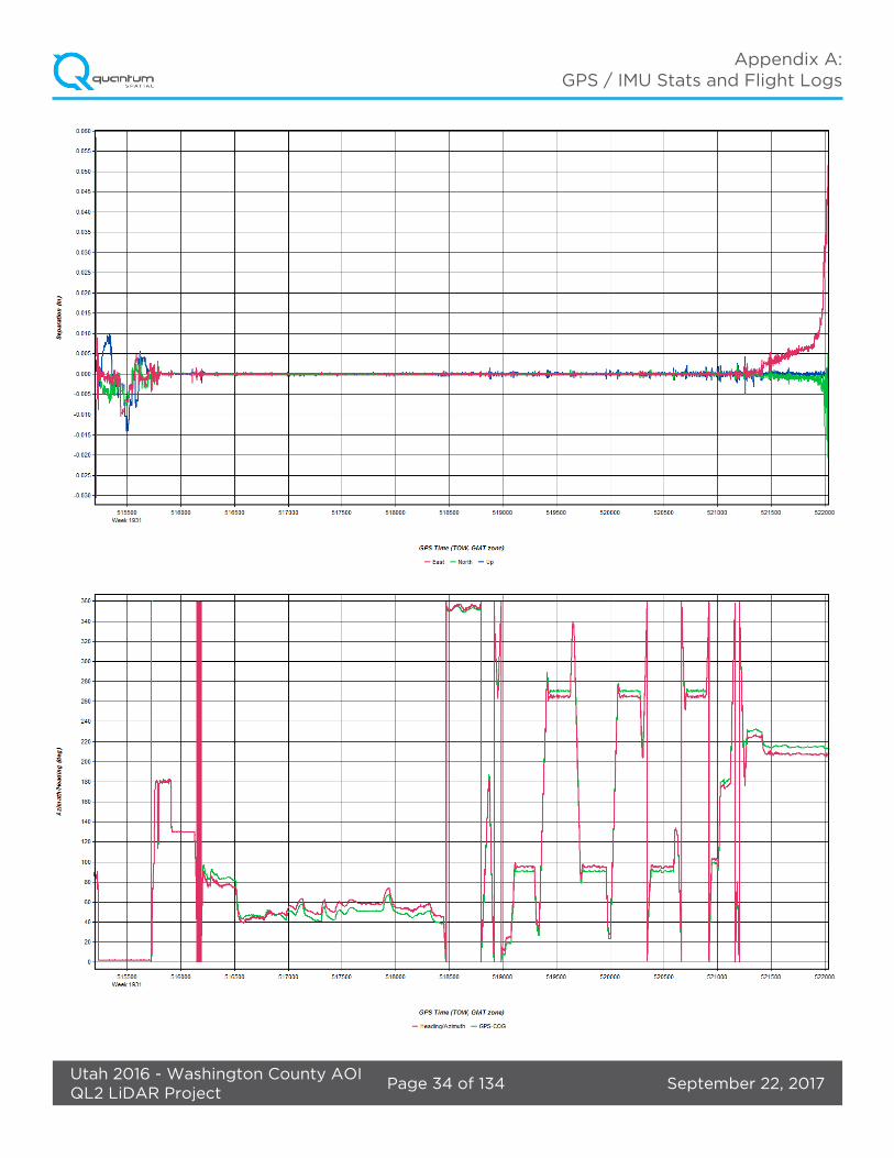
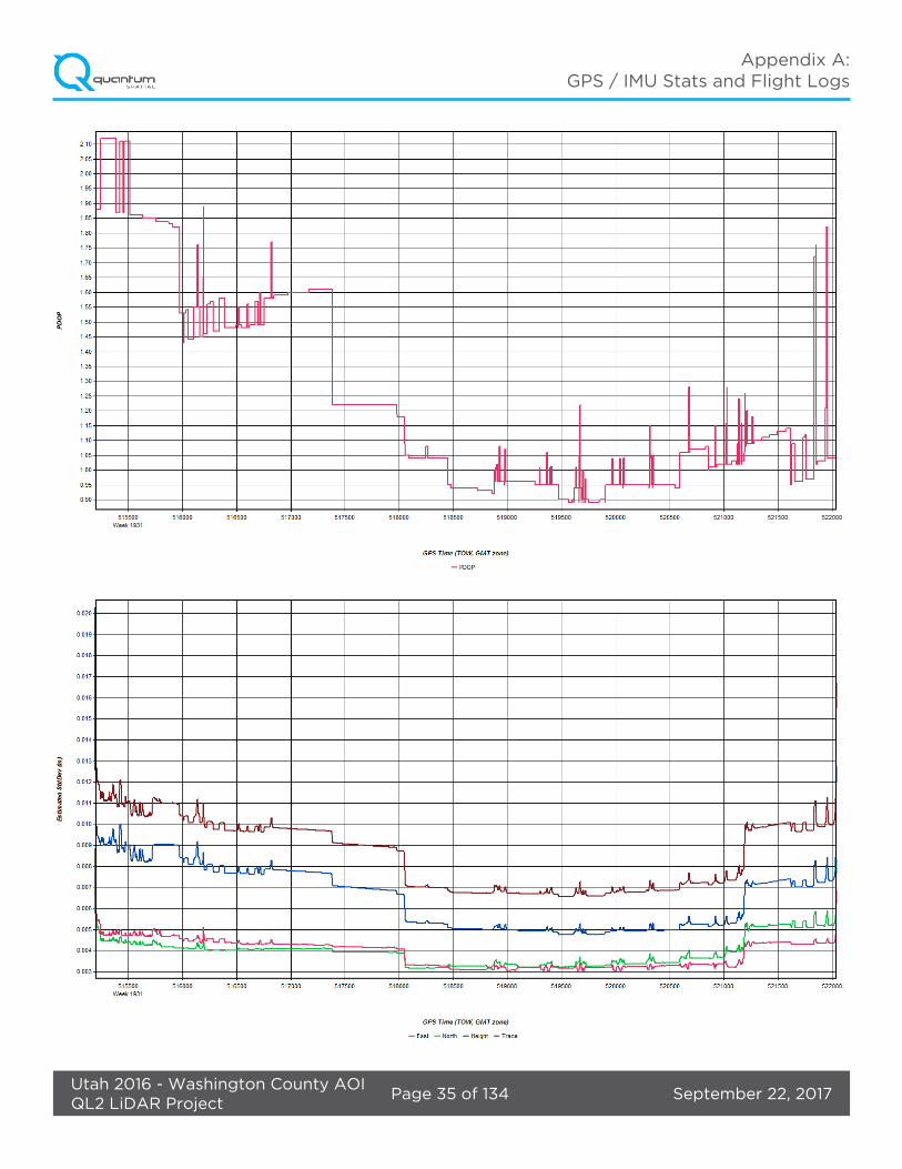
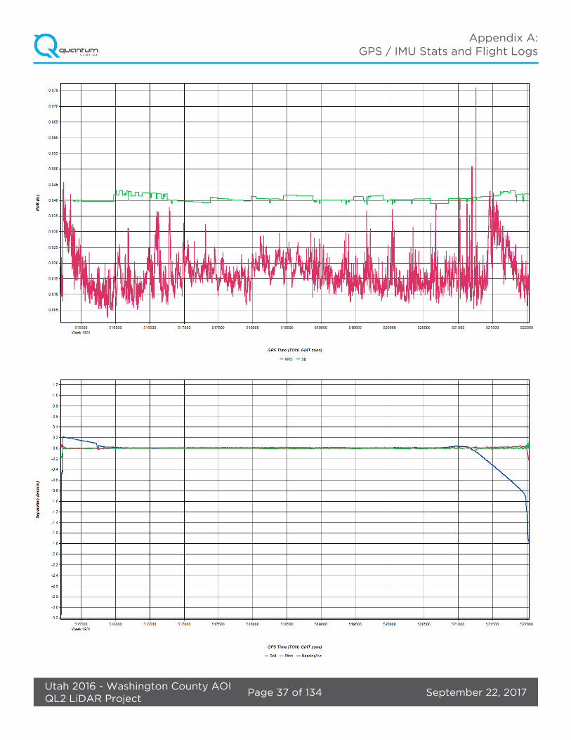
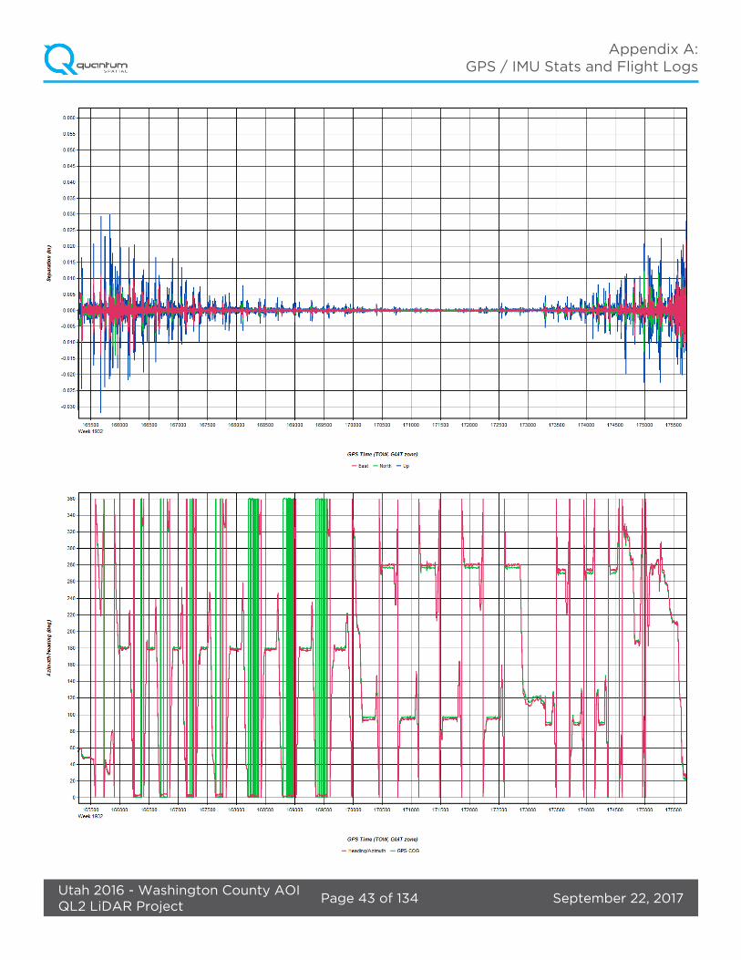
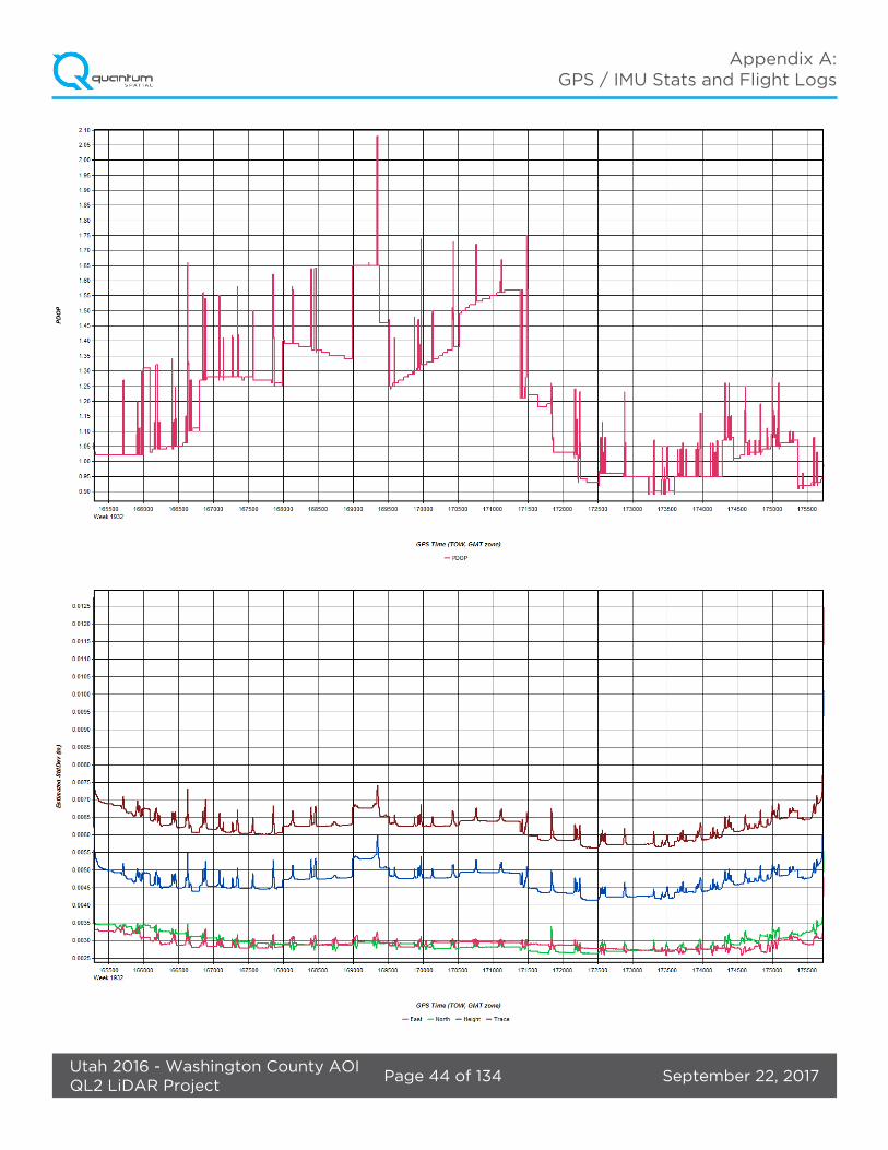
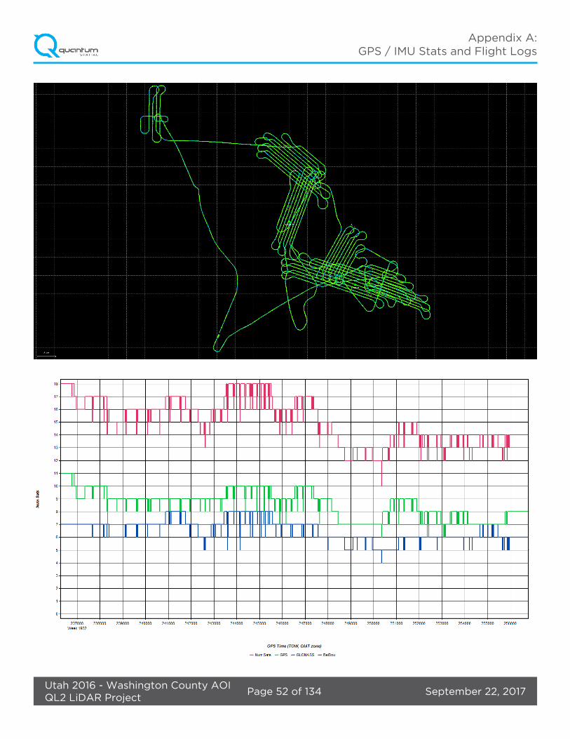
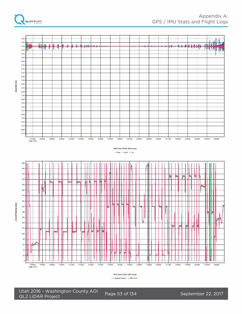
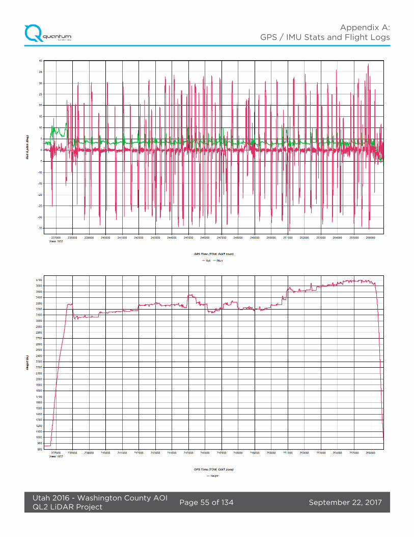
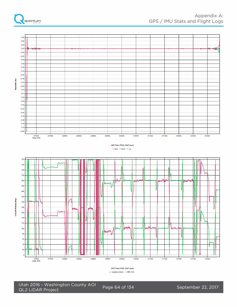
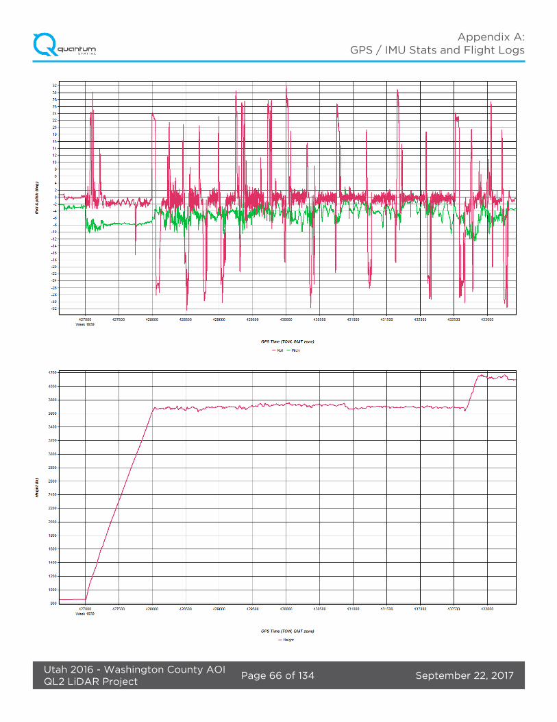
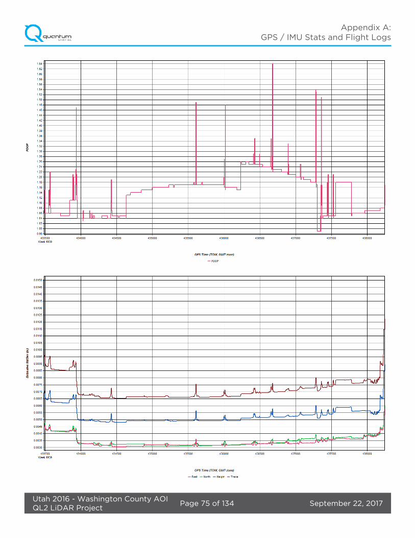
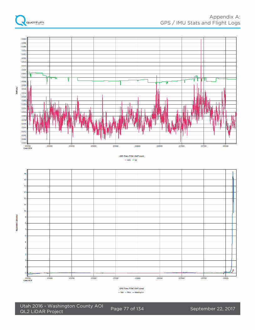
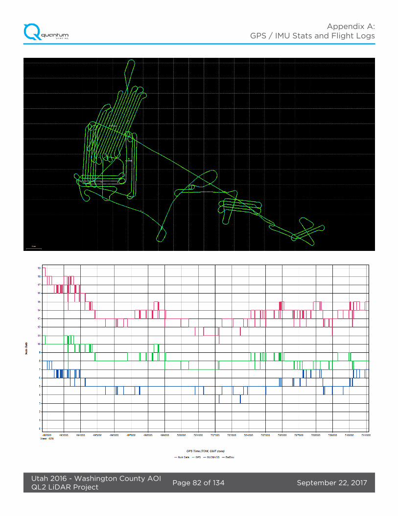
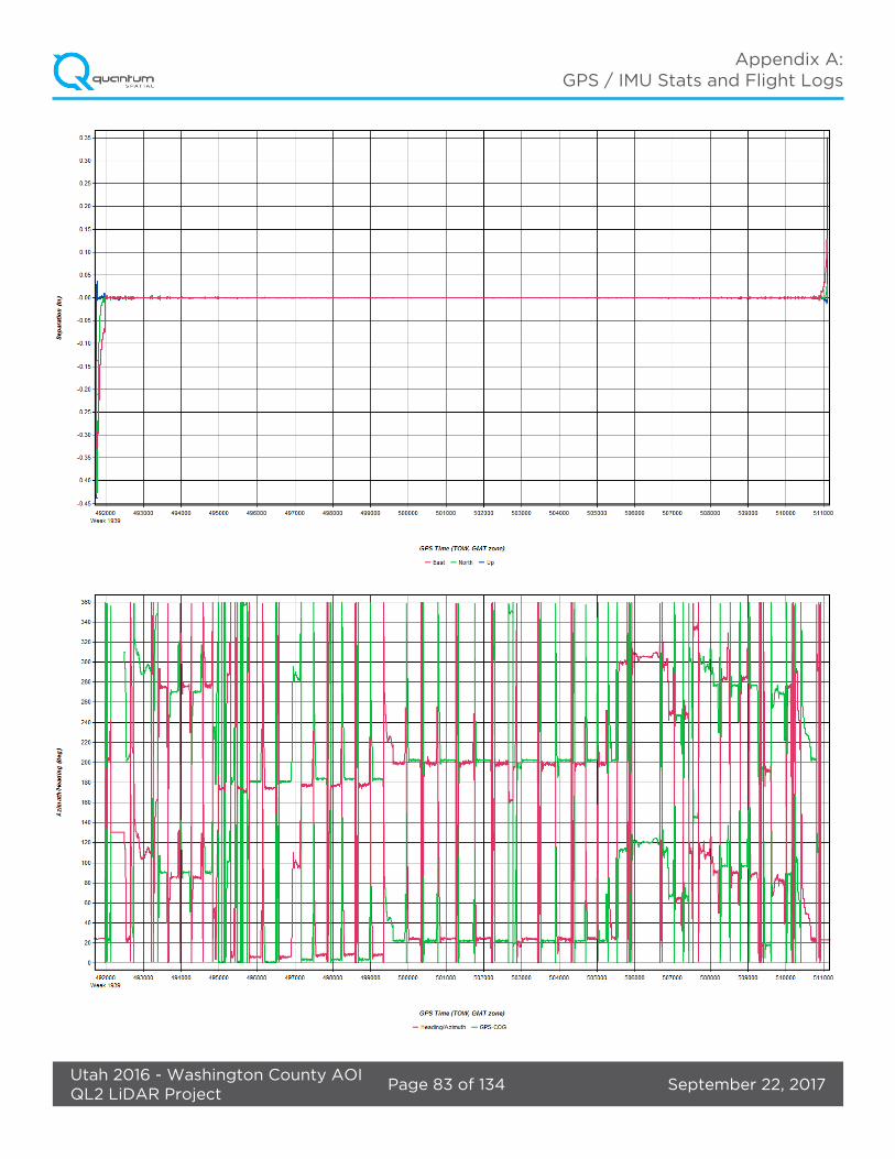
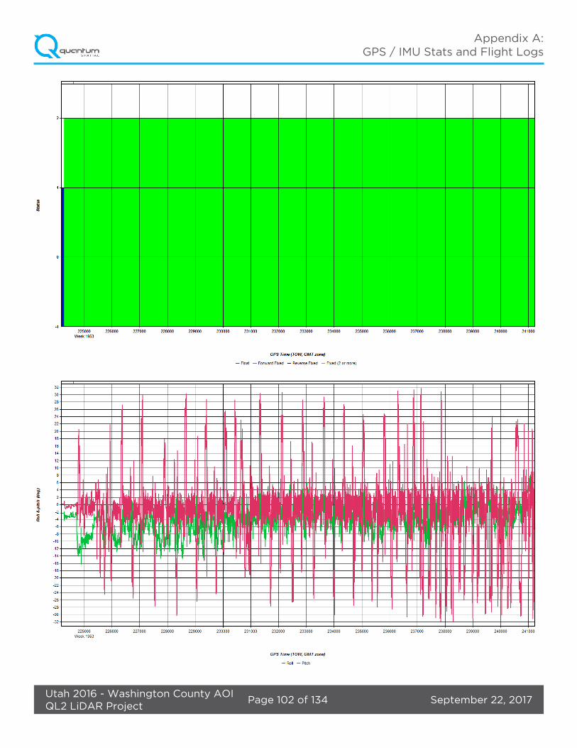
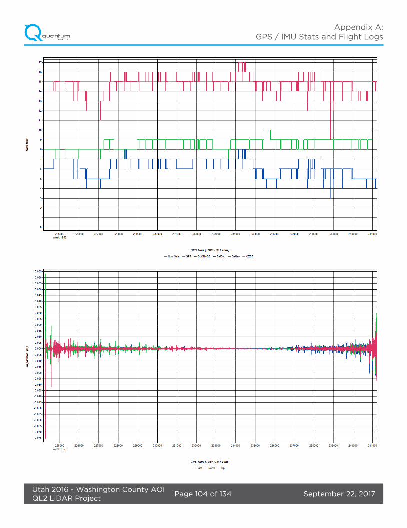
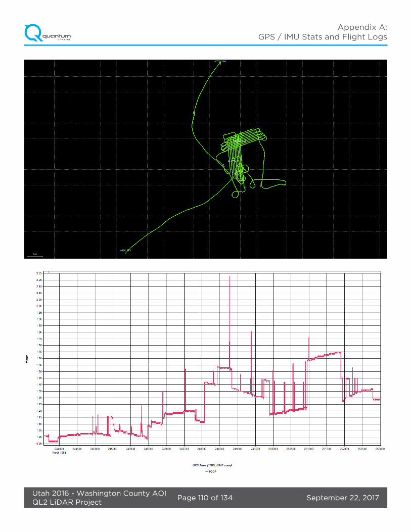
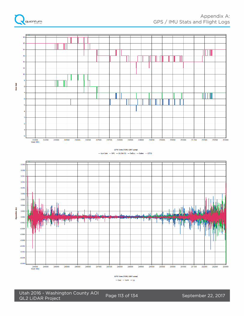
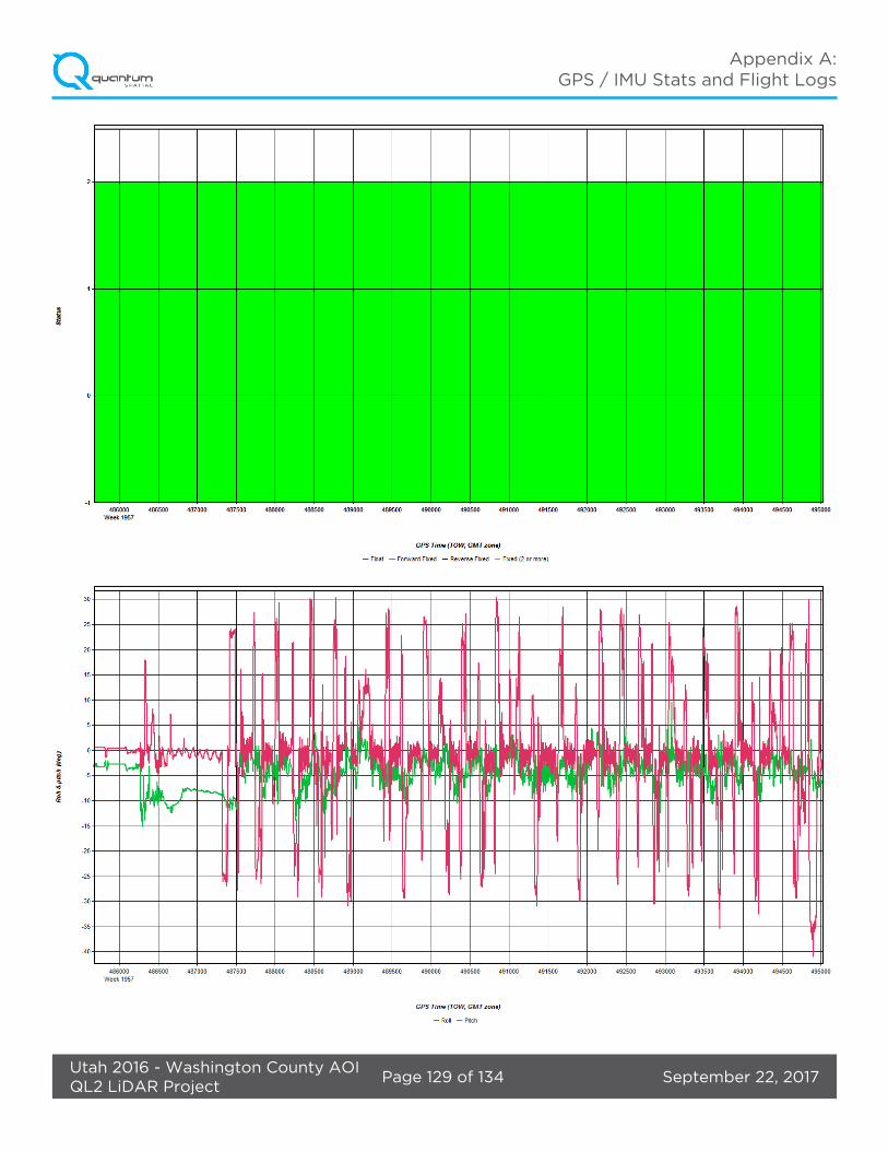
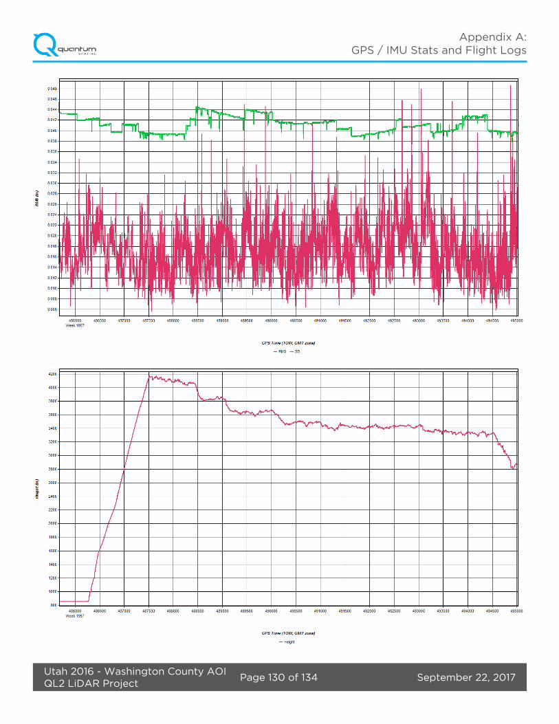
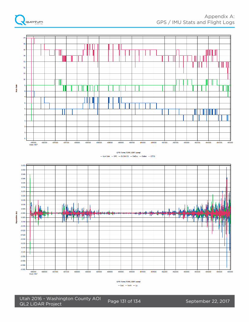
During the sensor trajectory processing (combining GPS & IMU datasets) certain statistical graphs and tables are generated within the Inertial Explorer processing environment which are commonly used as indicators of processing stability and accuracy. This data for analysis include: Max horizontal / vertical GPS variance, separation plot, altitude plot, PDOP plot, base station baseline length, processing mode, number of satellite vehicles, and mission trajectory. All relevant graphs produced in the Inertial Explorer processing environment for each sortie during the project mobilization will be available in the full report.
The generated point cloud is the mathematical three dimensional composite of all returns from all laser pulses as determined from the aerial mission. Laser point data are imported into TerraScan and a manual calibration is performed to assess the system offsets for pitch, roll, heading and scale. At this point this data is ready for analysis, classification, and filtering to generate a bare earth surface model in which the above-ground features are removed from the data set. Point clouds were created using the Leica CloudPro software. GeoCue distributive processing software was used in the creation of some files needed in downstream processing, as well as in the tiling of the dataset into more manageable file sizes. TerraScan and TerraModeler software packages were then used for the automated data classification, manual cleanup, and bare earth generation. Project specific macros were developed to classify the ground and remove side overlap between parallel flight lines.
All data was manually reviewed and any remaining artifacts removed using functionality provided by TerraScan and TerraModeler. Global Mapper was used as a final check of the bare earth dataset. GeoCue was used to create the deliverable industry-standard LAS files for both the All Point Cloud Data and the Bare Earth. In-house software was then used to perform final statistical analysis of the classes in the LAS files.
September 22, 2017Page 11 of 20Utah 2016 - Washington County AOIQL2 LiDAR Project
Project Report
3.3. LAS Classification Scheme
The classification classes are determined by the USGS Version 1.2 specifications and are an industry standard for the classification of LIDAR point clouds. All data starts the process as Class 1 (Unclassified), and then through automated classification routines, the classifications are determined using TerraScan macro processing.
The classes used in the dataset are as follows and have the following descriptions:
• Class 1 – Processed, but Unclassified – These points would be the catch all for points that do not fit any of the other deliverable classes. This would cover features such as vegetation, cars, etc.
• Class 2 – Bare-Earth Ground – This is the bare earth surface• Class 7 – Low Noise – Low points, manually identified below the surface that could be noise
points in point cloud.• Class 9 – In-land Water – Points found inside of inland lake/ponds• Class 10 – Ignored Ground – Points found to be close to breakline features. Points are moved
to this class from the Class 2 dataset. This class is ignored during the DEM creation process in order to provide smooth transition between the ground surface and hydro flattened surface.
• Class 17 – Bridge Decks – Points falling on bridge decks.• Class 18 – High Noise – High points, manually identified above the surface that could be
noise points in point cloud.
3.4. Classified LAS Processing
The point classification is performed as described below. The bare earth surface is then manually reviewed to ensure correct classification on the Class 2 (Ground) points. After the bare-earth surface is finalized, it is then used to generate all hydro-breaklines through heads-up digitization.
All ground (ASPRS Class 2) lidar data inside of the Lake Pond and Double Line Drain hydroflattened breaklines were then classified to Water (ASPRS Class 9) using TerraScan macro functionality. A buffer of 1 meter was also used around each hydro-flattened feature to classify these ground (ASPRS Class 2) points to Ignored ground (ASPRS Class 10). All Lake Pond Island and Double Line Drain Island features were checked to ensure that the ground (ASPRS Class 2) points were reclassified to the correct classification after the automated classification was completed. All bridge decks were classified to Class 17.
All overlap data was processed through automated functionality provided by TerraScan to classify the overlapping flight line data to approved classes by USGS. The overlap data was classified using standard LAS overlap bit. These classes were created through automated processes only and were not verified for classification accuracy. Due to software limitations within TerraScan, these classes were used to trip the withheld bit within various software packages. These processes were reviewed and accepted by USGS through numerous conference calls and pilot study areas.
All data was manually reviewed and any remaining artifacts removed using functionality
September 22, 2017Page 12 of 20Utah 2016 - Washington County AOIQL2 LiDAR Project
Project Report
provided by TerraScan and TerraModeler. Global Mapper us used as a final check of the bare earth dataset. GeoCue was then used to create the deliverable industry-standard LAS files for both the All Point Cloud Data and the Bare Earth. Quantum Spatial, Inc. proprietary software was used to perform final statistical analysis of the classes in the LAS files, on a per tile level to verify final classification metrics and full LAS header information.
3.5. Hydro-Flattened Breakline Processing
Class 2 (ground) lidar points was used to create a bare earth surface model. The surface model was then used to heads-up digitize 2D breaklines of inland streams and rivers with a 100-foot nominal width and inland ponds and lakes of 2 acres or greater surface area.
Elevation values were assigned to all Inland Ponds and Lakes, Inland Pond and Lake Islands, Inland Stream and River Islands, using TerraModeler functionality. Elevation values were assigned to all inland streams and rivers using Quantum Spatial, Inc. proprietary software. All Ground (ASPRS Class 2) lidar data inside of the collected inland breaklines were then classified to Water (ASPRS Class 9) using TerraScan macro functionality. A buffer of 1 meter was also used around each hydro-flattened feature. These points were moved from ground (ASPRS Class 2) to Ignored Ground (ASPRS Class 10).
The breakline files were then translated to Esri file geodatabase format using Esri conversion tools.
Breaklines are reviewed against lidar intensity imagery to verify completeness of capture. All breaklines are then compared to TINs (triangular irregular networks) created from ground only points prior to water classification. The horizontal placement of breaklines is compared to terrain features and the breakline elevations are compared to lidar elevations to ensure all breaklines match the lidar within acceptable tolerances. Some deviation is expected between breakline and lidar elevations due to monotonicity, connectivity, and flattening rules that are enforced on the breaklines. Once completeness, horizontal placement, and vertical variance is reviewed, all breaklines are reviewed for topological consistency and data integrity using a combination of Esri Data Reviewer tools and proprietary tools.
3.6. Hydro-Flattened Raster DEM Processing
Class 2 LiDAR in conjunction with the hydro breaklines were used to create a 0.5-meter hydro-flattened raster DEM. Using automated scripting routines within ArcMap, an ERDAS Imagine .IMG file was created for each tile. Each surface is reviewed using Global Mapper to check for any surface anomalies or incorrect elevations found within the surface.
3.7. First Return Raster DSM Processing
First return lidar points were used to create a 0.5 meter first-return raster DSM. Using automated scripting routines within ArcMap, an ERDAS Imagine .IMG file was created for each tile. Each surface is reviewed using Global Mapper to check for any surface anomalies or incorrect elevations found within the surface.
September 22, 2017Page 13 of 20Utah 2016 - Washington County AOIQL2 LiDAR Project
Project Report
3.8. Intensity Image Processing
GeoCue software was used to create the deliverable Intensity Images. All overlap classes were ignored during this process. This helps to ensure a more aesthetically pleasing image. The GeoCue software was then used to verify full project coverage as well. TIF/TWF files were then provided as the deliverable for this dataset requirement.

September 22, 2017Page 14 of 20Utah 2016 - Washington County AOIQL2 LiDAR Project
Project Report
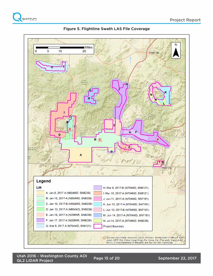
Coverage verification was performed by comparing coverage of processed .LAS files captured during project collection to generate project shape files depicting boundaries of specified project areas. Please refer to Figure 5.
4. Project Coverage Verification
September 22, 2017Page 15 of 20Utah 2016 - Washington County AOIQL2 LiDAR Project
Project Report
Figure 5. Flightline Swath LAS File Coverage
September 22, 2017Page 16 of 20Utah 2016 - Washington County AOIQL2 LiDAR Project
Project Report
Quantum Spatial completed a field survey of 144 ground control (calibration) points along with 59 blind QA points in Vegetated and Non-Vegetated land cover classifications (total of 203 points) as an independent test of the accuracy of this project.
A combination of precise GPS surveying methods, including static and RTK observations were used to establish the 3D position of ground calibration points and QA points for the point classes above. GPS was not an appropriate methodology for surveying in the forested areas during the leaf-on conditions for the actual field survey (which was accomplished after the LiDAR acquisition). Therefore the 3D positions for the forested points were acquired using a GPS-derived offset point located out in the open near the forested area, and using precise offset surveying techniques to derive the 3D position of the forested point from the open control point. The explicit goal for these surveys was to develop 3D positions that were three times greater than the accuracy requirement for the elevation surface. In this case of the blind QA points the goal was a positional accuracy of 5 cm in terms of the RMSE.
The required accuracy testing was performed on the LiDAR dataset (both the LiDAR point cloud and derived DEM’s) according to the USGS LiDAR Base Specification Version 1.2 (2014). In this document, horizontal coordinates for ground control and QA points for all LiDAR classes are reported in NAD83 (2011) UTM Zone 12, meters; NAVD88 (GEOID12B), meters.
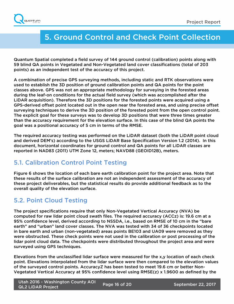
5.1. Calibration Control Point Testing
Figure 6 shows the location of each bare earth calibration point for the project area. Note that these results of the surface calibration are not an independent assessment of the accuracy of these project deliverables, but the statistical results do provide additional feedback as to the overall quality of the elevation surface.
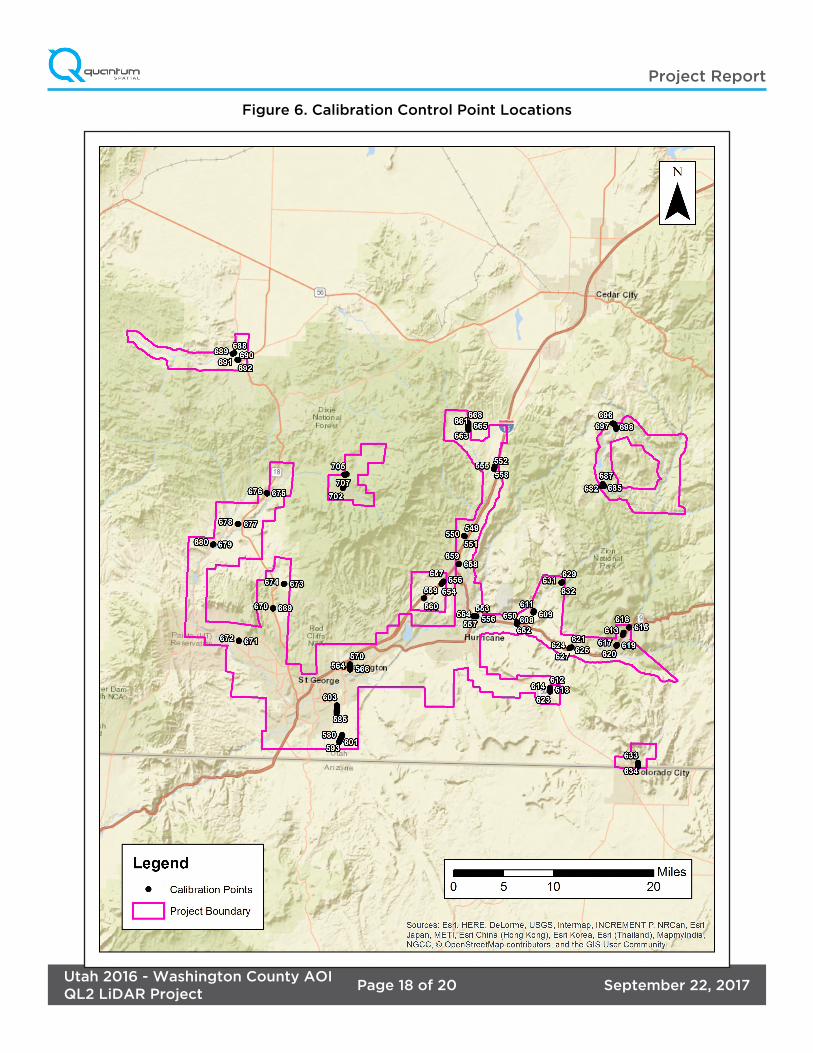
5.2. Point Cloud Testing
The project specifications require that only Non-Vegetated Vertical Accuracy (NVA) be computed for raw lidar point cloud swath files. The required accuracy (ACCz) is: 19.6 cm at a 95% confidence level, derived according to NSSDA, i.e., based on RMSE of 10 cm in the “bare earth” and “urban” land cover classes. The NVA was tested with 34 of 36 checkpoints located in bare earth and urban (non-vegetated) areas points BE103 and UA09 were removed as they were obstructed. These check points were not used in the calibration or post processing of the lidar point cloud data. The checkpoints were distributed throughout the project area and were surveyed using GPS techniques.
Elevations from the unclassified lidar surface were measured for the x,y location of each check point. Elevations interpolated from the lidar surface were then compared to the elevation values of the surveyed control points. AccuracyZ has been tested to meet 19.6 cm or better Non-Vegetated Vertical Accuracy at 95% confidence level using RMSE(z) x 1.9600 as defined by the
5. Ground Control and Check Point Collection

September 22, 2017Page 17 of 20Utah 2016 - Washington County AOIQL2 LiDAR Project
Project Report
National Standards for Spatial Data Accuracy (NSSDA); assessed and reported using National Digital Elevation Program (NDEP)/ASRPS Guidelines. See Figure 7.
5.3. Digital Elevation Model (DEM) Testing
The project specifications require the accuracy (ACCz) of the derived DEM be calculated and reported in two ways:
1. The required NVA is: 19.6 cm at a 95% confidence level, derived according to NSSDA, i.e., based on RMSE of 10 cm in the “bare earth” and “urban” land cover classes. This is a required accuracy. The NVA was tested with 34 of 36 checkpoints located in bare earth and urban (non-vegetated) areas points; BE103 and UA09 were removed as they were obstructed. See Figure 7.
2. Vegetated Vertical Accuracy (VVA): VVA shall be reported for “forested”, “brushlands/low trees” and “tall weeds/crops” land cover classes. The target VVA is: 29.4 cm at the 95th percentile, derived according to ASPRS Guidelines, Vertical Accuracy Reporting for Lidar Data, i.e., based on the 95th percentile error in all vegetated land cover classes combined. This is a target accuracy. The VVA was tested with 25 checkpoints located in forested, tall weeds/crops and brushlands/low trees (vegetated) areas. The checkpoints were distributed throughout the project area and were surveyed using GPS techniques. See Figure 8.
AccuracyZ has been tested to meet 19.6 cm or better Non-Vegetated Vertical Accuracy at 95% confidence level using RMSE(z) x 1.9600 as defined by the National Standards for Spatial Data Accuracy (NSSDA); assessed and reported using National Digital Elevation Program (NDEP)/ASRPS Guidelines.
For more information, see the FOCUS on Accuracy report.
Accuracy Test Target Measured Points Used
Raw NVA 0.196 m 0.0911 m 34
NVA 0.196 m 0.0896 m 34
VVA 0.294m 0.1389 m 25
September 22, 2017Page 18 of 20Utah 2016 - Washington County AOIQL2 LiDAR Project
Project Report
Figure 6. Calibration Control Point Locations
September 22, 2017Page 19 of 20Utah 2016 - Washington County AOIQL2 LiDAR Project
Project Report
Figure 7. QC Checkpoint Locations - NVA

September 22, 2017Page 20 of 20Utah 2016 - Washington County AOIQL2 LiDAR Project
Project Report
Figure 8. QC Checkpoint Locations - VVA

September 22, 2017Utah 2016 - Washington County AOIQL2 LiDAR Project
Appendices
The following section contains the appendices as listed in
the Utah 2016 - Washington County AOI Project Report.
Project Report Appendices

September 22, 2017Utah 2016 - Washington County AOIQL2 LiDAR Project
Appendices
GPS/IMU Statistics
Flight Logs
Appendix A

September 22, 2017Page 1 of 134Utah 2016 - Washington County AOIQL2 LiDAR Project
Appendix A: GPS / IMU Stats and Flight Logs
Jan 8, 2017-A (N604MD, SN8239) �����������������������������������������������������������������������������������������������������2Flight Log ����������������������������������������������������������������������������������������������������������������������������������������10
Jan 10, 2017-A (N604MD, SN8239)�������������������������������������������������������������������������������������������������� 12Flight Log ���������������������������������������������������������������������������������������������������������������������������������������20
Jan 10, 2017-B (N604MD, SN8239) ������������������������������������������������������������������������������������������������� 22Flight Log ���������������������������������������������������������������������������������������������������������������������������������������30
Jan 13, 2017-A (N604MD, SN8239) ������������������������������������������������������������������������������������������������� 32Flight Log ��������������������������������������������������������������������������������������������������������������������������������������� 39
Jan 16, 2017-A (N208NR, SN8239) ���������������������������������������������������������������������������������������������������41Flight Log ���������������������������������������������������������������������������������������������������������������������������������������49
Jan 17, 2017-A (N208NR, SN8239) ��������������������������������������������������������������������������������������������������� 51Flight Log ��������������������������������������������������������������������������������������������������������������������������������������� 59
Mar 9, 2017-A (N704MD, SN8121) ���������������������������������������������������������������������������������������������������� 62Flight Log ���������������������������������������������������������������������������������������������������������������������������������������70
Mar 9, 2017-B (N704MD, SN8121) ���������������������������������������������������������������������������������������������������� 72Flight Log ��������������������������������������������������������������������������������������������������������������������������������������� 79
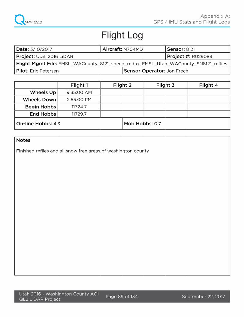
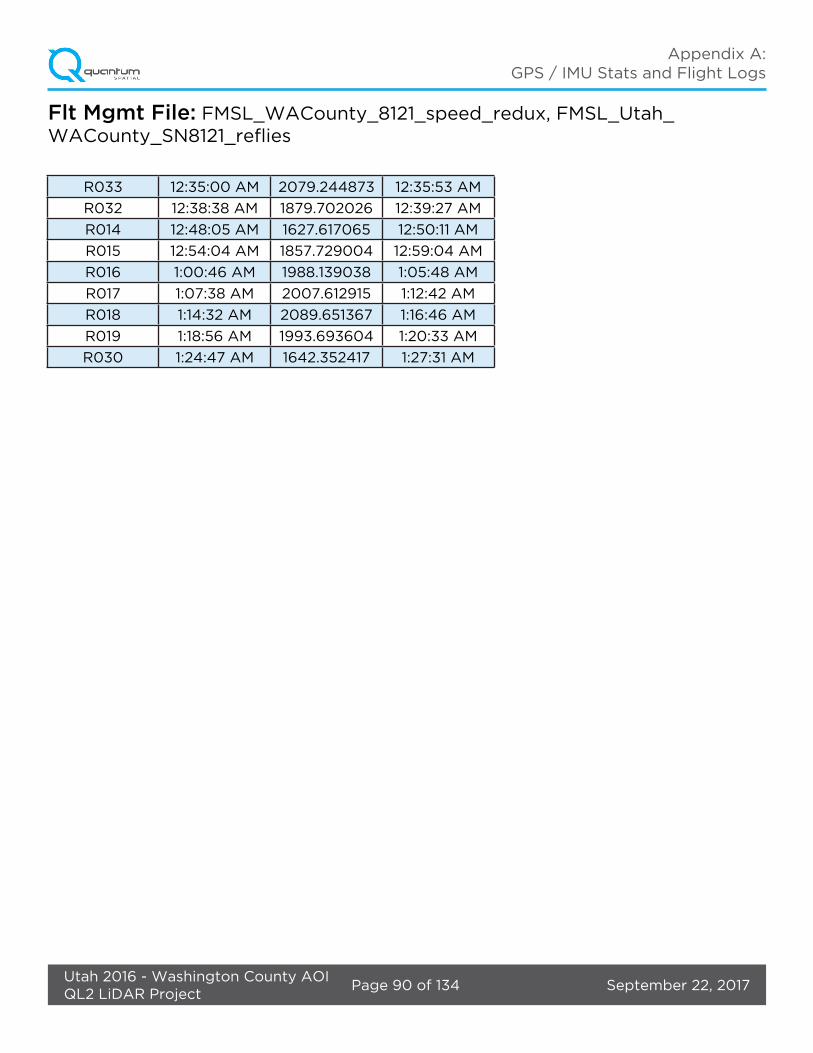
Mar 10, 2017-A (N704MD, SN8121) ���������������������������������������������������������������������������������������������������81Flight Log ��������������������������������������������������������������������������������������������������������������������������������������� 89
Jun 11, 2017-A (N704MD, SN7161) ����������������������������������������������������������������������������������������������������91Flight Log ���������������������������������������������������������������������������������������������������������������������������������������99
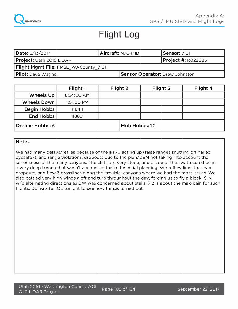
Jun 13, 2017-A (N704MD, SN7161) ������������������������������������������������������������������������������������������������� 100Flight Log ������������������������������������������������������������������������������������������������������������������������������������� 108
Jun 13, 2017-B (N704MD, SN7161) ������������������������������������������������������������������������������������������������� 109Flight Log ���������������������������������������������������������������������������������������������������������������������������������������117
Jun 14, 2017-A (N704MD, SN7161) ��������������������������������������������������������������������������������������������������118Flight Log ��������������������������������������������������������������������������������������������������������������������������������������126
Jul 14, 2017-A (N704MD, SN8239) �������������������������������������������������������������������������������������������������127Flight Log ��������������������������������������������������������������������������������������������������������������������������������������134
There were 14 total lifts. Graph reports generated from processing software and flight logs are found on the following pages.
September 22, 2017Page 2 of 134Utah 2016 - Washington County AOIQL2 LiDAR Project
Appendix A: GPS / IMU Stats and Flight Logs
Jan 8, 2017-A (N604MD, SN8239)
September 22, 2017Page 3 of 134Utah 2016 - Washington County AOIQL2 LiDAR Project
Appendix A: GPS / IMU Stats and Flight Logs
September 22, 2017Page 4 of 134Utah 2016 - Washington County AOIQL2 LiDAR Project
Appendix A: GPS / IMU Stats and Flight Logs

September 22, 2017Page 5 of 134Utah 2016 - Washington County AOIQL2 LiDAR Project
Appendix A: GPS / IMU Stats and Flight Logs
September 22, 2017Page 6 of 134Utah 2016 - Washington County AOIQL2 LiDAR Project
Appendix A: GPS / IMU Stats and Flight Logs

September 22, 2017Page 7 of 134Utah 2016 - Washington County AOIQL2 LiDAR Project
Appendix A: GPS / IMU Stats and Flight Logs
September 22, 2017Page 8 of 134Utah 2016 - Washington County AOIQL2 LiDAR Project
Appendix A: GPS / IMU Stats and Flight Logs

September 22, 2017Page 9 of 134Utah 2016 - Washington County AOIQL2 LiDAR Project
Appendix A: GPS / IMU Stats and Flight Logs

September 22, 2017Page 10 of 134Utah 2016 - Washington County AOIQL2 LiDAR Project
Appendix A: GPS / IMU Stats and Flight Logs
Flight Log
Date: 11/20/2016 Aircraft: Sensor:
Project: Utah 2016 LiDAR Project #: R029083
Flight Mgmt File: FMSL_Utah_WACounty_SN8239
Pilot: Bob Cale Sensor Operator: Charlie Oncea
Flight 1 Flight 2 Flight 3 Flight 4
Wheels Up 3:14:00 PM
Wheels Down 5:19:00 PM
Begin Hobbs 11972.8
End Hobbs 11974.8
On-line Hobbs: 1.8 Mob Hobbs: 0.2
Notes
Went to the airport early and waited all day for the clouds to lift. they stayed just below the project height until late in the day, and we got a chance for a short evening flight.
September 22, 2017Page 11 of 134Utah 2016 - Washington County AOIQL2 LiDAR Project
Appendix A: GPS / IMU Stats and Flight Logs
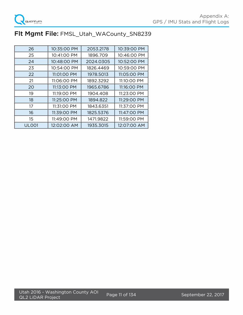
Flt Mgmt File: FMSL_Utah_WACounty_SN8239
26 10:35:00 PM 2053.2178 10:39:00 PM
25 10:41:00 PM 1896.709 10:46:00 PM
24 10:48:00 PM 2024.0305 10:52:00 PM
23 10:54:00 PM 1826.4469 10:59:00 PM
22 11:01:00 PM 1978.5013 11:05:00 PM
21 11:06:00 PM 1892.3292 11:10:00 PM
20 11:13:00 PM 1965.6786 11:16:00 PM
19 11:19:00 PM 1904.408 11:23:00 PM
18 11:25:00 PM 1894.822 11:29:00 PM
17 11:31:00 PM 1843.6351 11:37:00 PM
16 11:39:00 PM 1825.5376 11:47:00 PM
15 11:49:00 PM 1471.9822 11:59:00 PM
UL001 12:02:00 AM 1935.3015 12:07:00 AM

September 22, 2017Page 12 of 134Utah 2016 - Washington County AOIQL2 LiDAR Project
Appendix A: GPS / IMU Stats and Flight Logs
Jan 10, 2017-A (N604MD, SN8239)

September 22, 2017Page 13 of 134Utah 2016 - Washington County AOIQL2 LiDAR Project
Appendix A: GPS / IMU Stats and Flight Logs

September 22, 2017Page 14 of 134Utah 2016 - Washington County AOIQL2 LiDAR Project
Appendix A: GPS / IMU Stats and Flight Logs
September 22, 2017Page 15 of 134Utah 2016 - Washington County AOIQL2 LiDAR Project
Appendix A: GPS / IMU Stats and Flight Logs
September 22, 2017Page 16 of 134Utah 2016 - Washington County AOIQL2 LiDAR Project
Appendix A: GPS / IMU Stats and Flight Logs
September 22, 2017Page 17 of 134Utah 2016 - Washington County AOIQL2 LiDAR Project
Appendix A: GPS / IMU Stats and Flight Logs

September 22, 2017Page 18 of 134Utah 2016 - Washington County AOIQL2 LiDAR Project
Appendix A: GPS / IMU Stats and Flight Logs
September 22, 2017Page 19 of 134Utah 2016 - Washington County AOIQL2 LiDAR Project
Appendix A: GPS / IMU Stats and Flight Logs
September 22, 2017Page 20 of 134Utah 2016 - Washington County AOIQL2 LiDAR Project
Appendix A: GPS / IMU Stats and Flight Logs
Flight Log
Date: 1/10/2017 Aircraft: N604MD Sensor: 8239
Project: Utah 2016 LiDAR Project #: R029083
Flight Mgmt File: FMSL_Utah_WACounty_SN8239
Pilot: Bob Cale Sensor Operator: Charlie Oncea
Flight 1 Flight 2 Flight 3 Flight 4
Wheels Up 9:17:00 AM
Wheels Down 2:18:00 AM
Begin Hobbs 11975.2
End Hobbs 11980.1
On-line Hobbs: 4.1 Mob Hobbs: 0.8
Notes
Finally got a chance at a good flight, cut it a bit short due to turbulence. Some snow scouting, a few areas still have snow but melting fast. No WA county DEM available, still waiting on it for INS2KML processing

September 22, 2017Page 21 of 134Utah 2016 - Washington County AOIQL2 LiDAR Project
Appendix A: GPS / IMU Stats and Flight Logs
Flt Mgmt File: FMSL_Utah_WACounty_SN8239
129 5:35:01 PM 1657.807007 5:36:33 PM
128 5:38:37 PM 2053.199463 5:40:03 PM
127 5:42:16 PM 1663.133789 5:43:44 PM
14 5:47:39 PM 1725.480713 5:49:24 PM
14 5:53:17 PM 1504.791748 6:01:57 PM
13 6:04:08 PM 1693.159424 6:12:50 PM
12 6:15:34 PM 1519.195557 6:25:21 PM
11 6:27:28 PM 1823.555664 6:37:13 PM
10 6:39:29 PM 1577.410767 6:49:23 PM
9 6:51:25 PM 1870.961914 7:01:08 PM
8 7:05:29 PM 1678.911255 7:15:18 PM
7 7:17:10 PM 1805.286377 7:26:49 PM
6 7:29:36 PM 1709.731079 7:36:05 PM
5 7:39:58 PM 1831.113159 7:44:10 PM
4 7:46:49 PM 1781.921143 7:51:03 PM
3 7:53:11 PM 1737.742798 7:57:08 PM
2 7:59:10 PM 1894.985107 8:02:23 PM
1 8:03:58 PM 1814.487915 8:04:49 PM
130 8:19:03 PM 2015.191162 8:21:11 PM
UL002 8:08:37 PM 2005.675415 8:12:11 PM

September 22, 2017Page 22 of 134Utah 2016 - Washington County AOIQL2 LiDAR Project
Appendix A: GPS / IMU Stats and Flight Logs
Jan 10, 2017-B (N604MD, SN8239)

September 22, 2017Page 23 of 134Utah 2016 - Washington County AOIQL2 LiDAR Project
Appendix A: GPS / IMU Stats and Flight Logs

September 22, 2017Page 24 of 134Utah 2016 - Washington County AOIQL2 LiDAR Project
Appendix A: GPS / IMU Stats and Flight Logs
September 22, 2017Page 25 of 134Utah 2016 - Washington County AOIQL2 LiDAR Project
Appendix A: GPS / IMU Stats and Flight Logs
September 22, 2017Page 26 of 134Utah 2016 - Washington County AOIQL2 LiDAR Project
Appendix A: GPS / IMU Stats and Flight Logs
September 22, 2017Page 27 of 134Utah 2016 - Washington County AOIQL2 LiDAR Project
Appendix A: GPS / IMU Stats and Flight Logs

September 22, 2017Page 28 of 134Utah 2016 - Washington County AOIQL2 LiDAR Project
Appendix A: GPS / IMU Stats and Flight Logs

September 22, 2017Page 29 of 134Utah 2016 - Washington County AOIQL2 LiDAR Project
Appendix A: GPS / IMU Stats and Flight Logs

September 22, 2017Page 30 of 134Utah 2016 - Washington County AOIQL2 LiDAR Project
Appendix A: GPS / IMU Stats and Flight Logs
Flight Log
Date: 1/10/2017 Aircraft: N604MD Sensor: 8239
Project: Utah 2016 LiDAR Project #: R029083
Flight Mgmt File: FMSL_Utah_WACounty_SN8239
Pilot: Bob Cale Sensor Operator: Charlie Oncea
Flight 1 Flight 2 Flight 3 Flight 4
Wheels Up
Wheels Down
Begin Hobbs
End Hobbs
On-line Hobbs: Mob Hobbs:
Notes
September 22, 2017Page 31 of 134Utah 2016 - Washington County AOIQL2 LiDAR Project
Appendix A: GPS / IMU Stats and Flight Logs
Flt Mgmt File: FMSL_Utah_WACounty_SN8239
130 8:43:33 PM 1496.664673 8:41:18 PM
131 8:49:23 PM 2047.178955 8:46:14 PM
132 8:55:22 PM 1456.033813 8:51:45 PM
133 9:01:13 PM 2085.202637 8:57:29 PM
134 9:06:47 PM 1395.109375 9:03:00 PM
134 9:13:10 PM 2079.142334 9:09:29 PM
135 9:18:18 PM 1395.893311 9:14:34 PM
UL003 9:23:16 PM 1937.08374 9:22:14 PM

September 22, 2017Page 32 of 134Utah 2016 - Washington County AOIQL2 LiDAR Project
Appendix A: GPS / IMU Stats and Flight Logs
Jan 13, 2017-A (N604MD, SN8239)
September 22, 2017Page 33 of 134Utah 2016 - Washington County AOIQL2 LiDAR Project
Appendix A: GPS / IMU Stats and Flight Logs
September 22, 2017Page 34 of 134Utah 2016 - Washington County AOIQL2 LiDAR Project
Appendix A: GPS / IMU Stats and Flight Logs
September 22, 2017Page 35 of 134Utah 2016 - Washington County AOIQL2 LiDAR Project
Appendix A: GPS / IMU Stats and Flight Logs

September 22, 2017Page 36 of 134Utah 2016 - Washington County AOIQL2 LiDAR Project
Appendix A: GPS / IMU Stats and Flight Logs
September 22, 2017Page 37 of 134Utah 2016 - Washington County AOIQL2 LiDAR Project
Appendix A: GPS / IMU Stats and Flight Logs
September 22, 2017Page 38 of 134Utah 2016 - Washington County AOIQL2 LiDAR Project
Appendix A: GPS / IMU Stats and Flight Logs
September 22, 2017Page 39 of 134Utah 2016 - Washington County AOIQL2 LiDAR Project
Appendix A: GPS / IMU Stats and Flight Logs
Flight Log
Date: 1/13/2017 Aircraft: N604MD Sensor: 8239
Project: Utah 2016 LiDAR Project #: R029083
Flight Mgmt File: FMSL_Utah_WACounty_SN8239
Pilot: Eric Petersen Sensor Operator: Scott White
Flight 1 Flight 2 Flight 3 Flight 4
Wheels Up 3:21:00 PM
Wheels Down 5:30:00 PM
Begin Hobbs 11980.1
End Hobbs 11982.2
On-line Hobbs: 0.9 Mob Hobbs: 1.2
Notes
Monitored weather and waited for our opportunity to come in the afternoon. Saw some clouds clearing so we took a chance and was able to get a small block in. We wanted to get some lines in EG’s base range but they were clouded out. Fortunately there were some COR’s type stations that we could fly off of according to SV and was able to get a small block in thus avoiding the clouds. Heading back to KHSH in order to be in an area where LR can swap out sensors from 604MD to 208NR. After backing up the data, CloudPro wouldn’t work properly, it was clipping the edges off. Will have to try to troubleshoot more tommorrow.

September 22, 2017Page 40 of 134Utah 2016 - Washington County AOIQL2 LiDAR Project
Appendix A: GPS / IMU Stats and Flight Logs
Flt Mgmt File: FMSL_Utah_WACounty_SN8239
144 12:12:05 AM 1893.503906 12:14:40 AM
143 12:17:06 AM 2090.370605 12:20:11 AM
142 12:22:35 AM 1893.415161 12:25:47 AM
141 12:28:06 AM 2095.03125 12:31:03 AM
140 12:33:14 AM 1996.337769 12:36:18 AM
139 12:38:26 AM 1947.512695 12:41:22 AM
UL002 12:43:48 AM 1991.856812 12:45:06 AM
September 22, 2017Page 41 of 134Utah 2016 - Washington County AOIQL2 LiDAR Project
Appendix A: GPS / IMU Stats and Flight Logs
Jan 16, 2017-A (N208NR, SN8239)

September 22, 2017Page 42 of 134Utah 2016 - Washington County AOIQL2 LiDAR Project
Appendix A: GPS / IMU Stats and Flight Logs
September 22, 2017Page 43 of 134Utah 2016 - Washington County AOIQL2 LiDAR Project
Appendix A: GPS / IMU Stats and Flight Logs
September 22, 2017Page 44 of 134Utah 2016 - Washington County AOIQL2 LiDAR Project
Appendix A: GPS / IMU Stats and Flight Logs

September 22, 2017Page 45 of 134Utah 2016 - Washington County AOIQL2 LiDAR Project
Appendix A: GPS / IMU Stats and Flight Logs

September 22, 2017Page 46 of 134Utah 2016 - Washington County AOIQL2 LiDAR Project
Appendix A: GPS / IMU Stats and Flight Logs
September 22, 2017Page 47 of 134Utah 2016 - Washington County AOIQL2 LiDAR Project
Appendix A: GPS / IMU Stats and Flight Logs

September 22, 2017Page 48 of 134Utah 2016 - Washington County AOIQL2 LiDAR Project
Appendix A: GPS / IMU Stats and Flight Logs
September 22, 2017Page 49 of 134Utah 2016 - Washington County AOIQL2 LiDAR Project
Appendix A: GPS / IMU Stats and Flight Logs
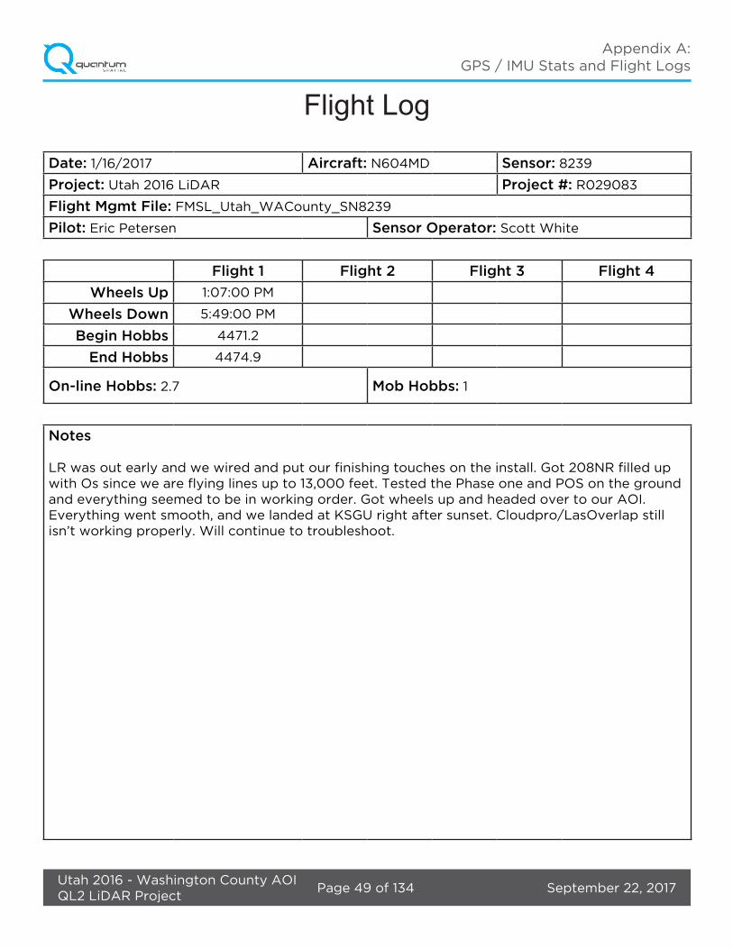
Flight Log
Date: 1/16/2017 Aircraft: N604MD Sensor: 8239
Project: Utah 2016 LiDAR Project #: R029083
Flight Mgmt File: FMSL_Utah_WACounty_SN8239
Pilot: Eric Petersen Sensor Operator: Scott White
Flight 1 Flight 2 Flight 3 Flight 4
Wheels Up 1:07:00 PM
Wheels Down 5:49:00 PM
Begin Hobbs 4471.2
End Hobbs 4474.9
On-line Hobbs: 2.7 Mob Hobbs: 1
Notes
LR was out early and we wired and put our finishing touches on the install. Got 208NR filled up with Os since we are flying lines up to 13,000 feet. Tested the Phase one and POS on the ground and everything seemed to be in working order. Got wheels up and headed over to our AOI. Everything went smooth, and we landed at KSGU right after sunset. Cloudpro/LasOverlap still isn’t working properly. Will continue to troubleshoot.
September 22, 2017Page 50 of 134Utah 2016 - Washington County AOIQL2 LiDAR Project
Appendix A: GPS / IMU Stats and Flight Logs
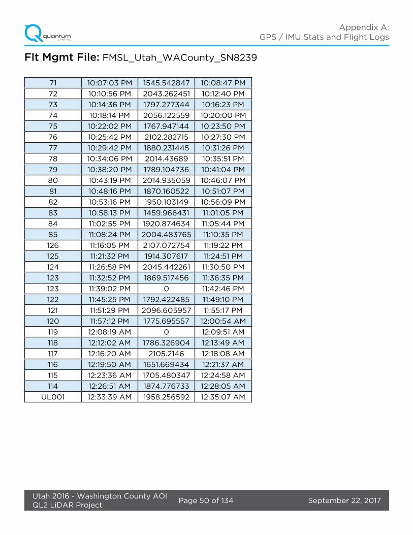
Flt Mgmt File: FMSL_Utah_WACounty_SN8239
71 10:07:03 PM 1545.542847 10:08:47 PM
72 10:10:56 PM 2043.262451 10:12:40 PM
73 10:14:36 PM 1797.277344 10:16:23 PM
74 10:18:14 PM 2056.122559 10:20:00 PM
75 10:22:02 PM 1767.947144 10:23:50 PM
76 10:25:42 PM 2102.282715 10:27:30 PM
77 10:29:42 PM 1880.231445 10:31:26 PM
78 10:34:06 PM 2014.43689 10:35:51 PM
79 10:38:20 PM 1789.104736 10:41:04 PM
80 10:43:19 PM 2014.935059 10:46:07 PM
81 10:48:16 PM 1870.160522 10:51:07 PM
82 10:53:16 PM 1950.103149 10:56:09 PM
83 10:58:13 PM 1459.966431 11:01:05 PM
84 11:02:55 PM 1920.874634 11:05:44 PM
85 11:08:24 PM 2004.483765 11:10:35 PM
126 11:16:05 PM 2107.072754 11:19:22 PM
125 11:21:32 PM 1914.307617 11:24:51 PM
124 11:26:58 PM 2045.442261 11:30:50 PM
123 11:32:52 PM 1869.517456 11:36:35 PM
123 11:39:02 PM 0 11:42:46 PM
122 11:45:25 PM 1792.422485 11:49:10 PM
121 11:51:29 PM 2096.605957 11:55:17 PM
120 11:57:12 PM 1775.695557 12:00:54 AM
119 12:08:19 AM 0 12:09:51 AM
118 12:12:02 AM 1786.326904 12:13:49 AM
117 12:16:20 AM 2105.2146 12:18:08 AM
116 12:19:50 AM 1651.669434 12:21:37 AM
115 12:23:36 AM 1705.480347 12:24:58 AM
114 12:26:51 AM 1874.776733 12:28:05 AM
UL001 12:33:39 AM 1958.256592 12:35:07 AM
September 22, 2017Page 51 of 134Utah 2016 - Washington County AOIQL2 LiDAR Project
Appendix A: GPS / IMU Stats and Flight Logs
Jan 17, 2017-A (N208NR, SN8239)
September 22, 2017Page 52 of 134Utah 2016 - Washington County AOIQL2 LiDAR Project
Appendix A: GPS / IMU Stats and Flight Logs
September 22, 2017Page 53 of 134Utah 2016 - Washington County AOIQL2 LiDAR Project
Appendix A: GPS / IMU Stats and Flight Logs

September 22, 2017Page 54 of 134Utah 2016 - Washington County AOIQL2 LiDAR Project
Appendix A: GPS / IMU Stats and Flight Logs
September 22, 2017Page 55 of 134Utah 2016 - Washington County AOIQL2 LiDAR Project
Appendix A: GPS / IMU Stats and Flight Logs

September 22, 2017Page 56 of 134Utah 2016 - Washington County AOIQL2 LiDAR Project
Appendix A: GPS / IMU Stats and Flight Logs
September 22, 2017Page 57 of 134Utah 2016 - Washington County AOIQL2 LiDAR Project
Appendix A: GPS / IMU Stats and Flight Logs

September 22, 2017Page 58 of 134Utah 2016 - Washington County AOIQL2 LiDAR Project
Appendix A: GPS / IMU Stats and Flight Logs

September 22, 2017Page 59 of 134Utah 2016 - Washington County AOIQL2 LiDAR Project
Appendix A: GPS / IMU Stats and Flight Logs
Flight Log
Date: 1/17/2017 Aircraft: N604MD Sensor: 8239
Project: Utah 2016 LiDAR Project #: R029083
Flight Mgmt File: FMSL_Utah_WACounty_SN8239
Pilot: Eric Petersen Sensor Operator: Scott White
Flight 1 Flight 2 Flight 3 Flight 4
Wheels Up 10:43:00 AM
Wheels Down 4:22:00 PM
Begin Hobbs 4474.9
End Hobbs 4480.5
On-line Hobbs: 5.4 Mob Hobbs: 0.2
Notes
Got a good lift today after some frost melted off 208NR that was present in the morning. We got lucky with snow, with multiple blocks that had snow just outside of the buffered AOI. I flew what was snow free, and made a snow KML and took Pictures of what isn’t. Overall we got the most done we have in a day for this project.

September 22, 2017Page 60 of 134Utah 2016 - Washington County AOIQL2 LiDAR Project
Appendix A: GPS / IMU Stats and Flight Logs
Flt Mgmt File: FMSL_Utah_WACounty_SN8239
112 6:10:00 PM 0 6:11:00 PM
111 6:12:00 PM 2120.916504 6:17:00 PM
110 6:19:00 PM 1724.387939 6:24:00 PM
109 6:26:00 PM 2108.335205 6:32:00 PM
108 6:34:00 PM 1842.457031 6:40:00 PM
107 6:42:00 PM 2096.730957 6:48:00 PM
106 6:51:00 PM 1564.759277 6:56:00 PM
105 6:58:00 PM 1660.822388 7:04:00 PM
104 7:06:00 PM 1914.840088 7:11:00 PM
113 7:16:00 PM 1531.220215 7:18:00 PM
103 7:21:00 PM 1430.161987 7:22:00 PM
102 7:24:00 PM 1891.166138 7:25:00 PM
101 7:27:00 PM 1926.796143 7:28:00 PM
100 7:31:00 PM 2073.029541 7:33:00 PM
99 7:36:00 PM 1490.03833 7:38:00 PM
98 7:40:00 PM 2138.995605 7:43:00 PM
97 7:45:00 PM 1571.67395 7:47:00 PM
96 7:50:00 PM 2012.883301 7:52:00 PM
95 7:54:00 PM 1475.873779 7:55:00 PM
94 8:04:00 PM 2086.017334 8:05:00 PM
93 8:07:00 PM 1900.590332 8:09:00 PM
92 8:11:00 PM 2115.168701 8:13:00 PM
91 8:15:00 PM 1884.067627 8:17:00 PM
90 8:19:00 PM 2105.510986 8:21:00 PM
89 8:23:00 PM 1699.329224 8:25:00 PM
88 8:27:00 PM 2093.920898 8:29:00 PM
87 8:31:00 PM 1584.920898 8:33:00 PM
86 8:35:00 PM 2147.880371 8:37:00 PM
70 8:42:00 PM 1425.903198 8:45:00 PM
70 8:48:00 PM 2072.453613 8:51:00 PM
69 8:54:00 PM 1649.715332 8:57:00 PM
68 9:10:00 PM 2041.874146 9:13:00 PM
67 9:15:00 PM 1749.58728 9:19:00 PM
66 9:21:00 PM 2096.771729 9:25:00 PM
65 9:27:00 PM 1858.795044 9:31:00 PM
64 9:33:00 PM 1972.563965 9:36:00 PM
63 9:39:00 PM 1859.664795 9:41:00 PM

September 22, 2017Page 61 of 134Utah 2016 - Washington County AOIQL2 LiDAR Project
Appendix A: GPS / IMU Stats and Flight Logs
NameStartTime
(UTC)Start AGL
(m)End Time
(UTC)
62 9:45:00 PM 2102.90625 9:48:00 PM
61 9:49:00 PM 1561.720215 9:53:00 PM
60 9:56:00 PM 1680.026367 10:00:00 PM
59 10:01:00 PM 1680.789063 10:05:00 PM
58 10:08:00 PM 1625.091919 10:11:00 PM
57 10:14:00 PM 1808.301025 10:17:00 PM
56 10:19:00 PM 1847.973511 10:22:00 PM
55 10:24:00 PM 1699.771729 10:27:00 PM
54 10:29:00 PM 1932.793701 10:31:00 PM
53 10:33:00 PM 1979.743408 10:34:00 PM
52 10:37:00 PM 1726.783325 10:38:00 PM
191 10:47:00 PM 1977.496704 10:48:00 PM
190 10:51:00 PM 2118.955322 10:52:00 PM
189 10:54:00 PM 2057.638184 10:56:00 PM
188 10:58:00 PM 2081.019531 11:00:00 PM
UL001 7:58:00 PM 0 8:00:00 PM
UL002 11:02:00 PM 2058.72876 11:03:00 PM
September 22, 2017Page 62 of 134Utah 2016 - Washington County AOIQL2 LiDAR Project
Appendix A: GPS / IMU Stats and Flight Logs
Mar 9, 2017-A (N704MD, SN8121)

September 22, 2017Page 63 of 134Utah 2016 - Washington County AOIQL2 LiDAR Project
Appendix A: GPS / IMU Stats and Flight Logs
September 22, 2017Page 64 of 134Utah 2016 - Washington County AOIQL2 LiDAR Project
Appendix A: GPS / IMU Stats and Flight Logs

September 22, 2017Page 65 of 134Utah 2016 - Washington County AOIQL2 LiDAR Project
Appendix A: GPS / IMU Stats and Flight Logs
September 22, 2017Page 66 of 134Utah 2016 - Washington County AOIQL2 LiDAR Project
Appendix A: GPS / IMU Stats and Flight Logs

September 22, 2017Page 67 of 134Utah 2016 - Washington County AOIQL2 LiDAR Project
Appendix A: GPS / IMU Stats and Flight Logs
September 22, 2017Page 68 of 134Utah 2016 - Washington County AOIQL2 LiDAR Project
Appendix A: GPS / IMU Stats and Flight Logs
September 22, 2017Page 69 of 134Utah 2016 - Washington County AOIQL2 LiDAR Project
Appendix A: GPS / IMU Stats and Flight Logs
September 22, 2017Page 70 of 134Utah 2016 - Washington County AOIQL2 LiDAR Project
Appendix A: GPS / IMU Stats and Flight Logs
Flight Log
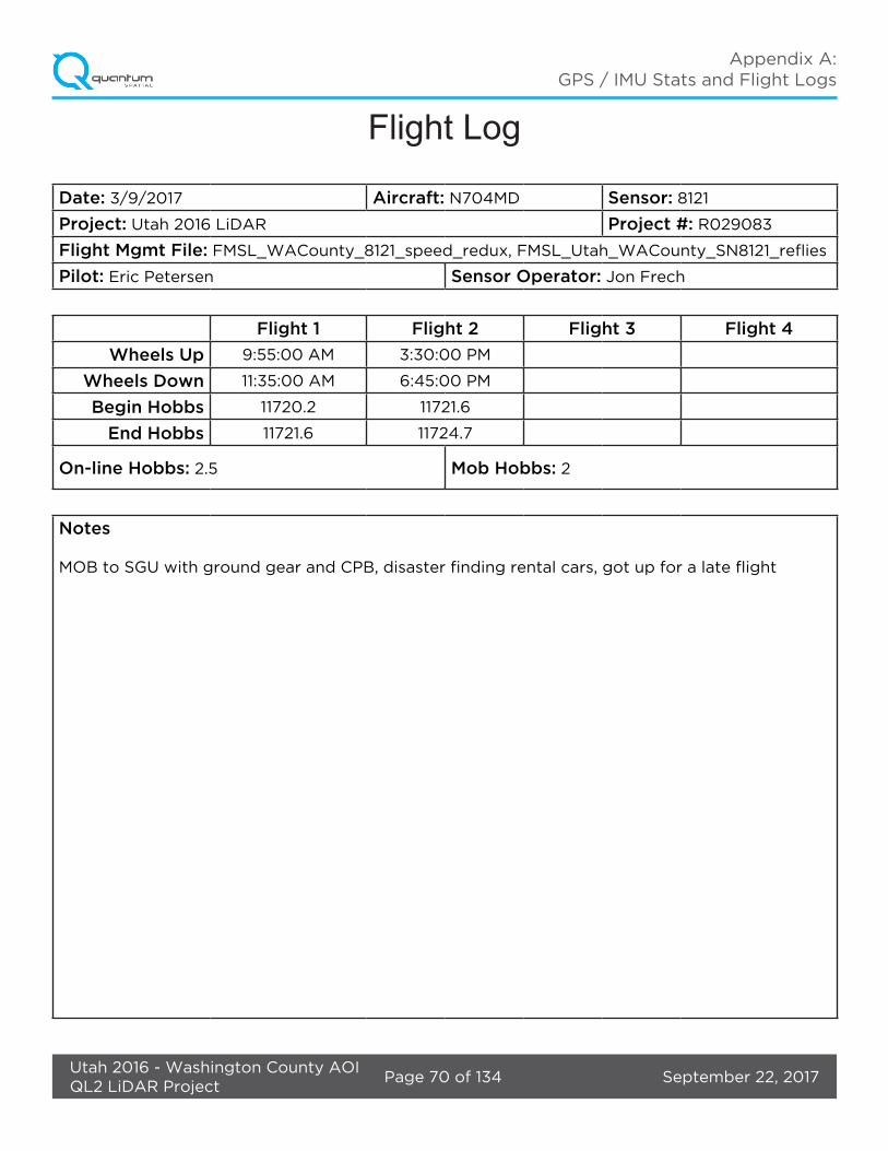
Date: 3/9/2017 Aircraft: N704MD Sensor: 8121
Project: Utah 2016 LiDAR Project #: R029083
Flight Mgmt File: FMSL_WACounty_8121_speed_redux, FMSL_Utah_WACounty_SN8121_reflies
Pilot: Eric Petersen Sensor Operator: Jon Frech
Flight 1 Flight 2 Flight 3 Flight 4
Wheels Up 9:55:00 AM 3:30:00 PM
Wheels Down 11:35:00 AM 6:45:00 PM
Begin Hobbs 11720.2 11721.6
End Hobbs 11721.6 11724.7
On-line Hobbs: 2.5 Mob Hobbs: 2
Notes
MOB to SGU with ground gear and CPB, disaster finding rental cars, got up for a late flight
September 22, 2017Page 71 of 134Utah 2016 - Washington County AOIQL2 LiDAR Project
Appendix A: GPS / IMU Stats and Flight Logs
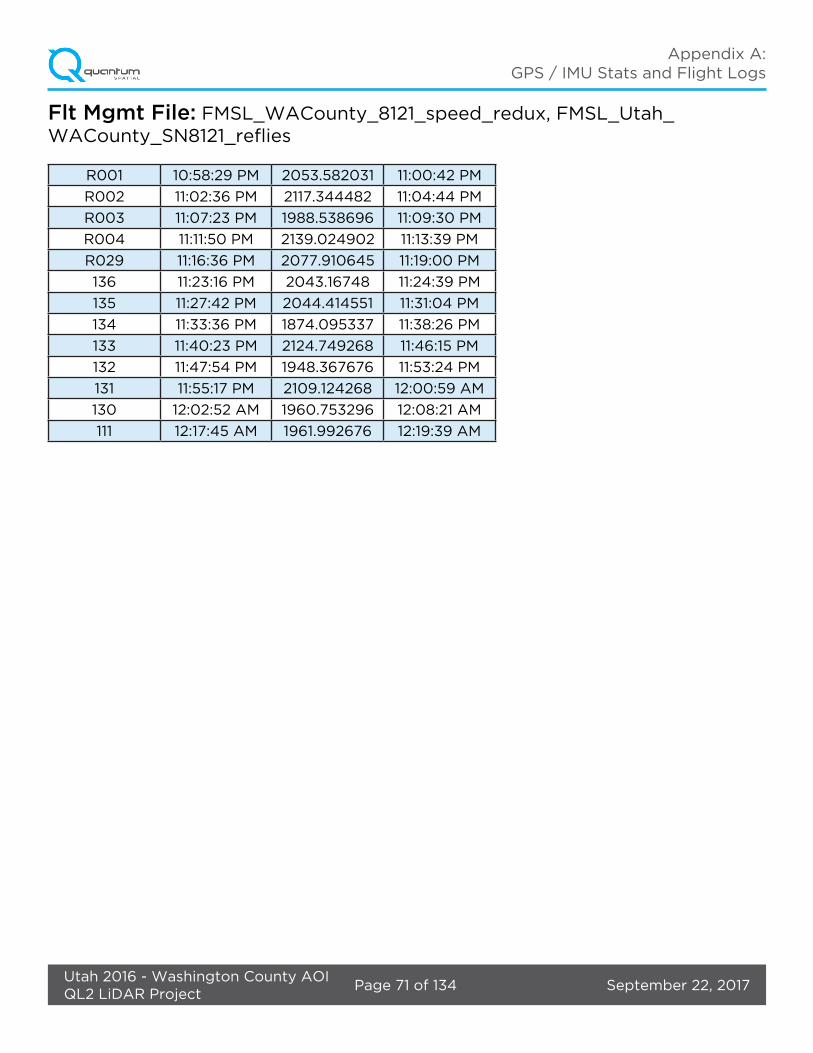
Flt Mgmt File: FMSL_WACounty_8121_speed_redux, FMSL_Utah_WACounty_SN8121_reflies
R001 10:58:29 PM 2053.582031 11:00:42 PM
R002 11:02:36 PM 2117.344482 11:04:44 PM
R003 11:07:23 PM 1988.538696 11:09:30 PM
R004 11:11:50 PM 2139.024902 11:13:39 PM
R029 11:16:36 PM 2077.910645 11:19:00 PM
136 11:23:16 PM 2043.16748 11:24:39 PM
135 11:27:42 PM 2044.414551 11:31:04 PM
134 11:33:36 PM 1874.095337 11:38:26 PM
133 11:40:23 PM 2124.749268 11:46:15 PM
132 11:47:54 PM 1948.367676 11:53:24 PM
131 11:55:17 PM 2109.124268 12:00:59 AM
130 12:02:52 AM 1960.753296 12:08:21 AM
111 12:17:45 AM 1961.992676 12:19:39 AM

September 22, 2017Page 72 of 134Utah 2016 - Washington County AOIQL2 LiDAR Project
Appendix A: GPS / IMU Stats and Flight Logs
Mar 9, 2017-B (N704MD, SN8121)

September 22, 2017Page 73 of 134Utah 2016 - Washington County AOIQL2 LiDAR Project
Appendix A: GPS / IMU Stats and Flight Logs

September 22, 2017Page 74 of 134Utah 2016 - Washington County AOIQL2 LiDAR Project
Appendix A: GPS / IMU Stats and Flight Logs
September 22, 2017Page 75 of 134Utah 2016 - Washington County AOIQL2 LiDAR Project
Appendix A: GPS / IMU Stats and Flight Logs

September 22, 2017Page 76 of 134Utah 2016 - Washington County AOIQL2 LiDAR Project
Appendix A: GPS / IMU Stats and Flight Logs
September 22, 2017Page 77 of 134Utah 2016 - Washington County AOIQL2 LiDAR Project
Appendix A: GPS / IMU Stats and Flight Logs

September 22, 2017Page 78 of 134Utah 2016 - Washington County AOIQL2 LiDAR Project
Appendix A: GPS / IMU Stats and Flight Logs
September 22, 2017Page 79 of 134Utah 2016 - Washington County AOIQL2 LiDAR Project
Appendix A: GPS / IMU Stats and Flight Logs
Flight Log
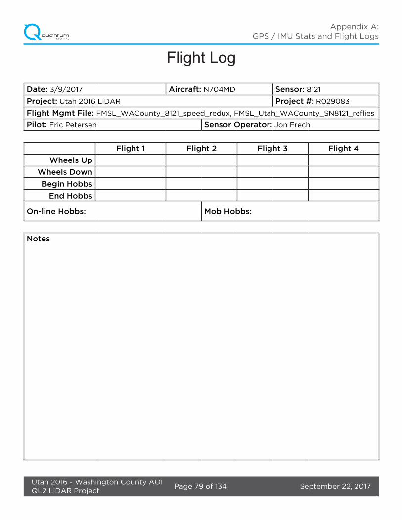
Date: 3/9/2017 Aircraft: N704MD Sensor: 8121
Project: Utah 2016 LiDAR Project #: R029083
Flight Mgmt File: FMSL_WACounty_8121_speed_redux, FMSL_Utah_WACounty_SN8121_reflies
Pilot: Eric Petersen Sensor Operator: Jon Frech
Flight 1 Flight 2 Flight 3 Flight 4
Wheels Up
Wheels Down
Begin Hobbs
End Hobbs
On-line Hobbs: Mob Hobbs:
Notes
September 22, 2017Page 80 of 134Utah 2016 - Washington County AOIQL2 LiDAR Project
Appendix A: GPS / IMU Stats and Flight Logs
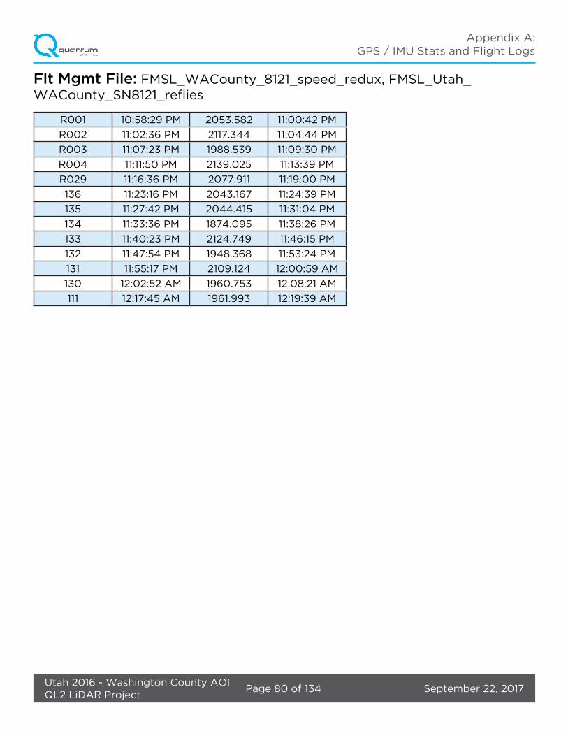
Flt Mgmt File: FMSL_WACounty_8121_speed_redux, FMSL_Utah_WACounty_SN8121_reflies
R001 10:58:29 PM 2053.582 11:00:42 PM
R002 11:02:36 PM 2117.344 11:04:44 PM
R003 11:07:23 PM 1988.539 11:09:30 PM
R004 11:11:50 PM 2139.025 11:13:39 PM
R029 11:16:36 PM 2077.911 11:19:00 PM
136 11:23:16 PM 2043.167 11:24:39 PM
135 11:27:42 PM 2044.415 11:31:04 PM
134 11:33:36 PM 1874.095 11:38:26 PM
133 11:40:23 PM 2124.749 11:46:15 PM
132 11:47:54 PM 1948.368 11:53:24 PM
131 11:55:17 PM 2109.124 12:00:59 AM
130 12:02:52 AM 1960.753 12:08:21 AM
111 12:17:45 AM 1961.993 12:19:39 AM
September 22, 2017Page 81 of 134Utah 2016 - Washington County AOIQL2 LiDAR Project
Appendix A: GPS / IMU Stats and Flight Logs
Mar 10, 2017-A (N704MD, SN8121)
September 22, 2017Page 82 of 134Utah 2016 - Washington County AOIQL2 LiDAR Project
Appendix A: GPS / IMU Stats and Flight Logs
September 22, 2017Page 83 of 134Utah 2016 - Washington County AOIQL2 LiDAR Project
Appendix A: GPS / IMU Stats and Flight Logs

September 22, 2017Page 84 of 134Utah 2016 - Washington County AOIQL2 LiDAR Project
Appendix A: GPS / IMU Stats and Flight Logs

September 22, 2017Page 85 of 134Utah 2016 - Washington County AOIQL2 LiDAR Project
Appendix A: GPS / IMU Stats and Flight Logs

September 22, 2017Page 86 of 134Utah 2016 - Washington County AOIQL2 LiDAR Project
Appendix A: GPS / IMU Stats and Flight Logs

September 22, 2017Page 87 of 134Utah 2016 - Washington County AOIQL2 LiDAR Project
Appendix A: GPS / IMU Stats and Flight Logs

September 22, 2017Page 88 of 134Utah 2016 - Washington County AOIQL2 LiDAR Project
Appendix A: GPS / IMU Stats and Flight Logs
September 22, 2017Page 89 of 134Utah 2016 - Washington County AOIQL2 LiDAR Project
Appendix A: GPS / IMU Stats and Flight Logs
Flight LogDate: 3/10/2017 Aircraft: N704MD Sensor: 8121
Project: Utah 2016 LiDAR Project #: R029083
Flight Mgmt File: FMSL_WACounty_8121_speed_redux, FMSL_Utah_WACounty_SN8121_reflies
Pilot: Eric Petersen Sensor Operator: Jon Frech
Flight 1 Flight 2 Flight 3 Flight 4
Wheels Up 9:35:00 AM
Wheels Down 2:55:00 PM
Begin Hobbs 11724.7
End Hobbs 11729.7
On-line Hobbs: 4.3 Mob Hobbs: 0.7
Notes
Finished reflies and all snow free areas of washington county
September 22, 2017Page 90 of 134Utah 2016 - Washington County AOIQL2 LiDAR Project
Appendix A: GPS / IMU Stats and Flight Logs
Flt Mgmt File: FMSL_WACounty_8121_speed_redux, FMSL_Utah_WACounty_SN8121_reflies
R033 12:35:00 AM 2079.244873 12:35:53 AM
R032 12:38:38 AM 1879.702026 12:39:27 AM
R014 12:48:05 AM 1627.617065 12:50:11 AM
R015 12:54:04 AM 1857.729004 12:59:04 AM
R016 1:00:46 AM 1988.139038 1:05:48 AM
R017 1:07:38 AM 2007.612915 1:12:42 AM
R018 1:14:32 AM 2089.651367 1:16:46 AM
R019 1:18:56 AM 1993.693604 1:20:33 AM
R030 1:24:47 AM 1642.352417 1:27:31 AM
September 22, 2017Page 91 of 134Utah 2016 - Washington County AOIQL2 LiDAR Project
Appendix A: GPS / IMU Stats and Flight Logs
Jun 11, 2017-A (N704MD, SN7161)
September 22, 2017Page 92 of 134Utah 2016 - Washington County AOIQL2 LiDAR Project
Appendix A: GPS / IMU Stats and Flight Logs

September 22, 2017Page 93 of 134Utah 2016 - Washington County AOIQL2 LiDAR Project
Appendix A: GPS / IMU Stats and Flight Logs

September 22, 2017Page 94 of 134Utah 2016 - Washington County AOIQL2 LiDAR Project
Appendix A: GPS / IMU Stats and Flight Logs

September 22, 2017Page 95 of 134Utah 2016 - Washington County AOIQL2 LiDAR Project
Appendix A: GPS / IMU Stats and Flight Logs

September 22, 2017Page 96 of 134Utah 2016 - Washington County AOIQL2 LiDAR Project
Appendix A: GPS / IMU Stats and Flight Logs

September 22, 2017Page 97 of 134Utah 2016 - Washington County AOIQL2 LiDAR Project
Appendix A: GPS / IMU Stats and Flight Logs
September 22, 2017Page 98 of 134Utah 2016 - Washington County AOIQL2 LiDAR Project
Appendix A: GPS / IMU Stats and Flight Logs
September 22, 2017Page 99 of 134Utah 2016 - Washington County AOIQL2 LiDAR Project
Appendix A: GPS / IMU Stats and Flight Logs
Flight Log
Date: 6/11/2017 Aircraft: N704MD Sensor: 7161
Project: Utah 2016 LiDAR Project #: R029083
Flight Mgmt File: FMSL_SN7161_WACounty
Pilot: Dave Wagner Sensor Operator: Aaron Mallon
Flight 1 Flight 2 Flight 3 Flight 4
Wheels Up 8:10:00 AM
Wheels Down 9:45:00 AM
Begin Hobbs 11882.5
End Hobbs 11884.1
On-line Hobbs: 0.5 Mob Hobbs: 1.1
Notes
Today we were ready to have wheels up at 0700, however, when we arrived at the airport our plane had not been fueled. We encountered clouds in on area of the AOI and were forced to go fly lines 076-081 off or CORS.
September 22, 2017Page 100 of 134Utah 2016 - Washington County AOIQL2 LiDAR Project
Appendix A: GPS / IMU Stats and Flight Logs
Jun 13, 2017-A (N704MD, SN7161)

September 22, 2017Page 101 of 134Utah 2016 - Washington County AOIQL2 LiDAR Project
Appendix A: GPS / IMU Stats and Flight Logs
September 22, 2017Page 102 of 134Utah 2016 - Washington County AOIQL2 LiDAR Project
Appendix A: GPS / IMU Stats and Flight Logs

September 22, 2017Page 103 of 134Utah 2016 - Washington County AOIQL2 LiDAR Project
Appendix A: GPS / IMU Stats and Flight Logs
September 22, 2017Page 104 of 134Utah 2016 - Washington County AOIQL2 LiDAR Project
Appendix A: GPS / IMU Stats and Flight Logs

September 22, 2017Page 105 of 134Utah 2016 - Washington County AOIQL2 LiDAR Project
Appendix A: GPS / IMU Stats and Flight Logs

September 22, 2017Page 106 of 134Utah 2016 - Washington County AOIQL2 LiDAR Project
Appendix A: GPS / IMU Stats and Flight Logs

September 22, 2017Page 107 of 134Utah 2016 - Washington County AOIQL2 LiDAR Project
Appendix A: GPS / IMU Stats and Flight Logs
September 22, 2017Page 108 of 134Utah 2016 - Washington County AOIQL2 LiDAR Project
Appendix A: GPS / IMU Stats and Flight Logs
Flight Log
Date: 6/13/2017 Aircraft: N704MD Sensor: 7161
Project: Utah 2016 LiDAR Project #: R029083
Flight Mgmt File: FMSL_WACounty_7161
Pilot: Dave Wagner Sensor Operator: Drew Johnston
Flight 1 Flight 2 Flight 3 Flight 4
Wheels Up 8:24:00 AM
Wheels Down 1:01:00 PM
Begin Hobbs 1184.1
End Hobbs 1188.7
On-line Hobbs: 6 Mob Hobbs: 1.2
Notes
We had many delays/reflies because of the als70 acting up (false ranges shutting off naked eyesafe?), and range violations/dropouts due to the plan/DEM not taking into account the seriousness of the many canyons. The cliffs are very steep, and a side of the swath could be in a very deep trench that wasn’t accounted for in the initial planning. We reflew lines that had dropouts, and flew 3 crosslines along the ‘trouble’ canyons where we had the most issues. We also battled very high winds aloft and turb throughout the day, forcing us to fly a block S-N w/o alternating directions as DW was concerned about stalls. 7.2 is about the max-pain for such flights. Doing a full QL tonight to see how things turned out.

September 22, 2017Page 109 of 134Utah 2016 - Washington County AOIQL2 LiDAR Project
Appendix A: GPS / IMU Stats and Flight Logs
Jun 13, 2017-B (N704MD, SN7161)
September 22, 2017Page 110 of 134Utah 2016 - Washington County AOIQL2 LiDAR Project
Appendix A: GPS / IMU Stats and Flight Logs

September 22, 2017Page 111 of 134Utah 2016 - Washington County AOIQL2 LiDAR Project
Appendix A: GPS / IMU Stats and Flight Logs

September 22, 2017Page 112 of 134Utah 2016 - Washington County AOIQL2 LiDAR Project
Appendix A: GPS / IMU Stats and Flight Logs
September 22, 2017Page 113 of 134Utah 2016 - Washington County AOIQL2 LiDAR Project
Appendix A: GPS / IMU Stats and Flight Logs

September 22, 2017Page 114 of 134Utah 2016 - Washington County AOIQL2 LiDAR Project
Appendix A: GPS / IMU Stats and Flight Logs

September 22, 2017Page 115 of 134Utah 2016 - Washington County AOIQL2 LiDAR Project
Appendix A: GPS / IMU Stats and Flight Logs
September 22, 2017Page 116 of 134Utah 2016 - Washington County AOIQL2 LiDAR Project
Appendix A: GPS / IMU Stats and Flight Logs

September 22, 2017Page 117 of 134Utah 2016 - Washington County AOIQL2 LiDAR Project
Appendix A: GPS / IMU Stats and Flight Logs
Flight Log
Date: 6/13/2017 Aircraft: N704MD Sensor: 7161
Project: Utah 2016 LiDAR Project #: R029083
Flight Mgmt File: FMSL_WACounty_7161
Pilot: Dave Wagner Sensor Operator: Drew Johnston
Flight 1 Flight 2 Flight 3 Flight 4
Wheels Up 8:24:00 AM
Wheels Down 1:01:00 PM
Begin Hobbs 1184.1
End Hobbs 1188.7
On-line Hobbs: 6 Mob Hobbs: 1.2
Notes
We had many delays/reflies because of the als70 acting up (false ranges shutting off naked eyesafe?), and range violations/dropouts due to the plan/DEM not taking into account the seriousness of the many canyons. The cliffs are very steep, and a side of the swath could be in a very deep trench that wasn’t accounted for in the initial planning. We reflew lines that had dropouts, and flew 3 crosslines along the ‘trouble’ canyons where we had the most issues. We also battled very high winds aloft and turb throughout the day, forcing us to fly a block S-N w/o alternating directions as DW was concerned about stalls. 7.2 is about the max-pain for such flights. Doing a full QL tonight to see how things turned out.

September 22, 2017Page 118 of 134Utah 2016 - Washington County AOIQL2 LiDAR Project
Appendix A: GPS / IMU Stats and Flight Logs
Jun 14, 2017-A (N704MD, SN7161)

September 22, 2017Page 119 of 134Utah 2016 - Washington County AOIQL2 LiDAR Project
Appendix A: GPS / IMU Stats and Flight Logs

September 22, 2017Page 120 of 134Utah 2016 - Washington County AOIQL2 LiDAR Project
Appendix A: GPS / IMU Stats and Flight Logs

September 22, 2017Page 121 of 134Utah 2016 - Washington County AOIQL2 LiDAR Project
Appendix A: GPS / IMU Stats and Flight Logs

September 22, 2017Page 122 of 134Utah 2016 - Washington County AOIQL2 LiDAR Project
Appendix A: GPS / IMU Stats and Flight Logs

September 22, 2017Page 123 of 134Utah 2016 - Washington County AOIQL2 LiDAR Project
Appendix A: GPS / IMU Stats and Flight Logs

September 22, 2017Page 124 of 134Utah 2016 - Washington County AOIQL2 LiDAR Project
Appendix A: GPS / IMU Stats and Flight Logs

September 22, 2017Page 125 of 134Utah 2016 - Washington County AOIQL2 LiDAR Project
Appendix A: GPS / IMU Stats and Flight Logs

September 22, 2017Page 126 of 134Utah 2016 - Washington County AOIQL2 LiDAR Project
Appendix A: GPS / IMU Stats and Flight Logs
Flight Log
Date: 6/14/2017 Aircraft: 704MD Sensor: 7161
Project: Utah 2016 LiDAR Project #: R029083
Flight Mgmt File: FMSL_WACounty_7161
Pilot: Dave Wagner Sensor Operator: Drew Johnston
Flight 1 Flight 2 Flight 3 Flight 4
Wheels Up 8:14:00 PM
Wheels Down 10:44:00 AM
Begin Hobbs 1191.3
End Hobbs 1193.8
On-line Hobbs: 1.8 Mob Hobbs: 0.7
Notes
Had a TDC error twice this morning, once at startup and again in the air. In air startup had trouble finding pos. Did a restart, wagged the tail of the plane, ups and downs, and it found itself. 10 minutes, then started ACQ. Northern block east ends of the lines were too high when entering the line, but this had overlap from the block we flew first so we continued on.
September 22, 2017Page 127 of 134Utah 2016 - Washington County AOIQL2 LiDAR Project
Appendix A: GPS / IMU Stats and Flight Logs
Jul 14, 2017-A (N704MD, SN8239)

September 22, 2017Page 128 of 134Utah 2016 - Washington County AOIQL2 LiDAR Project
Appendix A: GPS / IMU Stats and Flight Logs
September 22, 2017Page 129 of 134Utah 2016 - Washington County AOIQL2 LiDAR Project
Appendix A: GPS / IMU Stats and Flight Logs
September 22, 2017Page 130 of 134Utah 2016 - Washington County AOIQL2 LiDAR Project
Appendix A: GPS / IMU Stats and Flight Logs
September 22, 2017Page 131 of 134Utah 2016 - Washington County AOIQL2 LiDAR Project
Appendix A: GPS / IMU Stats and Flight Logs

September 22, 2017Page 132 of 134Utah 2016 - Washington County AOIQL2 LiDAR Project
Appendix A: GPS / IMU Stats and Flight Logs

September 22, 2017Page 133 of 134Utah 2016 - Washington County AOIQL2 LiDAR Project
Appendix A: GPS / IMU Stats and Flight Logs

September 22, 2017Page 134 of 134Utah 2016 - Washington County AOIQL2 LiDAR Project
Appendix A: GPS / IMU Stats and Flight Logs
Flight Log
Date: 7/14/2017 Aircraft: N704MD Sensor: 8239
Project: Utah 2016 LiDAR Project #: R029083
Flight Mgmt File: FMSL_WACounty_8239_Canyons_60ovlp
Pilot: Sean Meyer Sensor Operator: Drew Johnston
Flight 1 Flight 2 Flight 3 Flight 4
Wheels Up 9:03:00 AM 3:25:00 PM
Wheels Down 11:42:00 AM 6:27:00 PM
Begin Hobbs 1981.7 1984.3
End Hobbs 1984.3 1987.3
On-line Hobbs: 2 Mob Hobbs: 3.6
Notes
Lifted and quickly ran through data before our MOB towards Sheboygan. We are in Westminster, CO for the night.