ut ah geologic al sur vey survey notes · ut ah geologic al sur vey. survey notes ... barrel), and...
TRANSCRIPT

May 2015Volume 47, Number 2
U T A H G E O L O G I C A L S U R V E Y
SURVEY NOTES
Mars Curiosit y Mission takes Utah into O uter Space
U TA H O N M A R S

State of Utah Gary R. Herbert, Governor
Department of Natural Resources Michael Styler, Executive Director
UGS Board Tom Tripp, Chair
William Loughlin, Marc Eckels, Pete Kilbourne, Ken Fleck, Sam Quigley, Elissa Richards Kevin Carter (Trust Lands Administration-ex officio)
UGS STAFFAdministration Richard G. Allis, Director Kimm Harty, Deputy Director Starr Soliz, Secretary/Receptionist
Dianne Davis, Administrative Secretary Jodi Patterson, Financial Manager Linda Bennett, Accounting Technician Michael Hylland, Technical Reviewer Stephanie Carney, Technical Reviewer Editorial Staff | Vicky Clarke Lori Steadman, Jay Hill, Nikki Simon, John Good
Geologic Hazards | Steve Bowman Richard Giraud, William Lund, Jessica Castleton,
Gregg Beukelman, Tyler Knudsen, Greg McDonald, Adam McKean, Ben Erickson, Pam Perri, Adam Hiscock, Gordon Douglass
Geologic Information and Outreach | Michael Hylland
Christine Wilkerson, Mark Milligan, Lance Weaver, Gentry Hammerschmid, Jim Davis, Marshall Robinson, Brian Butler, Robyn Keeling, Andrew Cvar
Geologic Mapping | Grant Willis Jon King, Douglas Sprinkel, Kent Brown,
Basia Matyjasik, Donald Clark, Bob Biek, Paul Kuehne, Zach Anderson
Energy and Minerals | David Tabet Robert Blackett, Craig Morgan, Jeff Quick,
Taylor Boden, Thomas Chidsey, Cheryl Gustin, Tom Dempster, Stephanie Carney, Ken Krahulec, Mike Vanden Berg, Andrew Rupke, Mark Gwynn, Christian Hardwick, Peter Nielsen, Hobie Willis, Rebekah Wood
Groundwater and Paleontology | Mike Lowe James Kirkland, Janae Wallace, Martha Hayden,
Hugh Hurlow, Don DeBlieux, Paul Inkenbrandt, Lucy Jordan, Walid Sabbah, Rich Emerson, Stefan Kirby, Scott Madsen, Diane Menuz, Brittany Dame, Nathan Payne
Survey Notes is published three times yearly by the Utah Geological Survey, 1594 W. North Temple, Suite 3110, Salt Lake City, Utah 84116; (801) 537-3300. The UGS provides timely scientific information about Utah’s geologic environment, resources, and hazards. The UGS is a division of the Department of Natural Resources. Single copies of Survey Notes are distributed free of charge within the United States and reproduction is encouraged with recognition of source. Copies are available at geology.utah.gov/map-pub/survey-notes/. ISSN 1061-7930
ContentsUnderstanding Southeast Utah’s Cane
Creek Oil, A Continuing Challenge .......1Today’s (and Tomorrow’s?) Phosphate ......6Core Center News .....................................8Glad You Asked ......................................10GeoSights ................................................14Survey News ............................................16New Publications ....................................17
Design | Nikki Simon
Cover | Mars rover Curiosity self portrait at the “Book Cliffs” in Gale Crater on Mars.Photo courtesy of the Planetary Society. INSET PHOTO The Book Cliffs, Utah. The Blackhawk Formation caps the Mancos Shale at the mouth of Thompson Canyon east of Green River, Utah. Photo by Rebekah Wood, Utah Geological Survey.
Since fall 2014, the bench-mark oil price in the U.S. (West Texas Intermedi-ate) has declined by close to 50 percent ($95 to $47/barrel), and because Utah oil is typically discounted by $15–$20 a barrel, the local decline in revenue from oil production will be greater than 50 per-cent. In addition, the warm winter has resulted in the natural gas supply exceeding demand, caus-ing a price decline of about 40 per-cent (from $4 to about $2.40/mcf). Assuming the present low prices continue, we expect the effect on Mineral Lease revenue to the Utah Geological Survey (UGS) to be a decrease from fiscal year (FY) 14 levels of about $0.5 million in the rest of FY15, and about $1.5 mil-lion in FY16. This is having a large impact on our total budget of $8.5 million in FY14, and has unfortu-nately forced us to layoff four staff.
The 2015 legislature that has just ended included two funding appro-priations for the UGS that will be very helpful for dealing with the rapid decline in Mineral Lease roy-alty payments. It approved our request for ongoing funding for two geologic hazard mappers, which fortunately was initiated last summer before oil and gas price declines had started. The legislature also recognized the exceptional circumstances of the UGS revenue decline and approved a one-time request of $300,000, which pro-vides more time for the UGS to adjust to the diminished revenue. It has also been helpful that the UGS happens to be in a phase when the rate of retirements has accelerated, with three already in FY15 and four
more expected in FY16. By using the savings from retirements, cutting out discretionary expenditure, and pursuing all external revenue opportunities, the UGS hopes to get its budget back into balance.
The challenges faced by the UGS are a microcosm
of what is happening across Utah’s oil and gas-producing counties. The number of operat-ing drill rigs in Utah has declined from around 27 last summer to 8 at the start of April. Last year 900 wells were completed, so during 2015 this number will probably be at least halved. The average cost of wells depends on depth and the completion process, but at $3–5 million per well, the impact is at least $1–2 billion. The annual value to Utah of oil and natural gas production in recent years has been about $4 billion (calculated from wellhead production price and volume). The magnitude of the price decline over the past six months confirms a multi-billion dollar financial impact to Utah’s petroleum sector.
However, other sectors of the economy will likely benefit from the drop in fuel prices. Economists have estimated the average annual per-person savings from the gaso-line price reductions will approach $1000. This suggests increased discretionary spending, so with Utah being a popular travel des-tination, we can expect the tour-ist and recreation sectors to have a boom time this summer. There are winners and losers when major changes occur with our essential commodities.
THE DIRECTOR'S PERSPECTIVE
by Richard G. Allis

INTRODUCTIONThe Cane Creek shale of the Paradox Formation in southeastern Utah has been a challenging oil reservoir to develop. As part of a three-year U.S. Department of Energy-funded study, the Utah Geological Survey (UGS) has been researching the Cane Creek shale, characterizing its geologic, geomechanical, and geochemical properties throughout the Paradox Basin. The goal of improved reservoir characterization is to identify potential exploration areas outside the current Cane Creek unit near Dead Horse Point State Park, as well as improve drilling and production techniques to reduce costs and environmental impacts.
DRILLING HISTORY
Over the past decade, the Moab area of the Paradox Basin has seen a large increase in drilling and subsequent oil production. The first oil discovery in the Moab area occurred in the 1920s from the 300-million-year-old (Pennsylvanian- aged) Paradox Formation. Drilling equipment and building materials were loaded on barges and floated down the Colorado River to where the first discovery was drilled on the axis of the Cane Creek anticline near the current site of the Moab potash mine. While drilling, the well blew out at a depth of 2028 feet and the rig was destroyed by the resulting fire. Several additional wells were drilled on the anticline, but only a minor amount of oil was produced. Later, the equipment was floated farther down the river to Shafer dome, which resulted in drilling a dry hole.
Understanding Southeast Utah’s Cane Creek Oil,
A Continuing ChallengeB Y Craig D. Morgan
In 1957, drilling up on Big Flat, near present-day Dead Horse Point State Park, resulted in the discovery of oil in the Mississippian Redwall Limestone. This was the first discovery of oil from Mississippian-aged rocks in Utah. Ultimately, three oil wells and four dry holes were drilled in the Big Flat field, which was abandoned in 1971 after producing more than 83,000 barrels of oil (BO).
The early 1960s saw the discovery of the Shafer Canyon, Bartlett Flat, and Long Canyon fields. The Shafer
Paradox Basin in southeast Utah and southwest Colorado. The approximate limit of the Cane Creek play is based on the mapped extent of the Cane Creek shale in Utah.
Red boxes are areas with Cane Creek oil production.
MAY 2015 1
Colorado R
iver
UTA
HC
OLO
RA
DO
PARADOX
BASIN
0 25 50 Miles
GrandJunction
Moab
GreenRiver ●
●
●
Approximate limit of Cane Creek Play
Monticello●
Dead Horse PointState Park
●

Canyon field consisted of two wells, one on each side of Dead Horse Point State Park, which produced from the Cane Creek shale. The wells were plugged and abandoned in 1969 after producing over 67,000 BO, mostly from one well. Bartlett Flat (Big Flat 5 well) and Long Canyon (Long Canyon 1 well) fields (both one-well fields) also produced from the Cane Creek shale. The casing collapsed in the Big Flat 5 well and the field was abandoned after producing 39,000 BO. Several additional wells unsuccessfully attempted to establish production
Oil and gas wells in the Moab region, some dating back to the 1920s. Current oil drilling and production is from wells in the Cane Creek Federal unit. Many of the wells in the unit were drilled horizontally in the
Cane Creek shale, and some horizontal laterals are thousands of feet in length.
at Bartlett Flat. The Long Canyon well was the most successful well in the area drilled during the 1960s. The well has produced more than 1 million BO and is still producing. Lion Mesa field was discovered in 1980, but has only produced a minor amount of oil from the Cane Creek shale.
Exploration continued in the Moab area, but significant success did not occur until Columbia Gas Development Corporation formed the Cane Creek Federal unit in 1991 and drilled a horizontal well (1-27) in the Cane
2 SURVEY NOTES
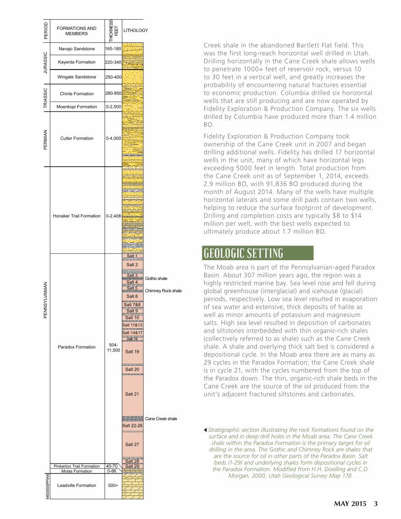
Stratigraphic section illustrating the rock formations found on the surface and in deep drill holes in the Moab area. The Cane Creek shale within the Paradox Formation is the primary target for oil
drilling in the area. The Gothic and Chimney Rock are shales that are the source for oil in other parts of the Paradox Basin. Salt beds (1-29) and underlying shales form depositional cycles in
the Paradox Formation. Modified from H.H. Doelling and C.D. Morgan, 2000, Utah Geological Survey Map 178.
Creek shale in the abandoned Bartlett Flat field. This was the first long-reach horizontal well drilled in Utah. Drilling horizontally in the Cane Creek shale allows wells to penetrate 1000+ feet of reservoir rock, versus 10 to 30 feet in a vertical well, and greatly increases the probability of encountering natural fractures essential to economic production. Columbia drilled six horizontal wells that are still producing and are now operated by Fidelity Exploration & Production Company. The six wells drilled by Columbia have produced more than 1.4 million BO.
Fidelity Exploration & Production Company took ownership of the Cane Creek unit in 2007 and began drilling additional wells. Fidelity has drilled 17 horizontal wells in the unit, many of which have horizontal legs exceeding 5000 feet in length. Total production from the Cane Creek unit as of September 1, 2014, exceeds 2.9 million BO, with 91,836 BO produced during the month of August 2014. Many of the wells have multiple horizontal laterals and some drill pads contain two wells, helping to reduce the surface footprint of development. Drilling and completion costs are typically $8 to $14 million per well, with the best wells expected to ultimately produce about 1.7 million BO.
GEOLOGIC SETTINGThe Moab area is part of the Pennsylvanian-aged Paradox Basin. About 307 million years ago, the region was a highly restricted marine bay. Sea level rose and fell during global greenhouse (interglacial) and icehouse (glacial) periods, respectively. Low sea level resulted in evaporation of sea water and extensive, thick deposits of halite as well as minor amounts of potassium and magnesium salts. High sea level resulted in deposition of carbonates and siltstones interbedded with thin organic-rich shales (collectively referred to as shale) such as the Cane Creek shale. A shale and overlying thick salt bed is considered a depositional cycle. In the Moab area there are as many as 29 cycles in the Paradox Formation; the Cane Creek shale is in cycle 21, with the cycles numbered from the top of the Paradox down. The thin, organic-rich shale beds in the Cane Creek are the source of the oil produced from the unit’s adjacent fractured siltstones and carbonates.
PE
RIO
DJU
RA
SS
ICTR
IAS
SIC
PE
RM
IAN
PE
NN
SY
LVA
NIA
NM
ISSI
SSIP
PIAN
FORMATIONS ANDMEMBERS
THIC
KNES
SFE
ET LITHOLOGY
Navajo Sandstone
Kayenta Formation
Chinle Formation
Moenkopi Formation
Cutler Formation
Honaker Trail Formation
Paradox Formation
Pinkerton Trail FormationMolas Formation
Leadville Formation
Wingate Sandstone
165-180
220-340
250-400
280-850
0-2,500
0-4,000
0-2,408
504-11,500
40-700-86
500+
Salt 2
Salt 4Salt 3
Salt 6
Salt 9Salt 10
Salt 19
Salt 20
Salt 21
Salt 22-26
Salt 27
Salt 28Salt 29
Salt 18
Salt 11&13
Salt 14&17
Salt 7&8
Salt 1
Gothic shale
Chimney Rock shale
Cane Creek shale
Salt 5
MAY 2015 3

RESERVOIR CHARACTERIZATIONThe Cane Creek shale is a difficult oil reservoir to develop. In the Big Flat area, about 3500 feet of interbedded sandstone, shale, and limestone overlie the Paradox Formation. From the top of the Paradox to the Cane Creek, there is about 3500 to 4000 feet of salt with thin, interbedded shale beds. Under the pressure and temperature of deep burial, salt will often flow, like squeezing a tube of toothpaste. Salt flowage can ruin a well by collapsing the well casing and plugging well perforations and tubing.
Mapping seismic data can identify faults and structural highs at the Cane Creek shale horizon. These deep structures are often the drilling targets, but identifying where good reservoir-quality porous beds and natural fractures occur is much more difficult. On the surface the formations are generally flat-lying to gently inclined, but the salt deposits of the Paradox Formation are often highly deformed. Movement of thousands of feet of salt from one location to another formed large salt anticlines; when the salt pushed through or intruded into the overlying formations it created salt diapirs. Moab–Spanish Valley, Castle Valley, and Salt Valley in Arches National Park are all examples of large diapiric salt anticlines. The Big Flat area sits atop the Cane Creek anticline, which is the result of more subdued salt movement. The movement of salt formed a broad, gentle anticline but did not penetrate the overlying formations. Additionally, smaller-scale deformation within the individual Paradox salt cycles often resulted in folding the Cane
Sandstone
Limestone
ParadoxFormation
Salt
not to scale
Shale
Cane Creek Shale
Fault
Fractures
Two Horizontal Laterals of Different Lengths
RedwallLimestone
Two Wells
7250
Cane Creek Unit 26-3H Vertical Section
True
Ver
tical
Dept
h (fe
et)
Horizontal Distance (feet)
7350
7450
7550
76500 500 1000 1500 2000 2500 3000 3500 4000 4500 5000 5500 6000
Actual path of the drill hole
Top of Cane Creek Ideal Target Base Cane Creek
Creek shale into “wavy folds.” These folds typically have a wave height of several feet to tens of feet and are spaced hundreds of feet apart. This smaller-scale folding can make it very difficult to keep the drill bit within the Cane Creek reservoir when drilling a horizontal lateral several thousand feet long.
Naturally occurring open fractures in the Cane Creek shale are important permeability pathways for oil to move from the formation into the well bore. Core from the Cane Creek contains many types of fractures; some are thin with limited length and are filled with anhydrite, calcite, or clay, and some are wider and filled with halite. Open fractures tend to be near vertical but are confined to individual brittle sandstone or carbonate beds. An important part of predicting where oil-productive fractures might exist involves understanding when both the filled and open fractures formed, what forces caused the fracturing, and what fluid flow conditions resulted in mineral-filled fractures versus open fractures. Another key exploration element is understanding the timing of oil generation. Were the mineral-filled fractures sealed before or after oil was generated and were the open fractures formed before or during the time of peak oil generation? We are using organic-matter maturity data and burial history studies to determine when, and at what temperature, oil was generated. Also, fluid inclusions found in the fracture-fill minerals are being used to help determine at what temperature, and therefore what time during burial, minerals formed in the fractures. As minerals form within a fracture, microscopic bubbles of liquid and gas can
Diagram illustrating horizontal drilling in the Cane Creek shale of the Paradox Formation. In some wells multiple laterals are drilled. The Cane Creek is often gently folded and rarely ever level. The smaller diagram shows the actual path of a horizontal lateral and the
difficulty of staying within the Cane Creek reservoir target (from Utah Division of Oil, Gas and Mining well records).
4 SURVEY NOTES
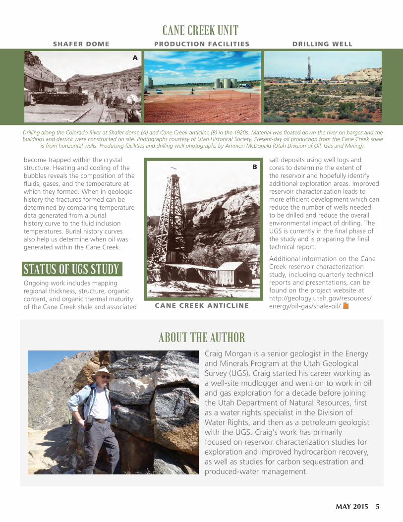
Drilling along the Colorado River at Shafer dome (A) and Cane Creek anticline (B) in the 1920s. Material was floated down the river on barges and the buildings and derrick were constructed on site. Photographs courtesy of Utah Historical Society. Present-day oil production from the Cane Creek shale
is from horizontal wells. Producing facilities and drilling well photographs by Ammon McDonald (Utah Division of Oil, Gas and Mining).
become trapped within the crystal structure. Heating and cooling of the bubbles reveals the composition of the fluids, gases, and the temperature at which they formed. When in geologic history the fractures formed can be determined by comparing temperature data generated from a burial history curve to the fluid inclusion temperatures. Burial history curves also help us determine when oil was generated within the Cane Creek.
STATUS OF UGS STUDYOngoing work includes mapping regional thickness, structure, organic content, and organic thermal maturity of the Cane Creek shale and associated
salt deposits using well logs and cores to determine the extent of the reservoir and hopefully identify additional exploration areas. Improved reservoir characterization leads to more efficient development which can reduce the number of wells needed to be drilled and reduce the overall environmental impact of drilling. The UGS is currently in the final phase of the study and is preparing the final technical report.
Additional information on the Cane Creek reservoir characterization study, including quarterly technical reports and presentations, can be found on the project website at http://geology.utah.gov/resources/energy/oil-gas/shale-oil/.
CANE CREEK UNITDRILLING WELLPRODUCTION FACILITIESSHAFER DOME
CANE CREEK ANTICLINE
ABOUT THE AUTHORCraig Morgan is a senior geologist in the Energy and Minerals Program at the Utah Geological Survey (UGS). Craig started his career working as a well-site mudlogger and went on to work in oil and gas exploration for a decade before joining the Utah Department of Natural Resources, first as a water rights specialist in the Division of Water Rights, and then as a petroleum geologist with the UGS. Craig’s work has primarily focused on reservoir characterization studies for exploration and improved hydrocarbon recovery, as well as studies for carbon sequestration and produced-water management.
A
B
MAY 2015 5

Phosphate Rock BasicsUtah hosts a long list of economically important industrial minerals, and phosphate rock is definitely on the list. Phosphate rock has over 100 years of history of Utah production, primarily for use in fertilizer. Phosphate is an important source of phosphorous, and should not be confused with potash, which is a source of potassium for fertilizer and is also produced in Utah. Phosphorous is one of the three essential plant nutrients, along with potassium and nitrogen, hence its use in fertilizer. Phosphate is also used to produce phosphoric acid and elemental phosphorous for a variety of industrial applications. According to the U.S. Geological Survey, China, the U.S., Morocco, and Western Sahara are currently the largest producers of phosphate rock. Most of the U.S. phosphate production comes from Florida and North Carolina, but Idaho and Utah are also producers. Significant sedimentary deposits of phosphate rock occur in Idaho, Utah, and, to a lesser degree, Wyoming and Montana. The quality of phosphate rock is most often expressed in P2O5 content, and some of the world’s richest phosphate rock deposits contain 30 percent P2O5 or better. Utah contains some of these rich deposits, but some of Utah’s lower-grade deposits are equally as important.
Utah’s Phosphate ResourcesUtah’s phosphate resources occur primarily in rocks deposited in an ocean basin that covered much of northern Utah during Permian time (over 250 million years ago). The Permian marine conditions were ripe for depositing the mineral apatite, or more specifically, carbonate-fluorapatite, which is the primary ore in the phosphate deposits of the western U.S. The exact conditions and mechanisms to precipitate the Permian apatite in the western U.S. are an ongoing source of study and discussion. The main geologic unit that hosts the phosphate deposits is the Meade Peak Member of the Phosphoria Formation, which is made up of dark-colored phosphorite (a rock composed primarily of apatite), mudstone, and carbonate. Structureless pellets and nodules, fossil fragments, oolites, and pisolites (oolites and pisolites are grains that exhibit concentric layering) often comprise and define the texture of the phosphorite of
Today’s (and Tomorrow’s?)
P H O S P H A T EB Y ANDREW RUPKE
the Meade Peak, and pelletal phosphorite is probably the most common. In northeastern Utah, the Phosphoria Formation commonly occurs as a tongue (or zone) within limestone, dolomite, and sandstone of the Permian Park City Formation (see map).
Where present, the Meade Peak Member ranges from very thin to about 225 feet thick. However, depending on the location, only part of that makes for an economic resource. Generally, only specific zones in the Meade Peak are high enough grade to be of economic interest, which is currently around 20 percent P2O5 or better, and the entire thickness of the Meade Peak generally averages considerably lower grade than that. A few attempts have been made to
define Utah’s phosphate resources, but the estimates vary widely due to differing assumptions and minimum grades. Suffice it to say, Utah has hundreds of millions of tons of in-place resources, but only a fraction of those resources are likely to be mined due to low grade, unfavorable deposit location, or mining configuration. However, expansion of current production appears likely due to depleted resources elsewhere and growing demand.
Production HistoryDetails vary, but most sources agree that phosphate in Utah was first discovered and produced in the late 1890s along Woodruff Creek, southwest of the town of Woodruff in Rich County. Only a small amount of phosphate rock was produced near Woodruff Creek, and in the early 1900s production shifted to the Crawford Mountains, also in Rich County. Production from the Crawfords was intermittent in the first half of the 20th century, but became more regular in the 1950s through the mid-1970s. The Crawford Mountains hold some of the highest grade (greater than 30 percent P2O5) phosphate deposits in Utah, but the complex geologic structure of the Meade Peak Member in the area required underground mining, which is substantially more expensive than shallow surface mining. Production from the Crawfords has been negligible since the late 1970s.
Currently, phosphate production in Utah comes from the southeast flank of the Uinta Mountains, north of Vernal in Uintah County. The San Francisco Chemical Company began production at the Vernal mine in 1961. The mine has had multiple owners, and J.R. Simplot
Surface outcrop of the Permian Phosphoria and Park City Formations in northeastern Utah.
6 SURVEY NOTES
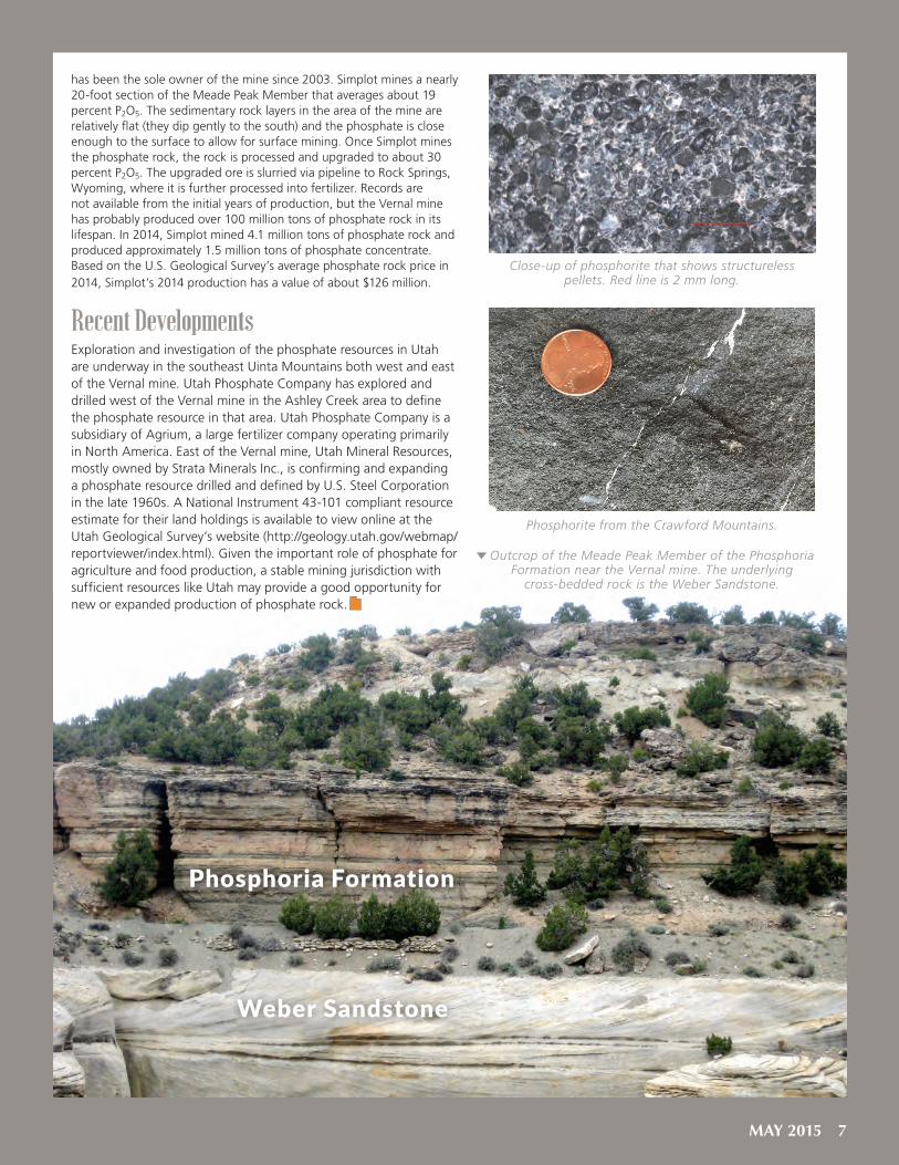
has been the sole owner of the mine since 2003. Simplot mines a nearly 20-foot section of the Meade Peak Member that averages about 19 percent P2O5. The sedimentary rock layers in the area of the mine are relatively flat (they dip gently to the south) and the phosphate is close enough to the surface to allow for surface mining. Once Simplot mines the phosphate rock, the rock is processed and upgraded to about 30 percent P2O5. The upgraded ore is slurried via pipeline to Rock Springs, Wyoming, where it is further processed into fertilizer. Records are not available from the initial years of production, but the Vernal mine has probably produced over 100 million tons of phosphate rock in its lifespan. In 2014, Simplot mined 4.1 million tons of phosphate rock and produced approximately 1.5 million tons of phosphate concentrate. Based on the U.S. Geological Survey’s average phosphate rock price in 2014, Simplot’s 2014 production has a value of about $126 million.
Recent DevelopmentsExploration and investigation of the phosphate resources in Utah are underway in the southeast Uinta Mountains both west and east of the Vernal mine. Utah Phosphate Company has explored and drilled west of the Vernal mine in the Ashley Creek area to define the phosphate resource in that area. Utah Phosphate Company is a subsidiary of Agrium, a large fertilizer company operating primarily in North America. East of the Vernal mine, Utah Mineral Resources, mostly owned by Strata Minerals Inc., is confirming and expanding a phosphate resource drilled and defined by U.S. Steel Corporation in the late 1960s. A National Instrument 43-101 compliant resource estimate for their land holdings is available to view online at the Utah Geological Survey’s website (http://geology.utah.gov/webmap/reportviewer/index.html). Given the important role of phosphate for agriculture and food production, a stable mining jurisdiction with sufficient resources like Utah may provide a good opportunity for new or expanded production of phosphate rock.
Phosphorite from the Crawford Mountains.
Close-up of phosphorite that shows structureless pellets. Red line is 2 mm long.
Outcrop of the Meade Peak Member of the Phosphoria Formation near the Vernal mine. The underlying
cross-bedded rock is the Weber Sandstone.
Phosphoria Formation
Weber Sandstone
MAY 2015 7

B Y MICHAEL D. VANDEN BERG
SKYLINE 16 GREEN RIVER FORMATION CORE:
WORLD CLASS LACUSTRINE TEACHING TOOL
his article is the second in a series of articles planned to highlight exceptional examples of the diverse
geologic cores available at the Utah Geological Survey’s (UGS) Utah Core Research Center (UCRC) (see Survey Notes, vol. 46, no. 3). As well as being used for research purposes, these cores, obtained through UGS projects and generous industry donations, are used for teaching geology students and training industry professionals, particularly those who search for oil and gas. Utah is fortunate in that many of the same rocks captured in subsurface cores housed in the UCRC collection are exposed in canyons, mountains, and plateaus throughout the state. Thus, geology groups and researchers often head to the field to get a broader view of the same rocks they examine at the UCRC. To assist, the UGS offers core workshops and associated field trips, using cores that showcase classic examples of Utah geology to enlighten bright young minds and train the working professional. The Skyline 16 Green River Formation lacustrine (lake) core is one of the most popular training resources at the UCRC.
The beautiful high desert landscape of the Uinta Basin looked very different 50 million years ago, during the Eocene Epoch. Imagine a landscape similar to present-day Great Salt Lake, but with a much larger lake, one that at times filled the entire Uinta Basin in Utah, as well as the Piceance Basin in western Colorado. The evidence for this large Eocene lake, named Lake Uinta, as well as a similar lake in Wyoming named Lake Gosiute, is recorded in the sediments of the Green River Formation. Utah’s much-talked-about oil shale resources, as well as significant conventional oil and gas reserves, are found within the strata that accumulated in ancient Lake Uinta. Additionally, recently discovered, massive, deep-water offshore Brazil (pre-salt) oil accumulations are interpreted to be in Lower Cretaceous lacustrine carbonates, including possible microbialites. Similar deep-water carbonate reservoirs have also been found off the west coast of Africa. To better understand these new discoveries, as well as other lacustrine oil
core centernews
reservoirs worldwide, geologic researchers have sought out well-known examples of lacustrine rocks, such as the Green River Formation.
In May 2010, the UGS and the University of Utah’s Institute for Clean and Secure Energy teamed up to recover 1000 feet of continuous 4-inch-diameter core from the middle to upper Green River Formation, about 60 miles southeast of Vernal in Uintah County. The core was subsequently slabbed lengthwise, taking care to provide an excellent, unobscured viewing surface. Additionally, the larger-than-typical core diameter allowed for an unusually large “slab” surface that
Vernal
Price
GrandJunction
Rifle
Rock Springs
Big Piney
Evanston GRE
EN R
IVER
BA
SIN
WASHAKIEBASIN
UINTABASIN PICEANCE
BASIN
Utah
Colorado
Wyoming
10 0 10 20 30
Miles
Skyline 16 Douglas C
reekA
rch
Uinta Mountain Uplift
Lake Uinta
Lake Gosiute
exhibits many of the core’s excellent lacustrine features.
The lower part of the core captured lithified sediments that were deposited near the shore of the ancient lake. Lake levels fluctuated significantly at this time, creating rapid changes in rock types, or facies, preserved in the core. Similar to Great Salt Lake, the nearshore part of Lake Uinta in eastern Utah was probably very flat and broad, meaning a small change in lake water elevation would greatly affect the lake’s overall size and facies distribution. The fluctuations are recorded as roughly 3-foot, shallowing-upward cycles. Often, the part of each cycle representing the
8 SURVEY NOTES

shallowest water contains beautifully preserved microbialites including stromatolites, thrombolites, and associated carbonate grains (ooids, pisoids, and oncolites). The extent and characteristics of the microbialite facies within the Green River Formation is particularly important as these rocks have some of the best petroleum reservoir qualities.
Moving stratigraphically higher in the core, the rocks record a gradual transition from nearshore, shallow water (littoral to sub-littoral) to offshore, much deeper water (profundal), and therefore a much larger lake. At a depth of about 460 feet, the core preserves the Mahogany bed. The sediments in this bed contain almost 40 percent preserved organic material, the highest found in the core. This interval of core is interpreted as preserving the lake’s highest level and largest aerial extent. This zone is also prized for containing the largest oil shale resource in the state of Utah.
Following Mahogany-zone time, the lake began to shrink, eventually retreating to a point where it became restricted and hypersaline. At this time, saline minerals began to precipitate in the lake’s bottom sediments and are now preserved in the core. This transformation is somewhat similar to how Pleistocene Lake Bonneville retreated and shrunk into present-day, hypersaline Great Salt Lake.
The Skyline 16 core provides an excellent teaching tool for researchers interested in lacustrine strata and reservoir systems. The entire range of lacustrine environments are preserved and excellently displayed in this core, from deep-lake, laminated, organic-rich oil shales, to shallow-water microbialites and associated carbonate grainstones, to fluvial, deltaic, and mouth-bar siliciclastics, to evaporite deposits. For the full lacustrine experience, UGS geologists can also arrange a trip to Great Salt Lake, which serves as an excellent modern analogue to features preserved in the core, or a trip to the world-class Green River Formation outcrops in the southeastern Uinta Basin.
To see the Skyline 16 Green River Formation core or schedule a workshop/field trip, contact Michael Vanden Berg, Petroleum Section Manager (801-538-5419, [email protected]) or Peter Nielsen, UCRC Curator (801-537-3359, [email protected]).
Shallowing-upward cycle found in the lower part of the Skyline 16 core.
Digitate stromatolites in the Skyline 16 core (972.8 ft).
The Mahogany bed, an organic-rich, thinly laminated oil shale, represents Lake Uinta’s
highest water level and greatest aerial extent.
SH
ALL
OW
ING
UP
WA
RD
CY
CLE
FLOODINGSURFACE
FLOODINGSURFACE
MICROBIALITES,CARBONATE
GRAINSTONES
ORGANIC-RICH,THINLY LAMINATEDCARBONATE MUD
MAY 2015 9

WHY ARE THERE UTAH NAMES O N M A R S ?
G la dYo u
AskedOn August 5, 2012, NASA’s Mars rover Curiosity landed on the “Red Planet” to begin its scientific mission to study the fascinating geology of the 96-mile-wide Gale Crater and search for evidence of ancient environments capable of supporting microbial life. Gale Crater was chosen for the landing site because water was most likely present during various times since a meteorite created it 3.5 to 3.8 billion years ago. So far Curiosity has traveled over 6 miles photographing the terrain and taking close-ups of outcrops or significant rocks, analyzing rock samples for chemical and mineral content, and determining atmospheric conditions, on its sojourn from the landing site and up the flank of Mount Sharp—a huge mountain rising from the crater floor that exposes sedimentary
(layered) rocks that are targeted for detailed study.
Periodically, the Curiosity science team compiles lists of potential names to use for rock targets and locations observed by Curiosity along
its trek. These informal names differ from the formal names for major features designated by the International Astronomical Union (IAU). The rover science team’s convention is to take names from Earth places and (ideally) geologic formations or features, and assign them to Mars features in each 1.5-kilometer quadrangle the rover drives through. The theme for the Shoshone quadrangle on Mars that the rover entered on June 23, 2014, was from the southwest United States. Utah’s spectacular cliffs, canyons, mountains, and world-famous rock formations have provided the Curiosity team with a plethora of names to use—nearly 40 applied to Curiosity sites and rocks to date. Many of these Utah names selected now show up on photos and descriptions on the mission website (http://mars.jpl.nasa.gov/msl/mission/overview/), blogs, press releases, etc. They will later appear in planetary journal papers and as parts of various scientific presentations.
Many of the Utah names now applied to Martian rocks, outcrops, and locations are very familiar to those of us from the state, or tourists and geologists who have visited the incredible geology at our many beautiful national and state parks. Some Mars features look very similar to Utah geosites or rocks, whereas others are similar in name only. The following are some examples from the
Mars Curiosity mission through Gale Crater, and their Utah namesakes.
Curiosity landing site within Gale Crater on Mars. The landing ellipse is 20 by 7 kilometers. Courtesy of NASA/JPL-Caltech/MSSS. Inset: NASA/ESA/Hubble.
BY Thomas C. Chidsey, Jr., Utah Geological Survey AND Rebecca M. E. Williams, Planetary Science Institute
10 SURVEY NOTES

The Pink CliffsThe Martian Pink Cliffs comprise a small ridge about 3 feet long and 6 inches high. This sandstone ridge appears more resistant to erosion than the surrounding flatter terrain. The rocks in this region are heavily fractured and sculpted by wind erosion. The rover team had Curiosity drill a test hole at this site.
In Utah, the Pink Cliffs are the top “step” in the Grand Staircase, a series of prominent,
east-west-trending cliffs which ascend from the rim of the Grand Canyon to the High Plateaus of southern Utah. The Pink Cliffs are composed of the Eocene-age (55 million years old) Claron Formation and consist of siltstone, sandstone, and conglomerate deposited in river, deltaic, and lake environments. Erosion has sculpted the Claron into the spectacular hoodoos at Bryce Canyon National Park and Cedar Breaks National Monument along the Pink Cliffs.
Location of four sites in Utah whose names are now used in Gale Crater on Mars.
The Pink Cliffs form the rim of Bryce Canyon National Park. Photo by Kent Brown, Utah Geological Survey.
Pink Cliffs, Mars. Sol (Mars day) 771, Mastcam mosaic acquired on October 7, 2014. Note: 2.5 cm = 1 inch.
Courtesy of NASA/JPL-Caltech/MSSS
MAY 2015 11
Whale RockWith its humpback form, Whale Rock is one of the more prominent outcrops in Mars’ Pahrump Hills region. This beautifully cross-bedded Martian sandstone has small “climbing” ripples, a sedimentary structure that forms in conditions of rapid deposition. These features possibly represent river-transported sediment that underwent rapid deceleration as it entered into a lake basin, creating a delta deposit. Cross-beds are key paleoflow-direction indicators, and at Whale Rock the current direction was to the southeast (left in image).
Utah’s Whale Rock is located in the Island in the Sky district of Canyonlands National Park. It is a large, eroded and rounded outcrop of Jurassic-age (about 190 million years old) Navajo Sandstone (composed of wind dune sands deposited in an ancient Sahara-like desert) that looks like, as its name suggests, a large whale. Cross-beds indicate paleowind directions were from the north and north-northwest.
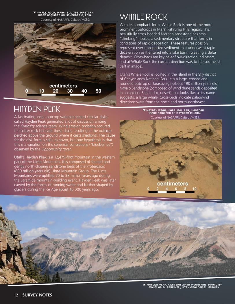
Hayden PeakA fascinating ledge outcrop with connected circular disks called Hayden Peak generated a lot of discussion among the Curiosity science team. Wind erosion probably scoured the softer rock beneath these discs, resulting in the outcrop perched above the ground where it casts shadows. The cause for the disk form is still unknown, but one hypothesis is that this is a variation on the spherical concretions (“blueberries”) observed by the Opportunity rover.
Utah’s Hayden Peak is a 12,479-foot mountain in the western part of the Uinta Mountains. It is composed of faulted and gently north-dipping sandstone beds of the Proterozoic (800 million years old) Uinta Mountain Group. The Uinta Mountains were uplifted 70 to 38 million years ago during the Laramide mountain-building event. Hayden Peak was later carved by the forces of running water and further shaped by glaciers during the Ice Age about 16,000 years ago.
Whale Rock, Mars. Sol 796, Mastcam image acquired on November 2, 2014.
Courtesy of NASA/JPL-Caltech/MSSS.
Hayden Peak, Mars. Sol 785, Mastcam image acquired on October 21, 2014.
Courtesy of NASA/JPL-Caltech/MSSS.
Hayden Peak, western Uinta Mountains. Photo by Douglas A. Sprinkel, Utah Geological Survey.
12 SURVEY NOTES
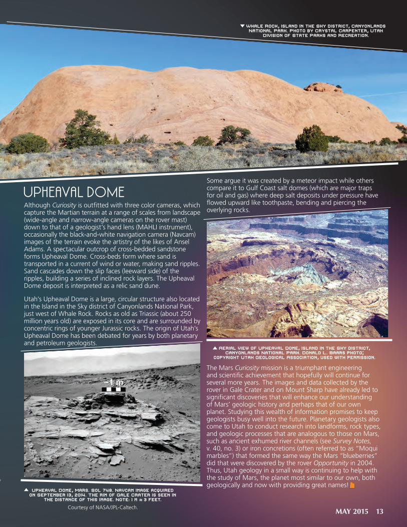
Upheaval DomeAlthough Curiosity is outfitted with three color cameras, which capture the Martian terrain at a range of scales from landscape (wide-angle and narrow-angle cameras on the rover mast) down to that of a geologist’s hand lens (MAHLI instrument), occasionally the black-and-white navigation camera (Navcam) images of the terrain evoke the artistry of the likes of Ansel Adams. A spectacular outcrop of cross-bedded sandstone forms Upheaval Dome. Cross-beds form where sand is transported in a current of wind or water, making sand ripples. Sand cascades down the slip faces (leeward side) of the ripples, building a series of inclined rock layers. The Upheaval Dome deposit is interpreted as a relic sand dune.
Utah’s Upheaval Dome is a large, circular structure also located in the Island in the Sky district of Canyonlands National Park, just west of Whale Rock. Rocks as old as Triassic (about 250 million years old) are exposed in its core and are surrounded by concentric rings of younger Jurassic rocks. The origin of Utah’s Upheaval Dome has been debated for years by both planetary and petroleum geologists.
Some argue it was created by a meteor impact while others compare it to Gulf Coast salt domes (which are major traps for oil and gas) where deep salt deposits under pressure have flowed upward like toothpaste, bending and piercing the overlying rocks.
The Mars Curiosity mission is a triumphant engineering and scientific achievement that hopefully will continue for several more years. The images and data collected by the rover in Gale Crater and on Mount Sharp have already led to significant discoveries that will enhance our understanding of Mars’ geologic history and perhaps that of our own planet. Studying this wealth of information promises to keep geologists busy well into the future. Planetary geologists also come to Utah to conduct research into landforms, rock types, and geologic processes that are analogous to those on Mars, such as ancient exhumed river channels (see Survey Notes, v. 40, no. 3) or iron concretions (often referred to as “Moqui marbles”) that formed the same way the Mars “blueberries” did that were discovered by the rover Opportunity in 2004. Thus, Utah geology in a small way is continuing to help with the study of Mars, the planet most similar to our own, both geologically and now with providing great names!
Upheaval Dome, Mars. Sol 748, Navcam image acquired on September 13, 2014. The rim of Gale Crater is seen in
the distance of this image. Note: 1 m ≈ 3 feet.
Courtesy of NASA/JPL-Caltech.
Whale Rock, Island in the Sky district, Canyonlands National Park. Photo by Crystal Carpenter, Utah
Division of State Parks and Recreation.
Aerial view of Upheaval Dome, Island in the Sky district, Canyonlands National Park. Donald L. Baars photo;
copyright Utah Geological Association, used with permission.
MAY 2015 13

Deseret Limestone
Morgan Form
ation
& Round Valley
Limestone
Weber Sandstone
formation of Hades Pass
Sheep Creek Canyon Geological Area (SCCGA) is a scenic locale depicting almost 800 million years of geologic history, situated on the north flank of the eastern Uinta Mountains just west of Flaming Gorge National Recreation Area. Drive the loop road through the geological area to see stunning views, spectacular cliffs, dramatically tilted and folded rock layers, and the Rocky Mountain bighorn sheep for which the creek is named. Signs along the road within SCCGA point out the different geologic rock formations.
GEOLOGIC HISTORYThe oldest rocks of SCCGA were deposited in an ancient basin around 770 million years ago, first in streams, then in both non-marine and marine environments indicative of an encroaching sea. Strata representing the subsequent 410 million years are missing (unconformity). Either these rocks were never deposited or were eroded away before the geological area’s next rock formation was deposited, but regional evidence suggests that this area was at or above sea level during this time.
Seas flooded this region approximately 350 million years ago, and for 65 million years shallow marine and coastal sediments were deposited until the seas completely withdrew and an eolian (wind-blown) sand environment dominated. Succeeding the sand dunes, the youngest rock formations in SCCGA were deposited in marine environments that were separated in time by a sea-level drop and a 10-million-year unconformity.
Rocks younger than 245 million years old have been eroded from SCCGA, but are preserved just north of the geological area’s boundary. These rocks reveal that deposition of marine and non-marine sediments continued until about 70 million years ago when the area began to rise during the Laramide orogeny, causing the seas to retreat forever and the Uinta Mountains to form. During this time of mountain building
BY CHRISTINE WILKERSON
Sheep Creek Canyon Geological Area, Daggett County
Tower Rock stands amid tall cliffs lining both sides of the canyon. These sandstone rocks were once ancient sand dunes. Photo by
Douglas A. Sprinkel, Utah Geological Survey.
View to the northwest from the Sheep Creek Canyon Geological Area overlook. Dashed line is fault. Photo by Douglas A. Sprinkel.
14 SURVEY NOTES

(70 to 40 million years ago), the rocks in SCCGA were uplifted, eroded, faulted, folded, and tilted steeply northward.
Geologically recent deposits in SCCGA include sediments and rock debris from landslides, debris flows, rivers and streams, and talus.
GEOLOGIC SITES
As you travel through SCCGA, you will see many interesting geological features. Three main geologic sites along the loop road are highlighted in this article: Sheep Creek Canyon overlook, Palisades Memorial Park, and Tower Rock.
The Sheep Creek Canyon overlook, at the southern boundary of the geological area, presents a panoramic view of the strata and structure of SCCGA. From the viewpoint you can see the red rocks of the 770-million-year-old formation of Hades Pass that were emplaced against the much younger gray rocks of Deseret Limestone (about 350 million years old) by a fault during uplift of the Uinta Mountains. These strata were also folded and tilted during that time. The Deseret Limestone cliff is known as The Palisades.
Palisades Memorial Park provides a sobering reminder of potential dangers associated with geologic processes, in this case a rainstorm-triggered debris flow. During the stormy night of June 9, 1965, seven family members perished when a devastating debris flow swept down Sheep Creek and through their camp, destroying their trailer and the Palisades campground. The debris flow originated about a mile upstream, likely where Sheep Creek undercut part of a large landslide causing rocks and soil to slump into the creek. This debris and other
material scoured from the channel banks along the way were carried rapidly downstream, probably arriving at the campground only a few minutes later. After this tragic event, the U.S. Forest Service designated the old campground site as Palisades Memorial Park and restricted its use to daytime only. A bouldery debris-flow levee is preserved west of the picnic area and contains some misshapen water pipes and other metal from the campground.
Tower Rock, in the northeastern section of SCCGA, is a hoodoo rock formation that resembles a tower constructed against the steep cliffs that rise alongside the loop road. A hoodoo is a rock pillar that has been carved into a fantastic or eccentric shape by different rates of weathering and erosion of different parts of the pillar due to variations in the rock’s resistance. Tower Rock is composed of Weber Sandstone, and the large-scale cross-bedding and well-sorted quartz sand grains indicate that this sandstone was originally wind-blown sand dunes. These ancient dunes accumulated around 285 million years ago during Early Permian time.
For more information on Sheep Creek Canyon Geological Area, see the article by D. Sprinkel, B. Park, and M. Stevens in Geology of Utah’s Parks and Monuments (Utah Geological Association Publication 28).
The loop road through SCCGA extends for 13 miles on U.S. Forest Service (USFS) Road 218. This road is closed in winter.
From the North – After driving into the town of Manila on Utah Highway 43, turn south onto Main Street/Utah Highway 44 and continue for almost 6 miles to the intersection with USFS Road 218, which marks the northern starting point of the loop road. Turn right (west) onto USFS Road 218 and drive 3 miles to SCCGA.
From the South – From Main Street in Vernal, turn north onto Vernal Avenue/U.S. Highway 191 and after about 35 miles continue driving straight as the road name changes to Utah Highway 44 (do not continue on U.S. Highway 191, which makes a sharp right turn here). Continue traveling for almost 14.5 miles to the intersection with USFS Road 218, which marks the southern starting point of the loop road. Turn left (west) onto USFS Road 218 and drive approximately 6.5 miles to SCCGA.
HOW TO GET THERE
Geologic column of rock formations and Quaternary deposits in Sheep Creek Canyon Geological Area (modified from Sprinkel and others, 2010,
in Utah Geological Association Publication 28). Numbers in "ERA" column indicate millions of years ago.
ERA FORMATIONS &
QUATERNARY DEPOSITS
LITHOLOGY(column not to scale)
CENO
ZOIC
alluvium
alluvial-fan deposits
colluvium
debris-flow deposits
talus deposits
landslide deposits
MES
OZOI
C
Dinwoody Formation
PALE
OZOI
C
Park City & Phosphoria Formations
Weber Sandstone
Morgan Formation
Round Valley Limestone
Doughnut Shale
Humbug Formation
Deseret & Madison Limestones
NEOP
ROTE
ROZO
IC
Uint
a M
ount
ain
Grou
p (p
art)
upper formation
of Hades Pass
lower formation
of Hades Pass
debris flow killed 7 people camped at Palisades Campground (now picnic area) on June 9, 1965
apline glaciers in Uinta Mountains (latest episode 30–12 thousand years ago); capture of Green River by the Colorado River system within the last 2 million years
Uinta Mountains are uplifted between about 70 to 40 million years ago. Much of the rocks of Mesozoic age are eroded off the rising highlands. About 30 million years ago, the Uinta Mountains began to collapse as erosion continues
TR-1 unconformity ~10 m.y.
unconformity ~410 m.y.
phosphate deposits
forms massive-weathering cliffs in the northern part of the canyon; forms Tower Rock
forms ledges, contains marine fossils
forms cliffs locally called The Palisades; Big Spring issues from the Deseret; contains marine fossils
forms the core of the Uinta Mountains; contains marine and non-marine beds deposited in fault basin
unconformity 3 m.y.
2.6245
251260
359770
MAY 2015 15

2014 Employee of the Year | PAM PERRI
AAPG DEG 2014 Award | BEST POSTER
Congratulations to Pam Perri who was named the 2014 UGS Employee of the Year. Pam is an Office Specialist in the Geologic Hazards Program and has worked for the UGS for three years. Pam is an outstanding employee who brings a high degree of energy, skill, commitment, and professional conduct to her job. She typically goes above and beyond what is required to get the job done, and is quick to volunteer whenever help is needed. Pam has a friendly demeanor and positive attitude that is contagious. We are proud to recognize Pam for her outstanding contributions to the UGS.
Dave Tabet and Tom Chidsey were selected as the recipients of the American Association of Petroleum Geologists (AAPG) Division of Environmental Geosciences (DEG) Excellence of Presentation Award, Best Poster for their paper Basin-Scale Analysis, Management Tools, and Options for Produced Water From Tight-Gas Sand Reservoirs, Uinta Basin, Utah, presented last year during the AAPG’s annual convention in Houston, Texas. Nikki Simon designed the poster. See Survey Notes, v. 45, no. 1, for details about the Uinta Basin produced water project or view the poster online at geology.utah.gov/emp/UBproduced_water/pdf/UBproduced_water_poster_aapg2014.pdf.
NEW UGS BOARD MEMBERSWe are pleased to welcome three new UGS Board members. They were appointed by Governor Herbert and confirmed by the Senate during this year’s legislative session. The new members are Ken Fleck, representing coal mining, Sam Quigley, representing industrial minerals, and Elissa Richards, representing the public-at-large. They began serving their terms on April 1, 2015. Terms have expired for Mark Bunnell, Ken Puchlik, and Sunny Dent. They have served us well as members of the UGS Board, and we thank them for their efforts.
Andy Cvar joins the Natural Resources Map & Bookstore as an accounting technician. He is an avid hiker and spends much of his free time, camera in hand, enjoying Utah’s scenic outdoors.
16 SURVEY NOTES
Baseline Hydrology of Ashley Spring, by Paul Inkenbrandt, Janae Wallace, and Melissa Hendrickson, CD (54 p.), ISBN 978-1-55791-908-3, Special Study 154..........$14.95
Surface fault rupture hazard maps of the Levan and Fayette segments of the Wasatch fault zone, Juab and Sanpete Counties, Utah, by Adam I. Hiscock and Michael D. Hylland, CD (7 plates), scale 1:24,000, Open-File Report 640..........$14.95
Geologic map of unconsolidated deposits in the Hogup Bar quadrangle, Box Elder County, Utah, by Daren T. Nelson and Paul W. Jewell, CD (12 p., 1 pl. [contains GIS data]), scale 1:24,000, ISBN 978-1-55791-906-9, Miscellaneous Publication 15-2DM....$19.95
Surface fault rupture hazard map of the Honeyville quadrangle, Box Elder and Cache Counties, Utah, by Kimm M. Harty and Adam P. McKean, CD (1 plate), scale 1:24,000, Open-File Report 638.........$14.95
Geologic map of the Santa Clara quadrangle, Washington County, Utah, by Grant C. Willis and Janice M. Hayden, CD (21 p., 2 pl. [contains GIS data]), ISBN 978-1-55791-905-2, scale 1:24,000, Map 271DM.........$24.95
Cache Valley aquifer storage and recovery—site assessment for Millville City, Cache County, Utah, by Paul Inkenbrandt, CD (29 p.), Open-File Report 636......$14.95
NEW PUBLICATIONS
This seven-year, hydrogeologic study to monitor groundwater in Utah’s Snake Valley was recently released by the Utah Geological Survey. The report presents hydrogeologic, groundwater-monitoring, and hydrochemical studies in Snake Valley, Tule Valley, and Fish Springs Flat in Millard and Juab Counties, west-central Utah. Data from the newly established UGS groundwater-monitoring network establishes current baseline conditions, and will help quantify the effects of future variations in climate and groundwater pumping. New hydrochemical data show that groundwater quality is generally good, major-solute chemistry varies systematically from recharge to discharge areas, and suggest that most groundwater was recharged over one thousand years ago, implying low recharge rates and/or long or slow flow paths. Two aquifer tests yield estimates of transmissivity and storativity for the carbonate-rock and basin-fill aquifers. Variations in the potentiometric surface, hydrogeology, and hydrochemistry are consistent with the hypothesis of regional groundwater flow from Snake Valley northeast to Tule Valley and Fish Springs. Collectively, the work delineates groundwater levels, flow, and chemistry in Snake Valley and adjacent basins to a much greater degree than previously possible, and emphasizes the sensitivity of the groundwater system to possible increases in groundwater pumping. The report is available for purchase from the Natural Resources Map & Bookstore.
compiled by Hugh Hurlow, DVD (269 p., 4 pl.), ISBN 978-1-55791-902-1, Bulletin 135....$24.95
HYDROGEOLOGIC STUDIES AND GROUNDWATER MONITORING IN SNAKE VALLEY AND ADJACENT HYDROGRAPHIC AREAS, WEST-CENTRAL UTAH AND EAST-CENTRAL NEVADA
BULLETIN 135UTAH GEOLOGICAL SURVEYa division ofUTAH DEPARTMENT OF NATURAL RESOURCES2014
Compiled by Hugh Hurlow
Contributing Authors – Hugh Hurlow, Stefan Kirby, J. Lucy Jordan, Paul Inkenbrandt, Janae Wallace, Mike Lowe, Kevin Thomas, and Walid Sabbah
HYDROGEOLOGIC STUDIES AND GROUNDWATER MONITORING IN SNAKE VALLEY AND ADJACENT HYDROPGRAPHIC AREAS, WEST-CENTRAL UTAH
AND EAST-CENTRAL NEVADA
MAY 2015 17

FO LLOW US!
PRSRT STD U.S. Postage
PAID Salt Lake City, UT Permit No. 4728
UTAH GEOLOGICAL SURVEY 1594 W North Temple, Suite 3110 PO Box 146100 Salt Lake City, UT 84114-6100
Address service requested Survey Notes
Mon–Fri 8AM–5PM | 801-537-3320 OR 1-888-UTAHMAP | [email protected]
Natural Resources Map & Bookstore
1594 W North Temple Salt Lake City, UT 84116|
UGS Blog geology.utah.gov/blog UGS TwitterUGS Facebook
A wide variety of USGS 1:100,000-scale topographic maps from 39 Midwestern,
Southern, and Eastern states are now on sale.
These are out-of-print 30’ x 60’ quadrangles showing:
Come browse through the large selection of maps available now at the Department of Natural Resources Map & Bookstore.
Call or email to inquire about availability of specific maps.
/ Contours and elevations in meters
/ Highways, roads, and other manmade structures
/ Water features
/ Woodland areas
/ Geographic names
We've got you covered inside Utah, and out.
US GS M AP S A LEO N LY $1 WHILE TH E Y L A S T!