using the military lensatic compasslandnavigation.weebly.com/uploads/1/1/8/3/11832951/... · ·...
TRANSCRIPT

USING THE
MILITARY
LENSATIC
COMPASS
PART 3 Advance Land Navigation Module 17 Additional Land Navigation Skills

This presentation is intended as a
quick summary, and not a
comprehensive resource. If you
want to learn Land Navigation in
detail, either buy a book; or get
someone, who has the knowledge
and skills, to teach you in person.
WARNINGPART 3 Advance Land Navigation Module 17 Additional Land Navigation Skills
NOTEPART 3 Advance Land Navigation Module 17 Additional Land Navigation Skills
To get the ideas across presented on
these slides, many figures, pictures,
and calculations may not be to scale
and may be exaggerated for clarity.

Note:
Prior to being issued any training *equipment, you will
be required to sign a “statement of liability” agreeing
to pay for anything you damage or lose.
All items will be inspected and inventoried prior to
your signature and at the end of the training day too.
If you do not intend to sign this statement, then you
may be denied training.
* You may use your own equipment.
PART 3 Advance Land Navigation Module 17 Additional Land Navigation Skills

Any Questions?
PART 3 Advance Land Navigation Module 17 Additional Land Navigation Skills

LAND NAVIGATION
PRESENTATION
PART 3
Module 17
Additional Skills
PART 3 Advance Land Navigation Module 17 Additional Land Navigation Skills
PRESENTATION
. . . and now on with the . . .
PART 3 Advance Land Navigation Module 17 Additional Land Navigation Skills

LAND NAVIGATION WITH MAP
AND LENSATIC COMPASS
PART 3 Advance Land Navigation Module 17 Additional Land Navigation Skills

LAND NAVIGATIONWhy Learn Land Navigation?
- Tracking present location
- Determining Distance
- Sense of direction
- How to read a topographic map
-Terrain and map association
- Spatial skills
- Planning safe, practical routes
- And more Navigational skills
The best way to learn LAND NAVIGATION is to get "dirt time", that is, get out there with a map and compass!
Navigation is not about finding yourself after you are lost (although that’s what happens sometimes); it’s about
keeping track of your position as you move away from a known point. As you move you have to remain
cognizant of the terrain you are leaving, of the terrain you are passing, and of the terrain that is ahead.
Navigation in the wilderness means knowing your starting point, your destination, and your route to get there.
These skills will allow you to venture farther off the beaten path than you ever thought before.
(Where am I ?)
(How far is it and am I there yet ?)
(Where do I want to go and where am I actually going ?)
(Do I understand the map ?)
(What hill or river am I looking at ?)
(Can I mentally visualize the landscape in 3D ?)
(Take a long safe route or a short risky route ?)
Training and practicing land navigation on foot
provides the following everyday navigation (how not to get lost) benefits;
PART 3 Advance Land Navigation Module 17 Additional Land Navigation Skills

THIS PRESENTATION IS DIVIDED INTO FOUR PARTS________________________________________________________________________________________________________________________________________________________
PART 1 Basic Land Navigation
The Lensatic Compass module 1
The Topographic Map modules 2, 3, 4,
The Land and Map Association modules 5, 6
PART 2 Intermediate Land Navigation
Making Sense of Direction module 7
Tracking Present Location modules 8, 9, 10, 11
Determining Travel Distance modules 12, 13, 14
PART 3 Advance Land Navigation
Planning to Navigate module 15
Navigation Methods to Stay On Course module 16
Additional Skills of Land Navigation module 17
PART 4 Expert Land Navigation
Navigation in different types of Terrain module 18
Night Navigation module 19
Sustainment module 20
PART 3 Advance Land Navigation Module 17 Additional Land Navigation Skills

THESE ARE THE TRAINING MODULESModule 1 Lensatic Compass – parts and features, and how to sight the compass by two different methods.
Module 2 Topo Map Margin – what map margin data represents, map care, and how to properly fold a map.
Module 3 Topo Map Scale – map sizes and how it affects amount of detail that will be shown.
Module 4 Topo Map Symbols – you must understand them; to read and speak map language to others.
Module 5 Terrain Relief – shows elevation, indicates terrain features and heights of natural features.
Module 6 Map Information – what a protractor is for and how a map provides four kinds of information.
Module 7 Sense of Direction – lateral drift, current bearing, obstacles, back azimuth, deliberate offset.
Module 8 Resection – locate position with map only. Modified resection is with a map or compass.
Module 9 Intersection & Triangulation – two methods to locate position by compass.
Module 10 Map Speaks Compass Language - there is no need to orient the map to find your position.
Module 11 Plotting Position Coordinates – exact positioning, used to communicate to others with a map.
Module 12 Route Measure – mapping straight-line distance, curvature distance, and slope distance.
Module 13 Pace Count – using ranger pacing beads and estimating hiking speed.
Module 14 Travel Distance Estimation – estimating by 100 meter rule, rule-of-thumb, and by time.
Module 15 Plan to Navigate – in a group or alone, equipment, safety, responsibilities, route selection.
Module 16 Stay on Course – advance reference points and advance baselines.
Module 17 Additional Land Navigation Skills – estimate daylight, conserve energy, blisters, weather insight.
Module 18 Navigating Different Terrain – special environments, featureless terrain, visibility, dense foilage.
Module 19 Night Navigation – night adaptation, protecting night vision, navigate with lensatic compass.
Module 20 Sustainment – maintaining skills, training others, setting up a land navigation course.
PART 3 Advance Land Navigation Module 17 Additional Land Navigation Skills

Any Questions?
PART 3 Advance Land Navigation Module 17 Additional Land Navigation Skills

PART 3
ADVANCE LAND NAVIGATIONMODULE 17
• Additional Navigation Skills– Description
– Additional Skills
PART 3 Advance Land Navigation Module 17 Additional Land Navigation Skills
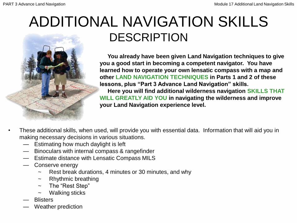
ADDITIONAL NAVIGATION SKILLSDESCRIPTION
You already have been given Land Navigation techniques to give
you a good start in becoming a competent navigator. You have
learned how to operate your own lensatic compass with a map and
other LAND NAVIGATION TECHNIQUES in Parts 1 and 2 of these
lessons, plus “Part 3 Advance Land Navigation” skills.
Here you will find additional wilderness navigation SKILLS THAT
WILL GREATLY AID YOU in navigating the wilderness and improve
your Land Navigation experience level.
• These additional skills, when used, will provide you with essential data. Information that will aid you in
making necessary decisions in various situations.
— Estimating how much daylight is left
— Binoculars with internal compass & rangefinder
— Estimate distance with Lensatic Compass MILS
— Conserve energy
~ Rest break durations, 4 minutes or 30 minutes, and why
~ Rhythmic breathing
~ The ―Rest Step‖
~ Walking sticks
— Blisters
— Weather prediction
PART 3 Advance Land Navigation Module 17 Additional Land Navigation Skills
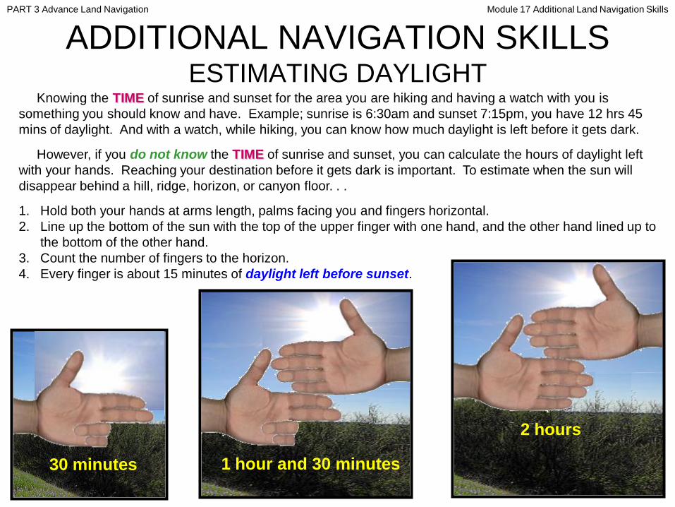
ADDITIONAL NAVIGATION SKILLSESTIMATING DAYLIGHT
Knowing the TIME of sunrise and sunset for the area you are hiking and having a watch with you is
something you should know and have. Example; sunrise is 6:30am and sunset 7:15pm, you have 12 hrs 45
mins of daylight. And with a watch, while hiking, you can know how much daylight is left before it gets dark.
However, if you do not know the TIME of sunrise and sunset, you can calculate the hours of daylight left
with your hands. Reaching your destination before it gets dark is important. To estimate when the sun will
disappear behind a hill, ridge, horizon, or canyon floor. . .
1. Hold both your hands at arms length, palms facing you and fingers horizontal.
2. Line up the bottom of the sun with the top of the upper finger with one hand, and the other hand lined up to
the bottom of the other hand.
3. Count the number of fingers to the horizon.
4. Every finger is about 15 minutes of daylight left before sunset.
30 minutes 1 hour and 30 minutes
2 hours
PART 3 Advance Land Navigation Module 17 Additional Land Navigation Skills

Any Questions?
PART 3 Advance Land Navigation Module 17 Additional Land Navigation Skills

ADDITIONAL NAVIGATION SKILLSBINOCULARS WITH COMPASS & RANGEFINDER
• This item is a luxury, BUT is a very useful luxury.
• The compass alone is a quick way to find An azimuth from a very far away distant landmark.
• The range finder is very easy to use and the data received from its use is invaluable.
PART 3 Advance Land Navigation Module 17 Additional Land Navigation Skills

ADDITIONAL NAVIGATION SKILLSBINOCULARS WITH COMPASS & RANGEFINDER
IMPORTANT: Always remember that the
Distance and Object Size scales are in a ―ratio‖
to each other. When you add ―0’s‖ to one, you
must add an equal number of ―0’s‖ to the other.
...
PART 3 Advance Land Navigation Module 17 Additional Land Navigation Skills

ADDITIONAL NAVIGATION SKILLSBINOCULARS WITH COMPASS & RANGEFINDER
When the object size is known, its distance is determined as follows:
1. Look through your binocular and place the horizontal reticle line at the base of the object.
2. Count the number of reticle divisions from the base to the top of the object. (In the example on the
previous slide, the top of the lighthouse comes to 2.5 on the Reticle Scale)
3. Rotate the Calculator Dial and place this number (2.5) at the Angle Index Mark
4. Assuming you know that the height of the lighthouse is 100 ft., look to the right of the Angle Index Mark
and find the object size on the scale labeled ―Object Size‖. In this example, use ―10‖.
NOTE
The object size divisions are from 1 to 20. In dealing with an object that is
100 feet, mentally add a zero to the 10 indicator on the object size scale.
5. Now read the distance scale directly beneath the object size. It is 400 but remember, because you added
a ―0‖ to the ―10‖ in Step 4, you must add a zero to the 400. Thus, the distance from you to the lighthouse
is 4000 feet.
When distance to the object is known, its size is determined as follows:
1. Count the reticle divisions occupied by the object
2. Rotate the Calculator Dial, so that the Angle Index Mark points to the number from the reticle scale .
3. Look at the Distance Scale, and find your known distance to the object (for example, 4000 feet, or 400 on
the scale). The number on the Object Size scale that is opposite this distance indicates the size of the
object (for example, 100 feet).
PART 3 Advance Land Navigation Module 17 Additional Land Navigation Skills

ADDITIONAL NAVIGATION SKILLSBINOCULARS WITH COMPASS & RANGEFINDER
( Using binocular ring calculator )• Map indicates Landmark is 100 yards wide.
• Landmark covers 4 marks on binocular scale.
• You are 1000 yards away from landmark.
• At your current speed, 30-40 minutes away.
• Both hikers are about 5’4‖ tall.
• Hiker covers 1½ (1.5) marks on binocular scale.
• Hikers are 950 feet (316 yards) away from camp.
• 10-15 minutes before they reach camp.
NOTE
drawings and
binocular dial
numbers are
exaggerated
for clarity.
Follow the
binocular
dinstruction
manual.
. .2 3 4 5 6
. .
.
PART 3 Advance Land Navigation Module 17 Additional Land Navigation Skills

Each tick
mark is 5mils
10mils 5mils
ADDITIONAL NAVIGATION SKILLSBINOCULARS WITH COMPASS & RANGEFINDER
( Using binocular tick mark MILS and formula )
Landmark is 92 meters (100yds) Width
binocular total tick mils is 40mils
92W 40m = 2.3 x 1000 meters = 2300 meters (2.3Km or 1½ miles)..
Heig
ht
Width
W (H)
R
m
• m is the angular width (height) of the object in MILS.
• W (H) is the width (height) of the object in meters.
• R is the range or distance in thousands of meters.
W (H)
R
• Range (distance) = W m
• Width = R x m
• m =
..
PART 3 Advance Land Navigation Module 17 Additional Land Navigation Skills

Any Questions?
PART 3 Advance Land Navigation Module 17 Additional Land Navigation Skills

ADDITIONAL NAVIGATION SKILLSESTIMATING DISTANCE WITH COMPASS MILS
5200mils 5300mils
Landmark is 92 meters (100yds) Width
Azimuth of the left side of landmark is 5200mils
Azimuth of the right side of landmark is 5300mils
Compass mils is 5300 – 5200 = 100mils
92 100 = 0.92 x 1000 meters = 920m (1,006yds)..
W (H)
R
m
• m is the angular width (height) of the object in MILS.
• W (H) is the width (height) of the object in meters.
• R is the range or distance in thousands of meters.
W (H)
R
• Range (distance) = W m
• Width = R x m
• m =
..
PART 3 Advance Land Navigation Module 17 Additional Land Navigation Skills
Any Questions?
PART 3 Advance Land Navigation Module 17 Additional Land Navigation Skills

d = ((Tan (90 - (A -B))) x Ref )
80 degrees A = Greater value of measured bearing angles
75 degrees B = Lower value of measured bearing angles
11.430 (85 deg) Tan = Tangent value (of the resultant angle)
100 meters Ref = Measured reference distance
1143 meters d = Distance (to be calculated)
1143 meters (1.1 Km) = ((11.430 (90 – (80 – 75))) x 100 meters)
This technique is good to use when you DO NOT HAVE A MAP. A Lensatic Compass is the best type of compass to use, it is easy to sight a landmark and is accurate.
1. You see a far away hill that you want to know the distance to, so you take a bearing reading to a spot on the hill. (Example 75 degrees)
2. You then walk perpendicular (right angle) to a measured distance. (Example 100 meters)
3. Then take another bearing reading to the exact same spot on the hill. (Example 80 degrees)
4. Next find degree difference and use the calculation to get the distance to the hill.
75 degrees
HILL
80 degrees
100 meters
Note: When you have a degree that reads less that 360 and the other more that 360 (0 degrees), example
358 degrees and 3 degrees, all you are looking for is the degree difference, just like the above example.
3 + 360 = 363, so you subtract 363 – 358 = 5. Tangent would be the same as above; 90 – 5 = 85 so the
Tangent is Tan = 11.430 (85 deg).
Deg Tangent Deg Tangent Deg Tangent
1 0.017 31 0.601 61 1.804
2 0.035 32 0.625 62 1.881
3 0.052 33 0.649 63 1.963
4 0.070 34 0.675 64 2.060
5 0.087 35 0.700 65 2.145
6 0.105 36 0.727 66 2.246
7 0.123 37 0.754 67 2.356
8 0.141 38 0.781 68 2.475
9 0.158 39 0.810 69 2.605
10 0.176 40 0.839 70 2.747
11 0.194 41 0.869 71 2.904
12 0.213 42 0.900 72 3.078
13 0.231 43 0.933 73 3.271
14 0.249 44 0.966 74 3.487
15 0.268 45 1 75 3.732
16 0.287 46 1.036 76 4.011
17 0.306 47 1.072 77 4.331
18 0.325 48 1.111 78 4.705
19 0.344 49 1.150 79 5.145
20 0.364 50 1.192 80 5.671
21 0.384 51 1.235 81 6.314
22 0.404 52 1.280 82 7.115
23 0.424 53 1.327 83 8.144
24 0.445 54 1.376 84 9.514
25 0.466 55 1.428 85 11.430
26 0.488 56 1.483 86 14.301
27 0.510 57 1.540 87 19.081
28 0.532 58 1.600 88 28.636
29 0.554 59 1.664 89 57.290
30 0.577 60 1.732 90
ADDITIONAL NAVIGATION SKILLSESTIMATING DISTANCE WITH COMPASS DEGREES
d = ((Tan (90 - (A -B))) x Ref )
1. (A – B) 80 – 75 = 5
2. (90 - (A-B)) 90 – 5 = 85 Deg
3. View chart and find 85 Deg to locate
Tangent. 11.430
4. (Tangent x Ref) 11.430 x 100 = 1143
5. d = 1,143 meters (1.1 Km)
PART 3 Advance Land Navigation Module 17 Additional Land Navigation Skills

THIS TECHNIQUE IS A SIMPLIFIED VERSION OF THE PREVIOUS SLIDE.
NOTE: You can use any degree that is at least 1 degree or more.
1. You see a far away hill that you want to know the distance to, so you take a bearing reading to a spot on the hill.
2. You then walk perpendicular (right angle) till you reach an off-set of at least 1 degree. (This example is 2 degrees)
NOTE: The further the landmark, the more distanced walked is needed to get a minimum of 1 degree difference
and the closer the landmark, the less distance walked is needed.
3. Then measure the distance walked from start to finish. (This example is 18 meters)
NOTE: you can use centimeters, meters, feet, yards or any measurement value.
4. Next use the calculation to get the distance to the hill.
5. Use this information to plot your location on the map, using one of the azimuths and distance on your calculation.
d = (Tan [Deg difference]) x Ref
28.636 [2 deg] Tan = Tangent value [of the resultant angle]
18 meters Ref = Measured walked reference distance
515 meters d = Distance (to be calculated)
515 meters (0.5 Km) = 28.636 x 18 meters
ADDITIONAL NAVIGATION SKILLSESTIMATING DISTANCE WITH COMPASS DEGREES
Deg Tangent
1 57.290
2 28.636
3 19.081
4 14.301
5 11.430
HILL18 meters
Reference
PART 3 Advance Land Navigation Module 17 Additional Land Navigation Skills

Any Questions?
PART 3 Advance Land Navigation Module 17 Additional Land Navigation Skills

d = (((Tan (1600 - (A -B))) x Ref )
1420 mils A = Greater value of the two measured bearing angles
1330 mils B = Lower value of the two measured bearing angles
11.288(1510 mils) Tan = Tangent value (of the resultant angle)
100 meters Ref = Measured reference distance
1128.8 meters d = Distance (to be calculated)
1128 meters (1.1 Km) = ((11.288 (1600 – (1420 – 1330))) x 100 meters)
This technique is good to use when you DO NOT HAVE A MAP. And a Lensatic Compass is the best type of compass to use, because it is easy to sight a landmark and
is more accurate when you use the MILS scale.
1330 mils
HILL1420 mils
100meters
Note: When you have mils that read less that 6400 and the other more than 6400
(0 mils), example 6360 mils and 50 mils, all you are looking for is the mils
difference, just like the above example. 50 + 6400 = 6450, so you subtract
6450 – 6360 = 90, so the Tangent is the same as above; 1600 – 90 = 1510 mils so
the Tangent is Tan = 11.288 (1510 mils).
Mil Tan Mil Tan Mil Tan Mil Tan Mil Tan
10 0.01 330 0.336 650 0.741 970 1.406 1290 3.184
20 0.02 340 0.347 660 0.757 980 1.435 1300 3.297
30 0.029 350 0.358 670 0.773 990 1.466 1310 3.417
40 0.039 360 0.369 680 0.788 1000 1.497 1320 3.546
50 0.049 370 0.38 690 0.805 1010 1.53 1330 3.684
60 0.059 380 0.391 700 0.821 1020 1.562 1340 3.832
70 0.069 390 0.403 710 0.837 1030 1.597 1350 3.992
80 0.079 400 0.414 720 0.854 1040 1.632 1360 4.165
90 0.089 410 0.426 730 0.871 1050 1.669 1370 4.353
100 0.098 420 0.437 740 0.889 1060 1.707 1380 4.558
110 0.108 430 0.449 750 0.907 1070 1.745 1390 4.782
120 0.118 440 0.461 760 0.924 1080 1.786 1400 5.027
130 0.128 450 0.473 770 0.943 1090 1.827 1410 5.299
140 0.138 460 0.485 780 0.961 1100 1.871 1420 5.600
150 0.148 470 0.497 790 0.981 1110 1.917 1430 5.936
160 0.158 480 0.51 800 1 1120 1.963 1440 6.314
170 0.168 490 0.522 810 1.02 1130 2.011 1450 6.741
180 0.179 500 0.535 820 1.04 1140 2.062 1460 7.230
190 0.189 510 0.547 830 1.061 1150 2.12 1470 7.793
200 0.199 520 0.56 840 1.082 1160 2.17 1480 8.449
210 0.209 530 0.573 850 1.104 1170 2.226 1490 9.224
220 0.219 540 0.585 860 1.125 1180 2.287 1500 10.153
230 0.23 550 0.599 870 1.148 1190 2.35 1510 11.288
240 0.24 560 0.613 880 1.171 1200 2.415 1520 12.706
250 0.25 570 0.626 890 1.195 1210 2.483 1530 14.528
260 0.261 580 0.64 900 1.219 1220 2.555 1540 16.957
270 0.271 590 0.654 910 1.244 1230 2.631 1550 20.355
280 0.282 600 0.668 920 1.269 1240 2.712 1560 25.452
290 0.293 610 0.683 930 1.295 1250 2.795 1570 33.943
300 0.303 620 0.697 940 1.321 1260 2.884 1580 50.923
310 0.314 630 0.711 950 1.349 1270 2.978 1590 101.86
320 0.325 640 0.726 960 1.376 1280 3.078 1600 0
Use the same technique from the previous slide.
1. Take a bearing reading to a spot on the hill. (Example 1330 mils)
2. walk perpendicular to a measured distance. (Example 100 meters)
3. Take another bearing to the same spot on the hill. (Example 1420 mils)
4. Find mils difference and use the calculation to get the distance to the hill.
ADDITIONAL NAVIGATION SKILLSESTIMATING DISTANCE WITH COMPASS MILS (Technique 2)
PART 3 Advance Land Navigation Module 17 Additional Land Navigation Skills

NOTE: THIS TECHNIQUE IS A SIMPLIFIED VERSION OF THE PREVIOUS SLIDE.
NOTE: You can use any mils that is at least 10 Mils or more.
1. You see a far away hill that you want to know the distance to, so you take a bearing reading to a spot on the hill.
2. You then walk perpendicular (right angle) till you reach an off-set of at least 10 Mils. (This example is 20 Mils)
NOTE: The further the landmark, the more distance walked is needed to get a minimum of 10 Mils difference
and the closer the landmark, the less distance walked is needed.
3. Then measure the distance walked from start to finish. (This example is 30 feet or 10 yards)
NOTE: you can use centimeters, meters, feet, yards or any measurement value.
4. Next use the calculation to get the distance to the hill.
5. Use this information to plot your location on the map, using one of the azimuths and distance on your calculation.
d = (Tan [Deg difference]) x Ref
50.923 [20 Mil ] Tan = Tangent value [of the resultant angle]
10 yards Ref = Measured walked reference distance
509 yards d = Distance (to be calculated)
509 yards (0.3 Miles) = 50.923 x 10 yards
ADDITIONAL NAVIGATION SKILLSESTIMATING DISTANCE WITH COMPASS MILS
Mil Tangent
10 101.8620 50.92330 33.94340 25.452
HILL10 yards
Reference
PART 3 Advance Land Navigation Module 17 Additional Land Navigation Skills

Here is some charts that simplify it even more. You can print and attach to the map margin or keep as laminated cards.
ADDITIONAL NAVIGATION SKILLSESTIMATING DISTANCE WITH COMPASS
MIL (ANGLE)
REF 10 20 30 40
1 102 51 34 25
2 204 102 68 51
3 306 153 102 76
4 407 204 136 102
5 509 255 170 127
6 611 306 204 153
7 713 356 238 178
8 815 407 272 204
9 917 458 305 229
10 1019 509 339 255
11 1120 560 373 280
12 1222 611 407 305
13 1324 662 441 331
14 1426 713 475 356
15 1528 764 509 382
16 1630 815 543 407
17 1732 866 577 433
18 1833 917 611 458
19 1935 968 645 484
20 2037 1018 679 509
DEGREE (ANGLE)
REF 1 2 3 4 5
1 57 29 19 14 11
2 115 57 38 29 23
3 172 86 57 43 34
4 229 115 76 57 46
5 286 143 95 72 57
6 344 172 114 86 69
7 401 200 134 100 80
8 458 229 153 114 91
9 516 258 172 129 103
10 573 286 191 143 114
11 630 315 210 157 126
12 687 344 229 172 137
13 745 372 248 186 149
14 802 401 267 200 160
15 859 430 286 215 171
16 917 458 305 229 183
17 974 487 324 243 194
18 1031 515 343 257 206
19 1089 544 363 272 217
20 1146 573 382 286 229
Distance to a landmark is already calculated.
1. Select ANGLE ( Mil or Deg ) used.
2. Select REF (distance walked in feet or meter, etc)
3. Where it intersects is DISTANCE (feet or meter, etc)
NO
TE
: If RE
Fis
greater th
an2
0…
exam
ple 3
0, ad
d a Z
ER
O to
the
3to
get 3
0an
d also
add
a ZE
RO
to th
e DIS
TA
NC
Evalu
e.
Ex
amp
le : MIL
20
R
EF
30
D
IST
AN
CE
15
30
D = TAN x REF
DISTANCE
equals
TANGENT
times
REFERENCE
ANGLEDistanceWalked
(Feet or meter)Landmark
MIL TAN10 101.8620 50.92330 33.94340 25.452
DEG TAN1 57.2902 28.6363 19.0814 14.3015 11.430
Calculate distance to a landmark manually.
D is distance from you to landmark
TANgent is the ANGLE difference in MIL or DEG
REFerence is distance walked to get ANGLE difference
NOTE:
1. If you use feet , use feet for all calculations.
2. If you use meter, use meter for all calculations.
3. If you use other unit of measurement, use it for
all calculations.
1 mile = 1760 yard = 5280 feet 1 yard = 3 feet
1 Km = 1000 meter = 100,000 cm 1 m = 100 cm
1 feet = 30.5 cm 1 cm = 0.03 feet
1 yard = 0.9 meters 1 meter = 1.09 yards
1 mile = 1.6 Km 1 Km = 0.6 mile
PART 3 Advance Land Navigation Module 17 Additional Land Navigation Skills

Plotting location on the map, using one azimuth reference to a landmark.
ADDITIONAL NAVIGATION SKILLSESTIMATING DISTANCE WITH COMPASS
X
?
?
?
HILLHILL
REF
15 Feet
Distance = 1528 feet from hill
(509 Yards)
0 10001000 500 FEET
1500 Feet
MAP SCALE BAR
ANGLEDistanceWalked
Landmark
D = TAN x REF
( 1528 = 101.86 x 15 )
MIL TAN10 101.8620 50.92330 33.94340 25.452
MAP
NOTE:
1. If you use feet , use feet for all calculations.
2. If you use meter, use meter for all calculations.
3. If you use other unit of measurement, use it for all calculations.
PART 3 Advance Land Navigation Module 17 Additional Land Navigation Skills

ADDITIONAL NAVIGATION SKILLSESTIMATING DISTANCE WITH COMPASS
HILL
REF
30 Meter
Distance = 1530 meters from hill
(1673 Yards)
( 1 mile )
LAKE
FOREST
REF
30 Feet
NOTE: If REF is greater than 20… example 30, add a ZERO to the
3 to get 30 and also add a ZERO to the DISTANCE value.
Example : MIL 20 REF 30 DISTANCE 1530
For calculations use the same (feet or meters or other) for all measurements1. Use the actual measurement (feet or meter, etc) used to walk your distance.
2. Use the actual ANGLE ( mil or degree ) achieved for distance walked.
3. Select the REF in feet or meters actually used in step one above.
BELOW is an example. As you can see REF 30 Feet is very different from
REF 30 Meters, with the same ANGLE 20 Mils. Distances are different.
MIL (ANGLE)
REF 10 20 30 40
1 102 51 34 25
2 204 102 68 51
3 306 153 102 76
4 407 204 136 102
DEGREE (ANGLE)
REF 1 2 3 4 5
1 57 29 19 14 11
2 115 57 38 29 23
3 172 86 57 43 34
4 229 115 76 57 46
Distance to a landmark is already calculated.
1. Select ANGLE ( Mil or Deg ) used.
2. Select REF (distance walked in feet or meter, etc)
3. Where it intersects is DISTANCE (feet or meter, etc)
NO
TE
: If RE
Fi
3to
get 3
0an
d al
Ex
amp
HILL
REF
30 Feet
Distance = 1530 feet from hill
(510 Yards)
( 1/3 mile )
LAKE
FOREST
PART 3 Advance Land Navigation Module 17 Additional Land Navigation Skills

Any Questions?
PART 3 Advance Land Navigation Module 17 Additional Land Navigation Skills

This technique is good to use when you DO NOT HAVE A MAP and you what to draw a map of the local wilderness area. Here is an example.
1. From your campsite (select landmarks that standout and can be seen) take two bearing readings each; to the Hill, Lake, Tower, and River - one bearing
from the campsite and the other from a perpendicular (right angle) to a measured distance.
2. With the bearing readings calculate the distance from your campsite to each landmark selected. Hill, Lake, Tower, and River.
3. On a sheet of paper draw the camp site as a starting point and Magnetic North on top of the map. With MN there is no need to do any GN conversions.
4. With a protractor covering the campsite and using the campsite bearings, draw light tick marks on the paper at the edge of the protractor bearing.
5. With the Lensatic Compass on the paper, measure from the campsite, thru the bearing, to a determined distance for each landmark and draw the
landmark at the measured distance.
NOTE: When using the Lensatic Compass Graduated Straight Edge, decide which measurement scale you want to use… it can be any value.
6. Add trees and any other information to the map.
d = ((Tan (1600 - (A -B))) x Ref )
HILL distance 861.4 meters. ((17.288 (1600 – (5580 – 5520))) x 50 meters)
LAKE distance 468 meters. ((9.36 (1600 – (590 – 480))) x 50 meters)
TOWER distance 393.25 meters. ((7.865 (1600 – (1810 – 1680))) x 50 meters)
RIVER distance 1088.4 meters. ((21.768 (1600 – (4680 – 4630))) x 50 meters)
Magnetic North
Campsite
LakeHill
River
TowerTrail
Zero1002001000 30040050060070080090011001200
1020100 304050607080901101202550250 75100125150175200225275300
20
25
Scale measurement examples
CAMP
TRAIL
TOWER
1680
RIVER
HILL
LAKE
50 meter
Reference
Distance
When finished, you will have a useful map
to explore and navigate the local area.01
00
200
Meters
ADDITIONAL NAVIGATION SKI LLSDRAWING A MAP USING THE PREVIOUS SLIDE TECHNIQUES
PART 3 Advance Land Navigation Module 17 Additional Land Navigation Skills

TRAIL
LAKE
HILL
CAMP
1680
RIVER
50 meter
Reference
Distance TOWER
STEP ONE
• From your campsite (select landmarks that standout and can be seen) take two bearing readings each; to the Hill, Lake, Tower, and River - one bearing
from the campsite and the other from a perpendicular (right angle) to a measured distance.
ADDITIONAL NAVIGATION SKI LLSDRAWING A MAP USING THE PREVIOUS SLIDE TECHNIQUES
PART 3 Advance Land Navigation Module 17 Additional Land Navigation Skills

d = ((Tan (1600 - (A -B))) x Ref )
HILL distance 861.4 meters. ((17.288 (1600 – (5580 – 5520))) x 50 meters)
LAKE distance 468 meters. ((9.36 (1600 – (590 – 480))) x 50 meters)
TOWER distance 393.25 meters. ((7.865 (1600 – (1810 – 1680))) x 50 meters)
RIVER distance 1088.4 meters. ((21.768 (1600 – (4680 – 4630))) x 50 meters)
STEP TWO
• With the bearing readings calculate the distance from your campsite to each landmark selected. Hill, Lake, Tower, and River.
TRAIL
LAKE
HILL
CAMP
1680
RIVER
50 meter
Reference
Distance TOWER
Mil Tan
1540 17.288
1490 9.36
1470 7.865
1550 21.768
ADDITIONAL NAVIGATION SKI LLSDRAWING A MAP USING THE PREVIOUS SLIDE TECHNIQUES
PART 3 Advance Land Navigation Module 17 Additional Land Navigation Skills

Magnetic North
STEP THREE
• On a sheet of paper draw the campsite as a starting point and Magnetic North on top of the map. With MN there is no need to do any GN conversions.
See Part 2 Intermediate Land Navigation – “Make map speak compass language”.
Campsite
ADDITIONAL NAVIGATION SKI LLSDRAWING A MAP USING THE PREVIOUS SLIDE TECHNIQUES
PART 3 Advance Land Navigation Module 17 Additional Land Navigation Skills

STEP FOUR
• With a protractor covering the campsite and using the campsite bearings, draw light tick marks on the paper at the edge of the protractor bearing.
Magnetic North
Hill 5520 mils
Lake 590 mils
Tower
1810 mils
River 4630 mils
ADDITIONAL NAVIGATION SKI LLSDRAWING A MAP USING THE PREVIOUS SLIDE TECHNIQUES
PART 3 Advance Land Navigation Module 17 Additional Land Navigation Skills

STEP FOUR ( A closer look )
• With a protractor covering the campsite and using the campsite bearings, draw light tick marks on the paper at the edge of the protractor bearing.
Hill 5520 mils
Lake 590 mils
Tower 1810 mils
River 4630 mils
ADDITIONAL NAVIGATION SKI LLSDRAWING A MAP USING THE PREVIOUS SLIDE TECHNIQUES
PART 3 Advance Land Navigation Module 17 Additional Land Navigation Skills

STEP FIVE
• With the Lensatic Compass on the paper, measure
from the campsite, thru the bearing tick marks, to a
determined distance for each landmark and draw the
landmark at the measured distance
Magnetic North
861meters
NOTE
When using the Lensatic
Compass Graduated
Straight Edge, decide which
measurement scale you
want to use.
In this example the scale used is
Yellow = 20m
Red = 100m
Protractor tick marks from STEP FOUR
ADDITIONAL NAVIGATION SKI LLSDRAWING A MAP USING THE PREVIOUS SLIDE TECHNIQUES
PART 3 Advance Land Navigation Module 17 Additional Land Navigation Skills

STEP SIX
• With all the landmarks (Hill, Lake, Tower, and River) drawn in, you can then add the following – Trees, Trails, Landmark names, and any other
information you want to add. Such as the scale ruler.
• When finished, you will have a useful map to explore and navigate the local wilderness. And keep track of your position on your drawn map.
Magnetic North
Campsite
LakeHill
River
TowerTrail
ADDITIONAL NAVIGATION SKI LLSDRAWING A MAP USING THE PREVIOUS SLIDE TECHNIQUES
0100
200
Meters
PART 3 Advance Land Navigation Module 17 Additional Land Navigation Skills

Any Questions?
PART 3 Advance Land Navigation Module 17 Additional Land Navigation Skills

ADDITIONAL NAVIGATION SKI LLSDRAWING A MAP USING THE PREVIOUS SLIDE TECHNIQUES
Here is a summary of making a map.
TRAIL
LAKE
HILL
CAMP
RIVERTOWER
50 meter
Reference
Distance
1680
d = ((Tan (1600 - (A -B))) x Ref )
HILL distance 861.4 meters. ((17.228 (1600 – (5580 – 5520))) x 50 meters)
LAKE distance 468 meters. ((9.36 (1600 – (590 – 480))) x 50 meters)
TOWER distance 393.25 meters. ((7.865 (1600 – (1810 – 1680))) x 50 meters)
RIVER distance 1088.4 meters. ((21.768 (1600 – (4680 – 4630))) x 50 meters)
Magnetic North
Campsite
861meters
1088 meters
393 meters
468 meters
LakeHill
River
TowerTrail
0100
200
Meters
PART 3 Advance Land Navigation Module 17 Additional Land Navigation Skills

Any Questions?
PART 3 Advance Land Navigation Module 17 Additional Land Navigation Skills

ADDITIONAL NAVIGATION SKILLSCONSERVE ENERGY – REST BREAKS
All groups need to take regular rest breaks in order to hike effectively throughout the day.
• A good schedule is about 5 minutes of rest for every hour of hiking, which will minimize lactic acid buildup
in the body.
• Lactic acid is the by-product created when your muscles burn glucose while you exercise, it’s what
causes your muscles to feel sore.
• When you stop, lactic acid continues to be produced and remains in the system.
• If you stop for less than 5 minutes, this buildup is not a problem.
• If you stop for more than 5 minutes, you may begin to feel muscle soreness and tightening.
• In that case it is best to extend the stop to 25 minutes to allow the excess lactic acid to be cleared out of
your system.
Lactic Acid during REST BREAK
Less than 5 minutes – no problem
More than 5 minutes – muscle soreness and tightening
25 minutes or more – body clears the lactic acid
• Encourage everyone to re-hydrate at every break.
PART 3 Advance Land Navigation Module 17 Additional Land Navigation Skills

ADDITIONAL NAVIGATION SKILLSCONSERVE ENERGY – RYTHMIC BREATHING
• Keeping a breathing rate and pattern is one of the best ways to monitor and control your energy output
while hiking.
• RYTHMIC BREATHING - you should move at a pace that allows you to breathe comfortably and be able
to speak.
• If you are constantly gasping for breath or if you can’t keep up a conversation, then you are hiking too fast
for your conditioning level.
• The best way to control your pace is to synchronize the rhythm of your walking (REST STEP) with the
rhythm of your breathing.
• As the hiking load increases from steep terrain, humid weather, or a heavier pack, your breathing rate will
increase.
Slow your pace to regain that controlled breathing rate.
When the load is reduced, you can pick up your pace again.
• This technique, when used with the REST STEP (next slide), will maintain a high endurance output over a
long period of time.
PART 3 Advance Land Navigation Module 17 Additional Land Navigation Skills

The mountaineer's ―REST STEP" is your greatest ally on steep ascents. With every step, you briefly transfer weight from your
leg muscles to the skeletal system. It takes a bit of practice, but if done correctly allows you to climb farther without excessive
tiring. Here is how it works:
Step forward with your right leg while keeping your weight on your back (left) leg and momentarily "locking" the back leg in a
straight position. Pause for a split second on your locked left leg. This allows your bones, rather than your leg muscles, to
support your weight.
Swing your left leg forward to take the next step, while locking and transferring your weight to your right (now the back) leg.
Repeat the process with each step, always putting your weight on your locked rear leg.
It's not really a short rest. Instead it's a pause while sinking into the hip deeply. It's more of a stop motion to the continuous
fluid swing of the leg movement that usually happens. This will also allow
you to breathe more evenly and less heavily.
You can tell if you are doing the REST STEP, if
your step is heavy on the terrain and you aren't
breathing too hard.
ADDITIONAL NAVIGATION SKILLSCONSERVE ENERGY – THE REST STEP
You need to get into a steady rhythm of doing that for each step you take.
You may feel like a robot walking slowly up the mountain, but you'll feel much
better when you get there.
The REST STEP should be used in conjunction with rhythmic breathing.
The REST STEP keeps your breathing rate easy.
PART 3 Advance Land Navigation Module 17 Additional Land Navigation Skills

ADDITIONAL NAVIGATION SKILLSCONSERVE ENERGY – WALKING STICKS
WHY CARRY A WALKING STICK?
IT WILL HELP YOU KEEP YOUR BALANCE
• Crossing creeks, streams, rivers
• Traversing hillsides
• Crossing shale, scree
• Carrying heavy loads
• Resting en route
IT WILL HELP YOU MANEUVER
• Crossing downed trees over trails
• To break or prevent a fall
IT WILL REDUCE STRESS ON BACK & LEGS
• Provides extra power & balance going uphill
• Reduces shock on knees, going downhill
• Takes pressure off back and hips (mainly uphill)
OTHER USES
• Center or side pole for a tarp
• To prop up your pack
• To lean on when resting
• Pushing aside spider webs and brush
• Self defense against animals, snakes, etc.
SHOULD YOU USE TWO SKI POLES, ONE SKI POLE, ONE WOODEN STAFF, OR SOMETHING ELSE?
• It boils down to what is your preference, or more specifically, what feels right on the trail.
• Hikers use two snow poles when on snow.
• On the trail hikers use one or two poles.
• It takes some time to get use to walking sticks.
• Experiment using both.
• Do what's comfortable, what ever works for you.
PART 3 Advance Land Navigation Module 17 Additional Land Navigation Skills

Any Questions?
PART 3 Advance Land Navigation Module 17 Additional Land Navigation Skills
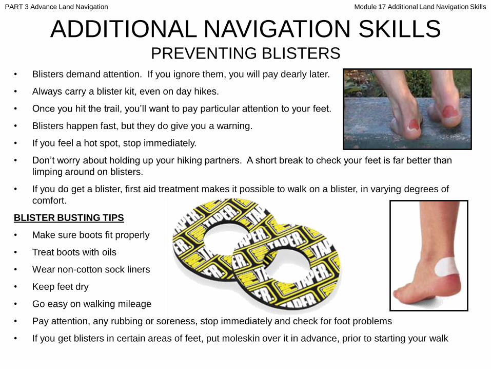
ADDITIONAL NAVIGATION SKILLS PREVENTING BLISTERS
• Blisters demand attention. If you ignore them, you will pay dearly later.
• Always carry a blister kit, even on day hikes.
• Once you hit the trail, you’ll want to pay particular attention to your feet.
• Blisters happen fast, but they do give you a warning.
• If you feel a hot spot, stop immediately.
• Don’t worry about holding up your hiking partners. A short break to check your feet is far better than
limping around on blisters.
• If you do get a blister, first aid treatment makes it possible to walk on a blister, in varying degrees of
comfort.
BLISTER BUSTING TIPS
• Make sure boots fit properly
• Treat boots with oils
• Wear non-cotton sock liners
• Keep feet dry
• Go easy on walking mileage
• Pay attention, any rubbing or soreness, stop immediately and check for foot problems
• If you get blisters in certain areas of feet, put moleskin over it in advance, prior to starting your walk
PART 3 Advance Land Navigation Module 17 Additional Land Navigation Skills

Any Questions?
PART 3 Advance Land Navigation Module 17 Additional Land Navigation Skills
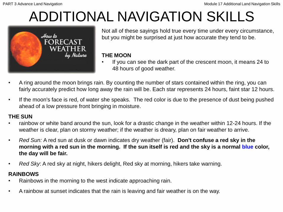
ADDITIONAL NAVIGATION SKILLSNot all of these sayings hold true every time under every circumstance,
but you might be surprised at just how accurate they tend to be.
THE MOON
• If you can see the dark part of the crescent moon, it means 24 to
48 hours of good weather.
• A ring around the moon brings rain. By counting the number of stars contained within the ring, you can
fairly accurately predict how long away the rain will be. Each star represents 24 hours, faint star 12 hours.
• If the moon's face is red, of water she speaks. The red color is due to the presence of dust being pushed
ahead of a low pressure front bringing in moisture.
THE SUN
• rainbow or white band around the sun, look for a drastic change in the weather within 12-24 hours. If the
weather is clear, plan on stormy weather; if the weather is dreary, plan on fair weather to arrive.
• Red Sun: A red sun at dusk or dawn indicates dry weather (fair). Don't confuse a red sky in the
morning with a red sun in the morning. If the sun itself is red and the sky is a normal blue color,
the day will be fair.
• Red Sky: A red sky at night, hikers delight, Red sky at morning, hikers take warning.
RAINBOWS
• Rainbows in the morning to the west indicate approaching rain.
• A rainbow at sunset indicates that the rain is leaving and fair weather is on the way.
PART 3 Advance Land Navigation Module 17 Additional Land Navigation Skills

ADDITIONAL NAVIGATION SKILLSATMOSPHERIC LOW PRESSURE (rain)
• If you find yourself out in a marsh or swamp and the air really
seems to stink more than normal, expect rainy weather.
• Birds and bats have a tendency to fly much lower to the ground
right before a rain due to the ―thinning‖ of the air.
• Smoke hanging low means rain is on the way.
ATMOSPHERIC HIGH PRESSURE (fair)
• Things won't smell quite so strong, fair weather.
• The atmosphere becomes more dense and birds can easily fly at higher altitudes, dry air.
• Smoke rising straight into the air means fair weather.
CLOUDS
• An ability to accurately read cloud formations is invaluable in predicting the weather. For a more detailed
look into this, consult a good book on the weather. Each type of cloud is caused by specific actions in
nature building up to fair weather or rainy weather.
PLANTS
• Pine cones - One of the most reliable of all natural weather indicators are pine cones. In dry weather, pine
cones open out as the scales shrivel up and stand out stiffly. When it is damp, they absorb moisture and
as the scales become flexible again, the cone returns to its normal shape.
• Flowers - flowers bloom in fair weather and close when rain is approaching.
• Grass – dew on the grass, rain will never come to pass. When grass is dry at morning light, look for rain
before the night.
PART 3 Advance Land Navigation Module 17 Additional Land Navigation Skills

Any Questions?
PART 3 Advance Land Navigation Module 17 Additional Land Navigation Skills
Note:
Prior to being issued any training *equipment, you will
be required to sign a “statement of liability” agreeing
to pay for anything you damage or lose.
All items will be inspected and inventoried prior to
your signature and at the end of the training day too.
If you do not intend to sign this statement, then you
may be denied training.
* You may use your own equipment.
PART 3 Advance Land Navigation Module 17 Additional Land Navigation Skills

Now it is time for the following . . .
• Written exam
• Hands-on / Outdoors exam
TESTING
PART 3 Advance Land Navigation Module 17 Additional Land Navigation Skills
THE END OF
LAND NAVIGATION
PRESENTATION
PART 3
Module 17
Additional Skills
PART 3 Advance Land Navigation Module 17 Additional Land Navigation Skills