using the maps- the maps and charts on the following … the maps-the maps and charts on the...
TRANSCRIPT

Using the Maps-The maps and charts on the following pages areincluded to help anglers locate the various salt-water fishing spots within New York City. Achart that precedes the map on the left-hand sideof the page will give details about each locationand assign a number that corresponds to a la-bel on the accompanying map.
Example:
7 V SubwayA
Major Road
○
○
○
○
○
○
○
○
○
○
Getting to a Site-While some of the areas listed have parkingavailable nearby, many do not. Public trans-portation may often be the most convenient wayto travel to fishing access. The subway linesshown on these maps are intended to be a gen-eral guide for subway locations. Detailed sub-way and bus information can be obtained fromthe Metropolitan Transportation Authority(MTA).
More About MapsThe maps included give the generallocation for an access site. Reasonableefforts have been made to ensure theaccuracy and completeness of eachmap. However, accuracy may vary.More detailed street maps can be ob-tained from the following sources:
MTA http://www.mta.info Travel Information Center: (718) 330-1234
Department of Transportation Map Information Unit NYS Department of Transportation State Campus Building 4, Room 105 Albany, New York 12232
USGS U.S. Geological Survey Washington, D.C. 20242
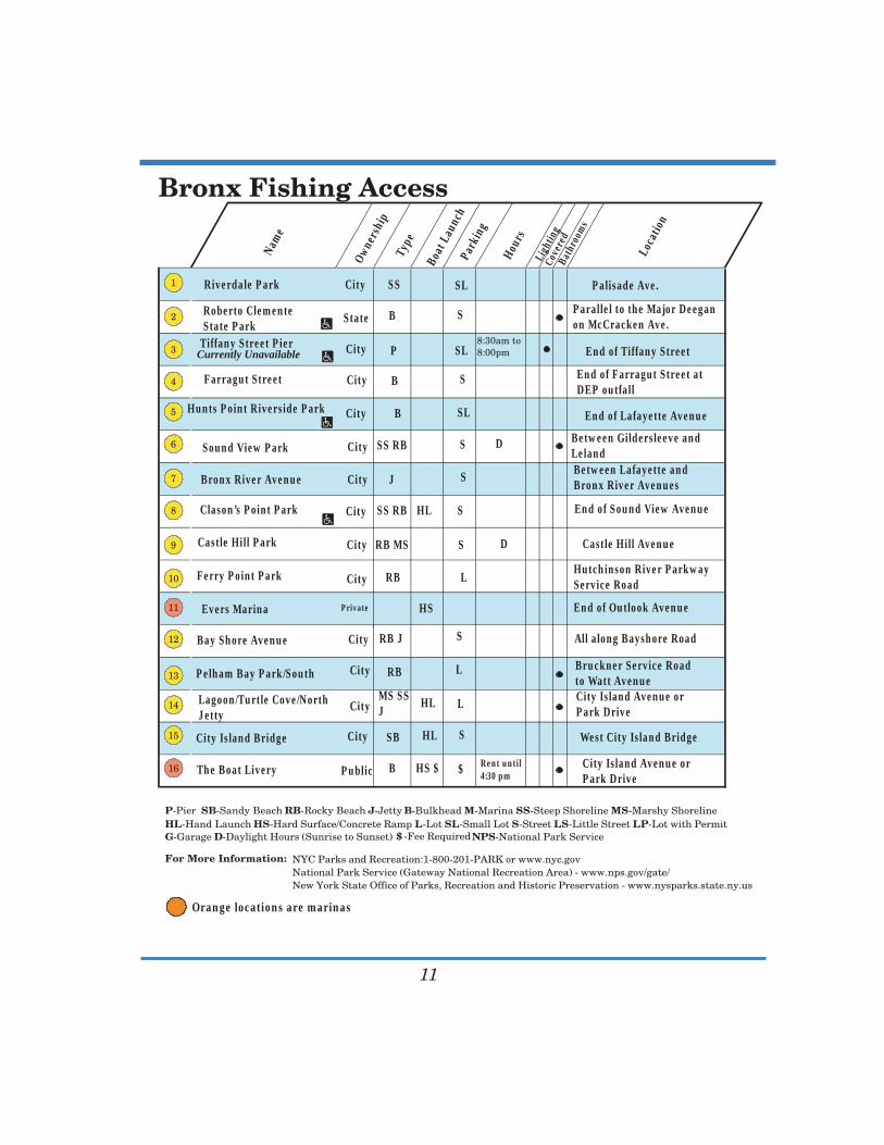
Bronx Fishing Access
11
Currently Unavailable
Nam
e
Owne
rshi
pTy
pe
Boat
Lau
nch
Park
ing
Hour
sLi
ghtin
gCo
vere
dBa
thro
oms
Loca
tion
Riverdale Park
Roberto ClementeState Park
City SS SL Palisade Ave.
State B S Parallel to the Major Deeganon McCracken Ave.
Tiffany Street Pier City P SL End of Tiffany Street
Farragut Street City B S End of Farragut Street atDEP outfall
Hunts Point Riverside Park City B SL End of Lafayette Avenue
Sound View Park City SS RB S D Between Gildersleeve andLeland
Bronx River Avenue City J S Between Lafayette andBronx River Avenues
Clason’s Point Park City SS RB HL S End of Sound View Avenue
Castle Hill Park City RB MS S D Castle Hill Avenue
Ferry Point Park City RB LHutchinson River ParkwayService Road
Evers Marina Private HS End of Outlook Avenue
Bay Shore Avenue City RB J S All along Bayshore Road
Pelham Bay Park/South City RB L Bruckner Service Roadto Watt Avenue
Lagoon/Turtle Cove/NorthJetty
CityMS SSJ
HL L City Island Avenue orPark Drive
City Island Bridge City SB HL S West City Island Bridge
The Boat Livery Public B HS $ $ Rent until4:30 pm
City Island Avenue or Park Drive
P-Pier SB-Sandy Beach RB-Rocky Beach J-Jetty B-Bulkhead M-Marina SS-Steep Shoreline MS-Marshy ShorelineHL-Hand Launch HS-Hard Surface/Concrete Ramp L-Lot SL-Small Lot S-Street LS-Little Street LP-Lot with Permit G-Garage NPS-National Park Service D-Daylight Hours (Sunrise to Sunset)
For More Information: NYC Parks and Recreation:1-800-201-PARK or www.nyc.govNational Park Service (Gateway National Recreation Area) - www.nps.gov/gate/New York State Office of Parks, Recreation and Historic Preservation - www.nysparks.state.ny.us
$ -Fee Required
Orange locations are marinas

Bronx
