using geomorphological and geophysical survey to research
TRANSCRIPT
AUC Geographica 73
1. introduction
The evolution of landforms in Upper Cretaceous and Permo-Carboniferous sedimentary basins of the Bohe-mian massif has been strongly influenced by the presence of saxonian tectonic joints. The distribution and spatial orientation of subvertical joints in the rock massif is fre-quently viewed as a crucial factor influencing the mor-phology of macro-, mezo- and microforms in the relief. in addition, such joints can also be an important factor influencing slope deformations.
This paper presents an analysis of relations between landforms and joint and fault tectonics in Permo-Car-boniferous and Upper-Cretaceous sediments in the south-western part of the Broumovská vrchovina (north-east Bohemia), an area with typical and well developed structural landforms. similar research was realized in the watershed of Jihlava river by Balatka et al. (1999 and 2000). The orientation of tectonic joints in the Brou-movská vrchovina was studied using field measurements on rock outcrops as well as shallow seismic prospection to detect the mechanical properties of joints in deeper parts of the rock massif. The analysis of landforms was carried out in arc gis, based on a 1 : 10,000 digital eleva-tion model.
2. Geological and geomorphological settings
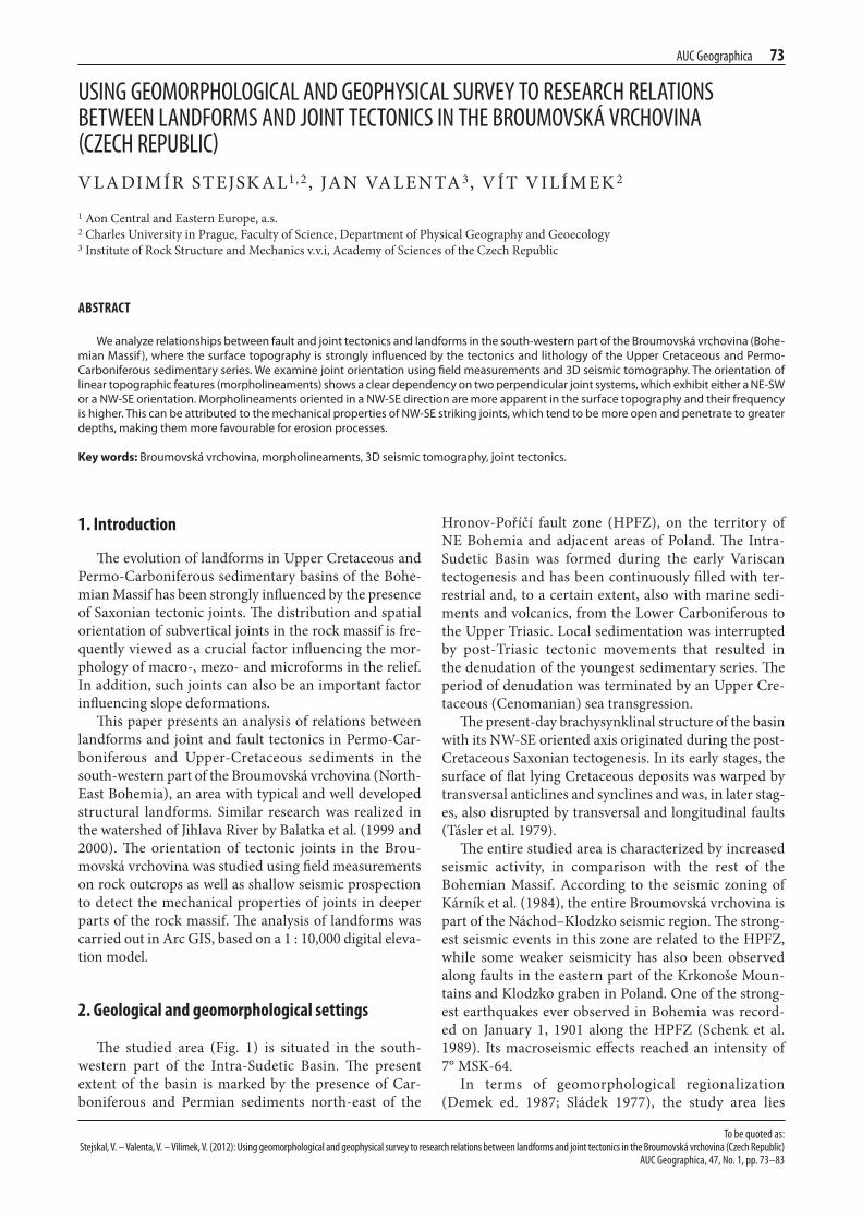
The studied area (Fig. 1) is situated in the south-western part of the intra-sudetic Basin. The present extent of the basin is marked by the presence of Car-boniferous and Permian sediments north-east of the
hronov-Poříčí fault zone (hPFZ), on the territory of ne Bohemia and adjacent areas of Poland. The intra-sudetic Basin was formed during the early variscan tectogenesis and has been continuously filled with ter-restrial and, to a certain extent, also with marine sedi-ments and volcanics, from the lower Carboniferous to the Upper triasic. local sedimentation was interrupted by post-triasic tectonic movements that resulted in the denudation of the youngest sedimentary series. The period of denudation was terminated by an Upper Cre-taceous (Cenomanian) sea transgression.
The present-day brachysynklinal structure of the basin with its nw-se oriented axis originated during the post-Cretaceous saxonian tectogenesis. in its early stages, the surface of flat lying Cretaceous deposits was warped by transversal anticlines and synclines and was, in later stag-es, also disrupted by transversal and longitudinal faults (tásler et al. 1979).
The entire studied area is characterized by increased seismic activity, in comparison with the rest of the Bohemian massif. according to the seismic zoning of Kárník et al. (1984), the entire Broumovská vrchovina is part of the náchod–Klodzko seismic region. The strong-est seismic events in this zone are related to the hPFZ, while some weaker seismicity has also been observed along faults in the eastern part of the Krkonoše moun-tains and Klodzko graben in Poland. one of the strong-est earthquakes ever observed in Bohemia was record-ed on January 1, 1901 along the hPFZ (schenk et al. 1989). its macroseismic effects reached an intensity of 7° msK-64.
in terms of geomorphological regionalization (Demek ed. 1987; sládek 1977), the study area lies
to be quoted as: stejskal, V. – Valenta, V. – Vilímek, V. (2012): Using geomorphological and geophysical survey to research relations between landforms and joint tectonics in the broumovská vrchovina (Czech republic)
AUC Geographica, 47, no. 1, pp. 73–83
UsinG GeomorphoLoGiCAL AnD GeophysiCAL sUrVey to reseArCh reLAtions between LAnDForms AnD Joint teCtoniCs in the broUmoVská VrChoVinA (CzeCh repUbLiC)v l a DimÍr steJsK a l1, 2 , Ja n va len ta 3, v Ít v ilÍm eK 2
1 aon Central and eastern europe, a.s.2 Charles University in Prague, Faculty of science, Department of Physical geography and geoecology3 institute of rock structure and mechanics v.v.i, academy of sciences of the Czech republic
AbstrAct
We analyze relationships between fault and joint tectonics and landforms in the south-western part of the Broumovská vrchovina (Bohe-mian Massif ), where the surface topography is strongly influenced by the tectonics and lithology of the Upper Cretaceous and Permo-Carboniferous sedimentary series. We examine joint orientation using field measurements and 3D seismic tomography. the orientation of linear topographic features (morpholineaments) shows a clear dependency on two perpendicular joint systems, which exhibit either a ne-sW or a nW-se orientation. Morpholineaments oriented in a nW-se direction are more apparent in the surface topography and their frequency is higher. this can be attributed to the mechanical properties of nW-se striking joints, which tend to be more open and penetrate to greater depths, making them more favourable for erosion processes.
Keywords:Broumovská vrchovina, morpholineaments, 3D seismic tomography, joint tectonics.
74 AUC Geographica
within four lower-order geomorphological units: Polická vrchovina, Jestřebí hory, rtyňská brázda and hronovská kotlina.
Polická vrchovina corres ponds to the axial part of the intra-sudetic basin composed of Upper Cretaceous sediments up to 500 m thick. sandstones, siltstones and marlstones from the Cenomanian to Upper turonian ages dominate the lithology of surface sedimentary series. The age of the youngest Upper Cretaceous sediments remained unknown for a long time. eventually, vejlu-pek (1984) confirmed their Coniacian age, on the basis of paleontological studies. This concerns the thick bed-ded sandstones, located in the adršpach-teplice basin, and the messas of ostaš, hejda, hejšovina and Bor, that were preserved as denudation remnants along the axis of the intra-sudetic basin. tásler and Kotlář (1987) attribute these sandstones, with an incomplete thickness of 130 m, to the Březno series.
Polická vrchovina is divided by the transversal skály fault (oriented wsw-ene) into two parts with differ-ent tectonic properties. The northern, relatively uplifted part is characterized by transversal faults, primarily with a sw-ne or wsw-ene strike, while the southern part typically exhibits nw-se oriented faults. Besides the ská-ly fault, other principal tectonic dislocations include the Police fault (striking nw-se) responsible for the subsid-ence of the hejda and eastern reaches of the ostaš mesa by approximately 60 meters (vejlupek 1986) and the Bělý fault (striking nnw-sse), along which the eastern block of the Police basin subsided approximately 60 meters (Demek, Kopecký 1994).
landforms and geomorphological processes in Polická vrchovina are strongly influenced by the struc-ture and lithology of Upper Cretaceous sedimentary series. The main geomorphological features were most likely already present in the Pliocene. The selective denu-dation of brachysynclinally layered sedimentary series with different lithology gave birth to two parallel cuesta belts along the margins of Polická vrchovina and struc-tural plains in its central part. The gradual uplift of the intra-sudetic basin, by approximately 100 m compared to the northern part of the Bohemian Cretaceous Basin, resulted in a Pleistocene rejuvenation of erosion process-es and a series of present-day river networks, belonging to the catchments of the metuje and Úpa rivers (tásler et al. 1979).
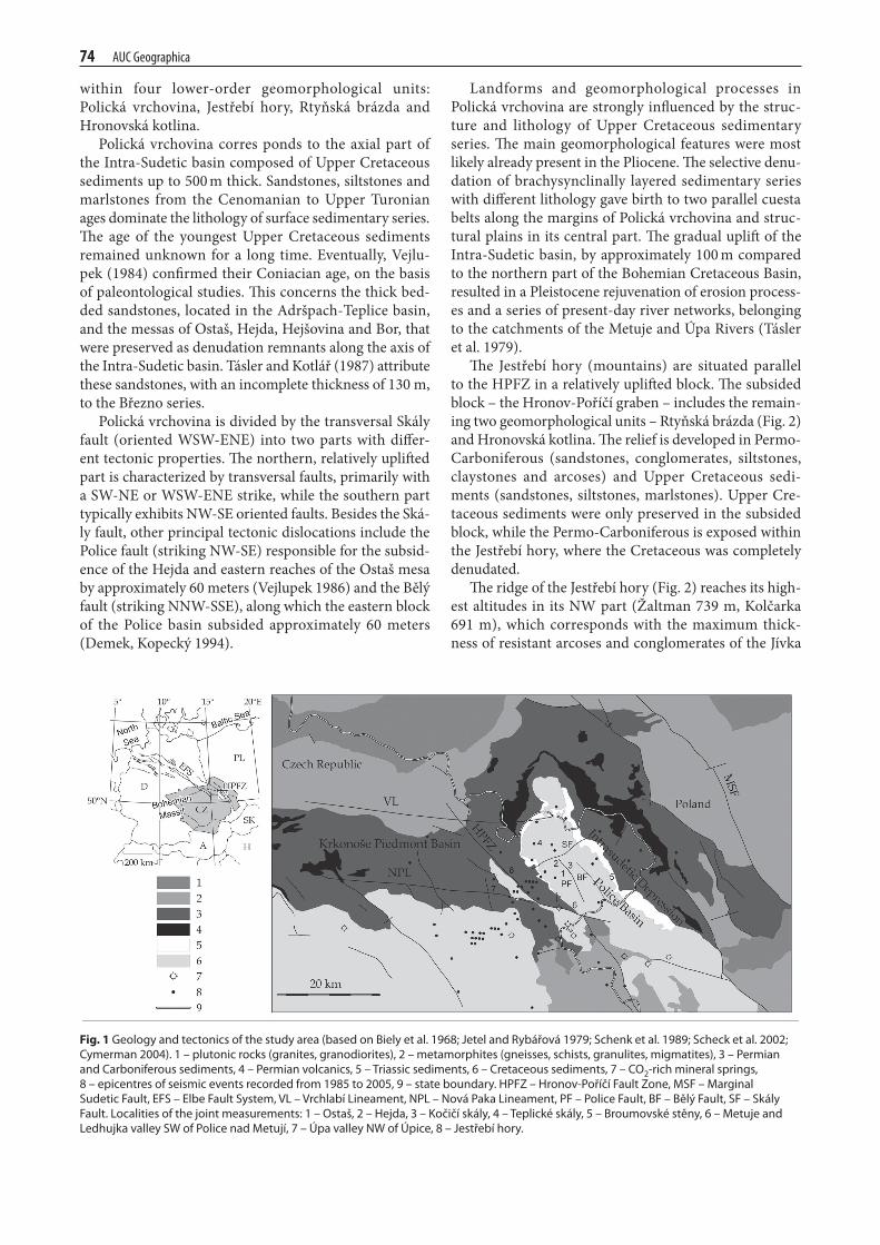
The Jestřebí hory (mountains) are situated parallel to the hPFZ in a relatively uplifted block. The subsided block – the hronov-Poříčí graben – includes the remain-ing two geomorphological units – rtyňská brázda (Fig. 2) and hronovská kotlina. The relief is developed in Permo-Carboniferous (sandstones, conglomerates, siltstones, claystones and arcoses) and Upper Cretaceous sedi-ments (sandstones, siltstones, marlstones). Upper Cre-taceous sediments were only preserved in the subsided block, while the Permo-Carboniferous is exposed within the Jestřebí hory, where the Cretaceous was completely denudated.
The ridge of the Jestřebí hory (Fig. 2) reaches its high-est altitudes in its nw part (Žaltman 739 m, Kolčarka 691 m), which corresponds with the maximum thick-ness of resistant arcoses and conglomerates of the Jívka
Fig.1 Geology and tectonics of the study area (based on Biely et al. 1968; Jetel and rybářová 1979; schenk et al. 1989; scheck et al. 2002; Cymerman 2004). 1 – plutonic rocks (granites, granodiorites), 2 – metamorphites (gneisses, schists, granulites, migmatites), 3 – Permian and Carboniferous sediments, 4 – Permian volcanics, 5 – triassic sediments, 6 – Cretaceous sediments, 7 – Co2-rich mineral springs, 8 – epicentres of seismic events recorded from 1985 to 2005, 9 – state boundary. HPFZ – Hronov-Poříčí Fault Zone, MsF – Marginal sudetic Fault, eFs – elbe Fault system, vl – vrchlabí lineament, nPl – nová Paka lineament, PF – Police Fault, BF – Bělý Fault, sF – skály Fault. localities of the joint measurements: 1 – ostaš, 2 – Hejda, 3 – Kočičí skály, 4 – teplické skály, 5 – Broumovské stěny, 6 – Metuje and ledhujka valley sW of Police nad Metují, 7 – Úpa valley nW of Úpice, 8 – Jestřebí hory.
AUC Geographica 75
series (Upper Carboniferous – stephanian). in this area, the ridge exhibits the characteristics of a cuesta. The denudational sw facing slope under the steep cuesta scarp is developed in less resistant aleuropelites of the svatoňovice series (Upper Carboniferous – westphal-ian, stephanian). The structural backslope of the cues-ta, facing to the ne is inclined more or less to conform (10–20° to the ne) to the dip of arcoses and conglom-erates of the Jívka series (25–30° to the ne). The ridge-crest runs parallel to the hPFZ and is not dissected by the backward erosion of streams flowing in the lower parts of both marginal slopes of the Jestřebí hory. Fur-ther to se the Jestřebí hory range exhibits lower altitudes (maternice 546 m). Compared to the Žaltman area, the ridge crest is more frequently dissected by backward ero-sion. The lithology of sedimentary series is characterized by the predominance of aleuropelites over arcoses and conglomerates, which results in a prevalence of smooth landforms.
rtyňská brázda and hronovská kotlina are tectonic depressions situated along the foot of the Jestřebí hory, on the territory of the hronov-Poříčí graben. They are characterized by smooth reliefs formed in Upper Creta-ceous deposits and by the occurrence of flat floored and shallow fluvial valleys. Both depressions are bounded by relatively uplifted fault scarps. morphologically the most apparent is the ne boundary, the marginal fault scarp of the Jestřebí hory.
3. Methods
3.1 Joint measurements
within the studied area, joint measurements were car-ried out in different sedimentary formations in following localities (Fig. 1):– thick bedded sandstones from the Březno series
(Upper Cretaceous – Coniacian). measurements were carried out in the following localities: ostaš, hejda, Kočičí skály and teplické skály.
– Thick bedded sandstones from the Jizera series (mid-dle–Upper turonian). measurements were carried out in the middle part of Broumovské stěny, east of the municipality of slavný.
– spongilites from the Jizera series. measurements were carried out on outcrops in the metuje and ledhujka valleys sw of Police nad metují.
– Permo-Carboniferous sediments. measurements were carried out in sandstones from the trutnov series on outcrops in the Úpa river valley, nw of Úpice and on outcrops of Žaltman arcoses (Jívka strata) in the nw part of Jestřebí hory.most of the measurements (1,113 in total) were car-
ried out in the thick bedded sandstones of the Březno and Jizera series, thanks to a large number of outcrops in the rock cities. There were considerably less measure-ments carried out in the spongilites of the Jizera series
Fig.2 the flat relief of rtyňská brázda furrow near Batňovice. the uplifted block of Jestřebí hory is located in the background

76 AUC Geographica
(180 in total) and in the Permo-Carboniferous sediments (153 in total), where the presence of surface outcrops is significantly limited. The measurements in different localities are shown in Fig 3.
For comparison the orientation of tectonic joints and faults (Fig. 4), the orientation of faults was measured in 1 : 25,000 and 1 : 50,000 geological maps. altogether, 88 km of tectonic faults were subject to analysis in Permo-Carboniferous sediments and 64 km in Upper-Cretaceous sediments.
3.2 Analysis of morpholineaments
in order to assess manifestations of fault and joint tec-tonics in landforms’ morphology, we used a spatial anal-ysis of morpholineaments method (Badura et al. 2003; Štěpančíková et al. 2008). morpholineaments are defined as linear elements of relief, e.g. mountain fronts, ridge-crests, river networks, linearly distributed groundwater springs, etc. within the studied area, we treated separate-ly morpholineaments in the Upper Cretaceous sediments of the Polická vrchovina and Permo-Carboniferous sedi-ments of the Jestřebí hory. The reason for this separate treatment was the detection of possible differences in the manifestations of fault and joint tectonics, in areas dif-fering in basement lithology. in addition to that, we dis-tinguished between morpholineaments delineated along the drainage network and morpholineaments delineated as straight-line ridge-crests, cuesta scarps or foothills of structural scarps or fault scarps. For the purpose of sim-plification, these two groups of morpholineaments will be referred to hereafter in the text as valley-type and topo-graphic lineaments, respectively.
all morpholineaments were delineated based on digital topographic maps of 1 : 10,000 scale and proc-essed in arc gis. The valley-type morpholineaments were obtained by converting the drainage network into polylines, composed of a varying number of segments with various lengths and azimuths. The topographic line-aments were delineated in a more subjective way, com-pared to all the other straight-line elements of the relief. in the subsequent spatial analysis, only morpholinea-ments longer than 200 m were taken into account. These were compared with the orientation of tectonic faults and joints within the studied area. altogether, we ana-lyzed 77 km of valley-type and 28 km of topographic mor-pohlimeaments in Permo-Carboniferous sediments and 181 km of valley-type and 78 km of topographic morpho-lineaments in Upper Cretaceous sediments. all the mor-pholineaments, including those shorter than 200 m, are shown in Fig. 5. The orientation of morpholineaments is shown in Fig. 6 and vii.
3.3 3-D seismic tomography
the detection of fractures and the designation of their direction, density, depth of penetration and
“intensity of fracturing” are issues often examined by near-surface geophysics. many geophysical methods have been successfully applied to resolve these issues, often utilising azimuthal change in certain physical parameters. For example, a common technique in shal-low seismic refraction is measurement along the pro-files in different orientations. Changes in the velocities of seismic waves along individual profiles make it pos-sible to estimate profiles which are parallel (faster) or perpendicular (slower) to the strike of a fracture system (e.g. Přikryl et al. 2004). in our study, we use a solu-tion based on 3D seismic tomography (e.g. valenta and Dohnal 2007).
Fractures form in-homogeneities in the rock massif, which might be further accentuated by increased intensi-ties of weathering in the near-surface zone. The weather-ing process essentially decreases the velocities of seismic waves in the rock. if fractures form entire fracture sys-tems and are oriented in a certain direction (as in the case of fractures controlled by tectonic stress) then they are responsible for anisotropy of seismic waves. it should be emphasised that the wavelength of seismic waves as well as the geophone step are much larger than the size of the fractures and, consequently, the individual fractures can-not be determined.
in the event that fractures are localised in certain pre-determined zones (e.g. zones with different mineralogi-cal composition, structure, different parts of folds, etc.) and these zones are sufficiently large (compared to the size of the mesh of seismic inversion method applied), then they can be detected directly using seismic meth-ods. mechanical disintegration followed by an increased intensity of weathering results in a decrease in the veloci-ties of seismic waves and the zones would appear as elon-gated low velocity zones. in contrast, if the zones are too small (again, compared to the size of the mesh of the seis-mic inversion) to be resolved directly, we end up with low and high velocity zones but, due to low resolution, these resolved zones might not necessarily be identical to the actual zones.
The testing locality was situated on a slightly inclined structural plain, at the foothill of the ostaš mesa in the central part of the Polická vrchovina. The underlying rock is formed of sub-horizontally layered spongilites and fine-grained sandstones of the Jizera series. The strata dip is up to 10°. seismic receivers were distributed along two concentric circles with the diameters of 30 and 60 metres. a sledgehammer was used as a source of seismic energy. to record seismic waves three-component Br3 seismo-graphs were used (Brož 2000); however, in this case, only the P-waves were processed. The sites of the “shots” were identical with the locations of geophones and addi-tional “shots” were deployed outside of the outer circle and inside the inner circle. a total of 13 seismographs and 21 shots were deployed. This configuration made it possible to reach an effective survey depth of 15 metres (valenta 2007). Data were processed by the first arrival

AUC Geographica 77
picking. The maximum error of reciprocal travel times was less than 5%. Picks were processed by Fast, a travel time tomography package by Colin Zelt (Zelt and Barton 1998). This program uses finite difference calculations for travel time and time field computations. ray tracing is performed “backwards”, perpendicular to the isochrons of the time field. The program uses smoothness and flat-ness constraints, thus seeking the smoothest and flattest model.
4. results and Discussion
4.1 Analysis of joint measurements
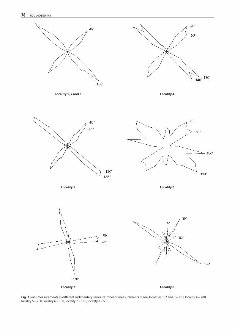
The results of joint measurements are shown in Fig. 3. They can be summarized in the following points:– Joint tectonics in the area of Broumovská vrchovina
(i.e. east of hPFZ) exhibit two dominant directions – approximately ne-sw and nw-se. more precisely, the following directions were identified: 40–50° and 130–140° in thick bedded sandstones (localities 1–5), 40–60° and 120–140° in spongilites of the Jizera series (locality 6) and 30° and 125° in the Žaltman arko-ses (locality 8). These primary directions are always slightly shifted to the north (i.e. counter clockwise) with respect for the orientation of the main tectonic faults (cf. Fig. 4a) manifesting a prevailing strike of 50–80° and 130–170° in the Upper Cretaceous forma-tions of Polická vrchovina and 60–80° and 140° in the Permo-Carboniferous sediments of Jestřebí hory.
– Joint orientation in sandstones from the trutnov series in the Úpa valley (west of hPFZ) exhibits sub-stantially different prevailing directions: 80–90° (n-e) and 170° (e-w). The reason for the different orien-tation of tectonic joints in areas e and w of hPFZ can be seen in the differing orientation of stress fields along both sides of hPFZ at the time when the joints originated.
– The joint measurements exhibit considerably higher variation in sediments different from the Upper Cre-taceous thick bedded sandstones. several different directions can be observed both in arcoses of the Jív-ka strata and, particularly, in spongilites of the Jizera series, where n-s is the most pronounced direction.
– Different localities selected for joint measurements in the thick bedded sandstones of Polická vrchovina were selected so that they were situated in different tectonic blocks (Fig. 1), i.e. teplické skály n of the skály fault, ostaš s of the skály fault and w of the Police fault, hejda and Kočičí skály s of the skály fault and between the Police and Bělý fault and Broumovské stěny s of the skály fault and e of the Bělý fault. Between particular localities no significant differenc-es in joint orientation were observed, which suggests uniform orientation of stress fields throughout the entire basin at the time of the joints’ origin.
4.2 Analysis of morpholineaments
summarizing the results of spatial analysis of morpho-lineaments, we came to the following observations:– in all cases we can clearly observe more or less pro-
nounced directivity of morpholineaments, typical with one or two maxima of concentration in the ne-sw or nw-se quadrant, respectively.
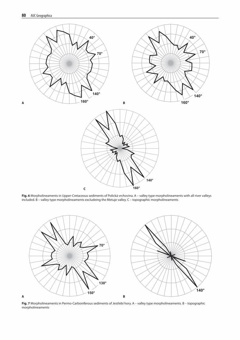
– The orientation of valley-type morpholineaments in the Upper-Cretaceous sediments in Polická vrchovi-na has maxima between 40 and 70° in the ne quad-rant and 140 and 160° in the se quadrant (Fig. 6a and B). Upon removing the metuje river valley meas-urements, where we can expect a lower degree of dependency on joint tectonics, we observe the same orientation of maxima for the entire remaining set of morpholineaments; however, these maxima are much more dominant due to the lower variability of observations (Fig. 6B). in both cases (i.e. with and without the metuje valley), there are two obvious maxima in both quadrants, where the first one (40 and 140°) corresponds to the orientation of joints and the second one (140 and 160°) corresponds to the orientation of faults.
– The orientation of topographic morpholineaments in Polická vrchovina (Fig. 6C) reaches its maximum frequency at 140 and 160°. The maxima in the ne quadrant (40 and 60–80°) are somewhat suppressed by the presence of long straight line fault scarps along the Police and Bělý faults and cuestas strik-ing nw-se. similar to the valley morpholineaments, two maxima in the se quadrant are observed, which correspond to the orientation of tectonic joints and faults.
– The orientation of the valley-type morpholineaments in the Permo-Carboniferous sediments of Jestřebí hory (Fig. viia) has maxima at 70, 130 and 150°. The two maxima that are related to the different orienta-tion of joints (150°) and faults (130°) can be identified in the sw quadrant only.
– The topographic morpholineaments in the Permo-Carboniferous sediments (Fig. viiB) have only one distinct maximum, at 140°. The second maximum in the ne quadrant is again suppressed by the presence of the nw-se direction, along which the whole ridge of Jestřebí hory is oriented.
– generally the valley-type morpholineaments exhibit considerably higher variability of directions. this is especially apparent when the metuje river valley (Fig. 6) is included. The reason is clearly the higher intensity of erosion developments in the river valleys, as compared to the straight fault scarps which are not affected by river erosion and which represent the majority of the topographic morpholineaments.
– Both in the Upper Cretaceous sediments of the Polická vrchovina and the Permo-Carboniferous sediments of the Jestřebí hory we observe that both types of
78 AUC Geographica
Fig.3 Joint measurements in different sedimentary series. number of measurements made: localities 1, 2 and 3 – 713, locality 4 – 200, locality 5 – 200, locality 6 – 180, locality 7 – 100, locality 8 – 53
Locality7 Locality8
Locality5 Locality6
Locality1,2and3 Locality4

AUC Geographica 79
morpholineaments are more concentrated into the nw-se quadrants. The dominance of nw-se direc-tions is typical, primarily, for topographic morpholine-aments, where the concentration in nw-se quadrants reaches 70% in the Upper Cretaceous and 96% in the Permo-Carboniferous sediments. in order to explain
the prevailing nw-se orientation of morpholinea-ments we carried out a shallow seismic survey in the middle part of Polická vrchovina. our objective was to detect the mechanical properties of tectonic joints that would be favourable for erosion processes concentrated along one particular direction of tectonic joints.
A B
Fig.4 orientation of tectonic faults in Polická vrchovina (A) and Jestřebí hory (B). in total, 64 km were analyzed in Polická vrchovina and 88 km in Jestřebí hory
Fig.5Map of morpholineaments of both types delineated in the studied area of Polická vrchovina and Jestřebí hory
80 AUC Geographica
40°
70°
140°
160°
40°
70°
140° 160°
140°
160°
A B
C
Fig.6 Morpholineaments in Upper-Cretaceous sediments of Polická vrchovina. A – valley type morpholineaments with all river valleys included. B – valley type morpholineaments excludeing the Metuje valley. C – topographic morpholineaments
Fig.7 Morpholineaments in Permo-Carboniferous sediments of Jestřebí hory. A – valley type morpholineaments. B – topographic morpholineaments
70°
130°
150° 140° A B

AUC Geographica 81
4.3 tectonic joint detection using 3D seismic tomography
we expected the orientation of fracture systems to reveal itself in the form of elongated lower-velocity zones of seismic waves in the direction of fractures. in contrast, regarding the measurements of azimuthal changes in velocity, the orientation of fracture systems is indicated by an azimuth with increased values of seismic wave velocity. The seismic tomography computes velocities for a large portion of the model: in areas where the ray cov-erage is sufficient. hence, lateral and vertical changes in the “fracture zones” can be tracked, i.e. tendencies to fade out or change direction. Cross-sections from the comput-ed model are show in Fig. 8. The low velocity anomalies depict zones weaken by fracturing. The profiles clearly illustrate vertical changes in the fracture systems. Both fracture systems are sub-vertical. The ne-sw fracture system is shallow and prevalent in the near-surface zone but fades out quickly with increasing depth. it is appar-ent down to a depth of approximately 9 metres. in deeper parts of the model, it is overridden by the sudetic nw-se fracture system. to test the correctness of these results we can utilise a previously mentioned method of measure-ment along profiles with different orientations and look for the seismic anisotropy as further proof of the pres-ence of fracture systems. we can benefit from the fact that the refractor was found to be sub-horizontal at a depth of three metres. Therefore the values of apparent veloci-ties are only significantly affected by changes in the seis-mic velocity of the media and not by changes in the slope of interfaces. Thus we can use the azimuthal change in apparent velocities as an indicator of seismic anisotropy, similarly to measurements along profiles with differ-ent orientations. we selected source-receiver pairs for which source-receiver distance ranges between 20 and 30 metres. such pairs are plotted in Fig. 8. The rays con-necting source-receiver pairs in the latter figure are affect-ed by structures in roughly the same depths and, there-fore, any corresponding velocities should be comparable. The azimuthal differences in velocities clearly depict two directions with increased values of apparent velocity – 45° (ne-se) and 315° (nw-se).
our interpretation of the results of 3D seismic tom-ography is consistent with direct joint measurements. we identified two perpendicular, sub-vertical joint sys-tems with nw-se and ne-sw orientations. Joints in the ne-sw direction were not detected deeper than nine metres below the surface, indicating that they close relatively quickly with increasing depth. on the other hand, joints in the nw-se direction were still quite apparent even at a depth of 15 m. This finding is very important, especially when studying the depend-encies between morpholineaments and joint tectonics. in the previous section we concluded that, from the entire studied area, morpholineaments with a nw-se orientation are more frequent than those with a ne-sw orientation. Based on the results of the 3D seismic
tomography, this can be attributed to the differing mechanical properties of both joint systems. The more opened joints aligned in a nw-se direction are more favourable for weathering and erosion processes, which subsequently lead to a higher concentration of land-forms into these directions.
5. conclusions
Direct measurements of tectonic joints in Upper Cretaceous and Permo-Carboniferous sediments revealed two different prevailing directions of perpen-dicular joint systems. two prevailing directions – n-s and e-w – were identified west of the hronov-Poříčí fault zone (hPFZ), while east of the hPFZ, in Jestřebí hory and Polická vrchovina, ne-sw and nw-se direc-tions prevail. The different orientation of tectonic joints east and west of the hPFZ can be explained by differ-ent orientations of stress fields at the time when the joints originated. Compared to the orientation of local tectonic faults, the dominant directions of joints are slightly shifted to the north (i.e. in a counter-clockwise direction). 3D seismic tomography confirmed the joint directions detected by field measurements. in addition, by using this indirect method, we identified different mechanical properties of the ne-sw and nw-se strik-ing joints, i.e. the latter joint system is more opened and penetrates to greater depths.
The orientation of linear topographic features (mor-pholineaments), as identified from 1 : 10,000 topographic
Fig.8Azimuthal distribution of apparent velocities for source-receiver pairs with a distance between 20 and 30 metres. the graph shows two directions of increased velocities – 45° (ne-se) and 315° (nW-se)

82 AUC Geographica
maps, shows clear dependency on the orientation of tec-tonic joints as identified by the two above-mentioned methods. however, morpholineaments with a nw-se orientation are more apparent in surface topography and exhibit a higher frequency of occurrence. This can be attributed to the mechanical properties of the nw-se striking joints which are more susceptible to denudation and erosion processes.
Acknowledgements
The research was supported by the ministry of edu-cation, youth and sports of the Czech republic, project no. msm0021620831 “geographic systems and risk Processes in the Context of global Change and euro-pean integration” and by the Czech science Foundation, project no. ga205/09/1244.
references
BaDUra, J., ZUChiewiCZ, w., goreCKi, a., sroKa, w., PrZyBylsKi, B., ZysZKowsKa, m. (2003): morphotec-tonic properties of the sudetic marginal Fault, sw Poland. acta montana, ser. a, no. 24 (131), Úsmh av čr, Praha, 21–49.
BalatKa, B., PŘiByl v., vilÍmeK v. (1999): geomorfologická analýza reliéfu na styku Křemešnické, Křižanovské a Javořické vrchoviny. geografie, 104, 1, 24–34.
BalatKa, B., PŘiByl v., vilÍmeK v. (2000): morfotektonické rysy reliéfu v povodí horní Jihlavy. geografie, 105, 3, 276–285.
Biely, a., BUDay, t., DUDeK, a., FUsÁn, o., KoDym, o., KoPeCKÝ, l., KUthan, m., malKovsKÝ, m., matěJKa, a., sattran, v., svoBoDa, J. (1968): tektonická mapa československa. ÚÚg, Praha.
BroŽ, m. (2000): Detection of the origin time and seismic ground motion of quarry blasts, acta montana, ser. a, 16 (118), 17–24.
Cymerman, Z. (2004): tectonic map of the sudetes and the Fore-sudetic Block 1 : 200,000, Polish geological institute, warszawa.
DemeK, J, ed. (1987): hory a nížiny: zeměpisný lexikon čsr, academia, Praha, 584 p.
DemeK, J., KoPeCKÝ, J. (1994): geomorfological processes and landforms in the southern part of the Polická vrchovina high-land (Czech republic). geoJournal, 32, 3, Kluwer academic Publishers, Dordrecht/Boston/london, 231, 240.
Jetel, J., ryBÁŘovÁ, l. (1979): minerální vody východočeského kraje, ÚÚg, Praha, 228 s.
KÁrnÍK, v., sChenKovÁ, Z., sChenK, v. (1984): earthquake activity in the Bohemian massif and in the western Carpathi-ans. travaux géophysiques 547 (29), 9, 33.
PŘiKryl, r., vilhelm, J., loKaJÍčeK, t., Pros, Z., KlÍ-ma, K. (2004): Correlation of field seismic refraction data with 3-D laboratory ultrasonic sounding data during exploration of a dimension stone deposit. Journal of applied geophysics, 56, 59–72.
sCheCK, m., Bayer, U., volKer, o., lamarChe, J., Ban-Ka, D., Pharaoh, t. (2002): The elbe Fault system in the
north Central europe – a basement controlled zone of crustal weakness. tectonophysics 360 (1–4), 281–299.
sChenK, v., sChenKovÁ, Z., PosPÍŠil, l. (1989): Fault system dynamics and seismic activity, examples from the Bohemian massif and the western Carpathians. geophysical transactions 35 (1–2), 101, 116.
slÁDeK, J. (1977): Zeměpisné vymezení a regionální členění. in: roček, Z. (ed): Příroda orlických hor a Podorlicka, státní zemědělské nakladatelství, Praha, 13, 87.
ŠtěPančÍKovÁ, P., stemBerK, J., vilÍmeK, v., KoŠŤÁK, B. (2008): neotectonic development of drainage networks in the east sudeten mountains and monitoring of recent fault dis-placements (Czech republic). special issue on: impact of active tectonics and uplift on fluvial landscapes and river valley devel-opment. geomorphology 102, 68–80.
tÁsler, r. et al. (1979): geologie české části vnitrosudetské pánve, ÚÚg v academii, Praha, 292 p.
tÁsler, r., KotlÁŘ, J. (1987): geologie Chráněné krajinné oblasti Broumovsko, unpublished document of ChKo Brou-movsko in Police n. met., 64 p.
valenta, J., Dohnal, J. (2007): 3D seismic travel time survey-ing – a comparison of the time-term method and tomography (an example from an archaeological site). Journal of applied geophysics, 63, 46–58.
valenta, J. (2008): new approaches in high-resolution shallow seismic prospection. acta research reports, 17, 63–74.
valenta, J. (2007): new approaches in high-resolution shallow seismic prospection. PhD Thesis, institute of hydrogeology, engineering geology and applied geophysics, Fac. of science, Charles University in Prague.
veJlUPeK, m. (1984): stáří nejmladších svrchnokřídových pískovců polické pánve.
veJlUPeK, m. (1986): strukturní stavba polické a svatoňovicko, hronovské pánve. věstník ÚÚg, 61, 3, ÚÚg, Praha 111–122.
Zelt, C. a., Barton, P. J. (1998): Three dimensional seismic refraction tomography: a comparison of two methods applied to data from the Faeroe Basin. Journal of geophysical research, 103, 7187–7210.
résuMé
Využití geomorfologického a geofyzikálního výzkumu při studiu vztahů mezi tvary reliéfu a puklinovou tektonikou v broumovské vrchovině (Česko)
v článku byl analyzován vztah mezi zlomovou tektonikou, systémy puklin a povrchovými tvary reliéfu, a to v jz. části Brou-movské vrchoviny, kde se v reliéfu výrazně projevuje tektonická a litologická predispozice sedimentárních souvrství pocházejících z období permo-karbonského a ze svrchní křídy. systémy puklin byly zjištěny při terénních měřeních a z 3D seismické tomografie. směry lineárních topografických prvků (morfolineamentů) vyka-zují závislost na systému vzájemně kolmých směrů puklin (JZ-sv a sZ-Jv). morfolineamenty směru sZ-Jv se v reliéfu projevují výrazněji a frekvence jejich výskytu je také četnější. toto může být přisouzeno jejich mechanickým vlastnostem, jelikož jsou více roze-vřené a pronikají do větší hloubky. této skutečnosti využívají jak zvětrávací, tak i erozní procesy a vede to k častějšímu zastoupení erozních forem reliéfu.

AUC Geographica 83
Vladimír Stejskal 1,2
1 Aon Central and Eastern Europe, a.s.U Prašné brány 1110 00 Prague 1 2 Charles University in Prague, Faculty of Science, Department of Physical Geography and Geoecology128 43 Prague 2Czech RepublicE-mail: [email protected]
Jan ValentaInstitute of Rock Structure and Mechanics, v.v.iAcademy of Sciences of the Czech RepublicV Holešovičkách 41182 09 Praha 8E-mail: [email protected]
Vít Vilímek Charles University in Prague, Faculty of ScienceDepartment of Physical Geography and Geoecology128 43 Prague 2Czech RepublicE-mail: [email protected]