using geojson in oracle database · 2019-01-31 · • both json and xml are self describing (human...
TRANSCRIPT


GeoJSONand the Oracle DatabaseAlbert Godfrind, Spatial Solutions Architect, Oracle
Analytics and Data Summit 2018
Copyright © 2016, Oracle and/or its affiliates. All rights reserved. |
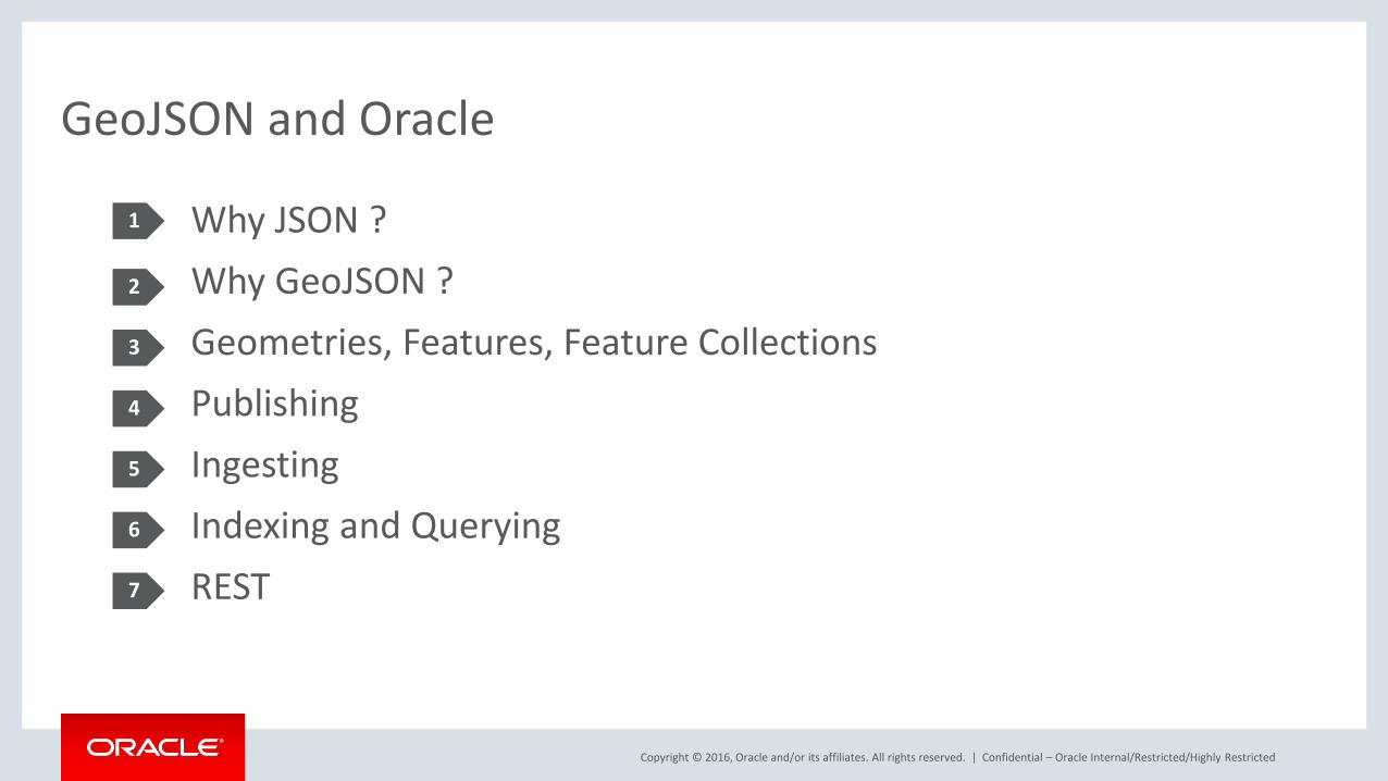
GeoJSON and Oracle
Why JSON ?Why GeoJSON ?Geometries, Features, Feature CollectionsPublishingIngestingIndexing and QueryingREST
Confidential – Oracle Internal/Restricted/Highly Restricted
1
2
3
4
5
6
7
Copyright © 2016, Oracle and/or its affiliates. All rights reserved. |
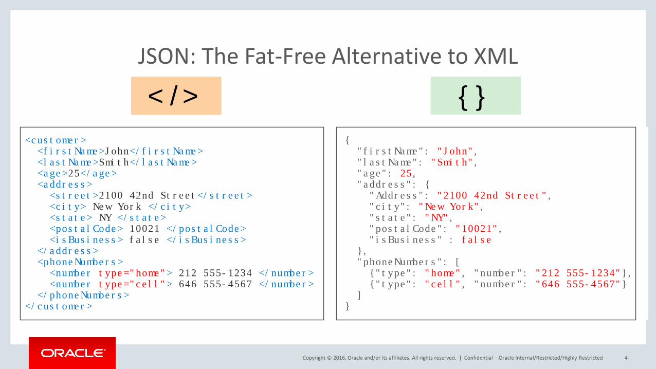
JSON: The Fat-Free Alternative to XML
Confidential – Oracle Internal/Restricted/Highly Restricted 4
<customer><firstName>John</firstName><lastName>Smith</lastName><age>25</age><address><street>2100 42nd Street</street><city> New York </city><state> NY </state><postalCode> 10021 </postalCode><isBusiness> false </isBusiness>
</address><phoneNumbers><number type="home"> 212 555-1234 </number><number type="cell"> 646 555-4567 </number>
</phoneNumbers></customer>
{ "firstName": "John","lastName": "Smith","age": 25,"address": {"Address": "2100 42nd Street","city": "New York","state": "NY","postalCode": "10021","isBusiness" : false
},"phoneNumbers": [{"type": "home", "number": "212 555-1234"},{"type": "cell", "number": "646 555-4567"}
]}
</> {}
Copyright © 2016, Oracle and/or its affiliates. All rights reserved. |
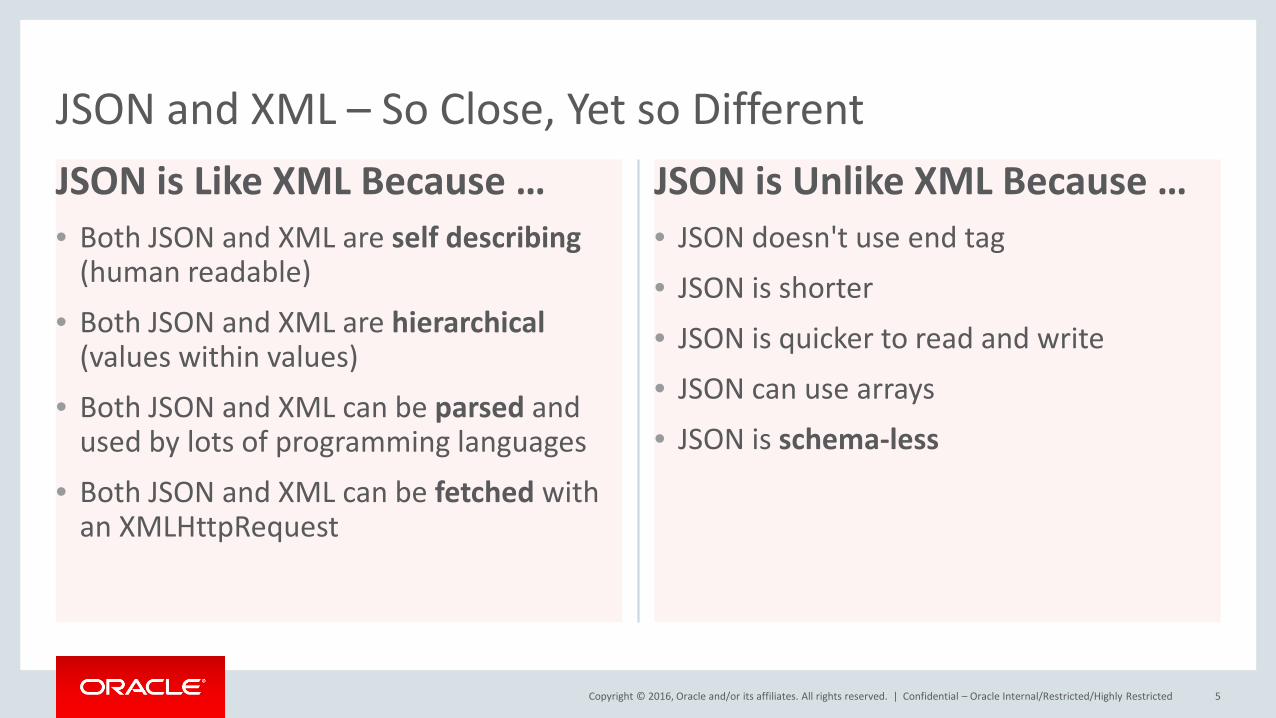
JSON is Like XML Because …• Both JSON and XML are self describing
(human readable)
• Both JSON and XML are hierarchical(values within values)
• Both JSON and XML can be parsed and used by lots of programming languages
• Both JSON and XML can be fetched with an XMLHttpRequest
JSON is Unlike XML Because …• JSON doesn't use end tag
• JSON is shorter
• JSON is quicker to read and write
• JSON can use arrays• JSON is schema-less
Confidential – Oracle Internal/Restricted/Highly Restricted 5
JSON and XML – So Close, Yet so Different
Copyright © 2016, Oracle and/or its affiliates. All rights reserved. |
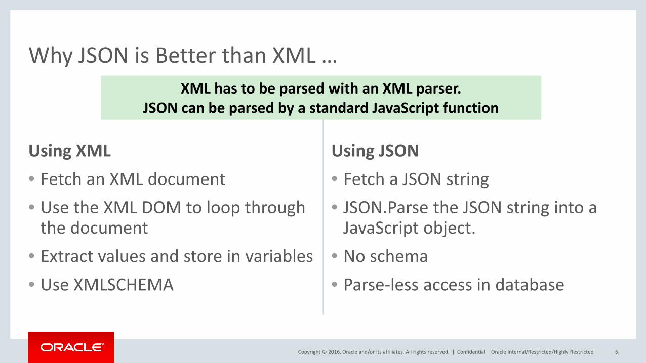
Using XML• Fetch an XML document• Use the XML DOM to loop through
the document• Extract values and store in variables• Use XMLSCHEMA
Using JSON• Fetch a JSON string• JSON.Parse the JSON string into a
JavaScript object.• No schema• Parse-less access in database
Confidential – Oracle Internal/Restricted/Highly Restricted 6
Why JSON is Better than XML …XML has to be parsed with an XML parser.
JSON can be parsed by a standard JavaScript function
Copyright © 2016, Oracle and/or its affiliates. All rights reserved. |
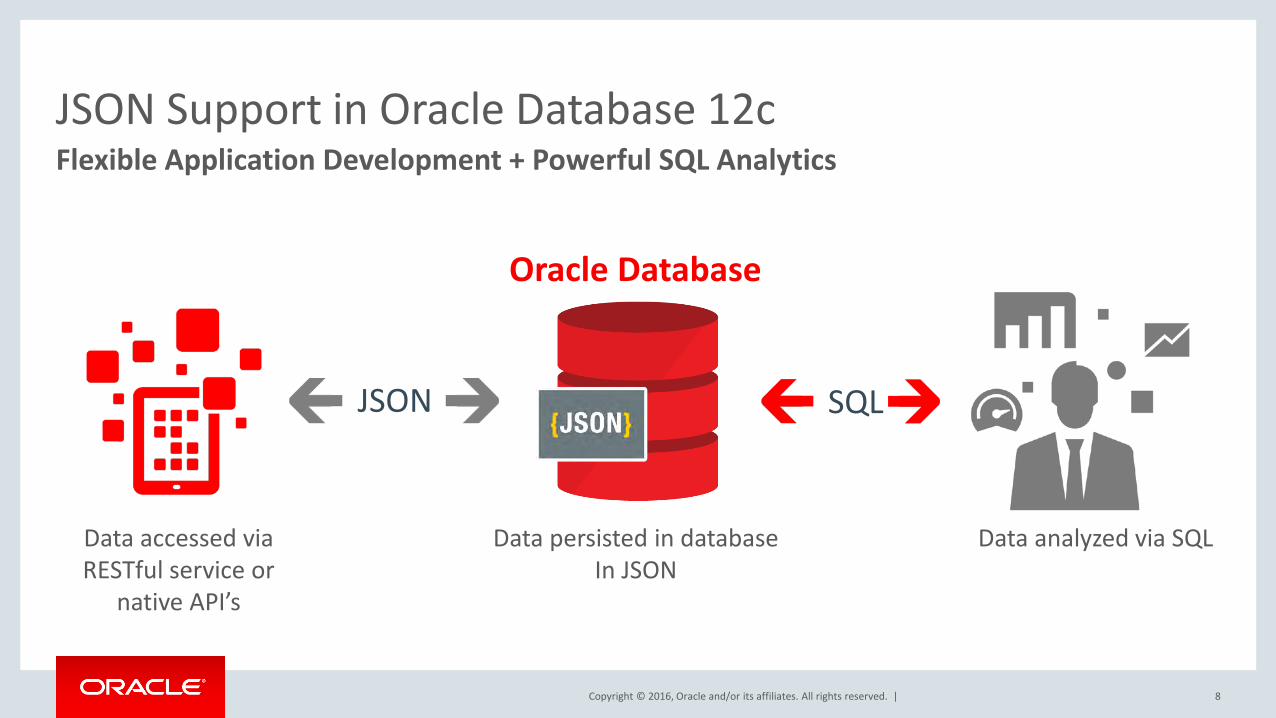
JSON Support in Oracle Database 12cFlexible Application Development + Powerful SQL Analytics
JSON
Data accessed via RESTful service or
native API’s
Data persisted in databaseIn JSON
Data analyzed via SQL
Oracle Database
SQL
8
Copyright © 2016, Oracle and/or its affiliates. All rights reserved. |
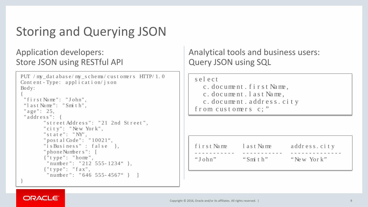
Storing and Querying JSONApplication developers:Store JSON using RESTful API
Analytical tools and business users: Query JSON using SQL
9
PUT /my_database/my_schema/customers HTTP/1.0Content-Type: application/jsonBody: {"firstName": "John",“lastName”: "Smith","age": 25,"address": {
"streetAddress": "21 2nd Street","city": "New York","state": "NY","postalCode": "10021“,"isBusiness" : false },"phoneNumbers": [{"type": "home","number": "212 555-1234“ },{"type": "fax","number": "646 555-4567“ } ]
}
select c.document.firstName,c.document.lastName,c.document.address.city
from customers c;”
firstName lastName address.city----------- ----------- --------------“John” “Smith” “New York”
Copyright © 2016, Oracle and/or its affiliates. All rights reserved. |
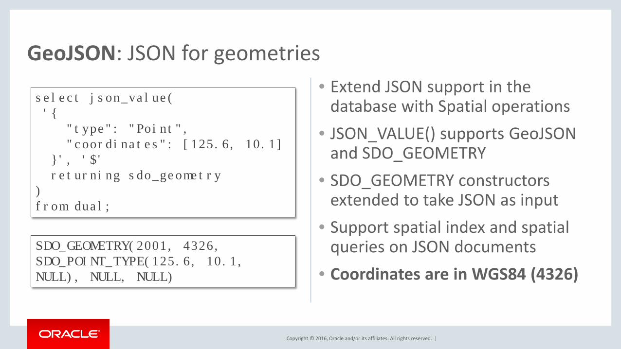
GeoJSON: JSON for geometries• Extend JSON support in the
database with Spatial operations• JSON_VALUE() supports GeoJSON
and SDO_GEOMETRY• SDO_GEOMETRY constructors
extended to take JSON as input• Support spatial index and spatial
queries on JSON documents• Coordinates are in WGS84 (4326)
select json_value('{
"type": "Point","coordinates": [125.6, 10.1]
}', '$' returning sdo_geometry
) from dual;
SDO_GEOMETRY(2001, 4326, SDO_POINT_TYPE(125.6, 10.1, NULL), NULL, NULL)
Copyright © 2016, Oracle and/or its affiliates. All rights reserved. |
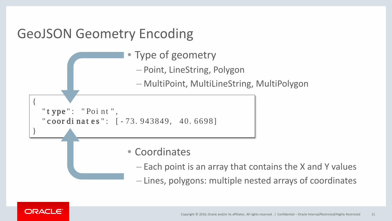
GeoJSON Geometry Encoding• Type of geometry
– Point, LineString, Polygon– MultiPoint, MultiLineString, MultiPolygon
• Coordinates– Each point is an array that contains the X and Y values– Lines, polygons: multiple nested arrays of coordinates
Confidential – Oracle Internal/Restricted/Highly Restricted 11
{"type": "Point","coordinates": [-73.943849, 40.6698]
}
Copyright © 2016, Oracle and/or its affiliates. All rights reserved. |
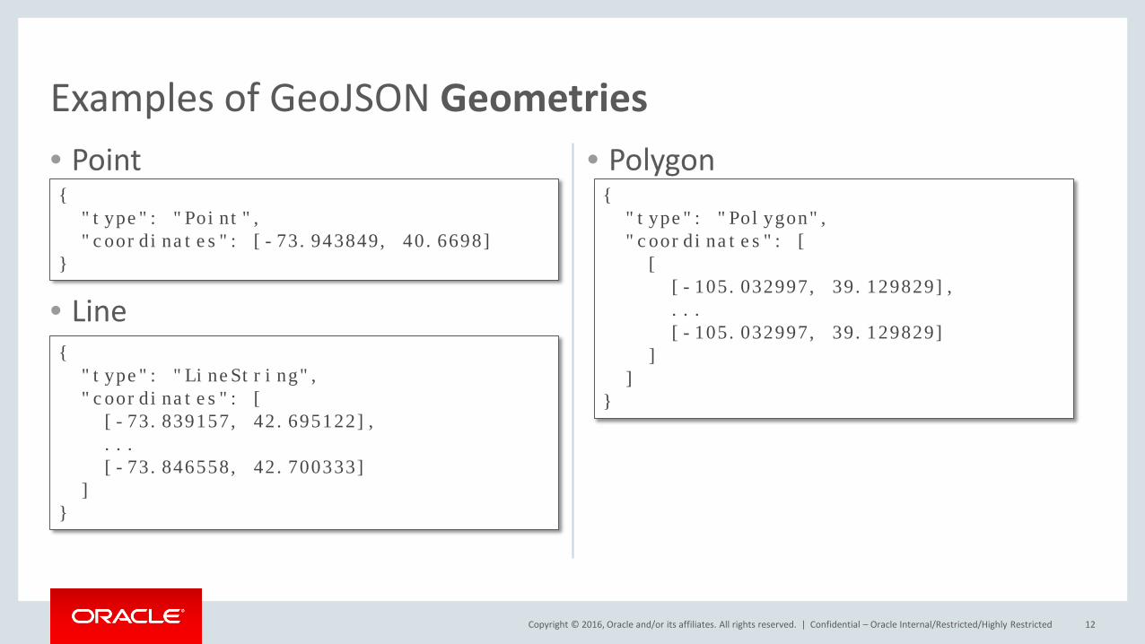
• Point
• Line
• Polygon
Confidential – Oracle Internal/Restricted/Highly Restricted 12
Examples of GeoJSON Geometries
{"type": "Point","coordinates": [-73.943849, 40.6698]
}
{ "type": "LineString","coordinates": [
[-73.839157, 42.695122], ... [-73.846558, 42.700333]
] }
{ "type": "Polygon","coordinates": [ [
[-105.032997, 39.129829], ... [-105.032997, 39.129829]
] ]
}
Copyright © 2016, Oracle and/or its affiliates. All rights reserved. |
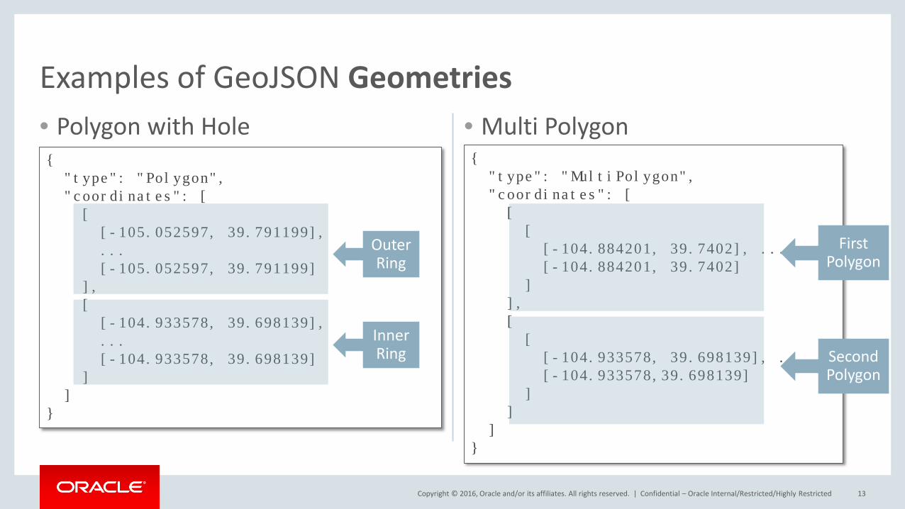
• Polygon with Hole • Multi Polygon
Confidential – Oracle Internal/Restricted/Highly Restricted 13
Examples of GeoJSON Geometries
{ "type": "Polygon","coordinates": [[
[-105.052597, 39.791199], ... [-105.052597, 39.791199]
], [ [-104.933578, 39.698139], ... [-104.933578, 39.698139]
] ]
}
{ "type": "MultiPolygon", "coordinates": [[
[ [-104.884201, 39.7402], ... [-104.884201, 39.7402]
] ], [ [
[-104.933578, 39.698139], ... [-104.933578,39.698139]
] ]
] }
Outer Ring
InnerRing
First Polygon
SecondPolygon
Copyright © 2016, Oracle and/or its affiliates. All rights reserved. |
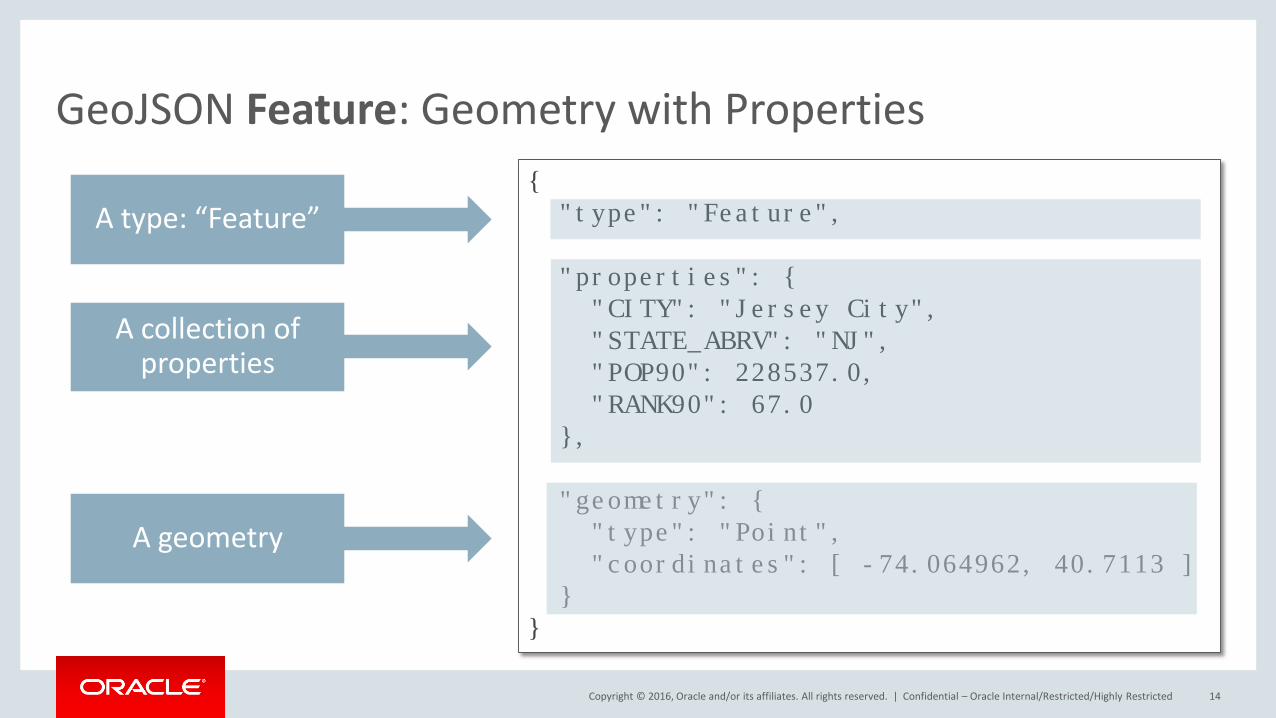
GeoJSON Feature: Geometry with Properties
Confidential – Oracle Internal/Restricted/Highly Restricted 14
{ "type": "Feature",
"properties": {"CITY": "Jersey City","STATE_ABRV": "NJ", "POP90": 228537.0, "RANK90": 67.0
},
"geometry": { "type": "Point", "coordinates": [ -74.064962, 40.7113 ]
} }
A type: “Feature”
A collection of properties
A geometry
Copyright © 2016, Oracle and/or its affiliates. All rights reserved. |
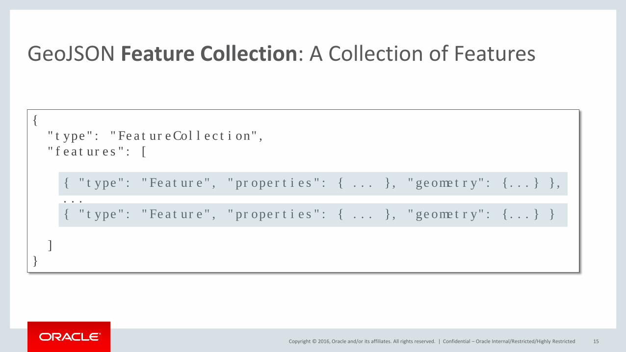
GeoJSON Feature Collection: A Collection of Features
Confidential – Oracle Internal/Restricted/Highly Restricted 15
{ "type": "FeatureCollection", "features": [
{ "type": "Feature", "properties": { ... }, "geometry": {...} },...{ "type": "Feature", "properties": { ... }, "geometry": {...} }
]}
Copyright © 2016, Oracle and/or its affiliates. All rights reserved. |
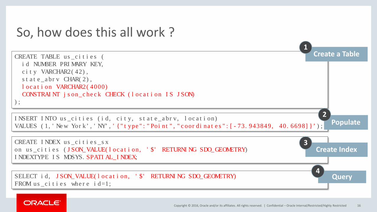
So, how does this all work ?
Confidential – Oracle Internal/Restricted/Highly Restricted 16
CREATE TABLE us_cities (id NUMBER PRIMARY KEY,city VARCHAR2(42),state_abrv CHAR(2),location VARCHAR2(4000)CONSTRAINT json_check CHECK (location IS JSON)
);
SELECT id, JSON_VALUE(location, '$' RETURNING SDO_GEOMETRY) FROM us_cities where id=1;
CREATE INDEX us_cities_sxon us_cities (JSON_VALUE(location, '$' RETURNING SDO_GEOMETRY)INDEXTYPE IS MDSYS.SPATIAL_INDEX;
INSERT INTO us_cities (id, city, state_abrv, location)VALUES (1,'New York’,'NY’,'{"type":"Point","coordinates":[-73.943849, 40.6698]}’);
Create a Table1
Populate2
Create Index3
Query4
Copyright © 2016, Oracle and/or its affiliates. All rights reserved. |
From SDO_GEOMETRY to GeoJSON
Confidential – Oracle Internal/Restricted/Highly Restricted 17
Copyright © 2016, Oracle and/or its affiliates. All rights reserved. |
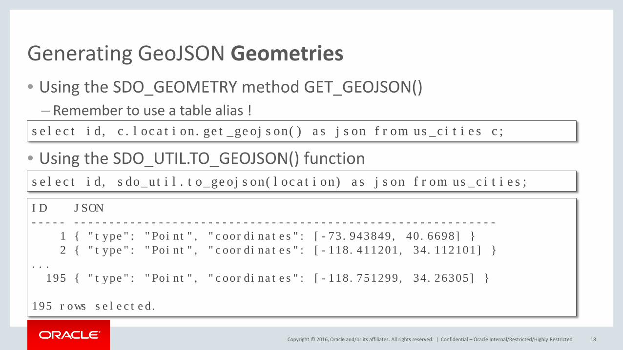
Generating GeoJSON Geometries• Using the SDO_GEOMETRY method GET_GEOJSON()
– Remember to use a table alias !
• Using the SDO_UTIL.TO_GEOJSON() function
Confidential – Oracle Internal/Restricted/Highly Restricted 18
select id, c.location.get_geojson() as json from us_cities c;
select id, sdo_util.to_geojson(location) as json from us_cities;
ID JSON----- ------------------------------------------------------------
1 { "type": "Point", "coordinates": [-73.943849, 40.6698] }2 { "type": "Point", "coordinates": [-118.411201, 34.112101] }
...195 { "type": "Point", "coordinates": [-118.751299, 34.26305] }
195 rows selected.
Copyright © 2016, Oracle and/or its affiliates. All rights reserved. |
Generating GeoJSON Features
Confidential – Oracle Internal/Restricted/Highly Restricted 19
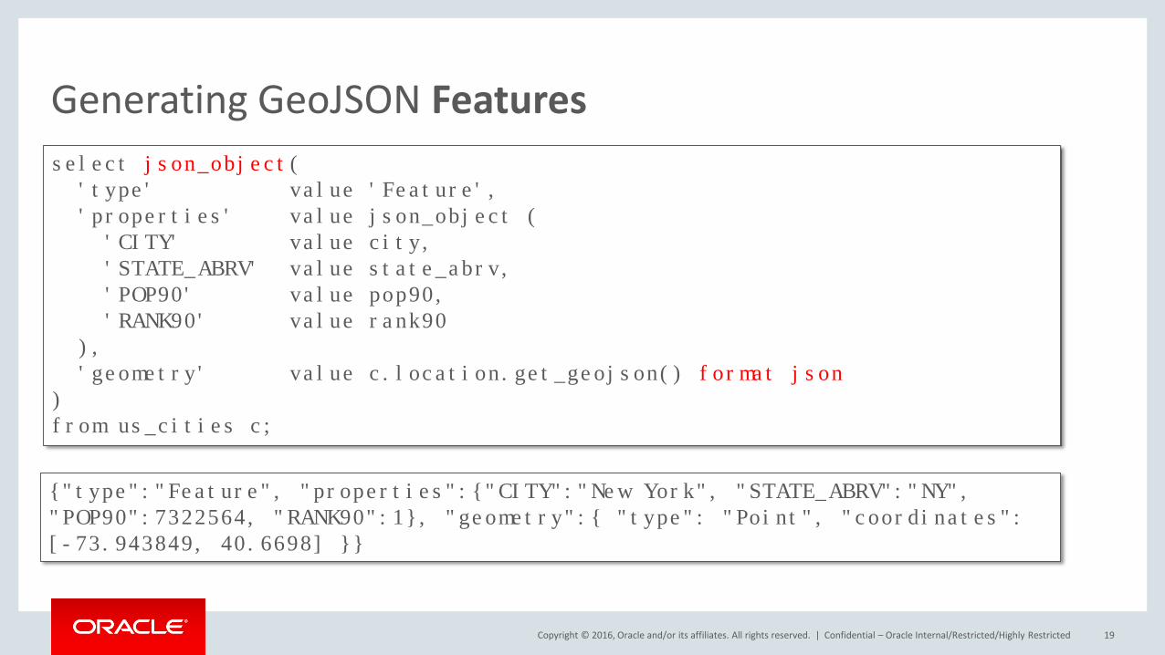
select json_object('type' value 'Feature','properties' value json_object (
'CITY' value city,'STATE_ABRV' value state_abrv,'POP90' value pop90,'RANK90' value rank90
),'geometry' value c.location.get_geojson() format json
)from us_cities c;
{"type":"Feature", "properties":{"CITY":"New York", "STATE_ABRV":"NY","POP90":7322564, "RANK90":1}, "geometry":{ "type": "Point", "coordinates": [-73.943849, 40.6698] }}
Copyright © 2016, Oracle and/or its affiliates. All rights reserved. |
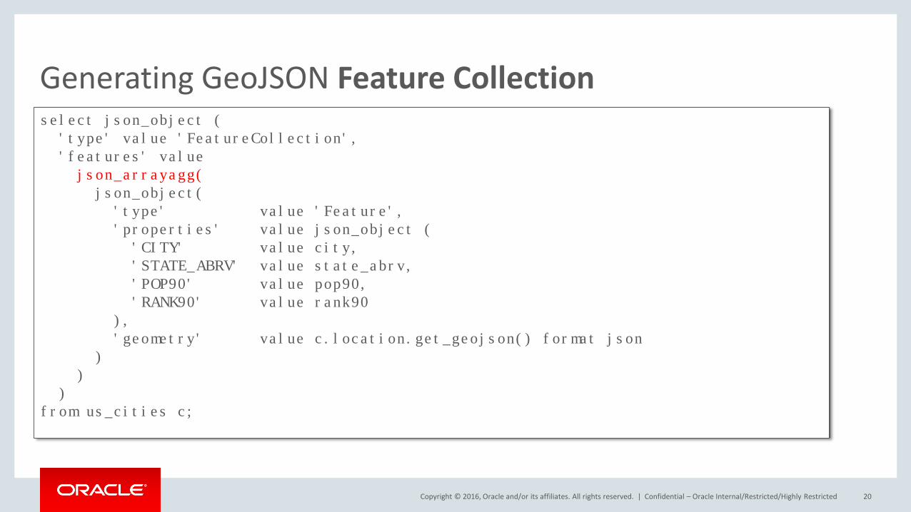
Generating GeoJSON Feature Collection
Confidential – Oracle Internal/Restricted/Highly Restricted 20
select json_object ('type' value 'FeatureCollection','features' valuejson_arrayagg(json_object(
'type' value 'Feature','properties' value json_object ('CITY' value city,'STATE_ABRV' value state_abrv,'POP90' value pop90,'RANK90' value rank90
),'geometry' value c.location.get_geojson() format json
))
)from us_cities c;
Copyright © 2016, Oracle and/or its affiliates. All rights reserved. |
From GeoJSON to SDO_GEOMETRY
Confidential – Oracle Internal/Restricted/Highly Restricted 21
Copyright © 2016, Oracle and/or its affiliates. All rights reserved. |
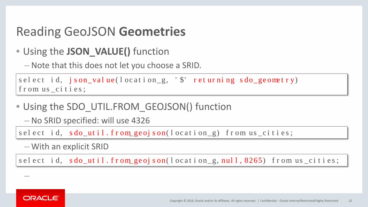
Reading GeoJSON Geometries• Using the JSON_VALUE() function
– Note that this does not let you choose a SRID.
• Using the SDO_UTIL.FROM_GEOJSON() function– No SRID specified: will use 4326
– With an explicit SRID
–
Confidential – Oracle Internal/Restricted/Highly Restricted 22
select id, sdo_util.from_geojson(location_g) from us_cities;
select id, sdo_util.from_geojson(location_g,null,8265) from us_cities;
select id, json_value(location_g, '$' returning sdo_geometry) from us_cities;
Copyright © 2016, Oracle and/or its affiliates. All rights reserved. |
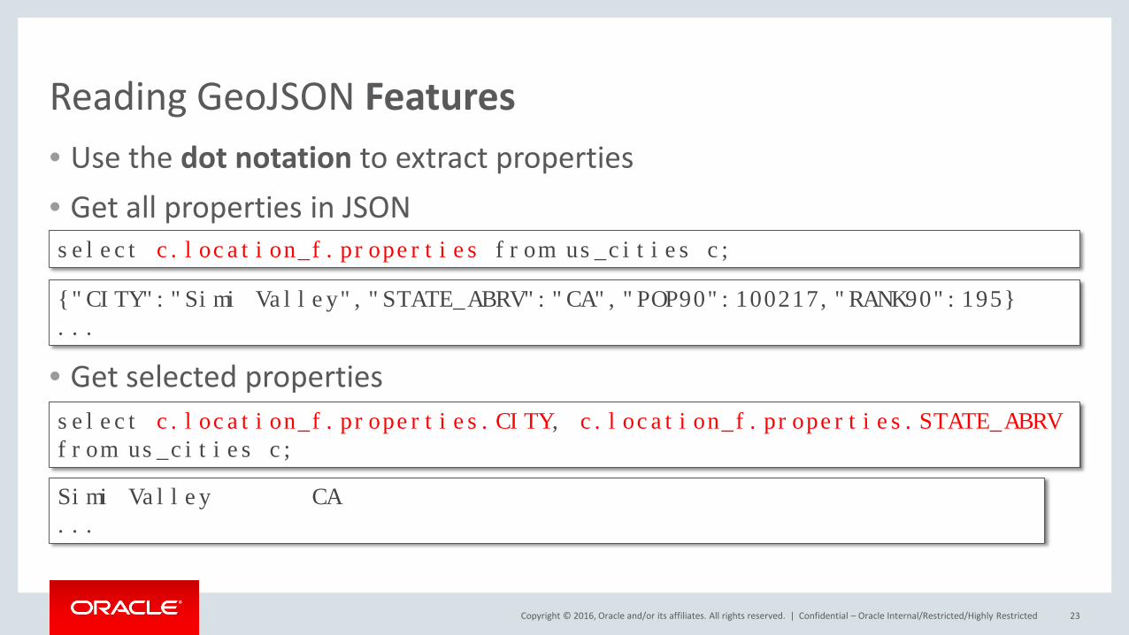
Reading GeoJSON Features• Use the dot notation to extract properties• Get all properties in JSON
• Get selected properties
Confidential – Oracle Internal/Restricted/Highly Restricted 23
select c.location_f.properties from us_cities c;
{"CITY":"Simi Valley","STATE_ABRV":"CA","POP90":100217,"RANK90":195}...
select c.location_f.properties.CITY, c.location_f.properties.STATE_ABRVfrom us_cities c;
Simi Valley CA...
Copyright © 2016, Oracle and/or its affiliates. All rights reserved. |
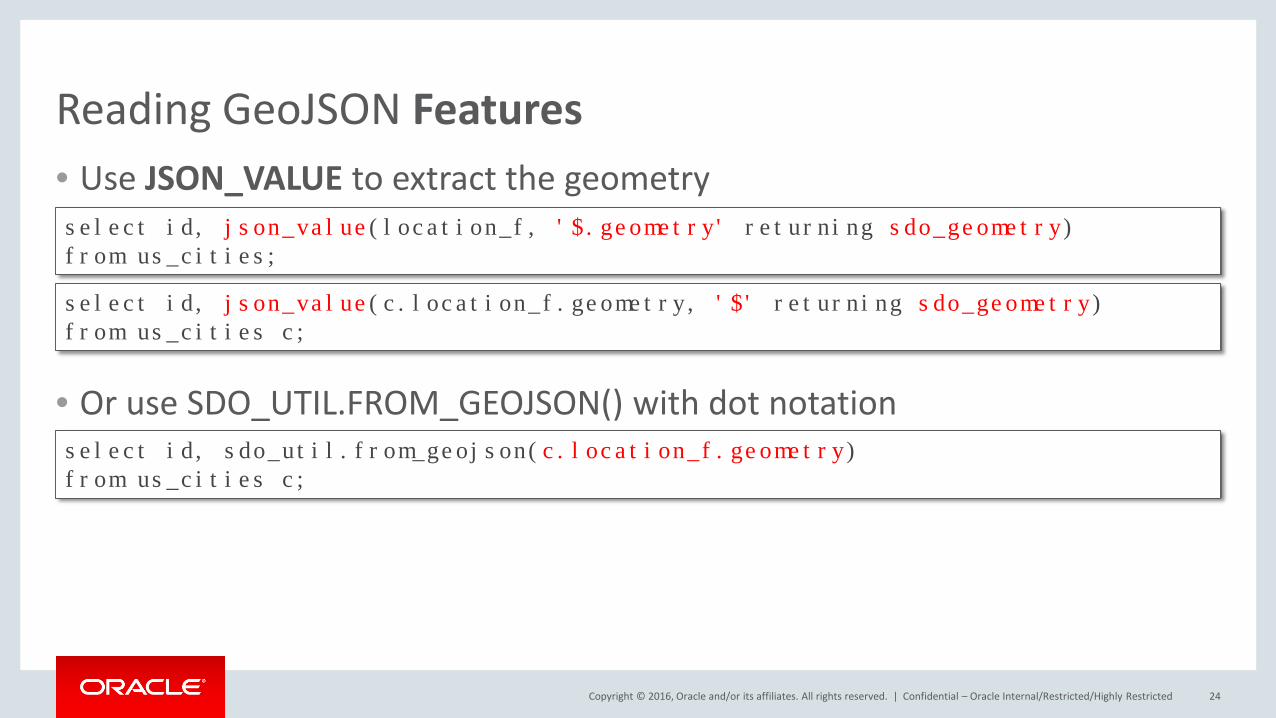
Reading GeoJSON Features• Use JSON_VALUE to extract the geometry
• Or use SDO_UTIL.FROM_GEOJSON() with dot notation
Confidential – Oracle Internal/Restricted/Highly Restricted 24
select id, json_value(location_f, '$.geometry' returning sdo_geometry) from us_cities;
select id, sdo_util.from_geojson(c.location_f.geometry)from us_cities c;
select id, json_value(c.location_f.geometry, '$' returning sdo_geometry) from us_cities c;
Copyright © 2016, Oracle and/or its affiliates. All rights reserved. |
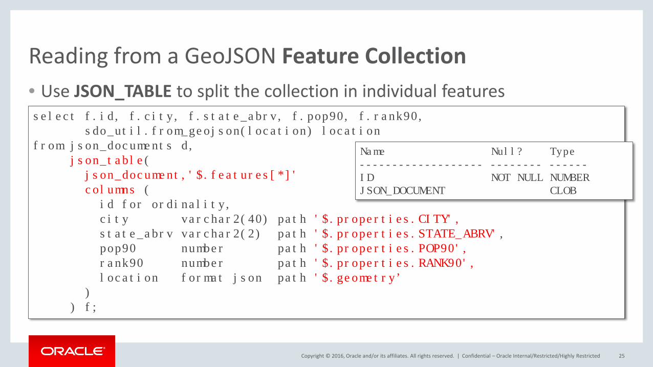
Reading from a GeoJSON Feature Collection• Use JSON_TABLE to split the collection in individual features
Confidential – Oracle Internal/Restricted/Highly Restricted 25
select f.id, f.city, f.state_abrv, f.pop90, f.rank90, sdo_util.from_geojson(location) location
from json_documents d, json_table(
json_document,'$.features[*]' columns (
id for ordinality,city varchar2(40) path '$.properties.CITY',state_abrv varchar2(2) path '$.properties.STATE_ABRV',pop90 number path '$.properties.POP90',rank90 number path '$.properties.RANK90',location format json path '$.geometry’
)) f;
Name Null? Type------------------- -------- ------ID NOT NULL NUMBERJSON_DOCUMENT CLOB
Copyright © 2016, Oracle and/or its affiliates. All rights reserved. |
Indexing and Querying
Confidential – Oracle Internal/Restricted/Highly Restricted 26
Copyright © 2016, Oracle and/or its affiliates. All rights reserved. |
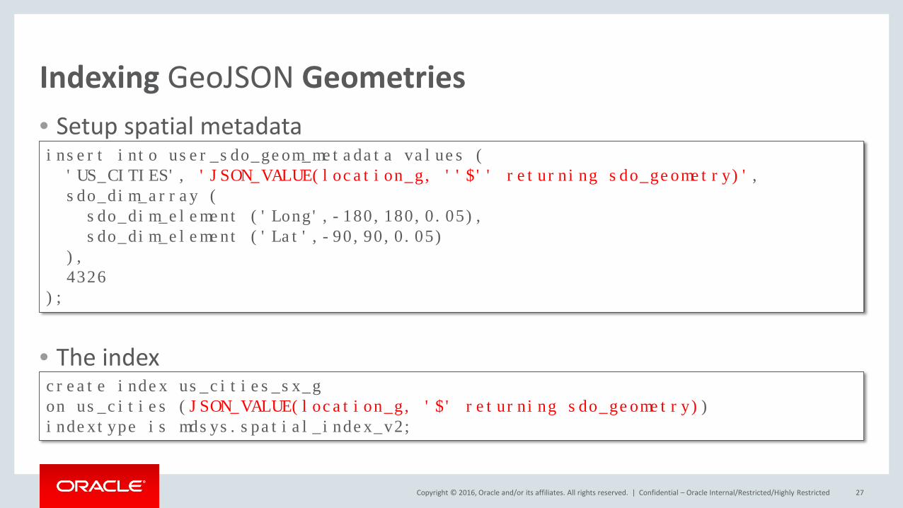
Indexing GeoJSON Geometries• Setup spatial metadata
• The index
Confidential – Oracle Internal/Restricted/Highly Restricted 27
insert into user_sdo_geom_metadata values ('US_CITIES', 'JSON_VALUE(location_g, ''$'' returning sdo_geometry)',sdo_dim_array (
sdo_dim_element ('Long',-180,180,0.05),sdo_dim_element ('Lat',-90,90,0.05)
),4326
);
create index us_cities_sx_gon us_cities (JSON_VALUE(location_g, '$' returning sdo_geometry))indextype is mdsys.spatial_index_v2;

Copyright © 2016, Oracle and/or its affiliates. All rights reserved. |
Indexing GeoJSON Features• Setup spatial metadata
• The index
Confidential – Oracle Internal/Restricted/Highly Restricted 28
insert into user_sdo_geom_metadata values ('US_CITIES', 'JSON_VALUE(location_f, ''$.geometry'' returning sdo_geometry)',sdo_dim_array (
sdo_dim_element ('Long',-180,180,0.05),sdo_dim_element ('Lat',-90,90,0.05)
),4326
);
create index us_cities_sx_fon us_cities (JSON_VALUE(location_f, '$.geometry' returning sdo_geometry))indextype is mdsys.spatial_index_v2;

Copyright © 2016, Oracle and/or its affiliates. All rights reserved. |
Querying GeoJSON Geometries
Confidential – Oracle Internal/Restricted/Highly Restricted 29
select count(*)from us_cities c, us_interstates iwhere sdo_within_distance (
JSON_VALUE(location_g, '$' returning sdo_geometry),i.geom,'distance=150 unit=km'
) = 'TRUE'and i.interstate='I95';
select count(*)from us_cities c, us_interstates iwhere sdo_within_distance (
i.geom,JSON_VALUE(location_g, '$' returning sdo_geometry),'distance=150 unit=km'
) = 'TRUE'and c.city='Chicago';
Copyright © 2016, Oracle and/or its affiliates. All rights reserved. |
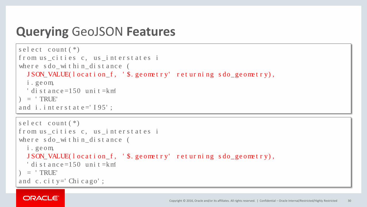
Querying GeoJSON Features
Confidential – Oracle Internal/Restricted/Highly Restricted 30
select count(*)from us_cities c, us_interstates iwhere sdo_within_distance (
JSON_VALUE(location_f, '$.geometry' returning sdo_geometry),i.geom,'distance=150 unit=km'
) = 'TRUE'and i.interstate='I95';
select count(*)from us_cities c, us_interstates iwhere sdo_within_distance (
i.geom,JSON_VALUE(location_f, '$.geometry' returning sdo_geometry),'distance=150 unit=km'
) = 'TRUE'and c.city='Chicago';
Copyright © 2016, Oracle and/or its affiliates. All rights reserved. |
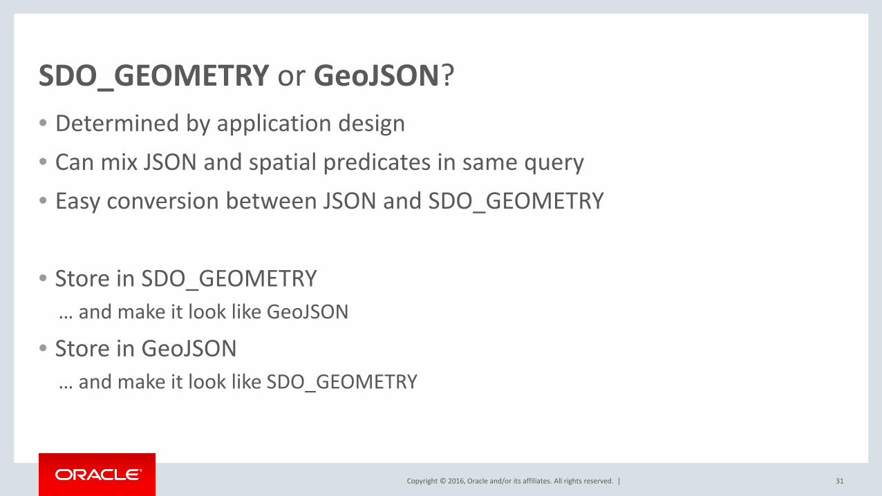
SDO_GEOMETRY or GeoJSON?• Determined by application design• Can mix JSON and spatial predicates in same query• Easy conversion between JSON and SDO_GEOMETRY
• Store in SDO_GEOMETRY… and make it look like GeoJSON
• Store in GeoJSON… and make it look like SDO_GEOMETRY
31
Copyright © 2016, Oracle and/or its affiliates. All rights reserved. |
Oracle REST Data Services
Confidential – Oracle Internal/Restricted/Highly Restricted 32
Copyright © 2016, Oracle and/or its affiliates. All rights reserved. |
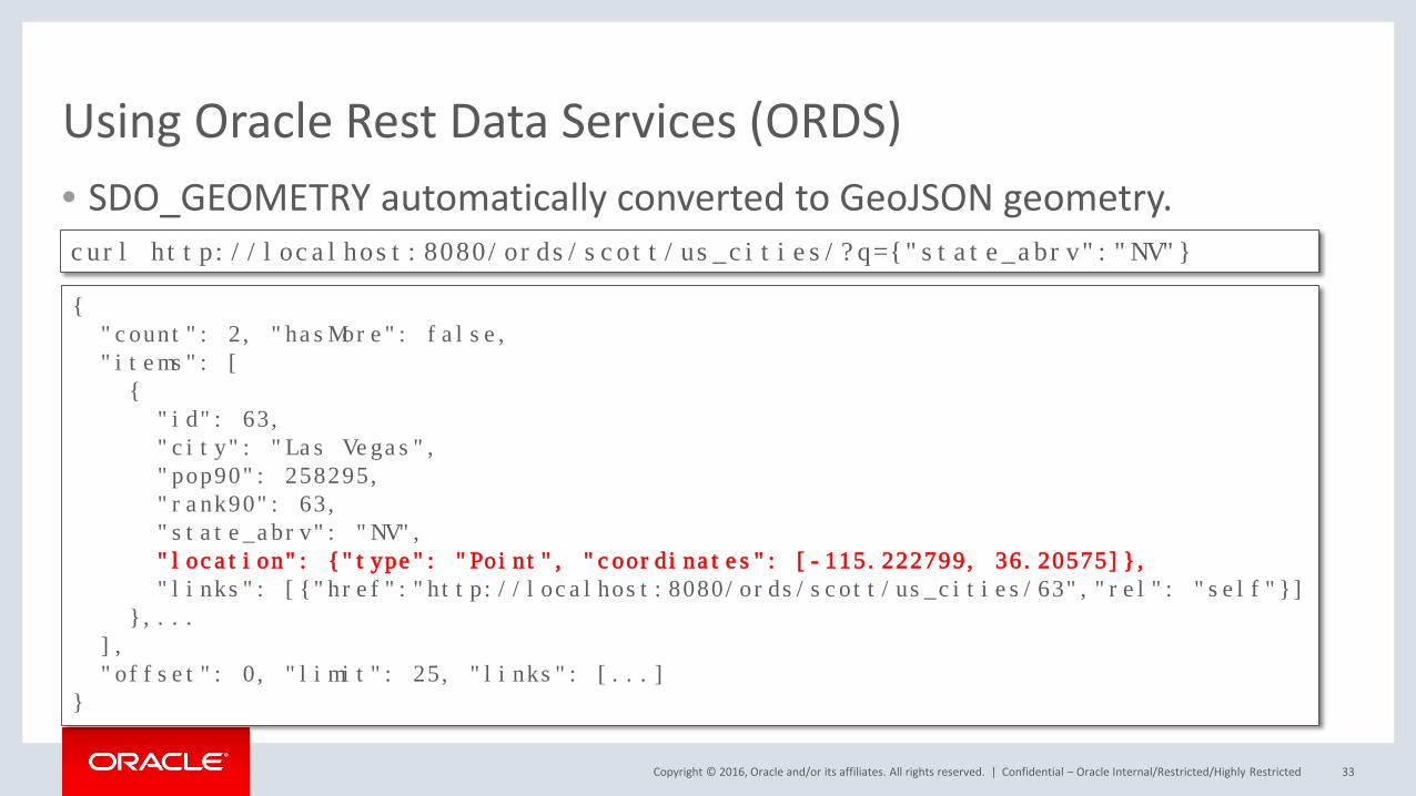
Using Oracle Rest Data Services (ORDS)• SDO_GEOMETRY automatically converted to GeoJSON geometry.
Confidential – Oracle Internal/Restricted/Highly Restricted 33
{"count": 2, "hasMore": false,"items": [{"id": 63,"city": "Las Vegas", "pop90": 258295,"rank90": 63,"state_abrv": "NV","location": {"type": "Point", "coordinates": [-115.222799, 36.20575]},"links": [{"href":"http://localhost:8080/ords/scott/us_cities/63","rel": "self"}]
},...],"offset": 0, "limit": 25, "links": [...]
}
curl http://localhost:8080/ords/scott/us_cities/?q={"state_abrv":"NV"}
Copyright © 2016, Oracle and/or its affiliates. All rights reserved. |
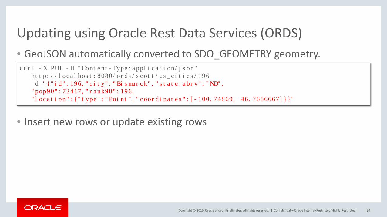
Updating using Oracle Rest Data Services (ORDS)• GeoJSON automatically converted to SDO_GEOMETRY geometry.
• Insert new rows or update existing rows
Confidential – Oracle Internal/Restricted/Highly Restricted 34
curl -X PUT -H "Content-Type:application/json"http://localhost:8080/ords/scott/us_cities/196 -d '{"id":196,"city":"Bismarck","state_abrv":"ND", "pop90":72417,"rank90":196, "location":{"type":"Point","coordinates":[-100.74869, 46.7666667]}}'
Confidential – Oracle Internal/Restricted/Highly Restricted 35
36
Copyright © 2016, Oracle and/or its affiliates. All rights reserved. |
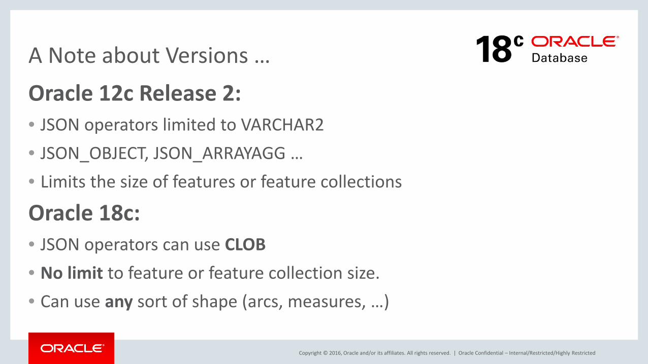
A Note about Versions …Oracle 12c Release 2:• JSON operators limited to VARCHAR2• JSON_OBJECT, JSON_ARRAYAGG …• Limits the size of features or feature collections
Oracle 18c:• JSON operators can use CLOB• No limit to feature or feature collection size.• Can use any sort of shape (arcs, measures, …)
Oracle Confidential – Internal/Restricted/Highly Restricted
Copyright © 2016, Oracle and/or its affiliates. All rights reserved. |
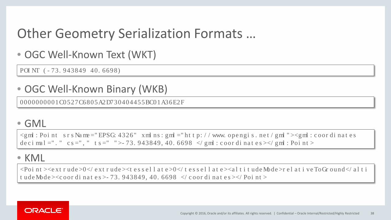
Other Geometry Serialization Formats …• OGC Well-Known Text (WKT)
• OGC Well-Known Binary (WKB)
• GML
• KML
Confidential – Oracle Internal/Restricted/Highly Restricted 38
POINT (-73.943849 40.6698)
0000000001C0527C6805A2D730404455BC01A36E2F
<gml:Point srsName="EPSG:4326" xmlns:gml="http://www.opengis.net/gml"><gml:coordinatesdecimal="." cs="," ts=" ">-73.943849,40.6698 </gml:coordinates></gml:Point>
<Point><extrude>0</extrude><tessellate>0</tessellate><altitudeMode>relativeToGround</altitudeMode><coordinates>-73.943849,40.6698 </coordinates></Point>

Copyright © 2016, Oracle and/or its affiliates. All rights reserved. |
Engage with the Spatial and Graph SIG Promotes interaction and communication to drive the market for spatial technology and data
Members connect and exchange knowledge via online communities and at conferences and events
• Talk with us at the Summit! •
• Join us online• tinyurl.com/oraclespatialcommunity• Search for “Oracle Spatial and Graph Community”
• Contact us: [email protected] @oraspatialsig
Morning ArrivalsTues & Wed 7:45-8:30 a.m. Registration Area
Birds of a Feather LunchWednesday
12-1pmAuditorium
Receptions Tues & Wed eveningsSpatial Table, lobby
Copyright © 2016, Oracle and/or its affiliates. All rights reserved. | 40
ALBERT GODFRINDSpatial Solutions ArchitectLocation and Geospatial Services
Greenside 400 av. Roumanille - BP 30906906 Sophia-AntipolisFrance
phone +33 4 93.00.80.67mobile +33 6 [email protected]://www.oracle.com/
Oracle Corporation

Copyright © 2016, Oracle and/or its affiliates. All rights reserved. | Confidential – Oracle Internal/Restricted/Highly Restricted 41