using geographic information systems for pre-incident …
TRANSCRIPT

Geographic Information Systems 1
Running Head: GEOGRAPHIC INFORMATION SYSTEMS AS DATA NEXUS
Using Geographic Information Systems for Pre-Incident Planning
David L. DeMarco
Everett Fire Department, Everett, Washington

Geographic Information Systems 2
Certification Statement
I hereby certify that this paper constitutes my own product, that where the language of others is set forth, quotation marks so indicate, and that appropriate credit is given where I have used the language, ideas, expressions, or writings of another.
Signed: _________________________________________

Geographic Information Systems 3
Abstract
Emergency incident size-up is a critical function performed by all fire officers. Size-up begins
the moment crews leave the station and the more information available the better the size-up will
be. Unfortunately many firefighters still lose their lives due to inadequate size-ups. The
problem is the fire service collects and stores volumes of data that would be useful to emergency
responders for size-up: NFIRS data, NEMSIS data, inspection history, and special hazard
information collected over years of experience, yet rarely is this data available during emergency
response. The purpose of this Applied Research Project is to show that a Geographic
Information System (GIS) acts as a nexus for all these data types and displays them graphically
on digital maps familiar to firefighters. By using fire service GIS layers responders are able to
create better incident action plans and share these plans more effectively amongst other
responders. The descriptive method of research was used to determine what data was collected
and stored by the Everett Fire Department, other city departments, and neighboring departments,
and to determine if a GIS would easily display key pre-incident plan and special hazard
information while responding. Procedures included an extensive literature review and
compilation of NFPA 1620 pre-incident planning data points. Procedures also included
interviews with subject matter experts and inventories of existing Everett Fire Department data
sets compared against NFPA recommendations. Results determined GIS software is the ideal
medium for displaying a summary of key NFPA 1620 information. This ARP recommends the
creation of fire service GIS layers for display on mobile data computers for use during
emergencies.

Geographic Information Systems 4
Table of Contents
Certification Statement ................................................................................................................... 2
Abstract ........................................................................................................................................... 3
Introduction ..................................................................................................................................... 6
Background and Significance ......................................................................................................... 6
Literature Review.......................................................................................................................... 12
Procedures ..................................................................................................................................... 19
Results ........................................................................................................................................... 21
Table 1 .......................................................................................................................................... 24
Discussion ..................................................................................................................................... 25
Recommendations ......................................................................................................................... 28
Table 2 .......................................................................................................................................... 30
Figure 1 ......................................................................................................................................... 32
Figure 2 ......................................................................................................................................... 33
Figure 3 ......................................................................................................................................... 33
Figure 4 ......................................................................................................................................... 34
Figure 5 ......................................................................................................................................... 34
Figure 6 ......................................................................................................................................... 35
Reference List ............................................................................................................................... 36

Geographic Information Systems 5
Appendix A ................................................................................................................................... 39
Appendix B ................................................................................................................................... 42
Appendix C ................................................................................................................................... 43

Geographic Information Systems 6
Introduction
Effectively mitigating any emergency requires emergency responders to create a mental
snapshot of a dynamic emergency event, known as a “size-up”, and then formulate and
implement intervention plans that will bring the event to a safe conclusion. This technique is not
always simple, evidenced by the eighty-two (National Fire Protection Association [NFPA],
2010) firefighters who gave their lives intervening in emergencies nationwide in 2009. Fire
departments everywhere commit enormous resources collecting data of all kinds, much of which
would be useful in pre-assembling these size-ups before they are needed, yet this rarely occurs.
The purpose of this Applied Research Project (ARP) is to determine what data is available to the
Everett Fire Department (EFD) which could be useful during emergency response and determine
an effective way of utilizing it from the field.
The descriptive method of research was used to prepare this ARP. The research
questions addressed were: What data is currently being collected and stored by the EFD? What
data would be useful that is not being collected? What data is currently being collected by other
city departments, utilities, or neighboring jurisdictions that may be of use to the EFD? What
capability does Geographic Information Systems (GIS) software offer as a nexus for display of
useful data? What functions does GIS software offer which would assist with emergency
response? What hardware changes would be required to effectively utilize GIS software from
the field? What barriers stand against effective GIS utilization?
Background and Significance
The City of Everett is populated by approximately 110,000 residents over forty-two
square miles of land within Snohomish County, Washington. Everett is located approximately
thirty miles north of Seattle on the Interstate 5 corridor and comprises the northern end of the

Geographic Information Systems 7
Puget Sound metropolitan region containing the cities of Seattle, Tacoma, Bellevue, and Everett
among others. The region is home to 1.5 million residents. The City of Everett is old by west
coast standards, incorporated in 1892 and is the seat of Snohomish County government. As an
early western terminus of the Pacific Railroad, Everett exported lumber and lumber products to
the United States and the world for the bulk of its first sixty years. Fantastic mill fires routinely
occurred on Everett’s waterfront and contributed to an early, rich firefighting tradition. Modern
Everett is home to several multinational corporations including the Boeing Company’s primary
assembly factory for the 747, 767, 777, and 787 commercial aircraft. In addition to these and
other private sector employers the City of Everett is also home to Naval Station Everett,
homeport to the nuclear-powered aircraft carrier U.S.S. Abraham Lincoln and several other ships
from her battle group.
The Everett Fire Department is a career fire department comprised of 177 uniformed
personnel providing all-hazard emergency services including fire response, emergency medical
services and transport including basic and advanced life support, technical rescue, hazardous
materials technician-level response, fire code plan review, fire code inspection and enforcement,
and a variety of supporting services. On a daily basis the Everett Fire Department staffs seven
fire engines, one ladder company, three paramedic units, two basic-life support units and a
battalion unit. Every apparatus in the fleet is equipped with a mobile data computer (MDC) and
900MHz modem for communication with CAD software. Each year the department answers an
ever-increasing number of calls for service; in 2009 there were over 18,500 alarms. As is the
case with most modern departments, over eighty percent of those requests were for medical
assistance.

Geographic Information Systems 8
During medical alarms employees gather information on patient care reports (PCRs).
The information gathered includes those data points recommended by the National EMS
Information System (NEMSIS) as well as local data including computer aided dispatching
(CAD) incident identifiers and tracking times, and information pertinent for patient transport
billing if necessary. PCRs are returned to the stations and the information gathered from the
alarm is combined with the CAD data in a Fire Data Management (FDM) database and stored by
the department. Stored EMS data is not accessible to responders during subsequent alarms.
For fire responses and other non-medical requests for service the Everett Fire Department
collects fire incident information on paper and combines it with CAD data upon return to the fire
station, where it is entered into FDM. The information collected during these non-medical
responses is National Fire Incident Reporting System (NFIRS) data and stored in a database by
the department. Stored NFIRS response data is not available to responders during alarms.
The Everett Fire Department performs annual code-compliance inspections of all
commercial occupancies within its jurisdiction using the International Fire Code, 2006 edition.
Four full-time inspectors handle the complex, high-hazard occupancies and fire suppression
officers are assigned all routine commercial and multifamily occupancies within the city. During
the course of those inspections the department records vast quantities of data about commercial
occupancies including suppression systems data, detection systems data, alarm panel locations,
and key box inventories. Beginning in 2010 data from inspections is being entered into a
relational database via software called OneStep, which is not accessible from the field during
emergency response.
During the course of plan review for new commercial structures the department is
provided detailed architectural plans of all developments. These plans are often provided both
Geographic Information Systems 9
on paper and digitally, and fire department inspectors are on-site during most development to
check on code compliance as construction progresses. The department does not store electronic
plans provided by developers and makes no effort to store any plans once the construction final
is approved. Responders have no access to plans data during emergency response.
The department is routinely provided with information from various city departments
regarding the status of community resources: Street closures, road construction, water main
closures, hydrants placed out-of-service, unstable driveways and addresses law enforcement has
deemed unsafe, etc. Other public organizations often provide important data including public
health notices or notices of reportable chemical quantities stored at the Port of Everett. All these
pieces of data are evaluated by Chief Officers and disseminated to the employees via two paths:
Information bulletins and safety bulletins. The path chosen is based on the potential impact to
firefighter safety. Both information bulletins and safety bulletins are distributed to the fire
stations on paper and posted with an expiration date, if applicable; employees are required by
policy to visit these notices every morning at the start of shift. Neither information bulletins nor
safety bulletins are available to responders during alarms and recalling the various notices and
safety information while responding can be challenging at best.
In 2006 the department recognized the value of accurate site-plans for pre-incident
planning. Two employees were assigned the herculean task of surveying commercial properties
and creating simple site-plans that identify fire suppression features, utilities, key box locations,
and in the case of multi-building complexes, the building numbers and private roadway
characteristics. These site plans were completed for 175 addresses and are carried on apparatus
both on paper and as electronic Portable Document Format (PDF) files hyperlinked in a sortable
Excel worksheet. These site plans are routinely accessed by employees for incidents of all types

Geographic Information Systems 10
for site specific information. Unfortunately department priorities have not allowed the ongoing
creation of new site plans or maintenance of the existing plans. There are still over 4,000
commercial and multifamily occupancies in the city which warrant site-plan information but
have none available, and many of the existing plans now provide information that is out of date.
None of the site-plans are linked in any way to OneStep inspection data so valuable current
inspection history and owner/occupant information is not accessible via site-plans. Site plans for
single family residences have not been attempted despite the occasional need for very serious
safety notifications.
Finally, department members collect but do not record some of the most valuable data.
Field experience during actual alarms exposes employees to small but critical pieces of
information that can make the difference between successful emergency mitigation and
catastrophe. So called “street smarts” said to come from experience and only passed down
verbally is useful and recordable information: Knowledge of dogs that bite, hoarder homes
found on aid calls, places the apparatus won’t fit, and the myriad of other details that are handed
down from one crew to the next. Unfortunately Everett, like most departments facing the
challenge of twenty-four hour staffing, often reassign personnel, and so in the dark of night
employees regularly find themselves having to re-learn information other employees have
already learned. It is shameful that in most cases the valuable information which could have
saved time or made the difference between success and failure has already been learned by some
members of the department but was not institutionalized. The difficulties with any pre-planning
program is taking all these sources of raw data, compiling them, keeping them current, and then
distilling the important information into an at-a-glance format useful to first responders.

Geographic Information Systems 11
When considering the enormity of the information available to the department and
recognizing the time constraints placed on first responders during emergencies it becomes
necessary to look for a way to sort and filter it in a meaningful way. The fire service’s tool of the
future can be found in its past: The map. Whether it is an address contaminated with active
tuberculosis, an out-of-service hydrant, or a building with a basement, they all occupy a
geographical location which can be tied to a map via geospatial coordinates and depicted with a
symbol. The fire service has long experience reading maps and the transition to digital mapping
is well underway. More important than the digitization of the map however, is the evolution of
Geographic Information Systems (GIS) which allow information to be overlaid and viewed upon
a map in layers and is updatable in real time.
Snohomish County has undertaken the process of upgrading its computer aided
dispatching (CAD) software. The new version, supplied by a software vendor called New World
Systems, will be active on all responder MDCs by June 2011 and includes a GIS viewer. The
intent of New World Systems is to use the GIS viewer for the purpose of automated response
route planning, (Wollenweber, 2010) but there are far more valuable purposes for GIS in the fire
service. If the variety of useful data already mentioned can be related to a location on the map, it
can be inputted into the GIS and displayed on the MDC while responders are en-route to an
emergency.
Visualization of all these data types on GIS layers will allow the Everett Fire Department
to better meet the United States Fire Administration’s current goals. Objectives of all five goals
would be addressed should the Everett Fire Department be able to access these various data sets
during emergency responses. Prevention was the focus of Executive Analysis of Community
Risk Reduction and the systematic institutionalization and utilization of all the information
Geographic Information Systems 12
collected by the Everett Fire Department is a potent risk reduction strategy. It would expand the
use of modern data and information analysis in planning and preparedness. It would improve our
decision making skills and improve our service delivery, improving our professional status.
Finally it would improve our business systems and processes for the benefit of both the
community at large and the employees serving them.
Literature Review
The National Fire Protection Association (NFPA) contributes a great deal to the standards
set for fire department data collection. The vast majority of data points suggested for collection
are intended for use in fire department post-performance analysis, rather than for recall during
emergency response. The Fire Protection Handbook (NFPA, 1998) discusses and clearly
recognizes the value of fire department information systems and lists useful managerial decisions
which are made easier through data analysis: Positioning of capital resources, dispatching,
human resources, budgeting, fleet maintenance, communications, permitting, and pre-fire
planning. Other than the mention of “pre-fire planning” there is little discussion over several
chapters for using information systems while mitigating emergencies. The NFPA does,
however, recognize the information systems and stored data of a fire department as “crucial” to
the success of the department. (NFPA, 1998, p. 10-45)
Further investigation of the NFPA’s intent on pre-incident planning reveals NFPA 1620:
Standard for Pre-incident Planning. (NFPA, 2010) In 2010 the NFPA updated their stance on
pre-incident planning and NFPA 1620 is now a standard, rather than simply a recommended
practice. The NFPA makes it very clear that pre-incident planning should include a standard
dataset, and offers a sample data collection form for that purpose. The scope and complexity of
pre-incident plans are left for the local authority to determine. NFPA 1620 also states that pre-
Geographic Information Systems 13
incident plans shall be available to incident commanders both during and after emergency
response. The recommended dataset for pre-incident planning is vast, and could be displayed in
a variety of ways. For example, building construction type and features, or the facility
management and utility systems could be described both graphically and textually.
Crucially relevant to this ARP is NFPA 1620, Chapter 9 where it is required that the pre-
incident plan, or “a summary of its key elements” [italics added] be available to responders both
while responding to, and operating upon an emergency incident. Unfortunately, the NFPA does
not identify which data points among the volume of suggestions, are considered key. This
critical decision is left to the local authority. Additionally, the NFPA does not identify a specific
medium with which to deliver pre-incident plans to users; in fact methods of delivery are not
discussed and thus left to the local jurisdiction as well.
The United States Fire Administration (USFA) manages the National Fire Incident
Reporting System (NFIRS) and is responsible for determining the data points collected by
NFIRS. In their 2009 report to Congress, the USFA admits the NFIRS dataset is out of date and
“in need of modernization”. (United States Fire Administration [USFA], 2010) When discussing
the useful purposes of NFIRS data the USFA lists its value for planning management but makes
no mention of NFIRS data use during responses. The USFA advertises the NFIRS system as a
national effort to assemble fire response data for use by local and national officials in
understanding the national fire problem. (USFA, 2007)
In 2009 the USFA began a NFIRS enhancement project that includes four distinct phases
with the intent of making NFIRS data both more relevant and more accessible by client
departments. Part four of that project is the enhancement of a web-based user interface to the
NFIRS data and includes a cryptic reference to the addition of GIS services and improved
Geographic Information Systems 14
administrative applications. This report to Congress briefly recognizes the value of GIS in fire
department management planning but makes no mention of the possible use of GIS for tactical
purposes. (USFA, 2010)
Initial fire scene size-up is widely discussed by fire service professionals as critical to the
successful, safe mitigation of emergency incidents. Chief Michael Walker, (Oklahoma City,
OK) asserts that the systematic size-up of emergency incidents begins while en-route to the
alarm. “The decisions the first-arriving officer makes on a fire scene are critical to the success of
that operation.” (Walker, 2009) This sentiment is repeated throughout trade journals and articles
as well as nationalized incident management materials.
When firefighters fail to accurately share a size-up, lives may be lost. The 1994 Mary
Pang Warehouse fire in Seattle, WA claimed the lives of four firefighters. During this event the
incident commander and safety officer were operating on opposite sides of the structure and the
IC was not aware there was a basement. The failure in this case was between the incident
commander and his safety officer and divisions: None of them recognized that they were all
seeing a different size-up image. Had a pre-incident plan been available which included
structural features like the presence of a basement, or pictometry views of all four sides, the
miscommunication may have been avoided and lives may have been saved. Critical issues
identified in the USFA technical analysis of this tragedy (USFA, 1995) include the finding that
command officers were faced with a very difficult size-up due to geography and multiple
renovations. An additional finding that contributed to the loss was the lack of a pre-incident plan
for the structure. Finally, Seattle Fire had warned their crews that the Pang warehouse was the
target of arson threats but that special hazard information was not available to responders while
responding.

Geographic Information Systems 15
Information management is cited by the USFA investigator as a contributing factor in the
loss of life. The Mary Pang investigator recognized that:
The ability of an Incident Commander to make an appropriate risk assessment is
necessarily based on the information that is available at any point in time and the Incident
Commander’s ability to process that information. The Incident Commander must use the
available information in an expedient manner to direct the early stages of an operation
and then continually update the information. (USFA, 1995, p. 21)
The lack of accurate, expedient information during emergency operations is a recurring theme in
the study of fire incidents, and particularly those fire incidents resulting in firefighter fatalities.
The volume of information available on the Pang warehouse prior to the arson fire would have
been impossible to commit to memory. Only an accurate pre-incident plan could have contained
it all.
The National Institute for Occupational Safety and Health (NIOSH) studies trends in
firefighter deaths and investigates workplace factors which may have contributed to occupational
injuries and fatalities. NIOSH investigated the Charleston, N.C. structure fire at the Super Sofa
facility in which nine Charleston firefighters lost their lives as a part of the NIOSH Fire Fighter
Fatality Investigation and Prevention Program. Among the preventative strategies for the
future, NIOSH identifies the value of an initial size-up, as well as the need for ongoing pre-
incident planning within fire jurisdictions. These factors are among those cited which
contributed to the loss of life in Charleston and will prevent future firefighter fatalities. (National
Institute for Occupational Safety and Health [NIOSH], 2009) With so many fire service
leadership organizations recognizing the need for an accurate size-up and the value of pre-

Geographic Information Systems 16
incident planning the question becomes one of organizational willpower, as the sheer volume of
work may appear overwhelming.
NFPA 1620 has identified the information needed for an accurate pre-incident plan and
NFPA 170: Standard on Fire Safety Symbols (NFPA, 2009) provides the fire service with the
legend necessary for drafting them uniformly. However, these two standards create a volume of
textual and graphical information so vast it becomes cumbersome, at best, to manage and nearly
impossible to utilize at-a-glance while responding to an emergency. Technology must be used to
cull key information and make it readily accessible and comprehensible for responders.
The USFA defines a Geographic Information System as a “computer-based system used
to capture, store, retrieve, manipulate, analyze and display spatial information”. (USFA, 2003)
Virtually all data of interest to the fire service can be related to a specific place, and numerous
sources are beginning to recognize the value of digitizing and displaying it graphically via GIS.
In order for this to be possible, a GIS foundation must first be built. A comprehensive GIS will
include base layers of information including land-use, transportation, zoning, vegetation,
residential and commercial areas, standing water, flowing water, elevation and terrain to name a
few. (ESRI) Additionally, satellite imagery and oblique-angle images can be linked to the base
map allowing either a bird’s-eye view or a side view of all geographic features as offered by
Pictometry International. (Pictometry International, 2010)
The National Alliance for Public Safety GIS (NAPSGIS) has identified multiple uses for
GIS in the following fire department service areas: Planning, preparedness, response and
recovery. Preplanning is a key component of providing preparedness and field intelligence
gathering is a key component in providing emergency response, both of which are improved with
GIS. The Alliance also identifies twenty other administrative and managerial uses for GIS in the

Geographic Information Systems 17
fire services that are of great benefit but outside the scope of this ARP. (National Alliance for
Public Safety GIS) NAPSGIS advises that all aspects of emergency response can and should be
addressed by GIS. In fact they recommend field personnel carry portable global positioning
system (GPS) enabled computers with optical input for uploading of incident data directly from
the scene for real-time large-scale event mitigation. (National Alliance for Public Safety GIS,
2007)
Mike Price, geologist and author for ArcUser magazine has written extensively on the
creation of GIS for the fire service. Price asserts that an accurate and reliable street network
model is the critical GIS base layer for the fire service. From the street map a variety of other
data can be overlaid and then related to fire service resources. Everything from response times
to graphical depictions of NFIRS and NEMSIS data can be overlaid to show chief officers,
politicians, and community members areas which may be underserved or to demonstrate peak
demand. For the responder en-route to an emergency incident, GIS offers the ability to find both
the location of their apparatus and the location of the incident to plot a street route between those
points. If street data is kept current with street closures or weight limitations the GIS can
recommend a route that avoids those points. (Price, 2009)
Beyond an accurate street layer, Price identifies five other essential base layers for public
safety GIS systems. (Price, 2010) He recommends a cadastral layer, which is a map layer
delineating all property boundaries within a jurisdiction. When combined with assessor data it
provides both a geometric element (property shape) and a text element (owner information,
parcel identification numbers, etc.). Orthoimagery is the next recommended layer, which is
aerial or satellite imagery of the jurisdiction. Orthoimagery ties the cadastral and transportation
information together allowing users to recognize familiar terrain features. Administrative units,

Geographic Information Systems 18
including jurisdictional boundaries, urban growth areas, and public right-of-way are the next
recommended layer with elevation and hydrography as the final two necessary layers.
With these essential six layers Price asserts public safety managers can begin to use GIS
for all the potential purposes identified by the National Alliance for Public Safety GIS. Once the
essential layers are fully developed, Price identifies numerous types of special data that would be
useful to the fire service during emergency response: Fixed and portable fire protection
facilities, water supply infrastructure, site specific hazards, industrial facility features, and
hazardous materials storage. (Price, 2010)
For public safety to begin utilizing GIS, the NAPSGIS recommends the formation of a
geospatial team made up of subject-matter experts from all contributing fields as well as
technical expertise from the GIS field. (National Alliance for Public Safety GIS, 2007) The
number of individuals required for a geospatial team will depend on the scope and volume of
data involved and may include representatives from planning departments, utilities, police, and
the fire service as well as a GIS technician. However, in the long run the success of a fire service
GIS will depend on its comprehensibility and ease of navigation for the people who access it
every day.
Users do not need to understand the technical workings of a GIS, but they must be able to
use the interface and interpret the geospatial data. New users of GIS systems often struggle with
the volume of data and are overwhelmed by the possible combinations of information offered by
mature GIS. Managers who implement GIS incrementally have had greater success in slowly
adapting a workforce culture to include this new technology. (Innes & Simpson, 1993)
Knowledge of a firefighter’s service area used to be carried in the company officer’s
mind. Today the scope and complexity of any given service area is beyond the limit of a typical

Geographic Information Systems 19
fire officer’s memory. A vast amount of data can be assimilated in a GIS and displayed
graphically on a city base map similar to maps of the early 20th century. The difference is
modern GIS maps are as fluid and reactive as the real world environment which they depict.
Real-time situational awareness and a size-up image that is shared via GIS among
multiple responding fire officers allows firefighters to visualize the same images, make better
decisions, and put a mitigation plan in action sooner and with greater effect. On the fire ground
there is no substitute for good information; developing and effectively utilizing a GIS is the most
effective way to store and quickly recall the information needed to make critical decisions and
accurate risk assessments. (St. John, 2007)
Orange County, California has recognized the need for GIS and successfully created a
“data warehouse” which includes information from old paper pre-incident plans, maps, and files
and combined those with historical response information and dynamic data sources like weather
service, traffic, and earthquake sensing stations. The combination of all these sources in a GIS
has led to better decision making in the field and more efficient use of emergency resources in
one of the largest fire service organizations in the nation. (Theodore, 2009)
Procedures
The descriptive method of research was used to prepare this ARP. An interview with
Everett Fire Chief Murray Gordon on this topic occurred March 6, 2010, allowing the author to
determine what, if any GIS capability the Everett Fire Department may already have. The Fire
Chief also provided contact information for a City of Everett GIS technician in the utilities
department and contact information for a New World Systems GIS specialist located in Troy,
Michigan. (Gordon, 2010) Brent Linder is the City of Everett Utilities Department GIS
specialist; an interview with Mr. Linder occurred on July 12, 2010 in his office at the utilities

Geographic Information Systems 20
department: 3200 Cedar Street, Everett, WA, 98201. A telephone interview was conducted with
Britt Wollenweber, GIS Specialist for New World Systems, on July 22, 2010 connecting from
his office in Michigan. An interview with Everett Fire Marshal Richard Robinson occurred on
July 28, 2010 at Fire Station #1, 3619 Rucker Ave., Everett, WA 98201 to discuss the fire
marshal’s office electronic recordkeeping capability. A follow-up interview with the Fire
Marshal was conducted to determine what political and financial barriers might stand in the way
of effective utilization of GIS in Everett.
During the course of the interview with Linder he described the work done to date by the
City of Everett in GIS base mapping and it is extensive. He referred to a City of Everett intranet
location which could access the vast majority of City of Everett owned GIS data from any city-
networked terminal. The internal web portal location is: http://arcgisweb. (Linder, 2010) This
site is an Esri-powered web based GIS explorer and allows users to view the various layers of
data maintained by the Everett Utilities Department in a read-only format. It also allows users
with permission to access City of Everett owned Pictometry images. This tool was studied
extensively as a means for determining the existing GIS data owned by the City of Everett.
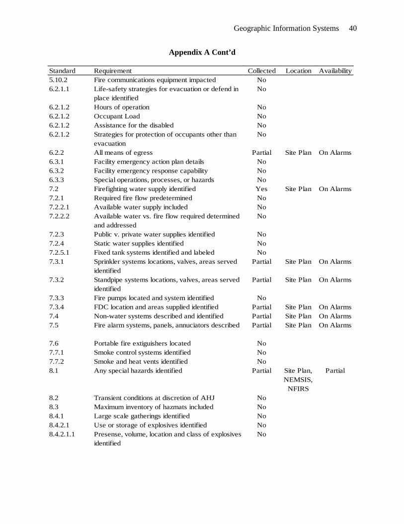
A table of data recommended by NFPA 1620 was created. (Appendix A) The 1620 pre-
incident plan data collected by the Everett Fire Department through NFIRS reporting, site plans,
OneStep, or NEMSIS was inventoried and added to the table, with notation of where the data is
stored. Finally, the EFD data that is stored was labeled as to whether or not it was accessible by
responders during emergency incidents. (Appendix A) A list of NFPA 1620 recommended
practices for pre-incident plans was created and compared to the existing site-plan program in
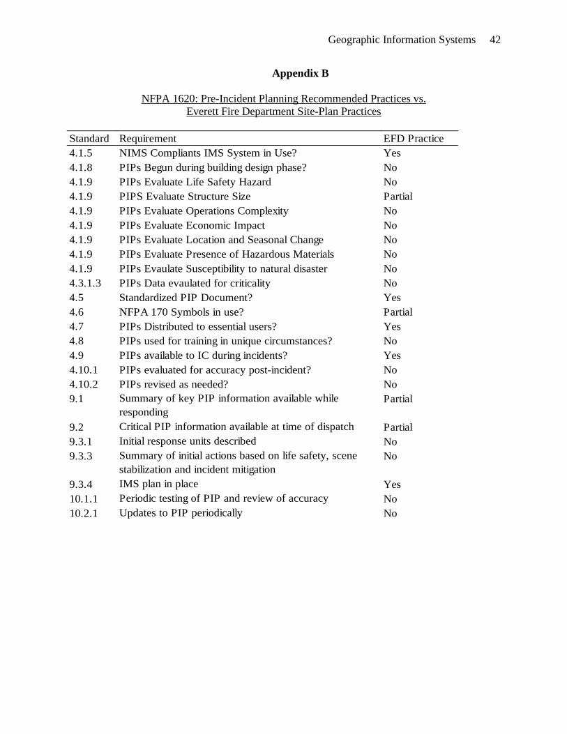
use by the Everett Fire Department. (Appendix B)

Geographic Information Systems 21
An inventory of the GIS layer data that has been created by other City of Everett
departments was created, and layers of use during emergency response were labeled. (Appendix
C) To determine the capability of Everett Fire Department units to utilize and display GIS
information in the field an inventory of MDC specifications was created and compared to the
minimum hardware requirements for New World Systems GIS viewer. (Table 1)
Results
What data is currently being collected and stored by the Everett Fire Department, and
what data would be useful that is not being collected? Study of the information being collected
finds an accurate base of response data including NEMSIS and NFIRS data points as well as
response time information being kept by CAD dispatching software. All three of these datasets
are compiled by members as they return to the station after alarms and entered manually into an
FDM database. All FDM data is stored and maintained on an enterprise server by the City of
Everett Information Technology Department. Additionally, in 2010 the Everett Fire Department
began electronic storage of code-compliance inspections in another unique database via software
called OneStep marketed by One Step Information Systems, Parksville, British Columbia,
Canada.
The department’s existing site plans are stored on both paper and electronic media. The
electronic site plans exist as artwork files (images) and are available as PDFs on the local hard
drives of each MDC. The data points recommended for pre-incident planning in NFPA 1620 and
currently collected by NEMSIS, NFIRS, CAD, OneStep, or proprietary site plans are listed in
Appendix A. Appendix A also indicates whether each particular data point is accessible via
MDC during responses. Assembling this information makes clear which NFPA 1620 data is
already present in the EFD system and what data is needed but not currently being collected.

Geographic Information Systems 22
Of particular interest is NFPA 1620 8.1: Special Hazards. The department collects
special hazard information from a wide range of sources and then stores it in a variety of
locations. For example, the department may receive notice of a location with a patient suffering
active tuberculosis and post a warning for such via information bulletin. Another example is a
notification from the building department of “Do Not Enter” status, which might be caused by a
variety of problems including structural integrity or legal dispute with the building owner.
Members on alarms also collect special hazard information and pass it verbally to other crews
but make no formal record of it, such as the known location of a hoarder home located during a
medical incident. The lack of accessible special hazard information during emergency response
places firefighter lives at greater danger.
What data is being collected by other city departments and neighboring jurisdictions that
may be useful to responders during alarms? Other city departments are miles ahead of the fire
department in the collection and display of data pertinent to their area of service. The Everett
utilities department is the GIS coordinating department for the remainder of the city. GIS
software is used by the utilities department to display data graphically, geo-located in its proper
place in proper scale overlaid on map layers. Utilities have a wide range of data already on file
in GIS format, hardware, and technical expertise which would be of great value to the fire
department. (Linder, 2010) The scope of all GIS layers managed by the Utilities Department is
listed in Appendix B.
The street department is currently using a handheld device called a Trimble Juno to geo-
locate every street sign in the city, and they are noting its type, age, condition, and the direction it
is facing. The device is a small GPS enabled handheld that will upload geo-coordinates as well

Geographic Information Systems 23
as pre-programmed items into the street department’s database. Once entered, the street signs
are displayed by GIS viewer in their location with their attributes. (Linder, 2010)
The two adjacent fire districts do not use GIS for response to alarms. Both Snohomish
County Fire District 1, population 148,000, and the Marysville Fire District, population 60,000
use some GIS tools for planning purposes. Neither have any pre-incident planning layers
available for the GIS viewer arriving with New World. Puget Sound Energy, the local natural
gas utility, uses GIS software for mapping of their distribution lines in the City of Everett; an
agreement to share that data would have to be struck.
What capability does GIS offer as a nexus for the various types of useful data, and what
functions will GIS offer for use during emergency response? Price says GIS software will allow
users to view institutional data that can be correlated to a specific location. (Price, 2010) GIS
software may be terribly complex at its root level, but with the arrival of Arc/View GIS a GIS
specialist is no longer required for most functions. (Bloom, 1998) The ability of GIS software to
graphically display geo-located data makes it the obvious solution for quick and easy display of
key NFPA 1620 information. It is particularly well suited to display special hazards, as they all
have, by definition, a geographic location. GIS is the only plausible nexus for all the different
data types collected by, or of interest to the Everett Fire Department. The imminent arrival of
New World Systems software will provide the needed viewer for interpreting GIS data.
Linder explained the value of inserted hyperlinks within the GIS. Inserted hyperlinks
allow information from other databases to open in new windows while the GIS map continues to
run. Hyperlinks to images are also possible where up close imaging is needed of specific details,
such as pipe valves or chemical storage facilities. Existing EFD site plans saved as PDF’s or

Geographic Information Systems 24
architectural drawings submitted for plan review could also be inserted into a GIS as hyperlinks.
(Linder, 2010)
What hardware changes are required to implement effective GIS? The minimum
hardware requirements needed to run New World Systems software, including the GIS viewer
are listed in Table 1. (Wollenweber, 2010) Existing MDCs are adequate for running New World
software, with the notable exception of GPS enabled cellular broadband aircards. The cellular
aircard is part of the county-wide agreement between New World and all participating
jurisdictions and will be installed on all MDCs prior to the “go live” date of June 2011. There
will be significant costs for the associated aircard data contracts with private cellular networks.
The Everett Fire Department has already committed to the cost of this upgrade. (Gordon, 2010)
Table 1
MDC Hardware Requirements vs. Existing MDCs
New World Mobile Data Computer Requirements EFD MDC Compliance
Intel Core 2 (Centrino) Processor Yes
Windows Vista Business with XP Downgrade Option Yes
2+ GB System Memory Yes
80+ GB Hard Drive Yes
13.3” LCD Display (Touch screen optional) Yes
Backlit Keyboard No
DVD-ROM Yes
Integrated, GPS Enabled Cellular Modem/Aircard No
What barriers stand against effective GIS utilization? A frank discussion with the Fire
Marshal identified only a few barriers to using GIS to its full benefit. A GIS viewer is already

Geographic Information Systems 25
forthcoming with New World Systems, and the costs associated with hardware upgrades and
software installations are already budgeted. The essential tools will all be in place. The costs of
handheld GPS units, such as the Trimble Juno, present an obstacle with an approximate per unit
price of $500. Even though the cost of four units is barely a fraction of operating costs, with
budgets being trimmed annually it is difficult to defend any new expenditures.
Another obstacle that will be encountered is employee resistance to new work and new
technology. The fire service is not well known for embracing change and Everett is no
exception. The final barrier identified by the Fire Marshal is potential political opposition. It is
possible some in city government will oppose the collection of such sensitive private sector
details or the easy availability of local emergency readiness information. (Robinson, 2010)
Discussion
Full adoption of NFPA 1620 is a worthy, but lofty goal for the Everett Fire Department.
However, identifying key pre-incident planning information and displaying it via GIS is a very
achievable ambition. Identifying key pre-incident planning information within the data already
being collected by the Everett Fire Department and displaying it on several GIS map layers will
allow responders to conduct better pre-arrival size-ups and improve the communication of
strategy and tactics as units arrive at the scene. This is a mission-critical capability. (NFPA,
2010) (St. John, 2007) (Walker, 2009) The ability of GIS to change dynamically makes it a
perfect tool for the fire service. The vast volume of information needed by fire officers for
decision making is simply beyond their ability to remember, and should be supplemented with a
database. (Bloom, 1998)
The availability of GIS base layers from the Utilities Department meets the minimum
requirements of Price. (Price, 2009) The city has developed layers in such detail that many of

Geographic Information Systems 26
them will not be needed for emergency operations and should not be stored locally on MDCs.
Some lesser details, like sewer mains or manhole covers, might be useful from time to time but
should be set to default in the toggled off view. Essential layers should be defaulted on at startup
and carefully evaluated for the scale at which details come into view. (Appendix C)
The fire service’s long familiarity with and dependence on maps combined with the
geographic nature of virtually all NFPA 1620 key pre-arrival information makes GIS the perfect
tool for displaying this data in an at-a-glance format. The capabilities offered by GIS, including
increasing and decreasing levels of detail with changes in map scale, as well as the ability to
group like data into separate layers makes GIS the only solution for connecting all these different
types of information. (Wollenweber, 2010)
NFPA 170, Standard for Fire Safety Symbols, Chapter 7, (NFPA, 2009) provides a
comprehensive legend to be used by fire service professionals when creating pre-incident plans.
There are many symbols available, not all of which are necessarily key pre-incident information.
However, many of them are critical to fire officers and should be included in fire service GIS
layers. NFPA does not determine which of the symbols contained in NFPA 170 are considered
key symbols, (NFPA, 2010) so the Everett Fire Department will have to make its own
determination about what information will be considered key.
This ARP identifies several life safety and basic suppression and detection features as
key and divides them into logical layers. (Table 2) These details were chosen because water
supply and suppression and detection systems are fundamental pre-arrival information. The
presence of special hazards like flammable gasses or liquids is also essential pre-arrival
information and is assigned a layer. The recommended items and layers can be expanded over
Geographic Information Systems 27
time, creating an incremental application of GIS technology as recommended. (Innes &
Simpson, 1993)
The needed base layers for effective fire service GIS described by Price (Price, 2009)
have been successfully created by other city departments: Transportation, cadastral,
orthoimagery, administrative units, elevation and hydrography have already been created by the
Utilities Department. The city has also purchased regularly updated pictometry database
provided by Pictometry International, which allows any point on the GIS base maps owned by
the city to be viewed at oblique angles from all four poles. The result is both high resolution
satellite images and all four sides of every structure in the city, available at the click of a button
for any city user.
Electronic hyperlinks can also be inserted into GIS layers. (Linder, 2010) Hyperlinks
would open new windows on the MDC desktop and leave GIS running in the background.
Hyperlinks to specific OneStep records would allow the user to first locate a specific structure
within the map and then find the inserted hyperlink to open the inspection history for that
facility. Existing site plans and stored architectural drawings can also be viewed via hyperlink.
If full NFPA 1620 pre-incident plans are developed for high-risk occupancies they could be
inserted into the GIS as hyperlinks as well.
Since it has never been recorded, it is impossible to determine how much special hazard
information the department members have learned and forgotten over time. Special hazards may
have been passed from one crew to the next and may be of significant life-safety value during
future incidents but the entire department will not benefit without formally storing it and making
it available during emergency response. GIS is the best tool for sharing special hazard
information because it links the hazard to a location, and users will see the hazard notice as they

Geographic Information Systems 28
approach the location. Special hazard notices hung on the wall of a fire station are difficult to
recall from the field.
It is true that employee resistance to change is an obstacle. (Robinson, 2010) However,
the current workforce is increasingly computer savvy and has come to rely on the limited data
already contained in the MDC. Once employees begin to utilize GIS data they will see its
inherent benefits and begin to collect new data with more enthusiasm. Any political opposition
encountered should be managed by showing the preventative value of pre-planning and the local,
regional, and national emphasis on preventing loss before it occurs. The fire service is already at
the heart of emergency preparedness planning and making better use of available data will only
improve readiness at all levels. It would be a tenuous political position to be opposed to pre-
incident planning.
Recommendations
The Everett Fire Department should expand the data it currently gathers. Appendix A
clearly shows the department’s collection of NFPA 1620 data is inadequate. Much of the 1620
information is being visualized by company officers during code compliance inspections, thus
the department should work with the OneStep vendor to add some of those fields to OneStep
software. Hoarding also presents a significant fire load problem for firefighters, who might
change their tactics if approaching a known hoarder location. Hoarder homes are often identified
on medical calls, thus the department should add a field to FDM to record hoarder home
locations.
The Everett Fire Department should begin to develop fire service GIS layers for use with
New World Systems GIS viewer to graphically display key and special hazard information to fire
officers (Figures 2-6) while responding to alarms. The department should form an internal geo-

Geographic Information Systems 29
spatial team, which will serve a variety of GIS planning and implementation purposes. This
team could represent the department during county-wide GIS planning meetings.
To that end, the department should lead an effort to create a county-wide fire service
geospatial team so efforts are not duplicated and GIS symbology will flow seamlessly from one
jurisdiction to another. This seamless flow of information will greatly enhance county-wide
mutual aid performance. The county-wide geospatial team should determine which NFPA 1620
data is considered key for GIS layering and make that recommendation to the Snohomish County
Fire Chiefs for countywide adoption.
The department should begin utilizing on-duty staff for collection of key information, and
equip its fire inspectors with GPS enabled handhelds for instant marking of special hazards
found during inspections. Company officers should utilize handheld GPS marking devices but if
financial restraints do not allow this a paper collection system is also feasible. The geo-spatial
team should serve as a funnel point for data submitted for placement on fire service GIS layers.
The geospatial team would be responsible for proofing the quality of data submitted
electronically and entering data provided by company officers on paper.
The department should change the default CAD map view planned for New World
Systems. New World software should be preset to focus on the destination address, at a scale
which will bring the fire service layers into view. (Figure 2, 3) Display of the response route is
of little value for cities as small as Everett, where companies are very familiar with streets.
Instead, fire officers would benefit from immediate submersion in key information and special
hazards on file for the destination address.
The department should install the OneStep database in read-only format on all MDC’s,
allowing hyperlinks to be placed on a GIS layer which will recall site-specific inspection records.
Geographic Information Systems 30
The availability of OneStep records from the field will allow incident commanders to research
recent inspection findings during alarms and to view up-to-date contact information.
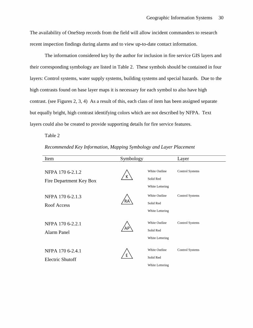
The information considered key by the author for inclusion in fire service GIS layers and
their corresponding symbology are listed in Table 2. These symbols should be contained in four
layers: Control systems, water supply systems, building systems and special hazards. Due to the
high contrasts found on base layer maps it is necessary for each symbol to also have high
contrast. (see Figures 2, 3, 4) As a result of this, each class of item has been assigned separate
but equally bright, high contrast identifying colors which are not described by NFPA. Text
layers could also be created to provide supporting details for fire service features.
Table 2
Recommended Key Information, Mapping Symbology and Layer Placement
Item Symbology Layer
NFPA 170 6-2.1.2
Fire Department Key Box
White Outline
Solid Red
White Lettering
Control Systems
NFPA 170 6-2.1.3
Roof Access
White Outline
Solid Red
White Lettering
Control Systems
NFPA 170 6-2.2.1
Alarm Panel
White Outline
Solid Red
White Lettering
Control Systems
NFPA 170 6-2.4.1
Electric Shutoff
White Outline
Solid Red
White Lettering
Control Systems

Geographic Information Systems 31
NFPA 170 6-2.4.3.1.1
Liquefied Petroleum Gas Shutoff
White Outline
Solid Red
White Lettering
Control Systems
NFPA 170 6-2.4.3.1.2
Natural Gas Shutoff
White Outline
Solid Red
White Lettering
Control Systems
NFPA 170 6-4.2
Sprinkler Riser Valve
White Outline
Solid Green
White Lettering
Water Supply Systems
NFPA 170 6-4.3
Sprinkler Zone Valve
White Outline
Solid Green
White Lettering
Water Supply Systems
NFPA 170 6-4.4
Hose Connection
White Outline
Solid Blue
White Lettering
Water Supply Systems
NFPA 170 6-4.8
Fire Hydrant
White Outline
Solid Blue
White Lettering
Water Supply Systems
NFPA 170 6-4.9
Fire Department Connection
White Outline
Solid Green
White Lettering
Water Supply Systems
NFPA 170 6-5.4
Fire Pump Room
Black Outline
Solid Yellow
Black Lettering
Building Systems
NFPA 170 6-5.7
Electrical Transformer Room
Black Outline
Solid Yellow
Black Lettering
Building Systems
DOT Placard
Flammable Gas Storage
White Outline
Solid Red
White Lettering
Special Hazards
DOT Placard
Flammable Liquid Storage
White Outline
Solid Red
White Lettering
Special Hazards

Geographic Information Systems 32
NFPA 704
Hazardous Materials Storage
Black Outline
Typical NFPA
Blue/Red/Yellow
Special Hazards
Special/Unique Hazards
Text to be determined by hazard
Black Outline
Solid Orange
Black Lettering
Special Hazards
There are a variety of other NFPA 170 symbols that could, and eventually should, be
inserted into fire service GIS layers as key information. The timing of these additional symbols
can be debated by the geospatial team with input from end users. Other possible symbols for
consideration but not included in NFPA 170 are shown in Figure 1.
A. B. C.
Figure 1. A: Basement below. B: Lightweight truss construction. C: Hyperlink to
detailed site plans.
These symbols, when combined with GIS base layers allow the fire officer to begin his size-up
while responding. The summary of key information and special hazards is demonstrated in
figures 2-6.

Geographic Information Systems 33
Figure 2. Wide angle view of GIS base map showing a target building, exposures, and
roadways. Fire service layers may be on, but viewing them requires zooming closer.
Figure 3. Close-up view of target building with control systems and water supply layers
toggled on.

Geographic Information Systems 34
Figure 4. Target building with orthoimagery and special hazards layers added. The need
for high contrast symbols is apparent.
Figure 5. GIS base map of residential neighborhood with special hazards and water
supply layers.

Geographic Information Systems 35
Figure 6. Overview of an Everett waterfront facility with special hazards layer and
hyperlink to detailed site plans.
The fire service is currently collecting a wide range of data during its daily work
activities. Unfortunately there is a disconnect between the collection and storage of that data and
the ability to utilize it for improved performance in the field. GIS software is the nexus for all
these pieces of information collected for different purposes by different members within an
organization. GIS allows for effective use of key information by displaying it in a graphical
format that is familiar to firefighters.
Full adoption of NFPA 1620 is a worthy goal for the Everett Fire Department, but would
take years to accomplish. GIS allows an intermediate step, which would give company officers
access to a summary of “key elements” (NFPA, 2010) while responding to alarms. This concept
is recommended by the NFPA as an essential part of a pre-incident planning program, and will
improve Everett’s firefighter safety and level of service to our community.

Geographic Information Systems 36
Reference List
Bloom, P. S. (1998). Administrative and Political Implications of GIS Implementation within the
Fire Service; A Case Study of Norfolk, VA. Unpublished master’s thesis, Virginia
Polytechnic Institute, Blacksburg, Virginia.
ESRI ArcGIS Resource Center (n.d.). Retrieved July 7, 2010, from
http://help.arcgis.com/en/arcgisdesktop/10.0/help/index.html
ESRI. (n.d.). GIS Explorer. [Computer Software]. Retrieved August 3, 2010, from
http://www.esri.com/software/arcgis/explorer/download.html
Gordon, M. (2010, March 6). Everett Fire Chief. (D. DeMarco, Interviewer)
Innes, J. E., & Simpson, D. M. (1993). Implementing GIS for Planning. Journal of the American
Planning Association , 59 (2), 230-234.
Linder, B. (2010, July 12). Everett GIS Technician. (D. DeMarco, Interviewer)
National Alliance for Public Safety GIS. (n.d.). A Quick Guide to Building a GIS for your Fire
Department. Retrieved May 6, 2010, from http://www.esri.com/library/
brochures/pdfs/gis-for-fire-department.pdf
National Alliance for Public Safety GIS. (2007). Successful Response Starts with a Map:
Improving Geospatial Support for Disaster Management. Washington, D.C.: National
Academies Press.
NFPA. (1998). Fire Prtection Handbook. Quincy, MA: National Fire Protection Association.
NFPA. (2009) NFPA 170: Standard on Fire Safety Symbols. 2009 Edition. National Fire
Protection Association. Quincy, MA: National Fire Protection Association.
NFPA. (2010). Firefigher Fatalities in the United States - 2009. Retrieved August 18, 2010,
from http://www.nfpa.org/assets/files/pdf/osfff.pdf
Geographic Information Systems 37
NFPA. (2010). NFPA 1620: Standard for Pre-Incident Planning. 2010 Edition. National Fire
Protection Association. Quincy, MA: National Fire Protection Association.
NIOSH. (2009). Death in the Line of Duty. Retrieved August 2, 2010, from
http://www.cdc.gov/niosh/fire/pdfs/face200718.pdf
Pictometry International. (2010). About Us. Retrieved May 10, 2010, from
http://www.pictometry.com/about_us/overview.shtml
Price, M. (2010, Summer). Is Data Driving Your Fire Engine. ArcUser, 34-39.
Price, M. (2009, Fall). It's All About Streets. ArcUser , 47-49.
Robinson, R. (2010, July 28). Everett Fire Marshal. (D. DeMarco, Interviewer)
St. John, M. (2007). Map Quest. Fire Chief, Retrieved March 3, 2010, from
http://firechief.com/technology/computers-software/firefighting_map_quest/
Theodore, J. (2009). Central Nervous System. Fire Chief, Retrieved March 3, 2010, from
http://firechief.com/technology/computers-software/gis-coordinate-multiagency-
response-200905/index1.html
USFA. (1995). Technical Report Series. Retrieved June 10, 2010, from
http://www.usfa.dhs.gov/downloads/pdf/publications/tr-077.pdf
USFA. (2003). Geographic Information Systems Tutorial. [Computer Software]. Emmitsburg,
MD: United States Fire Administration.
USFA. (2007). The National Fire Incident Reporting System. Retreived June 1, 2010 from
http://www.usfa.dhs.gov/fireservice/nfirs/
USFA. (2010). Fiscal Year 2009 Report to Congress. Retrieved April 22, 2010 from
http://www.usfa.dhs.gov/downloads/pdf/annual_reports/fy09_usfa_annual_report.pdf

Geographic Information Systems 38
Walker, M. (2009). Systematic Size-up Reports for Structure Fires. Fire Engineering. Retrieved
July 16, 2010, from http://www.fireengineering.com/index/articles/display.articles.
fireengineering.firefighting.structural.2009.9.systematic-size-up-reports-for-structure-
fires.html
Wollenweber, B. (2010, June 16). New World Systems GIS Specialist. (D. DeMarco,
Interviewer)

Geographic Information Systems 39
Appendix A
NFPA 1620 Data, its EFD Collected Status, its Storage Location and Availability
Standard Requirement Collected Location Availability5.2.1 Building Area No5.2.1 Building Age No5.2.1 Building Height Partial OneStep In Station5.2.2.1 Construction Type Yes OneStep In Station5.2.2.2 Wall construction and insulation details No5.2.2.3 Roof construction details Yes OneStep In Station5.2.2.4 Floor construction details No5.2.2.5 Other pertinent construction details No5.2.2.6 Data regarding all structural access features No5.2.2.7 Description of areas of potential fire spread No5.2.2.8 Data regarding atriums No5.2.2.9 Structural integrity of walls, roofs, and floors No5.2.2.10 Site storage arrangements No5.2.2.11 Fire command center location and fire rating of
surrounding fire walls.Partial Site Plans On Alarms
5.3.1 Emergency contact information Yes OneStep In Station5.3.2 Utility systems data No5.3.2.1 Transformers with combustible liquids identified No5.3.2.2 Electric utility rooms located Yes Site Plans On Alarms5.3.2.3 Emergency power capability recorded No5.3.2.4 Manual activation method for emergency power
describedNo
5.3.2.5 Domestic water shutoff identified No5.3.2.6 Location of compressed and liquified gases No5.3.2.7 Steam lines and boiler location and shutoff No5.3.2.8.1 Systems with mutliple fuels supplies identified No5.3.2.8.2 All gas shutoffs located Partial Site Plans On Alarms5.3.2.8.3 Location , size and shutoff for all LP tanks Partial Site Plans On Alarms5.3.2.8.4 Location of all fuel pumps, tanks, and shutoffs No5.3.3.2 Note presence of fire/smoke resist elevator
lobbiesNo
5.4.1 Access points for responding personnel Partial Site Plans On Alarms5.4.2. Obstacles to access Partial Site Plans On Alarms5.5 Internal and external security features No5.6 Fences and other barriers Partial Site Plans On Alarms5.7 Secutiry animals No5.8.1 Security systems recorded No5.8.2 Contact information for security system No5.9.1 Exposures identified No5.10.1 Site communications equipment identified No
Geographic Information Systems 40
Appendix A Cont’d
Standard Requirement Collected Location Availability5.10.2 Fire communications equipment impacted No6.2.1.1 Life-safety strategies for evacuation or defend in
place identifiedNo
6.2.1.2 Hours of operation No6.2.1.2 Occupant Load No6.2.1.2 Assistance for the disabled No6.2.1.2 Strategies for protection of occupants other than
evacuationNo
6.2.2 All means of egress Partial Site Plan On Alarms6.3.1 Facility emergency action plan details No6.3.2 Facility emergency response capability No6.3.3 Special operations, processes, or hazards No7.2 Firefighting water supply identified Yes Site Plan On Alarms7.2.1 Required fire flow predetermined No7.2.2.1 Available water supply included No7.2.2.2 Available water vs. fire flow required determined
and addressedNo
7.2.3 Public v. private water supplies identified No7.2.4 Static water supplies identified No7.2.5.1 Fixed tank systems identified and labeled No7.3.1 Sprinkler systems locations, valves, areas served
identifiedPartial Site Plan On Alarms
7.3.2 Standpipe systems locations, valves, areas served identified
Partial Site Plan On Alarms
7.3.3 Fire pumps located and system identified No7.3.4 FDC location and areas supplied identified Partial Site Plan On Alarms7.4 Non-water systems described and identified Partial Site Plan On Alarms7.5 Fire alarm systems, panels, annuciators described Partial Site Plan On Alarms
7.6 Portable fire extiguishers located No7.7.1 Smoke control systems identified No7.7.2 Smoke and heat vents identified No8.1 Any special hazards identified Partial Site Plan,
NEMSIS, NFIRS
Partial
8.2 Transient conditions at discretion of AHJ No8.3 Maximum inventory of hazmats included No8.4.1 Large scale gatherings identified No8.4.2.1 Use or storage of explosives identified No8.4.2.1.1 Presense, volume, location and class of explosives
identifiedNo

Geographic Information Systems 41
Appendix A Cont’d
Standard Requirement Collected Location Availability8.4.2.1.2 Other common materials that may explode
identifiedNo
8.4.2.1.3 Isolation and evacuation distances for explosives predetermined
No
8.4.2.2 Features for storage and containment of flammable liquids identified
No
8.4.2.3.1 Toxic or biologic agents located and identified No8.4.2.3.2 Downrange effect of toxics or biologic agents
predeterminedNo
8.4.2.4.1 Radioactive materials type and location No8.4.2.4.2 Isolation and evacuation distances for radioactives
predeterminedNo
8.4.3 Special hazardous atmospheres identified No
Geographic Information Systems 42
Appendix B
NFPA 1620: Pre-Incident Planning Recommended Practices vs. Everett Fire Department Site-Plan Practices
Standard Requirement EFD Practice4.1.5 NIMS Compliants IMS System in Use? Yes4.1.8 PIPs Begun during building design phase? No4.1.9 PIPs Evaluate Life Safety Hazard No4.1.9 PIPS Evaluate Structure Size Partial4.1.9 PIPs Evaluate Operations Complexity No4.1.9 PIPs Evaluate Economic Impact No4.1.9 PIPs Evaluate Location and Seasonal Change No4.1.9 PIPs Evaluate Presence of Hazardous Materials No4.1.9 PIPs Evaulate Susceptibility to natural disaster No4.3.1.3 PIPs Data evaulated for criticality No4.5 Standardized PIP Document? Yes4.6 NFPA 170 Symbols in use? Partial4.7 PIPs Distributed to essential users? Yes4.8 PIPs used for training in unique circumstances? No4.9 PIPs available to IC during incidents? Yes4.10.1 PIPs evaluated for accuracy post-incident? No4.10.2 PIPs revised as needed? No9.1 Summary of key PIP information available while
respondingPartial
9.2 Critical PIP information available at time of dispatch Partial9.3.1 Initial response units described No9.3.3 Summary of initial actions based on life safety, scene
stabilization and incident mitigationNo
9.3.4 IMS plan in place Yes10.1.1 Periodic testing of PIP and review of accuracy No10.2.1 Updates to PIP periodically No

Geographic Information Systems 43
Appendix C
GIS Layers Owned by the City of Everett and their Usefulness during Emergency Response
Existing GIS Layer Useful During Responses
Water Meters YesWater Services YesWater Hydrants YesWater System Valves YesWater Control Valves YesWater Manholes YesWater Network Structures YesWater FittingsWater Cathodic ProtectionWater Mains YesWater CasingWater Structures YesWater EasementsSewer Service YesSewer System Valves YesSewer Manholes YesSewer FittingsSewer network Structures YesSewer Mains YesSewer CasingSewer Cathodic ProtectionSewer EasementStorm Drainage Service YesStorm Drainage FittingsStrom Drainage Manholes YesStorm Drainage Catch Basins YesStorm Drainage Equipment YesStorm Drainage Mains YesNatural Drainage YesDrainage CasingsDetention Facilities YesDrainage EasmentsStreet SignsResidential Parking ZonesPreliminary Buildings

Geographic Information Systems 44
Appendix C Cont’d
Existing GIS Layer Useful During Responses
Preliminary DevelopmentsBuildings YesBuilding Details Text YesQuarter SectionsTreesLandscapingTrails YesPolesContour YesStreet Centerline YesBridges YesStreets and Paved Alleys YesDikes YesCity PropertyCity Limits YesHydrography YesParcelsLots YesRowUtility EasementsCadastral EasmentShort PlatSubdivisionsUrban Growth AreaCentral Business DistrictNeighborhood BoundariesAnnexationsZoningLanduseZipcodesIndexPictometry Imagery Yes2009 Aerial Imagery Yes2007 Aerial Imagery2003 Aerial Imagery