using ecological site descriptions to manage sagebrush
TRANSCRIPT

Photo by A. Wilson, Oregon Fish and Wildlife web site
Using Ecological Site Descriptions to Manage Sagebrush EcosystemsHistory, Overview and Applications of ESDs for Management
Fee Busby, Department of Wildland Resources,
College of Natural Resources, Utah State University, Logan, UT


An ecological site is an area of land with specific physical characteristics that differs from other kinds of land in its ability to produce a distinctive kind and amount of vegetation and to respond to management.
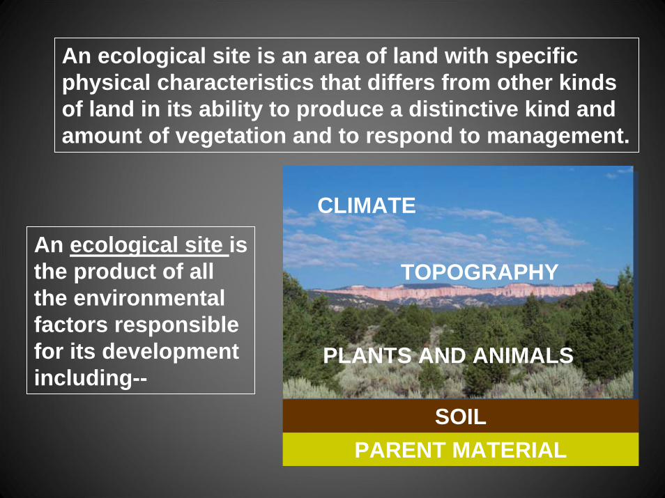
An ecological site is an area of land with specific physical characteristics that differs from other kinds of land in its ability to produce a distinctive kind and amount of vegetation and to respond to management.
An ecological site is the product of all the environmental factors responsible for its development including--
SOILPARENT MATERIAL
CLIMATE
TOPOGRAPHY
PLANTS AND ANIMALS
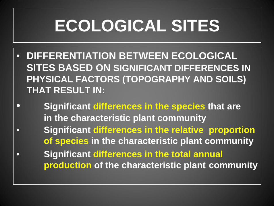
ECOLOGICAL SITES• DIFFERENTIATION BETWEEN ECOLOGICAL
SITES BASED ON SIGNIFICANT DIFFERENCES IN PHYSICAL FACTORS (TOPOGRAPHY AND SOILS) THAT RESULT IN:
• Significant differences in the species that arein the characteristic plant community
• Significant differences in the relative proportion of species in the characteristic plant community
• Significant differences in the total annual production of the characteristic plant community
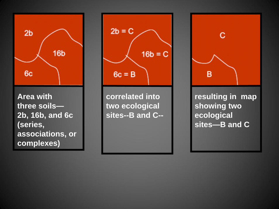
Area withthree soils—2b, 16b, and 6c(series, associations, or complexes)
correlated into two ecological sites--B and C--
resulting in map showing two ecological sites—B and C
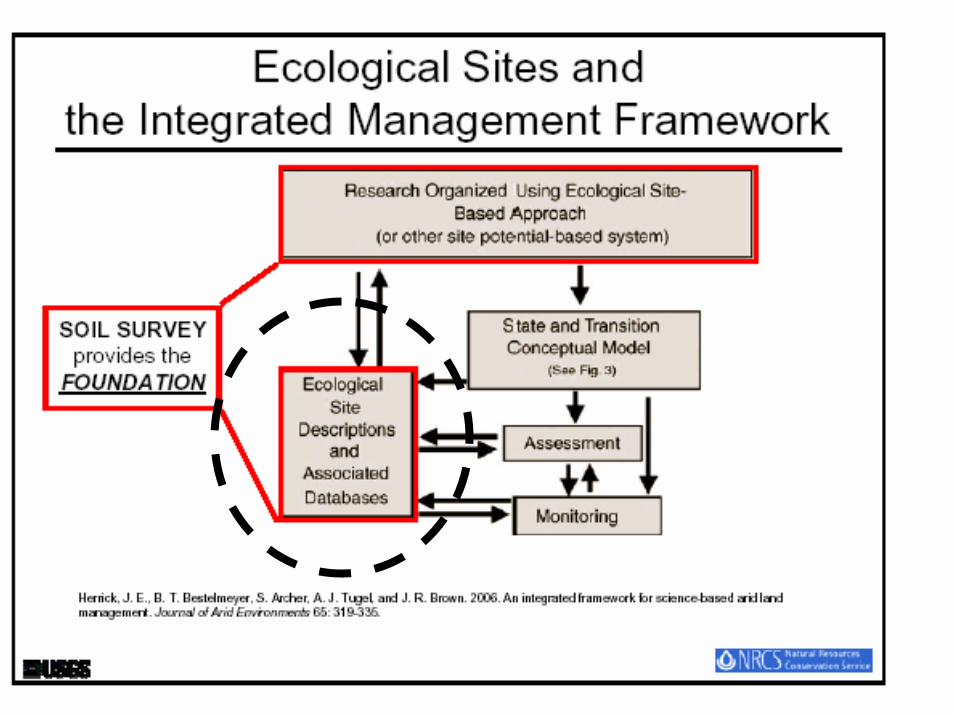
ECOLOGICAL SITES
• Ecological site classification represents our best approximation of how the landscape works as we understand it at this moment in time. Ecological site classification will always be our current approximation as to how the world is organized.

ECOLOGICAL SITES
• The land classification represented by ecological sites represents a “file” where we can record information we have about the site. Accumulation of information over time will make our next approximation of how the word is organized even better.
ECOLOGICAL SITES
• As the ecological site classification represents our current best knowledge of how the world is organized, and is the collection of what we currently know about the site, the site description is an excellent place for a resource conservationist to learn about the lands in his or her work location.
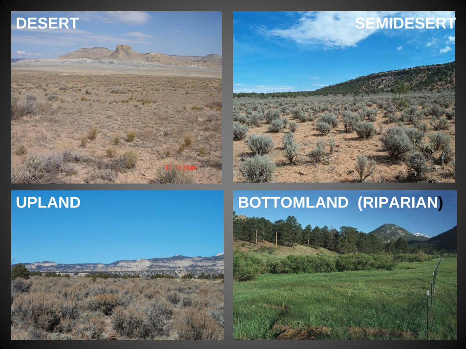
DESERT SEMIDESERT
UPLAND BOTTOMLAND (RIPARIAN)
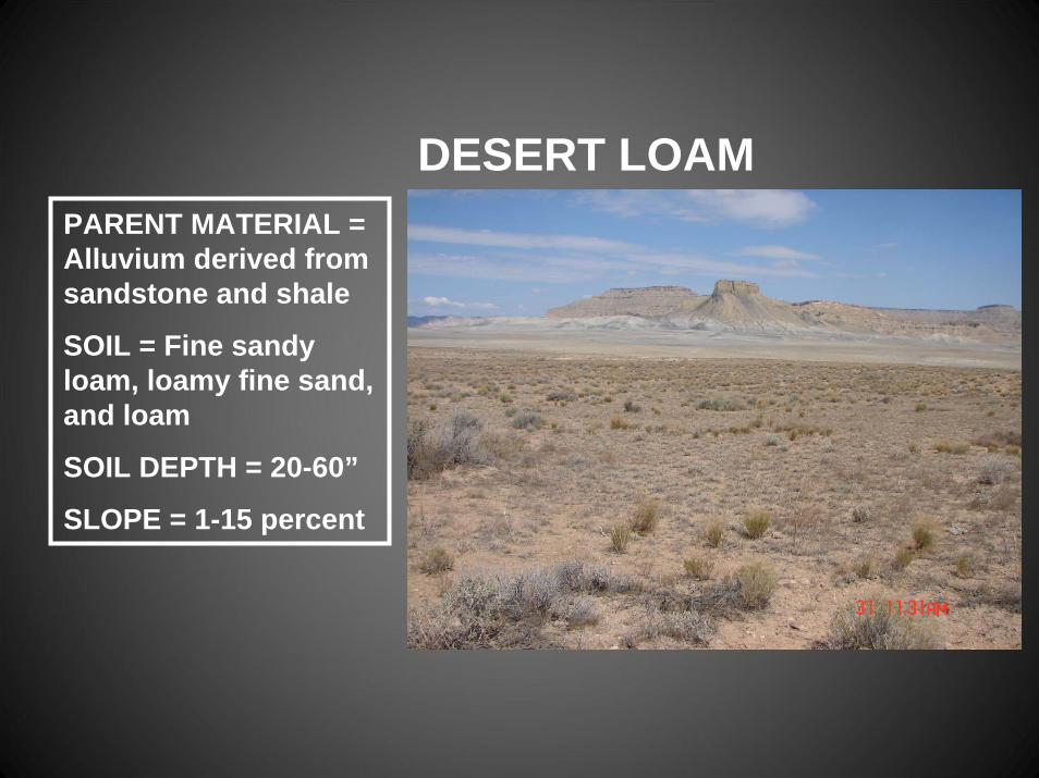
DESERT LOAMPARENT MATERIAL = Alluvium derived from sandstone and shale
SOIL = Fine sandy loam, loamy fine sand, and loam
SOIL DEPTH = 20-60”
SLOPE = 1-15 percent
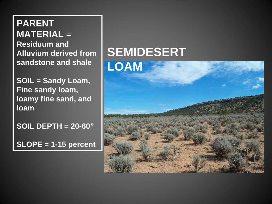
SEMIDESERT LOAM
PARENT MATERIAL = Residuum and Alluvium derived from sandstone and shale
SOIL = Sandy Loam, Fine sandy loam, loamy fine sand, and loam
SOIL DEPTH = 20-60”
SLOPE = 1-15 percent

UPLAND LOAM
PARENT MATERIAL = Residuum and Alluvium derived from sandstone
SOIL = Sandy Loam, Fine sandy loam, loamy fine sand, and loam
SOIL DEPTH = 20-60”
SLOPE = 1-15 percent
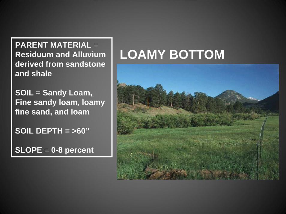
LOAMY BOTTOMPARENT MATERIAL = Residuum and Alluvium derived from sandstone and shale
SOIL = Sandy Loam, Fine sandy loam, loamy fine sand, and loam
SOIL DEPTH = >60”
SLOPE = 0-8 percent
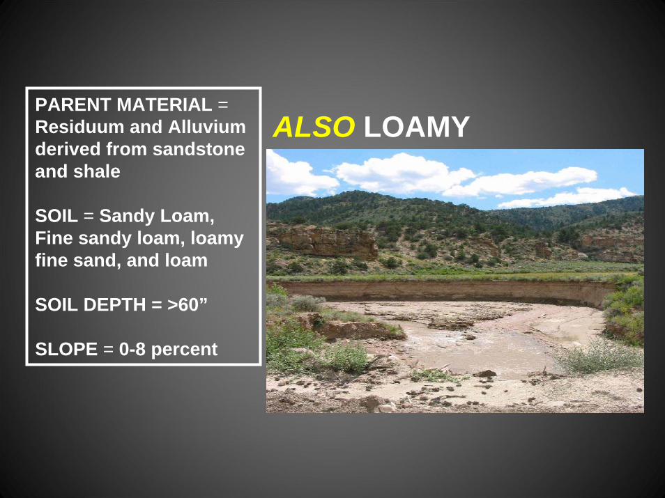
ALSO LOAMY BOTTOM
PARENT MATERIAL = Residuum and Alluvium derived from sandstone and shale
SOIL = Sandy Loam, Fine sandy loam, loamy fine sand, and loam
SOIL DEPTH = >60”
SLOPE = 0-8 percent
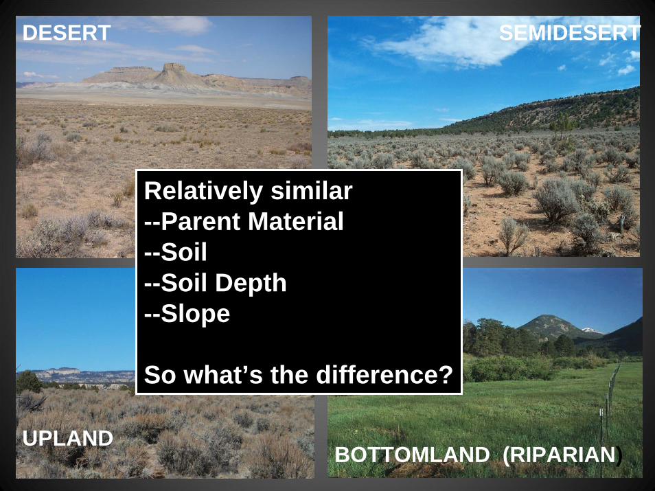
DESERT SEMIDESERT
UPLANDBOTTOMLAND (RIPARIAN)
Relatively similar--Parent Material--Soil--Soil Depth--Slope
So what’s the difference?
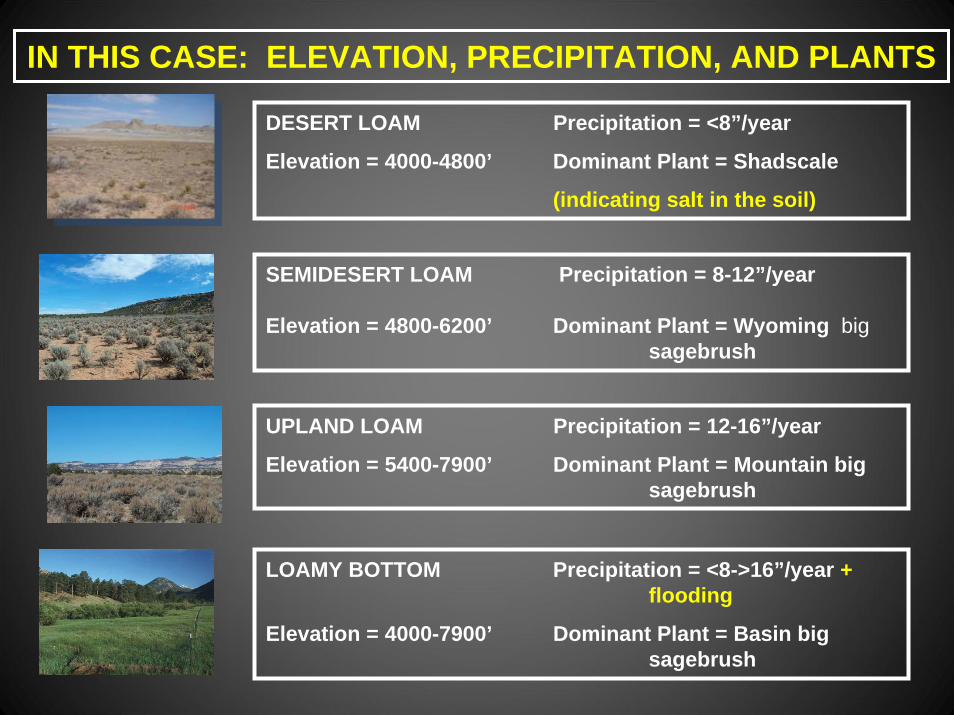
IN THIS CASE: ELEVATION, PRECIPITATION, AND PLANTS
DESERT LOAM Precipitation = <8”/year
Elevation = 4000-4800’ Dominant Plant = Shadscale
(indicating salt in the soil)
SEMIDESERT LOAM Precipitation = 8-12”/year
Elevation = 4800-6200’ Dominant Plant = Wyoming bigsagebrush
UPLAND LOAM Precipitation = 12-16”/year
Elevation = 5400-7900’ Dominant Plant = Mountain big sagebrush
LOAMY BOTTOM Precipitation = <8->16”/year + flooding
Elevation = 4000-7900’ Dominant Plant = Basin big sagebrush
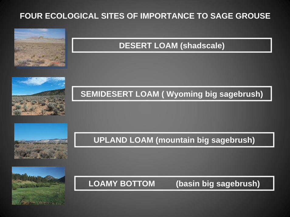
FOUR ECOLOGICAL SITES OF IMPORTANCE TO SAGE GROUSE
DESERT LOAM (shadscale)
SEMIDESERT LOAM ( Wyoming big sagebrush)
UPLAND LOAM (mountain big sagebrush)
LOAMY BOTTOM (basin big sagebrush)
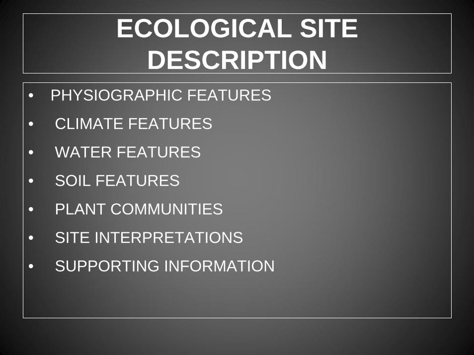
ECOLOGICAL SITE DESCRIPTION
• PHYSIOGRAPHIC FEATURES
• CLIMATE FEATURES
• WATER FEATURES
• SOIL FEATURES
• PLANT COMMUNITIES
• SITE INTERPRETATIONS
• SUPPORTING INFORMATION

ECOLOGICAL SITE DESCRIPTION
PLANT COMMUNITY INFORMATION• ECOLOGICAL DYNAMICS OF SITE• STATE AND TRANSITION DIAGRAM• PLANT COMMUNITIES
• COMMUNITY NARRATIVE• ANNUAL PRODUCTION• SPECIES COMPOSITION• GROWTH CURVES• COVER AND STRUCTURE• PHOTOS
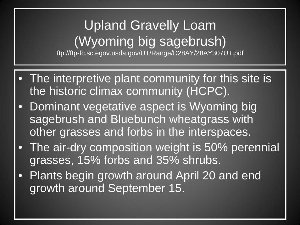
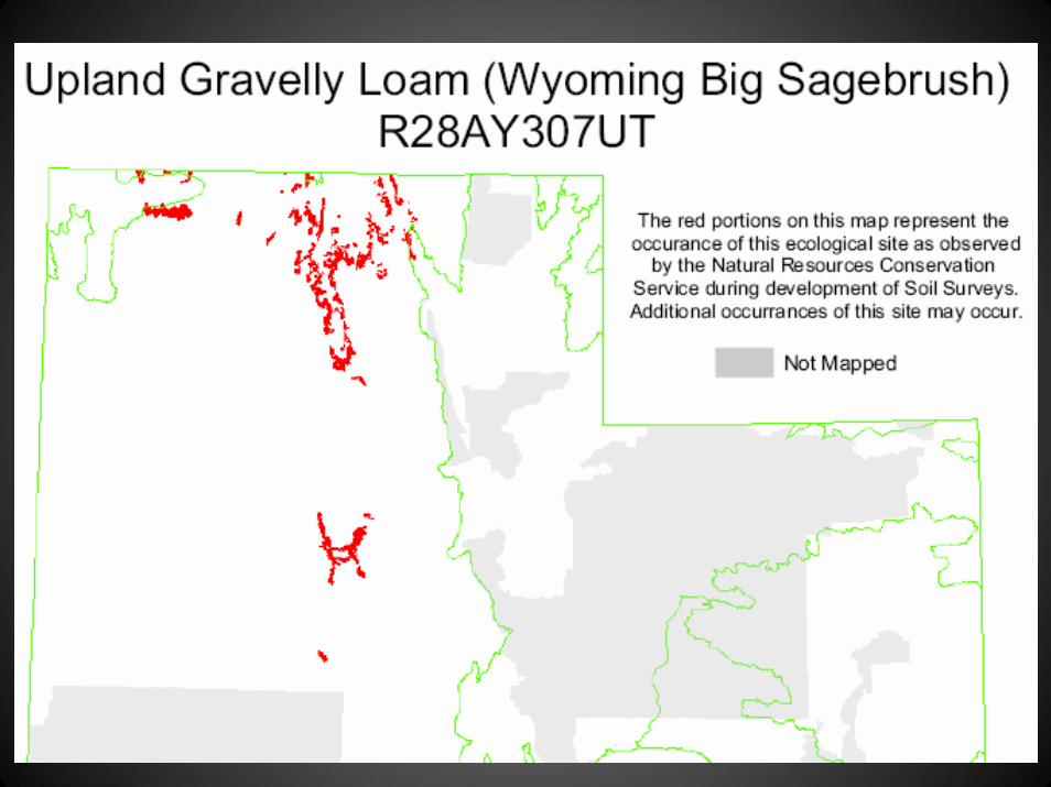
Upland Gravelly Loam (Wyoming big sagebrush)
ftp://ftp-fc.sc.egov.usda.gov/UT/Range/D28AY/28AY307UT.pdf
• The interpretive plant community for this site is the historic climax community (HCPC).
• Dominant vegetative aspect is Wyoming big sagebrush and Bluebunch wheatgrass with other grasses and forbs in the interspaces.
• The air-dry composition weight is 50% perennial grasses, 15% forbs and 35% shrubs.
• Plants begin growth around April 20 and end growth around September 15.
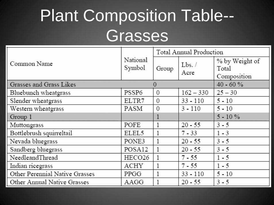
Plant Composition Table--Grasses

Plant Composition Table--Forbs

Plant Production and Composition Tables
“LOW” = UNFAVORABLE AND “HIGH” = FAVORABLE GROWING CONDITIONSF
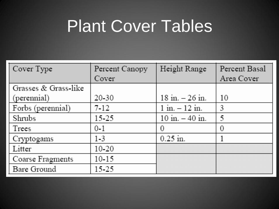
Plant Cover Tables

STATE AND TRANSITION MODELHistoric Climax Plant Community State
Perennial Grasses Wyoming Big Sagebrush
Perennial GrassesWyoming Big Sagebrush
co-dominant with Perennial Grasses
Wyoming Big Sagebrushco-dominant with
Perennial Grasses ;Few Utah Juniper
Upland Gravelly Loam (Wyoming big sagebrush)
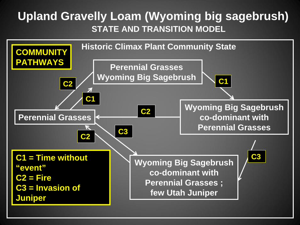
STATE AND TRANSITION MODEL
Historic Climax Plant Community State
Perennial Grasses Wyoming Big Sagebrush
Perennial GrassesWyoming Big Sagebrush
co-dominant with Perennial Grasses
Wyoming Big Sagebrushco-dominant with
Perennial Grasses ;few Utah Juniper
C1 = Time without“event”C2 = FireC3 = Invasion ofJuniper
C2 C1
C2
C3
C3
C2
C1
Upland Gravelly Loam (Wyoming big sagebrush)
COMMUNITYPATHWAYS

STATE AND TRANSITION MODEL
Historic Climax Plant Community State
Perennial Grasses Wyoming Big Sagebrush
Perennial GrassesWyoming Big Sagebrush
co-dominant with Perennial Grasses
Wyoming Big Sagebrushco-dominant with
Perennial Grasses ;few Utah Juniper
C2 C1
C2
C3
C3
C2
C1
Upland Gravelly Loam (Wyoming big sagebrush)
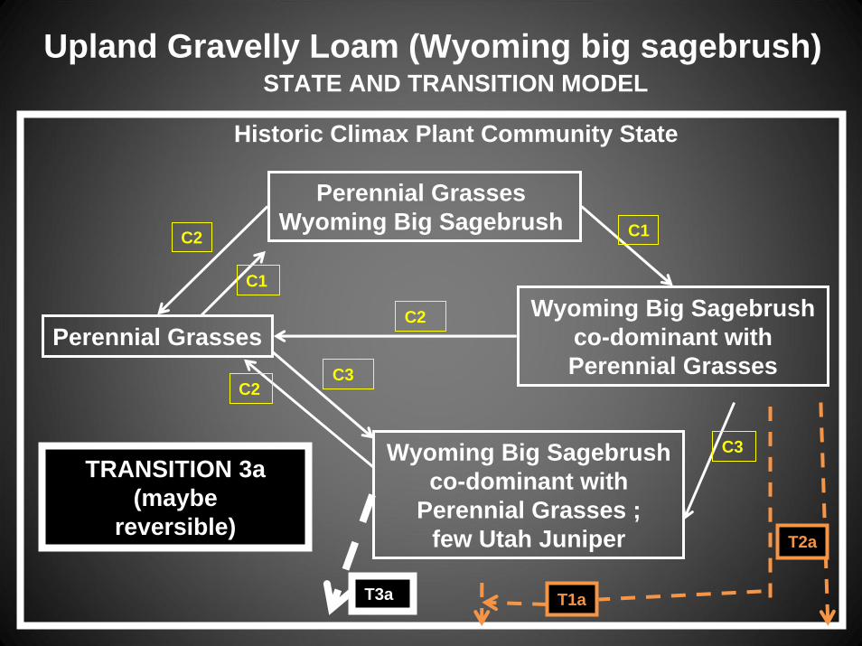
TRANSITIONS(maybe reversible)
T3a T1a
T2a

STATE AND TRANSITION MODEL
Historic Climax Plant Community State
Perennial Grasses Wyoming Big Sagebrush
Perennial GrassesWyoming Big Sagebrush
co-dominant with Perennial Grasses
Wyoming Big Sagebrushco-dominant with
Perennial Grasses ;few Utah Juniper
C2 C1
C2
C3
C3
C2
C1
Upland Gravelly Loam (Wyoming big sagebrush)
TRANSITION 1a (maybe reversible)
T3a T1a
T2a

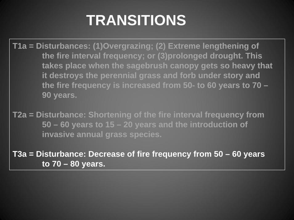
T1a = Disturbances: (1)Overgrazing; (2) Extreme lengthening of the fire interval frequency; or (3)prolonged drought. This takes place when the sagebrush canopy gets so heavy that it destroys the perennial grass and forb under story and the fire frequency is increased from 50- to 60 years to 70 –90 years.
TRANSITIONS

STATE AND TRANSITION MODEL
Historic Climax Plant Community State
Perennial Grasses Wyoming Big Sagebrush
Perennial GrassesWyoming Big Sagebrush
co-dominant with Perennial Grasses
Wyoming Big Sagebrushco-dominant with
Perennial Grasses ;few Utah Juniper
C2 C1
C2
C3
C3
C2
C1
Upland Gravelly Loam (Wyoming big sagebrush)
TRANSITION 2a(maybe
reversible)
T3a T1a
T2a

T1a = Disturbances: (1)Overgrazing; (2) Extreme lengthening of the fire interval frequency; or (3)prolonged drought. This takes place when the sagebrush canopy gets so heavy that it destroys the perennial grass and forb under story and the fire frequency is increased from 50- to 60 years to 70 –90 years.
T2a = Disturbances: (1) Shortening of the fire interval frequency from 50 – 60 years to 15 – 20 years and (2) the introduction of invasive annual grass species.
TRANSITIONS
STATE AND TRANSITION MODEL
Historic Climax Plant Community State
Perennial Grasses Wyoming Big Sagebrush
Perennial GrassesWyoming Big Sagebrush
co-dominant with Perennial Grasses
Wyoming Big Sagebrushco-dominant with
Perennial Grasses ;few Utah Juniper
C2 C1
C2
C3
C3
C2
C1
Upland Gravelly Loam (Wyoming big sagebrush)
TRANSITION 3a(maybe
reversible)
T3a T1a
T2a
T1a = Disturbances: (1)Overgrazing; (2) Extreme lengthening of the fire interval frequency; or (3)prolonged drought. This takes place when the sagebrush canopy gets so heavy that it destroys the perennial grass and forb under story and the fire frequency is increased from 50- to 60 years to 70 –90 years.
T2a = Disturbance: Shortening of the fire interval frequency from 50 – 60 years to 15 – 20 years and the introduction of invasive annual grass species.
T3a = Disturbance: Decrease of fire frequency from 50 – 60 years to 70 – 80 years.
TRANSITIONS
STATE AND TRANSITION MODEL
Historic Climax Plant Community State
HSPC StateWith
Invasive Annuals
Perennial Grasses co-dominant withInvasive Annuals;
Fire Tolerant Shrubs
Wyoming Big Sagebrush and
Perennial Grasses ;co-dominant with
invasive annuals and few Utah Junipers
C7
C6 C6
C4
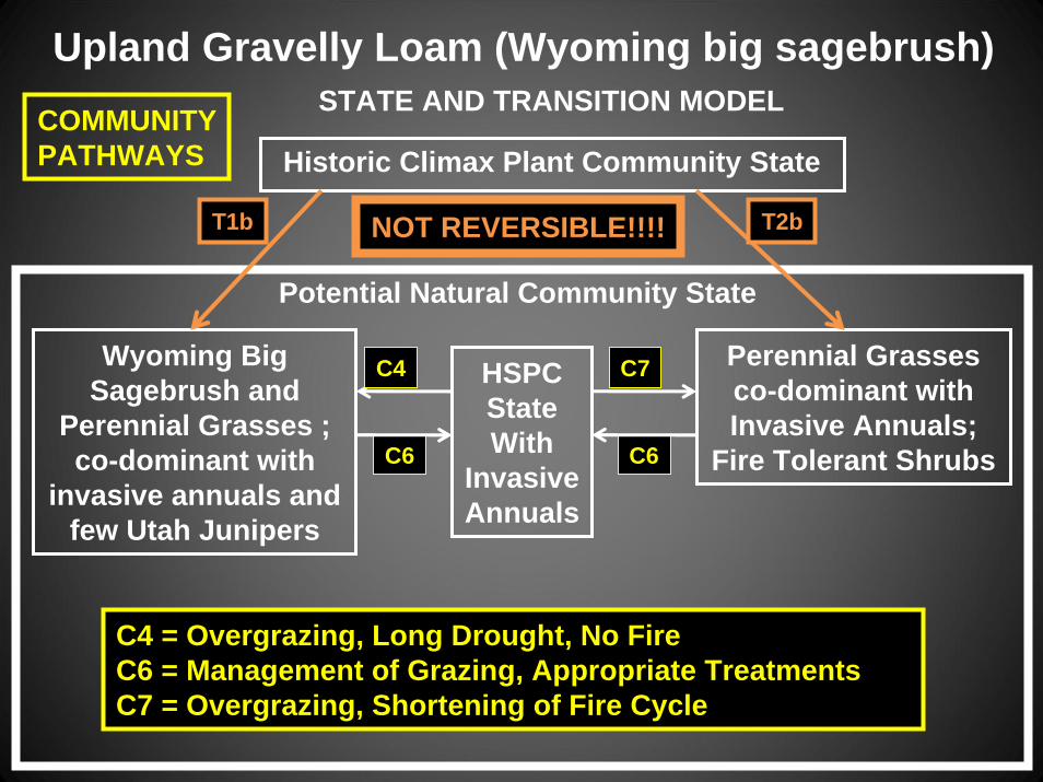
Upland Gravelly Loam (Wyoming big sagebrush)
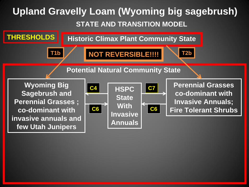
T1b T2b
THRESHOLDS
NOT REVERSIBLE!!!!
Potential Natural Community State
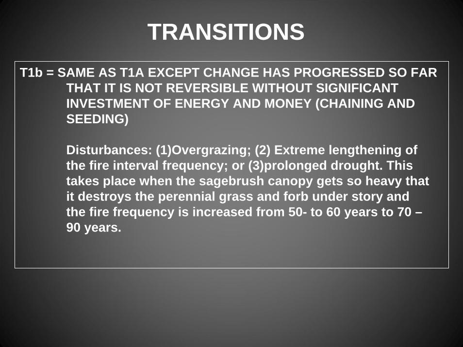
T1b = SAME AS T1A EXCEPT CHANGE HAS PROGRESSED SO FAR THAT IT IS NOT REVERSIBLE WITHOUT SIGNIFICANT INVESTMENT OF ENERGY AND MONEY (CHAINING AND SEEDING)
Disturbances: (1)Overgrazing; (2) Extreme lengthening of the fire interval frequency; or (3)prolonged drought. This takes place when the sagebrush canopy gets so heavy that it destroys the perennial grass and forb under story and the fire frequency is increased from 50- to 60 years to 70 –90 years.
TRANSITIONS
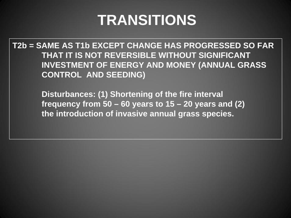
T2b = SAME AS T1b EXCEPT CHANGE HAS PROGRESSED SO FAR THAT IT IS NOT REVERSIBLE WITHOUT SIGNIFICANT INVESTMENT OF ENERGY AND MONEY (ANNUAL GRASS CONTROL AND SEEDING)
Disturbances: (1) Shortening of the fire interval frequency from 50 – 60 years to 15 – 20 years and (2) the introduction of invasive annual grass species.
TRANSITIONS
STATE AND TRANSITION MODEL
Historic Climax Plant Community State
HSPC StateWith
Invasive Annuals
Perennial Grasses co-dominant withInvasive Annuals;
Fire Tolerant Shrubs
Wyoming Big Sagebrush and
Perennial Grasses ;co-dominant with
invasive annuals and few Utah Junipers
C7
C6 C6
C4
Upland Gravelly Loam (Wyoming big sagebrush)
T1b T2b
C4 = Overgrazing, Long Drought, No FireC6 = Management of Grazing, Appropriate TreatmentsC7 = Overgrazing, Shortening of Fire Cycle
COMMUNITYPATHWAYS
NOT REVERSIBLE!!!!
Potential Natural Community State
STATE AND TRANSITION MODEL
Historic Climax Plant Community State
HSPC StateWith
Invasive Annuals
Perennial Grasses co-dominant withInvasive Annuals;
Fire Tolerant Shrubs
Wyoming Big Sagebrush and
Perennial Grasses ;co-dominant with
invasive annuals and few Utah Junipers
C7
C6 C6
C4
Upland Gravelly Loam (Wyoming big sagebrush)
T1b T2bNOT REVERSIBLE!!!!
Potential Natural Community State
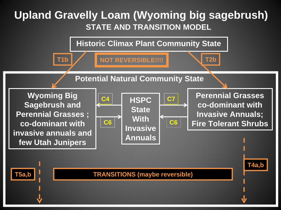
TRANSITIONS (maybe reversible)T5a,bT4a,b

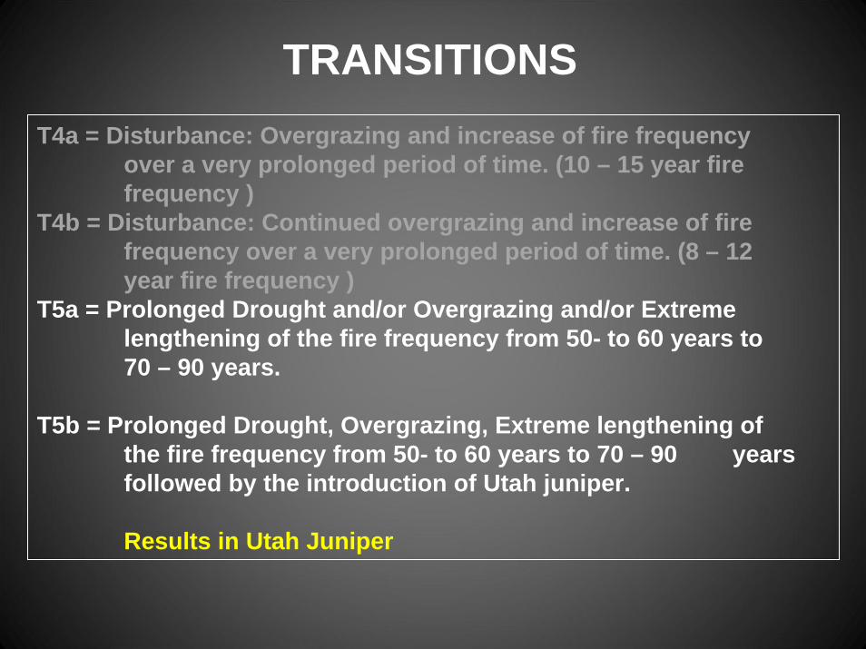
T4a = Disturbance: Overgrazing and increase of fire frequency over a very prolonged period of time. (10 – 15 year fire frequency )
T4b = Disturbance: Continued overgrazing and increase of fire frequency over a very prolonged period of time. (8 – 12 year fire frequency )
Results in annual grasses and fire tolerant shrubs
TRANSITIONS
T4a = Disturbance: Overgrazing and increase of fire frequency over a very prolonged period of time. (10 – 15 year fire frequency )
T4b = Disturbance: Continued overgrazing and increase of fire frequency over a very prolonged period of time. (8 – 12 year fire frequency )
T5a = Prolonged Drought and/or Overgrazing and/or Extreme lengthening of the fire frequency from 50- to 60 years to 70 – 90 years.
T5b = Prolonged Drought, Overgrazing, Extreme lengthening of the fire frequency from 50- to 60 years to 70 – 90 years followed by the introduction of Utah juniper.
Results in Utah Juniper
TRANSITIONS

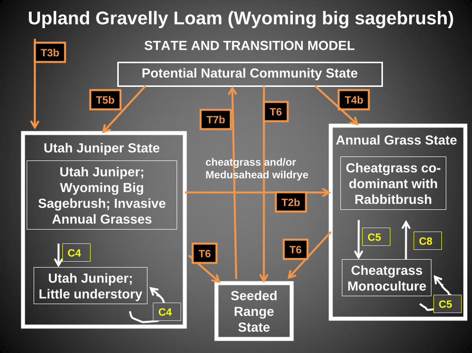
Seeded Range State
STATE AND TRANSITION MODEL
Potential Natural Community State
Upland Gravelly Loam (Wyoming big sagebrush)
T5b T4b
Utah Juniper;Wyoming Big
Sagebrush; Invasive Annual Grasses
Utah Juniper State
Utah Juniper;Little understory
Annual Grass State
Cheatgrass co-dominant withRabbitbrush
CheatgrassMonoculture
T3b
C4
C4
C5
C5
C8
NOT REVERSIBLE!!!!

C4 = Overgrazing, prolonged drought, no fire
Results in Utah Juniper with little or no understory
C5 = Increased fire frequency (10 – 15 years to 3 – 5 years) and intensity without follow up management (seeding)
Results in cheatgrass and/or Medusahead wildrye
C8 = Lengthening of fire interval (3 – 5 years to 10 – 15 years)
Results in cheatgrass and/or Medusahead wildrye and fire tolerant shrubs such as rabbitbrush
TRANSITIONS
Seeded Range State
STATE AND TRANSITION MODEL
Potential Natural Community State
Upland Gravelly Loam (Wyoming big sagebrush)
T5b T4b
Utah Juniper;Wyoming Big
Sagebrush; Invasive Annual Grasses
Utah Juniper State
Utah Juniper;Little understory
Annual Grass State
Cheatgrass co-dominant withRabbitbrush
CheatgrassMonoculture
T3b
T2b
T6
T6T7b
T6C4
C4
C5 C8
C5
cheatgrass and/or Medusahead wildrye

T2b = Shortening of fire interval, introduction of invasive annual grasses, increase in fire tolerant shrubs
T6 = Weed and brush management, rangeland seeding
T7a and b= Proper management and long term succession
TRANSITIONS
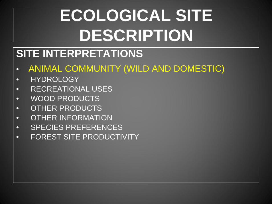
ECOLOGICAL SITE DESCRIPTION
SITE INTERPRETATIONS• ANIMAL COMMUNITY (WILD AND DOMESTIC)• HYDROLOGY• RECREATIONAL USES• WOOD PRODUCTS• OTHER PRODUCTS• OTHER INFORMATION• SPECIES PREFERENCES• FOREST SITE PRODUCTIVITY
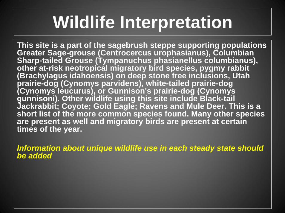
Wildlife InterpretationThis site is a part of the sagebrush steppe supporting populations Greater Sage-grouse (Centrocercus urophasianus), Columbian Sharp-tailed Grouse (Tympanuchus phasianellus columbianus), other at-risk neotropical migratory bird species, pygmy rabbit (Brachylagus idahoensis) on deep stone free inclusions, Utah prairie-dog (Cynomys parvidens), white-tailed prairie-dog (Cynomys leucurus), or Gunnison's prairie-dog (Cynomysgunnisoni). Other wildlife using this site include Black-tail Jackrabbit; Coyote; Gold Eagle; Ravens and Mule Deer. This is a short list of the more common species found. Many other species are present as well and migratory birds are present at certain times of the year.
Information about unique wildlife use in each steady state should be added