user’s manual for the national water information system of ... · user’s manual for the...
TRANSCRIPT

USER’S MANUAL FOR THE NATIONAL WATER INFORMATION SYSTEM OF THE U.S. GEOLOGICAL SURVEY WATER-QUALITY SYSTEM U.S. GEOLOGICAL SURVEY Open-File Report Version 4.4
Reston, Virginia 2006

U.S. DEPARTMENT OF THE INTERIOR U.S. GEOLOGICAL SURVEY Dr. P. Patrick Leahy, Acting Director The use of trade, product, or firm names in this report is for descriptive purposes only and does not imply endorsement by the U.S. Government. ________________________________________________________________________ For additional information write to: Copies of this report can be obtained from: U.S. Geological Survey U.S. Geological Survey Water Resources Division Water Resources Division NWIS Testing, Data Transfer, Support NWIS Testing, Data Transfer, Support and Maintenance Unit, Mail Stop 437 and Maintenance Unit, Mail Stop 437 12201 Sunrise Valley Drive 12201 Sunrise Valley Drive Reston, VA 20192 Reston, VA 20192 This report is accessible online at: http://wwwnwis.er.usgs.gov/nwisdocs4_4/qw/OpenFileDocs/QW.user.book.html

QWDATA: Table of Contents
Water Quality NWIS User i
Table of Contents 1. Introduction………………………………………………. 1
1.1. Description of NWIS……………………………………………………….. 1 1.2. QWDATA System Description……………………………………………. 2 1.3. User Access and Setup…………………………………………………….. 3 1.4. Acknowledgements………………………………………………………… 3
2. Getting Started……………………………….…………… 4 2.1. Terminology………………………………………………………………… 4
2.1.1. Sample……………………………………………….……………… .. 4 2.1.2. Result…………………………………………………………….…... 4 2.1.3. Parameter Code……………………….……………………………… .. 4 2.1.4. Record……………………………………………………………….. 4 2.1.5. Record Number………………………………………………………. 4 2.1.6. Site……………………………………………………………………. 5 2.1.7. Station Number………………………………………………………. 5 2.1.8. WATLIST……………………………………………………………. 5 2.1.9. Time Definitions…………………………………………………….. 5
2.2. Using the Interactive Programs……………………………………………… 6 2.2.1. Answering Prompts…………………………………………….……. 6 2.2.2. Cursor Control…………………………………………….………….. 6 2.2.3. Default Values…………………………………….…………………. 7 2.2.4. Mandatory Fields…………………….…………………………….…. 7 2.2.5. Help with Valid Codes………………………………………………. 7 2.2.6. Boolean Logic………………………………………………………. . 7 2.2.7. Command Line Processing…………………………………………... 8
2.3. Site Level Information……………………………………….……………… 8 2.4. Sample Level Information…………………………………………….….…. 8
2.4.1. Record Number……………………………….…………………….. .. 8 2.4.2. Agency Code……………………………………….…………………. 9 2.4.3. Station Number………………………………………………………. 9 2.4.4. Begin Date and Begin Time………………………………………….. 9 2.4.5. End Date and End Time……………………………………………. 9 2.4.6. Time Datum………………………………………………………… 9

QWDATA: Table of Contents
Water Quality NWIS User ii
2.4.7. Time-Datum Reliability Code……………………………………… 9 2.4.8. Medium Code ……………………………………………………… 10 2.4.9. Sample Type ..…………………………………………….……….. 10 2.4.10. Analysis Status……………………………………………………… 10 2.4.11. Hydrologic Condition………………………………………………. 10 2.4.12. Hydrologic Event…………………………………………………… 10 2.4.13. Analysis Source…………..………………………………………… 10 2.4.14. Analysis Types…….………………………………………………… 11 2.4.15. District Processing Status Code……………………………………… 11 2.4.16. Geologic Unit Code………………………………………………… 11 2.4.17. Lab Number………………………………………………………… 11 2.4.18. Project Number…………………………………………………….. 11 2.4.19. Organism Code..……………………………………………………. 11 2.4.20. Body Part Code …………………………………………………….. 11 2.4.21. Sample Field Comment…………………………………………….. 11 2.4.22. Sample Lab Comment………………………………………………. 12
2.5. Result Level Information…………………………………………………… 12 2.5.1. Remark Code…..…………………………………………………… 12 2.5.2. Value Qualifier Codes……………………………………………… 12 2.5.3. Data Quality Indicator Code …………………………………….…. 12 2.5.4. Null Value Qualifier Code…………………………………………. 12 2.5.5. Laboratory Standard Deviation…………………………………….. 12 2.5.6. Method Code………………………………………………………… 12 2.5.7. Quality Assurance Codes…………………………………………… 13 2.5.8. Preparatory and Analysis Dates ……………………………………. 13 2.5.9. Preparatory and Analysis Set Identifiers …………………………… 13 2.5.10. Report Level and Report Level Type Code…………………………. 13
2.6. Parameter Codes…………………………………………………………… 13 2.6.1. Calculated Value Parameter Codes…………………………………. 13 2.6.2. District Specific Parameter Codes………………………………….. 14 2.6.3. Fixed Value Codes……………………………………………….…. 14 2.6.4. Alpha Parameter Codes…………………………………………….. 15
2.7. Numeric Information………………………………………………………. 15 2.7.1. Rounding…………………………………………………………… 15 2.7.2. Scientific Notation………………………………………………… 17 2.7.3. Negative Values…………………………………………………….. 17

QWDATA: Table of Contents
Water Quality NWIS User iii
2.7.4. Zero Values…………………………………………………………. 18 2.8. Text Fields for Comments………………………………………….……… 18 2.9. Field Forms………………………………………………………………… 19
2.9.1. List of Field Forms Available……………………………………….. 19 2.9.2. Adding a New Field Form…………………………………………… 20
2.10. Multiple Databases……………………………………………………….. 21 2.10.1 When to Use an Alternate Database…………………………………. 22 2.10.2 How to Set Up an Alternate Database……………………………….. 23 2.10.3 What Software Works with Multiple Databases…………………….. 23
2.11 Quality-Control Samples…………………………………………………… 23 2.11.1 Definitions of Quality-Control Samples…………………………….. 23 2.11.2 Identification of Quality-Control Samples in NWIS…………………. 25
2.12 Data Entry Options…………………………………………………………. 29 2.12.1 Interactive Programs………………………………………………….. 29 2.12.2 Batch Programs……………………………………………………….. 29
3. Programs………………………………………………….. 31 3.1. Option 1 -- Login Samples………………………………………………… 31 3.2. Option 2 -- Modify Samples or Results…………………………………… 36
3.2.1. Option 1 -- Enter Field Results…………………………………….. 37 3.2.2. Option 2 -- Enter Laboratory Results………………………………. 40 3.2.3. Option 3 -- Edit Samples or Results………………………………… 43
3.3. Option 3 -- Data Review…………………………………………………… 46 3.3.1. Option 1 -- Select Sites or Samples………………………………… 46
3.3.1.1. Site Selection…………………………………………………… 47 3.3.1.2. Selecting Water-Quality Records………………………………. 51
3.3.2. Option 2 -- Produce Inventory of Samples…………………………. 57 3.3.3. Option 3 -- List Samples and Results………………………………. 60 3.3.4. Option 4 -- Sample List and/or Cation-Anion Balance…………….. 62 3.3.5. Option 5 -- Chemical Validation Checks…………………………… 63
3.4. Option 4 -- Data Output…………………………………………………… 65 3.4.1. Option 1 -- Select Sites and Samples ……………………………… 65 3.4.2. Option 2 -- Select Sites and Samples from Multiple Databases……. 65 3.4.3. Option 3 -- Water-Quality Tables by Sample………………………... 67
3.4.3.1. Specify the Sample Records for Tabling………………………. 67 3.4.3.2. Specify the Table Definition…………………………………… 68

QWDATA: Table of Contents
Water Quality NWIS User iv
3.4.3.3. Specify Parameter Codes for Tabling…………………………. 72 3.4.3.4. Water Quality Table Options………………………………….. 74 3.4.3.5. Table Processing………………………………………………. 85
3.4.4. Option 4 -- Water Quality Table by Result…………………………… 85 3.4.4.1. Specifying the Result-Level Parameter Codes………………… 86 3.4.4.2. Specify Table Options…………………………………………. 87 3.4.4.3. Table Processing………………………………………………. 88
3.4.5. Option 5 -- Flat File by Sample……………………………………….. 88 3.4.5.1. Selecting the Output Format…………………………………… 89 3.4.5.2. Specifying the Retrieval Criteria……………………………….. 90 3.4.5.3. Specify Output Options…………………………………………. 90 3.4.5.4. Output Processing………………………………………………. 90
3.4.6. Option 6 -- Flat File by Result……………………………………….. 90 3.4.6.1. Selecting the Output Format……………………………………. 91 3.4.6.2. Specifying the Retrieval Criteria………………………………… 91 3.4.6.3. Specify Output Options…………………………………………. 91 3.4.6.4. Output Processing………………………………………………. 92
3.4.7. Option 7 -- Make a P-STAT Data Set…………………………………. 93 3.4.7.1. Specifying the Retrieval and Output Criteria…………………… 93 3.4.7.2. Specify Output Options…………………………………………. 94 3.4.7.3. Output Processing………………………………………………. 95
3.5. Function 5 – Graphs…………………………………………………………… 97 3.5.1. Option 1 -- X,Y Plot………………………………………………….. 99 3.5.2. Option 2 – Boxplots…………………………………………………… 100 3.5.3. Option 3 -- Stiff Diagrams…………………………………………….. 103 3.5.4. Option 4 -- Piper Diagrams…………………………………………… 105 3.5.5. Option 5 -- Regression Plots…………………………………………. 108 3.5.6. Option 6 -- Summary Statistics Table ………………………………… 109 3.5.7. Option 7-- Detection Limits Table……………………………………. 111
3.6. Option 6-- Support Files……………………………………………………… 113 3.6.1. Option 1 -- List Site Records………………..…………….………….. 113 3.6.2. Option 2 -- Check Parameter Code Dictionary……………………….. 114 3.6.3. Option 3 -- List Parameter Code Dictionary………………………….. 114 3.6.4. Option 4 -- Check Geologic Unit Code File…………………………… 115 3.6.5. Option 5 -- Check Federal Information Processing Standards (FIPS) Code……………………………………………. 115

QWDATA: Table of Contents
Water Quality NWIS User v
3.6.6. Option 6 -- List State/County Data…………………………………… 116 3.6.7. Option 7 -- Dump Parameter Code Dictionary with Precision Codes……………………………………………………. 116 3.6.8. Option 8 -- Display Contents of Algorithm File……………………….. 117 3.6.9. Option 9 -- Display Contents of Parm Method Precision Table……….. 119
3.7. Option 7 – Utilities……………………………………………………………. 121 3.7.1. Option 1 -- Change Database Number…………………………………. 121 3.7.2. Option 2 -- Add New Site or Modify Site Information………………… 121 3.7.3. Option 3 – Station Change: Inventory, Change, or Delete…………….. 122 3.7.4. Option 4 -- Count Water Quality Records…………………………….. 122 3.7.5. Option 5 -- Set District Processing Status Flag……………………….. 123 3.7.6. Option 6 -- Set Data Quality Indicator (DQI) Code…………………… 124 3.7.7. Option 7 -- Inventory DQI Codes……………………………………… 126 3.7.8. Option 8 -- Produce Drinking-Water Alert Limit Table……………….. 128
3.8. Function 8 -- Batch Processing……………………………………. …………. 130 3.8.1. Option 1 -- Retrieve National Water-Quality Laboratory Data……………………………………………………. 134 3.8.2. Option 2 -- Process Batch File for All Logged In Samples………………………………………………………….. 136 3.8.3. Option 3 -- Process Batch File for All Samples………………………… 137 3.8.4. Option 4 -- Process Batch File for All Logged In QA Samples………………………………………………………… 137 3.8.5. Option 5 -- Process Batch File for All QA Samples……………………. 137 3.8.6. Option 6 -- Produce Batch Output……………………………………... 137 3.8.7. Option 7 -- Review/Edit Batch files……………………………………. 138
3.8.7.1. Option 1 -- Review Tab-Delimited Batch Input Files…………… 138 3.8.7.2. Option 2 -- Edit Tab-Delimited Batch Input Files………………. 140
3.8.8. Option 8 -- Produce 1- and *-Card Output……………………………. 144 3.8.9. Option 9 – Reload QWDATA from Batch File, Overriding DQI…………………………………………………….. 144 3.8.10. Option 10 – Reload QA Data from Batch File, Overriding DQI…………………………………………………….. 145
3.9. Miscellaneous Programs………………………………………………………. 146 3.9.1. Program to Concatenate Tab-Delimited Batch Files (qwcat)………………………………………………………….. 146 3.9.2. Program to Subset Tab-Delimited Batch Files (qwsplit)………………. 147

QWDATA: Table of Contents
Water Quality NWIS User vi
3.9.3. Program to Edit Existing Precision Codes in Field Values (qwfix)………………………………………………………. 149 3.9.4 Program to Convert 1 and * Card Batch Files to Tab-Delimited Batch Files (star2pair)……………………………………………….. 151 3.9.5 Program to Convert RDB Output Files to Excel Files…………………. 151 3.9.6 Program to Adjust Stored Sample Times………………………………. 153
4. Appendices…………………………………………………... 155 4.1. Appendix A: Codes Used in Water-Quality System…………………………. 155 4.2. Appendix B: Fixed Value Codes……………………………………………… 179 4.3. Appendix C: Output Examples……………………………………………….. 258 4.4. Appendix D: Calculated Parameters………………………………………….. 285 4.5. Appendix E: OSEPA Drinking-Water Alert Limits….……………………….. 300 4.6. Appendix F: Format for Batch Input of Data………………………………… 309
Appendix F Examples……………………………………………………… 314 4.7. Appendix G: Format for Input Files…………………………………………... 316 4.8. Appendix H: Parameters That Allow Negative Values……………………….. 319 4.9. Appendix I: Parameters That Can Be Recensored If Stored Value Is Zero………………………………………………………… 334
4.10. Appendix J: Time-Related Codes…………………………………………….. 336
5. Tip Sheets……………………………………………………. 339 5.1. Cursor Control
How do I move around on the screens?………………………………… 339 5.2. Login Samples/Enter Field Data
How do I login my sample and enter field data?……………………….. 340 5.3. Custom Field Forms How do I design a field form?………………………………………….. 342 5.4. Viewing Data (QWlist)
How do I view my data in the database?……………………………….. 344 5.5. Editing Data
How do I edit data that are already in the database?…………………….. 346 5.6. Retrieving Tables
How do I table data in publication-style table format?………………….. 348 5.7. Flat Files
How do I make flat files to use data in programs outside of QWDATA?……………………………………………………………… 350

QWDATA: Table of Contents
Water Quality NWIS User vii
5.8. Parameter Code Dictionary How can I find a parameter code number or name?…………………….. 353
5.9. Batch Processing How do I load data using batch processes?……………………………… 355
5.10 Large-Scale Changes to the Database (batch output; global edit; re-enter; qwfix) How do I make large-scale updates to data?…………………………….. 357 5.11 Null-Value Data Entry How do I use null values?………………………………………………. 359 5.12. Retrieving Records How do I retrieve records for use in other QWDATA programs?………. 360 5.13 Problem-Reporting System – GNATS How do I enter reports into the problem-reporting system?……………… 362 5.14 X, Y Plots
How do I make linear plots of my data?………………………………..… 366 5.15 Boxplots
How do I make boxplots of my data?………………………………..…… 368 5.16 Rounding Results
How can I round my results in QWDATA output?……………………..… 370

QWDATA: Section 1 – Introduction
USER’S MANUAL FOR THE NATIONAL WATER INFORMATION SYSTEM OF THE
U.S. GEOLOGICAL SURVEY
WATER-QUALITY SYSTEM, Version 4.4 by
Dorinda J. Gellenbeck, Carolyn J. Oblinger, Donna L. Runkle, Terry L. Schertz, Jonathon C. Scott, Yvonne E. Stoker, and Robert L. Taylor
1 INTRODUCTION
This user documentation is designed to be a reference for the Water-Quality System (QWDATA) within the National Water Information System (NWIS). For the new user, the “Introduction” and “Getting Started” sections are the recommended places to begin. The experienced user may want to go straight to the details provided in the program section (section 3). Code lists and some miscellaneous reference materials are provided in the Appendices. The last section, “Tip Sheets,” is a collection of suggestions for accomplishing selected tasks, some of which are basic and some of which are advanced. Where appropriate, these Tip Sheets are referenced in the main text of the documentation.
1.1 NWIS Description
As part of the U.S. Geological Survey's (USGS) program of disseminating water data to the public, the Water Resources Discipline (WRD) maintains a distributed network of computers and fileservers for the storage and retrieval of water data collected through activities at approximately 1.4 million sites. This system is called the National Water Information System (NWIS). The NWIS is a distributed water database in which data can be processed over a network of workstations and fileservers at USGS offices throughout the United States. The system is composed of four subsystems: the Ground-Water Site-Inventory System (GWSI), the Water-Quality System (QWDATA), the Automated Data-Processing System (ADAPS), and the Site-Specific Water-Use Data System (SWUDS). Many types of data are stored in the NWIS distributed, local databases, including:
Site information Time-series (flow, stage, precipitation, chemical) Peak flow
Water Quality NWIS User
1

QWDATA: Section 1 – Introduction
Ground water Water quality Water use
The NWIS structure and the types of data available in the four subsystems are shown below in figure 1.
Figure 1. NWIS structure and types of stored hydrologic data.
National Water Information System (NWIS)
Site information
common to all systems (location and identification)
Well construction Physical Daily discharge values Aggregate Ground-water level Inorganic Continuous time-series Water-use data Well discharge Organic data (discharge, water Site-Specific Geohydrology Trace metals levels, pH, water Water-use data Aquifer hydraulic Biological temperature including Use of Water Sediment size real-time data) Miscellaneous (logs and concentration Peak flow data and Owner) Data collection network
GWSI QWDATA ADAPS SWUDS
Sitefile
1.2 QWDATA System Description
NWIS provides for use of one or more logical water-quality databases within one Ingres database, all accessed using one copy of the NWIS software. One logical water-quality database consists of a water-quality file (QWFILE), a station file (SITEFILE), and shared reference files. The QWFILE is a keyed-indexed file of Ingres tables managed by a UNIX-based software system. This system allows records to be retrieved efficiently on
Water Quality NWIS User
2

QWDATA: Section 1 – Introduction
the basis of the values of selected data defined as KEY elements: agency code, site ID, begin date, begin time, end date, end time, and medium code. The SITEFILE is accessed to select water-quality records by SITEFILE data elements, such as site ID, site type, and location. Reference files, such as the parameter code file and the geologic-unit code file, are implemented as Ingres tables and are used for checking the validity of data entry values. Each water-quality record to be stored is initialized by "logging in" the data. This is typically done when field data are available. When a sample is logged in, a record number (unique within each logical water-quality database) is automatically assigned to each analysis. The record number may be used later to access the analysis for updating or viewing. Personnel who have access rights for entering data may log in analyses.
1.3 User Access and Setup
Information on this section can be obtained by accessing the following URL: http://wwwnwis.er.usgs.gov/nwisdocs4_4/nwis_security.pdf
1.4 Acknowledgements
Acknowledgement is given to the many people who contributed to the preparation, review, and testing of this documentation. This group includes:
Melanie Clark Richard Coupe Jerri Davis Jim Eychaner
Kerry Garcia Barbara Hoopes Ed Pustay Sonya Vasquez Rick Wagner
Water Quality NWIS User
3

QWDATA: Section 2 – Getting Started 2 GETTING STARTED
2.1 Terminology
2.1.1 Sample
An environmental sample is the portion of a media (water, sediment, tissue, etc.) collected from a site for a specific date and time for analysis. A sample in the database is uniquely identified by the key variables, analyzing agency code, station number, begin date, begin time, end date, end time and medium code. The results of the chemical analyses and physical determinations for a sample are generally stored as one sample. These key variables are sometimes adjusted to separate samples that are hydrologically linked, but cannot be stored as one sample. Examples: Quality-control (QC) samples are stored as separate samples using one of the designated QC medium codes. Samples from different depths or cross-sections may use time to ‘off-set’ samples that were collected at the same site on the same date.
2.1.2 Result
Values derived from chemical analyses or physical determinations of a sample are stored in the database as results. Results are uniquely identified in each sample by a parameter code that defines the property or constituent measured.
2.1.3 Parameter Code
Parameter Codes are 5-digit codes used to identify the constituent measured and the units of measure. Some parameter code definitions include information about the methods used to measure the constituent, but this level of information is not currently consistent in the naming system.
2.1.4 Record
This is equivalent in the database to a single, uniquely identified sample.
2.1.5 Record Number
A record number is an 8-digit number assigned to a sample when the sample is logged in to the database. The number is composed of a 3-digit water year followed by a 5-digit sequential number (Example: 00200075 is the 75th sample entered in water year 2002.) The record number is equivalent to the key variables that uniquely identify a sample, and can be used instead of the key variables in most of the NWIS QWDATA programs. These numbers are only unique within a database and must be used cautiously in an NWIS installation using multiple databases. When retrieving record numbers from the database, the file will contain the 8-digit record number followed by a 2-digit database number. The two-digit database number will only be used by the table output and retrieval programs in QWDATA.
Water Quality NWIS User 4

QWDATA: Section 2 – Getting Started 2.1.6 Site
A site is the physical location where a sample is collected or a measurement is made. Information about a site must be stored in the NWIS Sitefile before any data can be stored for that site. Equivalent terms: station.
2.1.7 Station Number
Station number is typically an 8-digit or 15-digit number assigned to a sampling site when it is established in the NWIS system (Novak, 1985). The 8-digit numbers are generally downstream order numbers used for surface water locations on streams or rivers. Additional digits can be added to the 8-digit downstream order station numbers (up to a maximum of 15-digits) to achieve some sequencing. The 15-digit numbers are generally a combination of the latitude, longitude and sequence number of the location. A sequence number is used to separate locations that are very close to each other. Equivalent terms: site ID or station ID.
2.1.8 WATLIST
WATLIST is an output file produced by batch input programs that contain (a) a listing of the records that were updated, (b) a cation-anion balance table if the balance can be computed, and (c) a listing of any generated error messages.
2.1.9 Time Definitions
In NWIS 4.4, QWDATA will require the entry of time datum during login of a sample. In an attempt to simplify the discussion within this documentation and between sub-systems of NWIS, the following definitions have been established: Time zone - a geographic polygon where time is observed using a particular offset (in hours) from UTC. Time datum - a variable that combines the time zone and the daylight-saving time usage associated with a time measurement. Watch time - the time-of-day used by the person making and recording a measurement, or setting up an instrument to record measurements. The time-of-day recorded on field notes is converted to and from UTC within the database using a watch-time datum. Site-default time datum - the time datum normally used by a USGS Water Science Center (WSC) office when recording time at a data collection site. The date of the time measurement must be taken into account to determine the site-default time datum, since daylight-saving time is (typically) only in effect during the summer. Note: the time-zone component of the site-default time datum may, or may not, be the same as the time zone in which the data-collection site is physically located. Similarly, the daylight-saving-time
Water Quality NWIS User 5

QWDATA: Section 2 – Getting Started component of the site-default time datum may not agree with the daylight-saving policy of the region surrounding the site. Locally-observed time datum - the time datum that is commonly used by the populace in the vicinity of a data-collection site. (One might conceptualize this as the time datum used in the local television listings.) Conversion of a time measurement (in UTC) using the locally-observed time datum generates a measurement time-of-day that would be readily intelligible to a non-technical reader in the vicinity of the data-collection site. An example is included to clarify the distinction between the site-default and the locally-observed time datums. A WSC in the Eastern time zone chooses to operate all gages in standard time year-round, even though the state where the WSC is located employs daylight-saving time. The site-default time datum in this case is EST, and the locally-observed time datum is EDT for summer-time dates.
2.2 Using the Interactive Programs All interactive programs can be accessed from the main QWDATA menu. To start QWDATA type ‘qwdata’ at the UNIX prompt and the main menu will appear. Detailed information about each of the menu options within QWDATA is available in Section 3 of this documentation.
2.2.1 Answering Prompts
When YES/NO questions are asked throughout the programs, an answer of "Y", "y", "YES", "yes", "N", "n", "NO", "no", or a blank will be accepted; any other answer should receive an error prompt and a repeat of the question. Similarly, where the user may answer a prompt with "QUIT", "Q", "q", or "quit" also will be accepted. Several programs request a numeric response to select an option (1, 2, or 3). When numeric data are requested, it is not necessary to enter final decimal points; however, imbedded decimal points must be entered.
2.2.2 Cursor Control
Cursor control screen movement allows the user to navigate from item to item, screen to screen, and to other parameters in the interactive programs. The valid cursor control characters and options are:
Water Quality NWIS User 6

QWDATA: Section 2 – Getting Started
Enter Action ^D (Ctrl-D) Skip to next block # Delete (clear) value / Move back one field /x Continue at item number x
/+x Move forward (x) items, default x is 1
/-x Move back (x) items, default x is 1
/@ Continue at item with string @ in label
/p Back up to previous page (screen) /n Advance to next page (screen) /d Delete current parameter /a Insert new parameter /c Cancel editing of current record /q Skip remaining items
To exit from the QWDATA system, the user can use Control-C. This will result in a query to be sure that the user wants to exit the software.
2.2.3 Default Values
A carriage return can be used to accept a default answer to a query in the interactive programs. The default answer is identified by `<CR> =' in parentheses at the end of the query. Default values for data entry are shown in the entry forms and will be used if the user does not specifically change them.
2.2.4 Mandatory Fields
Information that is required to store or retrieve data from the database is highlighted in the interactive screens.
2.2.5 Help with Valid Codes
A `?' may be entered in a field to obtain help on the information expected for that field. Where help is not available, a message stating that help is not available will appear.
2.2.6 Boolean Logic
In programs where criteria can be set to select sites, samples, or results, the default logic is for multiple criteria to all be ‘true’ for a site, sample or result to be selected. In some programs an option is provided to the user to specify that if any of the criteria are ‘true’
Water Quality NWIS User 7

QWDATA: Section 2 – Getting Started the site, sample, or result should be selected. In these programs the user selects either AND or OR as the logic. AND Boolean logic expects all criteria to be true. OR Boolean logic expects any criteria to be true.
2.2.7 Command Line Processing
A user can enter UNIX commands from most queries in the NWIS QWDATA programs and see the results of the UNIX command without leaving the NWIS software. The UNIX commands cannot be used if the user is positioned in a data entry field in the software. NOTE: Some optional settings may not work when used from within QWDATA. An example is the ‘rm’ command. If this command requires a confirmation of the action outside of QWDATA, it will not require one from within QWDATA.
2.3 Site Level Information Site-level information includes data associated with the site being sampled. Most information for a site is stored in the NWIS Sitefile that can be accessed from the Ground-Water Site Inventory (GWSI) System of NWIS. All documentation for GWSI is available at: http://wwwnwis.er.usgs.gov/nwisdocs4_4/gw/GW.user.book.html. A site must be established in the Sitefile before any water-quality information can be added. A site can be established using the GWSI entry programs as discussed in the GWSI user documentation. Most basic site-level information can be retrieved from the Sitefile through QWDATA. For example, if parameter codes 81024 (drainage area), 72000 (datum), or 72008 (well depth) are included in output and the values are not stored with the water-quality record, the software will retrieve the stored results for these parameter codes from the Sitefile. Also some alphabetic parameter codes are available to retrieve site-level information from the Sitefile through QWDATA. Alphabetic parameter codes are listed in Appendix A.
2.4 Sample Level Information A sample in the database is uniquely identified by the key variables, analyzing agency code, site identifier code, begin date, begin time, end date, end time and medium code. The mandatory sample information that must be entered and the optional sample information that may be entered are described below.
2.4.1 Record Number (Automatic)
This is an 8-digit number assigned to a sample when the sample is logged in to the database. The number is composed of a 3-digit water year followed by a 5-digit sequential number (Example: 00200075 is the 75th sample entered in water year 2002.) The record number is equivalent to the key variables that uniquely identify a sample, and can be used instead of the key variables in most of the NWIS QWDATA programs. These numbers are only unique within a database and must be used cautiously in an NWIS installation using multiple databases.
Water Quality NWIS User 8

QWDATA: Section 2 – Getting Started 2.4.2 Agency Code (Mandatory, Key Variable)
Agency Code is a 5-character code that defines the agency responsible for the data stored for a sample. The default value is USGS_ (where ‘_’ is a blank). The other options for agency code can be found in the NWIS file: /usr/opt/nwis/support/aanwdx.all.agency.
2.4.3 Station Number (Mandatory, Key Variable)
Station number is typically an 8-digit or 15-digit number assigned to a sampling site when it is established in the NWIS system. The 8-digit numbers are generally downstream order numbers used for surface water locations on streams or rivers. The 15-digit numbers are generally a combination of the latitude, longitude and sequence number of the location. A sequence number is used to separate locations that are very close to each other.
2.4.4 Begin Date (Mandatory, Key Variable) and Begin Time (Optional, Key Variable)
Begin date is the date the sample was collected (or the begin date for a sample that is collected over multiple days). The format is YYYYMMDD.
Begin time is the time the sample was collected (or the begin time for a sample that is collected over a date or time range). The format is HHMM. Although this is an optional entry, it is one of the key variables to identify a sample. If the field is not populated, then a null will be used on retrieval.
2.4.5 End Date (Optional, Key Variable) and End Time (Optional, Key Variable)
The end date is the end date of a sample that is collected over multiple days. The format is YYYYMMDD.
The end time is the end time of a sample that is collected over a date or time range. The format is HHMM.
2.4.6 Time Datum
Time datum (see Section 2.1.9) is a required code that represents the time zone and daylight saving time indicators that define the times entered in the begin date and end date fields. This field will be automatically populated with the settings in the Sitefile for the sampling site entered, but can be changed to any valid time datum. A complete list of valid time datums is available in Appendix J – Table 1.
2.4.7 Time-Datum Reliability Code
Time-datum reliability code is a required code that represents the reliability of the time datum entered for a sample. This field will be automatically populated with ‘K’
Water Quality NWIS User 9

QWDATA: Section 2 – Getting Started (Known), but can be changed to ‘E’ (Estimated) if desired. Descriptions of valid time-datum reliability codes are available in Appendix J – Table 2. The time-datum reliability code is used by QWDATA to determine when the time datum appears on some output formats. If the code is set to ‘K’, the time datum will appear on all output formats. If the code is set to ‘T’ or ‘E’, the time datum will not automatically appear. Review Section 3.4.3.4 for additional details.
2.4.8 Medium Code (Mandatory, Key Variable)
Medium code is the medium from which the sample was collected (i.e. - surface water, ground water, sediment, tissue). Medium codes 0-9 and A-P are used for environmental samples. Medium codes Q-Z are used for quality-control samples. A complete list of the valid medium codes can be found in Appendix A, Table 1.
2.4.9 Sample Type (Mandatory)
Sample type is the type of sample collected (i.e. - regular, composite, blank, spike). The default value for this code is `9' (Regular). The sample type codes can be found in Appendix A, Table 5.
2.4.10 Analysis Status (Mandatory)
Analysis status is the review status of the sample results (i.e. - initial entry, retrieved and in review, proprietary). The default value for this code is `H' (Initial Entry). The analysis status codes can be found in Appendix A, Table 7.
2.4.11 Hydrologic Condition (Mandatory)
Hydrologic condition is the hydrologic condition that is represented by the sample collected (i.e. - falling, rising, or peak stage). The default value for this code is `A' (Not Determined). The hydrologic condition codes can be found in Appendix A, Table 3.
2.4.12 Hydrologic Event (Mandatory)
A hydrologic event that is represented by the sample collected (i.e. - storm, drought, snowmelt). The default value for this code is `9' (Routine Sample). The hydrologic event codes can be found in Appendix A.
2.4.13 Analysis Source (Mandatory)
Analysis source identifies the source of the laboratory analyses and field data in the sample as USGS or non-USGS. The default value for this code is `A' (not determined). The analysis source codes can be found in Appendix A, Table 8.
Water Quality NWIS User 10

QWDATA: Section 2 – Getting Started 2.4.14 Analysis Types (Optional)
Analysis types identify the types of analyses that were run for a sample (i.e. - Chemical, biological, nutrients). Zero to eight of the codes may be entered. The analysis type codes can be found in Appendix A, Table 6.
2.4.15 District Processing Status Code (Mandatory)
District Processing Status Code identifies the review status of a sample. Historically, this flag was used to identify samples that could be transferred to the national database. It still plays a role in the samples selected for the NWIS Web database. The district processing status codes can be found in Appendix A, Table 9.
2.4.16 Geologic Unit Code (Optional)
Interchangeably referred to as the aquifer code, this is an 8-character code that designates the aquifer associated with ground-water samples. The codes are defined in the “Catalog of Aquifer Names and Geologic Unit Codes.” Option 4 of the Support Files sub-menu can be used to help find the appropriate code.
2.4.17 Lab Number (Optional)
Lab number is the analytical laboratory identification number given to a group of bottles from one field sample that are received together in a shipment.
2.4.18 Project Number (Optional)
Project Number is the 9-character project code associated with the sample.
2.4.19 Organism Code (Optional)
Organism code is the code to identify the organism of a tissue sample.
2.4.20 Body Part Code (Optional)
Body part code is the code to further qualify the tissue analyzed for a tissue sample. The body part codes can be found in Appendix A, Table 19.
2.4.21 Sample Field Comment (Optional)
Sample field comment is a text field to hold information from the field about a sample that cannot be defined by the coded information in the system.
Water Quality NWIS User 11

QWDATA: Section 2 – Getting Started 2.4.22 Sample Lab Comment (Optional)
Sample lab comment is a text field to hold information from the lab about a sample that cannot be defined by the coded information in the system.
2.5 Result Level Information
2.5.1 Remark Code
Remark codes provide additional information about the magnitude (or absence) of a value. The remark code is almost always viewed with the value in the software to avoid misinterpretation of the value. The remark codes can be found in Appendix A, Table 10.
2.5.2 Value Qualifier Codes
Value Qualifier Codes provide information about the process used to determine an analytical value and, often, the remark code associated with the value. Up to three value qualifiers can be stored with any single result. The value qualifier codes can be found in Appendix A, Table 16.
2.5.3 Data Quality Indicator Code
Data Quality Indicator Codes indicate the review status of a result, controls the ability of a batch input program to overwrite a value, and affects the inclusion of a result in output. The data quality indicator codes can be found in Appendix A, Table 14.
2.5.4 Null Value Qualifier Code
Null Value Qualifier Codes identify a failed measurement due to field, lab, or shipment problem. The null value qualifier codes can be found in Appendix A, Table 15. 2.5.5 Laboratory Standard Deviation Laboratory standard deviations are usually determined by the laboratory as an explanation of the uncertainty associated with a result value. This field was introduced in QWDATA 4.2 to provide the ability to round values on output using this information.
2.5.6 Method Code
Method codes identify the analytical method used to determine a value. In QWDATA 4.2, a table containing parameter codes and associated method codes was established and used to validate a data entry. More information about the development of the method code list can be obtained at: http://wwwok.cr.usgs.gov/nawqa/phoenix/www/references.html.
Water Quality NWIS User 12

QWDATA: Section 2 – Getting Started 2.5.7 Quality Assurance Code
Quality assurance code identifies the type of agency that did the field and laboratory work and the review status of the result. This code has only been sparsely used in the system (the majority of the entries are left at the default value) because the domain is confusing and there are other fields that can be set to convey this information. It will most likely be discontinued in a future revision. The quality assurance codes can be found in Appendix A, Table 2.
2.5.8 Preparatory and Analysis Dates
Preparatory and analysis dates are two fields used to identify the dates (YYYYMMDD) of the preparatory step and analysis at the laboratory.
2.5.9 Preparatory and Analysis Set Identifiers
Preparatory and analysis set identifiers are two fields used to store the set identification code (up to 12 characters) of the preparatory set and analysis set at the laboratory.
2.5.10 Report Level and Report Level Type Code
The report level is the numeric value associated with the analytical method when the result is determined. The report level type is a code to identify the type of report level used for the method. The report level type codes can be found in Appendix A, Table 17.
2.6 Parameter Codes The parameter codes are 5-digit codes used to identify the type of result stored. The codes are documented in the NWIS Parameter Code Dictionary (PCD). The PCD can be searched or listed from options in the Support Files sub-menu of the QWDATA menu. Selecting the appropriate parameter code may require some verification with the laboratory. The schedules run by the USGS National Water Quality Laboratory (NWQL) will contain the parameter code for the data that will be generated; therefore it may be useful to check their catalogue of schedules for help identifying the parameter code(s) needed. Only numeric values can be entered for any parameter code in the NWIS system.
2.6.1 Calculated Value Parameter Codes
Calculated values are results that may be stored in the database, or may be determined on output using algorithms stored in a reference file. The parameter codes for these calculated values are requested during retrieval. If the value is not stored; the parameter codes needed for calculation must be present. All calculated parameter codes available in an analysis can be retrieved by using of the alpha code – CALCV. A list of available
Water Quality NWIS User 13

QWDATA: Section 2 – Getting Started calculated parameters, parameters required for calculation, and descriptions of special cases can be found in Appendix D. Algorithms for the calculated parameter codes can be viewed in QWDATA by use of option 8 in the Support Files menu.
2.6.2 District Specific Parameter Codes
Twenty-six parameter codes (99900-99925) are available in the PCD for use by individual WSCs. The use of a District-specific code is to store WSC results for constituents that do not have a valid parameter code. Being stored in QWDATA allows the results to be stored, tabled, graphed, or exported for use in statistical programs. The first five codes (99900-99904) have default rounding codes of 2, the second five (99905-99909) have default rounding codes of 3, and the remaining codes (99910-99925) have default rounding codes of 5. For more information about rounding codes, refer to sections 2.7.1 and 3.6.7. If these parameter codes are included in a publication-style table, the heading for each parameter contains seven characters per line and seven lines of text. The heading may be modified with an editor to accurately describe the constituent. Following is an example of District-specific code table output: WATER-QUALITY DATA, WATER YEAR OCTOBER 1997 TO SEPTEMBER 1998 9990001 9990201 SPE- 9990002 9990202 CIFIC 9990003 9990203 CON- TEMPER- 9990004 9990204 DUCT- ATURE 9990005 9990205 DATE ANCE WATER 9990006 9990206 (US/CM) (DEG C) 9990007 9990207 (00095) (00010) (99900) (99902) SEP 11... 109 10.5 70 .01 Because the definitions for these parameter codes are WSC specific and there is no storage of these definitions in QWDATA, it is recommended that a log of the definitions applied to these codes be kept by the database manager.
2.6.3 Fixed Value Codes
There are many parameter codes in QWDATA for which the result is not the outcome of an environmental measurement but rather a subjective observation or description. These types of parameter codes are referred to as Fixed Value Codes and have a small number of valid results that are related to a description. For example: Parameter code 01035 – the severity of detergent suds -- has the following valid results:
Water Quality NWIS User 14

QWDATA: Section 2 – Getting Started
0 none 1 mild 2 moderate 3 serious 4 extreme
In other cases for which the result is not the outcome of an environmental measurement, valid results refer to a list that further defines the sample. For example: Parameter code 00027 – collecting agency has a domain ranging from 300 to 99999 and each valid discrete result refers to a specific agency. A complete list of parameter codes that have fixed values and the corresponding valid results can be found in Appendix B.
2.6.4 Alpha Parameter Codes
Alpha parameter codes, which may include both alpha and numeric characters, are used in QWDATA to retrieve sample and result-level descriptions as well as groupings of other codes. The descriptions include information stored with the sample such as date, time, and sample record number. An example of an alpha parameter code that represents a grouping of parameter codes is ‘ADDPC’ which adds all numeric codes to a retrieval. Another example of an alpha parameter code that represents a grouping of parameter codes is ‘CALCV’ which adds all calculated parameter codes to a retrieval. A complete list of alpha codes can be found in Table 18 of Appendix A. For output in a by-result format, only alpha parameter codes are used to define the columns in the output. For more information on this type of retrieval refer to Section 3.4.4.
2.7 Numeric Information Values in QWDATA are stored in the database using double-precision floating-point representation, which yields 15-17 decimal digits of precision. The retrieval programs available through the QWDATA menus provide more limited precision. Precision of results produced through QWDATA is limited by the internally defined width of the output field, the rounding method, and rounding criteria selected. Even when unrounded results are requested, precision is limited. In general, no more than 8 digits are provided with the retrieval programs in QWDATA. Results used in calculations or retrieved through other avenues (SQL or ODBC) will be double precision.
2.7.1 Rounding
Water-quality values from NWIS may be output as rounded or unrounded. The unrounded choice will output the values as they were received from the lab and stored in
Water Quality NWIS User 15

QWDATA: Section 2 – Getting Started the database. There are two choices for rounding values: (1) allow the software to determine how to round the result by using an existing laboratory standard deviation (Section 2.5.5) stored with the result or the value in the rounding array for the specific parameter and method or (2) use a rounding code stored with each value. Only one of these rounding options can be selected per retrieval. The first one is default rounding and the second one is called user-defined rounding. Some user-defined rounding codes have been set to odd values, sometimes by input from the lab, and may produce unexpected results. The most conservative and consistent option for rounding values at present is default rounding. User-defined rounding can be used if a rounding code is stored with the result. If a rounding code is not stored with a result, the software will use the value from the parameter-method reference table. To add a rounding code, you can use Modify Samples or Results from the main QWDATA menu. Adding rounding codes can be done on a large scale using batch files and the qwfix program as described in Section 3.9.3. Uncensored, non-zero concentration values that round to zero are in general, converted to a null value on output, with the remark set to "M" (constituent identified in sample, but not quantified). However, many uncensored measurements may be reported as zero and those values will remain zero in the output. An example of an acceptable rounded-to-zero result is water temperature. Censored, non-zero concentration values that round to zero are reported with the same number of significant figures that was originally entered with the value.
A rounding code of zero is not accepted by the system. New interactive entries with rounding codes of zero, (usually generated by the software) require the user to select a different rounding code before the value will be stored. New batch entries with rounding codes of zero will replace the zero with the number of significant figures in the actual value.
Programs within QWDATA present result values using the various rounding options. The table below summarizes the rounding options used by the various QWDATA programs:
QWDATA main menu option
(option number) Sub-menu option (option number) Rounding Behavior
Login Sample (1) --- result Modify Samples or Results (2) Enter Field Results (1) result
Enter Laboratory Results (2) result Edit Sample or Results (3) result Data Review (3) List Samples and Results (3) unrounded Sample list and/or Cation-Anion Balance (4) default Chemical Validation Checks (5) default Data Output (4) Water-Quality Table by Sample (Publication
Format) (3) choice
Water Quality NWIS User 16

QWDATA: Section 2 – Getting Started
QWDATA main menu option (option number)
Sub-menu option (option number) Rounding Behavior
Data Output (4) Water-Quality Table by Result (4) choice Flat File by Sample (5) choice Flat File by Result (6) choice Make a P-STAT Data Set (7) choice Graphs (5) Summary statistics table (7) choice Detection Limits Table (8) choice Batch Processing (8) Process batch file for all logged in samples
(2) unrounded
Process batch file for all samples (3) unrounded Process batch file for all logged in QA
samples (4) unrounded
Process batch file for all QA samples (5) unrounded Produce batch output (6) unrounded Review/Edit batch files (7)
Review tab-delimited batch input files (1) Edit tab-delimited batch input files (2)
unrounded unrounded
Produce 1- and *-card output unrounded Reload QWDATA from batch file, overriding
DQI (9) unrounded
Reload QA data from batch file, overriding DQI (10)
unrounded
[Rounding Behavior: result, user-rounding based on rounding code stored with the result; unrounded, the value displayed is the stored value in the database; default, rounding is based on the rounding array stored in the parameter-method table; choice, user can choose what type of rounding will be applied.]
2.7.2 Scientific Notation
During input, the field for entering values in QWDATA is limited to 8 digits and a decimal place. Scientific notation can be used to store values that won’t fit in the field because the values are very small or very big numbers. The format for storing scientific notation is: the mantissa number, E, and the logarithm value. For example, .000000000023 would be stored as 2.3E-11, and 48,900,000,000 would be stored as 4.89E10. In some cases the PCD rounding specifications cannot accommodate very small and very large numbers on output. In this case, user-defined rounding can be selected for output.
2.7.3 Negative Values
Negative values may be stored in QWDATA for selected parameters. The types of parameters that can have negative values generally are field constituents (for example, air temperature, in degrees Celsius, parameter code 00020) and chemical constituents that are isotopes (for example, radium 226 dissolved, in pci/l, parameter code 09503). Some of the district-specific codes (99900-99909) also will allow negative values to be stored. A complete listing of the parameters that allow negative values is contained in Appendix H.
Water Quality NWIS User 17

QWDATA: Section 2 – Getting Started 2.7.4 Zero Values
Zero values in the database are processed in different ways. The software accepts zeros during processing for all parameters. However, a zero may or may not be a valid value from a scientific point of view. For example, zero for a temperature is a valid measurement. Whereas, for chemical constituents, laboratory methods do not actually measure zero, but rather values are censored as being less than some laboratory reporting level.
For some chemical constituents, zero may have been incorrectly stored for historical data values. Users may censor these zero values on output. If the user selects “User Specified” for “Censoring of Zero Values” in the tabling options menu, a zero value will be converted to a null value and a remark code of U (material analyzed for, but not detected) will be reported. Section 3.4.3.4 describes the tabling options in further detail. A reference list of parameters that are known to have zeros reported for some historical data are contained in Appendix I.
In some cases, the rounding specifications for a parameter in the PCD do not go to a decadal unit that is small enough for some result values and may result in the value rounding to zero. This is because laboratory methods are not accurate to that level, even though a laboratory measurement was made and reported. In this case, during output processing, a small number would incorrectly round to zero, even though a number may be stored. Values that belong to constituents that have reporting units that are used to quantify the abundance of an analytical constituent within some unit of area, volume, mass, or weight cannot be zero. Where the rounding procedures cause a non-zero value to round to zero, an ‘M’ (presence of material verified, but not quantified) will be displayed on output for parameters with the units contained in the table below. Values that belong to constituents that have reporting units other than those shown in this table can be reported as zero.
PG/KG MG/ML G/SQ M PG/ML MG/L G/ SQ M NANOGRAMS/LITER MG/SQ M G/KG NG/G MG / SQ M UEQ/L NG/L MG/M2 MEQ/100 G MICROGRAMS/LITER MG/G MEQ/L UG/L MG/KG ML/L UG/G G/M2 PICOCURIES/GRAM UG/KG G/CU CM PCI/G UG/M2 G/CU M PCI/L MILLIGRAMS/LITER G/SQ METER PCI/ML
Reporting Units Where Zero Values Are Unacceptable
Water Quality NWIS User 18

QWDATA: Section 2 – Getting Started 2.8 Text Fields for Comments
Text comments can be included within QWDATA records at the sample level and at the result level. Each of these two levels has two categories of comments, those from the laboratory and those from the field. In general, messages from the laboratory are sent directly from the laboratory and should not be edited or altered, although there are circumstances where this might be necessary. Messages from the field can be used to include information relative to the entire sample or to a specific result that cannot be characterized in another field. The recommended maximum length of these comment fields is 300 characters. To retrieve these text fields, the following alpha parameter codes can be used when retrieving records:
Code Description SCMLB Sample-level comment from lab SCMFL Sample-level comment from field RCMLB Result-level comment from lab RCMFL Result-level comment from field
2.9 Field Forms
Field forms are used by interactive entry of data and edit programs in QWDATA to provide a list of parameters that are routinely collected for a particular project, field trip, a WSC water-quality field sheet, or data from a non-USGS laboratory. Field forms are a list of parameter codes and associated information that are accessed by various programs so that a user can enter efficiently field or laboratory data. Some national field forms are provided with the NWIS release, but any number of District-specific field forms can be added to the system. Each field form is identified by a unique number that is part of the field form name. Entry programs for field and laboratory data are discussed in Sections 3.2.1 – Enter Field Results, 3.2.2 – Enter Laboratory Results, and Tip Sheet 5.2.
2.9.1 List of Field Forms Available A list of field forms that are available can be viewed either by going to the directory where the forms reside or by listing them within QWDATA. To view the available forms in the directory where they reside, change directories to /usr/opt/nwis/data/auxdata/qw_field_forms/. In this directory there are several files with the format field.parmsnn. The ‘nn’ represents a 2-digit number that identifies the form (e.g., field.parms01). Any editor can be used to view the contents of these ASCII files.
Another way to list the available field forms is within QWDATA during data entry. The prompt shown below appears during data entry after the login of a sample and when Enter Field Results or Enter Laboratory Results has been selected:
Water Quality NWIS User 19

QWDATA: Section 2 – Getting Started Enter field form nn, ?nn for detail of form nn, ? for list of forms available:
At this prompt, the user can enter a ‘?’ and a list of available field forms will appear that includes the form number followed by either a form title or a list of parameter codes in that field form. To view the details of a specific form, enter a ‘?nn’ at the prompt above, where ‘nn’ is the field form number of interest. A list of parameter codes and associated information will be displayed for that field form. 2.9.2 Adding a New Field Form New field forms can be added to be used in QWDATA by creating a form using a specific format and storing it in the /usr/opt/nwis/data/auxdata/qw_field_forms directory. New field forms should be created if none of the available field forms fit the data to be entered. Available field forms should be reviewed prior to creating a new field form so that duplication of field forms is avoided.
To make a new field form, the user should change directories to /usr/opt/nwis/data/auxdata/qw_field_forms. Choose what field form number you are going to use for the new field form by listing the field forms in the directory. Field form names are in the format field.parmsnn where ‘nn’ is the 2-digit number that identifies the form. Choose a field form number that is not already used. Use any editor that produces an ASCII output file to create or edit a field form file. The first line of the field form should be used to document the purpose of the field form by placing a "#" in the first column. Additional lines can be used for comments as long as a "#" is in the first column of the line. The format and an example of a field form are shown below:
Format of the Field Form
Line 1 Begins with a "#" in column 1 and is used to describe the purpose of the field form, name of the person who designed the form, and date created. (This line is not required but is strongly recommended because the line is displayed if a list of field forms is requested.)
Columns 1-5 Parameter code [5 digits, use leading zeros].
Column 6 Method code [optional].
Column 7 Not used.
Columns 8-32 Parameter names or descriptions [could match District water-quality field sheet]
Column 36 Y indicates parameter is mandatory.
Water Quality NWIS User 20

QWDATA: Section 2 – Getting Started
Example of Field Form
#NAWQA SW field form for Biological project was created
# by John Smith on 12-25-1999
#234567890123456789012345678901234567890 Column numbers
00061 Streamflow
00065 Gage height
00010 Temp water
00020 Temp air
00400 pH
00095 Specific Conductance
00300 Dissolved Oxygen
00025 Barometric pressure
00452B CO3 Carbonate M=B
00453B HCO3 Bicarbonate M=B
39086B Alkalinity Inc. Titration
31625 Fecal Coliform
31673 Fecal strep
84164 SAMPLER TYPE Y
71999 PURPOSE Y
99105 REPLICATE
99111 QA DATA TYPE Y
Any numeric parameter can be entered into a field form. Alpha parameters (such as GUNIT for geologic unit code) cannot be used in the field form. Be sure that the final line of the field form contains a carriage return at the end. If this is not included, the last parameter will not be included to enter data. A maximum of 100 parameters can be included in any field form.
As part of creating new field forms, the user can create descriptions for the parameter codes listed. The user should be careful not to create descriptions that could cause confusion when compared to the definitions in the PCD. For example, a parameter described as ‘chloride, dissolved’ in the field form and defined as ‘chloride, total’ in the PCD could cause incorrect data storage and interpretation, as well as significant future confusion. Creating a new field form is discussed in Tip Sheet 5.3.
2.10 Multiple Databases Users have access to multiple water-quality databases where each database file is associated with a generic file name and a database number. A database number is a 2-digit number, ranging from 01-98. (Database number 99 is reserved for use by NWIS maintenance programs and transaction archive files.) Regardless of how many databases are implemented on each system, any user who has not been assigned an alternate database number in the database selection table will be associated with database number 01. Additional information and instructions for implementing and using multiple
Water Quality NWIS User 21

QWDATA: Section 2 – Getting Started databases are in the Database Administrator's Manual, available on the Web at /usr/opt/nwis/doc/index.html.
2.10.1 When to Use an Alternate Database
Within NWIS, users have the option to create and use multiple water-quality databases. The decision to create and maintain an alternate database is one that should be carefully considered to ensure that the needs being met by an alternate database are sufficient to outweigh the problems associated with maintaining two or more databases. Some of the issues involved with having more than one database are:
duplicate data stored in multiple databases require that updates be applied to more than one database to maintain data integrity;
multiple databases may lead to confusion about which database is primary when updating NWISWeb;
an alternate database that is created for a specific project might be abandoned if the project chief leaves;
alternate databases require increased data management responsibilities; interactive and batch entry results require setting the proper database number
prior to NWIS use; and automated loading of NWQL results require setup and use of a separate NWQL
user code; Prior to the release of NWIS 4.1, one of the major reasons for the creation of alternate databases was to prevent the release of data for which there should be no public access; for example: proprietary data -- either permanent or temporary, cooperator data, and QA/QC data. With the release of the 4.1 revisions of QWDATA, there are codes available to restrict access within the same database. However, sample coding must be rigorously correct if proprietary and publicly accessible data are stored in the same database. If proprietary data are segregated into an alternate database, these data can be excluded safely and easily from unauthorized users including NWISWeb. Other reasons for having an alternate database include testing, training, and organization. For example, much NAWQA data is kept in an alternate database because NAWQA study units generally are not aligned with WSC boundaries, and the primary responsibility for serving data to the public lies with the WSC that has jurisdictional responsibility for the site where the data were collected. The NWIS Program office recommends that an alternate QWDATA database be used for storage of QA/QC and proprietary data. This will protect these data from accidental release to unauthorized sources in response to a public inquiry, or the inadvertent inclusion of the data in a report or on NWISWeb. WSCs should avoid the situation where multiple copies of the same sample data are stored in separate databases on the same NWIS installation, due to the difficulty of keeping the multiple copies consistently up-to-date.
Water Quality NWIS User 22

QWDATA: Section 2 – Getting Started 2.10.2 How to Set Up an Alternate Database
If you determine that an alternate database is needed, the directions are located on the NWIS Web site. They are not duplicated here because of changes that might be required as the NWIS software changes. Please refer to: http://wwwnwis.er.usgs.gov/IT/NWIS4_2/4_2qw-faqs.html for specific steps to complete the creation of a new NWIS numbered database.
2.10.3 What Software Works with Multiple Databases
Multiple databases can be accessed when retrieving records and when creating output tables. You can access these options through option 4 – Data Output from the main QWDATA menu. Detailed explanation of these options is available in sections 3.4.2 and 3.4.3.
2.11 Quality-Control Samples The recommended procedures for storing quality-control (QC) samples in NWIS are described in this section. QC data provide information about the bias and variability in the environmental data; therefore, the QC samples need to be identified in a manner that relates them to corresponding environmental samples. However, the QC samples need to be stored separately from the environmental samples to prevent any unintentional retrieval of this type of data. The recommended procedures address both of these requirements.
2.11.1 Definitions of Quality-Control Samples
Blank samples are taken to ensure that environmental samples have not been contaminated by the data collection process. Any measured value/signal in a blank sample for an analyte (a specific component measured in a chemical analysis) that was absent in the blank solution is believed to be due to contamination. There are many types of blank samples possible, each designed to segregate a different part of the overall data-collection process including sampling, filtering, preserving, storing, transporting, and analyzing:
Blank solution - solution that is free of the analyte(s) of interest. Such a solution would be used to develop specific types of blank samples as described below. Shelf (or hold) blank - a blank solution put in the same type of bottle used for an environmental sample and stored adjacent to an environmental sample in a storage area. Refrigerator blank - a blank solution put in the same type of bottle used for an environmental sample and stored adjacent to an environmental sample in a refrigerated storage area. Trip blank - a blank solution put in the same type of bottle used for an environmental sample and kept with the set of sample bottles both before and after sample collection.
Water Quality NWIS User 23

QWDATA: Section 2 – Getting Started
Sampler blank - a blank solution poured or pumped through the same field sampler used for the collection of an environmental sample. Filter blank - a blank solution filtered in the same manner and through the same filter apparatus used for an environmental sample. Splitter blank - a blank solution mixed and separated using a field splitter in the same manner and through the same apparatus used for an environmental sample. Preservation blank - a blank solution treated with the same preservatives used for an environmental sample. Field blank - a blank solution subjected to all aspects of sample collection, field processing, preservation, transportation, and laboratory handling as an environmental sample. Equipment blank - a blank solution processed through all equipment used for collecting and processing an environmental sample (similar to a field blank but normally done in the more controlled conditions of the office and not being transported to the field). Ambient blank - a blank solution put in the same type of bottle used for an environmental sample, kept with the set of sample bottles before sample collection, and opened at the site and exposed to the ambient conditions. Source solution blank - a blank solution sent to a laboratory to confirm that it is free of the analyte of interest. Lab blank - a blank solution prepared in the laboratory and analyzed the same as an environmental sample. Blind sample - a sample submitted for analysis whose composition is known to the submitter but unknown to the analyst. A double blind sample is one of known composition that is submitted to the analyst in such a manner that neither its composition nor its identification as a check sample is known to the latter. A blind sample is one way to test the proficiency of a measurement process. Blind samples can be used to monitor the performance of an analytical system, check the analytical results of more than one laboratory, more than one analytical method, or the consistency of the same laboratory and method. Every blind sample analyzed should have an associated reference to the source and the possible dilution. Blind samples may be prepared from a reference material, as defined below. Reference material - A material or substance, one or more properties of which are sufficiently well established, to be used for the assessment of a measurement method or for assigning values to materials. Replicate (Duplicate) samples - A group of samples, collected in a manner such that the samples are thought to be essentially identical in composition. Replicate is the general case for which duplicates are the special case consisting of two samples. There are many types of replicate samples possible, each of which may yield slightly different results in a dynamic hydrologic setting, such as a flowing stream. The types of replicate samples are:
Water Quality NWIS User 24

QWDATA: Section 2 – Getting Started
Concurrent samples - samples collected by two or more people collecting samples simultaneously, or by one person alternating sub-samples between two or more collection bottles.
Sequential samples - a type of replicate sample in which the samples are collected one after the other, typically over a short time.
Split sample - a type of replicate sample in which a sample is split into sub-samples contemporaneous in time and space.
Spike sample - A sample to which known concentrations of specific analytes have been added in such a manner as to minimize the change in the matrix of the original sample. Every spiked sample analyzed should have an associated reference to the spike solution and the volume added. Spike solution - A solution with one or more well established analyte concentrations that are added in known quantities to an environmental sample to form a spike sample.
2.11.2 Identification of Quality-Control Samples in NWIS
A system for identifying quality-assurance samples and maintaining the relationship with corresponding environmental samples has been established. The MEDIUM CODE, DATE, TIME and SAMPLE TYPE are used in the following manner to clearly identify all QA data:
Blank Use actual STATION NUMBER, DATE and TIME for blanks
associated with a specific site and environmental sample. Use artificial STATION NUMBER, DATE and TIME for blanks that are associated with many sites and/or environmental samples. If more than one blank is analyzed, increment the TIME by 1 minute for each blank.
Use a MEDIUM CODE of Q. Use a SAMPLE TYPE of 2. Use 991xx parameter codes listed below to designate which type of
blank solution, the source of the blank solution, and the type of blank sample.
If more than one blank is collected, use parameters 82073 and 82074 to enter the same STARTING TIME and ENDING TIME for each blank. Parameters 99109 and 99110 can be used to enter the SAMPLE SET START DATE and SAMPLE SET END DATE for a blank associated with environmental samples collected on more than 1 day.
Blind Use actual STATION NUMBER, DATE and TIME for blinds
associated with a specific site and environmental sample. Use artificial STATION NUMBER, DATE and TIME for blinds associated with many sites and/or environmental samples. If more than one blind is analyzed, increment the TIME by 1 minute for each blind.
Water Quality NWIS User 25

QWDATA: Section 2 – Getting Started
Use a MEDIUM CODE from Q-Z. Use a SAMPLE TYPE of 4. Use 991xx parameter codes listed below to designate the source of the
reference material and the source code number. If more than one blind is collected or if a blind is related to more than
one environmental sample, use parameters 82073 and 82074 to enter the same STARTING TIME and ENDING TIME for each blind. Parameters 99109 and 99110 can be used to enter the SAMPLE SET START DATE and SAMPLE SET END DATE for blind samples that are associated with environmental samples collected on more than 1 day.
Reference Material Assign an artificial STATION NUMBER. Use the DATE and TIME that material was created or received. Select a MEDIUM CODE from Q-Z. Use a SAMPLE TYPE of 6 (new code). An existing SAMPLE TYPE of
3 (reference) has been used in the past, but there were no standards for its use. The new SAMPLE TYPE of 5 (reference material) was added and should be used for all samples that fit the definition of reference material included in this documentation.
Use 991xx parameter codes listed below to designate the source of the reference material and the source code number.
Replicate Use the existing STATION NUMBER. Use actual DATE and TIME for the 1st sample and increment TIME by
1 minute (or actual times if greater than 1 minute) for each additional sample.
Select a MEDIUM CODE from Q-Z. Use a SAMPLE TYPE of 7 for every sample, including the first one. A
SAMPLE TYPE of 5 (duplicate) has been used in the past for the special case of replicates consisting of only two samples. The SAMPLE TYPE of 7 should be used for all samples that fit the definition of reference material included in this documentation.
Use the 991xx parameter code listed below for replicates to designate which of the methods was used to create the replicates.
Use the same STARTING TIME and ENDING TIME (parameters 82073 and 82074) for all samples.
If the replicate samples will be stored in the regular database, use normal MEDIUM CODES (i.e., 6 or 9) and a sample type of 6.
Water Quality NWIS User 26

QWDATA: Section 2 – Getting Started
Spike Use actual STATION NUMBER, DATE and TIME for spikes
associated with a specific site and environmental sample. Use artificial STATION NUMBER, DATE and TIME for spikes that are associated with many sites and/or environmental samples. If more than one spike is analyzed, increment the TIME by 1 minute for each spike.
Select a MEDIUM CODE from Q-Z. Use a SAMPLE TYPE of 1. Use the 991xx parameter codes listed below to designate the source code
number of the spike solution, the spike type, and the volume of the spike. Use an existing code (32000) to designate the sample volume.
If more than one spike is collected, use parameters 82073 and 82074 to enter the same STARTING TIME and ENDING TIME for each spike. Parameters 99109 and 99110 can be used to enter the SAMPLE SET START DATE and SAMPLE SET END DATE for blind samples that are associated with environmental samples collected on more than 1 day.
Spike Solution Assign an artificial STATION NUMBER. Use the DATE and TIME that source was created or received. Use a MEDIUM CODE of Q. Use a SAMPLE TYPE of 8. Use the 991xx parameter codes listed below to designate the source of
the spike solution and the source code number of the spike solution.
A DISTRICT PROCESSING STATUS code of Z (local use only) should be assigned to each QA sample to prevent the data from being transferred to the national database and subsequently to the EPA's STORET database.
The following remark codes have been added to the system to allow further identification of some types of QA data:
A Average value S Most probable value
Parameter code 99111, quality-assurance data indicator, can be stored with environmental samples to indicate that there are associated quality-assurance samples. The fixed values for 99110 indicate the type of quality-assurance samples associated with the environmental samples.
Water Quality NWIS User 27

QWDATA: Section 2 – Getting Started There are several existing parameter codes in addition to 82073 and 82074 mentioned in the identification of samples above that would clarify the nature of the sample (both environmental and QA samples). A list is provided below to encourage the use of these parameters. The definitions for the fixed-value parameters are in Appendix B.
00115 Sample Treatment 71999 Sample Purpose - fixed value 72005 Sample Source - fixed value 74200 Sample Preservation - fixed value 82075 Amount of rinse, in liters 82398 Sampling Method - fixed value 84164 Sampler Type - fixed value
The parameter codes referenced in the sample identification are defined below:
99100 Blank, Type of solution (fixed value) 99101 Blank, Source of solution (fixed value) 99102 Blank, Type of sample (fixed value) 99103 Reference Material, Source (fixed value) 99104 Reference Material or Spike Source, Code Number 99105 Replicate, Type (fixed value) 99106 Spike, Type (fixed value) 99107 Spike, Source (fixed value) 99108 Spike Volume, in mL 99109 Starting Date for a Set of Samples (YMDD) 99110 Ending Date for a Set of Samples (YMDD) 99111 Quality Assurance Data Type Associated with Sample (Fixed value code)
1.00 No Associated QA Data 10.00 Blank 20.00 Blind Sample 30.00 40.00 100.00 More than One Type of QA Sample 110.00 Cross-section Information Stored 200.00 Other
Water Quality NWIS User 28

QWDATA: Section 2 – Getting Started 2.12 Data Entry Options Two methods are available for entering data using QWDATA -- interactive data entry and batch data entry. Interactive data entry is entering data using queries and entry screens within the software. Batch data entry is using files as input to put data into the database. Both methods can be used to enter or modify data in the water-quality database if the user has the required security access. In general, interactive data entry is used to enter sample information (record creation), enter field data, and modify existing records for relatively small changes. Batch data entry is generally used for entering or modifying large amounts of data, for example the input of results from laboratories. Both methods can be used to remove data from the water-quality database.
2.12.1 Interactive Programs
Option 1 on the QWDATA main menu is used to interactively log samples into the database. This option can be used to enter sample information and field data. A record number (see Section 2.1.5) is generated after the sample information has been entered. For specific information about using this program see Section 3.1 Option 1 – Login Samples. Option 2 on the QWDATA main menu contains options to enter field data, enter laboratory results, and edit samples or results. Option 2.1, Enter Field Data, allows a user to add field water-quality data to existing records in the QWDATA database. Option 2.2, Enter Laboratory Results, allows a user to add laboratory data to existing records in the QWDATA database. This option was primarily designed to enter data from non-USGS laboratories; field data can also be entered using this program. Option 2.3, Edit Samples or Results, can be used to edit and delete sample and result information for samples that exist in the QWDATA database. For more information on any of these options see Section 3.2 Option 2 – Modify Samples or Results. The entry of field or laboratory results, using any of the above interactive programs, is accomplished using field forms. These forms can be customized to provide parameters of interest for particular data entry needs. More information about field forms can be found in Section 2.9 and Tip sheet 5.3 . 2.12.2 Batch Programs Option 8 on the QWDATA main menu contains options to enter data using batch programs. The programs available from this menu work with files of water-quality data and are used for a variety of data needs. The most common application is entering data from laboratories, most typically the NWQL. Other uses of the batch programs and files are output of entire records or groups of records by specifying the record information and making large scale changes to water-quality data in the QWDATA database. Two batch file formats are accepted, a fixed format and a tab-delimited format. The fixed format, known as the ‘1 and *(or star)’ card format, is a single file that was designed for use with NWIS versions prior to version 4.1. The tab-delimited format uses a pair of files,
Water Quality NWIS User 29

QWDATA: Section 2 – Getting Started one for sample information and one for result information. This format was designed to accommodate new fields introduced in NWIS 4.1 and is expandable for fields introduced in future versions of the software. These two file formats are discussed in Section 3.8. Both formats and example batch files are shown in Appendix F. The programs available when using option 8 can retrieve NWQL results stored in a repository, process data into the database for existing and new records, produce batch output in either of the two formats, and review or edit a set of tab-delimited batch files. Detailed explanation of these programs is included in Section 3.8.
Water Quality NWIS User 30

QWDATA: Section 3 -- Programs
3 PROGRAMS The data entry, editing, review, retrieval, support, and utility programs in QWDATA are initiated by selecting a program through a series of menus. Section 3 of this user documentation describes the various programs available in QWDATA. To display the main QWDATA menu, type:
qwdata on the command line, adding a two-digit number if a database other than the default database 01 is desired (e.g. qwdata02). In response to the qwdata command, the menu below is displayed showing the current installed version of the software and the database number used.
QWDATA PROCESSING ROUTINE REV NWIS_4_0+20010111 YOU ARE USING WATER-QUALITY DATABASE NUMBER 01 Water-Quality System Main Menu 1 -- Login Samples 2 -- Modify Samples or Results 3 -- Data Review 4 -- Data Output 5 -- Graphs 6 -- Support Files 7 -- Utilities 8 -- Batch Processing 99 -- Exit system Please enter a number from the above list or a Unix command:
Main QWDATA Menu This menu displays the eight main options available in QWDATA and lists the various program functions. The user can select one of the eight option numbers or type a UNIX command after the prompt at the bottom of the page. UNIX commands, such as more or ls can be entered to look at file names or list a file from menu screens. At the conclusion of each program, the main QWDATA menu is redisplayed until 99--EXIT TO SYSTEM is selected to exit and return to the UNIX prompt. The individual functions and options available in QWDATA are described on the following pages of this section.
3.1 Option 1 -- Login Samples The login sample program can be used to enter sample information and field data and is started by selecting Option 1 on the main QWDATA menu. A record number is generated after the sample information has been entered. Multiple samples for a site can be logged in with this program, as well as samples for multiple sites. The login sample form is shown below: Note : The site must exist in the NWIS Sitefile before samples can be logged in or water-quality data can be entered. The program for adding a new site to the NWIS database is described in the Option 7--Utilities section, 3.7.2 Option 2--Add new site or modify site information. Access to this program may be restricted to more experienced database users.
Water Quality NWIS User
31

QWDATA: Section 3.1 -- Login Samples
(1) Agency Code: USGS (2) Station Number:______________ (3) Begin Date: YYYYMMDD (4) Begin Time: HHMM (5) End Date: YYYYMMDD (6) End Time: HHMM (7) Time Datum: ____ (8) Time-Datum Reliability: _ (9) Medium Code: _ (10) Sample Type: 9 (11) Analysis Status: H (12) Hydrologic Condition: A (13) Hydrologic Event: 9 (14) Analysis Source: A (15) Analysis Types: __ __ __ __ __ __ __ __ (23) Geologic Unit Code: *_______ (24) Lab Number: _______ (25) Project Number: _________ (26) Organism Code (ITIS): *_____ (27) Body Part Code: *__ (28) Sample field comment: N Add?: _ (29) Sample lab comment: N Add?: _ Options: ? ^D # / /x /+x /-x /@ /c /q -- Enter ?/ for help
Login sample form (shaded text indicates mandatory items) Note : Fields containing an asterisk (*) are not available for entry unless the appropriate medium code is entered. See additional information for items 23, 26, and 27. The options at the bottom of the screen allow the user to move from item to item, screen to screen, and to other parameters. The valid cursor control characters and options are shown at the bottom of the screen and are described in Section 2.2.2 Cursor Control and Tip Sheet 5.1. The items on the Login Sample screen are described below and on Tip Sheet 5.2. (1) The cursor is initially positioned at the U in USGS. If this agency code is correct, it is accepted by entering a carriage return; if not, any valid agency code (for example, USEPA) may be entered followed by a carriage return. A list of valid codes is available in documentation for the Ground-Water Site Inventory System. (2) The cursor is then positioned to the first blank following STATION NUMBER: and the program waits for input. Enter the station number, followed by a carriage return. At this point the program checks to determine if the agency code and station number (also referred to station identification, site identification, or site id) are in the Sitefile. If the agency code and station identification are found in the Sitefile, the station name is displayed and the cursor moves to the next item. If the agency code and station identification are not found in the Sitefile, an error message is displayed and the cursor returns to the first blank following AGENCY CODE.
(3) When a station number has been accepted, the cursor is moved to the first Y following BEGIN DATE. The begin date is a required item and must be entered in the correct format. The date is checked for validity, including if the date is less than or equal to the current date (future dates are invalid). If the begin date is more than 1 year prior to the current date, a message is displayed and there is an opportunity to reenter the date. Note: For sample composites, the full end date (year, month and day) must be entered. There are no restrictions on composites that span the end of the month. The only checks made on end date are to ensure that the date is valid and the end date is not earlier than the begin date. (If a composite spans more than 30 days, a warning message is displayed and if necessary, the end date can be changed).
Water Quality NWIS User
32

QWDATA: Section 3.1 -- Login Samples
(4-6) The next three items (BEGIN TIME, END DATE, and END TIME) are optional and may be skipped by entering carriage returns. (7) The TIME DATUM is a required item and is checked against a list of valid codes. This field will be automatically populated from the Sitefile settings for the site entered. A list of valid time datums can be displayed on the screen by typing a “?”. Additional information for time datums is available in Section 2.1.9 and 2.4.6 and a list of valid time datum codes is available in Appendix J, table 1. If a time datum that does not match the Sitefile setting for the site is entered, the following warning will appear at the bottom of the screen:
Warning! Time zone does not match Sitefile settings. Re-enter (Y/N)? This is only a warning, because the time datum entered is unexpected and the user is given the chance to change it. There may be a valid reason for the time datum to be different and the software will store the time datum entered. When a daylight saving time datum for a sample date that is not during the daylight saving time period is entered, the following warning will appear at the bottom of the screen:
Warning! Daylight saving time not normally used on this date. Re-enter (Y/N)?
This is an unusual circumstance and most likely is a mistake; therefore the user is given an opportunity to change it. For composite samples that contain a time period that straddle the daylight saving time date change, the standard time datum is recommended. For example, if the begin date is April 1, 2002 and the end date is April 30, 2002, the standard time datum should be used. In the eastern time zone, EST (Eastern Standard Time) should be used. If a daylight saving time datum is used, the following warning will appear at the bottom of the screen:
Use standard time datum if Start/End date is standard time. Re-enter (Y/N)?
This gives the user the opportunity to change the value entered. (8) The TIME DATUM RELIABILITY is a required item and is checked against a list of valid codes. This field will be automatically populated as ‘K’ (known). The value can be changed to any valid code. If the code entered is other than ‘K’, the time datum stored with the sample will not appear in all output formats. A list of valid reliability codes can be displayed on the screen by typing a “?”. Additional information for this field is available in Section 2.4.7 and a list of valid time datum codes is available in Appendix J, table 2. (9) The MEDIUM CODE is a required item and is checked against a list of valid medium codes. A list of medium codes can be displayed on the screen by typing a "?". The cursor is repositioned
Water Quality NWIS User
33

QWDATA: Section 3.1 -- Login Samples
in the space following MEDIUM CODE after the list is displayed. Medium codes are described in section 2.3.3 and a list is available in Appendix A; table 1. (10-14) Default values are displayed on the screen for items: SAMPLE TYPE , ANALYSIS STATUS, HYDROLOGIC CONDITION , HYDROLOGIC EVENT , and ANALYSIS SOURCE . The default values are: 9--Regular sample for SAMPLE TYPE ; H--Initial entry for ANALYSIS STATUS ; A--Not determined for HYDROLOGIC CONDITION ; 9--Routine sample for HYDROLOGIC EVENT; and A--Not determined for ANALYSIS SOURCE . The default values can be replaced by entering the desired value. Entering a "?" for any of the items displays a list of valid codes on the screen. Valid codes for SAMPLE TYPE, ANALYSIS STATUS, HYDROLOGIC CONDITION, HYDROLOGIC EVENT, and ANALYSIS SOURCE are available in Appendix A; tables 5, 7, 3, 4 ,8. Note : If a "6" indicating Ground Water has been entered for the medium code, the items HYDROLOGIC CONDITION and HYDROLOGIC EVENT are automatically changed to the default value X--Not applicable. On the rare occasions when some other value is desired, the items can be changed before the record is stored. (15-22) These items are optional and may be skipped by entering a carriage return. Valid codes for ANALYSIS TYPES are displayed by entering a "?" and are available in Appendix A; table 6. A total of eight ANALYSIS TYPE codes can be entered. To enter, type in a valid analysis type followed by a carriage return. (23) If the medium code is anything other than "6--Ground Water" or "S—QA sample - Ground Water", the GEOLOGIC UNIT CODE item is skipped. A valid list of GEOLOGIC UNIT CODES are displayed by typing a "?" and at least two characters of the GEOLOGIC UNIT CODE or name . Valid codes can be viewed through the check support files, Option 6, described in Section 3.6.4. A complete list of valid geologic unit codes can found in the file /usr/opt/nwis/support/aageol.states.all (24) The LAB NUMBER item refers to the lab identification number, which is established when the sample is received at the USGS National Water Quality Laboratory. Normally, the LAB NUMBER is not known when the sample is being logged in and this item should be left blank by entering a carriage return. If a value is entered at WSC login time, then that value will not be updated by subsequent lab-data input programs. (25) The PROJECT NUMBER allows the user to enter a WSC project number. (26) Samples with medium codes: C, animal tissue; D, plant tissue; X, quality assurance sample-animal tissue; or Y, quality assurance sample-plant tissue, automatically converts ORGANISM CODE to a required item. To search for valid ORGANISM CODES, type a "?", and at least two characters that appear in the organism name, followed by a carriage return. To improve the results of the search, enter as many characters as are known; shorter entries could result in a long list of results. (27) Login of samples with medium codes of C, D, X, or Y automatically converts BODY PART CODE to a required item . Valid BODY PART CODES can be displayed by typing a "?", followed by a carriage return and are available in Appendix A; table 19. (28 & 29) If a SAMPLE COMMENT item has not been entered, an ‘N’ appears between the ‘:’
Water Quality NWIS User
34

QWDATA: Section 3.1 -- Login Samples
and the ‘Add?’ query. If the user enters a ‘Y’ and a carriage return after the ‘Add?’ query, a separate editor will appear where the user can enter the SAMPLE COMMENT. If a SAMPLE COMMENT item has already been entered, a ‘Y’ appears after the ‘:’ and the ‘Add?’ query will appear as ‘Edit?’. If the user chooses to edit the existing comment by putting a Y after the ‘Edit?’ query, the comment is displayed in a separate editor and the user is given the option to edit or delete the comment, or cancel, to retain the existing comment. NOTE: Comments may not be entered in the login screen. If anything other than a Y or y is entered after the ‘Add?’ or ‘Edit?’ queries, the entry will not be accepted, and no change will be made to the comment field. After completing entry of the SAMPLE LAB COMMENT, the user is prompted with an option to make changes to any of the previously entered items on the login sample screen. If any of the valid item numbers (1-27) are entered, the cursor is repositioned at the selected item. Changes made to any entry are subject to the same edit criteria as during initial entry. A carriage return after item 27 or a “/q” allows the user to complete the login sample form. Following the carriage return after field #27 or after using “/q”, the database is searched to ensure that the header information is unique. The header information is a unique combination of agency code, station number, medium code, dates, and times. If a record with the same header information is found, the entry is rejected with the following error message:
That RECORD already EXISTS – RECORD NUMBER ######## Login another record (Y/N, <CR>=Y)?
If the header information is unique, the next screen asks the user: Do you want to add parameters 00027 and 00028 (Y/N)?
A fixed value code is required for parameter codes 00027 (COLLECTING AGENCY) and 00028 (ANALYZING AGENCY) and acceptable fixed-value codes are listed in Appendix B. If the user responds by typing a "Y", the default value, 1028 (U.S. GEOLOGICAL SURVEY), is entered for both values. There is an opportunity to change the values after answering the next question:
Do you want to enter any data for this record (Y/N)? If the user responds with an "N" this step is skipped. If the answer was "Y" for entering the COLLECTING and ANALYZING AGENCY and "N" for entering field data, an edit-entry form for 00027 and 00028 is displayed. If the user responds with a "Y", the following query appears:
Are you entering lab (L) or field (F) data? (L or F, <CR>=F): If "F" is chosen, the field data entry screen is the same as described in Section 3.2.1. If "L" is chosen, the laboratory data entry screen is the same as described in Section 3.2.2. After entering or not entering data, a record is created and the assigned record number is displayed. Many users write the record number on the National Water Quality Laboratory Analytical Services Request Form or water-quality field notes.
Water Quality NWIS User
35

QWDATA: Section 3.2 -- Modify Samples or Results
Saving record -- STATION NAME: SWIFTCURRENT CREEK AT SHERBURNE, MONT. AGENCY CODE: USGS SITE NUMBER: 05016000 BEGIN DATE: 20010101 BEGIN TIME: 2001 END DATE: 20010301 END TIME: 2003 MEDIUM CODE: H RECORD entered - record number = 00100010 Login another record (Y/N)? Screen displaying the creation of a record number for the sample
Next, the user is asked if he or she wishes to: Login another record (Y/N)? An "N" ends the program, whereas a "Y" produces the prompt: Do you wish to edit the same header (Y/N)? and allows the user to edit the header information. If the user has chosen to edit the record header of the previous sample and a comment was entered for the sample, then the user is given an opportunity to retain or edit the sample comment on the next screen where the previous sample information is redisplayed with prompts for the item numbers the user wishes to change. The ability to edit the previous sample information allows for the rapid login (data entry) of samples with mostly repetitious information (e.g. samples at the same site that differ only by time, such as vertical measurements in a lake). An "N" causes a new input form to be displayed (without the previously entered values). The dialog proceeds as before, with the cursor positioned at the U in USGS of the AGENCY CODE. A maximum of 500 parameters can be stored in a single QWDATA file record.
3.2 Option 2 -- Modify Samples or Results
Option 2 of the main menu has three options that can be used to modify samples or results through the submenus. The first option, Enter Field Data, is a program used to add field water-quality data to existing records in the QWDATA database. The second option, Enter Laboratory Results, can be used to add non-USGS laboratory data to QWDATA. The third option, Edit Samples or Results, can be used to edit existing header information or results. Note : A record must exist in the database before any of these programs can be used. The record number or agency, site number, date, time and medium code must be known before any of these programs can be used. The program for logging in a sample is described in Section 3.1.
Water Quality NWIS User
36

QWDATA: Section 3.2 -- Modify Samples or Results
QWDATA PROCESSING ROUTINE REV NWIS_4_0+20010111 YOU ARE USING WATER-QUALITY DATABASE NUMBER 01 Modify Samples or Results
1 -- Enter Field Results 2 -- Enter Laboratory Results 3 -- Edit Samples or Results 98 -- Exit menu 99 -- Exit system Please enter a number from the above list or a Unix command:
Modify Samples or Results submenu options
3.2.1 Option 1 -- Enter Field Results
Field data results can be entered into QWDATA with this program as well as in the Login Sample program described in Section 3.1, and the Enter Laboratory Results program described in Section 3.2.2.
The Enter Field Results program uses a field form, which is a list of parameter codes and associated information in a file named field.parmsnn , stored in the directory /usr/opt/nwis/data/auxdata/qw_field_forms/ , where "nn" represents the 2-digit form number (e.g. field.parms01). Example of the format needed for a field form is shown in appendix G. Additional information about field forms is available in Section 2.10 and Tip Sheet 5.3. After option 1 has been selected, the user is prompted to enter the record number for the sample or a carriage return to identify a sample by agency code, station number, start date, start time, end date, end time, and medium code. The record number and sample information are displayed and the user is asked if this is the desired record.
qwfield -- Water Quality Field Data Entry Program Processing in database: 01 Record Number: 99501617 Station Name: ST. MARY RIVER NEAR ST. MARY, MT Agency Code: USGS Site Number: 05013600 Begin Date: 19950802 Begin Time: 1300 End Date: End Time: Medium Code: 9 Is this the desired record (Y/N,<CR>=Y)?
Screen displaying the sample information and asking if this is the desired record If this is not the desired record, or the record is not found in the database, the user is given another opportunity to enter a record number or agency code, station number, dates, times, and medium code. To quit from this application a “Q” can be entered in place of the record number. After the desired sample is displayed and accepted by typing a "Y" or a carriage return, the user is prompted to enter a field form number. Available field forms can be listed to the screen by typing a "?" and carriage return. Detailed contents of the field form may be displayed by entering “?#” where "#" is the number of the field
Water Quality NWIS User
37

QWDATA: Section 3.2 -- Modify Samples or Results
form. After the number of the desired field form has been identified and entered, followed by a carriage return, the program displays the parameter codes and names from the requested field form, with spaces for the entry of values and attributes. The cursor is positioned in the value field of the first parameter. If the sample already contains data for any of the specified parameters, the stored values are displayed as shown below:
(1) 00010 WATER TEMPERATURE Meth: A V: 13 Rd: 3 13.0 Rmk: _ QA: I DQI: S Null Qual: _ Val Qual Codes: _ _ _ Result field comment: N Add?: _ (2) 00020 AIR TEMPERATURE Meth: _ V: 11.5 Rd: 3 11.5 Rmk: _ QA: I DQI: S Null Qual: _ Val Qual Codes: _ _ _ Result field comment: N Add?: _ (3) 00027 COLLECTING AGENCY Meth: _ V: 1028 Rd: 5 1028.0 Rmk: _ QA: I DQI: S Null Qual: _ Val Qual Codes: _ _ _ Result field comment: N Add?: _ (4) 00028 ANALYZING AGENCY Meth: _ V: 80020 Rd: 5 80020 Rmk: _ QA: I DQI: S Null Qual: _ Val Qual Codes: _ _ _ Result field comment: N Add?: _ (5) 00061 DISCHARGE, INST. Meth: _ V: 605 Rd: 3 605 Rmk: _ QA: I DQI: S Null Qual: _ Val Qual Codes: _ _ _ Result field comment: N Add?: _ Options: ? ^D # / /x /+x /-x /@ /n /d /a /c /q -- Enter ?/ for help
Example of the field-results data entry format (shaded values are mandatory) The program begins at the first parameter with the cursor at the value "V" field. The options for moving around the screen from parameter to parameter and screen to screen are displayed at the bottom of the screen. They are also described in Section 2.2.2 and can be listed on the screen by typing a "?/". A description of each item in the field-data entry form follows: Meth: The method code is not a mandatory field for the result value, but the method code is validated when entered or edited. General information on the method code can be found in Section 2.5.6. To review valid method codes, use Option 9 of the Support Files menu toreview the contents of the parameter-method table. If the method code is changed for a result,the following message will appear on the screen:
You have changed the method code for an existing record. Your options are: 1: Replace result_rd with selection from PMT 2: Enter a new rounding code 3: Keep the existing result_rd Enter 1, 2, or 3 (<CR>=1):
This message is related to the link between the method code and the rounding behavior for that result. Option 1 (default) will change the rounding code for that result to the value derived from
Water Quality NWIS User
38

QWDATA: Section 3.2 -- Modify Samples or Results
the parameter-method table. Option 2 allows you to enter any rounding code for that result. Option 3 will result in the rounding code remaining the same as it was prior to changing the method code. V: The value for the individual parameter. A decimal point at the end of the value is assumed for values entered without a decimal point. The decimal point for values that are not whole numbers must be entered. A carriage return with no data is interpreted as no data, and that parameter is not stored. Entry of a "#" signifies a null value and the user is required to qualify the null value with a null-value remark code or null-value qualifier code. If a value exists for a parameter in the field form, a carriage return retains the old value; entry of a new value replaces the old one; and an entry of "/d" causes the parameter to be deleted from the record. Rd: The rounding precision is used to display the data. Rounding is described in Section 2.7.1. Note: Due to a 9-character field width restriction, the program is unable to display values with 9 or more digits. Rmk: Remark codes are used to qualify data values, as well as null values. Remark codes are listed in Appendix A; table 10, described in Section 2.5.1, and can be listed on the screen by typing a "?" after the Rmk prompt. QA: The default quality assurance code for parameters is I, indicating USGS field value in review. Quality assurance codes are listed in Appendix A; table 2, described in Section 2.5.6, and can be listed on the screen by typing a "?" after the QA prompt. DQI: The data quality indicator code is a mandatory entry for the result that indicates the review status of the result, controls whether the batch-update programs can overwrite the result, and affects whether the result will be included in retrievals. Valid DQI codes and meanings are listed in Appendix A; table 14 , described in Section 2.5.3, and can be listed on the screen by typing a "?" after the DQI prompt. Null Qual: If the parameter value is entered as a null value, a null-value remark or a null-value qualifier is required. The valid null-value remarks and null-value qualifier codes are listed in Appendix A; table 15 and described in Section 2.5.4. Val Qual Codes: The value qualifiers provide additional information about the result values, which may be used for interpretation and archival of the results. QWDATA can store as many as three value qualifiers for each result from the valid codes listed in Appendix A, described in Section 2.5.2, and can be listed on the screen by typing a "?" after the Val Qual Codes prompt. Result field comment: Result comments are used to describe any information that the user might want to associate with the result value. For example, if the pH meter could not be calibrated with buffer solutions and the pH value was suspect, that information could be stored with the pH value and other parameters, such as alkalinity and bicarbonate, that were measured using the same pH meter. Description of comment fields is included in Section 2.8. Result field comments can be added or edited by inserting a "Y" at the "Add" or "Edit" prompt after the "Result field comment". A new screen is displayed for adding a new comment that includes up to 900 characters of information--15 lines consisting of up to 60 characters per line. Control "c" cancels the comment entry and control "e" saves the comment and exits. The user then receives the following prompt: Do you want to apply the comment to other parameters (Y/N)? If the user answers "Y", a new screen is displayed with four options. The first option is to enter additional parameter codes at the terminal, where the parameter codes are typed in one at a time and a carriage return ends the program. This brings the user back to the field data entry form. The comment can be applied to as many as 500 parameter codes. The second option applies the comment to parameters contained in a file; the pathname of the file is entered at the prompt. The third option is to update all parameters in a sample with the comment. The fourth option is to update all the parameters in the sample but confirm each before updating.
Water Quality NWIS User
39

QWDATA: Section 3.2 -- Modify Samples or Results
A new screen with three options is displayed for editing an existing comment. The first option allows the user to edit the comment. The second option allows the user to delete the comment and the third option cancels the editing process. When data entry is complete, the user can exit the program by either using “/q” or inserting a carriage return after the last parameter in the form. The program provides an opportunity to modify the data by displaying the prompt: Changes? Enter item number to change or <CR> to continue. Additional parameters may be added to the sample without having to add them to the field.parmsnn file by entering "/a" at any time. The parameter appears at the next line and the cursor is positioned to accept a value. As each value is entered, the following checks are made:
1. If the value is negative, the parameter code is checked against a list of codes for which negative values are permitted; if the entry is invalid, a message is displayed and the value is rejected. Negative Values are described in Section 2.7.3 and listed in Appendix H.
2. If the value is for a parameter that should contain fixed values, the fixed values file list is checked; if the value is invalid for that parameter, a message is displayed and the value is rejected. Fixed values are listed in Appendix B and described in Section 2.6.3.
3. If the value for pH (parameter code 00400) is greater than 14, a message is displayed and the value is rejected. If the value for pH is outside the range of 4.5 to 9.0, a message will be displayed during data entry, but the value will be retained.
When data entry is complete, the record is stored and the dialog restarted with the request for a record number or "Q" to end. Users will need to run the Chemical Validation Checks program describe in Section 3.3.5 to validate updates. General information about chemical validation checks is described in Section 2.9.2.
3.2.2 Option 2 -- Enter Laboratory Results The Enter Laboratory Results program is used to interactively enter and edit data from cooperator laboratories or USGS laboratory data that are not loaded into QWDATA from other programs. (Another program is used for adding analytical data from the USGS National Water Quality Laboratory and the Ocala Water Quality and Research Laboratory and is described in Section 3.8). Laboratory data values can be entered into QWDATA with this program as well as in the Login Sample program described in Section 3.1, and the Enter Field Results program described in Section 3.2.1. The Enter Laboratory Results program uses a field form, which is a list of parameter codes and associated information in a file named field.parmsnn , stored in the directory /usr/opt/nwis/data/auxdata/qw_field_forms/ , where "nn" represents the 2-digit form number. Information about adding and designing a field form is available in Section 2.10 and Tip Sheet 5.3.
Water Quality NWIS User
40

QWDATA: Section 3.2 -- Modify Samples or Results
After option 2 has been selected, the user is prompted to enter the record number for the sample or a carriage return to identify a sample by agency code, station number, start date, start time, end date, end time, and medium code. The record number and sample information are displayed and the user is asked if this is the desired record. If this is not the desired record, or the record is not found in the database, the user is given another opportunity to enter a record number or agency code, station number, dates, times, and medium code. To quit from this application a `Q' can be entered in place of the record number. After the desired sample is displayed and accepted by typing a "Y" or a carriage return, the user is prompted to enter a field form number. Available field forms can be listed to the screen by typing a "?" and carriage return. Detailed contents of the field form may be displayed by entering "?#", where "#" is the number of the field form. After the number of the desired field form has been identified and entered followed by a carriage return, the program displays the parameter codes and names from the requested field form, with spaces for the entry of values and attributes. The cursor is positioned in the value field of the first parameter. If the sample already contains data for any of the specified parameters, the stored values are displayed as shown below: (1) 00010 WATER TEMPERATURE Meth: _ V: 6.5 Rd: 2 6.5 Lab Std Dev: # Rmk: _ QA: 3 DQI: S Null Qual: _ Val Qual Codes: _ _ _ Rpt Lev: _________ Rpt Lev Cd: *_____ Prep Set No: ____________ Anl Set No: ____________ Prep Dt: YYYYMMDD Anl Dt: YYYYMMDD Result field comment: N Add?: _ Result lab comment: N Add?: _ (2) 00020 AIR TEMPERATURE Meth: _ V: 16 Rd: 3 16.0 Lab Std Dev: # Rmk: _ QA: 3 DQI: S Null Qual: _ Val Qual Codes: _ _ _ Rpt Lev: _________ Rpt Lev Cd: *_____ Prep Set No: ____________ Anl Set No: ____________ Prep Dt: YYYYMMDD Anl Dt: YYYYMMDD Result field comment: N Add?: _ Result lab comment: N Add?: _ Options: ? ^D # / /x /+x /-x /@ /n /d /a /c /q -- Enter ?/ for help
Screen showing an example of the laboratory results data entry format (shaded values are mandatory) The program begins at the first parameter with the cursor at the value "V" field. The options for moving around the screen from parameter to parameter and screen to screen are displayed at the bottom of the screen. They are also described in Section 2.2.2 and can be listed on the screen by typing a "?/". A list of acceptable codes for some fields can be shown on the screen by typing a “?” in the field. A description of each item in the field-data entry form follows: Meth: The method code attributes are described in Section 2.5.6. V: The value for the individual parameter. A decimal point at the end of the value is assumed for values entered without a decimal point. The decimal point for values that are not whole numbers must be entered. A carriage return with no data is interpreted as no data, and that parameter is not stored. Entry of a "#" signifies a null value and the user is required to qualify the null value with a null-value remark code or null-value qualifier code. If a value exists for a parameter in the field form, a carriage return retains the old value; entry of a new value replaces the old one; and an
Water Quality NWIS User
41

QWDATA: Section 3.2 -- Modify Samples or Results
entry of "/d" causes the parameter to be deleted from the record. Rd: The rounding precision that is used to display the data. Rounding is described in Section 2.7.1. Lab Std Dev: The laboratory standard deviation will be used to round the result value if default rounding is selected and a value for laboratory standard deviation is present. The laboratory standard deviation is discussed in Section 2.5.5. Rmk: Remark codes are used to qualify data values, as well as null values. Remark codes are listed in Appendix A; table 10 described in Section 2.5.1. QA: The default quality-assurance code for parameters is set to I, indicating USGS field value, in review. Quality assurance codes are listed in Appendix A; table 2, described in Section 2.5.7. DQI: The data quality indicator code is a mandatory entry for the result that indicates the review status of the result, controls whether the batch-update programs can overwrite the result, and affects whether the result will be included in retrievals. Valid DQI codes and definitions are listed in Appendix A; table 14, described in Section 2.5.3. Null Qual: The null-value qualifier code is mandatory if a null value is entered and a null-value remark code is not included. The valid null-value remarks and null-value qualifier codes are listed in Appendix A; table 15, and described in Section 2.5.4. Val Qual Codes: The value qualifiers provide additional information about result values, which may be used for interpretation and archival of results. QWDATA can store as many as three value qualifiers for each result from the valid codes listed in Appendix A and described in Section 2.5.2. Rpt Lev: The reporting level value field contains the reporting level in use for censoring values for the laboratory, constituent, method, and instrument at the time of analysis. Laboratory information is described in Section 2.5.9. Rpt Lev Cd: The report level code describes the type of analytical reporting level in use for censoring data values by the laboratory at the time of analysis. Valid report level codes are listed in Appendix A; table 17. Laboratory information is described in Section 2.5.9. Prep Set No: The preparatory set number is a laboratory identifier used for a group of field-submitted samples and laboratory-supplied quality control blank and spike samples. These samples are prepared for analytical processing at the same time using the same method and reagents. Laboratory information is described in Section 2.5. Anl Set No: The analytical set number is a laboratory identifier used for a group of field and laboratory samples, analyzed together by the same analyst, using the same equipment at the same time. Laboratory information is described in Section 2.5. Prep Dt: The preparation date is supplied by the laboratory and represents the date that sample extraction or preparation began. Anl Dt: The analysis date is supplied by the laboratory and represents the date that analysis began. Result field comment: Result field comments are used to describe any field information that the user might want to associate with the result value. For example, if the pH meter could not be calibrated with buffer solutions and the pH value was suspect, that information could be stored with the pH value and other parameters, such as alkalinity and bicarbonate, that were measured using the same pH meter. Description of comment fields is included in Section 2.8. Result field comments can be added or edited by inserting a "Y" at the "Add" or "Edit" prompt after the “Result field comment.” A new screen is displayed for adding a new comment that includes up to 900 characters of information--15 lines consisting of up to 60 characters per line. Control "c" cancels the comment entry and control "e" saves the comment, exits, and then prompts:
Do you want to apply the comment to other parameters (Y/N)?
Water Quality NWIS User
42

QWDATA: Section 3.2 -- Modify Samples or Results
If the user answers "Y", a new screen is displayed with four options. The first option is to enter additional parameter codes at the terminal, where the parameter codes are typed in one at a time. A carriage return ends the program bringing the user back to the field data entry form. The comment can be applied to as many as 500 parameter codes. The second option applies the comment to parameters contained in a file; the pathname of the file is entered at the prompt. The third option is to update all parameters in a sample with the comment, and the fourth option is to update all the parameters in the sample, but confirm each before updating. A new screen with three options is displayed for editing an existing comment. The first option allows the user to edit the comment. The second option allows the user to delete the comment and the third option cancels the editing process. Result lab comment: Result lab comments are used to describe any laboratory information that might be associated with the value. The prompts and screens are the same as the "Results field comment", which is described above. Text fields for comments are described in Section 2.8. When data entry is completed, the user can exit the program by either using “/q” or inserting a carriage return after the last parameter in the form. The program provides an opportunity to modify the data by displaying the prompt:
Changes? Enter item number to change or <CR> to continue:
Additional parameters may be added to the sample without having to add them to the field.parmsnn file by entering "/a" at any time. The parameter appears at the next line and the cursor is positioned to accept a value. As each value is entered, the following checks are made:
1. If the value is negative, the parameter code is checked against a list of codes for which negative values are permitted; if the entry is invalid, a message is displayed and the value is rejected. Negative Values are described in Section 2.7.3 and listed in Appendix H.
2. If the value is for a parameter that should contain fixed values, the fixed values file list is checked; if the value is invalid for that parameter, a message is displayed and the value is rejected. Fixed values are listed in Appendix B and described in Section 2.6.3.
3. If the value for pH (parameter code 00400) is greater than 14, a message is displayed and the value is rejected. If the value for pH is outside the range of 4.5 to 9.0, a message will be displayed during data entry, but the value will be retained.
When data entry is complete, the record is stored and the dialog restarted with the request for a record number or "Q" to end. Users will need to run the Chemical Validation Checks program described in Section 3.3.5. (Option 5 of Function 3, Data Review) to validate updates. General information about chemical validation checks is described in Section 2.9.2.
3.2.3 Option 3 -- Edit Samples or Results
The Edit Samples or Results program is used to modify the record header information for a sample, to modify the analytical results for a sample by adding, changing, or deleting parameter values or attributes, or to delete a sample record. After option 3 has been selected, the user is prompted to enter the record number for the sample,
Water Quality NWIS User
43

QWDATA: Section 3.2 -- Modify Samples or Results
or a carriage return to identify a sample by agency code, station number, start date, start time, end date, end time, and medium code. The record number and sample information are displayed and the user is asked if this is the desired record. If this is not the desired record, or the record is not found in the database, the user is given another opportunity to enter either a record number or agency code, station number, dates, times, and medium code. To quit from this application a `Q' can be entered in place of the record number. After the desired sample is displayed and accepted by typing a "Y" or a carriage return, the following screen is displayed:
qwedit -- Water Quality Edit Program Processing in database: 01 Record Number: 98107995 EDIT OPTIONS: 1 -- Select another record 2 -- Modify the record header 3 -- Modify the analytical data 4 -- Delete the record Please enter your choice:
Screen showing the edit samples and results options and record number of the sample When a record has been retrieved, the user is given four options: select another record, modify the record header, modify the analytical data, or delete the record. If Option 1, select another record is chosen, the user is prompted and taken back to the previous screen to enter a record number or sample information. Option 2, modify the record header, allows the users to change the sample header information and is the same program as described in the login sample program (Section 3.1). Option 3, modify the analytical data, allows the user to add, change, or delete parameter values or attributes with the sample program as described in the enter laboratory results program (Section 3.2.2) . Option 4, delete the record, allows the users to completely remove all parameter values and attributes as well as the sample header information. As a precaution, the program verifies the delete request by prompting:
Are you sure you want to DELETE that record? (Must answer YES)
The user must reply by typing all of the letters in the word "YES" in capital letters before the record will be deleted. If the record is deleted, a line of text flashes across the bottom of the screen, RECORD nnnnnnnn DELETED where nnnnnnnn is the sample record number. If the response to the prompt was something other than "YES", the line RECORD nnnnnnnn NOT DELETED
Water Quality NWIS User
44

QWDATA: Section 3.2 -- Modify Samples or Results
flashes across the bottom of the screen. Note : Deleted records or values are removed immediately and cannot be recovered except by reentering. The user can exit this program by choosing Option 1, select another record, and then typing in a “Q” at the record number prompt or by entering “/q” in the data editing screen, then entering a “Q” at the record number prompt. An alternative for deleting a record is to place the word DELETE in the GEOLOGIC UNIT CODE field (cols. 36-43) on a 1-card. This is explained in section 4.2 ( qw_enter ). To validate any updates or edits, users will need to run the Chemical Validation Checks program in the Data Review submenu described in Section 3.3.5.
Water Quality NWIS User
45

QWDATA: Section 3.3 -- Data Review Options
3.3 Option 3 -- Data Review Options
Data review functions include options to provide an inventory of records that have been logged into the database, view data stored in a sample record, and provide chemical validations of sample analyses. Option 3 of the main menu invokes the following Data Review Options submenu:
QWDATA PROCESSING ROUTINE REV NWIS_4_0+20010111
YOU ARE USING WATER-QUALITY DATABASE NUMBER 01
Data Review
1 -- Select Sites or Samples 2 -- Produce Inventory of Samples 3 -- List Samples and Results 4 -- Sample List and/or Cation-Anion Balance 5 -- Chemical Validation Checks 98 -- Exit menu
99 -- Exit system
Please enter a number from the above list or a Unix command:
Data Review Options Menu
3.3.1 Option 1 -- Select Sites and/or Samples
This option is used to create three types of files; (1) lists of sites that meet user-specified site selection criteria, (2) lists of sites that have water-quality data that meet user-specified site selection and sample selection criteria, and (3) lists of record numbers for water-quality data that meet user-specified sample selection criteria. These files may be used as input to other options in the NWIS-QWDATA system. The record number list file is required for generating output to files --Section 3.4 -- Data Output.
Sample selection is a two-step process. First, site numbers are specified using one of the first three options on the Select Sites and/or Samples submenu. By using option 4, site selection is skipped--in effect, all sites in the database are selected.
Water Quality NWIS User 46

QWDATA: Section 3.3 -- Data Review Options
qwsiterec -- locate record numbers for use by QWDATA application programs QWDATA database(s): 01 You may locate records for specific sites. If you wish to locate records for specific sites the options are: 1 -- You have a file containing site numbers 2 -- You will enter site numbers at terminal 3 -- You wish to locate sites based upon selection criteria If you don't care which sites the option is: 4 -- Locate QWDATA records without regard to site Please enter option (1-4,Q to quit):
Site specification menu within the Select Sites and/or Samples option
In the second step, sample records are selected for the designated list of sites based on user specified criteria.
3.3.1.1 Site Selection
Station numbers may be provided to the software in three ways: (1) specified in a file provided by the user, (2) from interactive entry, or (3) selected based on user specified criteria. The user also may choose not to specify station numbers (4).
(1) If the station numbers are to be read from an input file, the user will be queried for the file pathname. Station numbers must be listed using the fixed-column format shown in Appendix G. An output file from a previous site selection process is also an acceptable format for input. (Appendix C)
(2) If the station numbers will be entered interactively, the user will be queried for agency code and station number. A null entry ends interactive station number entry.
(3) If station numbers are to be selected from user-provided criteria, a list of available criteria for site selection is displayed as shown below:
qwsiterec -- Locate sites Enter an X to choose an item for limiting retrieval, Enter a # to remove an item. (1) AGENCY CODE: _ (2) STATE CODE: _ (3) COUNTY CODE: _ (4) HYDROLOGIC UNIT:_ (5) DRAINAGE BASIN:_ (6) POLYGON: _ (7) RANGE OF STATION NUMBERS: _ (8) TYPE OF STATION: _ Options: ? ^D # / /x /+x /-x /@ /c /q -- Enter ?/ for help
Menu for choosing the site selection criteria within the Select Sites and/or Samples option
Water Quality NWIS User 47

QWDATA: Section 3.3 -- Data Review Options
The available selection criteria, which may be used in combination, and the specifications for each are shown below:
Site Selection Criteria Specifications Source
(1) Agency code -- up to 10 agency codes GWSI documentation (2) State code -- up to 10 State codes FIPS code dictionary – See Sect. 3.6.5 (3) County code -- up to 40 county codes FIPS code dictionary – See Sect. 3.6.5
(4) Hydrologic unit code
-- up to 10 hydrologic unit codes GWSI documentation
(5) Drainage basin code
-- up to 10 drainage basin codes GWSI documentation
(6) Polygon -- up to 50 vertices user specified
(7) Range of station numbers -- only 1 range user specified
(8) Type of station -- up to 10 station types Appendix A
Enter a non-blank character (other than " /") to choose a field for limiting retrieval, or enter a "# " to remove a field. The options for screen navigation may be invoked during selection of retrieval criteria. If a State code is selected for site retrieval, an additional query is included to ask for a country code:
To select by state need to specify country. Enter 2-character country code (<CR>=US):
For information on country codes, please refer to GWSI documentation – Chapter 2, Section 1.11. (4) If records are to be retrieved by polygons, the user is queried for a file containing the vertices in fixed format. Up to 50 vertices may be specified. The vertices should be stored in the format shown below:
Column Format Description
1-7 dddmmss Latitude and (right-justified in column 7)
9-16 dddmmss Longitude (right-justified in column 16)
File format for entering polygon vertices
Water Quality NWIS User 48

QWDATA: Section 3.3 -- Data Review Options
Vertices also may be entered or selected interactively. The user is first asked if vertices are to be stored into a file. If YES, the user is queried for a file name. Next, the user may choose to retrieve latitude-longitude values from the FIPSFILE -- the 2-digit State code and the 3-digit county code are requested. A county code of 000 will retrieve the State record values. Optionally, the user may choose to enter latitude-longitude pairs interactively from the terminal.
If records are to be qualified by Station Type Code and GW or SW or LK station types are selected, any one or more of the additional selection options shown below may be selected. Selection criterion Specification Reference source For SW (stream), LK (lake), DV (diversion), LA (land application) or OF (outfall) sites:
Base discharge (range)
-- only 1 range user supplied
Drainage area (range) -- only 1 range user supplied
For GW (ground-water), or SP (spring) or AG (aggregate ground water) sites:
Primary geologic unit -- up to 20 geologic unit codes Section 3.6.4
Use of site -- up to 10 use-of-site codes Appendix A
Use of water -- up to 10 use-of-water codes Appendix A
Well depth (range) -- only 1 range user supplied
Ground-water project ID -- up to 10 project ID's user supplied
Selection criteria for surface-water and ground-water station types used for site selection
To be selected, a site record must satisfy all the selected criteria. [Note: These selection criteria are optional fields in the Sitefile record. If the selected field has not been populated in a site record, that site will fail the selection criterion.]
The speed of the Sitefile retrieval will vary depending upon the degree of qualification by the selected criteria that are supplied by the user. The user is given a warning and an opportunity to abort the Sitefile search if the criteria are too general. If no site selection criteria are specified, the default condition is invoked and the selection criterion used is Agency code = USGS .
Water Quality NWIS User 49

QWDATA: Section 3.3 -- Data Review Options
Beginning search for sites in database 01 ... (No selection made -- will search for ALL station types Searching on STATION TYPE only This may take a long time as the entire Sitefile must be read
Do you wish to continue (Y/N,<CR>=Y)?
Warning message when searching the entire Sitefile
After the Sitefile has been queried for sites that satisfy the user selection criteria, the user is asked if selected sites should be sorted. A response of YES, invokes a prompt to select sorting options. All of the desired sort codes must be entered on one line with no spaces. The first field will be the primary sort; the next will be the secondary sort, and so forth. In the example below, sites are sorted according to agency code, site type, and station number.
qwsiterec -- total number sites located: 1050 Do you wish to sort the located sites (Y/N)? Y You may sort on any combination of the following fields: A -- Agency code G -- Hydrologic unit B -- Station number H -- Drainage basin C -- Station name I -- Station type D -- Latitude-longitude J -- Use of water E -- State K -- Geologic unit F -- County L -- Ground-water project The first field will be the primary sort the next will be the secondary sort 1, ... Please enter the sort codes on one line with no embedded spaces Enter sort code(s):
User is given the option to sort retrieved sites
Water Quality NWIS User 50

QWDATA: Section 3.3 -- Data Review Options
When the sort is complete or if the sort option is skipped, the user is prompted to enter a file name to hold the retrieved site numbers. The site numbers and associated location and other site information are saved in a file using a fixed-column format shown in Appendix C. (4) If the user chooses not to specify site numbers in the Select Sites and/or Samples submenu, the program moves to the option to select water-quality records.
3.3.1.2 Selecting Water-Quality Records
After sites are selected, water-quality records may be selected for the specified sites or the user may return to the "Data Review" menu. To select water-quality records, a screen is displayed to specify selection criteria. If no water-quality record selection criteria are specified, by entering a <cr> in the DATE field, the program uses a default date range from 1776 to present -- in effect, selecting all records in the database.
Locate QWDATA records Enter an X to choose an item for limiting retrieval, Enter a # to remove an item. (1) DATE: (2) ANALYSIS-LEVEL CODES: _ (3) PROJECT ID: _ (4) GEOLOGIC UNIT: _ (5) PROCESSING STATUS: _ (6) PARAMETER VALUES AND CODES: _ Options: ? ^D # / /x /+x /-x /@ /c /q -- Enter ?/ for help
Selection options for locating water-quality records Water-quality records may be selected using any combination of six selection criteria, which are shown below:
Water Quality NWIS User 51

QWDATA: Section 3.3 -- Data Review Options
Selection criterion Specification Reference source
(1) Date (range) -- 1 date range user supplied
(2) Analysis-level codes
Medium code -- up to 20 medium codes Appendix A
Analysis source code -- up to 10 analysis source codes Appendix A
Hydrologic condition code -- up to 6 hydrologic condition codes Appendix A
Sample type code --up to 6 sample type codes Appendix A
Hydrologic event code -- up to 10 hydrologic event codes Appendix A
(3) Project ID -- up to 10 project ID's user supplied
(4) Geologic unit -- up to 10 geologic unit codes Function 6.4
(5) Processing status -- up to 6 processing status codes Appendix A
(6) Parameter codes and values
Parameter codes -- up to 50 parameter codes Function 6.2
Parameter values
-- up to 50 parameter value minimums and/or maximums
user supplied
Remark codes -- up to 5 remark codes Appendix A
Quality-assurance codes -- up to 5 quality-assurance codes Appendix A
Method codes -- up to 5 method codes Function 6.9
Prep set number -- one prep set number user supplied
Analysis set number -- one analysis set number user supplied
Value qualifier code -- up to 5 value qualifier codes Appendix A
Record selection criteria, specifications, and reference source
A user can get all stored records for a site if DATE is used for the selection of records and a <CR> is entered for both the begin date and end date. In any release after NWIS 4.2, the storage of times in the Universal Time Coordinate (UTC) System may result in small number of samples not being included in retrievals limited by date. The retrieval program will use the time variable set for the UNIX environment on the local computer system. To avoid missing samples in a date range, you could include an extra day on either end of the desired date range. Some examples of this behavior include:
Water Quality NWIS User 52

QWDATA: Section 3.3 -- Data Review Options
A) Example: Sample in Arizona database from Navajo reservation (the Navajo reservation observes daylight saving time, but the rest of the state does not)
1) UNIX time variable is US/Arizona 2) Sample begin date/time logged in as: 10-01-02 @ 0030 MDT 3) Sample begin date/time stored in UTC as: 10-01-02 @ 0630 UTC 4) Retrieval of all records in a water year as entered on the screen: Begin date: 10-01-02 End date: 09-30-03 5) Retrieval date range converted to: Begin date: 10-01-02 @ 07:00:00 UTC End date: 10-01-03 @ 06:59:59 UTC
Due to the conversion to UTC for retrieval this sample is not included in the retrieval even though it was collected in the date range selected.
B) Example: Sample from Indiana in a county near Chicago, Illinois 1) UNIX time variable is US/East-Indiana 2) Sample begin date/time logged in as: 09-30-02 @ 2345 CST 3) Sample begin date/time stored in UTC as: 10-01-02 @ 0545 UTC 4) Retrieval of all records in a water year as entered on the screen: Begin date: 10-01-02 End date: 09-30-03 5) Retrieval date range converted to: Begin date: 10-01-02 @ 05:00:00 UTC End date: 10-01-03 @ 04:59:59 UTC
Due to the conversion to UTC for retrieval this sample is included in the retrieval even though it was not collected in the date range selected.
C) Example: Sample from the east coast of the United States 1) UNIX time variable is US/Eastern 2) Sample begin date/time logged in as: 09-30-02 @ 2300 EST 3) Sample begin date/time stored in UTC as: 10-01-02 @ 0400 UTC 4) Retrieval of all records in a water year as entered on the screen: Begin date: 10-01-02 End date: 09-30-03 5) Retrieval date range converted to: Begin date: 10-01-02 @ 04:00:00 UTC End date: 10-01-03 @ 03:59:59 UTC
Due to the conversion to UTC for retrieval this sample is included in the retrieval even though it was not collected in the date range selected.
D) Example: Sample from the east coast of the United States
1) UNIX time variable is US/Eastern 2) Sample begin date/time logged in as: 09-30-03 @ 2330 EST
Water Quality NWIS User 53

QWDATA: Section 3.3 -- Data Review Options
3) Sample begin date/time stored in UTC as: 10-01-03 @ 0430 UTC 4) Retrieval of all records in a water year as entered on the screen: Begin date: 10-01-02 End date: 09-30-03 5) Retrieval date range converted to: Begin date: 10-01-02 @ 04:00:00 UTC End date: 10-01-03 @ 03:59:59 UTC
Due to the conversion to UTC for retrieval this sample is not included in the retrieval even though it was collected in the date range selected.
Selection of criteria based on (2) analysis-level codes or (6) parameter codes and values each invoke another menu described below.
If the user specifies a selection based on analysis-level codes, the following menu is invoked. The user may select one or more of the selection criteria.
Locate QWDATA records Enter an X to choose an item for limiting retrieval, Enter a # to remove an item. (1) MEDIUM CODE: _ (2) ANALYSIS SOURCE: _ (3) HYDROLOGIC CONDITION: _ (4) SAMPLE TYPE: _ (5) HYDROLOGIC EVENT: _ Options: ? ^D # / /x /+x /-x /@ /c /q -- Enter ?/ for help
Options for selecting water-quality records based on analysis-level codes
If the user specifies a selection based on parameter codes and values the following series of menus are invoked. On the first menu, the user has the option of restricting parameter selection by selecting NOT. This option is used to select records for which parameter(s) identified in the next step do not exist. For example, if the NOT option is selected and parameter code 00010 is selected, only records without parameter code 00010 (water temperature) are retrieved. Next, the user is asked to specify the first parameter code for selection. The user may also specify minimum and maximum values for that parameter code as well as other result
Water Quality NWIS User 54

QWDATA: Section 3.3 -- Data Review Options
level codes listed in the screen below. Null values can be retrieved by inserting a ‘.’ in the MIN field.
Parameter code/value tests NOT: (X qualifies records if specified parameters do not exist) Enter up to 50 tests--quit? (Y/N): N (1) PARM: 00010 MIN: 15 MAX: 30 RMK: _ _ _ _ _ QA: _ _ _ _ _ METH: _ _ _ _ _ PREP SET NUMBER: ____________ ANL SET NUMBER: ____________ VAL QUAL CODE: _ _ _ _ _ (2) A/O: O PARM: 00300 MIN: 4 MAX: _________ RMK: _ _ _ _ _ QA: _ _ _ _ _ METH: _ _ _ _ _ PREP SET NUMBER: ____________ ANL SET NUMBER: ____________ VAL QUAL CODE: _ _ _ _ _ (3) A/O: PARM: _____ MIN: _________ MAX: _________ RMK: _ _ _ _ _ QA: _ _ _ _ _ METH: _ _ _ _ _ PREP SET NUMBER: ____________ ANL SET NUMBER: ____________ VAL QUAL CODE: _ _ _ _ _ Options: ? ^D # / /x /+x /-x /@ /c /q -- Enter ?/ for help
Screen for selecting water-quality records based on parameter codes
More than one parameter code may be selected. Selection by parameter codes and values is the only selection that does not require that the specified criteria must be satisfied to qualify a water-quality record for selection. If more than one parameter code is specified, for each parameter after the first, the user is asked whether the relation to the previous parameter is AND or OR. The AND or OR options in combination with the NOT option results in specific actions based on the rules of boolean logic (Getting started, 2.2.6). Examples are shown in the table below.
Water Quality NWIS User 55

QWDATA: Section 3.3 -- Data Review Options
First specification
Second specification (P1=parameter code 1, etc.)
Action selects records that...
NOT P1, AND P2 do not contain values for both P1 and P2
NOT P1, OR P2 do not contain values for either P1 or P2
-- P1, AND P2 contain values for both P1 and P2
-- P1, OR P2 contain values for either P1 or P2
-- P1, OR P2, AND P3 contain values for either P1 or both P2 and P3
NOT P1, OR P2, AND P3 do not contain values for either P1 or both P2 and P3
Actions of NOT, AND, and OR specifications for record selection based on result level codes
After the specifications are complete, the user is asked to select if records flagged as local use (code z) or proprietary (code 9) should be included in the retrieval. If 1 is entered, records with a processing status of “z” are included in the retrieval; if 2 is entered, records with an analysis status = “9” are included; if 12 is entered, both local use and proprietary records are included; a carriage return <cr> results in the default condition in which local use and proprietary records are excluded from the retrieval. Additional information about setting the processing status code is available in Section 3.7.5; general information about analysis status codes and processing status codes is available in Sections 2.4.8 and 2.4.13, respectively.
The user is notified that the database search has begun. After water-quality records are retrieved (and if the number of records retrieved is greater than zero), the number of records and number of sites are displayed to the screen:
qwsiterec -- locating QWDATA records Beginning search for QW records in database 01 ... ... end of search. 12227 records ( 212 sites) located in database 01 Do you wish to save a list of sites that have QW data (Y/N)? Y Enter pathname of file to hold list of sites with QW data for database /n -- :
User is notified of the number of water-quality records retrieved and the number of sites for those records. The user is given the option to save a list of sites for which water-quality records were selected.
The user is asked if the list of sites with water quality data should be saved. If the response is YES, the user is prompted to enter the path name for the file. Next, the user is asked if the water-quality record numbers should be sorted. The retrieved record numbers may be sorted on any combination of the following fields:
Water Quality NWIS User 56

QWDATA: Section 3.3 -- Data Review Options
qwsiterec -- Total number QWDATA records located: 12227 Do you wish to sort the located QWDATA records (Y/N)? Y You may sort on any combination of the following fields: A -- Agency code F -- Geologic unit code B -- Station number G -- Processing status C -- Dates and times H -- County code D -- Medium code I -- Station name E -- Project ID J -- Station type The first field will be the primary sort the next will be the secondary sort 1, ... Please enter the sort codes on one line with no embedded spaces Enter sort code(s):
User is notified of the number of water-quality records retrieved and given the option to sort the record numbers
All of the desired sort codes must be entered on one line with no spaces. The first field will be the primary sort; the next will be the secondary sort, and so forth. When the sort is complete or if the sort option is skipped, the user is prompted to enter a file name to hold the retrieved list of record numbers. An example of output of record numbers from this program are shown in Appendix C.
3.3.2 Option 2 -- Produce Inventory of Samples
This option is used to produce a table of information for records that have been logged into the database for samples collected within a specific water year. This program has historically been identified as the `loglist' program. The table may be limited to a user-supplied list of station numbers (up to 50) and/or range of dates within the specified water year. An example of the output from this program is included in Appendix C. This tabular output is written to a file and may be spooled to a printer at the user’s request.
Some of the information included in this output indicates the storage of results for some types of analyses. Column entries in the types of analyses can be marked as R, which means that when the sample was logged in, the indicated type of analyses was included in the sample header information; C, which means that when the sample was logged in, the indicated type of analyses was included in the sample header information and at least one of the parameter codes in the type of analysis group has a result stored for the record; or ‘blank’, which means that nothing was done during login. In the table below are the types of analyses and the parameter codes that are included in each group:
Water Quality NWIS User 57

QWDATA: Section 3.3 -- Data Review Options
Type of Analyses Parameter Codes CH, Chemical 00915, 00925, 00930, 00940, 00945,
00955, 90095 NU, Nutrients 00608, 00610, 00625, 00630, 00631,
00665, 00666 ME, Metals 01025, 01027, 01030, 01034, 01040,
01042, 01045, 01046, 01049, 01051, 01056, 01065, 01067, 01090, 01092
BI, Biological 00573, 60050, 70943, 70944, 70945, 70946, 70949, 70950, 70960, 70964, 70968, 71100, 81354, 82555, 95100, 95200
PE, Pesticides 39370, 39516, 00550, 06801 RA, Radiological 80050, 80060, 80030, 80040 SE, Sediment 80154, 70344, 70346 BE, Bed material 80160, 80162, 80169, 80171
Note: This feature should be used with caution, because it does not indicate when all results for requested analyses have been stored in the database. The results in the types of analyses columns are based on a very limited set of parameters.
The user is first queried for the name of a file to hold the output. The file name may include the pathname if the user does not wish to save the file in the current directory. If the specified file already exists, it may be either appended or overwritten, according to the user response. The water year is entered next. Within the selected water year, the table may be restricted to specific station numbers and a range of dates. Station numbers may be entered interactively or from a fixed-column format file. Station numbers also are accepted in the format used to output stations under menu option 3.3.1. Sites may also be input without an agency code.
QW LOGLIST PROGRAM THU, MAR 22 2001 PLEASE ENTER NAME OF FILE TO HOLD THE OUTPUT: loglist PLEASE ENTER THE WATER YEAR (4 DIGITS) 1973 DO YOU WANT INFORMATION FOR SPECIFIC STATIONS (YES OR NO) ? N DO YOU WANT INFORMATION FOR A RANGE OF DATES (YES OR NO) ? N Searching ... 1715 RECORDS RETRIEVED RECORDS ARE ORDERED BY RECORD NUMBER DO YOU WANT THEM SORTED ON SOME OTHER FIELD (YES OR NO)?
Screen queries for producing an inventory of samples in the water-quality database
Water Quality NWIS User 58

QWDATA: Section 3.3 -- Data Review Options
When the selected records have been retrieved, they are ordered by record number. The user is given the option to sort the records by up to seven sort fields (station number, project code, processing status code (Appendix A, date of last update, record number, sample start date, and lab ID). Sort selections are entered one at a time. The first sort option entered is the secondary sort; the primary sort is on the record number, the second sort option entered is the tertiary sort, and so forth.
RECORDS ARE ORDERED BY RECORD NUMBER
DO YOU WANT THEM SORTED ON SOME OTHER FIELD (YES OR NO)?
y
POSSIBLE SORT FIELDS ARE:
1 -- STATION NUMBER,
2 -- PROJECT CODE,
3 -- PROCESSING STATUS,
4 -- DATE OF LAST UPDATE,
5 -- RECORD NUMBER
6 -- SAMPLE START DATE
7 -- LAB-ID
PLEASE ENTER A NUMBER FROM THE ABOVE LIST 1 DO YOU WANT A SECONDARDY SORT ON ANOTHER FIELD (YES OR NO)? y
POSSIBLE SORT FIELDS ARE:
1 -- STATION NUMBER,
2 -- PROJECT CODE,
3 -- PROCESSING STATUS,
4 -- DATE OF LAST UPDATE,
5 -- RECORD NUMBER
6 -- SAMPLE START DATE
7 -- LAB-ID
PLEASE ENTER A NUMBER FROM THE ABOVE LIST
6
DO YOU WANT A SECONDARDY SORT ON ANOTHER FIELD (YES OR NO)?
Screen queries for sorting the sample inventory file
When the sort request is complete, the user is asked if data for another water year are to be retrieved. If a response of YES is provided, the queries described above are repeated beginning with entry of station numbers and/or date range. If the response is NO, the name of the file containing the output is displayed to the screen and the user is given the option to spool the output file to a printer. The user may enter a destination printer or print to the default local printer. Upon completion of the inventory table, the user is returned to the Data Review menu.
Water Quality NWIS User 59

QWDATA: Section 3.3 -- Data Review Options
3.3.3 Option 3 -- List Samples and Results
Sample information and analytical results for requested records can be displayed to the screen or a file. Records may be identified by record number or by agency, station number, date, time, and medium code. The user is first given the option to enter record selection information interactively or to input this information using an existing file. Note: The minimum identifying information needed to uniquely identify a sample is agency code, station number, date, and medium code.
To retrieve a record using sample identification information, all information that has been entered for a particular sample must be specified. The fields that could be completed are agency, station number, date, medium code, time, end date, and end time. For example, if all of these fields were populated for a particular sample, then all of the fields must be used to identify and retrieve the sample. Typically, samples are uniquely identified with agency, station number, date, time, and medium code.
If the list of records is to be entered from a file, the user is prompted for the file name and input format (1 -- record number, or 2 -- agency code, station number, date, time, and medium code).
qwlist program -- processing in database: 01 Do you want to enter record selection info at the terminal (Y/N,<CR>=Y)? N Enter the pathname of the input file (99 to end)-- test3 What is the format of this file? That is, does it contain record numbers or agency-site-date-medium? Do you want to identify records by: 1 -- Record Number 2 -- Agency Code, Station Number, Date, Time Please enter option (1/2,<CR>=1):
Entering a file to retrieve a list of sample information
If the records are to be identified by record number, the format of the file is one record number per line, with the 8-digit record number beginning in column 1 of each line as shown in Appendix G.
Water Quality NWIS User 60

QWDATA: Section 3.3 -- Data Review Options
Additional information may be included beyond column 8 so that output from other options (such as the record file output from the Select Sites and/or Samples option shown in Appendix C). Input files containing records identified by agency, station number, date, time, and medium code must follow the format shown in Appendix G: The next query gives the user the option to print the output to the screen or to a file. The user is queried for an output file name if the file output option is selected. If the output is to a file, the file will contain the long form (132 characters wide) of the output; footnotes for remarks and qualifiers and result comments can be included. There are three options for display to the screen. An example of each display is in Appendix C. After selection of the display to the screen, if either of the long output formats (options 2 and 3) are selected, the user may choose to include footnotes at the bottom of the page to define remarks and qualifiers that appear with the sample information. If the short form (option 1) is chosen, footnotes to define remarks and qualifiers cannot be included. Next, the user is given the option to include result comments (field and/or lab text comments pertaining to a result). Note: The analytical results are displayed using unrounded values from the database.
Do you want output to terminal (T) or to a file (F) (<CR>=T)? T You have 3 options for display of parameters: 1 -- short form, 2-columns 2 -- long form, folded into 80 characters 3 -- long form, 132 characters Enter option desired (1-3,<CR>=1): 3 Do you want to include footnotes for remarks and qualifiers (Y/N,<CR>=Y)? Do you want to include result comments (Y/N,<CR>=N)?
Output option queries for List Samples and Results. This example specifies output to the terminal using the 132-character, long-form to include footnotes explaining remark and qualifier codes.
If the user has chosen to input record information interactively, the next screen allows the user to enter record numbers or agency code station number, date, time, and medium code.
qwlist program -- processing in database: 01 Enter record number: (Q to quit, <CR> to select by agency-site-date-time-medium)
Interactive record input screen for producing output from the List Samples and Results option
Water Quality NWIS User 61

QWDATA: Section 3.3 -- Data Review Options
qwlist program -- processing in database: 01 (1) Agency Code: USGS (2) Site Number: _______________ (3) Begin Date: YYYYMMDD (4) Begin Time: HHMM (5) End Date: YYYYMMDD (6) End Time: HHMM (7) Medium Code: _ Options: ? ^D # / /x /+x /-x /@ /c /q -- Enter ?/ for help
Screen for entering agency-site number-date-time-medium code for producing output from the List Samples and Results option (shaded text indicates mandatory items)
Note: Begin time, end time, and end date are not required fields on input. However, if these fields have been populated in a sample record, they must be entered here in order to retrieve the record. The requested record information will be listed on the screen or to a file in the specified format until a response of "q" is entered for record number to end the program
3.3.4 Option 4 -- Sample List and/or Cation-Anion Balance
From this option, output is produced that includes: 1) a list of parameters and their values, 2) a cation-anion balance table, or 3) both for specific samples.
Unless sample identification is to be entered from the terminal, the user is queried for the name of a file (full pathname allowed, up to 32 characters) that contains a list of sample identifiers. This file should contain the necessary identification information. This information may be record numbers or agency code, station number, date, time, and medium code in the format shown above. Next, the user is queried for the name of a file to hold the output.
qwbal program – processing in database: 01 Do you want to enter record selection numbers from the terminal (Y/N, <CR>=Y)? y Enter name of file to hold output – : output.file Do you want a listing of parameters and values (Y/N, <CR>=Y)? y Do you want a cation-anion balance table (Y/N, <CR>=Y)? y
Queries for producing a sample list and/or cation-anion balance
Water Quality NWIS User 62

QWDATA: Section 3.3 -- Data Review Options
The user may select from two output options--parameter list and values and/or an anion-cation balance table. If the user chooses to enter sample identifications from the terminal, there will be a request for the next record identifier after processing each record. An entry of q or quit in the record or station number field terminates processing. The user is asked if the file should be sent to the printer. If so, the user is asked for the destination printer. A <cr> sends output to the default printer. The file is saved with fortran page-control characters and should be printed using these page-control characters. The following UNIX command usually works:
asa filename|lp -ylandscape -dprintername An example of output from this program is shown in Appendix C.
Note: Analytical results are included in this output using rounding as identified in the parameter code dictionary.
3.3.5 Option 5 -- Chemical Validation Checks
Chemical logic and validation checks are performed for specified samples when this option is selected. The user must specify samples by record number. These may be entered from the terminal or a file. The user is queried for an output file name. If record numbers are entered from the terminal, the program queries the user for another record number after each sample is processed. An entry of q or quit in the record number field terminates processing. The output file name is displayed to the screen and the user is asked if the file should be sent to the printer. If so, the user is asked for the destination printer. A <cr> sends output to the default printer. The file is saved with fortran page-control characters. To print the file, the following UNIX command usually works:
asa filename |lp -ylandscape -dprintername Data written to the output file include:
sample identifying information: record number station number and name collection date and time analysis level codes number of parameters stored for the analysis
notations of regulatory alerts and chemical logic checks, including: parameters and values that exceed primary and secondary
USEPA Drinking-water maximum contaminant levels (MCL) failed chemical logic checks
a list of parameters and their values
a table showing the sum of cations and anions and the ionic balance
Water Quality NWIS User 63

QWDATA: Section 3.3 -- Data Review Options
Alerts are based on USEPA drinking-water MCLs and are referenced to all relevant parameter codes (Appendix E).
NOTE: In some cases, the alert may be for a constituent that does not exactly match the constituent to which the MCL applies. For example, the MCL for nitrate is compared to values for nitrate plus nitrite as well as to nitrate alone.
The chemical validation and logic checks are identical to the checks performed when the laboratory data are stored in the database and WATLIST tables are produced. These checks include comparisons of total and dissolved values of the same constituent, computed and analyzed values, and logic checks such as verifying that the concentration reported for ammonia is less than that for ammonia plus total nitrogen. When comparing computed values to stored values, both values are first rounded using the precision information stored in the Parameter Code Dictionary. An error message is generated only if the rounded values do not match. Invalid parameters (not in the Parameter Code Dictionary), parameters with invalid negative values, invalid fixed value codes, and results with a remark code of `X', are deleted from the record. Sample output from this program is included in Appendix C.
Note: This program may require a relatively long time to execute; if many analyses are to be checked, a script file should be prepared with answers to the program queries and run in the background or as a batch job. The analytical results that appear in output from this program are rounded using the information stored in the parameter-code dictionary.
Water Quality NWIS User 64

QWDATA: Section 3.4 – Data Output
3.4 Option 4 -- Data Output
Option 4 of the main menu accesses a submenu with options to output data (1) in tables for publication in reports, (2) in files that can be loaded into other applications, and (3) in files that can be used for the P-STAT statistical package. Tables for publication and files that can be loaded into other applications can be retrieved in two formats: by-sample or by-result. Additional information about tabling options can be found in the Getting Started section. To retrieve any of these output formats, a file of record numbers is required, which can be produced using option 1 or 2 from the Data Output menu.
QWDATA PROCESSING ROUTINE REV NWIS_4_0+20010319 YOU ARE USING WATER-QUALITY DATABASE NUMBER 01
Data Output
1 -- Select Sites and Samples 2 -- Select sites and Samples from Multiple Databases 3 -- Water-Quality Table by Sample (Publication Format) 4 -- Water Quality Table by Result 5 -- Flat File by Sample 6 -- Flat File by Result 7 -- Make a P-STAT Data Set 98 -- Exit menu
99 -- Exit system
Please enter a number from the above list or a Unix command:
Data Output Options
3.4.1 Option 1 -- Select Sites and Samples
See description in Section 3.3.1.
3.4.2 Option 2 -- Select Sites and Samples from Multiple Databases
Water-quality data from as many as five databases may be retrieved, as shown on the following screen. The multiple database retrieval option is used, most often, when data must be retrieved from the environmental database and the quality-assurance database. Database numbers may be entered in any order. After the desired database numbers are entered, the user input is the same as that described in Section 3.3.1. The output to the screen informs the user of the results of selections for each database specified by the user.
Water Quality NWIS User
65

QWDATA: Section 3.4 – Data Output
qwmdb_loc -- locate site numbers/qw records for multiple databases
Enter up to 5 database numbers --
(1) DATABASE NUMBER: __
Options: ? ^D # / /x /+x /-x /@ /c /q -- Enter ?/ for help
User is prompted to enter database numbers when multiple databases need to be accessed
If selection criteria are used to retrieve a site list (option 3, below), a single set of criteria is used for all databases. After the sites are retrieved, the user is prompted to sort the list of sites and save a file for the list of sites from each database.
You may locate records for specific sites. If you wish to locate records for specific sites the options are: 1 -- You have a file containing site numbers 2 -- You will enter site numbers for each database at terminal 3 -- You wish to locate sites based upon selection criteria If you don't care which sites the option is: 4 -- Locate QW records without regard to site Please enter option (1-4,Q to quit):
User may enter site numbers from a file, from the terminal, based on selection criteria, or may locate records without specifying site numbers
If water-quality records are retrieved, one file is output that contains the record numbers from all databases and a database number is attached to each record number to identify the location of the data (Appendix G). The user is prompted to save a list of sites that have water-quality data for each database.
Water Quality NWIS User
66
QWDATA: Section 3.4 – Data Output
3.4.3 Option 3 -- Water-Quality Tables by Sample (Publication Format)
This option is used to prepare tables of water-quality data in the format required by USGS for publication in the WSC Annual Data Report. Four table types are available with Option 3 and Option 4 - Water Quality Table by Result.
1. Single-station format: Data for each station are tabled separately so that each new station starts at the top of a page. This is the most commonly used format for surface water-quality data published with streamflow gage record in the WSC Annual Data Report.
2. Miscellaneous-station format: Data for all stations are tabled together. Each new set of parameters begins at the top of a page. Station numbers, names, and latitude/longitude are printed on a single line that precedes the data for that station. This is the most commonly used format for publishing miscellaneous records of surface water-quality.
3. Multiple-station format: Data for all stations are tabled together in sequence just as for the Miscellaneous-station format. Station numbers and dates, if requested, are printed in the first columns of the table. This is the most commonly used format for miscellaneous ground-water data.
4. Biologic data format: Data for each station are tabled separately so that each new station starts at the top of a page. For each sample, the output tabulates the taxonomic biological identification, counts, and percent of population. This format was developed for and used to display data produced during the 1970's and early 1980's by the biologic section of the Atlanta Central Laboratory.
3.4.3.1 Specify the Sample Records for Tabling
After selecting option 3, the user is asked to provide the name of the file that contains the list of record numbers to be tabled. This list is usually generated by the Select Sites and/or Samples -- Section 3.3.1 option or Select Sites and/or Samples from multiple databases -- Section 3.4.2. A list also may be created with an editor Appendix G. Each 8-digit record number is entered on a separate line, beginning in column 1. If the records are from multiple databases, the database number is a 2-digit number in columns 9 to 10. After the input file is identified and opened, the user must provide the name of a file that will contain the output table. If the specified output file already exists, the user may replace the data in the file (overwrite), leave the file intact and add the new table to the end of the file (append), or type in a new file name.
Water Quality NWIS User
67

QWDATA: Section 3.4 – Data Output
Enter name of file to hold output –
: std.table
That file already exists
Do you wish to re-use that file (Y/N)? y
Do you wish to over-write or append (O/A)?
User is prompted to provide the name of a file that will contain the output table
3.4.3.2 Specify the Table Definition
The user assembles a "table definition" by selecting a table type and specifying output options. The table definition sets up the specification parameters that determine the table format. The table definition may be entered from an existing table definition file or may be specified by answering several queries. If yes is entered, the user is prompted to enter the file pathname. If the specified table definition file exists, the table definition is retrieved and displayed. The user is asked if this is the desired definition and if so, are changes to be made to the definition. If no existing definition is to be used, the following screen is displayed:
TABLE TYPE (1,2,3,OR 4): DELETE COLUMN IF NO DATA (Y OR N): Y PRINT PARAMETER CODES (Y OR N): Y LINES PER PAGE: 90 FOLDING OPTIONS (0,1,2,OR 3): _ REMOVE HEADING LINE (Y OR N): N
Table definition screen allows the user to select from formatting options for tables output in publication format
If uncertain about the meaning of a field on the screen, an entry of question mark (?) will produce an explanation of the field and the effect of each option to be displayed; the cursor then returns to the same field for entry of the option value.
Water Quality NWIS User
68

QWDATA: Section 3.4 – Data Output
TABLE FORMAT (MANDATORY): OPTIONS:
1 -- Single Station. 2 -- Miscellaneous Station. 3 -- Multiple-Station. 4 -- Biologic Data. PLEASE ENTER 1, 2, 3, OR 4:
When a "?" is entered in the table type field, a list of field options is displayed to the screen After the table type code is entered, default options are placed after the colon (:) in each succeeding field. A carriage return is entered to accept the default value.
TABLE TYPE (1,2,3,OR 4) : Examples of each table type are found in Appendix C.
DELETE COLUMN IF NO DATA (Y OR N): Y : If none of the selected samples contain a result for one of the requested parameters, the columns associated with that parameter will be removed entirely unless an "N" is entered here. In that case, the column headings will be retained and the no-value indicator of "--" will be printed for each analysis (N).
PRINT PARAMETER CODES (Y OR N): Y : Parameter codes will be included with
the parameter name in the column headings unless an "N" is entered.
LINES PER PAGE: 90 : This determines the number of lines printed per page of output. The default page length of 90 lines produces a page with the proper proportions for reduction to the standard WSC Annual Data Report page size. To modify the 90 lines per page, enter the appropriate number of lines, left-justified.
FOLDING OPTIONS (0,1,2, OR 3)
⇒ 0 -- No folding, applicable to all table types ⇒ 1 -- Horizontal folding, 24 to 100 parameters per page, applicable to
type 1 tables only ⇒ 2 -- Horizontal folding, 11 to 100 parameters per page, applicable to
type 1 and type 3 tables only ⇒ 3 -- Vertical folding, maximum of 5 parameters (including date),
applicable to type 1 and type 2 tables only
Water Quality NWIS User
69

QWDATA: Section 3.4 – Data Output
REMOVE HEADING LINE (Y or N):N : The top line of the table will include a heading line with the District code, "United States Department of Interior - Geological Survey," and processing date unless a Y is entered here.
Each table type results in a different list of formatting options. Additional fields may appear as options depending on the table type selected. If table type 1, Single-station format is selected, two additional fields, REPORTING YEAR and TABLE TITLE are added to the screen.
REPORTING YEAR (W=WATER,C=CALENDAR,BLANK=NO BREAK) : Allows the user to specify if page breaks with new headings should occur or should be suppressed at changes in the water year or calendar year. A <cr> enters the default (blank) and suppresses a page break.
TABLE TITLE: Allows the user to select any of the following standard titles to be placed on each page of the table. There are 13 table titles available:
Table title selections Title text
0 WATER-QUALITY DATA 1 CHEMICAL ANALYSES 2 PARTICLE-SIZE DISTRIBUTION OF SUSPENDED
SEDIMENT 3 PARTICLE-SIZE DISTRIBUTION OF SURFACE BED
MATERIAL 4 SUSPENDED SEDIMENT DISCHARGE 5 SPECTROGRAPHIC ANALYSES 6 RADIOCHEMICAL ANALYSES 7 PESTICIDE ANALYSES 8 WATER LEVEL, IN FEET, BELOW LAND-SURFACE
DATUM 9 ELEVATION IN FEET, NGVD A WATER LEVEL, IN FEET ABOVE OR BELOW LAND-
SURFACE DATUM X WATER LEVEL, IN FEET ABOVE OR BELOW LAND-
SURFACE DATUM Z ENTER YOUR OWN HEADING (80 CHARACTERS
MAXIMUM) Table titles that may be selected for publication style tables
Selection Z allows the user to supply any title text up to 80 characters. When Z is selected " TITLE:" is displayed, and the user can enter the desired text. Once the table definition has been defined for table type 1, processing passes to the next step -- storing the table definition.
Water Quality NWIS User
70

QWDATA: Section 3.4 – Data Output
When table type 2 is selected (miscellaneous-station format), available fields are the same as for a type 1 table, and processing passes to the next step -- storing the table definition. When table type 3 is selected (multiple-station list format), 7 additional fields are added to the table definition screen shown for a type1 and type 2 table: COUNTY SKIP OPTION:_
0 -- No skip; table is not sorted by county (default). L -- Sort by county; place 3 blank lines between counties; do not print county
name. P -- Sort by county; place a page break between counties; do not print county
name. Q -- Sort by county; place 3 blank lines between counties; print county name. R -- Sort by county; place a page break between counties; print county name.
Note: The alpha parameter code CNTYC must be included in the parameter list to use this option. If CNTYC is the last parameter in the list, county codes are used but not included in the table. If one of the skip options is invoked and CNTYC is not in the parameter list, it is added as the last parameter in the parameter code list.
LEFT-ADJUST LOCAL ID (Y OR N):N This is applicable only if the alpha parameter
LOCAL is included in the parameter list; the local identifier (usually well number) may be left-justified under the column heading (Y) or printed verbatim with any blanks that may be included in the Sitefile retained (N).
PRINT DATES (Y OR N):Y A column containing sample dates is printed unless the N is entered. If the alpha parameter DATES is not included in the parameter list, it is added automatically after the last alpha parameter.
CENTER STATION ID (Y OR N):N option affects the alpha parameters STAID (station number) and SNAME (station name). These values may be centered under their column heading (Y) or printed exactly as they are found in the Sitefile, with any blanks retained (N).
REPEAT DUPLICATE ID'S (Y OR N):N Values for sample identifiers STAID (station identification number), LOCAL (local station identifier), and/or LATLG (latitude-longitude) are printed for only the first line in a group of samples with the same ID. Samples must be sorted on one of these fields. These values may be printed for every sample by entering Y.
SKIP A LINE ON CHANGE OF STATION (Y OR N):N A blank line is inserted between every 5 analyses, regardless of station number. To have a blank line also inserted between each new station number, enter Y. This option is valid only if the records numbers are sorted by the alpha parameter STAID (station identification number).
DATA FOR CONTINUING PAGES:1 When the number of parameters selected for tabling requires more than one page per sample, the user can specify what identifier will be used on the continuation pages. The seven available options are shown below:
Water Quality NWIS User
71

QWDATA: Section 3.4 – Data Output
Selection Description 1 Date (default) 2 Station number 3 Station name 4 Local well number 5 Latitude and longitude 6 Station number and date 7 Local well number and date
Available selections for identifying samples on continuation pages in multiple-station format tables
Once the table definition has been constructed for table type 3, processing passes to the next step-- storing the table definition.
When table type 4 is selected, four changes are made to the basic menu.
DELETE LINE replaces DELETE COLUMN . PRINT PARAMETER CODES (Y OR N):Y The user does not have the option to make
a selection. FOLDING OPTIONS (0,1,2, OR 3) The user does not have the option to make a
selection. TABLE TITLE:0 The user may select one of the four table title selections shown
below: Selection Z allows the user to supply any title text up to 80 characters. When Z is selected, " TITLE:" is displayed, and the user can enter the desired text.
Table title selection Title text
B BENTHIC INVERTEBRATE ANALYSES
C PHYTOPLANKTON ANALYSES
D PERIPHYTON ANALYSES
Z Enter the heading text (80 characters maximum)
Table titles that may be specified for biologic style tables
Once the table definition for table type 1, 2, 3, or 4 is completed, the user may make changes to the definition. To do so, the cursor is positioned on the first field after TABLE TYPE . The user may enter a <cr> in fields that do not need to be changed and may retype the entry for fields that do need to be changed. This loop is continued until the user is satisfied with the table definition and responds with a No or N when prompted to change the table definition. The table definition may be saved for reuse on another table retrieval.
3.4.3.3 Specify Parameter Codes for Tabling
Parameter codes for output may be input from a file of parameter codes in a specific format Appendix G, or may be entered interactively. A maximum of 1,000 parameters
Water Quality NWIS User
72

QWDATA: Section 3.4 – Data Output
may be included in a table. The number of parameters may be reduced slightly when required parameters are automatically included by the tabling software. For single-station format only, composites that span the end of a month are permitted and are printed with the proper dates. Next the user is prompted to enter parameter codes for tabling:
Select one of the following options to identify the columns in the table (parameter codes are used to identify columns):
1 -- Enter parameter codes at the terminal 2 -- Enter a filename that contains a list of parameter codes
Enter option desired (1-2, or Q to quit):
If parameter codes are entered from the terminal, the following prompt appears:
Enter up to 1000 parameter codes: (1) P: 00400 (2) P: ________
The next prompt is given the sequence number 2 and so forth until interactive entry is ended. Interactive parameter code entry is ended when a carriage return <cr> is entered for a parameter code. When interactive entry of parameter codes is completed, the user is given the opportunity to make changes to any entry by entering the sequence number of the parameter code to be changed. Parameter codes are checked against the parameter code dictionary so that invalid parameter codes are rejected upon entry. If parameter codes 81024 (drainage area), 72000 (datum), or 72008 (well depth) are included in the list of parameters and are not present in the water-quality record, they will be retrieved from the Sitefile record. All numeric parameters contained in the parameter code dictionary are supported. Alpha parameter codes also may be tabled. A complete list of alpha parameter codes is available in Appendix A. Below are characteristics to remember about parameters used in table publication format:
Parameters are placed in the table in publication order unless the user chooses to place them in the order they are supplied. If only one parameter is selected to be included in the table, there is no option to place the parameters in publication order.
Water Quality NWIS User
73

QWDATA: Section 3.4 – Data Output
When the alpha parameter CALCV (include all possible calculated parameters) is specified, all calculated parameters, in ascending numeric order, are inserted at the point where the CALCV parameter was listed.
When the alpha parameter ADDPC is specified, all numeric parameters (including
calculated parameters that have been stored) are printed in ascending numeric order.
When the alpha parameter ALPHA is specified, the alpha codes are sorted
alphabetically.
A maximum of 1,000 parameters may be included in a single table (the number of parameters may be reduced slightly when required parameters are automatically included by the tabling software).
If an invalid numeric parameter is requested, an error message is written and the
requested parameter is ignored.
Date printing may be suppressed for type 3 tables only. If the alpha parameter DATES is not in the parameter list, it is automatically inserted as the first parameter.
The vertical folding option is limited to 5 parameters (including DATES). If more
than five parameters are listed when the vertical folding option has been specified, the user receives an error message and a parameter count. Parameters must be reentered from the terminal, or reread from a file.
Multiple occurrences of the same parameter are not permitted. If a parameter is
entered more than once, the first occurrence is retained and others are deleted from the list.
Parameters other than biological (taxonomic) parameters, and medium codes
other than L, M, N, O, and P, will be substituted by the program for table type 4.
3.4.3.4 Water Quality Table Options
Eight options are available for formatting standard water-quality tables. These can be specified from the following menu:
Water Quality NWIS User
74

QWDATA: Section 3.4 – Data Output
qwtable -- current selections for options (1) Limit Results by DQI Code: X_Historical, Accepted, or presumed OK __ User Specified (2) Parameter Order: X_Publication Order __As Supplied (3) Rounding of Result Values: X_Default __User __None (4) Censoring of Zero Values: X_None __User Specified (5) Recensoring of Values: X_None __User Specified (6) Qualifiers in Output: __Yes X_No (7) Footnotes: __None X_Remarks __Qualifiers (8) Create Parnames File: __Yes X_No (9) Time Datum: X_Watch Time __User Specified Enter item(s) to change (1-7) or <CR> to continue:
Screen with default specifications for specifying how parameter results will be printed in a table
The default specifications are marked with an X as on shown on the above screen. The default specifications can be accepted by entering a <cr>. Each option can be changed by entering numbers 1 through 7, to access one of the submenus described below:
1. Limit Results by DQI Code: This allows the user to specify samples that will be tabled according to the
data quality indicator (DQI) associated with each sample. By default, only samples that are marked as approved, accepted, or presumed satisfactory will be tabled. By selecting this option, the user may choose to include data that are in review, are not approved (rejected), or are proprietary. Data that are marked proprietary may not be published or made available to the public. If rejected results (DQI = Q or X) are included in water-quality table output, a ‘#’ symbol will be included after (or behind) the value to indicate that the result has been rejected.
NOTE: If calculated values are included in the output, the DQI associated with the calculated value will be determined by the DQI’s of the parameters used in the calculation Appendix D. The DQI for the calculated value will be applied from left to right in the following list:
X P O U Q I SA R
For example, if the parameters used in the calculated value had DQIs of P, S, and R, the calculated value would have a DQI of P applied at output.
Water Quality NWIS User
75

QWDATA: Section 3.4 – Data Output
NOTE: If results have DQI codes that indicate they are proprietary (P, O, X) or that they are awaiting review or from unapproved methods (I or U), the results may not be available for retrieval by all users. Only users with certain access will be able to retrieve results with these DQI codes.
qwtable -- select result inclusion by DQI The following categories are available: A -- Historical S -- Presumed satisfactory R -- Reviewed and accepted Q -- Reviewed and rejected I -- In review U – Unapproved method P -- Proprietary, unreviewed O -- Proprietary and approved X -- Proprietary and rejected Enter ‘all’ or letters for categories desired, no space between:
2. Parameter Order
Allows the user to specify if data will be tabled in approved USGS publication order or in the order specified by the user on input.
qwtable -- select constituent ordering Do you want numeric parameters in “publication” order (Y/N, <CR>=Y)?
NOTE: If alpha parameter codes are included in the list of parameters to be included in the output and publication ordering is selected, the parameters will not be included in publication order. To include alpha parameter codes with publication ordering, include the alpha parameter codes at the beginning of the parameter list.
3. Rounding of Result Values
qwtable -- select rounding
You have 3 options for rounding of parameter values--
D --PCD, from parameter code dictionary
U --User, use rounding stored with parameter
N -- None, output analysis value as stored Enter option desired (<CR>=D):
Water Quality NWIS User
76

QWDATA: Section 3.4 – Data Output
Default rounding (D) produces tables with each parameter value rounded using the rounding instructions array in the Parameter-Method Table. A discussion of the rounding is included in the Getting Started Section and in the Support Files (section 3.6.7). The precision of results is based on an analysis of the variability of replicate measurements. Lacking such an analysis, users should select the “Default” rounding when preparing tables of water-quality data for publication. The “Default” rounding is based on laboratory analysis of the most precise method currently available, and uses precision data stored in the parameter-method table.
User-defined rounding (U) produces tables with each parameter value rounded using the rounding instruction stored with the analysis at the result level. If this option is selected, and the rounding code is not stored with a sample, the software will use the rounding code stored in the parameter-method table.
No rounding (N) produces tables in which each parameter is written as stored in the database. Note: Due to a 9-character field width restriction, the program is unable to display values with 9 or more digits.
4. Censoring of Zero Values:
Selecting to censor zero values makes available three other options. Option 1 is the default -- zero values are not censored. Option 2 allows the user to censor stored zero-value measurements based on a reference list Appendix I; zero values will be converted to a null value and the remark code will be changed to U (material was analyzed for, but not detected.) for parameters in this list. Option 3 allows the user to enter parameter codes and values interactively so that each parameter code and value pair can be set individually. Option 4 allows the user to enter a file that contains individual parameter code and value pairs. The file must be in fixed-column format shown in Appendix G.
qwtable -- set up user censoring of stored zero values You have 4 options: 1 – no censoring of zero values 2 -- censor by reference list only 3 -- specify parameter code & value for selected parameters at the terminal 4 -- load a set of parameter codes with value from a file Enter option desired (1-4, <CR>=1):
Water Quality NWIS User
77

QWDATA: Section 3.4 – Data Output
5. Recensoring of values: By selecting option 5, six options are available for censoring data at a new
censoring level (recensoring). Recensoring does not change anything stored in the database. In output tables, however, any stored values less than the recensoring value is displayed as the recensored value and qualified with a ‘<’ (less than) remark code. Recensoring may be useful to focus the data user’s attention on the higher data values and away from visual differences that are not relevant to understanding environmental processes.
qwtable -- set up user re-censoring You have 6 options for recensoring of constituents: 1 – No recensoring 2 – Recensor all constituents to a specified value 3 – Recensor each constituent to the highest lab reporting level stored for the constituent-method 4 – Recensor values for specified parameters and methods 5 – Recensor each value that is below associated lab reporting level 6 -- Recensor each constituent to the highest censored level Enter recensor option desired (1-6, <CR>=1):
Option 1, the default selection, includes results in output the way they are
stored in the database. Results in the database are censored by the laboratory at a specified reporting level. This reporting level varies depending on the constituent and the analytical method. In addition, the reporting level can change over time, due to conditions under which the sample is analyzed, or because of the chemical characteristics of the sample. Option 2 allows the user to recensor all constituents in the data output to user-specified value. The output will display all results that are below the selected recensoring level as less-than the recensored value chosen. This option would most likely be used for comparisons among constituents, methods, and (or) laboratories. NOTE: If option 2 is selected and fixed-value codes are included in the parameter list, the value associated with the fixed value could be recensored if the recensoring value is greater than the stored value. In the example below, the user has chosen a recensoring level = 10. The values in bold have been recensored for output.
Water Quality NWIS User
78

QWDATA: Section 3.4 – Data Output
Parameter code Stored value Output
01020 2 <10
01046 3 <10
00915 10 10
00930 15 15
00940 22 22
In the example below, the user has chosen a recensoring level = 0.1. The values in bold have been recensored for output.
Parameter code Stored value Output
46342 <0.05 <0.1
77825 <0.1 <0.1
46342 <0.08 <0.1
Option 3 allows the user to recensor all constituents to the highest stored associated reporting level for each unique constituent-method combination. If none of the measurements for a constituent-method combination are associated with a stored reporting level (e.g., data stored prior to NWIS 4_1 or transmitted by a laboratory with no reporting level), then no recensoring is performed on those results. In the example below, parameter code 01046(B), 46342(A), 77825(C), and 46342(D) have stored reporting levels; the highest for each constituent-method combination is used to censor results in the output. The values in bold have been recensored for output.
Water Quality NWIS User
79

QWDATA: Section 3.4 – Data Output
Parameter code Method Code Reporting level
Stored value Output
01046 B 5 2 <5
01046 B 4 3 <5
01046 A 3 3
01046 A 10 10
01046 15 15
01046 B 22 22
46342 A 0.05 <0.05 <0.05
46342 A 0.05 E0.06 E0.06
46342 A 0.05 0.19 0.19
77825 C 0.1 <0.1 <0.1
77825 C 0.1 V0.15 V0.15
77825 C 0.1 0.2 0.2
46342 D 0.06 <0.08 <0.08
46342 D 0.06 E0.05 <0.06
46342 D 0.06 0.21 0.21
Option 4 allows the user to specify a new censoring level for each constituent-method combination. This may be done interactively by entering parameter code, method code, and recensoring value at the terminal or an input file may be used. The input file must use the fixed-column format shown in Appendix G. This technique would most likely be used for spatial or trend analysis without regarding effects from compound interferences or changes in laboratory performance. This option provides the user with the maximum amount of control over recensoring. Constituents not specifically identified in the user-specified recensoring limits will not be recensored. In the example below, the user has entered the following measurement-specific recensoring levels: 01046(A) = 5; 46342(A) = none; 77825(C) = 0.2; 46342(D) = 0.15. The values in bold have been recensored for output.
Water Quality NWIS User
80

QWDATA: Section 3.4 – Data Output
Parameter code Method Code Stored value Output
01046 B 2 2
01046 B 3 3
01046 A 3 <5
01046 A 10 10
01046 15 15
01046 B 22 22
46342 A <0.05 <0.05
46342 A E0.06 E0.06
46342 A 0.19 0.19
77825 C <0.1 <0.2
77825 C V0.15 V0.2
77825 C 0.2 0.2
46342 D <0.08 <0.15
46342 D E0.05 <0.15
46342 D 0.21 0.21
Option 5 allows the user to censor each result that is below the associated reporting level for that result. The most common application of this option is to remove the results coded with an ‘E’-remark code that identify results below the reporting level. This technique would be used to reduce the probability of false positive detections in the data reporting. If no reporting level is stored with the result, then no recensorng is performed on the value. In the example below, reporting levels for 01046(B) and 46342(D) affect the output of result values.
Water Quality NWIS User
81

QWDATA: Section 3.4 – Data Output
Parameter code Method Code Reporting level
Stored value Output
01046 B 5 2 <5
01046 B 4 3 <4
01046 A 3 3
01046 A 10 10
01046 15 15
01046 B 22 22
46342 A 0.05 <0.05 <0.05
46342 A 0.05 E0.06 E0.06
46342 A 0.05 0.19 0.19
77825 C 0.1 <0.1 <0.1
77825 C 0.1 V0.15 V0.15
77825 C 0.1 0.2 0.2
46342 D 0.06 <0.08 <0.08
46342 D 0.06 E0.05 <0.06
46342 D 0.06 0.21 0.21
Option 6 allows the user to recensor using the highest censored value for each constituent in the data retrieved. The associated method code is not considered.
Water Quality NWIS User
82

QWDATA: Section 3.4 – Data Output
Parameter code Method Code Stored value Output
34653 <0.021 <0.03
34653 E0.003 <0.03
34653 A E0.021 <0.03
34653 A 0.4 0.4
34653 <0.03 <0.03
34653 B 0.05 0.05
46342 A <0.05 <0.08
46342 A E0.06 <0.08
46342 A 0.19 0.19
77825 C <0.1 <0.1
77825 C V0.15 V0.15
77825 C 0.2 0.2
46342 D <0.08 <0.08
46342 D E0.05 <0.08
46342 D 0.21 0.21
6. Qualifiers in Output:
qwtable -- select value qualifier inclusion
Do you want to include value qualifiers (Y/N, <CR>=Y)?
Value qualifiers are codes used to provide additional information about the value reported by the laboratory. The user may select to add or remove footnotes for remark codes and value qualifier codes with this option. The default for this option does not include value qualifiers in the table; however, they may be included if specified by the user here.
Water Quality NWIS User
83

QWDATA: Section 3.4 – Data Output
7. Footnotes:
Qwtable – select footnote inclusion
Do you want to create footnotes for remark codes (Y/N, <CR>=Y)?
Do you want to create footnotes for value qualifiers (Y/N, <CR>=Y)?
The default option will include only footnotes that define any remark codes that appear in the table. 8. Create a Parnames File:
qwtable – select parnames file creation Do you want to create a parnames file (Y/N, <CR>=Y)?
A parnames files contains a listing of the parameter names included in the output for the current retrieval. The name of the file will be the output file name.parnames. This file can be used as input for parameter names for another retrieval.
9. Time Datum:
qwtable -- select output time datum Such as: GMT AST EST CST MST PST AKST HST BST ADT EDT CDT MDT PDT AKDT HDT
Enter the acronym of the time-datum desired (<CR>=watch time):
This option allows for times in the output file to appear in any time datum
chosen. The default option is to display the times using the watch time (section 2.1.9), which is equivalent to the time datum entered during login of the sample.
NOTE: Time datum will appear in output for a sample if the time-datum reliability code is ’K’; otherwise it will be blank in output unless the alphabetic parameter for time datum is specifically requested in the list of parameters.
Water Quality NWIS User
84

QWDATA: Section 3.4 – Data Output
3.4.3.5 Table Processing
Once the user is satisfied with the selections for tabling, a <cr> is entered and the table is processed. A list of the requested parameter codes, the total number of parameter codes, the database being accessed, and the number of records retrieved are displayed.
Checking (037) 01090 … Checking (038) 38260 … Checking (039) 80154 … Checking (040) 00063 … Checking (041) 50280 … Checking (042) 72104 … Checking (043) 72105 … Checking (044) 71999 … Checking (045) 84164 … Checking (046) 82398 … 46 parameters loaded. Output specifications complete, retrieving data … Retrieving from database 01 … 17 records retrieved Processing complete Output is in the file: output Do you wish to run again (Y/N, <CR>=N)?
Table processing display screen
When processing has completed, the output file name is displayed and the user may repeat the steps described above for developing a Water-Quality Table by Sample table or return to the Option 4 -- Data Output menu.
3.4.4 Option 4 -- Water Quality Table by Result
This option produces a table of result-level data from the Water-Quality File in columnar format. Each water-quality parameter for a particular sample is listed on a separate row with result-level codes listed in columns across the row. Appendix C has an example of this output. Upon invoking this option, the user is prompted to enter the name of the file containing record numbers and the name of an output file to which the table will be written. After these filenames have been entered, the table definition is entered. These queries are described in detail in Section 3.4.3.1 and Section 3.4.3.2. Note: This option cannot be used to make a type 4 – Biological table.
Water Quality NWIS User
85

QWDATA: Section 3.4 – Data Output
3.4.4.1 Specifying the Result-Level Parameter Codes
The user next must enter alpha (sample and result-level) parameter codes. These will comprise the table columns. These codes may be entered interactively from the terminal or from an existing file that contains parameter codes in fixed-column format. All valid sample and result-level alpha codes (Appendix A) and the code ALPHA, which brings in all alpha codes, are acceptable for entry. If ALPHA is not entered, the alpha code PCODE must be entered so that parameter codes are printed. If the parameter code REMRK is not included in the parameter code list, remark codes will not be included in the output when the parameter code VALUE is included in the list. If the parameter code PLNAM is included in the list for output, the field will be restricted to 54 characters in the table.
Select one of the following options to identify the columns in the table (alpha codes are used to identify columns):
1 -- Enter alpha codes at the terminal 2 -- Enter a filename that contains a list of alpha codes
Enter option desired (1-2, or Q to quit):
Enter alpha parameter codes (include “PCODE” for parameter numbers): (1) P: PCODE (2) P: VALUE (3) P: DQIND (4) P: _________
Once the parameter codes have been entered, they are checked against the parameter code dictionary to make sure that they are valid codes. During interactive input, parameter codes are checked before the next entry and invalid entries must be reentered.
Water Quality NWIS User
86

QWDATA: Section 3.4 – Data Output
3.4.4.2 Specify Table Options
After the record numbers, output file name, and result-level parameter codes have been designated, a tabling specification screen comes up:
qwtable -- current selections for options (1) Limit Results by DQI Code: X_Historical, Accepted, or presumed OK __ User Specified (2) Rounding of Result Values: X_Default __User __None (3) Censoring of Zero Values: X_None __User Specified (4) Recensoring of Values: X_None __User Specified (5) Qualifiers in Output: __Yes X_No (6) Footnotes: __None X_Remarks __Qualifiers (7) Identify Rows in Table: X_All __User Specified (8) Create Parnames File: __Yes X_No (9) Time Datum: X_Watch Time __User Specified Enter item(s) to change (1-7) or <CR> to continue:
Table options available with default settings for a result-level table Options 1 through 6 and 8 through 9 are identical to those described in Section 3.4.3.4. Option 7 invokes the following submenu, which allows the user to limit the by-result output. Option 1, the default, results in all parameters to be included in the output. Option 2 allows the user to enter a list of the parameters from the terminal to be included in the output. Option 3 allows the user to enter a file name that contains the parameter codes to be included.
qwtable -- set up to identify the rows in the table
Select one of the following options to identify the rows in the table (numeric parameters are used to identify rows):
1 -- accept all parameters available in a sample 2 -- Enter parameter codes at the terminal 3 -- Enter a filename that contains a list of parameter codes
Enter option desired (1-3,<CR>=1):
Water Quality NWIS User
87

QWDATA: Section 3.4 – Data Output
3.4.4.3 Table Processing
Once the user is satisfied with the selections for tabling, a <cr> is entered and the table is processed. A list of the requested alpha parameter codes, the database number accessed, and the number of records retrieved is displayed to the screen. If numeric parameter codes were specified in the output options, these are not displayed.
Loading selected parameters… Checking (001) PCODE … Checking (002) VALUE … Checking (003) REMRK … Checking (004) ADATE … Checking (005) DQIND … Checking (006) DSTAT … Checking (007) LABNO … Checking (008) METHD … Checking (009) NULLQ … Checking (010) PDATE … Checking (011) PRPNO … Checking (012) QACOD … Checking (013) QUAL1 … Checking (014) QUAL2 … Checking (015) QUAL3 … Checking (016) RCMFL … Checking (017) RCMLB … Checking (018) RNDCD … Checking (019) RLTYP … Checking (020) RPLEV … 20 Parameters loaded Output specifications complete, retrieving data… Retrieving from database 01 … 1 records retrieved Processing complete Output is in the file: table
Table processing display screen
When processing has completed, the output file name is displayed and the user may repeat the steps described above for developing a Water-Quality Table by Result (Section 3.4.4) table or return to the Option 4 -- Data Output (Section 3.4) menu.
3.4.5 Option 5 -- Flat File by Sample
If this option is selected, the user can output data to an ASCII file (flat file) that may be used to enter data to another application, such as a statistics or graphics application. This option is similar to the Water-Quality Tables by Sample (Publication Format) option (see Section 3.4.3) except that output is in ASCII file format rather than in table format. Examples of this type of output are in Appendix C.
Water Quality NWIS User
88

QWDATA: Section 3.4 – Data Output
3.4.5.1 Selecting the Output Format
There are six format options: fixed-column flat files with and without method codes, tab-delimited RDB files with and without method codes, or flat files with user-specified delimiters with and without method codes:
qwtable -- Flat file (by sample) You have 6 options for flatfile output: 1 -- Fixed column flat file (qwflatout) 2 -- Flat file with TAB delimiter (RDB format) 3 -- Flat file with user-specified delimiter (Following options include method code in output) 4 -- Fixed column flat file (qwflatoutm) 5 -- Flat file with TAB delimiter (RDB format) 6 -- Flat file with user-specified delimiter Enter option desired (1-6, <CR>=1):
If a fixed-column format is selected (option 1 or 4), data are output to equally-spaced columns (Appendix C). If a fixed-column format is chosen with method code included, the method code is included adjacent to the remark code. For example, “<B 10.” indicates a less-than 10 value using method “B.” If delimited files are selected (options 2, 3, 5, or 6), the user is asked if the value and associated remark codes should be delimited. [NOTE: If the user selects No, the remark code will appear as the first column in the value field (for example <0.05). For most applications, this will cause the value to be read as a character rather than as a number.] If user-specified delimiter is selected (options 3 and 6), the user is prompted to enter the character that will be used to delimit the data. If no delimiter is entered, the default delimiter is a space.
qwtable --Flat file (by sample) You have 6 options for flatfile output: 1 -- Fixed column flat file (qwflatout) 2 -- Flat file with TAB delimiter (RDB format) 3 -- Flat file with user-specified delimiter (Following options include method code in output) 4 -- Fixed column flat file (qwflatoutm) 5 -- Flat file with TAB delimiter (RDB format) 6 -- Flat file with user-specified delimiter Enter option desired (1-6, <CR>=1): 6 Enter column separator char or TAB for tab char: Do you want remarks and values to be delimited (Y/N, <CR>=Y)? Y
Water Quality NWIS User
89

QWDATA: Section 3.4 – Data Output
3.4.5.2 Specifying the Retrieval Criteria
Once the desired output format has been selected, the user is prompted for the pathname of the file containing the record numbers, for a filename for the output file, and for parameter codes. Parameter codes may be entered interactively or from a fixed-column file. These queries are described in detail in Section 3.4.3.1 through Section 3.4.3.3.
3.4.5.3 Specify Output Options
When the parameter codes have been entered, a screen for selecting output specifications is displayed:
qwtable – current selections for options (1) Results Included in Table: X_Historical, Accepted, or presumed OK
__User Specified (2) Parameter Order: X__Publication Order __As Supplied (3) Rounding of Result Values: X__PCD __User __None (4) Censoring of Zero Values: X__None __User Specified (5) Recensoring of Values: X__None __User Specified Enter item(s) to change (1-5) or <CR> to continue:
These output options are the same as those for tabling data by sample and are described in detail in Section 3.4.3.4.
3.4.5.4 Output Processing
When specifications are complete, processing begins. The screen displays the parameter codes being retrieved, the number of parameter codes loaded, the database number being accessed, and the number of records retrieved. When processing has completed, the output filename is displayed and the user may repeat the steps described above for developing a Flat File by Sample or return to the Option 4 -- Data Output menu.
3.4.6 Option 6 -- Flat File by Result
If this option is selected, the user is able to output data to an ASCII file (flat file) in a columnar format that uses one row (line) for each parameter. This format may be used to enter data to another application. This option is similar to Option 4 -- Water Quality Table by Result (see Section 3.4.4) except that output is in ASCII format rather than in table format.
Water Quality NWIS User
90

QWDATA: Section 3.4 – Data Output
3.4.6.1 Selecting the Output Format
Three formats are available for output to an ASCII file. Output may be written in fixed-column format, tab-delimited format, or with a user-specified delimiter. The user first selects the desired output format:
qwtable -- Flat file (by result) You have 3 options for flatfile output: 1 -- Fixed column flat file 2 -- Flat file with TAB delimiter (RDB format) 3 -- Flat file with user-specified delimiter Enter option desired (1-3, <CR>=1):
If a fixed-column format is selected, data are output to equally-spaced columns (Appendix C). If a user-specified delimiter is selected (option 3), the user is prompted to enter the character that will be used to delimit the data. If no delimiter is entered, the default delimiter is a space.
3.4.6.2 Specifying the Retrieval Criteria
Once the desired output format has been selected, the user is prompted for the pathname of the file containing the record numbers and for a filename of the output file. These queries are described in detail in Section 3.4.3.1. Next the user is queried for alpha (result-level) parameter codes. Parameter codes may be entered interactively or from a file. These queries are described in detail in Section 3.4.4.2.
3.4.6.3 Specify Output Options
When the result-level alpha parameter codes have been entered, a screen for selecting output specifications is displayed. These five output specifications are identical to options 1, 2, 3, 4, and 7 for tabling result-level data and are described in detail in Section 3.4.4.3. Note: Options 5 and 6, in the corresponding menu in the tabling options, pertain only to tabling and are not included on this menu.
Water Quality NWIS User
91

QWDATA: Section 3.4 – Data Output
qwtable – current selections for options (1) Results Included in Table: X__Approved X__In Review __Rejected __Proprietary (2) Rounding of Result Values: X__PCD __User __None (3) Censoring of Zero Values: X__None __User Specified (4) Recensoring of Values: X__None __User Specified (5) Identify Rows in Table: X_All __User Specified Enter item(s) to change (1-5) or <CR> to continue:
3.4.6.4 Output Processing
Once the user is satisfied with the selections for tabling, a <cr > is entered and the table is processed. A list of the requested alpha parameter codes, the number of alpha parameter codes, the database number accessed, and the number of records retrieved is displayed to the screen. If numeric parameter codes were specified in the output options ( Section 3.4.6.3), they are not displayed.
Loading selected parameters… Checking (001) PCODE … Checking (002) VALUE … Checking (003) REMRK … Checking (004) ADATE … Checking (005) DQIND … Checking (006) DSTAT … Checking (007) LABNO … Checking (008) METHD … Checking (009) NULLQ … Checking (010) PDATE … Checking (011) PRPNO … Checking (012) QACOD … Checking (013) QUAL1 … Checking (014) QUAL2 … Checking (015) QUAL3 … Checking (016) RCMFL … Checking (017) RCMLB … Checking (018) RNDCD … Checking (019) RLTYP … Checking (020) RPLEV … 20 Parameters loaded. Output specifications complete, retrieving data… Retrieving from database 01 … 1 records retrieved Processing complete
Output is in the file: table
Output processing display screen
Water Quality NWIS User
92

QWDATA: Section 3.4 – Data Output
When processing has completed, the output filename is displayed and the user may repeat the steps described above for developing a Flat File by Result – Section 3.4.6 or return to the Option 4 -- Data Output (Section 3.4) menu.
3.4.7 Option 7 -- Make a P-STAT Data Set
When this option is chosen, selected data from specified records may be written to a sequential file that may be read by the standard P-STAT input routines. When this option is chosen, ‘no rounding’ should be selected. If ‘no rounding’ is not selected the data output file will contain blanks and the P-STAT software will not be able to read the file. Examples of this type of output are available in Appendix C.
3.4.7.1 Specifying the Retrieval and Output Criteria
The user is first queried for the pathname of a file containing record numbers and the pathname of an output file. These queries are the same as those for the other options in Data Output options and are described in detail in Section 3.4.3.1. When these files have been specified, the user is prompted to enter an output format option. Three options are available for handling values that include remark codes:
qtable -- P-stat format p-stat output format You have 3 options for handling remarks codes 1 -- Remarks (<, ND, etc.) included with the data 2 -- Remarks deleted but values retained (a remark code of “ND” or “M” will yield a value of “-“, a missing value of the first kind 3 -- Values with remarks codes set to “--“, a missing value of the second kind A count of the remarked values will be provided Enter your choice ( 1-3):
1. Option 1 - Remark codes may be included with the associated values in the output file. Note : This format is invalid for input to P-STAT because P-STAT cannot handle remarks in this manner; it is provided for data verification only.
Water Quality NWIS User
93

QWDATA: Section 3.4 – Data Output
2. Option 2 - Remark codes may be suppressed and only the associated
values included in the output file. For a remark code of ND (not detected) there is no associated value; the output file will contain "-" (defined in P-STAT as a missing value of the first kind).
3. Option 3 - All values associated with remark codes may be replaced with "--" (defined in P-STAT as a missing value of the second kind).
Regardless of which option is chosen, a summary list of remarked values is produced in a separate output file. Next the user is queried for a list of parameter codes either entered interactively or from a file that contains a list of parameters (Appendix G). If the parameter list is not in a file, each parameter is entered from the terminal; a null entry (carriage return) ends the list. Only numeric parameters and the three alpha parameters (Appendix A) ADDPC, CALCV and SAMPL are valid. A maximum of 1,000 parameters may be included. These queries are described in detail in Section 3.4.3.3.
3.4.7.2 Specify Output Options
When the parameter codes have been entered, a screen for specifying output options is displayed.
qwtable – current selections for options (1) Results Included in Table: X_Historical, Accepted, or presumed OK __User Specified (2) Parameter Order: X__Publication Order __As Supplied (3) Rounding of Result Values: X__PCD __User __None (4) Censoring of Zero Values: X__None __User Specified (5) Recensoring of Values: X__None __User Specified Enter item(s) to change (1-5) or <CR> to continue:
These output options are the same as those for tabling data by sample and are described in detail in Section 3.4.3.4.
Water Quality NWIS User
94

QWDATA: Section 3.4 – Data Output
3.4.7.3 Output Processing
When specifications are complete, processing begins. The screen displays the parameter codes being retrieved, the number of parameter codes loaded, the database number being accessed, and the number of records retrieved.
Checking (038) 38260 … Checking (039) 80154 … Checking (040) 00063 … Checking (041) 50280 … Checking (042) 72104 … Checking (043) 72105 … Checking (044) 71999 … Checking (045) 84164 … Checking (046) 82398 … 46 parameters loaded. Output specifications complete, retrieving data … Retrieving from database 01 … 17 records retrieved Processing complete Your summary of parameters with remarks is in output.stats Output is in the file: output Do you wish to run again (Y/N, <CR>=N)?
Three output files should be created. The first file contains data retrieved for each record number requested and is given the name specified by the user. There are at least two 80-character lines per record. The first line for each record contains the station number, begin date, begin time, end date, and end time. If date or time are missing, as they may be for some historic samples, they are represented by "-" (defined by P-STAT as a missing value of the first kind). The remaining lines for each analysis each contain a maximum of eight data values. Each value occupies nine spaces and is preceded by a blank. If there is no value for a requested parameter, the value is represented by "-" (defined by P-STAT as a missing value of the first kind). See Section 2.7.1 for information on rounding. A second output file is named by adding ".CMND" to the file name supplied by the user. This file contains the P-STAT commands that are needed to identify the variables and the commands to read the data into P-STAT.
Water Quality NWIS User
95

QWDATA: Section 3.4 – Data Output
The third output file is named by adding ".STATS" to the user-supplied file name and contains a summary of all values that have remark codes. The list includes (for each parameter code) every unique combination of remark code and value found, and a count of occurrences of that combination. When processing has completed, the name of the file containing the data is displayed and the user may repeat the steps described above for developing a P-STAT File (see Section 3.4.7) or return to the Option 4 -- Data Output (see Section 3.4) menu.
Water Quality NWIS User
96

QWDATA: Section 3.5 – Graphs
3.5 Graphs
--System Command qwgraph
The programs in the QWGRAPH menu may be invoked either by entering the command:
qwgraph or by using Option 5 Graphs, from the main QWDATA menu. The following graph routines are displayed:
QWDATA GRAPHIC ROUTINES REV NWIS -4_0+20010615 YOU ARE USING WATER-QUALITY DATA BASE NUMBER 01 -Graphs 1 -- X,Y Plot 2 -- Boxplots 3 -- Stiff Diagrams 4 -- Piper Diagrams 5 -- Regression Plots 6 -- Summary Statistics Table 7 -- Detection Limits Table 98 -- -Exit Menu 99 -- - Exit System Please enter a number from the above list or a Unix command:
Graphic Programs Menu
When in the QWGRAPH menu, UNIX commands such as "ls" or "more" can be used to list a directory or examine the contents of a file. When the selected program has completed, the user will be returned to the QWGRAPH menu shown above. Use option 99 -- -Exit System to exit the software and option 98 -- Exit Menu to return to the previous menu.
Options 1 and 5, qwplot and qwregress, require that a UNIX environment variable called DISPLAY be set to allow the program to plot in a separate window on your screen. The variable must be set from outside of QWGRAPH. The first message after invoking either of these programs is a message asking you to confirm that the variable DISPLAY has been set correctly.
INPUT and OUTPUT FILES for QWGRAPH
All programs in the QWGRAPH menu require an input file of either record numbers or data to operate and an output file. Options 1-5 require a file containing record numbers
Water Quality NWIS User 97

QWDATA: Section 3.5 – Graphs
from the QWDATA database. This file has the format of one record number per line in columns 1-8 and can be generated through QWDATA (see Section 3.3.1) or created with an editor.
Examples of this input file is shown in Appendix G.
GRAPHICS OUTPUT
Options 1-5 generate graphics that require the user to specify the output format. Options 1 and 5 use TKG2 to produce the plots, and the other options use S_PLUS.
From the TKG2 window, the plot can be printed, saved as a TKG2 or G2 file, or exported into a FrameMaker Interchange Format (*mif), portable document format (pdf), bitmap (bmp), portable network graphics (png), or postscript file. If a plot is saved as a FrameMaker Interchange Format (*mif), the user will need to complete some editing of the graph, so that the entire plot can be seen on the page. To do this, open the *mif file in FrameMaker; use ‘Select All on Page’ from the Edit pull-down menu; then choose ‘Group’ from the Graphics pull-down menu; finally choose ‘Scale’ from the Graphics menu and make the scale factor 80%. The entire plot can be moved to center it on the page after it has been scaled down in size. When a plot is saved in TKG2 format, it can be edited using TKG2. Open the plot in TKG2 and double click on the axis you would like to edit or double click on the explanation to edit the data points in the plot. Use the editing windows that are displayed to change the appearance. For more information about TKG2, go to http://tx.cr.usgs.gov/tkg2/. To continue with the plotting program, exit from the TKG2 window.
When the programs that invoke S_PLUS are used, a directory named NWIS_Swork is created in the user’s home directory. This directory will contain any files that are made while using the S_PLUS graphics programs. When the graphics that invoke S_PLUS are selected, the following list of device types is displayed:
Enter the number of the device wanted 1 motif (X-window) graphics 2 pdf file 4 HP Laser Jet file 5 PostScript file 7 Tektronix 4010 window (from X-term or TerraPro) 9 EPS file
If option (1) is selected, a separate S-Plus window appears that includes the plot. To exit cleanly from this window, the user should include all responses in the UNIX window, not in the S-Plus window. If option (2) is selected, a pdf file is generated after a file name is entered. Known bugs exist for diagrams generated in a pdf format from the S_PLUS window. For boxplots (option 2 from the main QWGRAPH menu), the y-axis label is missing. If option (4) is selected, a plot file in HP Laser-Jet format is produced that can
Water Quality NWIS User 98

QWDATA: Section 3.5 – Graphs
be plotted to printers that accept HP formatted graphics. If option (5) is selected, a postscript file is produced that can be plotted to printers that accept postscript format. If option (7) is selected, the plot will appear on a Tektronix 4010 window. To use a Tektronix 4010 window, you must be using an xterm window. When option (7) is selected a message appears in the UNIX window: "Enable Tek window output now." Activate the Tektronix window by selecting “Switch to Tek mode” after pressing the CTRL and middle mouse button combination while in the UNIX window. To view each plot, hit enter in the Tektronix window after each plot. To return to the UNIX window, deselect “Switch to Tek mode” and deselect "Show Tek window" after pressing the CTRL and middle mouse button combination. If option (9) is selected, you can choose the size of the plot you want and plot the file to printers that accept encapsulated postscript format. Five different sizes of output graphics can be chosen; the list of options is displayed when option 9 is selected:
Enter the number of the plotsize wanted full page 1/2 page 3-column formats 2 wide 21 22 3 wide 31 32 full page landscape: 10
The different options in the menu above are shown in example layouts below:
3.5.1 Option 1 -- X,Y Plot (/usr/opt/nwis/bin/qwplot)
The qwplot program (option 1) creates an X,Y plot in three stages: (1) by retrieving data from the QWDATA database that are written to an ASCII file, (2) by using data in the ASCII file to create the plot in a separate graphics (TKG2) window, and (3) from the TKG2 window, the plot can be printed or saved to a file. All data are used in the plot,
Water Quality NWIS User 99

QWDATA: Section 3.5 – Graphs
including remarked (i.e., less or greater than) results. Plots created with QWPLOT are limited to 5,000 data points. The three stages used to complete the plot are described, and the software requests the name of the file containing the record numbers. The next prompt asks for the name of the output file name.
Three options exist for plotting the data: (1) 1-7 parameters by one parameter, (2) 1-7 parameters by sample date, and (3) Multiple stations by sample date for one parameter. All three options will handle data from multiple stations; however, only option (3) will identify the individual stations on the plot.
If option (1) is chosen, a 5-digit parameter code for the x-axis must be entered followed by as many as seven parameters that will be plotted on the y-axis. If option (2) is chosen, the x-axis parameter is sample data and as many as seven parameters can be entered to be plotted on the y-axis. If option (3) is chosen, the program reminds you that the file containing the record numbers must be sorted by station-id, date, and time. The x-axis parameter is sample data, and one y-axis parameter can be entered.
After the plot type is chosen, the data are retrieved, some basic statistics (e.g., n, minimum, and maximum) are displayed on the screen, and you are asked if the data are to be listed to the screen. These data are the same data included in the ASCII output file and in the plot. A title then can be entered for the plot, and the x-axis and y-axis labels can be edited if the default choices are not acceptable. Although there is no limit on the length of the plot title or axis labels that can be entered, there is a practical limit because all text entered may not be visible on the plot. Editing of the font size in another application may be needed to see the entire title or label. You then can choose whether the plot points will be connected with lines. Several seconds after this response, a separate TKG2 window will appear that contains the plot you requested.
3.5.2 Option 2 – Boxplots (/usr/opt/nwis/bin/qwboxplot)
The qwboxplot program (option 2) creates boxplots in two stages: (1) by retrieving data from the QWDATA database that are written to an ASCII file and (2) by using data in the ASCII file to create the plot in a separate graphics (S-Plus) window and write the output to a file. A boxplot (fig. 10) is a simple graphic means of displaying statistics for the distribution of reported concentrations for a constituent. This program can generate several types of boxplots. The ends of the box (hinges) define the range of the middle 50 percent of the data which is that part of the data between the 25th and 75th percentiles (the interquartile range). The median value of the data, the 50th percentile, is defined by a line across the box. The lines beyond each end of the box are called whiskers, and, in a schematic boxplot, extend to the last value within 1.5 times the interquartile range beyond the ends of the box. Data points beyond the whiskers are called outliers because their values differ greatly from the rest of the data. Outliers that extend from 1.5 to 3 times the range of the 25th and 75th percentiles are plotted as an "x," and outliers that
Water Quality NWIS User 100

QWDATA: Section 3.5 – Graphs
extend more than 3 times are plotted as an "o." In a truncated boxplot, the whiskers extend to the 10th and 90th percentiles.
This program requires the standard input file of record numbers and an output file. The output file documents the retrieved data and is used as input to the plotting routine. The program then asks if you want to make a boxplot with one station with one or more parameters, multiple stations with one parameter, or multiple stations treated as one station.
-------------------------------------------------------------- Data-retrieval options Code --------------------------------------------------------------- One station with one or more parameters 1 Multiple stations with one parameter 2 Multiple stations treated as one 3 ---------------------------------------------------------------- Enter code for option >
For any of the three options, the next request is for parameter codes that will be included in the boxplot. If option 1 or 3 is selected, you can enter as many as 15 different parameter codes. The data values for each parameter code will be used to complete a boxplot for that parameter. If option 1 is selected and the record number file includes data for more than one station, only the first station listed in the record number file will be used. If option 2 is selected, one parameter code is entered, and the data values for each station will be used to complete a boxplot. If more than 15 stations are included in the record number file for option (2), 16 stations will be shown on the x axis, but only 15 boxplots will be drawn. Boxplots drawn for groups with less than 10 data values may not be complete. For example, if only one data value is available, only the median line is displayed. If plots for less than 10 data values are used for other than exploratory data analysis, groups with less than 5 data values should be displayed using the individual points. The data are retrieved, and summary statistics are displayed on the screen like those displayed below:
RETRIEVAL OPTION 3: 2 PARAMETERS FOR A GROUP OF STATIONS -------------------------------------------------------------- GROUPS RETRIEVED 2 MIN VALUE -10.000 GROUPS WITH DATA 2 MAX VALUE 758.000 -------------------------------------------------------------- SUMMARY OF VALUES BY GROUP: ---------------------------------------------------------------------------------------------------- GROUP NUM OF 25TH 75TH IDENTIFIER VALUES MINIMUM PCTILE MEDIAN PCTILE MAXIMUM ---------------------------------------------------------------------------------------------------- 00010 165 -10.000 2.500 6.500 12.000 20.500 00095 154 36.000 132.000 178.000 213.000 758.000 ----------------------------------------------------------------------------------------------------
Water Quality NWIS User 101

QWDATA: Section 3.5 – Graphs
If any censored values are found in the retrieved data, the software asks the user if they should be estimated and what method should be used:
RETRIEVING DATA ... RETRIEVAL COMPLETED
Censored values found in the data set.
Estimate censored values? Ans: y / n, <cr> = n >
Censored values can be estimated by either of two methods
Select the method you want:
1 - LOG-PROBABILITY REGRESSION
2 - ADJUSTED LOGNORMAL MAXIMUM LIKELIHOOD (default)
For more information on these two methods see Statistical Methods in Water Resources by D.R. Helsel and R.M. Hirsch.
The next queries are for whether you want the data listed to the screen and whether you want to plot the data. If the data are to be plotted, then the options for the type of boxplots are displayed (schematic or truncated). After you select the type of boxplot, you can supply the title of the plot, the y-axis label (if you want it changed), and the x-axis label (if you want it changed). The S_PLUS list of devices is displayed and you must select an output option as described above.
The data for the most recent boxplot are saved in the NWIS_Swork directory as an S-plus data set called spgu.boxplt. These data can be used in any S-plus analysis.
Water Quality NWIS User 102

QWDATA: Section 3.5 – Graphs
Figure 11. Boxplot
3.5.3 Option 3 -- Stiff Diagrams (/usr/opt/nwis/bin/qwstiff)
The qwstiff program (option 3) creates Stiff diagrams (Stiff, 1951) in two stages: (1) by retrieving data from the QW database that are written to an ASCII file and (2) by using data in the ASCII file to create the plot in a separate graphics (S-Plus) window and write the output to a file. Using S-Plus, Stiff diagrams are plotted in a separate window by using an input file of record numbers.
The Stiff diagram is a graphical representation of the cations and anions of an analysis in milliequivalents per liter. The Stiff plotting technique uses parallel horizontal axes
Water Quality NWIS User 103

QWDATA: Section 3.5 – Graphs
extending on each side of a vertical zero axis (Hem, 1985, p. 175). Concentrations of the cations are plotted to the left of the vertical axis and anions to the right. The points are then connected, and an irregular pattern results. Thus, the patterns can be compared among analyses as well as among sites to illustrate similarities and differences.
The NWIS software plots the cations calcium and magnesium alone, and combines the cations sodium and potassium. The anions, bicarbonate and carbonate are combined, chloride and fluoride are combined, and sulfate is plotted alone. Each plot represents one analysis. All data are used in the plot including remarked (i.e., less or greater than) results. The software will not plot a Stiff diagram if any of the parameters are missing. Below is an example of a Stiff diagram produced from the software.
When the program is invoked, a query appears and asks if you want to plot station name (local well number) instead of the station number. The program then requests the input file name of record numbers and the output file name (the output file is referred to as the ‘Sample Printout File’). The S_PLUS list of devices is displayed, and you must select an output option as described above.
The output file (ASCII) contains the station number, date, and time for each record and a list of cations and anions. A missing value is represented by "-1". An asterisk (*) indicates that the bicarbonate value was computed from alkalinity, and a message is included at the end of the cation and anion list.
Water Quality NWIS User 104

QWDATA: Section 3.5 – Graphs
3.5.4 Option 4 -- Piper Diagrams (/usr/opt/nwis/bin/qwpiper)
The qwpiper program (option 4) creates Piper diagrams (Piper, 1983). Piper diagrams can be used to show the chemical character of water. In a Piper diagram, selected cations (positively charged ions--calcium, magnesium, and sodium plus potassium) and anions (negatively charged ions--bicarbonate plus carbonate, sulfate, and chloride) for each analysis are shown as a percentage of the total cations and anions, in milliequivalents per liter. The cations are plotted as single points in the triangle on the left side and anions in the triangle on the right side. Cation and anion plots for each sample then are projected into the central diamond field. A water type can be described depending on the location of the projected point in the central diamond. The Piper diagram can be used to determine whether a particular water is (1) chemically similar to some other water or (2) a simple mixture of two chemically different water types (Hem, 1985, p. 177-179).
A water type in which one cation and one anion dominate (each amounts to 50 percent or more of the cations or anions, respectively) is designated by the names of the dominant cation and anion. A water type in which no cation or anion dominates is designated a mixed-cation or mixed-anion type (Piper and others, 1953, p. 26).
When the qwpiper program is invoked, the program asks for the file containing the record numbers (same format as option 1), and then for the output file name. This output file is the ASCII file created for use with the plotting routine. If the file name exists in the working directory, the program asks if you want to overwrite the current file. Up to 2,000 points can be plotted using qwpiper. The program then displays the following options:
YOU HAVE THE FOLLOWING SYMBOL OPTIONS FOR STATIONS: ************************************************** 1. USE ONE SYMBOL, ONE COLOR 2. USE A DIFFERENT SYMBOL, ONE COLOR 3. USE ONE SYMBOL, DIFFERENT COLORS 4. USE DIFFERENT SYMBOL, DIFFERENT COLORS ************************************************** ENTER YOUR CHOICE:
Note: Too many symbols may clutter a piper diagram so that you cannot adequately view differences between symbols. Consider selecting a different option from the menu above to reduce the number of different symbols on your plot.
If option 1 or 3 is selected, you are prompted for a symbol (marker) number from 0-18 that corresponds to symbols listed in table 10. If a carriage return is entered, the default is 0, a square symbol. If option 4 is selected, the program displays the following two options that allow the user to choose when the symbols change:
Water Quality NWIS User 105

QWDATA: Section 3.5 – Graphs
CHANGE SYMBOLS ON: ******************************************* 1. EACH SITE (STATION) 2. EACH SAMPLE, REGARDLESS OF SITE (COLOR CHANGES ON EACH SITE ONLY) *******************************************
0 Square 10 Circle with + inside 1 Circle 11 Four small triangles joined 2 Triangle 12 Square with + inside 3 Plus symbol 13 Circle with X inside 4 X symbol 14 Square with a triangle inside 5 Diamond 15 Filled-in square 6 Upside-down triangle 16 Filled-in circle 7 Square with X inside 17 Filled-in triangle 8 Asterisk 18 Filled-in diamond 9 Diamond with + inside
Table 10. Symbols used for data values in Piper diagrams
When symbol options 2 or 4 are selected, symbols can be changed for each site or each sample. A choice of two symbol sets is available with options 2 and 4. One set of symbols is the S-Plus symbol set, shown in table 10; the second set of symbols contains small and capitalized letters of the alphabet (52 different symbols). When symbol options 3 or 4 are chosen, different colors are used to show a change of station (or possibly samples when option 4 is used). The colors in the order they will be displayed are black, red, green, blue, yellow, cyan, and magenta. For option 3, the user picks a symbol and a different color is used for each station in the plot. If more than 7 stations are plotted, the colors start over, so that the first and eighth stations will be black. The following table shows the colors that will be shown given the number of stations plotted (the station order is the same as in the record number file):
Station order number Color used 1, 8, 15… Black 2, 9, 16… Red 3, 10, 17… Green 4, 11, 18… Blue 5, 12, 19… Yellow 6, 13, 20… Cyan 7, 14, 21… Magenta
For option 4, the colors are used in the same order and symbols are used in the order shown in Table 10. The colors and symbols are repeated when all have been used. The following example shows the colors and symbols that would be plotted if option (1) –
Water Quality NWIS User 106

QWDATA: Section 3.5 – Graphs
CHANGE SYMBOLS ON: Each site is chosen and 10 stations are plotted (the station order is the same as in the record number file):
Station order number Color/Symbol used 1 Black/Square 2 Red/Circle 3 Green/Triangle 4 Blue/Plus symbol 5 Yellow/X 6 Cyan/Diamond 7 Magenta/Upside down triangle 8 Black/Square with X inside 9 Red/Asterisk 10 Green/Diamond with + inside
The final option is the size of the symbol to be plotted.
After the options for the plot have been entered, the S_PLUS list of devices is displayed, and the user must choose an output option as described above.
After these options are entered, an output file and plot are produced. The output file contains a list of cations and anions, the station number, date, and time for each record. A missing value is represented by “-1”. An asterisk (*) signifies that the bicarbonate value was computed from alkalinity.
The data for the most recent plot are saved in the NWIS_Swork directory as an S-plus data set called spgu.piper. These data can be used in any S-plus analysis.
The figure below is an example of a Piper diagram produced from this program:
Water Quality NWIS User 107

QWDATA: Section 3.5 – Graphs
3.5.5 Option 5 -- Regression Plots
(/usr/opt/nwis/bin/qwregress)
The qwregress program (option 6) creates an X,Y plot that can include a line calculated from a linear regression computation to fit a line through a set of results. The linear regression is performed by the IMSL subroutine RLONE and is described in the IMSL Reference Manual, v.4 (IMSL, Inc., 1982). The confidence interval for the coefficient and for the intercept is 95 percent. In the output file, the results of the regression computation are included with the data used in the computation. The regression plot and output file are created in three stages: (1) by retrieving data from the QWDATA database that are written to an ASCII file and the linear regression is computed, (2) by using data in the ASCII file to create the plot in a separate graphics (TKG2) window, and (3) from the TKG2 window, the plot can be printed or saved to a file. All data are used in the plot, including remarked (i.e., less or greater than) results. Plots created with qwregress are limited to 9,999 data points. You must have at least three values for the program to work. After describing the three stages used to complete the plot, the software requests the name of the input file of record numbers. The next prompt asks for the name of the output data file, which is an ASCII file that contains the data and results from the regression computation.
Water Quality NWIS User 108

QWDATA: Section 3.5 – Graphs
A code must be entered that describes whether one plot should be made for all stations or if one plot should be made for each station in the record number file. After the code is entered, you have the option to include the regression line on the plot. One parameter code is entered for the x axis and one is entered for the y axis. After each parameter code is entered, a multiplier can be entered that will be used on the values for that parameter. The next prompt asks whether log transformations should be performed on the values for the x and y axes. A summary of the variables to be used in the regression computation and plot is shown on the screen. You can use this summary to determine if the choices are correct. If the choices are not correct, you can re-enter the information.
Several seconds after answering yes to whether the regression variables are correct, a separate TKG2 window appears that contains the plot you requested. To continue with the plotting program, exit the TKG2 window. After the TKG2 window is closed, you are asked if you would like another set of parameters processed. If YES, the program asks for the x-axis parameter code and follows the steps described above; if NO, the program ends.
3.5.6 Option 6 -- Summary Statistics Table (/usr/opt/nwis/bin/qwprcntl)
This option runs a program that reads data and parameter-name files created by using option 5 from the data output menu. To create these files, select a fixed-column flat file from the output format selection (see Section 3.4.5.1 Selecting the Output Format). These output files are used to produce a table of summary statistics. The heading on the summary table requires information from the Sitefile that is obtained by using the following alpha codes as the first three codes in the parameter list used to make a flat file by sample:
AGNCY, STAID, DATES The above three codes must be present in the parameter list. The following code also may be present:
81024 (DRAINAGE AREA) may be included and will be used as the drainage area in place of the contributing drainage area.
The program asks for the name of the fixed column, space-delimited file. The program then asks for the parameter-list file name. This file is created by a run of qwflatout, or you may create your own file by using the format described in Section 3.4.5.1. The names need to be in the same order as the input data. The program then prompts for the output file name and asks if you wish to report estimated percentiles for censored parameters.
At this point, the interactive portion of the qwprcntl program is finished. This program may run for a long time, depending on the number of parameters that are to be processed and the number of records.
Water Quality NWIS User 109

QWDATA: Section 3.5 – Graphs
A log-probability regression procedure is used to estimate the mean (and the percentiles, if requested) of censored parameters. This procedure handles multiple-detection limits. The methods used are as follows:
Uncensored parameters:
1. The data are ranked in ascending order, and positions for the percentiles are found using the following formula:
K = Pct * (N + 1)/100 where K is the expected position, Pct is the integer percentile (e.g., for the 5th percentile, Pct = 5; for the 25th percentile, Pct = 25) and N is the number of observations. If the position K is a whole number, then the value in that position in the rank-ordered data is the value used for the percentile. If K is not a whole number, then the following interpolation is used: P(Pct) = X(trunc(K)) + (K-trunc(K)) * (X(trunc(K)+1) - X(trunc(K))) where P(Pct) is the desired percentile, X() is the rank order data set, trunc(K) is the truncated value of K and Pct is as above.
2. If the number of observations is greater than 1 and less than or equal to 5, only the maximum, minimum, and mean are reported.
3. If the number of observations is equal to 1, only the maximum is reported. 4. If the maximum is equal to 0.0, only the maximum is reported, regardless of the
number of observations. 5. All values in uncensored parameters are treated the same regardless of any codes
associated with those values.
Censored parameters:
1. If the percent of values flagged with "<" or "U" is greater than 5 percent of the total number of data values for a parameter, the parameter is considered censored.
2. The mean of censored parameters is estimated with a log-probability regression procedure. The method estimates the values below a detection limit and uses these values and the detected values of a parameter to estimate the mean. The FORTRAN implementation of this method was done by the Systems Analysis Group, WRD, USGS. This method was chosen as the best way to handle the problems presented by multiple-detection limits in water-quality data. The estimated mean is flagged with an "*" and explained in a footnote on the statistical summary table.
3. If estimated percentiles are requested, the same procedure that is used to estimate data below the detection limit for the calculation of the mean is used to estimate the data below the detection limit and to calculate the percentiles. The percentile values are calculated using the same method as described in Part 1 of the previously mentioned uncensored methods. These values also are flagged with "*" to indicate that they are based on an estimated data set, and the "*" is explained in a footnote.
Water Quality NWIS User 110

QWDATA: Section 3.5 – Graphs
4. If non-estimated percentiles are requested, only actual values are used for the percentile values in the statistical table. The percentiles retain a "<" flag if one is associated with the value originally and no interpolation between values is used. To establish the set of sorted data that the percentiles are selected from, all values flagged with "<" or "U" are assumed to be less than any value without a flag. For example, the following values are shown in the ascending order that would be used:
<0.1 <1 <20 .01 17 500
a) Only "<" and "U" remark codes are used to distinguish censored from uncensored parameters and subsequently are established as less-than values in the statistical procedures. Other remark codes are processed as follows:
K - treated as a detected value E - treated as a detected value > - values dropped from statistical procedures M - values dropped from statistical procedures N - values dropped from statistical procedures
b) If the average of two values must be taken to obtain the value for a percentile, the remark code of the greater value is associated with the percentile.
c) Any values equal to 0 in a censored parameter are replaced with the value of the nearest less-than value (in time-order) and the remark code is set to "<."
d) If the number of observations above the detection limit is less than 5, the estimated values are considered unreliable and are not reported.
e) If the total number of observations (above and below the detection limit) is greater than 1 and less than or equal to 5, only the maximum and minimum are reported.
f) If the total number of observations is equal to 1, only the maximum is reported.
Effective limits of the program:
1. The maximum number of parameters (header and water quality) cannot exceed 1,000.
2. The maximum number of values per parameter per station is set to 5,000.
3.5.7 Option 7 -- Detection-Limits Table (/usr/opt/nwis/bin/qwdetlims)
The qwdetlims program (option 7) reads the data and parameter-name files created by a run of qwflatout (Section 3.4.5.1) and produces a table of detection limits. The heading on the table requires information from the QW database that is obtained by using DATES in the parameter list passed to qwflatout.
Water Quality NWIS User 111

QWDATA: Section 3.5 – Graphs
The qwdetlims program produces a table of detection limits encountered in the input data file for each parameter in the parameter list file, excluding the alpha parameter codes and the numeric codes for mean discharge, instantaneous discharge, and drainage area (00060, 00061, and 81024, respectively). A maximum of 350 valid numeric parameter codes can be handled by the program, and a maximum of 19 years can be processed for each run.
The program asks for the input data file name created by qwflatout. The program then asks for the parameter list file name. This file is created by qwflatout, or you may create your own file by using the format described in Section 3.4.5.1. The names need to be in the same order as the input data.
The program then asks for the output file name and asks if you want to specify the period of record to be used (19 years, maximum) or to use the dates from the input data file (only the last 19 years will be counted). If specifying the period of record, you are then asked for the beginning year and the ending year.
At this point, the interactive portion of the qwdetlims program is finished. This program may run for a long time depending on the number of parameters that are to be processed and the number of records.
The output table is headed by the name of the parameter from the parameter-list file, the corresponding parameter code, and the total of the nonmissing values encountered for that parameter. The table consists of a column of detection limits encountered (a data value with a remark code of "<" or "U"), columns of counts of detection limits encountered for each selected year (up to a maximum of 19 years), a summary column (the total of the counts for that detection limit), and a final column giving the percent of the total, nonmissing values represented by that detection limit. The rows are in the order of detection limits as they are encountered in the input data.
The input data file is considered as a whole. By selecting appropriate record numbers to be used by qwflatout, qwdetlims can be used to show detection limits encountered for a single station, a single county, a specific project, a single year, or any period of years up to 19. If the output from qwflatout had 50 years of data, it could be processed by qwdetlims in three runs.
One use of the detection limits table is for locating probable order-of-magnitude data errors. For example, if a parameter has a detection limit of <0.5 for a period of years and a single (or few) detection limit(s) of <50, the single-data value probably should be reviewed. Another use is for evaluating the data before or as they are used in statistical analyses.
Water Quality NWIS User 112

QWDATA: Section 3.6 – Support Files
3.6 Support Files
Options in the Support Files Menu include access to files that a user may need to reference while using QWDATA. QWDATA PROCESSING ROUTINE REV NWIS-4_2_0-20020726 YOU ARE USING WATER-QUALITY DATABASE NUMBER 01 Support Files 1 -- List Site Records 2 -- Check Parameter Code Dictionary 3 -- List Parameter Code Dictionary 4 -- Check Geologic Unit Code File 5 -- Check Federal Information Processing Standards (FIPS) Code 6 -- List State/County Data 7 -- Dump Parameter Code Dictionary (optionally with Precision Codes) 8 -- Display Contents of Algorithm File 9 -- Display the Parm Method Precision Table 98 -- Exit menu 99 -- Exit system Please enter a number from the above list or a Unix command:
Support Files Menu Options 3.6.1 Option 1 -- List Site Records Option 1, List site records, produces a list of the contents of the site information for selected sites from the Sitefile. If the output is selected to go to a file, the program asks for the output file name; if you do not enter a file name, the output will be put into a file named SITE_FILE. The output can also be directed to the screen. You are then asked if station numbers will be entered from the terminal. A maximum of 400 station numbers are accepted; if more than 400 are submitted, only the first 400 will be used. If the station numbers are entered from the terminal, a blank line is displayed. Enter the five-character code (a blank space will follow if a four-character agency code is entered) and the station number. Depending on the agency code and length of station ID, the input would look like the following example: USGS 01123456 USEPA01123457 USGS 390000110300001
Water Quality NWIS User
113

QWDATA: Section 3.6 – Support Files
If NO, you are prompted for the name of a file that contains a list of station numbers. The input file should be in the following format: Agency code -- 5 characters (left-justified) Station number -- 15 characters (left-justified) The output file includes carriage-control characters, and should be spooled with the "asa" U command. Example output is included in Appendix C. 3.6.2 Option 2 -- Check Parameter Code Dictionary Option 2, check parameter code dictionary, retrieves records from the parameter code dictionary and displays the parameter code and descriptive name on the screen. Parameter codes (Section 2.1.3) are 5-digit numbers used to identify water-quality constituents and properties. Two types of retrievals are available: by parameter name or by parameter code. After starting the qwckpcd routine, the user must decide if the records will be retrieved by parameter name or parameter code from the following menu:
Parameter Name and Code Retrieval Routine: Options for Retrieving Parameter Name or Code: 1 – Retrieve/Select a Parameter by Code 2 – Retrieve/Select a Parameter by Name 0 – Quit What do you want to do (0-2)?
Screen to check the parameter code dictionary
If option 1 is selected, one parameter is retrieved when a valid parameter code is entered. If option 2 is selected, a list of parameters that contain the name entered is displayed on the screen. To exit this program, enter a 0, and you will return to the Support Files menu. 3.6.3 Option 3 -- List Parameter Code Dictionary Option 3, list parameter code dictionary, retrieves and lists the entire parameter code dictionary and is somewhat time consuming, depending on system activity. When the dictionary has been read, it can be sorted by combinations of parameter code, long name, table order number, and short name. Again, the sort requires some time to run because of Water Quality NWIS User
114

QWDATA: Section 3.6 – Support Files
the size of the dictionary. After the sort finishes, you have the option to eliminate the long name from the output (to save paper and/or viewing and printing time). Once again, time to create the output is lengthy. The output file is qwpcdlist and a warning message about its length is included in the program-ending message. Example output is included in Appendix C. If you would like to retrieve the Parameter Code Dictionary with precision codes, see option 7 below. 3.6.4 Option 4 -- Check Geologic Unit Code File Option 4, check geologic unit code file, retrieves geologic unit codes and formation names and displays them at the terminal. The program asks for a geologic unit code and retrieves the associated name. You can either provide the entire geologic unit code (for example, 111ALVM) and, if that code exists, get back the formation name (Holocene alluvium), or a partial geologic unit code (from one to eight characters). An entry of the partial geologic unit code (12) results in retrieval (by partial key search) of all geologic unit codes and associated formation names between 120xxxxx and 129xxxxx. A blank geologic unit code terminates the program. The file of valid geologic unit codes is located at: /usr/opt/nwis/support/aageol.states.all.
3.6.5 Option 5 -- Check Federal Information Processing Standards (FIPS) Code File Option 5, check FIPS code file, is used to browse the FIPS Code File and retrieve a State code given a State name, a State name given a State code, a county code given a State-county name, and a county name given a State-county code. The following options are displayed on the screen:
FIPS CHECK OPTIONS : 1 -- Exit the program, 2 -- Get a State code, 3 -- Get a State name, 4 -- Get a county code, or 5 -- Get a county name. Please enter 1, 2, 3, 4, or 5.
Screen to Browse FIPS Code File
Water Quality NWIS User
115

QWDATA: Section 3.6 – Support Files
After the user makes a choice from the menu, the program requires the user to enter the required information from the terminal. All responses from the program are to the screen only. 3.6.6 Option 6 -- List State/County Data Option 6, list state/county data, interacts with the FIPS file, and is used to retrieve a tabular list of State names, State abbreviations, State codes, minimum and maximum latitudes, minimum and maximum longitudes, and minimum and maximum altitudes. You may also retrieve county names, county codes, minimum and maximum latitudes, minimum and maximum longitudes for a single State, and both of the previous lists of data for all counties for all States (this is long and time-consuming). The output can be to the terminal or to a file. Example output is included in Appendix C. 3.6.7 Option 7 -- Dump Parameter Code Dictionary (optionally with Precision Codes) Option 7, dump parameter code dictionary, retrieves and lists (dumps) selected columns of the entire parameter code dictionary. Within the QWDATA software, the term ’precision code’ is analogous to ‘rounding code’. There are two output options, the long name or the short name. The long name output includes the parameter code, the short name, and the full long name (up to 170 characters). The short name output includes the parameter code, the short name, the table order, the first 40 characters of the long name, the units, and the rounding array. When the program is initiated, the user must decide to include the long-name or the short-name output. This program takes a few minutes to execute and creates an output file called pcddump. This file is 300 to 400 UNIX records, depending on the option selected. An example of the short name output is in Appendix C.
The following query will appear to determine whether you would like the long or short version of the dump:
You have two output options long name or short name. The long name option returns parameter code, short name, and full long name (up to 170 characters).
The short name option returns parameter code, short name, table order, first 40 characters of the long name, units, and precision code.
Do you want the full long name output (Y/N,<CR>=Y)
For each parameter code in the parameter code dictionary, a rounding array is stored for a range of expected values. This rounding array is not used by the QWDATA software unless an entry for a specific parameter-method code combination is missing
Water Quality NWIS User
116

QWDATA: Section 3.6 – Support Files
from the parameter-method table. Information about the parameter-method table is available in Sections 3.6.9 and 2.5.6. The parameter code dictionary contains one ten-element integer array (PROUND) that contains the default rounding codes for a parameter. The magnitude of the greatest significant figure in a result determines which PROUND element (1-9) is used to round the result. The tenth element of the array (MAXDEC) indicates the maximum number of decimal places that may be used to display a value for the parameter. The other nine elements of the PROUND array have definitions as shown below: An example of precision code output for parameter code 00010, water temperature, is 0012333331:
For values in the range
Display number of significant digits
<0.01
0 (values this small not expected)
>=0.01 - <0.1 0 (values this small not expected) >=0.1 - <1.0 1 >=1.0 - <10.0 2 >=10.0 - <100.0 3 >=100.0 - <1000.0 3 >=1000.0 - <10000.0 3 >=10000.0 - <100000.0 3 >=100000.000 3 Max Decimal Places 1
For more information on rounding codes, see Section 2.7.1 - Rounding. Rounding codes for 10-16 are represented by the symbols ‘:’, ‘;’, ‘<’, ‘=’, ‘>’, ‘?’, and ‘@’.
3.6.8 Option 8 -- Display Contents of Algorithm File
Option 8, Display Contents of Algorithm file, retrieves and lists the algorithms for calculated parameters. Additional information about the algorithms is included in Appendix D. There are two output options, the algebraic equation form or a report that lists the steps used to perform the calculation. This calculation includes preferences when more than one parameter code can be used in the calculation (for example: 00902--noncarbonate hardness uses either 00916 Calcium Total Recoverable mg/L as Ca or 00918, Calcium, Total Recoverable mg/L, preferring 00916). Limitations on the calculations include the exclusion of results that have an accompanying remark code; this may result in no calculated value appearing in output. The algebraic equation output prompts you for a specific algorithm or all of the algorithms to be converted.
Water Quality NWIS User
117

QWDATA: Section 3.6 – Support Files
Algorithm display/report program You have 2 options for reporting from the algorithm file: 1 Display algorithm in equation form 2 Create report listing operations Enter option desired: 1 DO YOU WISH TO WRITE RESULTS TO A FILE (YES OR NO)? n WHAT ALGORITHM DO YOU WISH TO SEE (A FOR ALL)? 00902 PARAMETER 00902 CONVERTED ALGORITHM (((((((00916.!00918.)*0.0499)+((00927.!00921.)*0.08229))+(((01082.!01084.)*0.00002283)!0.0))+ ((01007.!01009)*0.00001456)!0.0))-((((00450.!(00440.!99440.))*0.01639)+ 0(((00447.0!(00445.!99445.))*0.03333)!0.0002))!((00419.!(00410.!(29813.!(99430.!00431.))))/50.05)))* 50.05)
Screen displaying contents of algorithm file
Following is an example of the report that lists the steps used to perform the calculation:
Algorithm display/report program You have 2 options for reporting from the algorithm file-- 1 Display algorithm in equation form 2 Create report listing operations Enter option desired: 2 Algorithm Report Enter start algorithm (<CR>=first available): 00607 Enter end algorithm (<CR>=last available: 00607 Enter name for report file (<CR>=algfile.listing):
Below is the output included in algfile.listing:
00607 T 1 0.000000000 2 [#] Constant 2 623.000000000 11 [P] Quit if parameter absent 3 608.000000000 11 [P] Quit if parameter absent 4 0.000000000 4 [-] Subtraction of right from left 5 0. 15 [V] Set to missing if right < left
Note : In the example above, if "Type" is coded with a T and all the required parameters are present, the parameter is calculated on output when you request CALCV. If "Type" is left blank, it is not calculated on output when you request CALCV, even if all the required parameters are present (for example: 90851, Trihalomethane, Water, Unfiltered, Calculated Total mg/L).
Water Quality NWIS User
118

QWDATA: Section 3.6 – Support Files
3.6.9 Option 9 -- Display the Parm Method Precision Table
Option 9, Display the Parm Method Precision Table, lists contents of the parameter-method reference table used for rounding of results when default rounding is selected. The contents of this reference table are parameter code, method code, parameter name, and rounding array. A description of the rounding array is included in Section 3.6.7. The output can include all parameter-method pairs in the output or you can select specific parameters and methods. Sample output can be found in Appendix C. When this option is selected, the following menu is displayed: 1: Dump all parm method pairs displaying long names 2: Dump all parm method pairs displaying short names 3: Dump selected parm method pairs displaying long names 4: Dump selected parm method pairs displaying short names Please enter (1,2,3,4,<CR> to quit):
When option 1 or 2 is selected, the user is able to direct the output to the screen or to a file that is named by the user. If option 3 or 4 is selected, the selected parameters can be entered interactively or using an input file. The format of the input file is described in Appendix G. Below are the queries when the parameter-method combinations are entered interactively for option 3 or 4:
Do you want to enter parm method pairs from the terminal? (y,n, CR>=y): y Enter parameter code-method code combinations (<CR> to quit): (Method code entry is optional. If method code is not included, all method codes will be retrieved for that parameter. To retrieve a range of parameter codes,enter the following: PCODE [METHOD] - PCODE [METHOD] on one line below) 1: 00025 _ 2: 00095 – 00400 Do you want the output to go to the terminal? (y,n, <CR>=y):
When selected parameters are entered either with a file or interactively, the following tips might be helpful:
1) If the method code is not included, all method codes for the valid parameter code are included in the output.
Water Quality NWIS User
119

QWDATA: Section 3.6 – Support Files
2) Between the parameter and method code, there must be space. If no space is
included, an error message will appear that the input data are not in a valid format.
3) If a range of parameters is entered, they should be entered in the following format (with or without a method code):
00025 A - 01020
Water Quality NWIS User
120

QWDATA: Section 3.7 – Utilities
3.7 Option 7 -- Utilities
The Utilities menu is used to complete several tasks that are not generally part of the common uses of QWDATA. QWDATA PROCESSING ROUTINE REV NWIS_4_0+20010525 YOU ARE USING WATER-QUALITY DATABASE NUMBER 01 Utilities 1 -- Change Database Number 2 -- Add new site or modify site information 3 -- Station Change: Inventory, Change, or Delete 4 -- Count Water Quality Records 5 -- Set District Processing Status Flag 6 -- Set Data Quality Indicator (DQI) Code 7 -- Inventory DQI Codes 8 -- Produce Drinking-Water Alert Limit Table 98 -- Exit menu 99 -- Exit system Please enter a number from the above list or a Unix command:
Utilities Menu Options
3.7.1 Option 1 – Change Database Number
The details of this option are described in the GWSI Database Administrator’s Manual – Chapter 11.
3.7.2 Option 2 -- Add New Site or Modify Site Information
Option 2 is used to add a new site to the GWSI database or to modify the site header information for an existing site. When option 2 is selected, the user is prompted by software described at: http://wwwnwis.er.usgs.gov/nwisdocs4_4/gw/gwscreen-entry.input_Sect5.pdf Any information entered by the user is entered into the GWSI database. The output from this entry is collected in a file named ‘HDRsIN’ and is available in the working directory of the user. This input file is described at:
http://wwwnwis.er.usgs.gov/nwisdocs4_4/gw/gwscreen-entry.input_Sect5.pdf
Water Quality NWIS User
121

QWDATA: Section 3.7 – Utilities
3.7.3 Option 3 -- Station Change: Inventory, Change, or Delete
Program stnchange was written and is maintained by the GWSI work group. Instructions for using this program are located at the following URL: http://wwwnwis.er.usgs.gov/nwisdocs4_4/gw/gwinvt_Sect12.pdf The station change program allows a user with proper access to inventory, delete, or change a station number. The agency code and station number are the primary keys used to identify locations approved for WRD data collection. An entry in the Sitefile is required for data stored in the NWIS databases. Updates that affect a station number are to be applied not only to the Sitefile, but also to associated databases (QW, GW, ADAPS, and/or Water Use) where data for the site exist. If program stnchange is used to delete a station number in the Sitefile, the NWIS databases are searched and data located in the NWIS that are identified as collected at that site will be deleted. The delete transaction in the NWIS is an immediate, physical delete. The only way to recover deleted records is by reentering them. An update to a station number is also performed in the Sitefile and the associated databases. Because the updates performed by stnchange have the possibility of affecting data in the NWIS and the national databases, this function should be closely coordinated and monitored within your WSC.
3.7.4 Option 4 -- Count Water Quality Records
Option 4 is used to count the number of records in the Water-Quality File for selected stations and optionally displays a list of the parameters present in all the analyses. When option 4 is selected, the following prompts are displayed:
THIS PROGRAM LISTS THE COUNT OF QWDATA RECORDS FOR A STATION DO YOU WANT A LIST OF PARAMETERS (USING ADDPC) ? DO YOU WANT TO ENTER SITE ID'S FROM THE TERMINAL (YES OR NO) ? DO YOU WANT THE OUTPUT TO YOUR TERMINAL(T) OR TO A FILE(F)? PLEASE ENTER T -- FOR TERMINAL OR F -- FOR FILE.
Program to count water quality records A list of parameters can be included in the output if desired. If the station numbers are entered from the terminal, the agency code and station number must be entered for each
Water Quality NWIS User
122

QWDATA: Section 3.7 – Utilities
site of interest. If the station numbers are entered from a file, the file format needed is described in Appendix G. If the output is directed to a file, a filename must be provided.
3.7.5 Option 5 -- Set District Processing Status Flag
Option 5 is used by the person(s) responsible for water-quality data management to set District Processing Status for samples. Valid district processing status codes are shown in Appendix A; table 9. When selecting option 5, the following submenu is displayed:
THIS PROGRAM SETS THE RECORD STATUS FLAG DO YOU WANT TO FLAG RECORDS AS: 1 -- (R) READY TO TRANSMIT 2 -- (Z) COMPLETE, BUT DO NOT TRANSMIT 3 -- (N) NEW RECORD 4 -- (F) FIELD DATA 5 -- (L) LABORATORY DATA 6 -- (P) PENDING APPROVAL PLEASE ENTER 1-6 :
Program to set district processing status flag Upon data input, the flag is automatically set to `R' to indicate that the sample is ready to transmit. Analyses of local interest that are limited to internal uses may have the flag set to `Z' to indicate that the sample is complete, but not to be transmitted. After a selection is made from the submenu above, the program requires entry of record numbers either from the terminal or a file. The records can be identified by record number, or by station number, date, time, medium code, and agency code. If a file is used, the format should be the same as shown in Appendix G. If the selected record has the flag set to `Z' and a request is made to change the flag, the following message is displayed giving you the option of changing the flag or not: Record 97905711 is currently flagged "local file only (Z)" Do you want to set it to "transmit" (R) (Yes or No)? Currently (2001), one program is being used to retrieve samples for a national aggregation of USGS water-quality data (NWISWeb). This program sets the flag to `T' to indicate that the sample has been selected. Information about the use of this flag for the national aggregation of water-quality data is available at:
http://water.usgs.gov/admin/memo/QW/qw00.10.html
Water Quality NWIS User
123

QWDATA: Section 3.7 – Utilities
3.7.6 Option 6 -- Set Data Quality Indicator (DQI) Code
Option 6 is used by the person(s) responsible for water-quality data management to set the DQI code. Valid DQI codes are listed in Appendix A; table 14. The DQI code of S is the default setting. When option 6 is selected the following submenu is displayed:
This program will set the DQI code for a given set of: station selection date selection measurement selection DQI remapping scenarios Do you want to enter station numbers at the terminal (Y/N,<CR>=Y)?
Program for water-quality data management to set the DQI code Station numbers can be entered on the screen or from a file. After all the desired station numbers have been entered, the user is queried for a range of dates. The date prompts are:
Enter begin sample date/time (time is optional): (yyyymmddhhmm) 20000101 Enter end sample date/time (time is optional): (yyyymmddhhmm) 200101011200
Time is optional when providing the date range; if no time is entered, the software will include all results for the dates entered. If a begin date is entered with no end date, no records will be located. After the sample date range is entered, a measurement selection is entered from the following list:
qwdqiflag -- enter measurement selection You have 3 options: 1 -- accept all parameters and method codes 2 -- enter parameters, optionally with method at terminal 3 -- load parameters, optionally with method from a file Enter option desired (1-3,<CR>=1):
Program to enter measurement selection If option 1--accept all parameters and method codes-- is selected as the measurement method, the user enters a selection from the eight options listed above. After the selection is entered, the user must enter a file name for the report that contains the listing of the DQI remappings that will occur. In addition to this output file, a short report of the changes to be made to DQI codes is printed to the terminal. Before any changes are made to any DQI codes, the user must verify that the changes listed in the output file. A user should review the report that describes the changes to be made before verifying the remappings.
Water Quality NWIS User
124

QWDATA: Section 3.7 – Utilities
If option 2--enter parameters, optionally with method codes-- is selected as the measurement method, the program queries for individual parameter codes and associated method codes. The entry of a specific method code is optional. If no method code is entered, all method codes will be included for that parameter. After the parameter and method codes have been entered, a selection from the eight options listed above is required. The report that contains the listing of the DQI remappings and updating of DQI codes is the same as described for option 1. If option 3--load parameters, optionally with method from a file-- is selected from the menu above, the program queries for an input file that uses a format described in Appendix G. After the file name is entered, a selection from the eight options listed above is required. The report that contains the listing of the DQI remappings and updating of DQI codes is the same as described for option 1. For each of these three options, eight options for DQI remapping scenarios are available as displayed on the following screen:
qwdqiflag -- select from DQI remap scenarios You have 8 options: 1 -- Typical records approval: OLD=[A/S] => NEW=R 2 -- In-review records approval: OLD=I => NEW=R 3 -- In-review records rejection: OLD=I => NEW=Q 4 -- Proprietary record identification: OLD=[A,S] => NEW=P 5 -- Proprietary record approval: OLD=P => NEW=O 6 -- Proprietary record rejection: OLD=P => NEW=X 7 -- Systematic rejection: OLD=[A,R,S] => NEW=Q 8 -- User-specified: OLD set => NEW x Enter option (1-8, <CR>=1):
DQI remapping scenarios
A report containing the selections for changing the DQI codes is prepared for the user to review prior to applying the changes. An example of this report is included in Appendix C. It is recommended that the user review this report before applying the changes to the DQI values. The report can be reviewed by printing the file or viewing it in a separate window.
Water Quality NWIS User
125

QWDATA: Section 3.7 – Utilities
qwdqiflag specifications are complete. A report will be generated listing the remappings that will occur. You will be given an opportunity to review that report before the changes are made. Enter name of file to hold report -- : dqi_report The QW tables have been scanned. Number of DQI codes to be changed: 341 Number of QW records: 50 A detailed report of DQI changes is available in the file-- dqi_report Do you want the file spooled (Y/N,<CR>=N)? NOTE! Please review the report before responding to the next query... Do you want to update (Y) or cancel (N) (Y/N,<CR>=N)?
3.7.7 Option 7 -- Inventory DQI Codes
Option 7 is used by the person(s) responsible for water-quality data management to check or inventory DQI codes. Valid DQI codes are included in Appendix A; table 14. When this option is selected, the user is asked if the output is to be to the terminal or to a file. The program checks each database, counts the number of DQI codes, and writes the output to either the terminal or a file. The program provides specific occurrences for DQI codes of I (awaiting review) and Q (reviewed and rejected). These two codes are displayed with the count, parameter code and name, and the begin and end dates. The output should look like this: DQI Distribution for QWDATA Database: 01 ------------ DQI Count ------------- A 1801599 S 302 I 7 Q 8 X 1 ----------------------------------------------------------------
Water Quality NWIS User
126

QWDATA: Section 3.7 – Utilities
Distribution for DQI code: I ---------------------------------------------------------------- Count Parameter Begin End ---------------------------------------------------------------- 1 (00452) CARBONATE,DIS,IT,F 1999-12-25 1999-12-25 1 (00453) BICARBONATE,DIS,IT,F 1999-12-25 1999-12-25 1 (00925) MAGNESIUM DISSOLVED 1956-11-05 1956-11-05 1 (31625) COLIFORM FECAL 0.7 1999-12-25 1999-12-25 1 (31673) FECAL STRPT KF AGAR 1999-12-25 1999-12-25 1 (39086) ALKALINITY,DIS,IT,F 1999-12-25 1999-12-25 1 (84164) SAMPLER TYPE CODE 1999-12-25 1999-12-25 ---------------------------------------------------------------- Distribution for DQI code: Q ---------------------------------------------------------------- Count Parameter Begin End ---------------------------------------------------------------- 1 (00400) PH, WH, FIELD 1956-11-05 1956-11-05 7 (31673) FECAL STRPT KF AGAR 1990-07-18 1998-05-05 1======================================================================== DQI Distribution for QWDATA Database: 02 ------------ DQI Count ------------- A 42125 1======================================================================== DQI Distribution for QWDATA Database: 10 ------------ DQI Count ------------- A 887096 1======================================================================== DQI Distribution for QWDATA Database: 11 ------------ DQI Count ------------- A 28703 1========================================================================
Water Quality NWIS User
127

QWDATA: Section 3.7 – Utilities
DQI Distribution for QWDATA Database: 50 ------------ DQI Count ------------- A 199056 1======================================================================== DQI Distribution for QWDATA Database: 51 ------------ DQI Count ------------- A 61 1======================================================================== DQI Distribution for QWDATA Database: 54 ------------ DQI Count ------------- A 2868 S 3 Processing complete.
3.7.8 Option 8 -- Produce Drinking-Water Alert Limit Table
Option 8 is used to generate a table of constituents that exceed the USEPA Drinking Water Maximum Contaminant Levels and secondary maximum contaminant levels (Appendix E). As input, the program uses a Watlist report created during batch processing of samples (see Section 3.8). An output file is created with a name selected by the user. If no constituents exceed the maximum levels, the following message is displayed: No ALERTS found in the file: <Watlist filename>. An example of output from the qwalert program is shown below:
Water Quality NWIS User
128

QWDATA: Section 3.7 – Utilities
STATION NAME= SAND COULEE AT SAND COULEE MT DATE= 10-10-1995 16:50 SITE ID= 06078270 RECORD NUMBER= 99600004 HYD. CONDITION= Stable, Normal stage HYD. EVENT= Routine sample MEDIUM= Surface water ********** PARAMETER 01025 VALUE 17 EXCEEDS DW ALERT LIMIT OF 10.000 [ CADMIUM DISSOLVED (UG/L AS CD) ] ******************** 1 STATION NAME= MINE DRAIN TO SAND COULEE NEAR SAND COULEE MT DATE= 10-11-1995 16:15 SITE ID= 472313111104901 RECORD NUMBER= 99600016 HYD. CONDITION= Stable, Normal stage HYD. EVENT= Routine sample MEDIUM= Surface water ********** PARAMETER 01030 VALUE 87 EXCEEDS DW ALERT LIMIT OF 50.000 [ CHROMIUM DISSOLVED (UG/L AS CR) ] PARAMETER 01090 VALUE 11000 EXCEEDS DW ALERT LIMIT OF 5000.000 [ ZINC DISSOLVED (UG/L AS ZN) ] ******************** 1
Water Quality NWIS User
129

QWDATA: Section 3.8 – Batch Processing
3.8 Option 8 -- Batch Processing
YOU ARE USING WATER-QUALITY DATABASE NUMBER 01 Batch Processing 1 -- Retrieve National Water-Quality Laboratory Data 2 -- Process Batch File for All Logged In Samples 3 -- Process Batch File for All Samples 4 -- Process Batch File for All Logged In QA Samples 5 -- Process Batch File for All QA Samples 6 -- Produce Batch Output 7 -- Review/Edit Batch files 8 -- Produce 1- and *-Card Output 9 -- Reload QW data from batch file, overriding DQI 10 -- Reload QA data from batch file, overriding DQI 98 -- Exit menu 99 -- Exit system Please enter a number from the above list or a Unix command:
Batch Processing Menu The options in this menu work with batch files of water-quality data. Batch files are used for many purposes such as entering data from laboratories, making large-scale changes to the water-quality data, or output of entire records by specifying only the record information. The most common application is entering data from laboratories. Batch File Format The NWIS software accepts two batch file formats: (1) A fixed-format of ‘1’ and ‘*’ records (also referred to as ‘cards’). All information is in a file named either qwcards or qacards. The 1-card contains all the sample level information including station ID, date, time, and medium code. The *-cards follow the 1-card and contain the result level information including parameter codes, parameter values, and value remark codes. This format was the batch format designed for versions of NWIS prior to NWIS 4_1. Although the format is still accepted by the software, it does not contain any of the sample and result information added in release 4_1 or later. The format of the 1- and *-cards for this type of batch file is defined in Appendix F. (2) A tab-delimited format uses a pair of files (qwsample and qwresult or qasample and qaresult) to hold all the sample and result information. This batch file pair will contain all sample and result level information currently stored in the water-quality database. The related data in the file pair is connected by a ‘sample integer’ generated when the two files are created. Although the sample integer does not have any meaning beyond the Water Quality NWIS User
130

QWDATA: Section 3.8 – Batch Processing
batch file pair, it is critical to keeping the sample and result information properly connected. The sample and result file formats are defined in Appendix F. The batch input programs look for the batch files in the directory where the program is initiated. Both the 1- and *-card and tab-delimited batch file formats are accepted by the batch input programs in Options 1-5, 9, and 10 of the Batch Processing Menu, and both will be processed if present in the working directory simultaneously. The 1- and *-card files will be processed first. Environmental and QC Data Environmental and quality-control data are entered with the batch entry programs available in this menu. A process is initiated to separate the environmental data from the QC data (qa_sep) so that slightly different protocols can be applied to the entry of each and the data can be written to separate databases, if they exist. Samples with a medium code of Q-Z are written to the file qacards or the file pair qasample/qaresult, depending on the format of the input file(s). (If those filenames exist, the existing filenames are changed to include an extension of ‘.old.yymmdd.hhmm’) Environmental samples are entered into the default environmental database and QA samples are entered into the default quality-assurance database. The only difference in the data entered in each database, is that the District Processing Status code (DSTAT) is set to ‘Local Only’ for the QC data. The separate processes produce separate output files with different filenames (a ‘.qa’ is added to the filenames) to distinguish the environmental output files from the QC output files. The association of environmental and quality assurance water-quality databases and related data entry behavior can be a little complicated. The program used, the database the user is ‘pointing to’, the type of data contained in the batch files (environmental, QC, or a combination), and the existence or non-existence of the environmental database and an associated QC database all affect the actions taken by the software. The typical conditions and expected actions are described for each program. Although the programs will accept other conditions, the actions may be both unexpected and less than desirable. Data Entry Behavior The behavior of the batch input processes for the tab-delimited files with respect to overwriting existing data, treatment of nulls, and the use of default values can be found in the format table in Appendix F. Most of the entries allowed in the batch file fields are self explanatory or defined in the domain lists for the coded fields. There are some ‘tricks’ that might be useful:
Water Quality NWIS User
131

QWDATA: Section 3.8 – Batch Processing
1- and *-card files:
1. To delete a result value, enter a ‘,’(comma) after the ‘=’ sign in the *-card. It would look like this to delete the result value for parameter 00095: *00095=,
2. Set a remark code to ‘X’ to delete a result and all of the associated attributes. 3. A #-card can be inserted after the 1-card to add project codes to the input. The
‘#” should be in the first column, and the project code should be in columns 2-10. 4. To delete an entire sample, enter ‘DELETE’ for GUNIT. 5. To enter a null value with a remark code, enter a ‘#’ in the value field and a valid
null-value remark code in the remark field. Tab-delimited files:
1. Set a remark code to ‘X’ to delete a result and all of the associated attributes. 2. To delete a value qualifier code, set the value qualifier code to ‘#(code to be
deleted)’. For example, to delete a value qualifier code of ‘a’, the value qualifier code should be ‘#a’ in the batch file.
3. If a time datum is included in a batch file, the time datum will be updated in the database, but the UTC sample time will not be changed. The result may not be desired, so consider carefully before including a time datum in a batch file. If you want to change the stored time, consider changing the time using Modify Sample or Results (Section 3.2) or a separate program qwtimeshift (Section 3.9.6).
4. Batch files may be prepared using computer systems running Microsoft (TM) operating systems. Often such files need additional processing to be interpreted properly on a computer running the UNIX operating system (such as your NWIS system). You can test one of these files using the following UNIX command to determine if additional processing is needed (replace filename with the name of the file you want to test).
perl -ne 'if (/\r\n$/) {print "MS-DOS file\n";exit;}' < filename
You may safely ignore messages regarding “keyboard type.” All the files in the current directory can be rewritten with their UNIX-format equivalents, using the following UNIX command:
ksh -c 'for x in * ; do dos2unix $x $x ; done'
Explanation: MS-DOS text files are formatted with lines that end with a carriage return, followed by a linefeed. UNIX text files are formatted with lines that end with a linefeed only. Data-processing programs in UNIX interpret the carriage return (a non-printing control character) as data, which often causes confusing errors. In some instances, the QW-batch processing software might print error messages regarding apparently valid codes as being invalid when MS-DOS formatted batch files are supplied. The “dos2unix” command removes the unwanted carriage return.
If the batch files are obtained using “ftp,” then the files should be transferred using “type ascii.” Use of this option will cause the ftp operation to perform the conversion from MS-DOS format to UNIX format.
Water Quality NWIS User
132

QWDATA: Section 3.8 – Batch Processing
Record of Actions Taken (WATLIST) A record of the actions taken when a batch file is processed with a batch file program is written to the files named watlist.yymmdd.hhmm and watlist.qa.yymmdd.hhmm. The records created or modified, the cation/anion balance (if it can be computed), and any error information generated for samples and results are recorded in these files. Samples that are not processed are shown in this file and are differentiated from processed samples by a blank record number field and an error message stating why the sample wasn't processed. . The WATLIST is automatically sorted by project code. A sample WATLIST output can be found in Appendix C. The parameter codes for the parameters listed in the WATLIST output are preceded by a one-letter code that informs the user if any changes were made to the stored result for that value. The column header for this code is ‘*’ in the WATLIST output.
Code Definition N New parameter U Updated parameter C Calculated parameter
In the error section, messages for those results that are greater than defined limits (see Appendix E) will appear. As of NWIS 4.3, a result with any remark code other than a less-than symbol (<) will be compared to the list of defined limits. If the result is greater than the defined limit, an error message will appear. Rejected Samples and Results Samples will not be processed for the following reasons: (a) invalid formats, (b) invalid site ID's, dates, times, or medium codes, (c) results for samples that do not already exist in the water-quality file (except menu options 3 and 4), and (d) samples that contain results that are overwrite protected with a DQI value (except menu options 9 and 10). All results are rejected for a sample if a rejection error is found for one or more results. After the necessary steps are taken to correct any problems, the corrected samples can be entered by renaming the files to an appropriate batch filename and initiating one of the batch input programs. Rejected samples from 1-and *-card files: The files, badqw.yymmdd.hhmm and/or badqa.yymmdd.hhmm are created when samples are rejected from a qwcards batch file. An E-card is inserted in the badqw files to describe an error after the card causing the error. The E-card is treated as a comment and ignored by the input programs.
Water Quality NWIS User
133

QWDATA: Section 3.8 – Batch Processing
Rejected samples from tab-delimited files: The files, rejected.sample.yyyymmdd.hhmmss and rejected.result.yyyymmdd.hhmmss and/or rejected.sample.qa.yyyymmdd.hhmmss and rejected.result.qa.yyyymmdd.hhmmss are created when samples are rejected from a qwsample/qwresult batch file pair. A ‘#’ followed by a sample integer is used to insert error messages in the rejected sample and result files. The error message is included before the record causing the error. The format of the error messages in the sample file is:
#SINT<tab>error message The format of the error messages in the result file is:
#SINT<tab>parameter code<tab>error message These error messages are treated as comments and ignored by the batch input programs. However, the program in Option 7 to review or edit the tab-delimited batch files will show the error messages. Additional Output from the Batch Programs A command output file, program.como.yymmdd.hhmmss, is produced to capture runtime information and errors encountered during the run of the program. This file should be checked to verify successful processing.
3.8.1 Option 1 -- Retrieve National Water-Quality Laboratory Data
The qwgetlab_cmd program is used by the person(s) responsible for water-quality data management to process data that has been analyzed by the NWQL (National Water-Quality Laboratory). The NWQL sends completed laboratory data to the WSC server and it is placed in the /var/ftp/incoming/.wrd_only/nwis.nwql directory. The NWIS 4_1 tab-delimited formatted files are named: SAMPLE.uc.111.111.111.11.222.222.222.2.yymmdd.hhmmss.checksum.t.a and RESULT.uc.111.111.111.11.222.222.222.2.yymmdd.hhmmss.checksum.t.a Where: uc = user code 111.111.111.11 = IP address of the machine where the data came from 222.222.222.2 = IP address of the machine where the data is transferred to yymmdd = date hhmmss = time checksum = the checksum value used to make sure no data were lost in the transfer The NWIS 3_2 card-image formatted files (1 and * cards) are named: ADATA.uc.111.111.111.11.222.222.222.2.yymmdd.hhmmss.checksum.t.a Where: uc = user code
Water Quality NWIS User
134

QWDATA: Section 3.8 – Batch Processing
111.111.111.11 = IP address of the machine where the data came from 222.222.222.2 = IP address of the machine where the data is transferred to yymmdd = date hhmmss = time checksum = the checksum value used to make sure no data were lost in the transfer Generally, the user will not need to know the names of the files being transferred from the nwis.nwql directory. The qwgetlab_cmd program is invoked as an interactive process and searches for the lab data in the /var/ftp/incoming/.wrd_only/nwis.nwql directory. A file named qwgetlab.como.yymmdd.hhmmss is produced showing the results of the qwgetlab_cmd program.
If the files qwcards, qwsample, or qwresult already exist in the working directory, the names of the existing files are changed to qwcards.old.yymmdd.hhmmss, qwsample.old.yymmdd.hhmmss, and qwresult.old.yymmdd.hhmmss.
The following messages are displayed on the screen when no lab data are found:
Enter user/district code if required:
qwgetlab initiated: Thu Mar 15 13:47:35 EST 2001
Working in directory: /home/tester/qwgetlab_dir
Searching for any lab data in: /var/ftp/incoming/.wrd_only/nwis.nwql
No lab data found.
Output will be logged to: qwgetlab.como.010315.134733
If laboratory data exist in the /var/ftp/incoming/.wrd_only/nwis.nwql, the files are moved to the working directory where the user was attached when the qwgetlab_cmd was invoked, and renamed to qwcards, qwsample, or qwresult, depending on what file formats were found. The following types of messages are displayed on the screen:
Enter user/district code if required: qwgetlab initiated: Thu Mar 15 18:48:01 EST 2001 Working in directory: /home/tester/qwgetlab_dir Renaming old copy of qwsample to qwsample.old.010315.184801 Renaming old copy of qwresult to qwresult.old.010315.184801 Searching for any lab data in: /var/ftp/incoming/.wrd_only/nwis.nwql Checksum OK for: ADATA.08.130.118.109.93.136.177.8.2.20000310.083438.4949.t.a Moving to qwcards
Water Quality NWIS User
135

QWDATA: Section 3.8 – Batch Processing
found lab SAMPLE file: SAMPLE.30.130.118.109.93.136.177.224.5.20000306.140951.t.a Moving to qwsample found lab RESULT file: RESULT.30.130.118.109.93.136.177.224.5.20000306.140951.t.a Moving to qwresult Found 1 files containing lab ADATA data. Found 1 files containing lab SAMPLE data. Found 1 files containing lab RESULT data. Output will be logged to: qwgetlab.como.010315.184800
If more than one batch file is found in the nwis.nwql directory, the files of the same format are appended to each other. The total number of files found is displayed to the screen and included in the qwgetlab.como file. This program also may be invoked by entering qwgetlab_cmd from the UNIX prompt. There are four arguments that may be supplied to the command:
-u user/district code, if any is required. -w working directory (generally a directory under /usr/opt/nwis/data/auxdata) -p processing program ( qw_cardsin / qw_enter ) if processing is desired -d database number
Application of the -u option allows the user to specify the user/district code, located in the batch filename, so that only those files are retrieved. If no code is specified, all user/district codes will be merged into one set of batch files. Application of the -w option will allow output from the qwgetlab_cmd program and from the processing programs to be written to the directory specified. If no directory is specified, the default is the current working directory. Application of the -p option will allow the qwgetlab_cmd program to move the data to the working directory and then process the data using one of the batch entry programs. Application of the -d option allows the user to specify a database number (the default database is 01). The processing of laboratory-transmitted data can also be set up as an operation that is completed in off-hours. An example of a cron job file is available in /usr/opt/nwis/data/auxdata/qwgetlab_cronjob.master and qwgetlab_crontab.master. To set up this retrieval to run in off-hours (as a cron job), please contact the NWIS help (email: GS-W Help NWIS) for instructions.
3.8.2 Option 2-- Process Batch File for All Logged-In Samples
This option runs qw_cardsin, a program that updates sample records with sample and result information from batch files. Thus, an entry for each sample (environmental and QC) must already exist in NWIS. Generally, the NWQL or other laboratories transfer data to a WSC and qw_cardsin is used to enter the data into NWIS. The user will ‘point’ to the appropriate environmental Water Quality NWIS User
136

QWDATA: Section 3.8 – Batch Processing
database number. QC data will be separated and written to an associated QA database.
3.8.3 Option 3-- Process Batch File for All Samples
This option runs qw_enter, a program that enters or updates analytical data into NWIS. This program is different from qw_cardsin in that a record for a sample does not have to be in the database for the data to be successfully processed. This program may be used to update existing records with USGS laboratory analytical data, create new records, add analytical data from non-USGS sources, and perform limited editing functions. Using qw_enter to create records is not recommended. Erroneous information entered in key identification fields (site ID, date, time, and medium code) can create unintended records instead of updating the intended records. These erroneous records are sometimes difficult to detect and are time-consuming to repair. To appropriately use qw_enter, the user will ‘point’ to the appropriate environmental database number. QC data will be separated and written to an associated QA database.
3.8.4 Option 4 -- Process Batch File for all Logged in QA Samples
This option runs qa_cardsin, a program that updates QA sample records with sample and result information from batch files. Thus, an entry for each sample must already exist in NWIS. This program is identical to qw_cardsin, but is tailored to process a batch file containing only QC data. The user should ‘point’ to the appropriate QC database. The program to separate the environmental data and the QC data (qa_sep) is run, so all data in the batch file is written to the QC database and flagged as ‘local only’ with the WSC.
3.8.5 Option 5 -- Process Batch File for All QA Samples
This option runs qa_enter, a program that enters and updates QA sample records with sample and result information from batch files. A record for a sample does not have to be in the database for the data to be successfully processed. This program is identical to qw_enter, but is tailored to process a batch file containing only QC data. The user should ‘point’ to the appropriate QC database. The program to separate the environmental data and the QC data (qa_sep) is run, so all data in the batch file is written to the QC database and flagged as ‘local only’ with the WSC.
3.8.6 Option 6 -- Produce Batch Output
This option is used to produce qwsample and qwresult files from the database. The format of these files is described in Appendix F. The program will use record numbers or
Water Quality NWIS User
137

QWDATA: Section 3.8 – Batch Processing
agency code, station ID, date, time and medium code to generate the output file. This information can be entered from the terminal or from an existing file. The format of the optional input files is described in Appendix G. Records cannot be retrieved from multiple databases during a single retrieval. If record numbers are in the format ########db, where ‘db’ is the database number, only records from the selected database will be retrieved. You might not retrieve the records you expect. The output files can be specifically named or defaulted to qwsample and qwresult.
3.8.7 Option 7 -- Review / Edit Batch Files
This option is used to review or edit batch input files. The two program options automatically recognize files with names beginning with qwsample, qasample, or rejected.sample and qwresult, qaresult, or rejected.result, although files that do not contain these words can also be reviewed and edited. The following submenu is displayed when the Batch Processing, Option 7, Review/Edit Batch files option is selected:
3.8.7.1 Option 1 -- Review Tab-Delimited Batch Input Files
Option 1, Review tab-delimited batch input files, combines the sample and result data and displays it to the terminal screen (T) or makes an output file after the names of the sample-level and result-level tab-delimited batch files are entered. If the files are displayed to the screen, the user can select in increments the number of lines displayed at one time:
Water Quality NWIS User
138

QWDATA: Section 3.8 – Batch Processing
The default number of lines displayed on the screen is 24. The example below shows the output to the screen:
TRAN NO: 1 M
BODY USER AGCY E GEOLOGIC
PART SAMPLE-ID CODE CODE SITE NUMBER START DATE END DATE D LAB NO PROJECT UNIT CODES TU ID
ID -------------------------------------------------------------------------------------------------------------------------
--------- 200405201339000001 30 USGS 463023112153701 199810071330 9 2880116 463017400 H9999 Sample Field Comment-- Cleasby, Bailey Sample Lab Comment-- M D N PARM Q E R VAL RPT LEV RPT Q V CODE VALUE RMK A T D LSDEV QUAL VALUE LEV CD I Q PREP SET # ANL SET # ANL DATE
PREP DT -----------------------------------------------------------------------------------------------------------------------
------- 00010 5.9 I 3 A 00020 16 I 3 A 00027 1028 I 5 A 00028 80020 H 5 A 00061 0.54 I 2 A 00065 1.41 I 3 A 00095 77 I 3 A 00400 8 I 3 A Enter Q to quit, <CR> to continue:
The user moves through the records on the screen with carriage returns, and enters a ‘Q’ to quit the review. The combined sample and result data can also be saved to a file (F) and the user is prompted for the name of a file to store the matching sample and results data. The output file format contains the same information as the screen display, the names of the tab-delimited batch files used, and the date the output file was created. The heading information shown below is present at the top of the file output: 1Batch Transaction Files -- Processed: 20040520 134647 Sample: qwsample Result: qwresult
Water Quality NWIS User
139

QWDATA: Section 3.8 – Batch Processing
Note: If the user enters a ‘result’ filename that contains none or some, but not all of the corresponding results for the ‘sample’ file, then only the matching sample and results data will be displayed. For example, you might try to open an edited result-level file and a non-edited sample-level file. A message such as this is displayed, “One or more result records with no sample record preceding sample: 886918”.
3.8.7.2 Option 2 -- Edit Tab-Delimited Batch Input Files
Option 2, Edit tab-delimited batch input files, will bring up a separate window to let the user edit the sample and result data with a spreadsheet-like tool similar to commercial-off-the-shelf spreadsheet applications, including the ability to resize and move windows. The initial batch-editing window is shown in the following image:
Drop-down menus are available for File, Edit, View, and Sort functions, and displaying the contents in the Results file related to the sample file. Note: If you experience problems with viewing the drop-down menus near the bottom of your screen, you may have to change your UNIX environment variables. Sub-menus for each of these are shown below image.
• File o New o Open o Save Samples and Result o Save Samples and Results As… o Exit
Water Quality NWIS User
140

QWDATA: Section 3.8 – Batch Processing
• Edit
o Find o Cut o Copy o Paste o Insert Row(s)… o Delete Row(s)
• View
o A list of all of the column headings is presented for selection • Sort
o A list of all of the column headings is presented for selection • Results
o For Selected Sample o All Results
An example of opening an existing file is shown in the following image. Batch input files with names beginning with qwsample, qasample, or rejected.sample are recognized by the program and displayed in another window. Note: It is expected that the user will open the file containing the sample-level information first. The file containing the result-level information is expected to be opened from within the window after the sample-level file is opened.
The desired batch input file can be selected by “clicking” the cursor on the file name or typing in the name of the file (File name) and “clicking” on the Open button. The user
Water Quality NWIS User
141

QWDATA: Section 3.8 – Batch Processing
can move to different directories to locate files by selecting another option from the Directory window. All files, or files in the directory containing the word ‘sample’, can be listed using the pull-down menu that follows the phrase, “Files of type”. If the selected filename does not contain the word ‘sample’, the user is prompted for a file containing the corresponding ‘results’. Once a file has been selected, the spreadsheet cells are populated, as shown in the following image:
One or more samples can be selected by “clicking” on the sample integer (SINT) cell of the desired sample or samples, which highlights the cell, as shown in the image above. Results for all or selected samples can be chosen and the results will come up in a separate window as shown below:
Water Quality NWIS User
142

QWDATA: Section 3.8 – Batch Processing
Note: A result-level file can be opened without first opening the sample-level file. This editor is designed to operate by linking the sample-level and result-level files, so it is very important to open the sample-level file first and then the associated result-level file. If a new result is added to the results file BEFORE a corresponding sample row is entered, the result row will not be saved. Always create the new sample row, before creating new result rows. In the Results window the additional pull-down menu for ‘Transform’ is available and contains the following options:
• Transform o Add o Subtract o Multiply o Divide
At least one cell must be selected in the Results window to select a transform option. In addition to selecting a transform, you must enter a ‘Numerical Factor’, which is the number you would like to add to, subtract from, multiply by, or use to divide the value in the cell you selected. For example, if you want to add 10 to a result value, you would
Water Quality NWIS User
143

QWDATA: Section 3.8 – Batch Processing
select the cell, then select ‘Add’, enter ‘10’ in the ‘Numerical Factor’ field, and select ‘OK’. Note: There is no option to ‘Undo’ a previous action, so be aware of your changes to avoid unexpected data in your batch files. In summary, batch-file editing options in the spreadsheet include:
• Using the mouse cursor to “Point and click” to select rows, columns, or cells; • Navigation from one cell to the next using the tab or arrow keys; • Sort columns while still retaining the matching sample integer (SINT); • Shortcuts are available for use within the batch editor including:
• Ctrl-C to copy the contents of rows or cells • Ctrl-A to select the entire contents of a cell • Ctrl-V to paste • Ctrl-left (or right) arrow to move within a cell • Ctrl-Y to repeat the previous action • Ctrl-X to cut the contents of cells or rows
• Search for a string of characters or numbers in the spreadsheet; • Insert or delete rows in the sample or the results spreadsheet. If a sample row is
deleted, the corresponding rows in the results spreadsheet are also deleted. • Perform simple math calculations on any cell in the results table (add, subtract,
divide, multiply) using the “Transform” pull-down menu; • Files are saved from the Sample-level window. If the associated result-level file
is open, it should be closed prior to attempting to save the sample-level file. • Files can be saved after editing or files can be “Saved As” to give files different
names. It is important to remember to use a naming convention of ‘qwsample._____’ because the corresponding result-level file will automatically be saved with the same extension; and
• The “Exit” command can be used to get out of spreadsheets without saving.
3.8.8 Option 8 -- Produce 1 - and * Card Output
This option is used to produce qwcards files from the database. The format of these files is described in Appendix F. The program will use record numbers to generate the output file. The format of the input file is described in Appendix G.
3.8.9 Reload QWDATA from Batch File, Overriding DQI
This option runs a program that updates sample records with sample and result information from batch files and overrides any DQI values (Appendix A, Table 14) that would have protected existing values from update. This program is a modification of the qw_cardsin program, so an entry for each sample (environmental and QC) must already exist in NWIS.
Water Quality NWIS User
144

QWDATA: Section 3.8 – Batch Processing
Generally, this program will be used to enter reloaded data from the laboratory or other large-scale changes to the water-quality data. The user will ‘point’ to the appropriate environmental database number. QC data will be separated and written to an associated QA database. This program can only be used by those with sufficient access rights (e.g. database administrators).
3.8.10 Reload QA Data from Batch File, Overriding DQI
This option runs a program that updates QA sample records with sample and result information from batch files and overrides any DQI values (Appendix A, Table 14) that would have protected existing values from update. This program is a modification of the qa_cardsin program, so an entry for each sample must already exist in NWIS. Generally, this program will be used to enter large-scale changes to QC data only. The user will ‘point’ to the appropriate QA database number. This program can only be used by those with sufficient access rights (e.g. database administrators).
Water Quality NWIS User
145

QWDATA: Section 3.9 – Miscellaneous Programs
3.9 Miscellaneous Programs
Some programs that can be used with QWDATA are available command line prompts, but are not available from within the QWDATA menus. The three programs discussed in this section can be used to manipulate tab-delimited batch files and to edit precision codes using a batch process.
3.9.1 Program to Concatenate Tab-Delimited Batch Files (qwcat)
A program to concatenate multiple ‘qwsample’ and qwresult’ file pairs into a single file pair can be initiated by typing the following at the command line prompt:
qwcat [-q] file1 [ file2 .. fileN ] Where:
"-q" is an optional argument that causes suppression of some of the messages written by the program,
"file1 file2 fileN" is a mandatory list of filenames for NWIS-QW tab-
delimited sample files, or a shell-interpreted wildcard string. The list might contain only one filename, which is useful for validating the contents of the batch. The program will determine the filename of each matching NWIS-QW result file by replacing the text "sample" in the sample filename with the text "result".
An example of this command is: qwcat rejected.sample*
Where: "rejected.sample*" is a shell-interpreted wild-card string that matches all files in the current directory that begin with the text: "rejected.sample".
Output is written to the current directory in files named "qwsample.cat" and "qwresult.cat". Any existing files of these names are renamed using a current date-time suffix. The following errors can cause the program to stop:
• No write access to the current directory. • Inability to rename pre-existing output files: "qwsample" & "qwresult". • Inability to open files in temporary directory (/tmp or $TMPDIR). • Invalid optional argument flag. • No valid qwsample filename specified.
The following errors can cause the program to stop processing the batch files:
Water Quality NWIS User
146

QWDATA: Section 3.9 – Miscellaneous Programs
• qwsample filename does not contain the text "sample". • qwsample or qwresult files do not exist in current directory. • qwsample or qwresult files are not readable by current userid. • qwsample or qwresult files do not contain text in 1st 10 bytes. • qwsample records with duplicative sample integers. • qwresult records with duplicative combination of sample integer + pcode. • qwresult record with sample integer not present in qwsample file.
The following can cause unexpected and undesirable behavior:
• Duplicative command-line specification of the same qwsample filename (eg. with wildcards) is silently reduced to one inclusion.
• Batch-file pairs may not be processed in the order entered; they are processed in ASCII sort order by qwsample filenames.
• qwsample records are not sorted within each file; they are added in order of the qwsample file.
• qwresult records are processed in the same order as the qwsample records and secondarily sorted using ASCII sort order by parameter code.
• qwsample and qwresult zero-length records are silently ignored. • If records exist in qwsample or qwresult files without tab delimiters they are
counted, but ignored. The count of these records is printed. • qwsample record with sample integer not matching qwresult records is
included. Count of such records printed. • qwsample and qwresult records with too few tabs are padded (to the right)
with empty fields delimited with tabs. Count of such records printed. • Program does not track orphaned sample/result messages and they are
ignored.
3.9.2 Program to Subset Tab-Delimited Batch Files (qwsplit)
A program to subset one or more tab-delimited batch-file pairs using project code and (or) station-identification number can be initiated using the following:
qwsplit [-p fileP] [-s fileS] file1 [ file2 .. fileN ]
Where: -p fileP specifies an optional filename that provides data on how to split the data by project,
-s fileS specifies an optional filename that provide data on how to
split the data by station, and "file1 file2 .. fileN" is a mandatory list of one or more tab-delimited
batch filenames of sample data. The matching result filenames are assumed to be the same, except the filename text: "sample" is altered to "result".
Water Quality NWIS User
147

QWDATA: Section 3.9 – Miscellaneous Programs
An example of this command is: qwsplit rejected.sample If neither a "-p file" nor an "-s file" is supplied, then the program will use all the project codes found in the qwsample files to subset the data. One pair of subset-data files will be created for each unique project code found in the data. Output files will be named according to the pattern: "qwsample.PROJECT" and "qwresult.PROJECT", where "PROJECT" is a project code found in the data. Data found in the input file(s) without a project code will be automatically associated with the project code "misc"; and thus will be written to files named "qwsample.misc" and "qwresult.misc". More control over how the data are split can be obtained by using one or both of the optional split-specification files. Project-split specifications may be supplied in a file named after "-p" on the command line, as in: qwsplit -p qwsplit.projects rejected.sample Likewise, station-split specifications may be supplied in a file named after "-s" on the command line. Both the "-p" and "-s" command-line options may be used, however the project-split specifications have precedence over the station-split specifications when both apply to the same sample. The split-specification files consist of records for which projects or stations belong in separate output files, and how those files should be named. In a project-split file, a project-identification number is specified, followed by one or more blank (or whitespace) characters, followed by a filename component. Additional projects may be specified on subsequent lines in the file. The same project should not be specified more than once in the file, however multiple projects may be assigned to the same filename component. Filename components should not contain blanks (or shell metacharacters, such as "*" or "?"). The following is an example project-split file:
404000300 bds 00300 bds 404039000 jim 39000 jim
This file would split any "qwsample" records with project code of "404000300" or project code "00300" into a file named "qwsample.bds". New data will be concatenated onto the end of the file, if it already exists. Similarly, "qwresult" records associated with either of these project codes will be concatenated to the end of a file named “qwresult.bds". All sample and result records with a project code not identified in the project-split file are appended to the files named "qwsample.misc" and "qwresult.misc". The station-split file is prepared in the same manner, except that station-identification numbers are presented where project codes appear in the above example.
Water Quality NWIS User
148

QWDATA: Section 3.9 – Miscellaneous Programs
The following errors can cause the program to stop:
• No write access to the current directory. • No filename specified afterwards when "-p" or "-s" on the command line. • An invalid (unknown) command-line option flag. • No qwsample filename is given on the command line. • Station-split or project-split file specified cannot be opened. • Inability to concatenate data to a temporary qwsample or qwresult file.
The following errors can cause the program to stop processing the batch files:
• qwsample filename does not contain the text "sample". • qwsample or qwresult files do not exist in current directory. • qwsample or qwresult files are not readable by current userid. • qwsample or qwresult files do not contain text in first10 bytes. • qwsample records with duplicative sample integer exist. • qwresult records with duplicative combination of sample integer + pcode. • qwresult record with sample integer not present in qwsample file.
The following can cause unexpected and undesirable behavior:
• Duplicative command-line specification of the same qwsample filename (eg. with wildcards) is silently reduced to one inclusion.
• Warning printed if station-split or project-split file contains records where split data are duplicative or incomplete.
• Zero-length qwsample, qwresult, or split-file records are silently ignored. • Warning printed of the count of ignored untabbed sample & result records. • All blanks are removed from project and station-id found in sample records
prior to applying subsetting rules. • Because the program qwcat is used by qwsplit, errors that may cause qwcat to
operate incorrectly, also apply to qwsplit.
3.9.3 Program to Edit Existing Precision Codes in Field Values (qwfix)
A program to edit existing precision codes in field values can be initiated using the following command:
qwfix
The user is prompted for three items:
1. file name of input file (1 and *-cards format) 2. list of parameters to check and desired precision codes 3. name of output file
Water Quality NWIS User
149

QWDATA: Section 3.9 – Miscellaneous Programs
The file of 1&*-cards should contain the data that you want to edit. The file can be created using option 8 in the Batch Processing menu within QWDATA (see Section 3.8.8). Extra data, including parameters and methods, can be included in this file and not be affected, and the extra data will not be copied to the output file.
The format for the list of the rounding editions to be made is: parameter code in columns 1-5, method code in column 6 (field parameters will not have method codes), and rounding specifications in columns 8-18, with a decimal point in column 15.
Here is an example parameter file: 00095 3333321.000
00400 0000032.100 00950B 2222222.100
00950D 2222222.220
Note on rounding specifications: As used above, the numbers indicate the number of significant figures for the specified range. 00095 3333321.000 will result in the following:
1234567.000 will display as 1230000 123456.000 will display as 123000 12345.000 will display as 12300 1234.000 will display as 1230 123.000 will display as 123 23.000 will display as 23 2.000 will display as 2 .123 will display as 0 .12 will display as 0 .1 will display as 0
An example of the program dialog follows: /srv2/owq/home$ qwfix PLEASE ENTER NAME OF INPUT QW_CARD FILE: qwcards PLEASE ENTER NAME OF INPUT PRECISION-DATA FILE: list.field PLEASE ENTER NAME OF FILE TO HOLD THE OUTPUT: out Only changes to the input data will be written to the output file. NOTES: Use the qwcardsin program to enter the corrected data into NWIS. To output tables of the values with the edited precision codes, you will need to use the "user-defined" rounding option. This program will not change the precision code for values that are less than 0.000009.
Water Quality NWIS User
150

QWDATA: Section 3.9 – Miscellaneous Programs
3.9.4 Program to Convert 1 and * Card Batch Files to Tab-Delimited Batch Files (star2pair) This program is not part of a usual NWIS installation, and this documentation is included for users’ convenience. The program and up-to-date documentation are available from a Web page maintained by Phoenix:
http://phoenix.cr.usgs.gov/reload/reload.html This program will convert a 1-and-*-format batch file to tab-delimited batch files when the following command is entered:
star2pair < input file
where input file is the name of the 1-and-* card batch file to convert. The program creates tab-delimited files named ‘qwsample’ and ‘qwresult’. If these files exist in the working directory, they are overwritten. This program might be useful to add information to a sample that cannot be added using the 1-and* card format, such as value qualifiers. Some things you should know about this program:
• The program does NOT VERIFY the input data. • The program does syntactically verify the *-record and the X-record. • When a syntax failure occurs, the program prints an error message, the line
number, and contents of the offensive input record; then stops. • Date conversion, case translation, and blank removal are provided. • Syntactical conversion of result deletions, and null-value qualifiers is
provided. • Special handling of the non-standard syntax used by the NWQL for end-of-
file and sample laboratory-identification number (such as P99998). 3.9.5 Program to Convert RDB Output Files to Excel Files (rdb2excel) This program is not part of a usual NWIS installation and this documentation is included for users’ convenience. The program and up-to-date documentation are available from the Web page:
http://okwaterweb.cr.usgs.gov/nawqa/excel/install.html This program would be helpful for preparation of data retrievals for internal or external users. The program will convert an RDB file to an Excel-workbook file when the following command is entered:
rdb2excel rdb_file_name excel_file_name
where rdb_file_name is the input file and excel_file_name is the output file.
Water Quality NWIS User
151

QWDATA: Section 3.9 – Miscellaneous Programs
Functions of this program are:
• Include RDB comments (in blue) above the column headings. • Include column names (in red) above the first line of data. • Convert RDB dates to Excel dates, inferred from: column-definition
specification of [Dd] and actual field length of 10 or less. • Convert RDB date-time to Excel date-time, inferred from: column-definition
specification of [Dd] and actual field length greater than 10. • Convert RDB text fields to Excel text, inferred from: column-definition of
[Ss] or "" (null). • Convert RDB numeric fields to Excel numeric data, inferred from: column-
definition spec. of [Nn]. • Convert RDB missing values to Excel missing values, note that one or more
blanks is -not- missing. • Set column widths using the wider of: column-definition specification or the
column-name length. • Enforce the Excel limits on the number of rows/sheet, columns/sheet, and
characters/cell. • Name the worksheet within the workbook with the basename of the input
RDB file. • Create an output binary file when run under UNIX, that is compatible with
Excel versions: 5, 95, 97, 2000, and 2002.
Functions not included in this program (intentionally):
• Convert the RDB data type of Month ("M") to anything other than text. • Ensure that a consistent number of fields is present on each line. • Include the column-definition row in the output. • Read/write STDIN/STDOUT (though STDERR is used). • Append to an existing Excel file. • Write Excel formula. • Convert an Excel file to an RDB file (some day, perhaps). • Automatically append an ".xls" suffix to the output filename.
The following conditions will cause errors when running this program: • Failure to specify exactly two command-line arguments • Too many rows or columns for Excel • Any RDB column definition other than: [dmns]. • Output file size exceeding 7-MB.
Water Quality NWIS User
152

QWDATA: Section 3.9 – Miscellaneous Programs
3.9.6 Program to Adjust Stored Sample Times (qwtimeshift) The program qwtimeshift can be used to modify the sample start and end times stored in the database. Beginning in NWIS 4.3, two new fields are available to compute the stored UTC time in the database. See sections 2.4.6, 2.4.7, and 2.1.9 for more detailed information about these time-related fields. This program is provided so that users can fix those samples that may have been changed prior to the release of NWIS 4.3. This program to adjust stored sample times can be initiated using the following command at the UNIX prompt: qwtimeshift The first query will be for the input file: Enter filename? (<CR> to quit): ________________________________
The input file format has the following conditions:
• Lines starting with '#' are ignored and are treated as comments.
• Each line in the input file contains two fields separated by white-space. White-space characters can be either spaces or tabs.
• The first field is a sequence of 10 digits--the first 8 digits are the record number of
the sample to be updated and the last 2 digits represent the database number used to locate the sample.
• The second field is one or more digits preceded by an optional sign-- "+" or "-".
This field is the offset in hours by which the sample time in the database is adjusted.
Example of an input file:
0020000201 1 # Begin date 0020000301 -1 # Begin and end date
Possible error messages:
• Invalid format: A line in the input file was not in the correct format.
• Problem parsing the filename, please reenter.
This probably indicates that some control characters or a space are in the filename that was entered.
• QW_SAMPLE_## does not exist in database <db_no>
This probably indicates that the wrong database number was specified in the input file.
Water Quality NWIS User
153

QWDATA: Section 3.9 – Miscellaneous Programs
• Sample <record_no> does not exist in database <db_no>
The sample listed in the message could not be found in the specified database. Update the input file with the correct record_no and/or database number. All other records in the input file will still be processed.
• SQL Error:
This indicates there was a problem executing the SQL statement.
• Unable to compile <regex name> regex: This is an internal program error. The regular expression named in the error message could not be compiled.
• Unable to determine if QW_SAMPLE_## exists in database <db_no>
This probably indicates that the wrong database number was specified in the input file. It may also indicate an RDBMS problem.
• Unable to open <file>: <msg>
The specified file could not be opened for the reason stated in the message.
• You do not have write access to the QW_SAMPLE_## table in ...
You do not have sufficient privileges to update the specified database.
Additional information about the application of UTC time and QW-related fields and issues can be found at: http://phoenix.cr.usgs.gov/www/utc.html.
Water Quality NWIS User
154

Appendix A. Codes Used in Water-Quality Processing System
4 APPENDICES
4.1 Appendix A: Codes Used in Water-Quality System
Tables in Appendix A
Description
1 Medium Codes (Sample Level) (page 156) 2 Quality-Assurance Codes (Result Level) (page 159) 3 Hydrologic Condition Codes (Sample Level) (page 160) 4 Hydrologic Event Codes (Sample Level) (page 160) 5 Sample Type Codes (Sample Level) (page 161) 6 Analysis Types (Sample Level) (page 161) 7 Analysis Status Codes (Sample Level) (page 161) 8 Analysis Source Codes (Sample Level) (page 162) 9 District Processing Status Codes (Sample Level) (page 162) 10 Remark Codes (Result Level) (page 163) 11 Station Type Codes (Site Level) (page 163) 12 Primary Use of Site Codes (Site Level) (page 164) 13 Primary Use of Water Codes (Site Level) (page 166) 14 Data Quality Indicator Codes (Result Level) (page 168) 15 Null Value Qualifiers (Result Level) (page 168) 16 Value Qualifier Codes (Result Level) (page 169) 17 Report Level Codes (Result Level) (page 171) 18 Alpha Parameter Codes (NWIS Level) (page 172) 19 Body Part Codes (Sample Level) (page 175)
Water Quality NWIS User
155

Appendix A. Codes Used in Water-Quality Processing System
Table 1. Medium Codes (Sample Level)
Medium Code Description Definition
0 Not determined
A Artificial Any substance that is not part of an aquatic environment and cannot be described by the Sample Medium Codes B-J or I-9
B Solids
Unconsolidated materials that may be soils, cores, borehole cuttings, sediments, matter suspended in water or wastewater, street sweepings, other particulate matter, or the total array of materials that are collected as part of a “clean sweep”
C Animal tissue
Any type of tissue that comprises either whole or parts of insects, fish, or other organisms living in an aquatic environment, or warm bodied animals that may or may not have been collected from a water body.
D Plant tissue Any type of non-animal tissue that comprises either whole or parts of plants, aquatic or non-aquatic.
E Core material Consolidated or unconsolidated material removed from a pipe or casing during a drilling (coring) operation.
F Interstitial water
Water occurring in the small openings, spaces, and voids between particles of unconsolidated materials in that portion of the vadose water zone between the root zone and the water table. The water is held in place by entrapment, ionic attraction, and capillary or adhesive forces, rather than from upward pressure components of saturation.
G Soil
A wet or dry substance composed of unconsolidated fine grain rock fragments (minerals) and organic material that has been modified sufficiently by physical, chemical, or biological processes to support terrestrial plant growth.
H Bottom material A mixture of mineral and organic matter that compose the top bed deposits (usually the first few inches) underlying a body of water.
J Sludge
An unconsolidated material, from an anthropogenic source, covering the ground or the bed of a water body, usually originating as a result of processes such as domestic or industrial waste treatment.
Water Quality NWIS User
156

Appendix A. Codes Used in Water-Quality Processing System
Table 1. Medium Codes (Sample Level - continued)
Medium Code Description Definition
K Soil moisture
Water occupying voids between loose soil particles within the aerated root zone. The water is held in place by surface tension, capillary and hydroscopic forces in opposition to the pull of gravitational forces.
L-P Taxonomic data
Biological data distinct from non-taxonomic data which cannot be described by Sample Medium Codes A-K, Q-Z, or 1-9.
L Phytoplankton (quantitative)
Phytoplanktonic species composition and enumeration
M Phytoplankton (qualitative) Phytoplanktonic species composition
N Periphyton (qualitative)
Periphytic species composition
O Benthic invertebrates (quantitative)
Benthic invertebrates species composition and enumeration
P Periphytic diatoms species composition and enumeration
Q-Z Quality-control sample
Quality-control sample used to estimate bias and variability in the environment samples.
Q Artificial R Surface water S Ground water T Wet deposition
U Bulk deposition
V Suspended sediment
W Bottom material
X Animal tissue Y Plant tissue
Water Quality NWIS User
157

Appendix A. Codes Used in Water-Quality Processing System
Table 1. Medium Codes (Sample Level - continued)
Medium Code Description Definition
Z Interstitial water
1 Suspended sediment
Sediment carried in suspension by the turbulent components of the fluid or by the Brownian movement (a law of physics).
2 Leachate
A solution obtained by passing a liquid (usually aqueous) through an unconsolidated solid medium, thereby dissolving materials (from the solid medium) which become a part of the solution. It also contains those precipitates that are the result of the solution process and subsequent chemical or biological reactions.
3 Dry deposition Solid, aerosol or gaseous materials deposited from the atmosphere during dry weather periods.
4 Landfill effluent
A liquid material (usually water) that is drained or pumped from a landfill. It usually is a liquid that has percolated through solid landfill material to become a transport medium for materials dissolved from the landfill.
5 Elutriation
A process by which a mixture of an unconsolidated solid medium (usually soil) and a liquid medium (usually water) has been agitated for a given period of time to dissolve materials from the solid. The solid/liquid mixture is finally separated and the resulting solution is analyzed for materials dissolved during the elutriation process.
6 Ground water Water below the surface of the earth contained in the saturated zone. It does not include soil moisture or interstitial water.
7 Wet deposition
Water reaching the earth's surface through precipitation as rain, snow, sleet, hail or condensation of fog and dew. The water may contain undissolved particulate and gaseous materials acquired from the atmosphere during precipitation.
8 Bulk deposition A mixture of undesignated proportions of wet and dry deposition sampled by a continuously open container.
9 Surface water
Water on the surface of the earth stored or transported in rivers, streams, estuaries, lakes, ponds, swamps, glaciers or other aquatic areas. It also may refer to water in urban drains and storm-sewer systems.
Water Quality NWIS User
158

Appendix A. Codes Used in Water-Quality Processing System
Table 1. Medium Codes (Sample Level - continued)
Medium Code Description Definition
$ Treated water supply Water after being processed for some particular use(s)
% Effluent Waste water after use at some point source; such an industrial facility or sewage treatment plant
* Air Sample of atmospheric gases
& Soil gas
Gases occurring in the small openings, spaces, and voids between articles of unconsolidated materials in that portion of the vadose water zone between the root zone and the water table
~ Hyporheic zone
Near-stream subsurface environment where mixing occurs between subsurface water and surface water. Water flows not only in the open stream channel, but also through the interstices of stream-channel and bank sediments, thus creating a mixing zone with subsurface water. There is not a precise separation between groundwater and surface water, thus the hyporheic zone is not precisely defined.
{ QC sample for treated water supply
} QC sample for effluent
[ QC sample for air
] QC sample for soil gas
> QC sample for hyporheic zone
< QC sample for soil
Water Quality NWIS User
159

Appendix A. Codes Used in Water-Quality Processing System
Table 2. Quality Assurance Codes (Result Level)
Code Description A Not reported B Non-USGS lab value--failed edit C Non-USGS field value--failed edit D USGS lab value--failed edit E USGS field value--failed edit F Non-USGS lab value--in review G Non-USGS field value--in review H USGS lab value--in review I USGS field value--in review 1 Non-USGS lab value--approved for transfer 2 Non-USGS field value--approved for transfer 3 USGS lab value--approved for transfer 4 USGS field value--approved for transfer 6 Non-USGS lab value--proprietary 7 Non-USGS field value--proprietary 8 USGS lab value--proprietary 9 USGS field value--proprietary
Table 3. Hydrologic Condition Codes (Sample Level)
Code Description A Not determined 4 Stable, low stage 5 Falling stage 6 Stable, high stage 7 Peak stage 8 Rising stage 9 Stable, normal stage X Not applicable
Water Quality NWIS User
160

Appendix A. Codes Used in Water-Quality Processing System
Table 4. Hydrologic Event Code (Sample Level)
Code Description 1 Drought 2 Spill 3 Regulated flow 4 Snowmelt 5 Earthquake 6 Hurricane 7 Flood 8 Volcanic action 9 Routine sample A Spring breakup B Under ice cover C Glacial lake outbreak D Mudflow E Tidal action F Drainage Basin for Sample Was Affected by Fire Prior to Sampling H Dambreak J Storm K Backwater X Not applicable Z Not determined (for historical data only; not valid during sample login)
Table 5. Sample Type Codes (Sample Level)
Code Description A Not determined B Other QA H Composite 1 Spike 2 Blank 3 Reference 4 Blind 5 Duplicate 6 Reference Material 7 Replicate 8 Spike solution 9 Regular
Water Quality NWIS User
161

Appendix A. Codes Used in Water-Quality Processing System
Table 6. Analysis Types (Sample Level) Type Description CH Chemical BI Biological SE Sediment NU Nutrients PE Pesticides BE Bed material ME Metals RA Radiochemical
Table 7. Analysis Status Codes (Sample Level)
Code Description A Not determined H Initial entry 1 Retrieved, in review 3 Data in temporary hold status 7 Reviewed, approved for transfer 9 Proprietary data (Regional Hydrologist approval required)
Table 8. Analysis Source Codes (Sample Level)
Code Description A Not determined B Non-USGS field only C Non-USGS lab only D Non-USGS lab and field F USGS field and non-USGS field G USGS field and non-USGS lab H USGS field and non-USGS lab and field 1 USGS lab and non-USGS field 2 USGS lab and non-USGS lab 3 USGS lab and non-USGS lab and field 4 USGS lab and field and non-USGS field 5 USGS lab and field and non-USGS lab 6 USGS lab and field and non-USGS lab and field 7 USGS field only 8 USGS lab only 9 USGS lab and field
Water Quality NWIS User
162

Appendix A. Codes Used in Water-Quality Processing System
Table 9. District Processing Status Codes (Sample Level)
Code Description Codes used in sample inventory table R Ready to transmit APPRO
Z Complete, but do not transmit (Local-use data for internal use)
LOCAL
N New record NEW F Field data FIELD L Laboratory data LAB P Pending approval FD+LB
T
Transmitted (This setting is only available for transfer programs and is not available to the user)
TRANS
Table 10. Remark Codes (Result Level)
Code Description
< Less than Actual value is known to be less than the value shown.
> Greater than Actual value is known to be greater than the value shown.
E Estimated value Value is estimated A Average value Value is an average
V
Contamination
Analyte was detected in both the environmental sample and the associated blanks. (see Office of Water Quality Memorandum 97.8)
S Most probable value Most probable value
Null Value Remark Codes
M Presence verified, not quantified Presence of material verified but not quantified
N Presumptive evidence of presence Presumptive evidence of presence of material
U Analyzed for, not detected Material specifically analyzed for but not detected
Water Quality NWIS User
163

Appendix A. Codes Used in Water-Quality Processing System
Table 11. Station Type Codes (Site Level)
Codes Types AG Aggregate ground water AS Aggregate surface water DV Diversion ES Estuary
GW Well LA Land application LK Lake or reservoir ME Meteorological OF Outfall PL Water use/Place of use SP Spring SS Specific source SW Stream
Table 12. Primary Use of Site Codes (Site Level)
Code Description Definition
A Anode Anode is a hole used as an electrical anode. Include in this category wells used solely to ground pipelines or electronic relays and other installations.
C Standby emergency supply Standby emergency supply refers to a water-supply source that is used only when the principal supplier of water is unavailable.
D Drain Drainage refers to the drainage of surface water underground.
E Geothermal
Geothermal well is a hole drilled for geothermal energy development. Use this category for "dry" geothermal wells or wells into which water is injected for heating. For "wet" geothermal wells, through which water is withdrawn, use "W - withdrawal of water" for the use of site, and "E - power generation" for the primary use of water.
G Seismic Seismic hole is one drilled for seismic exploration. If it has been converted to water supply, use “W – Withdrawal of water” for the use of site.
H Heat Heat reservoir refers to a well in which a fluid is circulated in a closed system. Water is neither added to, nor removed from, the aquifer.
M Mine Mine includes any tunnel, shaft, or other excavation constructed for the extraction of minerals.
O Observation
Observation well is a cased test-hole or well, drilled for either water-level or water-quality observations. Do not use this category for an oil-test hole, or water-supply well used only incidentally as an observation well.
Water Quality NWIS User
164

Appendix A. Codes Used in Water-Quality Processing System
Table 12. Primary Use of Site Codes (Site Level - continued)
Code Description Definition
P Oil or gas well
Oil or gas well is any well or hole drilled in search of, or for production of, petroleum or gas. It includes any oil or gas production well, dry hole, core hole, injection well drilled for secondary recovery of oil, etc. An oil-test hole converted to a water-supply well should be classified as withdrawal (W).
R Recharge
Recharge site is a site constructed or converted for use in replenishing the aquifer. An irrigation well used to return water to the aquifer during nonpumping periods is a well for withdrawing water, not a drainage or recharge well. Use this category for wells that are used to return water to the aquifer after use, such as those for returning air-conditioning water.
S Repressurize Repressurize refers to pumping water into an aquifer in order to increase the pressure in the aquifer for a specific purpose; for example, water flood purposes in oil fields.
T Test
Test hole is an uncased hole (or one cased only temporarily) that was drilled for water, or for geologic or hydrogeologic testing. It may be equipped temporarily with a pump in order to make a pumping test, but if the well is destroyed after testing is completed, it is still a test hole. A core hole drilled as a part of mining or quarrying exploration work should be in this class.
U Unused
An unused site is an abandoned water-supply site or one for which no use is contemplated. At an abandoned farmstead, a well originally used for domestic purposes may be classed as unused, even though it is equipped with a pump. Similarly, a stock well with a pump may become unused when a pasture or corral is put into cultivation. An irrigation well that is not equipped with a pump, nor used because the yield is too low or the water is too mineralized, belongs in this class.
V Withdrawal/Return Ground-water sites that are used to both withdraw and inject water to a well, such as an irrigation well used to return water to the aquifer during nonpumping periods.
W Withdrawal of water
Withdrawal of water refers to a site that supplies water for one of the purposes shown under use of water. It includes a dewatering well, if the dewatering is accomplished by pumping ground water.
Water Quality NWIS User
165

Appendix A. Codes Used in Water-Quality Processing System
Table 12. Primary Use of Site Codes (Site Level - continued)
Code Description Definition
X Waste disposal
A waste-disposal site is one used to convey industrial waste, domestic sewage, oil-field brine, mine drainage, radioactive waste, or other waste fluid into an underground zone. An oil-test or deep-water well converted to waste disposal should be in this category.
Z Destroyed
A destroyed site is one that is no longer in existence. The casing of most destroyed wells will be pulled, but some may be plugged or filled. Do not use this category for an abandoned site that merely is not in use.
Table 13. Primary Use of Water Codes (Site Level) Code Description Definition
B Bottling Bottling refers to the storage of water in bottles and use of the water for potable purposes (see Medicinal).
C Commercial
Commercial use refers to use by a business establishment that does not fabricate or produce a product. Filling stations and motels are examples of commercial establishments. If some product is manufactured, assembled, remodeled, or otherwise fabricated, use of water for that plant should be considered industrial, even though the water is not used directly in the product or in the manufacturing of the product.
D Dewater
Dewatering means the water is pumped for dewatering a construction or mining site, or to lower the water table for agricultural purposes. In this respect, it differs from a drainage well that is used to drain surface water underground. If the main purpose for which the water is withdrawn is to provide drainage, dewatering should be indicated even though the water may be discharged into an irrigation ditch and subsequently used to irrigate land.
E Power Power generation refers to use of water for generation of any type of power.
F Fire
Fire protection refers to the principal use of the water and should be indicated if the site was constructed principally for this purpose, even though the water may be used at times to supplement an industrial or defense supply, to irrigate a golf course, fill a swimming pool, or for other use.
H Domestic
Domestic use is water used to supply household needs, principally for drinking, cooking, washing, and sanitary purposes, but including watering a lawn and caring for a few pets. Most domestic wells will be at suburban or farm homes, but wells supplying small quantities of water for domestic purposes for one-classroom schools, turnpike gates, and similar installations, should be in the domestic category.
Water Quality NWIS User
166

Appendix A. Codes Used in Water-Quality Processing System
Table 13. Primary Use of Water Codes (Site Level - continued) Code Description Definition
I Irrigation
Irrigation refers to the use of water to irrigate cultivated plants. Most irrigation sites will supply water for farm crops, but the category should include wells used to water the grounds of schools, industrial plants, or cemeteries, if more than a small amount of water is pumped and that is the sole use of the water.
J Industrial (cooling) Industrial cooling refers to a water supply used solely for industrial cooling.
K Mining Mining refers to a water supply used solely for mining purposes.
M
Medicinal
Medicinal refers to water purported to have therapeutic value. Water may be used for bathing and/or drinking. If use of water is mainly because of its claimed therapeutic value, use this category even though the water is bottled.
N Industrial
Industrial use is within a plant that manufactures or fabricates a product. The water may or may not be incorporated into the product being manufactured. Industrial water may be used to cool machinery, to provide sanitary facilities for employees, to air-condition the plant, and to irrigate the ground at the plant.
P Public supply
Public Supply use is water that is pumped and distributed to several homes. Such supplies may be owned by a municipality or community, a water district, or a private concern. In most States, public supplies are regulated by departments of health which enforce minimum safety and sanitary requirements. If the system supplies five or more homes, it should be considered a public supply, as four or less classify use as domestic. Water supplies for trailer or summer camps with five or more living units should be in this category, but motels and hotels are classified as commercial. Most public supply systems also furnish water for a variety of other uses, such as industrial, institutional, and commercial.
Q Aquaculture Aquaculture refers to a water supply used solely for aquaculture, such as fish farms.
R Recreation
Recreation refers to water discharged into pools (or channels which are dammed downstream to form pools), for swimming, boating, fishing, ice rinks, and other recreational uses.
S Stock Stock Supply refers to the watering of livestock.
T Institutional
Institutional refers to water used in the maintenance and operation of institutions such as large schools, universities, hospitals, rest homes, or similar installations. Owners of institutions may be individuals, corporations, churches, or governmental units.
Water Quality NWIS User
167

Appendix A. Codes Used in Water-Quality Processing System
Table 13. Primary Use of Water Codes (Site Level - continued)
Code Description Definition
U Unused
Unused means water is not being removed from the site for one of the purposes described above. A test hole, oil or gas well, recharge, drainage, observation, or waste-disposal well will be in this category. Do not use this classification for an irrigation, domestic, stock, or other well during "off season" or temporary periods of nonuse. The use of water from a newly constructed site should be considered as the use for which it is intended even though it may not yet be in use when inventoried.
Y Desalination
Desalination refers to water used in a desalting process whereby dissolved solids are removed to make water potable or suitable for other uses. Enter the type of use of the desalinated water in the next column, "Secondary Water Use".
Z Other (explain in remarks)
Other refers to miscellaneous uses not included in the listed categories.
Table 14. Data Quality Indicator (DQI) Codes (Result Level)
DQI code Description Batch overwrite allowed* Default public release
A Historical data No Yes S Presumed satisfactory Yes Yes I Awaiting Review Yes No R Reviewed and accepted No Yes Q Reviewed and rejected No No P Proprietary, not reviewed No No
O Proprietary, reviewed and approved No No
X Proprietary, reviewed and rejected No No U Unapproved method or laboratory Yes No
* Any DQI-protected value may be overwritten using the following batch processing menu options: 9 -- Reload QW data from batch file, overriding DQI 10 -- Reload QA data from batch file, overriding DQI Table 15. Null-Value Qualifiers (Result Level) Null-value Qualifiers
Description
b Sample broken/spilled in shipment c Sample lost in lab e Required equipment not functional or available f Sample discarded: improper filter used
Water Quality NWIS User
168

Appendix A. Codes Used in Water-Quality Processing System
Table 15. Null-Value Qualifiers (Result Level - continued)
Null-value Qualifiers
Description
i Required sample type not received l Analysis discarded: Lab QC failure m Results sent by separate memo o Insufficient amount of water p Sample discarded: improper preservation q Sample discarded: holding time exceeded r Sample ruined in preparation u Unable to determine – matrix interference w Sample discarded: warm when received x Result failed quality assurance review
Table 16. Value-Qualifier Codes (Result Level)
Value- qualifier
codes
Definition
Description
Raised Reporting Level d Diluted sample: method hi range
exceeded Diluted sample: method high range exceeded
q Insufficient sample received Insufficient sample received s Instrument sensitivity problem x Interference from sample matrix Analyte interference from environmental
sample matrix Method Problems
a Value was extrapolated at high end
Value was extrapolated above highest calibration standard, method range, or instrument linear range.
b Value was extrapolated at low end
Value was extrapolated below lowest calibration standard, method range, or instrument linear range
f Sample field preparation problem
Sample field preparation problem. Problem described in result comment.
i Result may be affected by interference Result may be affected by interference(s).
l Sample lab preparation problem
Sample lab preparation problem. Problem described in result comment.
m
Value is highly variable by this method
Highly variable compound using this method, questionable precision and (or) accuracy. Citation of OFR or NWQL Technical Memo in result comment.
Water Quality NWIS User
169

Appendix A. Codes Used in Water-Quality Processing System
Table 16. Value-Qualifier Codes (Result Level – continued) Value-
qualifier Definition Description
Method Problems
n Below the LRL and above the LT-MDL
Below the laboratory reporting level and above the long-term method detection level.
o Result determined by alternate method Result determined by alternate method. Reason described in result comment.
t Below the long-term MDL Below the long-term method detection level
w High variability: ? prec and acc
High variability: questionable precision and (or) accuracy. Cause explained in result comment.
Rerun
h Compound identified, verified by 2nd method
Compound identification verified by rerun using a different method; Alternate method identified in result comments.
p Value reported is preferred Value reported is preferred; explanation in result comments
r Value verified by rerun, same method
Quantification verified by rerun using the same method
u Value reported not confirmable, interf Value reported not confirmable due to interference
y Sample variability described in comment
Sample variability described in result comment.
z Value verified by rerun, 2nd method
Quantification verified by rerun using a different method
Other + Improper preservation Improper preservation @ Holding-time violation Holding-time violation * Warm when received Warm when received c See laboratory comment See laboratory comments for this result e See field comment See field comments for this result v Analyte detected in laboratory blank Analyte detected in laboratory blank Biological
& Biological organism est as dominant Biological organism estimated as dominant
g Count < 0.5 percent
Biological organism count less than 0.5 percent; may be only observed.
j Count >= 15 percent (dominant)
Biological organism count greater than or equal to 15 percent (dominant)
k Counts outside the acceptable range
Results based upon colony counts outside the acceptable range
Water Quality NWIS User
170

Appendix A. Codes Used in Water-Quality Processing System
Table 17. Report Level Codes (Result Level)
Report Level Code Definition Description
MRL Minimum Reporting Level
Smallest measured concentration of a constituent that can be reliably measured using a given analytical method (Timme, 1995)
MDL Method Detection Limit
Minimum concentration of a substance that can be measured and reported with a 99% confidence that the analyte concentration is greater than zero. It is determined from the analysis of a sample in a given matrix containing the analyte (U.S. Environmental Protection Agency, 1997)
LT-MDL Long-Term Method Detection Limit
A detection level derived by determining the standard deviation of a minimum of 24 MDL spike sample measurements over an extended period of time. LT-MDL data are collected on a continuous basis to assess year-to-year variations in the LT-MDL.
LRL Laboratory Reporting Level
Equal to twice the yearly-determined LT-MDL. At the LRL, the probability of a false negative is less than or equal to 1 percent. The reporting level is set equivalent to the LRL when an analyte is not detected in a sample. (Formerly referred to as Non-Detection Value (NDV))
IRL Interim Reporting Level
A temporary reporting level used for new or custom schedules when LT-MDL data are unavailable and a LRL has not yet been established.
SSMDC Sample-Specific Minimum Detectable Concentration
A reporting level that varies for each sample, primarily used in radiochemical analyses. Radiochemical measurements are not typically censored by the laboratory.
Blank ---
A blank report level code should only be stored when no report level is stored. If a report level value is entered, a report level code must also be stored.
Water Quality NWIS User
171

Appendix A. Codes Used in Water-Quality Processing System
Table 18: Alpha Parameter Codes Used in QWDATA (NWIS level) [n/a, not applicable; dashes indicate that no information is needed.]
Alpha
Parameter Code
Source Length Limitations Description
ANULL n/a 8 --- NULL column
Sample-level codes AGNCY site 5 --- Agency code ASRCE sample 1 --- Analysis source code ASTAT sample 1 --- Analysis status code ATYPE sample 5 --- Analysis type code
BDATE sample 8 --- Sample begin date – same value as DATES with different column heading
BTIME sample 6 --- Sample begin time – same value as TIMES with different column heading
BDPRT sample 3 --- Body part code CNTYC site 3 --- County code CTBDA site 8 --- Contributing drainage area
DATES sample 9 --- Sampling date -- same value as BDATE with different column heading
DATTD sample 18 --- Sample-start date, time, and time datum NOTE: This will appear in output if the time-datum reliability code is ’K’; otherwise it will be blank in output.
DATTM sample 12 --- Sample date-time (see also DATES & TIMES) DBNUM NWIS 2 --- Database number DISTR site 3 --- District code DSTAT sample 1 --- District processing-status code EDATE sample 8 --- Sample end date ETIME sample 4 --- Sample end time EVENT sample 1 --- Hydrologic event code
GUNIT site and (or) sample 8 --- Geologic unit code
HDATM site 9 --- Horizontal datum (of LATLG) HSTAT sample 1 --- Hydrologic condition code HSTNM NWIS 10 --- NWIS hostname of machine HUNIT site 8 --- Hydrologic unit code LABNO sample 7 --- Laboratory identification number
Water Quality NWIS User
172

Appendix A. Codes Used in Water-Quality Processing System
Table 18: Alpha Parameter Codes Used in QWDATA (NWIS level) [n/a, not applicable; dashes indicate that no information is needed.]
Alpha Parameter
Code Source Length Limitations Description
LATLG site 24 --- Latitude-longitude (in DMS) LOCAL site 26 --- Local identifier (see also SNAME) M1LAB sample 300 --- Laboratory-supplied sample comment (same as SCMLB) M2LAB sample 300 --- Field-supplied sample comment (same as SCMFL) MEDIM sample 1 --- Medium code
PRIME NWIS 10 --- NWIS Hostname of processing machine (same as HSTNM)
PRJCT sample 9 --- Project code SALTD site 8 --- Altitude of land surface SAMPL NWIS 8 --- NWIS QWFILE record number SCDAT sample 8 --- Sample creation date SCMFL sample 300 --- Field sample comment (same as M2LAB) SCMLB sample 300 --- Lab sample comment (same as M1LAB) SCUSR sample 8 --- Sample creation userid SITEC site 8 --- Site type code
SMDAT sample 8 --- Sample modification date SMUSR sample 8 --- Sample modification userid SNAME site 50 --- Station name STAID sample 15 --- Station identification number STATE site 2 --- State code STRMK site 50 --- Site remark STYPE sample 1 --- Sample-type code TAXON sample 9 --- ITIS taxonomic unit code TDRCD sample 1 --- Time-datum reliability code
TIMED sample 10 ---
Sample-start time and time datum NOTE: This will appear in output if the time-datum reliability code is ’K’; otherwise it will be blank in output.
TIMES sample 4 --- Sample start time as HHMM -- same value as BTIME with different column heading
TMDTM sample 6 --- Time Datum VDATM site 10 --- Vertical altitude datum
Water Quality NWIS User
173

Appendix A. Codes Used in Water-Quality Processing System
Table 18: Alpha Parameter Codes Used in QWDATA (NWIS level) [n/a, not applicable; dashes indicate that no information is needed.]
Alpha
Parameter Code
Source Length Limitations Description
Result-level codes ADATE result 8 by-result only Result analysis date ANLNO result 12 by-result only Laboratory analysis-set number DQIND result 1 by-result only Data-quality indicator code LSDEV result 8 by-result only Laboratory standard deviation METHD result 1 by-result only Method code NULLQ result 1 by-result only NULL-result qualifier code PCODE result 5 by-result only Parameter code PDATE result 8 by-result only Sample preparation date
PLNAM parameter-
code dictionary
54
by-result only Parameter long name
PRPNO result 12 by-result only Laboratory preparation-set number QACOD result 1 by-result only Quality-assurance code QUAL1 result 1 by-result only Value-qualifier code 1 QUAL2 result 1 by-result only Value-qualifier code 2 QUAL3 result 1 by-result only Value-qualifier code 3 RCDAT result 8 by-result only Result creation date RCMFL result 300 by-result only Field result comment RCMLB result 300 by-result only Lab result comment RCUSR result 8 by-result only Result creation userid REMRK result 1 by-result only Remark code RLTYP result 6 by-result only Reporting-level type RMDAT result 8 by-result only Result modification date RMUSR result 8 by-result only Result modification userid RNDCD result 1 by-result only Rounding code RPLEV result 9 by-result only Reporting level
UNITS parameter-
code dictionary
16 by-result only Reporting units
VALUE result 9 by-result only Parameter value
Water Quality NWIS User
174

Appendix A. Codes Used in Water-Quality Processing System
Table 18: Alpha Parameter Codes Used in QWDATA (NWIS level) [n/a, not applicable; dashes indicate that no information is needed.]
Alpha
Parameter Code Source Length Limitations Description
Output selection codes ADDPC result --- by-sample only Add all available numeric parameters
ALPHA n/a --- by-sample or by-result Add all alphabetic parameters available
CALCV n/a --- by-sample only Add calculated values
Table 19. Body Part Codes (Sample Level) Fixed Value Parameter Name
1 Alimentary 2 Mouth 3 Teeth 4 Esophagus 5 Stomach 6 Liver 7 Intestine 8 Bladder, gall 9 Anus
10 Cardio-vascular 11 Heart 12 Heart/ventricle 13 Heart/bulb art 14 Heart/auricle 15 Heart/conus art 16 Arteries 17 Veins 18 Endocrine 19 Cyclic change 20 Pituitary 21 Renal body 22 Adrenal 23 Suprarenal 25 Ultimabran body 26 Pseudobranch 27 Corp of stan 28 Thyroid 29 Pancreas 30 Sac vascule
Water Quality NWIS User
175

Appendix A. Codes Used in Water-Quality Processing System
Table 19. Body Part Codes (Sample Level - continued) Fixed Value Parameter Name
31 Excretory 32 Kidney 33 Kidney/glom 34 Kidney/aglom 35 Kidney/urin tub 36 Kidney/coll tub 37 Bladder 38 Ureters 39 Urinary pore 40 Hemopoietic 41 Head kidney 42 Thymus 43 Spleen 44 Lymphocytes 45 Nucleated rbs's 46 Thrombocytes 47 Eosinophiles 48 Heterophiles 49 Granulocytes 50 Musco-skel 51 Muscle/somatic 52 Muscle/visceral 53 Bone/cellular 54 Bone/acellular 55 Cartilage 56 Conn tissue 57 Scale 58 Skin 59 Organism, whole 60 Nervous 61 Brain 62 Spinal cord 63 Ganglions 64 Neurons 65 Nerve fibers 66 Reproductive 67 Repro cyc chan 68 Male 69 Female 70 Ovary 71 Respiratory 72 Gills
Water Quality NWIS User
176

Appendix A. Codes Used in Water-Quality Processing System
Table 19. Body Part Codes (Sample Level - continued)
73 Resp epithelium 74 Cells, chloride 75 Cells, secretory 76 Gill rakers 77 Sensory 78 Lateral line 79 Nasal passages 80 Tentacles 81 Eyes 82 Ears 83 Neuroepithelium 84 Bladder, swim 85 System, lymph 86 Fillet 87 Edible portion 88 Headless whole fish 89 Organism, whole, eviscerated 90 Viscera 91 Lipid tissue 92 Fry 93 Eggs 94 Unknown 95 No head or visc 96 No skin,hd,visc 97 Exoskeleton 98 Lips 99 Pharynx 100 Caeca 101 Capillaries 102 System, central nervous 103 Testes 104 Gill lamellae 105 Gill filaments 106 Neuromasts 107 Pit organ 108 Taste buds 109 Hypophysis 110 Saccus vasculosus 111 Urophysis 112 Pineal gland 113 Choroid gland
Water Quality NWIS User
177

Appendix A. Codes Used in Water-Quality Processing System
Table 19. Body Part Codes (Sample Level - continued)
114 Plasma 115 Larvae 116 Carcass 117 Filet/skin 118 Filet dorsal piece
Water Quality NWIS User
178

Appendix B. Fixed Value Codes
Water Quality NWIS User
179
4.2 Appendix B: Fixed Value Codes
00027--COLLECTING AGENCY
Fixed Value 300
Description NAPD/NTN - NAT.ATMOS.DEPOSITION PROGRAM/NAT.TRENDS NETWORK
500 DEPARTMENT OF AGRICULTURE
504 AGRICULTURAL RESEARCH SERVICE
520 SOIL CONSERVATION SERVICE
596 FOREST SERVICE
600 DEPARTMENT OF COMMERCE
642 NATIONAL INDUSTRIAL POLLUTION CONTROL COUNCIL
648 NATIONAL OCEANIC AND ATMOSPHERIC ADMINISTRATION
655 NATIONAL BUREAU OF STANDARDS
700 DEPARTMENT OF DEFENSE - MILITARY
701 AIR FORCE
702 ARMY
703 MARINES
704 NAVY
800 DEPARTMENT OF DEFENSE - CIVIL
810 CORPS OF ENGINEERS
900 DEPARTMENT OF HEALTH, EDUCATION AND WELFARE
910 FOOD AND DRUG ADMINISTRATION
915 ENVIRONMENTAL HEALTH SERVICE
930 NATIONAL INSTITUTES OF HEALTH
1000 DEPARTMENT OF THE INTERIOR
1004 BUREAU OF LAND MANAGEMENT
1008 BUREAU OF INDIAN AFFAIRS
1016 BUREAU OF OUTDOOR RECREATION
1028 GEOLOGICAL SURVEY
1032 BUREAU OF MINES

Appendix B. Fixed Value Codes
Water Quality NWIS User
180
00027--COLLECTING AGENCY
1050 BUREAU OF SPORT FISHERIES AND WILDLIFE
1053 NATIONAL PARK SERVICE
1060 BUREAU OF RECLAMATION
1062 ALASKA POWER ADMINISTRATION
1064 BONNEVILLE POWER ADMINISTRATION
1068 SOUTHEASTERN POWER ADMINISTRATION
1072 SOUTHWESTERN POWER ADMINISTRATION
1076 OFFICE OF SALINE WATER
1086 OFFICE OF WATER RESOURCES RESEARCH
1800 ATOMIC ENERGY COMMISSION
2000 ENVIRONMENTAL PROTECTION AGENCY
2100 DEPARTMENT OF TRANSPORTATION
2300 GENERAL SERVICES ADMINISTRATION
2500 DEPARTMENT OF HOUSING AND URBAN DEVELOPMENT
2555 U.S. PUBLIC HEALTH SERVICE, DIVISION OF INDIAN HEALTH
2700 NATIONAL AERONAUTICS AND SPACE ADMINISTRATION
3315 TENNESSEE VALLEY AUTHORITY
3335 WATER RESOURCES COUNCIL
6001 ASSOCIATION OF BAY AREA GOVERNMENTS, CALIFORNIA
6003 ALAMEDA CO. FLOOD CONTROL AND WATER CONSERVATION DIST., CA
6005 EAST BAY REGIONAL PARK DISTRICT, CA
6006 EAST BAY MUNICIPAL UTILITY DISTRICT, OAKLAND CA
6010 CA REGIONAL WATER QUALITY CONTROL BOARD NORTH COAST REGION
6015 UNITED WATER CONSERVATION DISTRICT, SANTA PAULA CA
6020 SANTA CLARA VALLEY WATER DISTRICT, CALIFORNIA
6021 LA COUNTY AG. COMM. WEIGHTS & MEAS. DEPT. ENV. TOXICOLOGY
6022 ANTELOPE VALLEY EAST KERN WATER AGENCY LABORATORY
9700 STATE HEALTH LABORATORY (00 = STATE CODE)
9701 ALABAMA
9702 ALASKA
9704 ARIZONA

Appendix B. Fixed Value Codes
Water Quality NWIS User
181
00027--COLLECTING AGENCY
9705 ARKANSAS
9706 CALIFORNIA
9708 COLORADO
9709 CONNECTICUT
9710 DELAWARE
9711 DISTRICT OF COLUMBIA
9712 FLORIDA
9713 GEORGIA
9715 HAWAII
9716 IDAHO
9717 ILLINOIS
9718 INDIANA
9719 IOWA
9720 KANSAS
9721 KENTUCKY
9722 LOUISIANA
9723 MAINE
9724 MARYLAND
9725 MASSACHUSETTS
9726 MICHIGAN
9727 MINNESOTA POLLUTION CONTROL COUNCIL
9728 MISSISSIPPI
9729 MISSOURI
9730 MONTANA
9731 NEBRASKA
9732 NEVADA
9733 NEW HAMPSHIRE
9734 NEW JERSEY
9735 NEW MEXICO
9736 NEW YORK
9737 NORTH CAROLINA

Appendix B. Fixed Value Codes
Water Quality NWIS User
182
00027--COLLECTING AGENCY
9738 NORTH DAKOTA
9739 OHIO
9740 OKLAHOMA
9741 OREGON
9742 PENNSYLVANIA
9744 RHODE ISLAND
9745 SOUTH CAROLINA
9746 SOUTH DAKOTA
9747 TENNESSEE
9748 TEXAS
9749 UTAH
9750 VERMONT
9751 VIRGINIA
9753 WASHINGTON
9754 WEST VIRGINIA
9755 WISCONSIN
9756 WYOMING
9760 AMERICAN SAMOA
9761 CANAL ZONE
9762 CANTON AND ENDERBURY ISLANDS
9766 GUAM
9767 JOHNSTON ATOLL
9771 MIDWAY ISLANDS
9772 PUERTO RICO
9773 RYUKYU ISLANDS, SOUTHERN
9774 SWAN ISLANDS
9775 TRUST TERRITORIES OF THE PACIFIC ISLANDS
9776 U.S. MISCELLANEOUS CARIBBEAN ISLANDS
9777 U.S. MISCELLANEOUS PACIFIC ISLANDS
9778 VIRGIN ISLANDS
9779 WAKE ISLAND

Appendix B. Fixed Value Codes
Water Quality NWIS User
183
00027--COLLECTING AGENCY
9780 MEXICO
9781 TAMAULIPAS
9782 NUEVO LEON
9783 COAHUILA
9784 CHIHUAHUA
785 SONORA
9786 BAJA CALIFORNIA NORTE
9790 NEW BRUNSWICK
9791 QUEBEC
9792 ONTARIO
9793 MANITOBA
9794 SASKATCHEWAN
9795 ALBERTA
9796 BRITISH COLUMBIA
9797 YUKON
9801 PRIVATE LABORATORY
9802 SALT RIVER VALLEY USERS ASSOCIATION
9803 METROPOLITAN WATER DISTRICT OF SOUTHERN CALIFORNIA
9804 FLORIDA DEPARTMENT OF POLLUTION CONTROL
9805 CENTRAL AND SOUTHERN FLORIDA FLOOD CONTROL DISTRICT
9806 FLORIDA GAME AND FRESH WATER FISH COMMISSION
9807 FLORIDA DEPARTMENT OF HEALTH AND REHABILITATIVE SERVICES
9808 SOUTHWEST FLORIDA WATER MANAGEMENT DISTRICT
9809 CITY OF JACKSONVILLE, FLORIDA
9810 REEDY CREEK IMPROVEMENT DISTRICT, FLORIDA
9811 ORANGE COUNTY POLLUTION CONTROL DEPARTMENT, FLORIDA
9812 BREVARD COUNTY POLLUTION CONTROL DEPARTMENT, FLORIDA
9813 PENNSYLVANIA DEPARTMENT OF ENVIRONMENTAL RESOURCES
9814 ALASKA DEPARTMENT OF FISH AND GAME
9815 ALASKA DEPARTMENT OF ENVIRONMENTAL CONSERVATION
9816 CALIFORNIA DEPARTMENT OF WATER RESOURCES

Appendix B. Fixed Value Codes
Water Quality NWIS User
184
00027--COLLECTING AGENCY
9817 ORANGE COUNTY WATER DISTRICT, CALIF.
9818 HILLSBOROUGH COUNTY ENVIRONMENTAL PROTECTION COMM. FL
9819 NASSAU COUNTY DEPARTMENT OF HEALTH, NY
9820 SUFFOLK COUNTY DEPARTMENT OF HEALTH, NY
9821 SUFFOLK COUNTY DEPARTMENT OF ENVIR. CONTROL, NY
9822 SUFFOLK COUNTY WATER AUTHORITY, NY
9823 ALAMEDA COUNTY WATER DISTRICT, CA
9824 ALAMEDA CO. FLOOD CONTROL & WATER CONSER. DIST, ZONE 7, CA
9825 VALLEY COMMUNITY SERVICES DISTRICT (LIVERMORE), CA
9826 CITY OF LIVERMORE WASTE TREATMENT PLANT, CA
9827 ARKANSAS DEPARTMENT OF POLLUTION CONTROL AND ECOLOGY
9828 ARKANSAS GAME AND FISH COMMISSION
9829 NASSAU COUNTY DEPARTMENT OF PUBLIC WORKS, N.Y.
9831 UNIVERSITY OF IOWA, STATE HYGIENIC LABORATORY
9902 UNIVERSITY OF ARIZONA
9903 UNIVERSITY OF FLORIDA
9904 FLORIDA STATE UNIVERSITY
9905 FLORIDA TECHNOLOGICAL UNIVERSITY
9906 UNIVERSITY OF ALASKA
12001 CITY OF TAMPA, FLORIDA
12002 CITY OF VERO BEACH, FLORIDA
12005 CITY OF TALLAHASSEE, FLORIDA
12007 ITT COMMUNITY DEVELOPMENT CORPORATION, FLORIDA
12010 PALM BEACH COUNTY ENGINEER
12020 PALM BEACH COUNTY HEALTH DEPT.
12030 DADE COUNTY DEPT. OF ENV. RESOURCES MAN.
16001 IDAHO DEPARTMENT OF WATER RESOURCES
16002 IDAHO DEPARTMENT OF HEALTH AND WELFARE
17001 METROPOLITAN SANITARY DIST. OF GREATER CHICAGO(MSD)
17002 ILLINOIS ENVIRONMENTAL PROTECTION AGENCY (IEPA)
17003 ILLINOIS STATE WATER SURVEY (ISWS)

Appendix B. Fixed Value Codes
Water Quality NWIS User
185
00027--COLLECTING AGENCY
17004 INTERSURVEY GEOTECHNICAL LAB, IGS
18001 INDIANA DEPT. ENV. MGMT., DRINKING WATER BRANCH, GW SECTION
18002 INDIANA DEPARTMENT OF ENVIRONMENTAL MANAGEMENT (IDEM)
18003 INDIANA GEOLOGICAL SURVEY (IGS)
18004 INDIANA DEPARTMENT OF NATURAL RESOURCES (IDNR)
18005 INDIANAPOLIS DEPARTMENT OF PUBLIC WORKS, INDIANA (IDPW)
18006 PURDUE UNIVERSITY, LAFAYETTE, INDIANA
18007 INDIANA UNIVERSITY, BLOOMINGTON, INDIANA
18008 BALL STATE UNIVERSITY, MUNCIE, INDIANA
18009 ST. JOSEPH RIVER BASIN COMMISSION, INDIANA
20001 KANSAS STATE GEOLOGICAL SURVEY
21001 GEOLOGICAL SURVEY OF KENTUCKY
25001 BARNSTABLE COUNTY HEALTH DEPARTMENT, MASS.
25003 LEO LAB, MASS
27001 MINN. DEPARTMENT OF NATURAL RESOURCES (DNR), ST. PAUL, MN
27002 MINN. DNR, WATERS DIVISION, ST. PAUL, MN
27003 MINN. DNR, FISH AND WILDLIFE DIVISION, ST. PAUL, MN
27004 MINN. DNR, FORESTRY DIVISION, ST. PAUL, MN
27005 MINN. DNR, MINERALS DIVISION, ST. PAUL, MN
27010 MINN. POLLUTION CONTROL AGENCY (PCA), ST. PAUL, MN
27011 MINN. PCA, WATER QUALITY DIVISION, ST. PAUL, MN
27012 MINN. PCA, SOLID/HAZARDOUS WASTE DIVISION, ST. PAUL, MN
27013 MINN. PCA, AIR QUALITY DIVISION, ST. PAUL, MN
27020 MINN. DEPARTMENT OF HEALTH, MINNEAPOLIS, MN
27030 MINN. GEOLOGICAL SURVEY, ST. PAUL, MN
27035 UNIV. OF MINN. MINNEAPOLIS-ST. PAUL, MN
27036 UNIV. OF MINN. GEOLOGY AND GEOPHYSICS, MINNEAPOLIS, MN
27038 UNIV. OF MINN. GRAY FRESHWATER BIO. INST., NAVARRE, MN
27039 UNIV. OF MINN. SOIL SCIENCE
27040 UNIV. OF MINN. AGRICULTURAL ENGINEERING, ST. PAUL, MN
27041 UNIV. OF MINN. ECOL., EVOL., AND BEHAVIOR, ST. PAUL, MN

Appendix B. Fixed Value Codes
Water Quality NWIS User
186
00027--COLLECTING AGENCY
27050 METROPOLITAN WASTE CONTROL COMMISSION, ST. PAUL, MN
28001 OFFICE OF POLLUTION CONTROL, MISSISSIPPI
28001 OFFICE OF POLLUTION CONTROL, MISSISSIPPI
28002 OFFICE OF GEOLOGY, MISSISSIPPI
28003 OFFICE OF LAND AND WATER RESOURCES, MISSISSIPPI
29001 MISSOURI DEPT OF NATURAL RESOURCES, DIV OF ENVIR. QUALITY
30010 MONTANA BUREAU OF MINES AND GEOLOGY
30020 MONTANA DEPT. OF FISH WILDLIFE AND PARKS
30030 MONTANA DEPT. OF HEALTH/ENV. SCIENCES, WATER QUALITY BUREAU
30040 MONTANA AGRICULTURAL RESEARCH CENTER
30050 MONTANA TUNNELS MINING, INC., WICKES, MT
30060 WATER CONSULTING, INC., HAMILTON, MT
31001 NEBRASKA DEPARTMENT OF ENVIRONMENTAL CONTROL LABORATORY
32001 NEVADA DIVISION OF ENVIRONMENTAL PROTECTION
32003 NEVADA DIVISION OF WATER RESOURCES
32005 UNIV. OF NEV., DIV. OF RENEW. NAT. RESOURCES
32006 NEVADA BUREAU OF ENVIRONMENTAL HEALTH
32007 NEVADA BUREAU OF MINES & GEOLOGY
32009 NEVADA DEPARTMENT OF FISH & GAME
32010 NEVADA DIVISION OF FORESTRY
32011 NEVADA DIVISION OF PARKS
32012 NEVADA CONSUMER HEALTH PROTECTION SERVICE
32013 UNIV. OF NEV. DESERT RESEARCH INSTITUTE
32014 UNIV. OF NEV. COLLEGE OF AGRICULTURE
32015 CLARK COUNTY DISTRICT HEALTH DEPARTMENT, NEVADA
32016 WASHOE COUNTY DISTRICT HEALTH DEPARTMENT, NEVADA
32017 LAS VEGAS VALLEY WATER DISTRICT, NEVADA
32018 SIERRA PACIFIC POWER CO., NEVADA
32019 NEVADA BUREAU OF LABORATORIES AND RESEARCH
32020 WASHOE COUNTY UTILITIES, RENO, NV
32021 CARSON CITY PUBLIC WORKS, CARSON CITY, NV

Appendix B. Fixed Value Codes
Water Quality NWIS User
187
00027--COLLECTING AGENCY
32022 TRUCKEE MEADOWS WATER RECLAMATION FACILITY, RENO, NV
32091 WASHOE COUNTY COG, NEVADA
32092 CLARK COUNTY COG, NEVADA
32093 MUNICIPAL WATER COMPANY, NEVADA
34001 NEW JERSEY DEPARTMENT OF ENVIRONMENTAL PROTECTION
34002 ROY F. WESTON INC. WEST CHESTER, PA
34003 BOOTH, GARRETT, AND BLAIR INC., AMBLER, PA
34004 CAPE MAY COUNTY, NJ, DEPARTMENT OF HEALTH
34005 CAPE MAY COUNTY, NJ, PLANNING BOARD
34009 NEW JERSEY WATER SUPPLY AUTHORITY
36010 NEW YORK DEPARTMENT OF HEALTH
36012 NEW YORK DEPT. OF ENVIRONMENTAL CONSERVATION, ALBANY, NY
36020 NASSAU COUNTY, DEPARTMENT OF PUBLIC WORKS
38001 NORTH DAKOTA GEOLOGICAL SURVEY
38002 NORTH DAKOTA STATE WATER COMMISSION
38003 NORTH DAKOTA STATE HEALTH DEPARTMENT
38004 SPIRIT LAKE TRIBE, NORTH DAKOTA
39002 NORTHEASTERN OHIO REGIONAL SEWER DISTRICT, OHIO
39003 LAKE COUNTY GENERAL HEALTH DISTRICT, OHIO
39004 CUYAHOGA COUNTY BOARD OF HEALTH, OHIO
40810 CORPS OF ENGINEERS, TULSA DISTRICT
41000 CITY OF PORTLAND, BUREAU OF WATER WORKS
42010 CITY OF PHILADELPHIA, PA.
42011 SUSQUEHANNA RIVER BASIN COMMISSION
42012 VOLUNTEER CITIZEN GROUP, LANCASTER, PA
46001 SOUTH DAKOTA STATE UNIVERSITY SOILS LABORATORY
46002 SOUTH DAKOTA WATER RESOURCES INSTITUTE
46003 SOUTH DAKOTA AGRICULTURAL EXPERIMENT STATION
46004 SOUTH DAKOTA STATE CHEMIST
46005 SOUTH DAKOTA SCHOOL OF MINES AND TECHNOLOGY
46006 SOUTH DAKOTA STATE UNIVERSITY, DEPT. STATION BIOCHEMISTRY

Appendix B. Fixed Value Codes
Water Quality NWIS User
188
00027--COLLECTING AGENCY
46007 SOUTH DAKOTA DIVISION OF WATER RIGHTS
46008 SOUTH DAKOTA GEOLOGICAL SURVEY, VERMILLION, SD
46009 SOUTH DAKOTA DEPARTMENT OF HEALTH
47001 UNIVERSITY OF TENNESSEE AT KNOXVILLE
49001 KENNECOTT ENVIRONMENTAL LAB, SALT LAKE CITY, UT
51005 VIRGINIA TECH., OCCOQUAN WATERSHED MONITORING LABORATORY
51006 JAMES MADISON UNIVERSITY, STAUNTON, VA
55555 INDIVIDUAL
66666 DRILLER
80000 QA PROJECT
80003 INST. TECH. HERNPHYSIK, DORMSTADT, FEDERAL REPUBLIC OF GERM
80010 ATLANTA CENTRAL LABORATORY, GA
80020 DENVER CENTRAL LABORATORY, CO
80055 IEAE, VIENNA, AUSTRIA
80088 RADIOACTIVE DATING LAB, GEOL. SURVEY, SWEDEN-FRESCATI
80095 USGS-NATIONAL RESEARCH PROGRAM LAB, MENLO PARK, CA
80113 DISTRICT WATER-QUALITY LAB, TUSCALOOSA, ALABAMA
80141 GEOLOGICAL SURVEY OF ALABAMA
80201 ALASKA DIVISION OF GEOLOGIC AND GEOPHYSICAL SURVEYS (DGGS)
80203 CHEMICAL AND GEOLOGICAL LABORATORIES OF ALASKA
80205 NORTHERN TEST LAB (SOLDOTNA, ALASKA)
80213 DISTRICT WATER-QUALITY LAB, ANCHORAGE, ALASKA
80410 CITY OF TUCSON, AZ
80413 DISTRICT WATER-QUALITY LAB, YUMA, ARIZONA
80415 ARIZ. DEPT. OF ENVIRONMENTAL QUALITY
80417 ARIZ. DEPT. OF WATER RESOURCES
80501 OUACHITA BAPTIST UNIVERSITY, ARKADELPHIA, ARKANSAS
80503 UNIVERSITY OF ARKANSAS, DEPT. OF ENGINEERING, FAYETTEVILLE
80505 UNIVERSITY OF ARKANSAS, DEPT. OF GEOLOGY, FAYETTEVILLE
80513 DISTRICT WATER-QUALITY LAB, LITTLE ROCK, ARKANSAS
80515 ARKANSAS GEOLOGICAL COMMISSION

Appendix B. Fixed Value Codes
Water Quality NWIS User
189
00027--COLLECTING AGENCY
80601 HEALTH AND HUMAN SERVICES INDIAN HEALTH SERVICES, CA
80613 DISTRICT WATER-QUALITY LAB, SACRAMENTO, CALIFORNIA
80623 CITY OF SAN DIEGO LAB, CALIFORNIA
80641 LAWRENCE LIVERMORE LAB, CALIFORNIA
80650 UNIVERSITY OF CALIFORNIA, BERKELEY
80670 UNIVERSITY OF CALIFORNIA, DAVIS
80671 UNIVERSITY OF CALIFORNIA, SAN DIEGO, LA JOLLA
80672 UNIVERSITY OF CALIFORNIA, LOS ANGELES
80801 CITY OF ARVADA, CO
80820 PINE RIVER WATERSHED STAKEHOLDERS GROUP, CO
80839 ENV.HEALTH DIV. VET.SCIENCE COLLEGE, CSU, FORT COLLINS, CO
80841 DAVIS LABORATORIES, COLORADO
80843 DENVER REGIONAL COUNCIL OF GOVERNMENT
80845 METROPOLITAN DENVER SEWAGE DISPOSAL DISTRICT LAB. NO. 1
80849 ROCKY MOUNTAIN ANALYTICAL LABORATORY (ARVADA, COLORADO)
80851 UPPER CLEAR CREEK ADVISORY GROUP, IDAHO SPRINGS, CO
81113 DISTRICT WATER-QUALITY LAB, WASHINGTON, D.C.
81210 ST. JOHNS WATER MANAGEMENT DISTRICT, FLORIDA
81213 DISTRICT WATER-QUALITY LAB, OCALA, FLORIDA
81223 INSTITUTE OF MARINE SCIENCE, MIAMI, FLORIDA
81227 VOLUSIA COUNTY ENVIRONMENTAL CONTROL, FL
81230 SUWANNEE RIVER WATER MANAGEMENT DISTRICT, LIVE OAK, FL
81231 NORTHWEST FLORIDA WATER MANAGEMENT DISTRICT, QUINCY, FL
81232 SOUTH FLORIDA WATER MANAGEMENT DISTGRICT, W. PALM BEACH, FL
81233 FLORIDA INTERNATIONAL UNIVERSITY, MIAMI, FL
81341 GEORGIA STATE NATURAL RESOURCES DEPARTMENT
81513 DISTRICT WATER-QUALITY LAB, HONOLULU, HAWAII
81601 RADIOLOGICAL & ENV. SCIENCES LAB, DOE, INEL, IDAHO FALLS,ID
81603 ENVIRONMENTAL CHEMISTRY LAB, E.G.&G., INEL, IDAHO FALLS, ID
81605 RADIATION MEASUREMENTS LAB, E.G.&G., INEL, IDAHO FALLS, ID
81607 ENVIRONMENTAL ANALYSIS GROUP, WINCO, INEL, IDAHO FALLS, ID

Appendix B. Fixed Value Codes
Water Quality NWIS User
190
00027--COLLECTING AGENCY
81641 IDAHO DEPT. OF HEALTH AND WELFARE, BUREAU OF LABORATORIES
81700 USGS - ILLINOIS DISTRICT
81741 BLOOMINGTON NORMAL SANITARY DISTRICT, ILLINOIS
81777 UNIVERSITY OF CHICAGO, ILLINOIS
81941 IOWA STATE HYGIENIC LABORATORY
81951 IOWA DEPARTMENT OF ENVIRONMENTAL QUALITY
82041 KANSAS STATE DEPARTMENT OF HEALTH AND ENVIRONMENT
82101 KENTUCKY CABINET FOR HUMAN RESOURCES
82103 BECKMAR ENVIRONMENTAL LABORATORY, KENTUCKY
82213 DISTRICT WATER-QUALITY LAB, BATON ROUGE, LOUISIANA
82241 LOUISIANA, GULF SOUTH RESEARCH INSTITUTE
82301 UNIVERSITY OF MAINE LABORATORY, ORONO, ME
82303 HOULTON BAND OF MALISEET INDIANS, MAINE
82340 MAINE DEPARTMENT OF CONSERVATION
82341 MAINE, DEPT. OF ENVIRONMENTAL PROTECTION
82410 MARYLAND DEPARTMENT OF THE ENVIRONMENT
82420 MARYLAND GEOLOGIC SURVEY
82430 MARYLAND DEPARTMENT OF NATURAL RESOURCES
82641 WASHTENAW COUNTY HEALTH DEPARTMENT, MICHIGAN
82901 UNIV. OF MISSOURI ENVIRONMENTAL TRACE SUBSTANCES LAB
83011 MT DEPARTMENT OF ENVIRONMENTAL QUALITY
83101 HARRIS LABORATORIES, LINCOLN, NEBRASKA
83113 DISTRICT WATER-QUALITY LAB, LINCOLN, NEBRASKA
83241 SIERRA ENVIRONMENTAL MONITORING SERVICE, NEVADA
83341 WATER SUPPLY & POLLUTION CONTROL COMM. LAB., N.H.
83401 TELEDYNE ISOTOPES, INC. NEW JERSEY
83441 NEW JERSEY DEPT. OF HEALTH LABORATORY
83513 DISTRICT WATER-QUALITY LAB, ALBUQUERQUE, NEW MEXICO
83523 NEW MEXICO INSTITUTE OF MINING AND TECHNOLOGY - SOCORRO
83541 UNIVERSITY OF NEW MEXICO
83542 USBIA SOIL, WATER, & MATERIAL TESTING LAB., NEW MEXICO

Appendix B. Fixed Value Codes
Water Quality NWIS User
191
00027--COLLECTING AGENCY
83611 MONROE COUNTY HEALTH DEPARTMENT, NEW YORK
83613 DISTRICT WATER-QUALITY LAB, ALBANY, NEW YORK
83620 UPSTATE FRESHWATER INSTITUTE, NEW YORK
83621 O'BRIEN AND GERE, NEW YORK
83630 SYRACUSE UNIVERSITY, DEPT. OF CIVIL ENGINEERING
83631 METROPOLITAN LABORATORY, NEW YORK
83650 ERIE COUNTY LABORATORY, NEW YORK
83660 STATE UNIVERSITY OF NEW YORK AT CORTLAND, NEW YORK
83671 COLUMBIA UNIVERSITY, NEW YORK
83713 DISTRICT WATER-QUALITY LAB, RALEIGH, NORTH CAROLINA
83741 NORTH CAROLINA DEPT. OF NATURAL AND ECONOMIC RESOURCES
83751 MECKLENBURG CO. DEPT. OF ENVIRONMENTAL HEALTH LAB, N.C.
83841 NORTH DAKOTA STATE LABORATORY
83901 NATIONAL TESTING LABORATORY, WATER CHECK DIVISION, OHIO
83913 DISTRICT WATER-QUALITY LAB, COLUMBUS, OHIO
84001 OKLAHOMA WATER RESOURCES BOARD
84003 OKLAHOMA STATE UNIVERSITY
84005 OKLAHOMA STATE HEALTH DEPT. RADIOCHEMISTRY LABORATORY
84007 OKLAHOMA STATE DEPARTMENT OF AGRICULTURE
84009 ASSOCIATION OF CENTRAL OKLAHOMA GOVERNMENTS
84011 OKLAHOMA CORPORATION COMMISSION
84013 DISTRICT WATER-QUALITY LAB, OKLAHOMA CITY, OKLAHOMA
84015 OKLAHOMA CONSERVATION COMMISSION, OKLAHOMA CITY, OK
84017 OKLAHOMA DEPARTMENT OF ENVIRONMENTAL QUALITY (ODEQ)
84041 OKLAHOMA GEOLOGICAL SURVEY
84042 OKLAHOMA STATE HEALTH DEPARTMENT
84113 DISTRICT WATER-QUALITY LAB, PORTLAND, OREGON
84213 DISTRICT WATER-QUALITY LAB, HARRISBURG, PENNSYLVANIA
84215 CHESTER COUNTY HEALTH DEPARTMENT LAB, PA.
84218 ERIE COUNTY HEALTH DEPARTMENT, ERIE, PENNSYLVANIA
84240 CITY OF PHILADELPHIA, PA AND USGS

Appendix B. Fixed Value Codes
Water Quality NWIS User
192
00027--COLLECTING AGENCY
84540 SOUTH CAROLINA WATER RESOURCES COMMISSION
84541 SAVANNAH RIVER LAB, SOUTH CAROLINA
84610 URE PROJECT LABORATORY, OAK RIDGE, TN
84699 PUBLIC ENTITY
84813 DISTRICT WATER-QUALITY LAB, AUSTIN, TEXAS
84823 INTERNATIONAL BOUNDARY WATER COMMISSION
84833 GUADALUPE-BLANCO RIVER AUTHORITY
84913 DISTRICT WATER-QUALITY LAB, SALT LAKE CITY, UTAH
85113 HEADQUARTERS TRITIUM LAB, RESTON, VIRGINIA
85114 DISTRICT WATER-QUALITY LAB, CHARLOTTESVILLE, VIRGINIA
85115 UNIV. OF VIRGINIA DEPT. OF ENVIRONMENTAL SCIENCES LAB
85116 VIRGINIA DIVISION OF CONSOLIDATED LABORATORY SERVICES
85117 JAMES CITY SERVICE AUTHORITY, JAMES CITY COUNTY, VA
85313 DISTRICT WATER-QUALITY LAB, TACOMA, WASHINGTON
85341 AM TEST INC., WASHINGTON
85342 MUNICIPALITY OF METROPOLITAN SEATTLE, WASHINGTON
85343 WASHINGTON STATE DEPT. OF ECOLOGY
85344 WASHINGTON STATE DEPT. OF SOCIAL AND HEALTH SERVICES
85345 ANALYTICAL RESOURCES INCORPORATED (SEATTLE, WASHINGTON)
85346 ECOLOGY AND ENVIRONMENT INC (SEATTLE, WASHINGTON)
85348 EDGE ANALYTICAL (MTC), INC.
85349 SOUND ANALYTICAL SERVICES, INC. FIFE, WA
85350 INLAND ENVIRONMENTAL LABORATORY, INC. SPOKANE, WA
85360 WASHINGTON STATE UNIVERSITY, DEPT. OF GEOLOGY
85411 DISTRICT WATER-QUALITY LAB, CHARLESTON, WV
85540 ROBERT E. LEE AND ASSOC. GREEN BAY, WISC.
85541 MAYO CLINIC, UNIVERSITY OF WISCONSIN
85542 UNIVERSITY OF WISCONSIN EXTENSION
85543 STATE LABORATORY OF HYGIENE, WISCONSIN
85544 HAZELTON LABORATORIES AMERICA (MADISON, WISCONSIN)
85545 WISCONSIN DEPARTMENT OF NATURAL RESOURCES

Appendix B. Fixed Value Codes
Water Quality NWIS User
193
00027--COLLECTING AGENCY
85546 LAC DU FLAMBEAU BAND OF LAKE SUPERIOR CHIPPEWA INDIANS
85547 MILWAUKEE METROPOLITAN SEWERAGE DISTRICT, MILWAUKEE, WI
85613 DISTRICT WATER-QUALITY LAB, CHEYENNE, WYOMING
85614 WYOMING DEPARTMENT OF AGRICULTURE
87213 DISTRICT WATER-QUALITY LAB, SAN JUAN, PUERTO RICO
89201 ENVIRONMENT CANADA, WATER QUALITY BR., BURLINGTON, ONTARIO
89213 CHALK RIVER NUCLEAR LABORATORIES, CHALK RIVER, CANADA
89301 MANITOBA ENVIRONMENT, WATER STANDARDS SEC., WINNIPEG, MAN.
89401 SASKATCHEWAN ENVIRONMENT, WATER QUALITY BR., REGINA, SASK.
99001 PRIVATE CONTRACTOR
99999 OTHER
00028--ANALYZING AGENCY
300 NAPD/NTN – NAT. ATMOS. DEPOSITION PROGRAM/NAT. TRENDS NETW.
500 DEPARTMENT OF AGRICULTURE
504 AGRICULTURAL RESEARCH SERVICE
520 SOIL CONSERVATION SERVICE
596 FOREST SERVICE
600 DEPARTMENT OF COMMERCE
642 NATIONAL INDUSTRIAL POLLUTION CONTROL COUNCIL
648 NATIONAL OCEANIC AND ATMOSPHERIC ADMINISTRATION
655 NATIONAL BUREAU OF STANDARDS
700 DEPARTMENT OF DEFENSE - MILITARY
701 AIR FORCE
702 ARMY
703 MARINES
704 NAVY
800 DEPARTMENT OF DEFENSE - CIVIL
810 CORPS OF ENGINEERS
900 DEPARTMENT OF HEALTH, EDUCATION AND WELFARE
910 FOOD AND DRUG ADMINISTRATION
915 ENVIRONMENTAL HEALTH SERVICE

Appendix B. Fixed Value Codes
Water Quality NWIS User
194
00028--ANALYZING AGENCY
920 FISH & WILDLIFE SERVICE
930 NATIONAL INSTITUTES OF HEALTH
1000 DEPARTMENT OF THE INTERIOR
1004 BUREAU OF LAND MANAGEMENT
1008 BUREAU OF INDIAN AFFAIRS
1016 BUREAU OF OUTDOOR RECREATION
1028 GEOLOGICAL SURVEY
1032 BUREAU OF MINES
1050 BUREAU OF SPORT FISHERIES AND WILDLIFE
1053 NATIONAL PARK SERVICE
1060 BUREAU OF RECLAMATION
1062 ALASKA POWER ADMINISTRATION
1064 BONNEVILLE POWER ADMINISTRATION
1068 SOUTHEASTERN POWER ADMINISTRATION
1072 SOUTHWESTERN POWER ADMINISTRATION
1076 OFFICE OF SALINE WATER
1086 OFFICE OF WATER RESOURCES RESEARCH
1800 ATOMIC ENERGY COMMISSION
2000 ENVIRONMENTAL PROTECTION AGENCY
2010 USEPA, REGION 1, NEW ENGLAND REGIONAL LABORATORY, LEXINGTON
2020 USEPA, REGION 2, EDISON, NEW JERSEY
2100 DEPARTMENT OF TRANSPORTATION
2300 GENERAL SERVICES ADMINISTRATION
2500 DEPARTMENT OF HOUSING AND URBAN DEVELOPMENT
2555 U.S. PUBLIC HEALTH SERVICE, DIVISION OF INDIAN HEALTH
2700 NATIONAL AERONAUTICS AND SPACE ADMINISTRATION
3315 TENNESSEE VALLEY AUTHORITY
3335 WATER RESOURCES COUNCIL
6001 ASSOCIATION OF BAY AREA GOVERNMENTS, CALIFORNIA
6003 ALAMEDA CO. FLOOD CONTROL AND WATER CONSERVATION DIST., CA
6005 EAST BAY REGIONAL PARK DISTRICT, CA

Appendix B. Fixed Value Codes
Water Quality NWIS User
195
00028--ANALYZING AGENCY
6006 EAST BAY MUNICIPAL UTILITY DISTRICT, OAKLAND CA
6010 CA REGIONAL WATER QUALITY CONTROL BOARD NORTH COAST REGION
6015 UNITED WATER CONSERVATION DISTRICT, SANTA PAULA CA
6020 SANTA CLARA VALLEY WATER DISTRICT, CALIFORNIA
6021 LA COUNTY AG. COMM. WEIGHTS & MEAS. DEPT. ENV. TOXICOLOGY
6022 ANTELOPE VALLEY EAST KERN WATER AGENCY LABORATORY
6040 QUANTERRA ENVIRONMENTAL SERVICES, WEST SACRAMENTO, CA
8001 CHADWICK AND ASSOCIATES, INC., LITTLETON, CO
9700 STATE HEALTH LABORATORY (00 = STATE CODE)
9701 ALABAMA
9702 ALASKA
9704 ARIZONA
9705 ARKANSAS
9706 CALIFORNIA
9708 COLORADO
9709 CONNECTICUT
9710 DELAWARE
9711 DISTRICT OF COLUMBIA
9712 FLORIDA
9713 GEORGIA
9715 HAWAII
9716 IDAHO
9717 ILLINOIS
9718 INDIANA
9719 IOWA
9720 KANSAS
9721 KENTUCKY
9722 LOUISIANA
9723 MAINE
9724 MARYLAND
9725 MASSACHUSETTS

Appendix B. Fixed Value Codes
Water Quality NWIS User
196
00028--ANALYZING AGENCY
9726 MICHIGAN
9727 MINNESOTA POLLUTION CONTROL COUNCIL
9728 MISSISSIPPI
9729 MISSOURI
9730 MONTANA
9731 NEBRASKA
9732 NEVADA
9733 NEW HAMPSHIRE
9734 NEW JERSEY
9735 NEW MEXICO
9736 NEW YORK
9737 NORTH CAROLINA
9738 NORTH DAKOTA
9739 OHIO
9740 OKLAHOMA
9741 OREGON
9742 PENNSYLVANIA
9744 RHODE ISLAND
9745 SOUTH CAROLINA
9746 SOUTH DAKOTA
9747 TENNESSEE
9748 TEXAS
9749 UTAH
9750 VERMONT
9751 VIRGINIA
9753 WASHINGTON
9754 WEST VIRGINIA
9755 WISCONSIN
9756 WYOMING
9760 AMERICAN SAMOA
9761 CANAL ZONE

Appendix B. Fixed Value Codes
Water Quality NWIS User
197
00028--ANALYZING AGENCY
9762 CANTON AND ENDERBURY ISLANDS
9766 GUAM
9767 JOHNSTON ATOLL
9771 MIDWAY ISLANDS
9772 PUERTO RICO
9773 RYUKYU ISLANDS, SOUTHERN
9774 SWAN ISLANDS
9775 TRUST TERRITORIES OF THE PACIFIC ISLANDS
9776 U.S. MISCELLANEOUS CARIBBEAN ISLANDS
9777 U.S. MISCELLANEOUS PACIFIC ISLANDS
9778 VIRGIN ISLANDS
9779 WAKE ISLAND
9780 MEXICO
9781 TAMAULIPAS
9782 NUEVO LEON
9783 COAHUILA
9784 CHIHUAHUA
9785 SONORA
9786 BAJA CALIFORNIA NORTE
9790 NEW BRUNSWICK
9791 QUEBEC
9792 ONTARIO
9793 MANITOBA
9794 SASKATCHEWAN
9795 ALBERTA
9796 BRITISH COLUMBIA
9797 YUKON
9801 PRIVATE LABORATORY
9802 SALT RIVER VALLEY USERS ASSOCIATION
9803 METROPOLITAN WATER DISTRICT OF SOUTHERN CALIFORNIA
9804 FLORIDA DEPARTMENT OF POLLUTION CONTROL

Appendix B. Fixed Value Codes
Water Quality NWIS User
198
00028--ANALYZING AGENCY
9805 CENTRAL AND SOUTHERN FLORIDA FLOOD CONTROL DISTRICT
9806 FLORIDA GAME AND FRESH WATER FISH COMMISSION
9807 FLORIDA DEPARTMENT OF HEALTH AND REHABILITATIVE SERVICES
9808 SOUTHWEST FLORIDA WATER MANAGEMENT DISTRICT
9809 CITY OF JACKSONVILLE, FLORIDA
9810 REEDY CREEK IMPROVEMENT DISTRICT, FLORIDA
9811 ORANGE COUNTY POLLUTION CONTROL DEPARTMENT, FLORIDA
9812 BREVARD COUNTY POLLUTION CONTROL DEPARTMENT, FLORIDA
9813 PENNSYLVANIA DEPARTMENT OF ENVIRONMENTAL RESOURCES
9814 ALASKA DEPARTMENT OF FISH AND GAME
9815 ALASKA DEPARTMENT OF ENVIRONMENTAL CONSERVATION
9816 CALIFORNIA DEPARTMENT OF WATER RESOURCES
9817 ORANGE COUNTY WATER DISTRICT, CALIF.
9818 HILLSBOROUGH COUNTY ENVIRONMENTAL PROTECTION COMM., FL
9819 NASSAU COUNTY DEPARTMENT OF HEALTH, NY
9820 SUFFOLK COUNTY DEPARTMENT OF HEALTH, NY
9821 SUFFOLK COUNTY DEPARTMENT OF ENVIR. CONTROL, NY
9822 SUFFOLK COUNTY WATER AUTHORITY, NY
9823 ALAMEDA COUNTY WATER DISTRICT, CA
9824 ALAMEDA CO. FLOOD CONTROL & WATER CONSER. DIST, ZONE 7, CA
9825 VALLEY COMMUNITY SERVICES DISTRICT (LIVERMORE), CA
9826 CITY OF LIVERMORE WASTE TREATMENT PLANT, CA
9827 ARKANSAS DEPARTMENT OF POLLUTION CONTROL AND ECOLOGY
9828 ARKANSAS GAME AND FISH COMMISSION
9829 NASSAU COUNTY DEPARTMENT OF PUBLIC WORKS, N.Y.
9830 CITY OF ITHACA WASTEWATER TREATMENT PLANT LABORATORY, NY
9831 UNIVERSITY OF IOWA, STATE HYGIENIC LABORATORY
9902 UNIVERSITY OF ARIZONA
9903 UNIVERSITY OF FLORIDA
9904 FLORIDA STATE UNIVERSITY
9905 FLORIDA TECHNOLOGICAL UNIVERSITY

Appendix B. Fixed Value Codes
Water Quality NWIS User
199
00028--ANALYZING AGENCY
9906 UNIVERSITY OF ALASKA
10001 UNIVERSITY OF DELAWARE, COLLEGE OF MARINE STUDIES, LEWES, DE
10003 DELAWARE DEPT. NAT. RESOURCES AND ENVIR. CONTROL, DOVER, DE
12001 CITY OF TAMPA, FLORIDA
12002 CITY OF VERO BEACH, FLORIDA
12005 CITY OF TALLAHASSEE, FLORIDA
12007 ITT COMMUNITY DEVELOPMENT CORPORATION, FLORIDA
12010 PALM BEACH COUNTY ENGINEER
12020 PALM BEACH COUNTY HEALTH DEPT.
12030 DADE COUNTY DEPT. OF ENV. RESOURCES MAN.
12040 UNIVERSITY OF MIAMI, TRITIUM LABORATORY, MIAMI, FL
12050 QUANTERRA ENVIRONMENTAL SERVICES, TAMPA, FL
16001 IDAHO DEPARTMENT OF WATER RESOURCES
16002 IDAHO DEPARTMENT OF HEALTH AND WELFARE
17001 METROPOLITAN SANITARY DIST. OF GREATER CHICAGO(MSD)
17002 ILLINOIS ENVIRONMENTAL PROTECTION AGENCY (IEPA)
17003 ILLINOIS STATE WATER SURVEY (ISWS)
17004 INTERSURVEY GEOTECHNICAL LAB, IGS
18001 INDIANA DEPT. ENV. MGMT., DRINKING WATER BRANCH, GW SECTION
18002 INDIANA DEPARTMENT OF ENVIRONMENTAL MANAGEMENT (IDEM)
18003 INDIANA GEOLOGICAL SURVEY (IGS)
18004 INDIANA DEPARTMENT OF NATURAL RESOURCES (IDNR)
18005 INDIANAPOLIS DEPARTMENT OF PUBLIC WORKS, INDIANA (IDPW)
18006 PURDUE UNIVERSITY, LAFAYETTE, INDIANA
18007 INDIANA UNIVERSITY, BLOOMINGTON, INDIANA
18008 BALL STATE UNIVERSITY, MUNCIE, INDIANA
18009 ST. JOSEPH RIVER BASIN COMMISSION, INDIANA
20001 KANSAS STATE GEOLOGICAL SURVEY
20003 CITY OF TOPEKA, KANSAS WASTEWATER LABORATORY
20005 CITY OF WICHITA, KANSAS WATER AND WASTEWATER LABORATORY
21001 GEOLOGICAL SURVEY OF KENTUCKY

Appendix B. Fixed Value Codes
Water Quality NWIS User
200
00028--ANALYZING AGENCY
25001 BARNSTABLE COUNTY HEALTH DEPARTMENT, MASS.
25003 LEO LAB, MASS
25005 BIOLOGY DEPARTMENT, WOODS HOLE OCEANOGRAPHIC INST., MA
25007 MASS. WRA, SEWERAGE DIVISION CENTRAL LAB, WINTHROP, MA
25009 ALPHA ANALYTICAL LABS, WESTBOROUGH, MA
26001 PHYCOTECH, ST JOSEPH, MI
27001 MINN. DEPARTMENT OF NATURAL RESOURCES (DNR), ST. PAUL, MN
27002 MINN. DNR, WATERS DIVISION, ST. PAUL, MN
27003 MINN. DNR, FISH AND WILDLIFE DIVISION, ST. PAUL, MN
27004 MINN. DNR, FORESTRY DIVISION, ST. PAUL, MN
27005 MINN. DNR, MINERALS DIVISION, ST. PAUL, MN
27010 MINN. POLLUTION CONTROL AGENCY (PCA), ST. PAUL, MN
27011 MINN. PCA, WATER QUALITY DIVISION, ST. PAUL, MN
27012 MINN. PCA, SOLID/HAZARDOUS WASTE DIVISION, ST. PAUL, MN
27013 MINN. PCA, AIR QUALITY DIVISION, ST. PAUL, MN
27020 MINN. DEPARTMENT OF HEALTH, MINNEAPOLIS, MN
27030 MINN. GEOLOGICAL SURVEY, ST. PAUL, MN
27035 UNIV. OF MINNESOTA, MINNEAPOLIS-ST. PAUL, MN
27036 UNIV. OF MINN., GEOLOGY AND GEOPHYSICS, MINNEAPOLIS, MN
27037 UNIV. OF MINN., RESEARCH ANALYTICAL LAB, ST. PAUL, MN
27038 UNIV. OF MINN., GRAY FRESHWATER BIO. INST., NAVARRE, MN
27039 UNIV. OF MINN., SOIL SCIENCE
27040 UNIV. OF MINN., AGRICULTURAL ENGINEERING, ST. PAUL, MN
27041 UNIV. OF MINN., ECOL., EVOL., AND BEHAVIOR, ST. PAUL, MN
27050 METROPOLITAN WASTE CONTROL COMMISSION, ST. PAUL, MN
28001 OFFICE OF POLLUTION CONTROL, MISSISSIPPI
28002 OFFICE OF GEOLOGY, MISSISSIPPI
28003 OFFICE OF LAND AND WATER RESOURCES, MISSISSIPPI
28004 MISSISSIPPI STATE CHEMICAL LABORATORY, MISS. STATE UNIV.
29001 MISSOURI DEPT OF NATURAL RESOURCES, DIV OF ENVIR. QUALITY
30010 MONTANA BUREAU OF MINES AND GEOLOGY

Appendix B. Fixed Value Codes
Water Quality NWIS User
201
00028--ANALYZING AGENCY
30020 MONTANA DEPT. OF FISH WILDLIFE AND PARKS
30030 MONTANA DEPT. OF HEALTH/ENV. SCIENCES, WATER QUALITY BUREAU
30040 MONTANA AGRICULTURAL RESEARCH CENTER
30050 MONTANA TUNNELS MINING, INC., WICKES, MT
30060 WATER CONSULTING, INC., HAMILTON, MT
31001 NEBRASKA DEPARTMENT OF ENVIRONMENTAL CONTROL LABORATORY
32001 NEVADA DIVISION OF ENVIRONMENTAL PROTECTION
32003 NEVADA DIVISION OF WATER RESOURCES
32005 UNIV. OF NEV., DIV. OF RENEW. NAT. RESOURCES
32006 NEVADA BUREAU OF ENVIRONMENTAL HEALTH
32007 NEVADA BUREAU OF MINES & GEOLOGY
32009 NEVADA DEPARTMENT OF FISH & GAME
32010 NEVADA DIVISION OF FORESTRY
32011 NEVADA DIVISION OF PARKS
32012 NEVADA CONSUMER HEALTH PROTECTION SERVICE
32013 UNIV. OF NEV., DESERT RESEARCH INSTITUTE
32014 UNIV. OF NEV., COLLEGE OF AGRICULTURE
32015 CLARK COUNTY DISTRICT HEALTH DEPARTMENT, NEVADA
32016 WASHOE COUNTY DISTRICT HEALTH DEPARTMENT, NEVADA
32017 LAS VEGAS VALLEY WATER DISTRICT, NEVADA
32018 SIERRA PACIFIC POWER CO., NEVADA
32019 NEVADA BUREAU OF LABORATORIES AND RESEARCH
32020 WASHOE COUNTY UTILITIES, RENO, NV
32021 CARSON CITY PUBLIC WORKS, CARSON CITY, NV
32022 TRUCKEE MEADOWS WATER RECLAMATION FACILITY, RENO, NV
32091 WASHOE COUNTY COG, NEVADA
32092 CLARK COUNTY COG, NEVADA
32093 MUNICIPAL WATER COMPANY, NEVADA
34001 NEW JERSEY DEPARTMENT OF ENVIRONMENTAL PROTECTION
34002 ROY F. WESTON INC., WEST CHESTER, PA
34003 BOOTH, GARRETT, AND BLAIR INC., AMBLER, PA

Appendix B. Fixed Value Codes
Water Quality NWIS User
202
00028--ANALYZING AGENCY
34004 CAPE MAY COUNTY, NJ, DEPARTMENT OF HEALTH
34005 CAPE MAY COUNTY, NJ, PLANNING BOARD
34006 QUANTERRA ENVIRONMENTAL SERVICES, SUMMERSET, NJ
34007 ACCUTEST LABORATORIES, DAYTON, NJ
34008 ANALAB INC, EDISON, NJ
34010 NEW JERSEY, DEP, BUREAU OF MARINE WATER MONITORING LAB
36010 NEW YORK DEPARTMENT OF HEALTH
36012 NEW YORK DEPT. OF ENVIRONMENTAL CONSERVATION, ALBANY, NY
36015 ENVIRONMENTAL ASSOCIATES, ITHACA, NY
36020 NASSAU COUNTY, DEPARTMENT OF PUBLIC WORKS
38001 NORTH DAKOTA GEOLOGICAL SURVEY
38002 NORTH DAKOTA STATE WATER COMMISSION
38003 NORTH DAKOTA STATE HEALTH DEPARTMENT
38004 SPIRIT LAKE TRIBE, NORTH DAKOTA
39001 HEIDELBERG COLLEGE QW LAB, TIFFIN, OHIO
39002 NORTHEASTERN OHIO REGIONAL SEWER DISTRICT, OHIO
39003 LAKE COUNTY GENERAL HEALTH DISTRICT, OHIO
39004 CUYAHOGA COUNTY BOARD OF HEALTH, OHIO
40810 CORPS OF ENGINEERS, TULSA DISTRICT
41000 CITY OF PORTLAND, BUREAU OF WATER WORKS
42010 CITY OF PHILADELPHIA, PA.
42011 SUSQUEHANNA RIVER BASIN COMMISSION
42015 THE ACADEMY OF NATURAL SCIENCES OF PHILADELPHIA, PA
42016 PENN STATE HARRISBURG, MIDDLETOWN, PA
42020 QUANTERRA ENVIRONMENTAL SERVICES, PITTSBURGH, PA
44001 PHILIP J. HOLTON WATER PURIFICATION PLANT, SCITUATE, RI
46001 SOUTH DAKOTA STATE UNIVERSITY SOILS LABORATORY
46002 SOUTH DAKOTA WATER RESOURCES INSTITUTE
46003 SOUTH DAKOTA AGRICULTURAL EXPERIMENT STATION
46004 SOUTH DAKOTA STATE CHEMIST

Appendix B. Fixed Value Codes
Water Quality NWIS User
203
00028--ANALYZING AGENCY
46005 SOUTH DAKOTA SCHOOL OF MINES AND TECHNOLOGY
46006 SOUTH DAKOTA STATE UNIVERSITY, DEPT. STATION BIOCHEMISTRY
46007 SOUTH DAKOTA DIVISION OF WATER RIGHTS
46008 SOUTH DAKOTA GEOLOGICAL SURVEY, VERMILLION, SD
46009 SOUTH DAKOTA DEPARTMENT OF HEALTH
47001 UNIVERSITY OF TENNESSEE AT KNOXVILLE
48001 TEXAS A&M U., TRACE ELEMENT RESEARCH LAB., COLLEGE STA., TX
49001 KENNECOTT ENVIRONMENTAL LAB, SALT LAKE CITY, UT
51001 HAMPTON ROADS SANITATION DIST, CENT ENVIR LAB, VIRG BCH, VA
51003 GEORGE MASON UNIVERSITY, FAIRFAX, VA
51005 VIRGINIA TECH., OCCOQUAN WATERSHED MONITORING LABORATORY
55555 INDIVIDUAL
66666 DRILLER
80000 QA PROJECT
80003 INST. TECH. HERNPHYSIK, DORMSTADT, FEDERAL REPUBLIC OF GERM
80010 ATLANTA CENTRAL LABORATORY, GA
80020 USGS-NATIONAL WATER QUALITY LAB, DENVER, CO
80030 ALBANY CENTRAL LABORATORY, NY
80040 USGS GEOLOGIC DIVISION, BRANCH OF GEOCHEMISTRY, ARVADA, CO
80042 USGS, BIOLOGY DEPT., WOODS HOLE OCEANOGRAPHIC INS, MA
80045 USGS-GEOLOGIC DIVISION RADIONUCLIDE LAB, DENVER, CO
80055 IEAE, VIENNA, AUSTRIA
80088 RADIOACTIVE DATING LAB, GEOL. SURVEY, SWEDEN-FRESCATI
80090 USGS-NATIONAL RESEARCH PROGRAM LAB, RESTON, VA
80093 USGS-NATIONAL RESEARCH PROGRAM LAB, DENVER/BOULDER, CO
80095 USGS-NATIONAL RESEARCH PROGRAM LAB, MENLO PARK, CA
80096 USGS SOLIDS/ORGANIC MATTER RESEARCH LAB, DENVER, CO
80097 USGS, CARBON RESEARCH LAB, BOULDER, CO
80098 USGS ISOTOPE RESEARCH LAB, MENLO PARK, CA
80113 DISTRICT WATER-QUALITY LAB, TUSCALOOSA, ALABAMA
80141 GEOLOGICAL SURVEY OF ALABAMA

Appendix B. Fixed Value Codes
Water Quality NWIS User
204
00028--ANALYZING AGENCY
80201 ALASKA DIVISION OF GEOLOGIC AND GEOPHYSICAL SURVEYS (DGGS)
80203 CHEMICAL AND GEOLOGICAL LABORATORIES OF ALASKA
80205 NORTHERN TEST LAB (SOLDOTNA, ALASKA)
80213 DISTRICT WATER-QUALITY LAB, ANCHORAGE, ALASKA
80410 CITY OF TUCSON, AZ
80413 DISTRICT WATER-QUALITY LAB, YUMA, ARIZONA
80415 ARIZ. DEPT. OF ENVIRONMENTAL QUALITY
80417 ARIZ. DEPT. OF WATER RESOURCES
80501 OUACHITA BAPTIST UNIVERSITY, ARKADELPHIA, ARKANSAS
80503 UNIVERSITY OF ARKANSAS, DEPT. OF ENGINEERING, FAYETTEVILLE
80505 UNIVERSITY OF ARKANSAS, DEPT. OF GEOLOGY, FAYETTEVILLE
80513 DISTRICT WATER-QUALITY LAB, LITTLE ROCK, ARKANSAS
80515 ARKANSAS GEOLOGICAL COMMISSION
80601 HEALTH AND HUMAN SERVICES INDIAN HEALTH SERVICES, CALIFORNIA
80613 DISTRICT WATER-QUALITY LAB, SACRAMENTO, CALIFORNIA
80618 DISTRICT WATER-QUALITY LAB, SAN DIEGO, CALIFORNIA
80620 SEVERN-TRENT LABORATORY – SACRAMENTO: WEST SACRAMENTO, CALIFORNIA
80623 CITY OF SAN DIEGO LAB, CALIFORNIA
80630 SEVERN-TRENT LABORATORY – LOS ANGELES: SANTA ANA, CALIFORIA
80640 MONTGOMERY-WATSON-HARZA LABORATORIES, MONROVIA, CA
80641 LAWRENCE LIVERMORE LAB, CALIFORNIA
80642 GLOBAL GEOCHEMISTRY CORPORATION, CANOGA PARK, CALIFORNIA
80643 EBERLINE SERVICES, RICHMOND, CALIFORNIA
80650 UNIVERSITY OF CALIFORNIA, BERKELEY
80670 UNIVERSITY OF CALIFORNIA, DAVIS
80671 UNIVERSITY OF CALIFORNIA, SAN DIEGO, LA JOLLA
80672 UNIVERSITY OF CALIFORNIA, LOS ANGELES
80801 CITY OF ARVADA, CO
80810 COLORADO DIVISION OF WILDLIFE
80820 PINE RIVER WATERSHED STAKEHOLDERS GROUP, CO
80839 ENV.HEALTH DIV. VET.SCIENCE COLLEGE, CSU, FORT COLLINS, CO

Appendix B. Fixed Value Codes
Water Quality NWIS User
205
00028--ANALYZING AGENCY
80841 DAVIS LABORATORIES, COLORADO
80843 DENVER REGIONAL COUNCIL OF GOVERNMENT
80845 METROPOLITAN DENVER SEWAGE DISPOSAL DISTRICT LAB. NO. 1
80847 SOILS TESTING LABORATORY, COLO STATE UNIV, FT. COLLINS, CO
80849 ROCKY MOUNTAIN ANALYTICAL LABORATORY (ARVADA, COLORADO)
80851 UPPER CLEAR CREEK ADVISORY GROUP, IDAHO SPRINGS, CO
80853 CITY OF COLORADO SPRINGS, ENVIRONMENTAL QUALITY LAB
80855 SEVERN-TRENT LABORATORY, DENVER, CO
80857 CITY OF FORT COLLINS, CO
80859 ACCULABS, INC., GOLDEN, CO
81113 DISTRICT WATER-QUALITY LAB, WASHINGTON, D.C.
81210 ST. JOHNS WATER MANAGEMENT DISTRICT, FLORIDA
81213 DISTRICT WATER-QUALITY LAB, OCALA, FLORIDA
81223 INSTITUTE OF MARINE SCIENCE, MIAMI, FLORIDA
81227 VOLUSIA COUNTY ENVIRONMENTAL CONTROL, FL
81229 UNIVERSITY OF MIAMI, MIAMI, FL
81232 SOUTH FLORIDA WATER MANAGEMENT DISTRICT, W. PALM BEACH, FL
81233 FLORIDA INTERNATIONAL UNIVERSITY, MIAMI, FL
81320 SEVERN-TRENT LABORATORY – SAVANNAH: SAVANNAH, GEORGIA
81341 GEORGIA STATE NATURAL RESOURCES DEPARTMENT
81345 USGS, PANOLA MOUNTAIN RESEARCH (WEBB) LAB, GEORGIA
81350 USGS, SEDIMENT-PARTITIONING RESEARCH LAB, GEORGIA
81513 DISTRICT WATER-QUALITY LAB, HONOLULU, HAWAII
81601 RADIOLOGICAL & ENV. SCIENCES LAB, DOE, INEL, IDAHO FALLS, ID
81603 ENVIRONMENTAL CHEMISTRY LAB, E.G.&G., INEL, IDAHO FALLS, ID
81605 RADIATION MEASUREMENTS LAB, E.G.&G., INEL, IDAHO FALLS, ID
81607 ENVIRONMENTAL ANALYSIS GROUP, WINCO, INEL, IDAHO FALLS, ID
81641 IDAHO DEPT. OF HEALTH AND WELFARE, BUREAU OF LABORATORIES
81700 USGS - ILLINOIS DISTRICT
81720 SEVERN-TRENT LABORATORY – CHICAGO: CHICAGO, ILLINOIS
81741 BLOOMINGTON NORMAL SANITARY DISTRICT, ILLINOIS

Appendix B. Fixed Value Codes
Water Quality NWIS User
206
00028--ANALYZING AGENCY
81777 UNIVERSITY OF CHICAGO, ILLINOIS
81941 IOWA STATE HYGIENIC LABORATORY
81951 IOWA DEPARTMENT OF ENVIRONMENTAL QUALITY
81960 USGS-IOWA DISTRICT SEDIMENT LAB, IOWA CITY, IA
82013 DISTRICT RESEARCH WATER-QUALITY LAB, LAWRENCE, KS
82041 KANSAS STATE DEPARTMENT OF HEALTH AND ENVIRONMENT
82043 JOHNSON COUNTY ENVIRONMENTAL LABORATORY, LENEXA, KANSAS
82101 KENTUCKY CABINET OF HUMAN RESOURCES
82103 BECKMAR ENVIRONMENTAL LABORATORY, KENTUCKY
82213 DISTRICT WATER-QUALITY LAB, BATON ROUGE, LOUISIANA
82241 LOUISIANA, GULF SOUTH RESEARCH INSTITUTE
82301 UNIVERSITY OF MAINE LABORATORY, ORONO, ME
82303 HOULTON BAND OF MALISEET INDIANS, MAINE
82341 MAINE, DEPT. OF ENVIRONMENTAL PROTECTION
82440 DISTRICT WATER-QUALITY LAB, BALTIMORE, MARYLAND
82520 SEVERN-TRENT LABORATORY – ON-SITE TECHNOLOGY: WESTFIELD, MASSACHUSETTS
82641 WASHTENAW COUNTY HEALTH DEPARTMENT, MICHIGAN
82810 UNIVERSITY OF SOUTHERN MISSISSIPPI
82901 UNIV. OF MISSOURI ENVIRONMENTAL TRACE SUBSTANCES LAB
82913 DISTRICT WATER-QUALITY LAB, ROLLA, MISSOURI
83011 MT DEPARTMENT OF ENVIRONMENTAL QUALITY
83101 HARRIS LABORATORIES, LINCOLN, NEBRASKA
83105 OLSEN'S AGRICULTRUAL LABORATORY, INC., MCCOOK, NE
83107 UNIVERSITY OF NEBRASKA, LIMNOLOGY LABORATORY, LINCOLN, NB
83113 DISTRICT WATER-QUALITY LAB, LINCOLN, NEBRASKA
83241 SIERRA ENVIRONMENTAL MONITORING SERVICE, NEVADA
83341 WATER SUPPLY & POLLUTION CONTROL COMM. LAB., N.H.
83401 TELEDYNE ISOTOPES, INC. NEW JERSEY
83405 SUSSEX COUNTY HEALTH DEPARTMENT, NEW JERSEY
83410 RUTGERS UNIVERSITY, GEOLOGY DEPARTMENT, STABLE ISOTOPE LAB, NJ
83441 NEW JERSEY DEPT. OF HEALTH LABORATORY

Appendix B. Fixed Value Codes
Water Quality NWIS User
207
00028--ANALYZING AGENCY
83481 EMSL ANALYTICAL SERVICES, WESTMONT, NEW JERSEY
83513 DISTRICT WATER-QUALITY LAB, ALBUQUERQUE, NEW MEXICO
83514 USGS DISTRICT SEDIMENT LABORATORY, ALBUQUERQUE, NEW MEXICO
83523 NEW MEXICO INSTITUTE OF MINING AND TECHNOLOGY - SOCORRO
83541 UNIVERSITY OF NEW MEXICO
83542 USBIA SOIL, WATER, & MATERIAL TESTING LAB, NEW MEXICO
83611 MONROE COUNTY HEALTH DEPARTMENT, NEW YORK
83613 DISTRICT WATER-QUALITY LAB, ALBANY, NEW YORK
83620 UPSTATE FRESHWATER INSTITUTE, NEW YORK
83621 O'BRIEN AND GERE, NEW YORK
83630 SYRACUSE UNIVERSITY, DEPT. OF CIVIL ENGINEERING
83631 METROPOLITAN LABORATORY, NEW YORK
83650 ERIE COUNTY LABORATORY, NEW YORK
83660 STATE UNIVERSITY OF NEW YORK AT CORTLAND, NEW YORK
83671 COLUMBIA UNIVERSITY, NEW YORK
83713 DISTRICT WATER-QUALITY LAB, RALEIGH, NORTH CAROLINA
83741 NORTH CAROLINA DEPT. OF NATURAL AND ECONOMIC RESOURCES
83751 MECKLENBURG CO. DEPT. OF ENVIRONMENTAL HEALTH LAB, N.C.
83841 NORTH DAKOTA STATE LABORATORY
83901 NATIONAL TESTING LABORATORY, WATER CHECK DIVISION, OHIO
83905 OHIO ENVIRONMENTAL PROTECTION AGENCY, COLUMBUS, OHIO
83913 DISTRICT WATER-QUALITY LAB, COLUMBUS, OHIO
83914 DISTRICT MICROBIOLOGICAL LABORATORY, COLUMBUS, OHIO
83915 CITY OF COLUMBUS, WATER QUALITY ASSURANCE LABORATORY, OHIO
83920 SEVERN-TRENT LABORATORY – NORTH CANTON: NORTH CANTON, OHIO
84001 OKLAHOMA WATER RESOURCES BOARD
84003 OKLAHOMA STATE UNIVERSITY
84005 OKLAHOMA STATE HEALTH DEPT. RADIOCHEMISTRY LABORATORY
84007 OKLAHOMA STATE DEPARTMENT OF AGRICULTURE
84009 ASSOCIATION OF CENTRAL OKLAHOMA GOVERNMENTS
84011 OKLAHOMA CORPORATION COMMISSION

Appendix B. Fixed Value Codes
Water Quality NWIS User
208
00028--ANALYZING AGENCY
84013 DISTRICT WATER-QUALITY LAB, OKLAHOMA CITY, OKLAHOMA
84015 OKLAHOMA CONSERVATION COMMISSION, OKLAHOMA CITY, OK
84017 OKLAHOMA DEPARTMENT OF ENVIRONMENTAL QUALITY (ODEQ)
84041 OKLAHOMA GEOLOGICAL SURVEY
84042 OKLAHOMA STATE HEALTH DEPARTMENT
84101 OREGON GRADUATE INSTITUTE, BEAVERTON, OREGON
84113 DISTRICT WATER-QUALITY LAB, PORTLAND, OREGON
84213 DISTRICT WATER-QUALITY LAB, HARRISBURG, PENNSYLVANIA
84215 CHESTER COUNTY HEALTH DEPARTMENT LAB, PA.
84217 ALLEGHENY COUNTY HEALTH DEPARTMENT LAB, PITTSBURGH, PA
84218 ERIE COUNTY HEALTH DEPARTMENT, ERIE, PENNSYLVANIA
84220 SEVERN-TRENT LABORATORY – PITTSBURGH: PITTSBURGH, PA
84240 CITY OF PHILADELPHIA, PA AND USGS
84250 LANCASTER LABORATORIES, LANCASTER, PENNSYLVANIA
84540 SOUTH CAROLINA WATER RESOURCES COMMISSION
84541 SAVANNAH RIVER LAB, SOUTH CAROLINA
84610 URE PROJECT LABORATORY, OAK RIDGE, TN
84699 PUBLIC ENTITY
84813 DISTRICT WATER-QUALITY LAB, AUSTIN, TEXAS
84820 SEVERN-TRENT LABORATORY – AUSTIN: AUSTIN, TEXAS
84823 INTERNATIONAL BOUNDARY WATER COMMISION
84833 GUADALUPE-BLANCO RIVER AUTHORITY
84913 DISTRICT WATER-QUALITY LAB, SALT LAKE CITY, UTAH
85020 SEVERN-TRENT LABORATORY – BURLINGTON: COLCHESTER, VERMONT
85113 HEADQUARTERS TRITIUM LAB, RESTON, VIRGINIA
85114 DISTRICT WATER-QUALITY LAB, CHARLOTTESVILLE, VIRGINIA
85115 UNIV. OF VIRGINIA DEPT. OF ENVIRONMENTAL SCIENCES LAB
85116 VIRGINIA DIVISION OF CONSOLIDATED LABORATORY SERVICES
85313 DISTRICT WATER-QUALITY LAB, TACOMA, WASHINGTON
85341 AM TEST INC., WASHINGTON
85342 MUNICIPALITY OF METROPOLITAN SEATTLE, WASHINGTON

Appendix B. Fixed Value Codes
Water Quality NWIS User
209
00028--ANALYZING AGENCY
85343 WASHINGTON STATE DEPT. OF ECOLOGY
85344 WASHINGTON STATE DEPT. OF SOCIAL AND HEALTH SERVICES
85345 ANALYTICAL RESOURCES INCORPORATED (SEATTLE, WASHINGTON)
85346 ECOLOGY AND ENVIRONMENT INC (SEATTLE, WASHINGTON)
85347 INTERNATIONAL TECHNOLOGY CORPORATION, RICHLAND, WA
85348 EDGE ANALYTICAL (MTC), INC.
85349 SOUND ANALYTICAL SERVICES, INC. FIFE, WA
85350 INLAND ENVIRONMENTAL LABORATORY, INC. SPOKANE, WA
85351 FRONTIER GEOSCIENCES, SEATTLE, WA
85411 DISTRICT WATER-QUALITY LAB, CHARLESTON, WV
85540 ROBERT E. LEE AND ASSOC. GREEN BAY, WISC.
85541 MAYO CLINIC, UNIVERSITY OF WISCONSIN
85542 UNIVERSITY OF WISCONSIN EXTENSION
85543 STATE LABORATORY OF HYGIENE, WISCONSIN
85544 HAZELTON LABORATORIES AMERICA (MADISON, WISCONSIN)
85547 MILWAUKEE METROPOLITAN SEWERAGE DISTRICT, MILWAUKEE, WI
85548 MADISON DEPARTMENT OF PUBLIC HEALTH, MADISON, WI
85550 USGS-WISCONSIN DISTRICT MERCURY LAB, MADISON, WI
85613 DISTRICT WATER-QUALITY LAB, CHEYENNE, WYOMING
85614 LOUISVILLE & JEFFERSON COUNTY METRO SEWER DISTRICT LAB
85641 WYOMING DEPARTMENT OF AGRICULTURE
87213 DISTRICT WATER-QUALITY LAB, SAN JUAN, PUERTO RICO
89201 ENVIRONMENT CANADA, QATER QUALITY BR., BURLINGTON, ONTARIO
89202 XRAL LABORATORY SERVICES, DON MILLS, ONTARIO, CANADA
89203 ACTIVATION LABS, LTD., ANCASTER, ONTARIO, CANADA
89213 CHALK RIVER NUCLEAR LABORATORIES, CHALK RIVER, CANADA
89301 MANITOBA ENVIRONMENT, WATER STANDARDS SEC., WINNIPEG, MAN.
89401 SASKATCHEWAN ENVIRONMENT, WATER QUALITY BR., REGINA, SASK.
92001 UNIV. OF WATERLOO, ISOTOPE LAB, WATERLOO, ONTARIO, CANADA
99001 PRIVATE CONTRACTOR
99999 OTHER

Appendix B. Fixed Value Codes
Water Quality NWIS User
210
00041--WEATHER
0 CLOUDLESS
1 PARTLY CLOUDY
2 CLOUDY
3 OVERCAST
10 PRECIPITATION WITHIN SIGHT
13 UGLY, THREATENING SKY
40 FOG
50 DRIZZLE
51 SLIGHT DRIZZLE, INTERMITTENT
52 SLIGHT DRIZZLE, CONTINUOUS
53 MODERATE DRIZZLE, INTERMITTENT
54 MODERATE DRIZZLE, CONTINUOUS
55 THICK DRIZZLE, INTERMITTENT
56 THICK DRIZZLE, CONTINUOUS
57 DRIZZLE AND FOG
58 SLIGHT OR MODERATE DRIZZLE AND RAIN
59 THICK DRIZZLE AND RAIN
60 RAIN
61 SLIGHT RAIN, INTERMITTENT
62 SLIGHT RAIN, CONTINUOUS
63 MODERATE RAIN, INTERMITTENT
64 MODERATE RAIN, CONTINUOUS
65 HEAVY RAIN, INTERMITTENT
66 HEAVY RAIN, CONTINUOUS
67 RAIN AND FOG
68 SLIGHT OR MODERATE MIXED RAIN AND SNOW
69 HEAVY MIXED RAIN AND SNOW
70 SNOW OR SLEET
71 SLIGHT SNOW IN FLAKES, INTERMITTENT
72 SLIGHT SNOW IN FLAKES, CONTINUOUS
73 MODERATE SNOW IN FLAKES, INTERMITTENT

Appendix B. Fixed Value Codes
Water Quality NWIS User
211
00041--WEATHER
74 MODERATE SNOW IN FLAKES, CONTINUOUS
75 HEAVY SNOW IN FLAKES, INTERMITTENT
76 HEAVY SNOW IN FLAKES, CONTINUOUS
77 SNOW AND FOG
78 GRANULAR SNOW (FROZEN DRIZZLE)
79 ICE CRYSTALS
80 SHOWER(S)
81 SLIGHT OR MODERATE RAIN SHOWER(S)
82 HEAVY RAIN SHOWER(S)
83 SLIGHT OR MODERATE SNOW SHOWER(S)
84 HEAVY SNOW SHOWER(S)
85 SLIGHT OR MODERATE RAIN AND SNOW SHOWER(S)
86 HEAVY RAIN AND SNOW SHOWER(S)
87 GRANULAR SNOW SHOWER(S)
88 SLIGHT OR MODERATE HAIL OR RAIN AND HAIL SHOWER(S)
89 HEAVY HAIL OR RAIN AND HAIL SHOWER(S)
90 THUNDERSTORM
93 SLIGHT THUNDERSTORM WITH RAIN OR SNOW
94 SLIGHT THUNDERSTORM WITH HAIL
95 MODERATE THUNDERSTORM WITH RAIN OR SNOW
96 MODERATE THUNDERSTORM WITH HAIL
97 HEAVY THUNDERSTORM WITH RAIN OR SNOW
99 HEAVY THUNDERSTORM WITH HAIL
00115--SAMPLE TREATMENT
1 RAW
2 TREATED
3 WASTEWATER
4 DRINKING WATER
01300--OIL-GREASE (SEVERITY)
0 NONE
1 MILD

Appendix B. Fixed Value Codes
Water Quality NWIS User
212
01300--OIL-GREASE (SEVERITY)
2 MODERATE
3 SERIOUS
4 EXTREME
01305--DETERGENT SUDS (SEVERITY)
0 NONE
1 MILD
2 MODERATE
3 SERIOUS
4 EXTREME
01310--GAS BUBBLES (SEVERITY)
0 NONE
1 MILD
2 MODERATE
3 SERIOUS
4 EXTREME
01315--SLUDGE: FLOATING (SEVERITY)
0 NONE
1 MILD
2 MODERATE
3 SERIOUS
4 EXTREME
01320--GARBAGE, FLOATING (SEVERITY)
0 NONE
1 MILD
2 MODERATE
3 SERIOUS
4 EXTREME
01325--ALGAE, FLOATING MATS (SEVERITY)
0 NONE
1 MILD
2 MODERATE

Appendix B. Fixed Value Codes
Water Quality NWIS User
213
01325--ALGAE, FLOATING MATS (SEVERITY)
3 SERIOUS
4 EXTREME
01330--ODOR, ATMOSPHERIC (SEVERITY)
0 NONE
1 MILD
2 MODERATE
3 SERIOUS
4 EXTREME
01340--FISH, DEAD (SEVERITY)
0 NONE
1 MILD
2 MODERATE
3 SERIOUS
4 EXTREME
01345--DEBRIS, FLOATING (SEVERITY)
0 NONE
1 MILD
2 MODERATE
3 SERIOUS
4 EXTREME
01350--TURBIDITY (SEVERITY)
0 NONE
1 MILD
2 MODERATE
3 SERIOUS
4 EXTREME
01351--STREAMFLOW (SEVERITY)
1 DRY
2 LOW
3 NORMAL
4 FLOOD

Appendix B. Fixed Value Codes
Water Quality NWIS User
214
01351--STREAMFLOW (SEVERITY)
5 ABOVE NORMAL
01355--ICE COVER, FLOATING OR SOLID (SEVERITY)
0 NONE
1 MILD
2 MODERATE
3 SERIOUS
4 EXTREME
04117--TETHER LINE USED FOR COLLECTING SAMPLE (YES=1)
1 YES
0.00 NO
31678--STREPTOCOCCI, FECAL, TUBE CONFIGURATION
1 FIVE 10-ML TUBES
2 FIVE 10-ML, FIVE 1-ML AND FIVE 0.1-ML TUBES
3 FIVE 10-ML, ONE 1-ML AND ONE 0.1-ML TUBES
4 ONE 50-ML AND FIVE 10-ML TUBES
5 ONE 50-ML, FIVE 10-ML AND FIVE 1-ML TUBES
6 FIVE 50-ML, FIVE 10-ML AND FIVE 1-ML TUBES
7 THREE 10-ML, THREE 1-ML AND THREE 0.1-ML TUBES
8 FIVE 100-ML, FIVE 10-ML AND FIVE 1-ML TUBES
49986--DEGREE OF DECOMPOSITION, SOIL
1 FIBRIX
2 HEMIC
3 SAPRIC
50276--FILTER TYPE
10 GELMAN CAPSULE, 0.45UM
20 MEMBRANE, 0.45UM, 142MM
30 MEMBRANE, O,45UM, 47MM
40 MEMBRANE, 0.22UM, 47MM
50 MEMBRANE, 0.1UM, 47MM
60 MEMBRANE, 0.1UM, 142MM
70 MEMBRANE, SYRINGE-TYPE, 0.45UM

Appendix B. Fixed Value Codes
Water Quality NWIS User
215
50276--FILTER TYPE
80 MEMBRANE, SYRINGE-TYPE, 0.22UM
90 SILVER MEMBRANE, 0.45UM, 47MM
100 GLASS FIBER, 0.7UM, 142MM
110 GLASS FIBER, BAKED, 0.7UM, 142MM
120 GLASS FIBER, 0.7UM, 47MM
130 GLASS FIBER, BAKED, 0.7UM, 47MM
200 OTHER
50280--PURPOSE, SITE VISIT, CODE
1001 FIXED FREQUENCY, SURFACE-WATER
1002 STORM HYDROGRAPH, SURFACE-WATER
1003 EXTREME HIGH FLOW, SURFACE-WATER
1004 EXTREME LOW FLOW, SURFACE-WATER
1005 DIURNAL, SURFACE-WATER
1006 SYNOPTIC, SURFACE-WATER
1098 SURFACE-WATER QUALITY CONTROL
1099 OTHER, SURFACE-WATER
2001 PRIMARY, GROUND-WATER
2002 SUPPLEMENTAL, GROUND-WATER
2003 TEMPORAL CHARACTERIZATION, GROUND-WATER
2004 RESAMPLE, GROUND-WATER
2098 GROUND-WATER QUALITY CONTROL
2099 OTHER, GROUND-WATER
3001 OCCURRENCE SURVEY, BED SEDIMENT OR TISSUE
3002 SPATIAL DISTRIBUTION SURVEY, BED SEDIMENT OR TISSUE
3003 SYNOPTIC STUDY, BED SEDIMENT OR TISSUE
3098 BED-SEDIMENT OR TISSUE QUALITY CONTROL
3099 OTHER, BED SEDIMENT OR TISSUE
4001 RECONSTRUCTIVE TRENDS FROM SEDIMENT CORE
5051 SAMPLE COLLECTED DURING SITE INSTALLATION, ANY MEDIA
5052 EVENT-BASED (RUNOFF OR RECHARGE CONDITIONS), ANY MEDIA
5053 FIXED FREQUENCY (NON EVENT-BASED), ANY MEDIA

Appendix B. Fixed Value Codes
Water Quality NWIS User
216
50280--PURPOSE, SITE VISIT, CODE
5098 QA/QC, MEDIA OTHER THAN SW, GW, OR BS&T
5099 OTHER PURPOSE, ANY MEDIA
62955--SAMPLE MATRIX, CODE
70 SOIL
80 BOREHOLE CORE
90 BOREHOLE CUTTINGS
71995--WATER USE, PRIMARY
111 CASH GRAINS
131 FIELD CROPS - EXCEPT CASH GRAINS
131 FIELD CROPS - EXCEPT CASH GRAINS
161 VEGETABLES AND MELONS
171 FRUITS AND TREE NUTS
181 HORTICULTURAL SPECIALTIES
191 GENERAL FARM CROPS
211 LIVESTOCK
251 POULTRY AND EGGS
271 ANIMAL SPECIALTIES
291 GENERAL FARMS - PRIMARILY LIVESTOCK
711 AGRICULTURAL SERVICES - SOIL PREP, CROP PLANTINGS, ETC.
741 VETERINARY SERVICES
761 ANIMAL SERVICES, FARM LABOR AND MANAGEMENT
811 FORESTRY
912 FISH AND WILDLIFE FARMING
1011 METAL MINING
1111 ANTHRACITE MINING
1211 BITUMINOUS COAL AND LIGNITE MINING
1311 OIL AND GAS EXTRACTION
1411 MINING AND QUARRYING OF NONMETALIC MINERALS, - NONFUEL
1521 BUILDING CONSTRUCTION
1611 CONSTRUCTION - OTHER THAN BUILDING
1711 SPECIAL TRADE (PLUMBING, HEAT, AIR, ELEC., MASONRY, ETC.)

Appendix B. Fixed Value Codes
Water Quality NWIS User
217
71995--WATER USE, PRIMARY
2011 MANUFACTURING - MEAT PRODUCTS
2016 POULTRY AND EGG PLANTS
2021 DAIRY PRODUCTS
2032 CANNED & PRESERVED FRUITS AND VEGETABLES
2041 GRAIN MILL PRODUCTS
2051 BAKERY PRODUCTS
2061 SUGAR AND CONFECTIONERY PRODUCTS
2074 FATS AND OILS
2084 BEVERAGES - ALCOHOLIC & SOFT DRINKS, SYRUPS & EXTRACTS
2091 MISCELLANEOUS FOOD PREPARATIONS
2111 TOBACCO MANUFACTURERS
2211 TEXTILE MILL PRODUCTS
2311 APPAREL - PRODUCTS FROM FABRICS
2411 LUMBER & WOOD PRODUCTS EXCEPT FURNITURE
2511 FURNITURE AND FIXTURES
2611 PAPER AND ALLIED PRODUCTS
2711 PRINTING, PUBLISHING, & ALLIED INDUSTRIES
2821 CHEMICALS AND ALLIED PRODUCTS
2911 PETROLEUM REFINING AND RELATED PRODUCTS
3011 RUBBER AND MISCELLANEOUS PLASTIC PRODUCTS
3111 LEATHER AND LEATHER PRODUCTS
3211 STONE, CLAY, GLASS, AND CONCRETE PRODUCTS
3281 CUT STONE AND STONE PRODUCTS
3291 ABRASIVE, ASBESTOS, & MISCELLANEOUS NONMETALIC PRODUCTS
3312 BLAST FURNACES, STEEL WORKS, & ROLLING & FINISHING MILLS
3411 METAL PRODUCTS & TRANS. EQUIPMENT (NO MACHINERY)
3511 MACHINERY, EXCEPT ELECTRICAL
3612 ELECTRICAL & ELECTRONIC MACHINERY, EQUIPMENT & SUPPLIES
3711 TRANSPORTATION EQUIPMENT REPAIRING AND PARTS
3811 MEASURING, ANALYZING, & CONTROLLING INSTRUMENTS
3911 MISCELLANEOUS MANUFACTURING INDUSTRIES

Appendix B. Fixed Value Codes
Water Quality NWIS User
218
71995--WATER USE, PRIMARY
4011 TRANSPORTATION - TRAINS, TAXICABS, AIRCRAFT
4212 MOTOR FREIGHT TRANSPORTATION AND WAREHOUSING
4311 U.S. POSTAL SERVICE
4411 WATER TRANSPORTATION
4423 WATER RECREATION ON BAYS, LAKES, RIVERS, & CANALS
4511 TRANSPORTATION BY AIR
4612 PIPELINES - EXCEPT NATURAL GAS
4811 COMMUNICATIONS
4922 GAS PRODUCTION AND DISTRIBUTION; ELEC. AND GAS SERVICE
4941 WATER SUPPLY
4952 SEWERAGE SYSTEMS
4961 PUBLIC STEAM SUPPLY
4971 IRRIGATION SYSTEMS
5012 WHOLESALE TRADE - DURABLE GOODS
5111 WHOLESALE TRADE - NONDURABLE GOODS
5211 BUILDING MATERIALS, HARDWARE, GARDEN SUPPLY
5311 GENERAL MERCHANDISE STORES
5411 FOOD STORES
5511 AUTO. DEALERS AND GASOLINE SERVICE STATIONS
5611 APPAREL AND ACCESSORY STORES
5712 FURNITURE, HOME FURNISHING, AND EQUIPMENT STORES
5812 EATING AND DRINKING PLACES
5912 MISCELLANEOUS RETAIL - DRUG, LIQUOR, BOOK, CAMERA, ETC.
6011 BANKING
6112 CREDIT AGENCIES
6212 SECURITY AND COMMODITY BROKERS, DEALERS, AND SERVICES
6311 INSURANCE
6512 REAL ESTATE
6711 HOLDING AND OTHER INVESTMENT OFFICES
7011 HOTELS, MOTELS, TOURIST COURTS
7021 ROOMING AND BOARDING HOUSES

Appendix B. Fixed Value Codes
Water Quality NWIS User
219
71995--WATER USE, PRIMARY
7032 CAMPS, TRANSIENT TRAILER PARKS, & CAMP SITES
7041 ORGANIZATION HOTELS AND MEMBERSHIP LODGING HOUSES
7211 LAUNDRY, CLEANING, AND GARMENT SERVICES
7221 SHOPS - PHOTO, BEAUTY, BARBER, SHOE, FUNERAL SERVICES
7311 ADVERTISING SERVICES
7321 CONSUMER CREDIT AND COLLECTION
7331 MAILING, REPRODUCTION, COMMERCIAL ART & PHOTOGRAPHY
7341 SERVICE TO DWELLINGS AND OTHER BUILDINGS
7351 NEWS SYNDICATES
7361 EMPLOYMENT SERVICES
7372 COMPUTER AND DATA PROCESSING
7391 MISCELLANEOUS BUSINESS SERVICES
7512 AUTOMOTIVE AND TRUCK RENTAL LEASING WITHOUT DRIVER
7523 AUTOMOBILE PARKING
7531 AUTOMOTIVE REPAIR SHOPS
7542 CAR WASHES
7549 AUTOMOTIVE SERVICES - EXCEPT REPAIR
7622 MISCELLANEOUS REPAIR SERVICES
7813 MOTION PICTURE-T.V. SERVICES, THEATERS, EXCEPT DRIVE-INS
7911 RECREATION SERVICES, EXCEPT THEATERS AND PUBLIC GOLF
7992 PUBLIC GOLF COURSES
7993 COIN OPERATED AMUSEMENT DEVICES
7996 AMUSEMENT PARKS, SPORTS AND RECREATION CLUBS, ETC.
8011 HEALTH SERVICES (OFFICES)
8051 NURSING AND PERSONAL CARE FACILITIES
8062 HOSPITALS
8071 MEDICAL AND DENTAL LABORATORIES
8081 OUTPATIENT CARE FACILITIES
8091 HEALTH & ALLIES SERVICES, NOT ELSEWHERE CLASSIFIED
8111 LEGAL SERVICES
8211 EDUCATIONAL SERVICES, LIBRARIES AND INFORMATION CENTERS

Appendix B. Fixed Value Codes
Water Quality NWIS User
220
71995--WATER USE, PRIMARY
8231 SOCIAL SERVICES & REHABILITATION CENTERS
8411 MUSEUMS, ART GALLERIES, ZOOLOGICAL & BOTANICAL GARDENS
8611 MEMBERSHIP ORGANIZATIONS
8811 PRIVATE HOUSES, CONDOS, MUNICIPALITIES, & TRAILER PARKS
8911 MISCELLANEOUS SERVICES (ENG.,ED., R&D, ACCOUNTING, ETC.)
9111 GOV., LEGISLATIVE, JUSTICE, PUBLIC ORDER & SAFETY MISC.
9411 ADMINISTRATION OF HUMAN RESOURCES PROGRAMS
9511 AIR & WATER RESOURCE, & SOLID WASTE MANAGEMENT
9512 NATURAL RESOURCE CONSERVATION BY PUBLIC ADMINISTRATION
9531 ADMIN. OF HOUSING & ECONOMIC PROGRAMS & INTERNAT'L AFFAIRS
9999 WATER COMPACTS, AGREEMENTS & LEGISLATIVE ACTIONS
14911 COMMERCIAL ELECTRIC ENERGY ESTABLISHMENTS - FOSSIL
24911 COMMERCIAL ELECTRIC ENERGY ESTABLISHMENTS - GEOTHERMAL
34911 COMMERCIAL ELECTRIC ENERGY ESTABLISHMENTS - HYDROELECTRIC
44911 COMMERCIAL ELECTRIC ENERGY ESTABLISHMENTS - NUCLEAR
71996--WATER USE, SECONDARY
191 GENERAL FARM CROPS
211 LIVESTOCK
251 POULTRY AND EGGS
271 ANIMAL SPECIALTIES
291 GENERAL FARMS - PRIMARILY LIVESTOCK
711 AGRICULTURAL SERVICES - SOIL PREP, CROP PLANTINGS, ETC.
741 VETERINARY SERVICES
761 ANIMAL SERVICES, FARM LABOR AND MANAGEMENT
811 FORESTRY
912 FISH AND WILDLIFE FARMING
1011 METAL MINING
1111 ANTHRACITE MINING
1211 BITUMINOUS COAL AND LIGNITE MINING
1311 OIL AND GAS EXTRACTION
1411 MINING AND QUARRYING OF NONMETALIC MINERALS, - NONFUEL

Appendix B. Fixed Value Codes
Water Quality NWIS User
221
71996--WATER USE, SECONDARY
1521 BUILDING CONSTRUCTION
1611 CONSTRUCTION - OTHER THAN BUILDING
1711 SPECIAL TRADE (PLUMBING, HEAT, AIR, ELEC., MASONRY, ETC.)
2011 MANUFACTURING - MEAT PRODUCTS
2016 POULTRY AND EGG PLANTS
2021 DAIRY PRODUCTS
2032 CANNED & PRESERVED FRUITS AND VEGETABLES
2041 GRAIN MILL PRODUCTS
2051 BAKERY PRODUCTS
2061 SUGAR AND CONFECTIONERY PRODUCTS
2074 FATS AND OILS
2084 BEVERAGES - ALCOHOLIC & SOFT DRINKS, SYRUPS & EXTRACTS
2091 MISCELLANEOUS FOOD PREPARATIONS
2111 TOBACCO MANUFACTURERS
2211 TEXTILE MILL PRODUCTS
2311 APPAREL - PRODUCTS FROM FABRICS
2411 LUMBER & WOOD PRODUCTS EXCEPT FURNITURE
2511 FURNITURE AND FIXTURES
2611 PAPER AND ALLIED PRODUCTS
2711 PRINTING, PUBLISHING, & ALLIED INDUSTRIES
2821 CHEMICALS AND ALLIED PRODUCTS
2911 PETROLEUM REFINING AND RELATED PRODUCTS
3011 RUBBER AND MISCELLANEOUS PLASTIC PRODUCTS
3111 LEATHER AND LEATHER PRODUCTS
3211 STONE, CLAY, GLASS, AND CONCRETE PRODUCTS
3281 CUT STONE AND STONE PRODUCTS
3291 ABRASIVE, ASBESTOS, & MISCELLANEOUS NONMETALIC PRODUCTS
3312 BLAST FURNACES, STEEL WORKS, & ROLLING & FINISHING MILLS
3411 METAL PRODUCTS & TRANS. EQUIPMENT (NO MACHINERY)
3511 MACHINERY, EXCEPT ELECTRICAL
3612 ELECTRICAL & ELECTRONIC MACHINERY, EQUIPMENT & SUPPLIES

Appendix B. Fixed Value Codes
Water Quality NWIS User
222
71996--WATER USE, SECONDARY
3711 TRANSPORTATION EQUIPMENT REPAIRING AND PARTS
3811 MEASURING, ANALYZING, & CONTROLLING INSTRUMENTS
3911 MISCELLANEOUS MANUFACTURING INDUSTRIES
4011 TRANSPORTATION - TRAINS, TAXICABS, AIRCRAFT
4212 MOTOR FREIGHT TRANSPORTATION AND WAREHOUSING
4311 U.S. POSTAL SERVICE
4411 WATER TRANSPORTATION
4423 WATER RECREATION ON BAYS, LAKES, RIVERS, & CANALS
4511 TRANSPORTATION BY AIR
4612 PIPELINES - EXCEPT NATURAL GAS
4811 COMMUNICATIONS
4922 GAS PRODUCTION AND DISTRIBUTION; ELEC. AND GAS SERVICE
4941 WATER SUPPLY
4952 SEWERAGE SYSTEMS
4961 PUBLIC STEAM SUPPLY
4971 IRRIGATION SYSTEMS
5012 WHOLESALE TRADE - DURABLE GOODS
5111 WHOLESALE TRADE - NONDURABLE GOODS
5211 BUILDING MATERIALS, HARDWARE, GARDEN SUPPLY
5311 GENERAL MERCHANDISE STORES
5411 FOOD STORES
5511 AUTO. DEALERS AND GASOLINE SERVICE STATIONS
5611 APPAREL AND ACCESSORY STORES
5712 FURNITURE, HOME FURNISHING, AND EQUIPMENT STORES
5812 EATING AND DRINKING PLACES
5912 MISCELLANEOUS RETAIL - DRUG, LIQUOR, BOOK, CAMERA, ETC.
6011 BANKING
6112 CREDIT AGENCIES
6212 SECURITY AND COMMODITY BROKERS, DEALERS, AND SERVICES
6311 INSURANCE
6512 REAL ESTATE

Appendix B. Fixed Value Codes
Water Quality NWIS User
223
71996--WATER USE, SECONDARY
6711 HOLDING AND OTHER INVESTMENT OFFICES
7011 HOTELS, MOTELS, TOURIST COURTS
7021 ROOMING AND BOARDING HOUSES
7032 CAMPS, TRANSIENT TRAILER PARKS, & CAMP SITES
7041 ORGANIZATION HOTELS AND MEMBERSHIP LODGING HOUSES
7211 LAUNDRY, CLEANING, AND GARMENT SERVICES
7221 SHOPS - PHOTO, BEAUTY, BARBER, SHOE, FUNERAL SERVICES
7311 ADVERTISING SERVICES
7321 CONSUMER CREDIT AND COLLECTION
7331 MAILING, REPRODUCTION, COMMERCIAL ART & PHOTOGRAPHY
7341 SERVICE TO DWELLINGS AND OTHER BUILDINGS
7351 NEWS SYNDICATES
7361 EMPLOYMENT SERVICES
7372 COMPUTER AND DATA PROCESSING
7391 MISCELLANEOUS BUSINESS SERVICES
7512 AUTOMOTIVE AND TRUCK RENTAL LEASING WITHOUT DRIVER
7523 AUTOMOBILE PARKING
7531 AUTOMOTIVE REPAIR SHOPS
7542 CAR WASHES
7549 AUTOMOTIVE SERVICES - EXCEPT REPAIR
7622 MISCELLANEOUS REPAIR SERVICES
7813 MOTION PICTURE-T.V. SERVICES, THEATERS, EXCEPT DRIVE-INS
7911 RECREATION SERVICES, EXCEPT THEATERS AND PUBLIC GOLF
7992 PUBLIC GOLF COURSES
7993 COIN OPERATED AMUSEMENT DEVICES
7996 AMUSEMENT PARKS, SPORTS AND RECREATION CLUBS, ETC.
8011 HEALTH SERVICES (OFFICES)
8051 NURSING AND PERSONAL CARE FACILITIES
8062 HOSPITALS
8071 MEDICAL AND DENTAL LABORATORIES
8081 OUTPATIENT CARE FACILITIES

Appendix B. Fixed Value Codes
Water Quality NWIS User
224
71996--WATER USE, SECONDARY
8091 HEALTH & ALLIES SERVICES, NOT ELSEWHERE CLASSIFIED
8111 LEGAL SERVICES
8211 EDUCATIONAL SERVICES, LIBRARIES AND INFORMATION CENTERS
8231 SOCIAL SERVICES & REHABILITATION CENTERS
8411 MUSEUMS, ART GALLERIES, ZOOLOGICAL & BOTANICAL GARDENS
8611 MEMBERSHIP ORGANIZATIONS
8811 PRIVATE HOUSES, CONDOS, MUNICIPALITIES, & TRAILER PARKS
8911 MISCELLANEOUS SERVICES (ENG.,ED., R&D, ACCOUNTING, ETC.)
9111 GOV., LEGISLATIVE, JUSTICE, PUBLIC ORDER & SAFETY MISC.
9411 ADMINISTRATION OF HUMAN RESOURCES PROGRAMS
9511 AIR & WATER RESOURCE, & SOLID WASTE MANAGEMENT
9512 NATURAL RESOURCE CONSERVATION BY PUBLIC ADMINISTRATION
9531 ADMIN. OF HOUSING & ECONOMIC PROGRAMS & INTERNAT'L AFFAIRS
9999 WATER COMPACTS, AGREEMENTS & LEGISLATIVE ACTIONS
14911 COMMERCIAL ELECTRIC ENERGY ESTABLISHMENTS - FOSSIL
24911 COMMERCIAL ELECTRIC ENERGY ESTABLISHMENTS - GEOTHERMAL
34911 COMMERCIAL ELECTRIC ENERGY ESTABLISHMENTS - HYDROELECTRIC
44911 COMMERCIAL ELECTRIC ENERGY ESTABLISHMENTS - NUCLEAR
71997--WATER USE, TERTIARY
111 CASH GRAINS
131 FIELD CROPS - EXCEPT CASH GRAINS
161 VEGETABLES AND MELONS
171 FRUITS AND TREE NUTS
181 HORTICULTURAL SPECIALTIES
191 GENERAL FARM CROPS
211 LIVESTOCK
251 POULTRY AND EGGS
271 ANIMAL SPECIALTIES
291 GENERAL FARMS - PRIMARILY LIVESTOCK
711 AGRICULTURAL SERVICES - SOIL PREP, CROP PLANTINGS, ETC.
741 VETERINARY SERVICES

Appendix B. Fixed Value Codes
Water Quality NWIS User
225
71997--WATER USE, TERTIARY
761 ANIMAL SERVICES, FARM LABOR AND MANAGEMENT
811 FORESTRY
912 FISH AND WILDLIFE FARMING
1011 METAL MINING
1111 ANTHRACITE MINING
1211 BITUMINOUS COAL AND LIGNITE MINING
1311 OIL AND GAS EXTRACTION
1411 MINING AND QUARRYING OF NONMETALIC MINERALS, - NONFUEL
1521 BUILDING CONSTRUCTION
1611 CONSTRUCTION - OTHER THAN BUILDING
1711 SPECIAL TRADE (PLUMBING, HEAT, AIR, ELEC., MASONRY, ETC.)
2011 MANUFACTURING - MEAT PRODUCTS
2016 POULTRY AND EGG PLANTS
2021 DAIRY PRODUCTS
2032 CANNED & PRESERVED FRUITS AND VEGETABLES
2041 GRAIN MILL PRODUCTS
2051 BAKERY PRODUCTS
2061 SUGAR AND CONFECTIONERY PRODUCTS
2074 FATS AND OILS
2084 BEVERAGES - ALCOHOLIC & SOFT DRINKS, SYRUPS & EXTRACTS
2091 MISCELLANEOUS FOOD PREPARATIONS
2111 TOBACCO MANUFACTURERS
2211 TEXTILE MILL PRODUCTS
2311 APPAREL - PRODUCTS FROM FABRICS
2411 LUMBER & WOOD PRODUCTS EXCEPT FURNITURE
2511 FURNITURE AND FIXTURES
2611 PAPER AND ALLIED PRODUCTS
2711 PRINTING, PUBLISHING, & ALLIED INDUSTRIES
2821 CHEMICALS AND ALLIED PRODUCTS
2911 PETROLEUM REFINING AND RELATED PRODUCTS
3011 RUBBER AND MISCELLANEOUS PLASTIC PRODUCTS

Appendix B. Fixed Value Codes
Water Quality NWIS User
226
71997--WATER USE, TERTIARY
3111 LEATHER AND LEATHER PRODUCTS
3211 STONE, CLAY, GLASS, AND CONCRETE PRODUCTS
3281 CUT STONE AND STONE PRODUCTS
3291 ABRASIVE, ASBESTOS, & MISCELLANEOUS NONMETALIC PRODUCTS
3312 BLAST FURNACES, STEEL WORKS, & ROLLING & FINISHING MILLS
3411 METAL PRODUCTS & TRANS. EQUIPMENT (NO MACHINERY)
3511 MACHINERY, EXCEPT ELECTRICAL
3612 ELECTRICAL & ELECTRONIC MACHINERY, EQUIPMENT & SUPPLIES
3711 TRANSPORTATION EQUIPMENT REPAIRING AND PARTS
3811 MEASURING, ANALYZING, & CONTROLLING INSTRUMENTS
3911 MISCELLANEOUS MANUFACTURING INDUSTRIES
4011 TRANSPORTATION - TRAINS, TAXICABS, AIRCRAFT
4212 MOTOR FREIGHT TRANSPORTATION AND WAREHOUSING
4311 U.S. POSTAL SERVICE
4411 WATER TRANSPORTATION
4423 WATER RECREATION ON BAYS, LAKES, RIVERS, & CANALS
4511 TRANSPORTATION BY AIR
4612 PIPELINES - EXCEPT NATURAL GAS
4811 COMMUNICATIONS
4922 GAS PRODUCTION AND DISTRIBUTION; ELEC. AND GAS SERVICE
4941 WATER SUPPLY
4952 SEWERAGE SYSTEMS
4961 PUBLIC STEAM SUPPLY
4971 IRRIGATION SYSTEMS
5012 WHOLESALE TRADE - DURABLE GOODS
5111 WHOLESALE TRADE - NONDURABLE GOODS
5211 BUILDING MATERIALS, HARDWARE, GARDEN SUPPLY
5311 GENERAL MERCHANDISE STORES
5411 FOOD STORES
5511 AUTO. DEALERS AND GASOLINE SERVICE STATIONS
5611 APPAREL AND ACCESSORY STORES

Appendix B. Fixed Value Codes
Water Quality NWIS User
227
71997--WATER USE, TERTIARY
5712 FURNITURE, HOME FURNISHING, AND EQUIPMENT STORES
5812 EATING AND DRINKING PLACES
5912 MISCELLANEOUS RETAIL - DRUG, LIQUOR, BOOK, CAMERA, ETC.
6011 BANKING
6112 CREDIT AGENCIES
6212 SECURITY AND COMMODITY BROKERS, DEALERS, AND SERVICES
6311 INSURANCE
6512 REAL ESTATE
6711 HOLDING AND OTHER INVESTMENT OFFICES
7011 HOTELS, MOTELS, TOURIST COURTS
7021 ROOMING AND BOARDING HOUSES
7032 CAMPS, TRANSIENT TRAILER PARKS, & CAMP SITES
7041 ORGANIZATION HOTELS AND MEMBERSHIP LODGING HOUSES
7211 LAUNDRY, CLEANING, AND GARMENT SERVICES
7221 SHOPS - PHOTO, BEAUTY, BARBER, SHOE, FUNERAL SERVICES
7311 ADVERTISING SERVICES
7321 CONSUMER CREDIT AND COLLECTION
7331 MAILING, REPRODUCTION, COMMERCIAL ART & PHOTOGRAPHY
7341 SERVICE TO DWELLINGS AND OTHER BUILDINGS
7351 NEWS SYNDICATES
7361 EMPLOYMENT SERVICES
7372 COMPUTER AND DATA PROCESSING
7391 MISCELLANEOUS BUSINESS SERVICES
7512 AUTOMOTIVE AND TRUCK RENTAL LEASING WITHOUT DRIVER
7523 AUTOMOBILE PARKING
7531 AUTOMOTIVE REPAIR SHOPS
7542 CAR WASHES
7549 AUTOMOTIVE SERVICES - EXCEPT REPAIR
7622 MISCELLANEOUS REPAIR SERVICES
7813 MOTION PICTURE-T.V. SERVICES, THEATERS, EXCEPT DRIVE-INS
7911 RECREATION SERVICES, EXCEPT THEATERS AND PUBLIC GOLF

Appendix B. Fixed Value Codes
Water Quality NWIS User
228
71997--WATER USE, TERTIARY
7992 PUBLIC GOLF COURSES
7993 COIN OPERATED AMUSEMENT DEVICES
7996 AMUSEMENT PARKS, SPORTS AND RECREATION CLUBS, ETC.
8011 HEALTH SERVICES (OFFICES)
8051 NURSING AND PERSONAL CARE FACILITIES
8062 HOSPITALS
8071 MEDICAL AND DENTAL LABORATORIES
8081 OUTPATIENT CARE FACILITIES
8091 HEALTH & ALLIES SERVICES, NOT ELSEWHERE CLASSIFIED
8111 LEGAL SERVICES
8211 EDUCATIONAL SERVICES, LIBRARIES AND INFORMATION CENTERS
8231 SOCIAL SERVICES & REHABILITATION CENTERS
8411 MUSEUMS, ART GALLERIES, ZOOLOGICAL & BOTANICAL GARDENS
8611 MEMBERSHIP ORGANIZATIONS
8811 PRIVATE HOUSES, CONDOS, MUNICIPALITIES, & TRAILER PARKS
8911 MISCELLANEOUS SERVICES (ENG.,ED., R&D, ACCOUNTING, ETC.)
9111 GOV., LEGISLATIVE, JUSTICE, PUBLIC ORDER & SAFETY MISC.
9411 ADMINISTRATION OF HUMAN RESOURCES PROGRAMS
9511 AIR & WATER RESOURCE, & SOLID WASTE MANAGEMENT
9512 NATURAL RESOURCE CONSERVATION BY PUBLIC ADMINISTRATION
9531 ADMIN. OF HOUSING & ECONOMIC PROGRAMS & INTERNAT'L AFFAIRS
9999 WATER COMPACTS, AGREEMENTS & LEGISLATIVE ACTIONS
14911 COMMERCIAL ELECTRIC ENERGY ESTABLISHMENTS - FOSSIL
24911 COMMERCIAL ELECTRIC ENERGY ESTABLISHMENTS - GEOTHERMAL
34911 COMMERCIAL ELECTRIC ENERGY ESTABLISHMENTS - HYDROELECTRIC
44911 COMMERCIAL ELECTRIC ENERGY ESTABLISHMENTS - NUCLEAR
71998--WATER USE, QUATERNARY
111 CASH GRAINS
131 FIELD CROPS - EXCEPT CASH GRAINS
161 VEGETABLES AND MELONS
171 FRUITS AND TREE NUTS

Appendix B. Fixed Value Codes
Water Quality NWIS User
229
71998--WATER USE, QUATERNARY
181 HORTICULTURAL SPECIALTIES
191 GENERAL FARM CROPS
211 LIVESTOCK
251 POULTRY AND EGGS
271 ANIMAL SPECIALTIES
291 GENERAL FARMS - PRIMARILY LIVESTOCK
711 AGRICULTURAL SERVICES - SOIL PREP, CROP PLANTINGS, ETC.
741 VETERINARY SERVICES
761 ANIMAL SERVICES, FARM LABOR AND MANAGEMENT
811 FORESTRY
912 FISH AND WILDLIFE FARMING
1011 METAL MINING
1111 ANTHRACITE MINING
1211 BITUMINOUS COAL AND LIGNITE MINING
1311 OIL AND GAS EXTRACTION
1411 MINING AND QUARRYING OF NONMETALIC MINERALS, - NONFUEL
1521 BUILDING CONSTRUCTION
1611 CONSTRUCTION - OTHER THAN BUILDING
1711 SPECIAL TRADE (PLUMBING, HEAT, AIR, ELEC., MASONRY, ETC.)
2011 MANUFACTURING - MEAT PRODUCTS
2016 POULTRY AND EGG PLANTS
2021 DAIRY PRODUCTS
2032 CANNED & PRESERVED FRUITS AND VEGETABLES
2041 GRAIN MILL PRODUCTS
2051 BAKERY PRODUCTS
2061 SUGAR AND CONFECTIONERY PRODUCTS
2074 FATS AND OILS
2084 BEVERAGES - ALCOHOLIC & SOFT DRINKS, SYRUPS & EXTRACTS
2091 MISCELLANEOUS FOOD PREPARATIONS
2111 TOBACCO MANUFACTURERS
2211 TEXTILE MILL PRODUCTS

Appendix B. Fixed Value Codes
Water Quality NWIS User
230
71998--WATER USE, QUATERNARY
2311 APPAREL - PRODUCTS FROM FABRICS
2411 LUMBER & WOOD PRODUCTS EXCEPT FURNITURE
2511 FURNITURE AND FIXTURES
2611 PAPER AND ALLIED PRODUCTS
2711 PRINTING, PUBLISHING, & ALLIED INDUSTRIES
2821 CHEMICALS AND ALLIED PRODUCTS
2911 PETROLEUM REFINING AND RELATED PRODUCTS
3011 RUBBER AND MISCELLANEOUS PLASTIC PRODUCTS
3111 LEATHER AND LEATHER PRODUCTS
3211 STONE, CLAY, GLASS, AND CONCRETE PRODUCTS
3281 CUT STONE AND STONE PRODUCTS
3291 ABRASIVE, ASBESTOS, & MISCELLANEOUS NONMETALIC PROD.
3312 BLAST FURNACES, STEEL WORKS, & ROLLING & FINISHING MILLS
3411 METAL PRODUCTS & TRANS. EQUIPMENT (NO MACHINERY)
3511 MACHINERY, EXCEPT ELECTRICAL
3612 ELECTRICAL & ELECTRONIC MACHINERY, EQUIPMENT & SUPP.
3711 TRANSPORTATION EQUIPMENT REPAIRING AND PARTS
3811 MEASURING, ANALYZING, & CONTROLLING INSTRUMENTS
3911 MISCELLANEOUS MANUFACTURING INDUSTRIES
4011 TRANSPORTATION - TRAINS, TAXICABS, AIRCRAFT
4212 MOTOR FREIGHT TRANSPORTATION AND WAREHOUSING
4311 U.S. POSTAL SERVICE
4411 WATER TRANSPORTATION
4423 WATER RECREATION ON BAYS, LAKES, RIVERS, & CANALS
4511 TRANSPORTATION BY AIR
4612 PIPELINES - EXCEPT NATURAL GAS
4811 COMMUNICATIONS
4922 GAS PRODUCTION AND DISTRIBUTION; ELEC. AND GAS SERVICE
4941 WATER SUPPLY
4952 SEWERAGE SYSTEMS
4961 PUBLIC STEAM SUPPLY

Appendix B. Fixed Value Codes
Water Quality NWIS User
231
71998--WATER USE, QUATERNARY
4971 IRRIGATION SYSTEMS
5012 WHOLESALE TRADE - DURABLE GOODS
5111 WHOLESALE TRADE - NONDURABLE GOODS
5211 BUILDING MATERIALS, HARDWARE, GARDEN SUPPLY
5311 GENERAL MERCHANDISE STORES
5411 FOOD STORES
5511 AUTO. DEALERS AND GASOLINE SERVICE STATIONS
5611 APPAREL AND ACCESSORY STORES
5712 FURNITURE, HOME FURNISHING, AND EQUIPMENT STORES
5812 EATING AND DRINKING PLACES
5912 MISCELLANEOUS RETAIL - DRUG, LIQUOR, BOOK, CAMERA, ETC.
6011 BANKING
6112 CREDIT AGENCIES
6212 SECURITY AND COMMODITY BROKERS, DEALERS, AND SERVICES
6311 INSURANCE
6512 REAL ESTATE
6711 HOLDING AND OTHER INVESTMENT OFFICES
7011 HOTELS, MOTELS, TOURIST COURTS
7021 ROOMING AND BOARDING HOUSES
7032 CAMPS, TRANSIENT TRAILER PARKS, & CAMP SITES
7041 ORGANIZATION HOTELS AND MEMBERSHIP LODGING HOUSES
7211 LAUNDRY, CLEANING, AND GARMENT SERVICES
7221 SHOPS - PHOTO, BEAUTY, BARBER, SHOE, FUNERAL SERVICES
7311 ADVERTISING SERVICES
7321 CONSUMER CREDIT AND COLLECTION
7331 MAILING, REPRODUCTION, COMMERCIAL ART & PHOTOGRAPHY
7341 SERVICE TO DWELLINGS AND OTHER BUILDINGS
7351 NEWS SYNDICATES
7361 EMPLOYMENT SERVICES
7372 COMPUTER AND DATA PROCESSING
7391 MISCELLANEOUS BUSINESS SERVICES

Appendix B. Fixed Value Codes
Water Quality NWIS User
232
71998--WATER USE, QUATERNARY
7512 AUTOMOTIVE AND TRUCK RENTAL LEASING WITHOUT DRIVER
7523 AUTOMOBILE PARKING
7531 AUTOMOTIVE REPAIR SHOPS
7542 CAR WASHES
7549 AUTOMOTIVE SERVICES - EXCEPT REPAIR
7622 MISCELLANEOUS REPAIR SERVICES
7813 MOTION PICTURE-T.V. SERVICES, THEATERS, EXCEPT DRIVE-INS
7911 RECREATION SERVICES, EXCEPT THEATERS AND PUBLIC GOLF
7992 PUBLIC GOLF COURSES
7993 COIN OPERATED AMUSEMENT DEVICES
7996 AMUSEMENT PARKS, SPORTS AND RECREATION CLUBS, ETC.
8011 HEALTH SERVICES (OFFICES)
8051 NURSING AND PERSONAL CARE FACILITIES
8062 HOSPITALS
8071 MEDICAL AND DENTAL LABORATORIES
8081 OUTPATIENT CARE FACILITIES
8091 HEALTH & ALLIES SERVICES, NOT ELSEWHERE CLASSIFIED
8111 LEGAL SERVICES
8211 EDUCATIONAL SERVICES, LIBRARIES AND INFO. CENTERS
8231 SOCIAL SERVICES & REHABILITATION CENTERS
8411 MUSEUMS, ART GALLERIES, ZOOLOGICAL & BOTANICAL GARDENS
8611 MEMBERSHIP ORGANIZATIONS
8811 PRIVATE HOUSES, CONDOS, MUNICIPALITIES, & TRAILER PARKS
8911 MISCELLANEOUS SERVICES (ENG.,ED., R&D, ACCOUNTING, ETC.)
9111 GOV., LEGISLATIVE, JUSTICE, PUBLIC ORDER & SAFETY MISC.
9411 ADMINISTRATION OF HUMAN RESOURCES PROGRAMS
9511 AIR & WATER RESOURCE, & SOLID WASTE MANAGEMENT
9512 NATURAL RESOURCE CONSERVATION BY PUBLIC ADMIN.
9531 ADMIN. OF HOUSING & ECONOMIC PROG. & INTERNAT'L AFFAIRS
9999 WATER COMPACTS, AGREEMENTS & LEGISLATIVE ACTIONS
14911 COMMERCIAL ELEC. ENERGY ESTABLISHMENTS - FOSSIL

Appendix B. Fixed Value Codes
Water Quality NWIS User
233
71998--WATER USE, QUATERNARY
24911 COMMERCIAL ELEC. ENERGY ESTABLISHMENTS - GEOTHERMAL
34911 COMMERCIAL ELEC. ENERGY ESTABLISHMENTS – HYDROELEC.
44911 COMMERCIAL ELECTRIC ENERGY ESTABLISHMENTS - NUCLEAR
71999--SAMPLE PURPOSE
10 ROUTINE
15 NAWQA - NATIONAL WATER-QUALITY ASSESSMENT
20 NASQAN
30 BENCHMARK
35 RASA, REGIONAL AQUIFER SYSTEMS ANALYSIS
40 SW NETWORK
50 GW NETWORK
60 LOWFLOW NETWORK
70 HIGHFLOW NETWORK
80 ACID RAIN
80.01 BULK OR UNDEFINED (BU)
80.02 SAMPLE RELATED PROBLEM (NS)
80.03 DRY WET-SIDE SAMPLE (NA)
80.04 COMPLETELY MISSING SAMPLES (UN)
80.05 LONG DURATION SAMPLE (LD)
80.06 SAMPLING PROTOCOL (TIME) (SP)
80.07 SAMPLER MALFUNCTION (S)
90 SNOW SURVEY
100 MT. ST. HELENS
110 SEEPAGE STUDY
120 IRRIGATION EFFECTS
130 RECHARGE
140 INJECTION
150 BANK ERODIBILITY
160 NATIONAL BLANK AND SPIKE PROGRAM
170 QUALITY ASSURANCE
180 CROSS-SECTION VARIATION
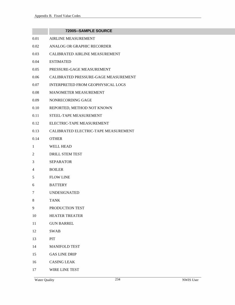
Appendix B. Fixed Value Codes
Water Quality NWIS User
234
72005--SAMPLE SOURCE
0.01 AIRLINE MEASUREMENT
0.02 ANALOG OR GRAPHIC RECORDER
0.03 CALIBRATED AIRLINE MEASUREMENT
0.04 ESTIMATED
0.05 PRESSURE-GAGE MEASUREMENT
0.06 CALIBRATED PRESSURE-GAGE MEASUREMENT
0.07 INTERPRETED FROM GEOPHYSICAL LOGS
0.08 MANOMETER MEASUREMENT
0.09 NONRECORDING GAGE
0.10 REPORTED, METHOD NOT KNOWN
0.11 STEEL-TAPE MEASUREMENT
0.12 ELECTRIC-TAPE MEASUREMENT
0.13 CALIBRATED ELECTRIC-TAPE MEASUREMENT
0.14 OTHER
1 WELL HEAD
2 DRILL STEM TEST
3 SEPARATOR
4 BOILER
5 FLOW LINE
6 BATTERY
7 UNDESIGNATED
8 TANK
9 PRODUCTION TEST
10 HEATER TREATER
11 GUN BARREL
12 SWAB
13 PIT
14 MANIFOLD TEST
15 GAS LINE DRIP
16 CASING LEAK
17 WIRE LINE TEST

Appendix B. Fixed Value Codes
Water Quality NWIS User
235
72005--SAMPLE SOURCE
18 HEADER
19 FILTER
20 TEST TOOL
21 LTX UNIT
22 KNOCKOUT
23 WELL BLEEDER
24 FRACTURE TEST
25 TEST WAGON
26 PUMP
27 TAP NEAR WELL
28 TAP AWAY FROM WELL
29 BUCKET
30 PRESSURE TANK
31 DISCHARGE PIPE
32 FOERST SAMPLER
33 BAILER
34 DRAIN LINE
35 INJECTION PUMP
36 SPOT SAMPLE IN FLUID COLUMN
37 TANK BATTERY INCLUDING GUN BARREL
38 WINDMILL
39 WATER SIPHON
40 SPECIAL
41 MUNICIPAL AND DOMESTIC WASTE
42 INDUSTRIAL WASTE
43 STORM WATER (PRIOR TO ENTERING NATURAL CHANNELS)
44 PUBLIC WATER SUPPLIES (TREATED WATER)
45 MINE WATER
46 PUBLIC WATER SUPPLIES (UNTREATED WATER)
47 WATER WELL
48 MULTIPLE WATER WELLS

Appendix B. Fixed Value Codes
Water Quality NWIS User
236
72005--SAMPLE SOURCE
49 OIL WELL
50 MULTI-OIL WELL
51 GAS WELL
52 MULTI-GAS WELL
53 OIL AND GAS WELL
54 MULTI-OIL AND GAS WELL
55 DRILLED AND ABANDONED WELL
56 PLUGGED AND ABANDONED WELL
57 JUNKED AND ABANDONED WELL
58 TEMPORARILY ABANDONED WELL
59 ABANDONED OIL WELL
60 ABANDONED GAS WELL
61 SALT-WATER SUPPLY WELL
62 SALT-WATER DISPOSAL WELL
63 INJECTION WELL
64 SERVICE WELL
65 WETLAND ECOSYSTEM
66 DREDGE WAKE
67 MAINSTREAM
68 OVERBANK
69 COMPOSITED PUBLIC WATER SUPPLY(UNTREATED WATER)
70 COMPOSITED PUBLIC WATER SUPPLY(TREATED WATER)
72 INTERSTITIAL WATER
74 LYSIMETER
76 OIL OR GAS TEST WELL CONVERTED TO WATER WELL
77 SURFICIAL BANK
78 INTERIOR BANK
79 BEFORE PRESSURE TANK
80 AFTER PRESSURE TANK
86 HYPORHEIC ZONE
88 SEEPAGE METER

Appendix B. Fixed Value Codes
Water Quality NWIS User
237
72005--SAMPLE SOURCE
100 DOMESTIC SUPPLY-UNTREATED
110 DOMESTIC SUPPLY-TREATED
1001 WET DEPOSITION
1002 DUSTFALL
1003 LANDFILL
1004 CAST OVERBURDEN
1005 STREET SWEEPING
1006 LANDFILL SEEP
72006--SAMPLING CONDITION
0.01 THE SITE WAS DRY (NO WATER LEVEL IS RECORDED)
0.02 THE SITE HAD BEEN FLOWING RECENTLY
0.03 THE SITE WAS FLOWING, HEAD COULD NOT BE MEASURED
0.04 A NEARBY SITE THAT TAPS THE AQUIFER WAS FLOWING
0.05 NEARBY SITE TAPPING SAME AQUIFER HAD BEEN FLOWING RECENTLY
0.06 INJECTOR SITE
0.07 INJECTOR SITE MONITOR
0.08 MEASUREMENT DISCONTINUED
0.09 OBSTRUCTION ENCOUNTERED IN WELL ABOVE WATER SURFACE
0.10 THE SITE WAS BEING PUMPED
0.11 THE SITE HAD BEEN PUMPED RECENTLY
0.12 NEARBY SITE TAPPING THE SAME AQUIFER WAS BEING PUMPED
0.13 NEARBY SITE TAPPING THE SAME AQUIFER WAS PUMPED RECENTLY
0.14 FOREIGN SUBSTANCE PRESENT ON THE SURFACE OF THE WATER
0.15 WELL DESTROYED
0.16 WATER LEVEL AFFECTED BY STAGE IN NEARBY SITE
0.17 OTHER CONDITIONS AFFECTING THE MEASURED WATER LEVEL
1 TESTING
2 UNDESIGNATED
3 SWABBING
4 FLOWING
5 REVERSING OUT

Appendix B. Fixed Value Codes
Water Quality NWIS User
238
72006--SAMPLING CONDITION
6 FLOWING ON GAS LIFT
7 AFTER ACIDIZING
8 PUMPING
9 MILLIPORE FILTER
10 OPEN HOLE
11 FLOWING ON DRILL STEM TEST
12 AFTER DRILL STEM TEST
15 BAILING
16 AFTER PERFORATION
17 TUBING FLOW
18 PRODUCING
19 CIRCULATING
20 FLOWING ON PRODUCTION TEST
21 FLOWING ON POTENTIAL TEST
22 LIFTING
23 FLOWING TO PIT
24 WATER FLOODING
25 JETTING
26 PRODUCTION AND DEVELOPMENT TEST
27 PRODUCTION BY UNKNOWN METHOD
30 SEEPING
31 NEARBY WELL PUMPING
32 NEARBY WELL TAKING WATER
33 WELL TAKING WATER
74200--SAMPLE PRESERVATION METHOD
1 FA, Polyethylene bottle, 250 mL, acid rinsed; 0.45-µm filter, pH<2 with HNO3
3 FAB, Teflon bottle, 250 ml, acid rinsed; 0.45-µm filter, pH<2 with HNO3
5 FAR, Polyethylene bottle, 1L, acid rinsed; 0.45-µm filter, pH<2 with Ultrex HNO3
7 FC, Brown polyethylene bottle, container size dependent on laboratory schedule; field rinsed, 0.45-µm filter, chill
9 FU, POLY BOTTLE, FIELD RINSED
11 RA, Polyethylene bottle, acid-rinsed, 250 mL; field rinsed, pH<2 with HNO3

Appendix B. Fixed Value Codes
Water Quality NWIS User
239
74200--SAMPLE PRESERVATION METHOD
13 RAB, TEFLON BOTTLE, ACID RINSED, 250 ML
15 RAE, Polyethylene bottle, acid-rinsed, 250 mL; field rinsed, pH<2 with HNO3
17 RAH, Polyethylene bottle, acid-rinsed, 250 mL; field rinsed, pH<2 with HNO3
19 RC, BROWN POLY BOTTLE, FIELD RINSED, 250 ML
21 RU, Polyethylene bottle, size dependent on analyses requested; field rinsed.
23 RUR, Polyethylene bottle, polyseal cap, 250 mL, 500 mL, or 1L ; field rinsed
25 LC0023 or RCN, Polyethylene bottle, 250 mL; field rinsed, ph>12 with NaOH, chill
27 LC0076 or COD, Glass bottle, 125 mL, baked at 450 deg C; pH<2 with H2SO4; chill; do not rinse
29 LC0089, Polyethylene bottle, 250 mL; field rinsed, 0.5 g zinc acetate
31 LC0239, POLY BOTTLE, ACID RINSED, 1 L
33 LC0298, Contact NWQL
35 LC0300, GLASS BOTTLE, FIELD RINSED, 250 ML
39 LC0439, STEEL BARREL
41 LC0440, Glass bottle, narrow-neck, polyethylene seal cap, 1L; field rinsed, unfiltered, add 50mL SrCl2, seal with tape
43 LC0452, Polyethylene bottle, polyethylene seal cap, 125 mL; field rinsed, unfiltered
45 LC0489, Glass or polyethylene bottle, 125 mL; Contact Ty Coplen (703-648-5862)
47 LC0490, Contact NWQL
49 LC0491, Contact NWQL
51 LC0880 or FCN, Polyethylene bottle, 250 mL; 0.45-µm filter, NaOH to pH>12, chill
53 LC0995, Contact NWQL
55 LC0996, GLASS BOTTLE, FIELD RINSED
57 LC0997, Contact NWQL
59 CL, SEPTUM BOTTLE, 40 ML
61 GCC, Amber glass bottle, baked at 450 degrees C, 1 L; do not rinse, chill.
63 GCV, Amber glass septum vial, 40 mL; do not rinse, see section 8 of USGS OFR 97-829.
65 RCB, Polyethylene bottle, 250 mL; field rinsed, chill (Same as 79 - below)
67 LC0052 or PHE, Glass bottle, baked, 500 mL; do not rinse; dechlorinate with 100 mg of ferrous sulfate ph<2 with H2SO4, chill
69 LC0113 or DOC, Amber glass bottle, baked at 450 degrees C, 125 mL; rinse with organic-free water only, use Gelman filter, ph<2 with H2SO4, chill, See OWQ memo 2000.05
71 LC0114 or TOC, Amber glass bottle, baked at 450 degrees C, 125 mL; do not rinse, chill

Appendix B. Fixed Value Codes
Water Quality NWIS User
240
74200--SAMPLE PRESERVATION METHOD
73 LC0127, Amber oil and grease bottle, baked at 450 degrees C, 1 L; do not rinse, pH<2 with H2SO4, chill
75 LC0305 or SOC, 0.45-µm silver filter in a petri dish; rinse filter with organic-free water prior to collecting sample, record filtered volume on petri dish, chill
77 FU, Polyethylene bottle, container size dependent on laboratory schedule; field rinsed, 0.45-µm filter
79 RCB, Polyethylene bottle, 250 mL; field rinsed, chill (Same as 65 - above)
81 RU, POLY BOTTLE, FIELD RINSED, 500 ML
83 LC0050 or TBY, Polyethylene bottle, 125 mL; field rinsed
85 LC0169 or SUSO, Polyethylene bottle, 500 ML; field rinsed
87 CC, PLASTIC FREEZER CARTON, 1 PT
89 CU, PLASTIC FREEZER CARTON, 1 PT
91 BGC, WIDE MOUTH GLASS BOTTLE, 1 L
93 CC, PLASTIC FREEZER CARTON, 1 PT
95 PP, Contact NWQL
97 SIZE, UNTREATED
99 BEN, POLY BOTTLE, WIDE MOUTH
101 CHE, GLASS JAR, WIDE MOUTH
103 CHY, GLASS VIAL
105 DIA, CONTACT ATLANTA CENTRAL LABORATORY
107 PER, CONTACT ATLANTA CENTRAL LABORATORY
109 SHY, POLY BOTTLE
111 ST, POLY BOTTLE
113 ZOO, CONTACT ATLANTA CENTRAL LABORATORY
115 LC0055, POLY BOTTLE
117 LC0438, Contact NWQL
119 LC0616, GLASS VIAL
121 LC1049, WIDE MOUTH GLASS BOTTLE, 1 L
123 FAM, Glass bottle, acid rinsed, 250 mL; 0.45-µm filter, 2mL of HCl, See NWQL Memo 2001.01
125 FCU, BROWN POLY BOTTLE, FIELD RINSED, 250 ML
127 RAM, Glass bottle, acid-rinsed, 250 mL; field rinsed, 2mL of 6N ultrapure HCl, See NWQL Memo 2001.01
129 LCO460, POLY BOTTLE, FIELD RINSED, 500 ML
131 LCO881, POLY BOTTLE, FIELD RINSED, 125 ML

Appendix B. Fixed Value Codes
Water Quality NWIS User
241
74200--SAMPLE PRESERVATION METHOD
133 LC1043, Glass or high-density polyethylene bottle, polyethylene seal cap, 1 L; field rinsed, untreated
135 LC1199, Contact NWQL
137 LC0019, Amber glass bottle, baked at 450 degrees C, 125 mL; do not rinse, chill.
139 LC0306, GLASS BOTTLE, 125 ML
141 LC1038, PLASTIC FREEZER CARTON, 1 PT
143 LC0961, Contact NWQL
145 ALF, Aluminum foil
147 C18, C-18 SPE Cartridge; See field instructions
149 CC, Polypropylene bottle, 500 mL, wide-mouthed; field sieve through 2-mm plastic sieve, chill.
151 CRB, Carbopak-B Cartridge; See field instructions
153 CUR, Polyethylene bottle, 500 mL, wide mouth; no treatment
155 EAM, Amber glass bottle, 250 mL; ph<2 with HNO3
157 EBC, Amber glass bottle, 1L, Teflon cap liner; dechlorinate, ph<2 with HCl chill
159 ECC, Amber glass bottle, 1L, Teflon cap liner; dechlorinate, chill
161 EDV, Amber glass screw-cap vials, 40 mL, Teflon-lined septa; dechlorinate, chill
163 ELV, Glass screw-cap vials, 60 mL, Teflon-faced silicone septa; pH=3 with monochloroacetic acid, dechlorinate, chill
165 EOV, Amber glass screw-cap vial, 40 mL, Teflon-lined septa; dechlorinate, 2 drops of HCl:H2O supplied by NWQL, chill
167 EPC, High-density poly-vinyl chloride (PVC) bottles, 1L; dechlorinate, pH=2 with H2SO4 if biologically active, chill.
169 ERA, Polyethylene bottle, 500 mL; EPA SDWA, pH<2 with HNO3
171 ERC, Amber polyethylene bottle, 125 mL; EPA SDWA, Raw sample, chill
173 ERU, Polyehtylene bottle, 250 mL; EPA SDWA, Raw sample
175 FCA, Brown polyethylene bottle, 125 mL; 0.45-µm filter, 1mL of 4.5N H2SO4, chill
177 FCC, Brown polyethylene bottle, 125 mL; 0.45-µm filter, chill
179 FUS, Filtered untreated stable isotopes; treatment dependent on services requested.
181 IQE, Invertebrate QMH Elutriate; see NWQL Tech Memo 98-09
183 IQL, Invertebrate QMH Large Rare; see NWQL Tech Memo 98-09
185 IQM, Invertebrate QMH Main Body; see NWQL Tech Memo 98-09
187 IRE, Invertebrate RTH Elutriate; see NWQL Tech Memo 98-09
189 IRL, Invertebrate RTH Large Rare; see NWQL Tech Memo 98-09
191 IRM, Invertebrate RTH Main Body; see NWQL Tech Memo 98-09

Appendix B. Fixed Value Codes
Water Quality NWIS User
242
74200--SAMPLE PRESERVATION METHOD
193 LC0460, Polyethylene bottle, polyethylene seal cap, 250mL; field rinsed, untreated
195 LC0624, Polyethylene bottle, polyethylene seal cap, 500 mL; field rinsed, untreated
197 LC1565, Glass or high-density polyethylene bottle, polyethylene seal cap, 1L; field rinsed, untreated
199 LC1567, Polyethylene bottle, polyethylene seal cap, 125 mL; field rinsed, untreated
201 LC1574, Glass or high-density polyethylene bottle, polyethylene seal cap, 125 mL; Contact Ty Coplen (703-648-5862)
203 LC1717 or LC1718, Amber glass or high-density polyethylene bottle, narrow neck, polyethylene seal cap, 1L; field rinsed, wrap poly bottle in aluminum foil, chill
205 LC1949, Contact Ty Coplen (703-648-5862)
207 LC1951, Glass or untreated high-density polyethylene bottle, narrow neck, polyethylene seal cap, 1L; field rinse
209 MBAS, Polyethylene bottle, 250 mL; field rinse, chill
211 PIC, Glass fiber filter; fold filter in half, aluminum foil pouch, Whirlpak bag, chill, include sampled volume
213 RAR, Polyethylene bottle, acid-rinsed, 1L; field rinsed, pH<2 with HNO3
215 RCA, Brown polyethylene bottle, 125 mL; field rinsed, acidify with H2SO4, chill (Discontinued: See OWQ 99.004)
217 RCC, Brown polyethylene bottle, 125 mL; field rinsed, chill (Discontinued: See OWQ 99.004)
219 RURCT, Copper tube, 1L; See NWQL Tech memo 97.04 and 97.04S
221 RURCV, Glass vial, 20mL; 10 mL mineral oil, must be received within 48 hours of collection
223 RUS, Polyethylene bottle, 250 mL, 500 mL, or 1L; field rinsed, Contact Ty Coplen (703-648-5862)
225 SC1379, Amber glass bottle, baked at 450 degrees C, 125 mL; do not rinse, filter through 0.7-µm in-line filter, chill
227 SUR, Petri dish or vial; filter
229 TBI, ziplock-type bag, glass or polyethylene wide-mouth jar
231 TPCN, Glass fiber filter, 25 mm; fold filter in half, aluminum foil pouch, Whirlpak bag, chill, include sampled volume
233 UAS, Supor or glass fiber filter and Amber glass septum vial, 40 mL; chill
235 WCA, Polyethylene bottle, 125 mL; field rinsed, 1mL of 4.5 N H2SO4, chill
237 LC1648, Polyethylene bottle, 250 mL; field rinsed, ph>12 with NaOH, chill
82309--CONTAMINATION SOURCE, POSSIBLE
1 OIL SPILL
3 GAS SPILL
5 ORGANIC
7 PESTICIDE
9 HERBICIDE

Appendix B. Fixed Value Codes
Water Quality NWIS User
243
82309--CONTAMINATION SOURCE, POSSIBLE
11 INSECTICIDE
13 FEEDLOT RUNOFF
15 SALT WATER
17 INJECTION WELL
19 SEWAGE TREATMENT PLANT
21 LAND SPREADING
23 LANDFILL
25 SLUDGE DUMP
27 WASTE LAGOON
29 URBAN RUNOFF
31 MINE DRAINAGE
33 CONSTRUCTION DRAINAGE
35 PULP MILL OUTFALL
37 TEXTILE MILL OUTFALL
39 IRRIGATION RUNOFF
41 FERTILIZER
43 DAIRY OPERATION
82398--SAMPLING METHOD
10 EQUAL WIDTH INCREMENT (EWI)
20 EQUAL DISCHARGE INCREMENT (EDI)
25 TIMED SAMPLING INTERVAL
30 SINGLE VERTICAL
40 MULTIPLE VERTICALS
50 POINT SAMPLE
55 COMPOSITE – MULTIPLE POINT SAMPLES
60 WEIGHTED BOTTLE
70 GRAB SAMPLE
80 DISCHARGE INTEGRATED, EQUAL TRANSIT RATE (ETR)
90 DISCHARGE INTEGRATED, CENTROID
100 VAN DORN SAMPLER
110 SEWAGE SAMPLER

Appendix B. Fixed Value Codes
Water Quality NWIS User
244
82398--SAMPLING METHOD
120 VELOCITY INTEGRATED
130 SEEPAGE METER
200 ZOOPLANKTON-NET
210 BENTHIC INVERTEBRATE-MECHANICAL GRAB
220 BENTHIC INVERTEBRATE-MECHANICAL DREDGE
230 BENTHIC INVERTEBRATE-ARTIFICIAL SUBSTRATE
240 BENTHIC INVERTEBRATE-NATURAL SUBSTRATE
250 BENTHIC INVERTEBRATE-NET
260 PHYTOPLANKTON-NET
270 PHYTOPLANKTON-WATER BOTTLE
280 PERIPHYTON-NATURAL SUBSTRATE
281 PERIPHYTON – NATURAL SUBSTRATE, DEPOSITIONAL TARGETED HABITAT
282 PERIPHYTON – NATURAL SUBSTRATE, RICHEST TARGETED HABITAT
290 PERIPHYTON – ARTIFICIAL SUBSTRATE
900 SUSPENDED SEDIMENT; PUMPING – STREAM SAMPLE USING A PUMPING MECHANISM
910 SUSPENDED SEDIMENT; SINGLE-STAGE, NOZZLE AT FIXED STAGE, PASSIVELY FILLING
920 SUSPENDED SEDIMENT; BOX SINGLE VERTICAL, DEPTH-INT, ATTACHED TO STRUCTURE
930 SUSPENDED SEDIMENT; PARTIAL DEPTH, DEPTH INTEGRATED, PART OF SINGLE VERTICAL
940 SUSPENDED SEDIMENT; PARTIAL WIDTH – DEPTH/WIDTH INTEGRATED, PART OF X-SECTION
1000 BEDLOAD, SINGLE EQUAL WIDTH INCREMENT (SEWI)
1010 BEDLOAD, MULTIPLE EQUAL WIDTH INCREMENT (MEWI)
1020 BEDLOAD, UNEQUAL WIDTH INCREMENT (UWI)
4010 THIEF SAMPLE
4020 OPEN-TOP BAILER
4025 DOUBLE-VALVE BAILER
4030 SUCTION PUMP
4031 SUCTION LIFT CENTRIFUGAL PUMP
4032 SUCTION LIFT JET PUMP
4033 SUCTION LIFT PERISTALTIC PUMP
4040 SUBMERSIBLE PUMP
4041 SUBMERSIBLE BLADDER PUMP

Appendix B. Fixed Value Codes
Water Quality NWIS User
245
82398--SAMPLING METHOD
4042 SUBMERSIBLE GAS RECIPROCATING PUMP
4043 SUBMERSIBLE GAS LIFT PUMP
4044 SUBMERSIBLE JET PUMP
4045 SUBMERSIBLE MULTIPLE IMPELLER (TURBINE) PUMP
4046 SUBMERSIBLE HELICAL ROTOR PUMP
4047 SUBMERSIBLE GEAR PUMP
4048 SUBMERSIBLE GAS-DISPLACEMENT PUMP
4050 SQUEEZE PUMP
4060 GAS RECIPROCATING PUMP
4070 GAS LIFT
4080 PERISTALTIC PUMP
4090 JET PUMP
4100 FLOWING WELL
4110 RESIN TRAP COLLECTOR
5010 SEDIMENT CORE
8010 OTHER
8020 SYRINGE SAMPLE
8030 GRAB SAMPLE AT WATER-SUPPLY TAP
82923--ATMOSPHERIC DEPOSITION TYPE, WET
1 SNOW
2 HAIL
3 MIXTURE (RAIN, SNOW, AND OR HAIL)
4 RAIN
9.99 UNKNOWN
83205--ATMOSPHERIC DEPOSITION TYPE, BULK
1 SNOW 2 HAIL 3 MIXTURE (RAIN, SNOW, AND OR HAIL) 4 RAIN 9.99 UNKNOWN 84060--TOPOGRAPHY, PHYSIOGRAPHIC SETTING
10 ALLUVIAL FAN

Appendix B. Fixed Value Codes
Water Quality NWIS User
246
84060--TOPOGRAPHY, PHYSIOGRAPHIC SETTING
20 PLAYA
30 STREAM CHANNEL
40 LOCAL DEPRESSION
50 DUNES
60 FLAT SURFACE
70 FLOOD PLAIN
80 HILLTOP
90 SINKHOLE
100 LAKE, SWAMP, OR MARSH
110 MANGROVE SWAMP
120 OFFSHORE (ESTUARY)
130 PEDIMENT
140 HILLSIDE (SLOPE)
150 TERRACE, ALLUVIAL OR MARINE
160 UNDULATING
170 VALLEY FLAT
180 UPLAND DRAW
84143--WELL PURGING CONDITION
100 WELL PURGED TO STABLE PH
110 WELL PURGED TO STABLE TEMPERATURE
120 WELL PURGED TO STABLE SPECIFIC CONDUCTANCE
130 WELL PURGED TO STABLE PH AND TEMPERATURE
140 WELL PURGED TO STABLE PH AND SPECIFIC CONDUCTANCE
150 WELL PURGED TO STABLE TEMPERATURE AND SPECIFIC CONDUCTANCE
160 WELL PURGED TO STABLE PH, TEMP. AND SPECIFIC CONDUCTANCE
170 WELL PURGED, AT LEAST THREE WELL VOLUMES
500 WELL NOT PURGED, WATER IN CASING LESS THAN 6 HOURS
510 WELL NOT PURGED, WATER IN CASING 6-12 HOURS
520 WELL NOT PURGED, WATER IN CASING 12-24 HOURS
530 WELL NOT PURGED, WATER IN CASING MORE THAN 24 HOURS

Appendix B. Fixed Value Codes
Water Quality NWIS User
247
84144--WELL SELECTION CRITERIA
100 SITE SELECTED BECAUSE IT IS NEAR/WITHIN LOCAL PROBLEM AREA
200 SITE SELECTED WITHOUT REGARD TO LOCAL PROBLEM AREA
84145--PROJECT COMPONENT
100 REGIONAL SAMPLING
200 TARGETED SAMPLING (AGRICULTURAL AREA)
300 TARGETED SAMPLING (URBAN OR SUBURBAN AREA)
400 TARGETED SAMPLING (NATURALLY OCCURRING SUBSTANCES)
500 TARGETED SAMPLING (LOCAL-SCALE NETWORK)
600 TARGETED SAMPLING (OTHER)
700 GEOCHEMICAL INVESTIGATION
84146--LAND USE, PREDOMINANT, WITHIN 100 FT OF WELL
110 RESIDENTIAL
120 COMMERCIAL AND SERVICES
130 INDUSTRIAL
170 OTHER URBAN OR BUILT-UP LAND
211 NONIRRIGATED CROPLAND
212 IRRIGATED CROPLAND
213 PASTURE
220 ORCHARDS, GROVES, VINEYARDS, NURSERIES
230 CONFINED FEEDING OPERATIONS
240 OTHER AGRICULTURAL LAND
300 RANGELAND
400 FORESTLAND
500 WATER
600 WETLAND
700 BARREN LAND
84147--LAND USE, PREDOMINANT, WITHIN 1/4 MILE RADIUS OF WELL
110 RESIDENTIAL
120 COMMERCIAL AND SERVICES
130 INDUSTRIAL
170 OTHER URBAN OR BUILT-UP LAND

Appendix B. Fixed Value Codes
Water Quality NWIS User
248
84147--LAND USE, PREDOMINANT, WITHIN 1/4 MILE RADIUS OF WELL
211 NONIRRIGATED CROPLAND
212 IRRIGATED CROPLAND
213 PASTURE
220 ORCHARDS, GROVES, VINEYARDS, NURSERIES
230 CONFINED FEEDING OPERATIONS
240 OTHER AGRICULTURAL LAND
300 RANGELAND
400 FORESTLAND
500 WATER
600 WETLAND
700 BARREN LAND
84148--LAND USE, PREDOMINANT FRACTION, WITHIN 1/4 MILE RADIUS OF WELL
25 LESS THAN 25 PERCENT
50 FROM 26 PERCENT TO 50 PERCENT
75 FROM 51 PERCENT TO 75 PERCENT
100 FROM 76 PERCENT TO 100 PERCENT
84149--LAND-USE CHANGES W/I LAST 10 YRS, WITHIN 1/4 MILE RADIUS OF WELL
100 YES
200 PROBABLY
300 PROBABLY NOT
400 NO
84164--SAMPLER TYPE
100 VAN DORN SAMPLER
110 SEWAGE SAMPLE
120 VELOCITY INTEGRATED SAMPLE
125 KEMMERER BOTTLE
130 DRUM SEEPAGE METER (LEE, 1977)
200 ZOOPLANKTON NET
210 BENTHIC INVERTEBRATE-MECHANICAL, GRAB
220 BENTHIC INVERTEBRATE-MECHANCIAL, DREDGE
230 BENTHIC INVERTEBRATE-ARTIFICIAL SUBSTRATE

Appendix B. Fixed Value Codes
Water Quality NWIS User
249
84164--SAMPLER TYPE
240 BENTHIC INVERTEBRATE-NATURAL SUBSTRATE
250 BENTHIC INVERTEBRATE-NET
260 PHYTOPLANKTON NET
270 PHYTOPLANKTON-WATER BOTTLE
280 PERIPHYTON-NATURAL SUBSTRATE
290 PERIPHYTON-ARTIFICIAL SUBSTRATE
1000 BEDLOAD-HELLEY-SMITH, 3 X 3, AREA RATIO 3.22
1010 BEDLOAD-HELLEY-SMITH, 6 X 6, AREA RATIO 3.22
1020 BEDLOAD-HELLEY-SMITH, 3 X 3, AREA RATIO 1.40
1030 BEDLOAD-HELLEY-SMITH, 6 X 6, AREA RATIO 1.40
1040 BEDLOAD-HELLEY-SMITH, 6 X 12, AREA RATIO 1.40
1050 BEDLOAD-TOUTLE RIVER TYPE 2, 6 X 12, AREA RATIO 1.40
1060 BEDLOAD-BL-84, 3 X 3, AREA RATION, 1.40
1070 BEDLOAD-TOUTLE RIVER TYPE 1, 6 X 6, AREA RATIO 3.22
1080 BEDLOAD-HUBBLE #5, 6 X 12, AREA RATIO, 1.40
1090 FIASP, 3 X 3, AREA RATIO 1.40
1100 3X3 INCH H-S, 1/4-IN THICK NOZZLE, 50-100 LBS, CABLE SUSP
1110 3X3 INCH H-S, 1/4-IN THICK NOZZLE, 100-200 LBS, CABLE SUSP
1120 3X3 INCH H-S, 1/4-INCH THICK NOZZLE, WADING
1130 3X3 INCH H-S, SHEET METAL NOZZLE, WADING
1140 3X3 INCH FIASP, 1/4-IN THICK NOZZLE, 50-100LBS, CABLE SUSP
1150 3X3 INCH FIASP, 1/4-INCH THICK NOZZLE, WADING
1160 3X3 INCH FIASP, SHEET METAL NOZZLE, WADING
1170 6X6 IN H-S, 1/4-IN THICK NOZZLE, 150-200 LBS, CABLE SUSP
3001 SAMPLER, US DH-48
3002 SAMPLER, US DH-59
3003 SAMPLER, US DH-75P
3004 SAMPLER, US DH-75Q
3005 SAMPLER, US DH-76
3006 SAMPLER, US D-43
3007 SAMPLER, US D-49

Appendix B. Fixed Value Codes
Water Quality NWIS User
250
84164--SAMPLER TYPE
3008 SAMPLER, US D-49AL
3009 SAMPLER, US D-74
3010 SAMPLER, US D-74AL
3011 SAMPLER, US D-77
3012 SAMPLER, US P-46
3013 SAMPLER, US P-50
3014 SAMPLER, US P-61-A1
3015 SAMPLER, US P-63
3016 SAMPLER, US P-72
3017 SAMPLER, US U-59
3018 SAMPLER, US U-73
3019 SAMPLER, US PS-69
3020 SAMPLER, US PS-69TM
3021 SAMPLER, US CS-77
3022 SAMPLER, US PS-82
3023 SAMPLER, US BMH-53
3024 SAMPLER, US BMH-53TM
3025 SAMPLER, US BM-54
3026 SAMPLER, US BM-54TM
3027 SAMPLER, US BMH-60
3028 SAMPLER, US BMH-60TM
3029 SAMPLER, US RBM-80
3030 US DH-48 TM
3031 US DH-48 TM W/ TEFLON GASKET AND NOZZLE
3032 US DH-59 TM
3033 US DH-59 TM W/ TEFLON GASKET AND NOZZLE
3034 US DH-76 TM
3035 US DH-76 TM W/ TEFLON GASKET AND NOZZLE
3036 US D-74 TM
3037 US D-74 AL-TM
3038 US D-74 AL-TM W/ TEFLON GASKET AND NOZZLE

Appendix B. Fixed Value Codes
Water Quality NWIS User
251
84164--SAMPLER TYPE
3039 US D-77 TM
3040 US D-77 TM MODIFIED TEFLON BAG SAMPLER
3041 US P-61 AL-TM
3042 US P-61
3043 US P-61 TM
3044 US DH-81
3045 US DH-81 WITH TEFLON CAP AND NOZZLE
3046 SAMPLER, D-77 TM, W/REYNOLDS OVEN COLLAPSIBLE BAG
3047 SAMPLER, FRAME-TYPE, PLASTIC BOTTLE W/REYNOLDS OVEN BAG
3048 SAMPLER, FRAME-TYPE, TEFLON BOTTLE
3049 SAMPLER, FRAME-TYPE, PLASTIC BOTTLE
3050 SAMPLER, FRAME-TYPE, PLASTIC BOTTLE W/TEFLON COLLAPS. BAG
3051 US DH-95 TEFLON BOTTLE
3052 US DH-95 PLASTIC BOTTLE
3053 US D-95 TEFLON BOTTLE
3054 US D-95 PLASTIC BOTTLE
3055 US D-96 BAG SAMPLER
3056 US D-96-A1 BAG SAMPLER
3060 WEIGHTED-BOTTLE SAMPLER
3061 US WBH-96 WEIGHTED-BOTTLE SAMPLER
3070 GRAB SAMPLE
3071 OPEN-MOUTH BOTTLE
3080 VOC HAND SAMPLER
4010 THIEF SAMPLER
4020 OPEN-TOP BAILER
4025 DOUBLE-VALVE BAILER
4030 SUCTION PUMP
4035 SUBMESIBLE CENTRIFUGAL PUMP
4040 SUBMERSIBLE POSITIVE-PRESSURE PUMP
4041 SUBMERSIBLE HELICAL ROTOR PUMP
4045 SUBMERSIBLE GEAR PUMP

Appendix B. Fixed Value Codes
Water Quality NWIS User
252
84164--SAMPLER TYPE
4050 BLADDER PUMP
4055 INERTIAL PUMP
4060 GAS RECIPROCATING PUMP
4070 GAS LIFT
4075 SUBMERSIBLE PISTON PUMP
4080 PERISTALTIC PUMP
4090 JET PUMP 4095 LINE-SHAFT TURBINE PUMP 4100 FLOWING WELL
4110 RESIN TRAP COLLECTOR
4115 SAMPLER, POINT, AUTOMATIC
5010 BOX CORE, LONG
5020 BOX CORE, SHORT
5030 GRAVITY CORE
5040 PISTON CORE
5050 PUSH CORE
8000 NONE
8010 OTHER
91112--LATITUDE/LONGITUDE HORIZONTAL DATUM
27 NORTH AMERICAN DATUM OF 1927 (GWSI C36 VALUE – NAD27)
83 NORTH AMERICAN DATUM OF 1983 (GWSI C36 VALUE – NAD83)
100 OLD ALASKA (MAINLAND) AND ALEUTIAN ISLANDS DATUM (GWSI C36 VALUE – OLDAK)
110 OLD HAWAII (GWSI C36 VALUE – OLDHI)
120 OLD PUERTO RICO AND VIRGIN ISLANDS DATUM (GWSI C36 VALUE – OLDPR)
130 OLD AMERICAN SAMOA DATUM (GWSI C36 VALUE – OLDSAMOA)
140 OLD GUAM DATUM (GWSI C36 VALUE – OLDGUAM)
91113--LATITUDE/LONGITUDE MEASUREMENT METHOD
10 CALCULATED FROM LAND NET (GWSI C35 VALUE – C)
20 DIFFERENTIALLY CORRECTED GLOBAL POSITIONING SYSTEM (GPS) (GWSI C35 VALUE – D)
30 GLOBAL POSITIONING SYSTEM, UNCORRECTED (STANDARD POSITIONING SERVICE (SPS) AND PRECISE POSITIONING SERVICE (PPS)) (GWSI C35 VALUE – G)
40 LONG-RANGE NAVIGATION SYSTEM (GWSI C35 VALUE – L)

Appendix B. Fixed Value Codes
Water Quality NWIS User
253
91113--LATITUDE/LONGITUDE MEASUREMENT METHOD
50 INTERPOLATED FROM MAP (GWSI C35 VALUE – M)
60 INTERPOLATED FROM DIGITAL MAP (GWSI C35 VALUE – N)
70 REPORTED (GWSI C35 VALUE – R)
80 TRANSIT, THEODOLITE, OR OTHER SURVEYING METHOD (GWSI C35 VALUE – S)
99 UNKNOWN (GWSI C35 VALUE – U)
91114--LATITUDE/LONGITUDE COORDINATE ACCURACY
1 ACCURATE TO +/- 1 SECOND (GWSI C11 VALUE – S)
3 ACCURATE TO +/- 3 SECONDS (STANDARD POSITIONING SERVICE (SPS GPS)) (GWSI C11 VALUE – R)
5 ACCURATE TO +/- 5 SECONDS (GWSI C11 VALUE – F)
10 ACCURATE TO +/- 10 SECONDS (GWSI C11 VALUE – T)
60 ACCURATE TO +/- 1 MINUTE (GWSI C11 VALUE – M)
99 UNKNOWN (GWSI C11 VALUE – U)
99100--BLANK, TYPE OF SOLUTION
10 DISTILLED/DEIONIZED WATER
20 STANDARD REFERENCE WATER SAMPLE
30 MATCHED MATRIX
40 ORGANIC-FREE WATER
50 VOC FREE WATER
60 STERILE SALINE BUFFERED WATER
70 STERILE BUFFERED WATER PO4/MgC12
80 UNIVERSAL BLANK WATER
200 OTHER
99101--BLANK, SOURCE OF SOLUTION
10 NATIONAL WATER QUALITY LAB (USGS)
20 U.S. ENVIRONMENTAL PROTECTION AGENCY
30 STANDATD REFERENCE WATER SAMPLE (USGS)
35 MIX OF STANDARD REFERENCE WATER SAMPLE
40 NIST (FORMERLY NBS)
50 CANADIAN INLAND WATERS
55 USGS MERCURY RESEARCH LAB (WISCONSIN DISTRICT)
60 DISTRICT LAB

Appendix B. Fixed Value Codes
Water Quality NWIS User
254
99101--BLANK, SOURCE OF SOLUTION
61 SUBDISTRICT #1 LAB
62 SUBDISTRICT #2 LAB
63 SUBDISTRICT #3 LAB
64 SUBDISTRICT #4 LAB
70 NATURAL SAMPLE
71 FIELD OFFICE #1 LAB
72 FIELD OFFICE #2 LAB
73 FIELD OFFICE #3 LAB
74 FIELD OFFICE #4 LAB
80 OCALA LAB (USGS)
99.99 UNKNOWN
100 CHEMICAL SUPPLIER
110 BURDICK AND JACKSON
120 J.T. BAKER
200 OTHER
99102--BLANK, TYPE OF SAMPLE
1 SOURCE SOLUTION
10 SHELF (HOLD)
20 REFRIGERATOR
30 TRIP
40 SAMPLER
50 SPLITTER
60 FILTER
70 PRESERVATION
80 EQUIPMENT
90 AMBIENT
100 FIELD
150 LAB BLANK
200 OTHER
99103--REFERENCE MATERIAL, SOURCE
10 NATIONAL WATER QUALITY LAB (USGS)

Appendix B. Fixed Value Codes
Water Quality NWIS User
255
99103--REFERENCE MATERIAL, SOURCE
20 U.S. ENVIRONMENTAL PROTECTION AGENCY
30 STANDARD REFERENCE WATER SAMPLE (USGS)
40 NIST (FORMERLY NBS)
50 CANADIAN INLAND WATERS
60 DISTRICT LAB
70 NATURAL SAMPLE
80 OCALA LAB (USGS)
99.99 UNKNOWN
100 CHEMICAL SUPPLIER
200 OTHER
99105--REPLICATE TYPE
10 CONCURRENT
20 SEQUENTIAL
30 SPLIT
40 SPLIT-CONCURRENT
50 SPLIT-SEQUENTIAL
200 OTHER
99106--SPIKE, TYPE
10 FIELD
20 LABORATORY
30 SURROGATE
40 INTERNAL STANDARDS
200 OTHER
99107--SPIKE, SOURCE
10 NATIONAL WATER QUALITY LAB (USGS)
20 U.S. ENVIRONMENTAL PROTECTION AGENCY
30 STANDARD REFERENCE WATER SAMPLE (USGS)
35 MIX OF STANDARD REFERENCE WATER SAMPLE
40 NIST (FORMERLY NBS)
50 CANADIAN INLAND WATERS
60 DISTRICT LAB

Appendix B. Fixed Value Codes
Water Quality NWIS User
256
99107--SPIKE, SOURCE
70 NATURAL SAMPLE
80 OCALA LAB (USGS)
99.99 UNKNOWN
100 CHEMICAL SUPPLIER
110 SUPELCO
120 PROTOCOL ANALYTICAL SUPPLIES, INC.
200 OTHER
99111--QUALITY ASSURANCE DATA TYPE ASSOCIATED WITH SAMPLE
1 NO ASSOCIATED QA DATA
10 BLANK
20 BLIND SAMPLE
30 REPLICATE SAMPLE
40 SPIKE SAMPLE
100 MORE THAN ONE TYPE OF QA SAMPLE
110 CROSS-SECTION INFORMATION STORED
200 OTHER
99112--PURPOSE, TOPICAL QUALITY-CONTROL DATA, CODE
1 ROUTINE QC (NON-TOPICAL)
10 TOPICAL QC FOR HIGH BIAS (CONTAMINATION)
20 TOPICAL QC FOR LOW BIAS (RECOVERY)
100 TOPICAL QC FOR VARIABILITY DUE TO FIELD EQUIPMENT
110 TOPICAL QC FOR VARIABILITY DUE TO FIELD COLLECTION PROC.
120 TOPICAL QC FOR VARIABILITY DUE TO FIELD PERSONNEL
130 TOPICAL QC FOR VARIABILITY DUE TO FIELD PROCESSING PROC.
140 TOPICAL QC FOR VARIABILITY DUE TO SHIP. & HANDLING PROC.
200 TOPICAL QC FOR VARIABILITY DUE TO LABORATORY
900 OTHER TOPICAL QC PURPOSE
99329--COLIPHAGE, SOMATIC, E. COLI C-HOST, 2-STEP ENRICHMENT
1 PRESENT
2 ABSENT

Appendix B. Fixed Value Codes
Water Quality NWIS User
257
99335--COLIPHAGE, F-SPECIFIC, E. COLI FAMP-HOST, 2-STEP ENRICHMENT
1 PRESENT
2 ABSENT
99595--TOTAL COLIFORM, COLILERT PA METHOD, WATER
1 PRESENT
2 ABSENT
99596--E. COLI, COLILERT PA METHOD, WATER
1 PRESENT
2 ABSENT
99766--ENTEROVIRUS, WATER, REVERSE-TRANSCRIPTASE POLYMERASE CHAIN REACTION, 1MDS FILTER
1 PRESENT
2 ABSENT
99767--REOVIRUS, WATER, REVERSE-TRANSCRIPTASE POLYMERASE CHAIN REACTION, 1MDS FILTER
1 PRESENT
2 ABSENT
99768--ROTAVIRUS, WATER, REVERSE-TRANSCRIPTASE POLYMERASE CHAIN REACTION, 1MDS FILTER
1 PRESENT
2 ABSENT
99769--HEPATITIS-A VIRUS, WATER, REVERSE-TRANSCRIPTASE POLYMERASE CHAIN REACTION, MEMBRANE DISK FILTER
1 PRESENT
2 ABSENT
99770--NORWALK VIRUS, WATER, REVERSE-TRANSCRIPTASE POLYMERASE CHAIN REACTION, 1MDS FILTER
1 PRESENT
2 ABSENT
99771--CALICIVIRUS, WATER, REVERSE-TRANSCRIPTASE POLYMERASE CHAIN REACTION, 1MDS FILTER
1 PRESENT
2 ABSENT

Appendix C. Output Examples
4.3 Appendix C: Output Examples
Section Description 3.3.1.1 Site listing from site retrieval to locate records 3.3.1.2 Record number listing from retrieval to locate records 3.3.2 Output from inventory of samples 3.3.3 Listing of samples and results (3 formats) 3.3.4 Listing of sample and cation-anion balance 3.3.5 Chemical validation listing 3.4.3.2 Publication tables (by-sample format; 4 table types) 3.4.4 Publication tables (by-result format; 3 table types) 3.4.5 Flat file (by-sample, fixed column format) 3.4.6 Flat file (by-result, fixed-column format) 3.4.7 P-Stat output (three files) 3.6.1 Listing of site information 3.6.3 Listing of parameter code dictionary 3.6.6 Listing of check of state/county information 3.6.7 Listing of short name output for parameter code dictionary 3.6.9 Listing of output from the parameter-method reference table 3.7.6 DQI remapping report 3.8 WATLIST file 3.8 Rejected files in tab-delimited format from batch processing
Water Quality NWIS User
258

Appendix C. Output Examples
Site Listing from Site Retrieval to Locate Records
“[Explanation of columns: agency code (1-5), station number (6-20), station name (21-70), latitude (71-77), longitude (78-85), state code (86-87), county code (88-90), altitude (91-98), hydrologic unit code (99-114), basin code (115-116) station type code (117-123), drainage area (124-131), aquifer code (132-139), project number (140-151), primary water use code (152), sorting code for internal program use (153), current database (154-155)]
USGS 06130000 FLATWILLOW CREEK NEAR MOSBY, MT. 465540 107560030069 10040203 SW 1855.00 301 USGS 06130500 MUSSELSHELL RIVER AT MOSBY, MT. 465941 107531830069 2493.910040205 SW 7846.00 301 USGS 06130600 CAT CREEK NEAR CAT CREEK, MT. 470300 108010030069 2650.0010040205 SW 36.50 301 USGS 06130610 BAIR COULEE NEAR MOSBY MT 470315 107364330033 2980.0010040205 SW 1.79 301 USGS 06130620 BLOOD CREEK TRIB NEAR VALENTINE MT 472010 108273330027 2950.0010040205 SW 1.97 301 USGS 06130680 BIG DRY CREEK AT JORDAN, MT. 471856 106543330033 10040105 SW 521.00 301 USGS 06130700 SAND CREEK NEAR JORDAN, MT. 471500 106510030033 2586.2810040105 SW 317.00 301 USGS 06130800 SECOND CREEK TRIBUTARY NEAR JORDAN, MT. 471200 106480030033 2750.0010040105 SW 0.52 301 USGS 06130850 SECOND CREEK TRIBUTARY NO. 2 NEAR JORDAN, MT. 471200 106490030033 2750.0010040105 SW 2.08 301 USGS 06130900 SECOND CREEK TRIBUTARY NO 3 NEAR JORDAN, MT. 471300 106500030033 2780.0010040105 SW 0.72 301 USGS 06130915 RUSSIAN COULEE NEAR JORDAN MT 471958 106423930033 2530.0010040105 SW 3.45 301 USGS 06130925 THOMPSON CREEK TRIB NEAR COHAGEN MT 465705 106273830033 2750.0010040106 SW 1.23 301 USGS 06130935 CROW ROCK CREEK NEAR COHAGEN MT 470345 106141130033 10040106 SW 213.00 301 USGS 06130940 SPRING CREEK TRIB NEAR VAN NORMAN MT 471458 106182130033 2440.0010040106 SW 1.39 301 USGS 06130950 LITTLE DRY CREEK NEAR VAN NORMAN, MT. 472022 106214730033 2340.0010040106 SW 1224.00 301
Record Number Listing from Retrieval to Locate Records
9640017001 06130000 19640311 19640322 9 9640017101 06130000 19640323 19640331 9 9640017201 06130000 19640401 19640407 9 9640017301 06130000 19640408 19640417 9 9640017401 06130000 19640418 19640427 9 9640017501 06130000 19640428 19640502 9 9640017601 06130000 19640503 19640509 9 9640017701 06130000 196405061130 9 9640017801 06130000 19640510 19640521 9 9640017901 06130000 19640522 19640531 9 9640018001 06130000 19640601 19640611 9 9640018101 06130000 19640612 19640621 9 9640018201 06130000 196406191000 9 9640018301 06130000 19640622 19640630 9 9640018401 06130000 196406301330 9
Water Quality NWIS User
259

Appendix C. Output Examples
Output from Inventory of Samples: [Explanation of codes: M, Medium code; Analysis codes are listed in the following order - analysis status, analysis source, hydrologic condition, sample type, and hydrologic event codes; STAT. – District processing status code; NO OF PARMS, number of parameters in the record; CH, chemical; NU, nutrient; ME, metals; BI, biological; PE, pesticides; RA, radiochemical; SE, sediment; BE, bed material] 1 DATA IN WATER-QUALITY FILE SAT, JUN 30 2001 RECORD BEGIN BEGIN END END ANALYSIS LAST NO OF TYPES OF ANALYSES NUMBER STATION NUMBER DATE TIME DATE TIME M CODES STAT. PROJECT UPDATE PARMS CH NU ME BI PE RA SE BE AGENCY LAB-ID 96400170 06130000 03-11-64 03-22-64 9 7AA99 TRANS 860202 24 USGS 96400171 06130000 CST 03-23-64 03-31-64 9 7AA99 TRANS 860202 23 USGS 96400172 06130000 04-01-64 04-07-64 9 7AA99 TRANS 860202 24 USGS 96400173 06130000 CST 04-08-64 04-17-64 9 7AA99 TRANS 860202 24 USGS 96400174 06130000 04-18-64 04-27-64 9 7AA99 TRANS 860202 24 USGS 96400175 06130000 04-28-64 05-02-64 9 7AA99 TRANS 860202 24 USGS 96400176 06130000 05-03-64 05-09-64 9 7AA99 TRANS 860202 24 USGS 96400177 06130000 05-06-64 1130 - - 9 7AA99 TRANS 860202 9 USGS 96400178 06130000 05-10-64 05-21-64 9 7AA99 TRANS 860202 24 USGS 96400179 06130000 05-22-64 05-31-64 9 7AA99 TRANS 860202 24 USGS 96400180 06130000 CDT 06-01-64 06-11-64 9 7AA99 TRANS 860202 24 USGS 96400181 06130000 CDT 06-12-64 06-21-64 9 7AA99 TRANS 860202 24 USGS 96400182 06130000 06-19-64 1000 - - 9 7AA99 TRANS 860202 13 USGS
Listing of samples and results (3 formats): [Explanation of codes: PARM, parameter code, RPT LEV, report level; R, remarks code; M, method code; Q, quality assurance code; PR and P, precision code; DQI, data quality inventory code; Q1, Q2, and Q3, value qualifier codes; NVQ, null value qualifier codes; RP-LVCD, report level code, ANAL_SET_NO, analysis set number; ANL_DATE, analysis date; ANAL_PREP_NO, analysis preparatory set number; PRP_DATE, analysis preparatory date; MOD_DATE, last date record was modified; MOD_BY, user that modified the record last]
Water Quality NWIS User
260

Appendix C. Output Examples
1) Format used for long form, 132 characters and for output to a file: Record Number: 96400170 Agency: USGS Station Number 06130000 Station Name: FLATWILLOW CREEK NEAR MOSBY, MT. Start Date: 19640311 Start Time: 1200 CST End Date: 19640322 End Time: Medium Code: 9 Sample type: 9 Analysis Status: 7 Analysis Source: A Hydrologic Condition: A Hydrologic Event: 9 Project Code: Lab Number: Geologic Unit: Organism ID (ITIS): Body Part ID: Analysis Types: Number Parameters: 024 Modified: 19860202 By: nwis District Processing Status: T -- TRANSFERRED Sample Field Comment-- Sample Lab Comment-- PARM --VALUE-- -RPT LEV- R M Q PR DQI Q1 Q2 Q3 NVQ RP-LVCD ANAL_SET_NO ANL_DATE ANAL_PREP_NO PRP_DATE MOD_DATE MOD_BY 00060 1.9 -- A 2 A 20010614 nwis 00080 4 -- A 1 A 20010614 nwis 00095 4190 -- A 3 A 20010614 nwis 00400 7.4 -- A 2 A 20010614 nwis 00440 233 -- A 2 A 20010614 nwis 00445 .0 -- A 1 A 20010614 nwis 00900 1370 -- A 2 A 20010614 nwis 00902 1180 -- A 2 A 20010614 nwis 00915 245 -- A 2 A c 20010614 nwis 00925 184 -- A 2 A 20010614 nwis 00930 590 -- A 2 A 20010614 nwis 00931 6.9 -- A 2 A 20010614 nwis 00935 6.2 -- A 2 A 20010614 nwis 00940 40 1.0 A 2 A MRL 20010614 nwis 00945 -- -- A 2 A b 20010614 nwis
Water Quality NWIS User
261

Appendix C. Output Examples
2) Format used for short form, 2-columns: Record Number: 96400170 Station Name: FLATWILLOW CREEK NEAR MOSBY, MT. Agency Code: USGS Site Number: 06130000 Begin Date: 19640311 Begin Time: 1200 CST End Date: 19640322 End Time: Medium Code: 9 Sample type: 9 Analysis Status: 7 Analysis Source: A Hydrologic Condition: A Hydrologic Event: 9 Project Code: Lab Number: Geologic Unit: Organism ID (ITIS): Body Part ID: Analysis Types: Number Parameters: 024 Modified: 19860202 By: nwis District Processing Status: T -- TRANSFERRED Sample Field Comment-- Sample Lab Comment-- PARAMETER VALUE R Q M P PARAMETER VALUE R Q M P 00060 1.9 A 2 00080 4 A 1 00095 4190 A 3 00400 7.4 A 2 00440 233 A 2 00445 .0 A 1 00900 1370 A 2 00902 1180 A 2 00915 245 A 2 00925 184 A 2 00930 590 A 2 00931 6.9 A 2 00935 6.2 A 2 00940 40 A 2 00945 2260 A 2 00950 .5 A 1 00955 5.1 A 2 01020 410 A 2 70300 3450 A 3 70302 17.7 A 3 70303 4.69 A 2 71851 .0 A 1 71870 .48 A 2 71885 .0 A 1
Water Quality NWIS User
262

Appendix C. Output Examples
3) Format used for long form folded into 80 characters: Record Number: 96400170 Station Name: FLATWILLOW CREEK NEAR MOSBY, MT. Agency Code: USGS Site Number: 06130000 Begin Date: 19640311 Begin Time: 1200 CST End Date: 19640322 End Time: Medium Code: 9 Sample type: 9 Analysis Status: 7 Analysis Source: A Hydrologic Condition: A Hydrologic Event: 9 Project Code: Lab Number: Geologic Unit: Organism ID (ITIS): Body Part ID: Analysis Types: Number Parameters: 024 Modified: 19860202 By: nwis District Processing Status: T -- TRANSFERRED Sample Field Comment-- Sample Lab Comment-- Press <CR> to continue: PARM --VALUE-- -RPT LEV- RMK METH QA PR DQI Q1 Q2 Q3 NVQ RP-LVCD ANAL_SET_NO ANAL_DATE ANAL_PREP_NO PREP_DATE MOD_DATE MODIFIED_BY 00060 1.9 -- A 2 A 20010614 nwis 00080 4 -- A 1 A 20010614 nwis 00095 4190 -- A 3 A 20010614 nwis 00400 7.4 -- A 2 A 20010614 nwis 00440 233 -- A 2 A 20010614 nwis 00445 .0 -- A 1 A 20010614 nwis 00900 1370 -- A 2 A 20010614 nwis 00902 1180 -- A 2 A 20010614 nwis 00915 245 -- A 2 A 20010614 nwis 00925 184 -- A 2 A 20010614 nwis
Water Quality NWIS User
263

Appendix C. Output Examples
Listing of Sample and Cation-Anion Balance 1 WATER QUALITY ANALYSIS - SAT, JUN 30 2001 RECORD NUMBER ------- 96400170 STATION NUMBER ------ 06130000 STATION NAME -------- FLATWILLOW CREEK NEAR MOSBY, MT. DATE OF COLLECTION -- 03-11-1964 03-22-1964 PARAMETERS INCLUDED IN THIS RECORD ARE-- NO. CODE. REMARK VALUE..... DESCRIPTION................................................. 1 00060 1.9 DISCHARGE, CUBIC FEET PER SECOND 2 00080 4 COLOR (PLATINUM-COBALT) 3 00095 4190 SPECIFIC CONDUCTANCE (MICROSIEMENS/CM AT 25 DEG. C) 4 00400 7.4 PH, WATER, WHOLE, FIELD, STANDARD UNITS 5 00440 230 ACID NEUTRALIZING CAPACITY (ANC), WATER, UNFILTERED, BICARBONATE, FIXED ENDPOINT 6 00445 0 ACID NEUTRALIZING CAPACITY (ANC), WATER, UNFILTERED, CARBONATE, FIXED ENDPOINT T 7 00900 1400 HARDNESS TOTAL (MG/L AS CA03) 8 00902 1200 NONCARBONATE HARDNESS WATER WHOLE TOTAL, FIELD, (MG/L AS CA CO3) 9 00915 245 CALCIUM DISSOLVED (MG/L AS CA) 10 00925 184 MAGNESIUM DISSOLVED (MG/L AS MG) 11 00930 590 SODIUM DISSOLVED (MG/L AS NA) 12 00931 7 SODIUM ADSORPTION RATIO 13 00935 6.20 POTASSIUM DISSOLVED (MG/L AS K) 14 00940 40.0 CHLORIDE DISSOLVED (MG/L AS CL) 15 00945 2260 SULFATE DISSOLVED (MG/L AS SO4) 16 00950 .5 FLUORIDE DISSOLVED (MG/L AS F) 17 00955 5.1 SILICA DISSOLVED (MG/L AS SIO2) 18 01020 410 BORON DISSOLVED (UG/L AS B) 19 70300 3450 SOLIDS, RESIDUE ON EVAPORATION AT 180 DEG C, DISSOLVED (MG/L) 20 70302 17.7 SOLIDS, DISSOLVED (TONS PER DAY) 21 70303 4.69 SOLIDS, DISSOLVED (TONS PER ACRE-FOOT) 22 71851 .000 NITROGEN, NITRATE, DISSOLVED (MG/L AS NO3) 23 71870 .48 BROMIDE, DISSOLVED (MG/L AS BR) 24 71885 0 IRON (UG/L AS FE) 1 WATER QUALITY ANALYSIS - SAT, JUN 30 2001
Water Quality NWIS User
264

Appendix C. Output Examples
RECORD NUMBER ------- 96400170 STATION NUMBER ------ 06130000 STATION NAME -------- FLATWILLOW CREEK NEAR MOSBY, MT. DATE OF COLLECTION -- 03-11-1964 03-22-1964 CATIONS (MG/L) (MEQ/L) ANIONS (MG/L) (MEQ/L) CALCIUM, DISS. MG/L 245 12.226 CHLORIDE, DISS. MG/L 40.0 1.129 MAGNESIUM, DISS. MG/L 184 15.142 SULFATE, DISS. MG/L 2260 47.054 SODIUM, DISS. MG/L 590 25.665 FLUORIDE, DISS. MG/L .5 0.027 POTASSIUM, DISS. MG/L 6.20 0.159 BICARB., WHL,FET, FLD 230 3.819 CARB., WHL, FET, FLD 0 0.001 NITRATE, DISS. AS NO3 .000 0.001 ____________ ____________ TOTAL 53.191 TOTAL 52.027 PERCENT DIFFERENCE = 1.11
Chemical validation listing: [Explanation of codes: R, remarks code; Q, quality assurance code; M, method code; P, precision code] 1 QW RECORD VALIDATION PROGRAM SAT, JUN 30 2001 1 RECORD NUMBER: 96400170 STATION NUMBER: 06130000 COLLECTED: 03-11-1964 AT: 03-22-1964 AT: STATION NAME: FLATWILLOW CREEK NEAR MOSBY, MT. COUNTY: 069 LAB-ID: MEDIUM:9 STATUS: 7 SOURCE: A HYD. CONDITION: A SAMPLE TYPE: 9 HYD. EVENT: 9 24 PARAMETERS CATION/CONDUCTANCE RATIO OUTSIDE LIMITS .92 TO 1.24 ANION/CONDUCTANCE RATIO OUTSIDE LIMITS .92 TO 1.24 SUM OF CONSTITUENTS/SPECIFIC CONDUCTANCE RATIO OUTSIDE LIMITS .55 TO .81 RESIDUE AT 180 C/SPECIFIC CONDUCTANCE RATIO OUTSIDE LIMITS .55 TO .81
Water Quality NWIS User
265

Appendix C. Output Examples
CODE PARAMETER NAME UNITS VALUE R Q M P 00060 DISCHARGE CFS 1.9 A 2 00080 COLOR PLATINUM-COBALT 4 A 1 00095 SPECIFIC CONDUCTANCE US/CM @ 25C 4190 A 3 00400 PH, WH, FIELD (STANDARD UNITS) 7.4 A 2 00440 ANC HCO3 FET FIELD (MG/L AS HCO3) 230 A 2 00445 ANC CARB FET FIELD (MG/L AS CO3) 0 A 1 00900 HARDNESS TOTAL (MG/L AS CAO3) 1400 A 2 00902 NONCARBONATE HARD. F (MG/L AS CACO3) 1200 A 2 00915 CALCIUM DISSOLVED (MG/L AS CA) 245 A 2 00925 MAGNESIUM DISSOLVED (MG/L AS MG) 184 A 2 00930 SODIUM DISSOLVED (MG/L AS NA) 590 A 2 00931 SODIUM ADSORPTION R. (RATIO) 7 A 2 COMPUTED 00932 SODIUM, PERCENT PERCENT 49 00935 POTASSIUM DISSOLVED (MG/L AS K) 6.20 A 2 00940 CHLORIDE DISSOLVED (MG/L AS CL) 40.0 A 2 00945 SULFATE DISSOLVED (MG/L AS SO4) 2260 A 2 00950 FLUORIDE DISSOLVED (MG/L AS F) .5 A 1 00955 SILICA DISSOLVED (MG/L AS SIO2) 5.1 A 2 01020 BORON DISSOLVED (UG/L AS B) 410 A 2 70300 RESIDUE DIS 180C MG/L 3450 A 3 COMPUTED 70301 DISSOLVED SOLIDS SUM MG/L 3450 70302 DISSOLVED SOLIDS TONS/DAY 17.7 A 3 70303 RESIDUE DIS TON/ACFT T/AC-FT 4.69 A 2 71851 NITR. NO3 AS NO3 DIS MG/L AS NO3 .000 A 1 71870 BROMIDE DISSOLVED MG/L AS BR .48 A 2 71885 IRON UG/L AS FE 0 A 1 1 RECORD NUMBER: 96400170 STATION ID: USGS 06130000 STATION NAME: FLATWILLOW CREEK NEAR MOSBY, MT. COLLECTION DATE: 03-11-1964 03-22-1964
Water Quality NWIS User
266

Appendix C. Output Examples
CATIONS (MG/L) (MEQ/L) ANIONS (MG/L) (MEQ/L) CALCIUM, DISS. MG/L 245 12.226 CHLORIDE, DISS. MG/L 40.0 1.129 MAGNESIUM, DISS. MG/L 184 15.142 SULFATE, DISS. MG/L 2260 47.054 SODIUM, DISS. MG/L 590 25.665 FLUORIDE, DISS. MG/L .5 0.027 POTASSIUM, DISS. MG/L 6.20 0.159 BICARB., WHL,FET, FLD 230 3.819 CARB., WHL, FET, FLD 0 0.001 NITRATE, DISS. AS NO3 .000 0.001 ____________ ____________ TOTAL 53.191 TOTAL 52.027 PERCENT DIFFERENCE = 1.11
Publication tables (by-sample format; 4 table types) Table type 1 (Single-station): DISTRICT CODE 30 UNITED STATES DEPARTMENT OF INTERIOR - GEOLOGICAL SURVEY PROCESS DATE 6-30-01 06130000 -- FLATWILLOW CREEK NEAR MOSBY, MT. WATER-QUALITY DATA CHLO- FLUO- CALCIUM RIDE, RIDE, DIS- DIS- DIS- SOLVED SOLVED SOLVED DATE STATION NUMBER DATE (MG/L (MG/L (MG/L AS CA) AS CL) AS F) (00915) (00940) (00950) MAR 1964
Water Quality NWIS User
267

Appendix C. Output Examples
11-22 06130000 19640311 245 40.0 .5 MAR 23-31 06130000 19640323 240 42.0 .4 1 DISTRICT CODE 30 UNITED STATES DEPARTMENT OF INTERIOR - GEOLOGICAL SURVEY PROCESS DATE 6-30-01 06130500 -- MUSSELSHELL RIVER AT MOSBY, MT. WATER-QUALITY DATA CHLO- FLUO- CALCIUM RIDE, RIDE, TEMPER- DIS- DIS- DIS- ATURE SOLVED SOLVED SOLVED DATE STATION NUMBER DATE TIME WATER (MG/L (MG/L (MG/L (DEG C) AS CA) AS CL) AS F) (00010) (00915) (00940) (00950) OCT 1974 22... 06130500 19741022 1230 -- -- -- -- 22... 06130500 19741022 1230 10.0 120 23.0 .3
Table type 2 (Miscellaneous station): UNITED STATES DEPARTMENT OF INTERIOR - GEOLOGICAL SURVEY PROCESS DATE 6-30-01 MISCELLANEOUS STATION ANALYSES CHLO- FLUO- CALCIUM RIDE, RIDE, TEMPER- DIS- DIS- DIS- ATURE SOLVED SOLVED SOLVED DATE STATION NUMBER DATE WATER (MG/L (MG/L (MG/L (DEG C) AS CA) AS CL) AS F) (00010) (00915) (00940) (00950) 06130000 FLATWILLOW CREEK NEAR MOSBY, MT. (LAT 46 55 40N LONG 107 56 00W) MAR 1964 11... 06130000 19640311 -- 245 40.0 .5 23... 06130000 19640323 -- 240 42.0 .4 06130500 MUSSELSHELL RIVER AT MOSBY, MT. (LAT 46 59 41N LONG 107 53 18W)
Water Quality NWIS User
268

Appendix C. Output Examples
OCT 1974 22... 06130500 19741022 -- -- -- -- 22... 06130500 19741022 10.0 120 23.0 .3
Table type 3 (Multiple station): UNITED STATES DEPARTMENT OF INTERIOR - GEOLOGICAL SURVEY PROCESS DATE 6-30-01 MISCELLANEOUS STATION ANALYSES CHLO- FLUO- CALCIUM RIDE, RIDE, TEMPER- DIS- DIS- DIS- ATURE SOLVED SOLVED SOLVED STATION NUMBER DATE TIME WATER (MG/L (MG/L (MG/L (DEG C) AS CA) AS CL) AS F) (00010) (00915) (00940) (00950) 06130000 03-11-64 -- -- 245 40.0 .5 03-23-64 -- -- 240 42.0 .4 06130500 10-22-74 1230 -- -- -- -- 10-22-74 1230 10.0 120 23.0 .3
Table type 4 (Biological):
DISTRICT CODE 30 UNITED STATES DEPARTMENT OF INTERIOR - GEOLOGICAL SURVEY PROCESS DATE 6-30-01 460645112491201 -- 04N10W10DADA01 WATER-QUALITY DATA DATE MAR 29, 78 JUL 30, 74 SET: 1 TIME 1230 1330 PAGE: 1 TOTAL CELLS/ML 120 6200 CELLS PER- CELLS PER- /ML CENT /ML CENT CHLOROPHYTA) (GREEN ALGAE .CHLOROPHYCEAE ..CHLOROCOCCALES ...OOCYSTACEAE ....ANKISTRODESMUS -- 110 2
Water Quality NWIS User
269

Appendix C. Output Examples
....TETRAEDRON -- 28 <1 CHRYSOPHYTA) (YELLOW-GREEN ALGAE .BACILLARIOPHYCEAE ..CENTRALES ...COSCINODISCACEAE ....CYCLOTELLA -- 390 6 ....MELOSIRA -- 340 5 ..PENNALES ...ACHNANTHACEAE ....COCCONEIS -- 84 1 ....RHOICOSPHENIA -- 28 <1 ...CYMBELLACEAE ....CYMBELLA -- 220 4 ...DIATOMACEAE ....DIATOMA -- 450 7 ...FRAGILARIACEAE ....HANNAEA 14 12 -- ....SYNEDRA 81 68 220 4 ...NAVICULACEAE ....NAVICULA 27 23 560 9 CYANOPHYTA) (BLUE-GREEN ALGAE .CYANOPHYCEAE ..OSCILLATORIALES ...OSCILLATORIACEAE ....LYNGBYA -- 3800 61
Publication tables (by-result format; 3 table types) Table type 1 (Single station): DISTRICT CODE 30 UNITED STATES DEPARTMENT OF INTERIOR - GEOLOGICAL SURVEY PROCESS DATE 6-30-01 06130000 -- FLATWILLOW CREEK NEAR MOSBY, MT. WATER-QUALITY DATA PARAM- ETER DATE STATION NUMBER DATE CODE VALUE
Water Quality NWIS User
270

Appendix C. Output Examples
MAR 1964 11-22 06130000 19640311 00915 245 MAR 11-22 06130000 19640311 00940 40.0 MAR 11-22 06130000 19640311 00950 .5 MAR 23-31 06130000 19640323 00915 240 MAR 23-31 06130000 19640323 00940 42.0 MAR 23-31 06130000 19640323 00950 .4 1 DISTRICT CODE 30 UNITED STATES DEPARTMENT OF INTERIOR - GEOLOGICAL SURVEY PROCESS DATE 6-30-01 06130500 -- MUSSELSHELL RIVER AT MOSBY, MT. WATER-QUALITY DATA PARAM- ETER DATE STATION NUMBER DATE TIME CODE VALUE OCT 1974 22... 06130500 19741022 1230 00915 120 22... 06130500 19741022 1230 00940 23.0 22... 06130500 19741022 1230 00950 .3
Table type 2 (Miscellaneous station):
UNITED STATES DEPARTMENT OF INTERIOR - GEOLOGICAL SURVEY PROCESS DATE 6-30-01 MISCELLANEOUS STATION ANALYSES PARAM- ETER DATE STATION NUMBER DATE TIME CODE VALUE
Water Quality NWIS User
271

Appendix C. Output Examples
06130000 FLATWILLOW CREEK NEAR MOSBY, MT. (LAT 46 55 40N LONG 107 56 00W) MAR 1964 11... 06130000 19640311 -- 00915 245 11... 06130000 19640311 -- 00940 40.0 11... 06130000 19640311 -- 00950 .5 23... 06130000 19640323 -- 00915 240 23... 06130000 19640323 -- 00940 42.0 23... 06130000 19640323 -- 00950 .4 06130500 MUSSELSHELL RIVER AT MOSBY, MT. (LAT 46 59 41N LONG 107 53 18W) OCT 1974 22... 06130500 19741022 1230 00010 10.0 22... 06130500 19741022 1230 00915 120 22... 06130500 19741022 1230 00940 23.0 22... 06130500 19741022 1230 00950 .3
Table type 3 (Multiple station): UNITED STATES DEPARTMENT OF INTERIOR - GEOLOGICAL SURVEY PROCESS DATE 6-30-01 MISCELLANEOUS STATION ANALYSES PARAM- ETER STATION NUMBER DATE TIME CODE VALUE 06130000 03-11-64 -- 00915 245 03-11-64 -- 00940 40.0 03-11-64 -- 00950 .5 03-23-64 -- 00915 240 03-23-64 -- 00940 42.0 03-23-64 -- 00950 .4 06130500 10-22-74 1230 00010 10.0 10-22-74 1230 00915 120 10-22-74 1230 00940 23.0 10-22-74 1230 00950 .3
Water Quality NWIS User
272

Appendix C. Output Examples
Flat file (by-sample, fixed column format) 06130000 19640311 -- -999999 -999999 245 40.0 .5 06130000 19640323 -- -999999 -999999 240 42.0 .4 06130500 19741022 1230 -999999 -999999 -999999 -999999 -999999 06130500 19741022 1230 -999999 10.0 120 23.0 .3
Flat file (by-result, fixed-column format) 06130000 19640311 -- 00915 -999999 245 06130000 19640311 -- 00940 -999999 40.0 06130000 19640311 -- 00950 -999999 .5 06130000 19640323 -- 00915 -999999 240 06130000 19640323 -- 00940 -999999 42.0 06130000 19640323 -- 00950 -999999 .4 06130500 19741022 1230 00010 -999999 10.0 06130500 19741022 1230 00915 -999999 120 06130500 19741022 1230 00940 -999999 23.0 06130500 19741022 1230 00950 -999999 .3
P-Stat output (three files) [Note: The *.stats file is produced when values with remark codes are included in the data set] Data file: 06130000 19640311 - 19640322 - -- -- 245 40.0 .5 06130000 19640323 - 19640331 - -- -- 240 42.0 .4 06130000 19640401 - 19640407 - -- -- 238 34.0 .6 06130000 19640408 - 19640417 - -- -- 204 24.0 .6 06130000 19640418 - 19640427 - -- -- 209 28.0 .6 06130000 19640428 - 19640502 - -- -- 219 29.0 .6 06130000 19640503 - 19640509 - -- -- 72.0 4.5 .5 06130000 19640506 1130 - -
Water Quality NWIS User
273

Appendix C. Output Examples
-- 11.7 -- -- -- 06130000 19640510 - 19640521 - -- -- 132 6.7 .5 06130000 19640522 - 19640531 - -- -- 122 7.9 .5 06130000 19640601 - 19640611 - -- -- 121 7.0 .3 06130000 19640612 - 19640621 - -- -- 100 5.8 .4 06130000 19640619 1000 - - -- -- -- -- -- 06130000 19640622 - 19640630 - -- -- 110 6.8 .4 06130000 19640630 1330 - - -- 15.6 -- -- -- 06130000 19640701 - 19640710 - -- -- 131 5.6 .5 06130000 19640711 - 19640722 - -- -- 149 9.5 .4 06130000 19640723 - 19640731 - -- -- 173 14.0 .5 06130000 19640801 - 19640819 - -- -- 219 17.0 .6 06130000 19640820 - 19640831 - -- -- 149 8.4 .5
Command file (*.cmnd): BUILD pstat_output.P, FILE pstat_output; VARS STATION.NUMBER:C DATE:C TIME:C END.DATE:C END.TIME:C P00025 P00010 P00915 P00940 P00950 $
Statistics file (*.stats): LIST OF PARAMETERS WITH REMARK CODES PARAMETER 00915 VALUE COUNT < 245 1
Water Quality NWIS User
274

Appendix C. Output Examples
Listing of site information:
1 SHOWSITE - ACCESSING SITEFILE FOR DATABASE 01 RETRIEVAL DATE: Sat, 30 Jun 2001 @ 17:42:13 Page 0001 STATION NAME: Flatwillow Creek near Mosby MT STATION NUMBER: 06130000 COUNTRY: US STATE: 30 COUNTY: 069 LAT. / LONG. : 465540 / 1075600 LAT/LONG METHOD: M DISTRICT: 30 LAT/LONG ACCURACY: U LAT/LONG DATUM: NAD27 ALTITUDE DATUM: RECORD CREATED: 19850531 GAGE/SURFACE DATUM: UPDATED: 19930120000000 SITE USE CODE: INACTIVE HYDROLOGIC UNIT: 10040203 BASIN CODE: LAND NET LOCATION: ALTITUDE METHOD: ALTITUDE ACCURACY: NAME OF LOCATION MAP: MAP SCALE: 1: SOURCE AGENCY: USGS SITE WEB FLAG: Y TIME ZONE CODE: MST DAYLIGHT SAVINGS TIME: Y DATE SITE ESTAB. OR INVENT.: REMARKS: PROJECT NUMBER: CONTRIB. DRAIN AREA: DRAINAGE AREA: 1855.00 0 TYPE OF SITE TYPE OF DATA COLLECTED AT SITE: STATUS INSTRUMENTATION AT SITE: STATUS + ____________ ______________________________________ _______________________________ STREAM
Listing of parameter code dictionary: PARAMETER CODE LIST CODE SHORT NAME ORDER LONG NAME 00001 CROSS-SECTION (FEET) 5559 CROSS-SECTION LOCATION FEET FROM RIGHT B 00002 CROSS-SECTION (%) 5560 CROSS-SECTION LOCATION PERCENT FROM RIGH 00003 SAMPLING DEPTH (FT.) 234 SAMPLING DEPTH (FEET) 00004 STREAM WIDTH (FEET) 276 STREAM WIDTH (FEET) 00005 CROSS-SECTION (%) 5561 CROSS-SECTION LOCATION VERTICAL (PERCENT 00008 SAMPLE ACCT. NUMBER 5641 SAMPLE ACCOUNTING NUMBER 00009 CROSS-SECTION (FT.) 5558 CROSS-SECTION LOCATION FEET FROM LEFT BA 00010 WATER TEMPERATURE 375 TEMPERATURE, WATER (DEG. C) 00011 WATER TEMPERATURE 374 WATER TEMPERATURE, (DEGREES) FARENHEIT
Water Quality NWIS User
275

Appendix C. Output Examples
CODE SHORT NAME ORDER LONG NAME 00012 EVAP TEMP (48" PAN) 114 EVAPORATION TEMPERATURE 48" PAN (DEGREES 00013 EVAP TEMP (24" PAN) 113 EVAPORATION TEMPERATURE 24" PAN (DEGREES 00014 WET BULB TEMP. DEG. 323 WET BULB TEMPERATURE (DEGREES) CELSIUS 00020 AIR TEMPERATURE 370 TEMPERATURE, AIR, DEGREES CELSIUS 00021 AIR TEMPERATURE 371 TEMPERATURE, AIR, DEGREES FAHRENHEIT 00022 LENGTH OF EXPOSURE 5611 LENGTH OF EXPOSURE (DAYS) 00023 SAMPLE WEIGHT (LBS) 5683 SAMPLE WEIGHT (POUNDS) 00024 SAMPLE LENGTH (IN) 228 SAMPLE LENGTH (INCHES) 00025 AIR PRESSURE 331 BAROMETRIC PRESSURE (MM OF HG) 00027 COLLECTING AGENCY 2 AGENCY COLLECTING SAMPLE (CODE NUMBER) 00028 ANALYZING AGENCY 1 AGENCY ANALYZING SAMPLE (CODE NUMBER) 00029 PROJECT NUMBER 5626 PROJECT NUMBER 00030 SOLAR RADIATION 248 SOLAR RADIATION, INCIDENTAL, INTENSITY ( 00031 LIGHT INCIDENT (%) 140 LIGHT INCIDENT AT REMAINING DEPTH (PERCE 00032 CLOUD COVER (%) 55 CLOUD COVER (PERCENT) 00034 LIGHT DEPTH 1% 134 LIGHT DEPTH TO 1% OF SURFACE LIGHT (FEET 00035 WIND SPEED 329 WIND SPEED (MPH) 00036 WIND DIRECTION 324 WIND DIRECTION IN DEGREES FROM TRUE NORT 00041 WEATHER DESCRIPTION 5800 WEATHER (WMO CODE NUMBER) 00042 ALTITUDE ABOVE MSL 31 ALTITUDE ABOVE MEAN SEA LEVEL (TEST) 00045 PRECIPITATION 191 PRECIPITATION, TOTAL, INCHES 00046 PRECIPITATION TOTAL 188 PRECIPITATION TOTAL (INCHES/WEEK) 00047 TOT PARTIAL PRESSURE 196 PRESSURE, TOTAL PARTIAL OF DISSOLVED GAS 00048 PART. PRESS SATUR 197 PRESSURE, TOTAL PARTIAL, DISSOLVED GASSE 00049 SURFACE AREA (SQ MI) 287 SURFACE AREA (SQUARE MILES) 00050 EVAPORATION 115 EVAPORATION TOTAL (INCHES/DAY) 00051 SURFACE AREA (SQ FT) 286 SURFACE AREA (SQUARE FEET) Listing of check of state/county information: 1 STATE NAME: ALABAMA MIN LAT: 301425 STATE ABBR: AL MAX LAT: 350045 MIN ALT: 00000 STATE CODE: 01 MIN LONG: 0845402 MAX ALT: 02407 LAST UPDAT: MAX LONG: 0882824
Water Quality NWIS User
276

Appendix C. Output Examples
1 STATE NAME: ALASKA MIN LAT: 490749 STATE ABBR: AK MAX LAT: 705242 MIN ALT: 00000 STATE CODE: 02 MIN LONG: 1292641 MAX ALT: 20320 LAST UPDAT: MAX LONG: -1733359 1 STATE NAME: ARIZONA MIN LAT: 312000 STATE ABBR: AZ MAX LAT: 370014 MIN ALT: 00000 STATE CODE: 04 MIN LONG: 1090229 MAX ALT: 12633 LAST UPDAT: MAX LONG: 1144849 1 STATE NAME: ARKANSAS MIN LAT: 330011 STATE ABBR: AR MAX LAT: 363036 MIN ALT: 00055 STATE CODE: 05 MIN LONG: 0893859 MAX ALT: 02753 LAST UPDAT: MAX LONG: 0943724 1 STATE NAME: CALIFORNIA MIN LAT: 323235 STATE ABBR: CA MAX LAT: 420122 MIN ALT: -282 STATE CODE: 06 MIN LONG: 1140751 MAX ALT: 14494 LAST UPDAT: MAX LONG: 1242255 1 STATE NAME: COLORADO MIN LAT: 365901 STATE ABBR: CO MAX LAT: 410059 MIN ALT: 03350 STATE CODE: 08 MIN LONG: 1020244 MAX ALT: 14433 LAST UPDAT: MAX LONG: 1090344 1 STATE NAME: CONNECTICUT MIN LAT: 405850 STATE ABBR: CT MAX LAT: 420302 MIN ALT: 00000 STATE CODE: 09 MIN LONG: 0714702 MAX ALT: 02380 LAST UPDAT: MAX LONG: 0734312
Water Quality NWIS User
277

Appendix C. Output Examples
Listing of short name output for parameter code dictionary: PARAMETER CODE LIST NAME. THE FULL NAME INCLUDES THE PARAMETER CODE,THE SHORT NAME CODE SHORT NAME ORDER LONG NAME UNITS MEQ F ROUNDING 00001 CROSS-SECTION (FEET) 5559 CROSS-SECTION LOCATION FEET FROM RIGHT B (FEET) 00000 0223333332 00002 CROSS-SECTION (%) 5560 CROSS-SECTION LOCATION PERCENT FROM RIGH (PERCENT) 00000 0223333332 00003 SAMPLING DEPTH (FT.) 234 SAMPLING DEPTH (FEET) FEET 00000 0223333332 00004 STREAM WIDTH (FEET) 276 STREAM WIDTH (FEET) (FEET) 00000 0223333332 00005 CROSS-SECTION (%) 5561 CROSS-SECTION LOCATION VERTICAL (PERCENT (PERCENT) 00000 0223333332 00008 SAMPLE ACCT. NUMBER 5641 SAMPLE ACCOUNTING NUMBER (NUMBER) 00000 0001234560 00009 CROSS-SECTION (FT.) 5558 CROSS-SECTION LOCATION FEET FROM LEFT BA (FEET) 00000 0223333332 00010 WATER TEMPERATURE 375 TEMPERATURE, WATER (DEG. C) (DEGREES C) 00000 0012333331 00011 WATER TEMPERATURE 374 WATER TEMPERATURE, (DEGREES) FARENHEIT (DEGREES F) 0012333331 00012 EVAP TEMP (48" PAN) 114 EVAPORATION TEMPERATURE 48" PAN (DEGREES (DEGREES) 00000 0012333331 00013 EVAP TEMP (24" PAN) 113 EVAPORATION TEMPERATURE 24" PAN (DEGREES (DEGREES) 00000 0012333331 00014 WET BULB TEMP. DEG. 323 WET BULB TEMPERATURE (DEGREES) CELSIUS (DEGREES) 00000 0012333331 00020 AIR TEMPERATURE 370 TEMPERATURE, AIR, DEGREES CELSIUS DEGREES C 00000 0012333331 00021 AIR TEMPERATURE 371 TEMPERATURE, AIR, DEGREES FAHRENHEIT DEGREES F 0012333331 00022 LENGTH OF EXPOSURE 5611 LENGTH OF EXPOSURE (DAYS) (DAYS) 00000 0001234560 00023 SAMPLE WEIGHT (LBS) 5683 SAMPLE WEIGHT (POUNDS) (POUNDS) 00000 0222333332 00024 SAMPLE LENGTH (IN) 228 SAMPLE LENGTH (INCHES) (INCHES) 00000 0222333332 00025 AIR PRESSURE 331 BAROMETRIC PRESSURE (MM OF HG) (MM OF HG) 00000 0001233330 00027 COLLECTING AGENCY 2 AGENCY COLLECTING SAMPLE (CODE NUMBER) (CODE NUMBER) 00000 0001234560
Water Quality NWIS User
278

Appendix C. Output Examples
Listing of output from the parameter-method reference table: 00025 BAROMETRIC PRESSURE (MM OF HG) (MM OF HG) 0001233330 00025 A BAROMETRIC PRESSURE (MM OF HG) (MM OF HG) 0001233330 00400 A PH, WATER, WHOLE, FIELD, STANDARD UNITS (STANDARD 0012333331 00500 SOLIDS, RESIDUE ON TOTAL EVAPORATION AT 105 D (MG/L) 0001233330 00500 A SOLIDS, RESIDUE ON TOTAL EVAPORATION AT 105 D (MG/L) 0001233330 00505 RESIDUE, TOTAL LOSS ON IGNITION, VOLATILE (MG (MG/L) 0001233330 00505 A RESIDUE, TOTAL LOSS ON IGNITION, VOLATILE (MG (MG/L) 0001233330 00510 RESIDUE, TOTAL FIXED (MG/L) (MG/L) 0001233440 00515 RESIDUE, TOTAL FILTERABLE, DRIED AT 105 DEGRE (MG/L) 0001233440 00515 A RESIDUE, TOTAL FILTERABLE, DRIED AT 105 DEGRE (MG/L) 0001233440 00515 B RESIDUE, TOTAL FILTERABLE, DRIED AT 105 DEGRE (MG/L) 0001233330 00520 RESIDUE, VOLATILE FILTRABLE (MG/L) (MG/L) 0001233330 00520 A RESIDUE, VOLATILE FILTRABLE (MG/L) (MG/L) 0001233330 00525 RESIDUE, FIXED FILTERABLE (MG/L) (MG/L) 0001233440 00525 A RESIDUE, FIXED FILTERABLE (MG/L) (MG/L) 0001233440 00530 RESIDUE, TOTAL NON FILTERABLE (MG/L) (MG/L) 0001233440 00530 0 RESIDUE, TOTAL NON FILTERABLE (MG/L) (MG/L) 0001233330 00530 A RESIDUE, TOTAL NON FILTERABLE (MG/L) (MG/L) 0001233440 00530 B RESIDUE, TOTAL NON FILTERABLE (MG/L) (MG/L) 0001233330 00535 RESIDUE, VOLATILE NONFILTRABLE (MG/L) (MG/L) 0001233330 00535 A RESIDUE, VOLATILE NONFILTRABLE (MG/L) (MG/L) 0001233330 00540 RESIDUE, FIXED NON FILTERABLE (MG/L) (MG/L) 0001233330 00540 A RESIDUE, FIXED NON FILTERABLE (MG/L) (MG/L) 0001233330 00545 RESIDUE, SETTLEABLE (MG/L) (MG/L) 0001233330
Water Quality NWIS User
279

Appendix C. Output Examples
DQI remapping report: [Explanation of codes: RECORD-NO, record number; PARM, parameter code; DQI, data quality indicator code] 1qwdqiflag -- DQI codes changed to: R 08-22-2001 19:22 SITE NUMBER RECORD-NO PARM METHOD VALUE DQI USGS 06037000 99002449 00010 2.5 A USGS 06037000 99002449 00020 -5 A USGS 06037000 99002449 00027 1028 A USGS 06037000 99002449 00028 1028 A USGS 06037000 99002449 00061 80 A USGS 06037000 99002449 00095 465 A USGS 06037000 99002450 00010 11.0 A USGS 06037000 99002450 00020 7.5 A USGS 06037000 99002450 00027 1028 A USGS 06037000 99002450 00028 1028 A USGS 06037000 99002450 00061 76 A USGS 06037000 99002450 00095 487 A USGS 06037000 99002451 00010 7.5 A USGS 06037000 99002451 00020 .5 A USGS 06037000 99002451 00027 1028 A WATLIST file: [Explanation of codes: C, Calculated result; N, New result; PCODE, parameter code; MET, method code ; RPLV, report level; RLCOD, report level code; REM, remark code; QUAL CODES, value qualifier codes; NLQ, null value qualifier codes; DQI, data quality indicator code; QA, quality assurance code; PRC, precision code; PRP-DATE, analysis preparatory date; ANL-DATE, analysis date; CDT, Central Daylight Time; the time datum for the sample, which will only appear if the time-datum reliability code is stored as ‘K’ for the sample] 1===== Project: 460800100 Site: USGS 06130000 Database: 01 ================================================================= 0NWIS QW Batch Enter -- Process Date: 07-01-2001 15:46 -- Transaction Number: 2
Water Quality NWIS User
280

Appendix C. Output Examples
**** NEW RECORD created Record Number: 97601997 SINT: 322 CDT Begin Date: 07-01-1976 12:00 End Date: Medium: 9 Site ID: USGS 06130000 Station Name: FLATWILLOW CREEK NEAR MOSBY, MT. State: 30 County: 069 Lab ID Number: 0640024 Project: 460800100 Geologic Unit: Data Types: Sample Status: 7 Sample Source: 9 Hydrologic Condition: 9 Sample Type: 9 Hydrologic Event: 9 Organism (ITIS): Body-part id: Processing Status: R Number Parameters: 9 Sample Field Comment-- Sample Lab Comment-- M R QUAL N D P E E CODES L Q Q R * PCODE T RPLV RLCOD --PARAMETER NAME-- -----UNITS----- --VALUE-- M 1 2 3 Q I A C PRP-DATE ANL-DATE C 00900 -- HARDNESS TOTAL (MG/L AS CAO3) 100 N 00915 A 1.00 LRL CALCIUM DISSOLVED (MG/L AS CA) 26 p S H 3 19760707 19760708 N 00925 A .10 MRL MAGNESIUM DISSOLVED (MG/L AS MG) 8.9 q R H 2 19760707 19760708 N 00930 B .10 MRL SODIUM DISSOLVED (MG/L AS NA) 15.5 r Q H 3 19760707 19760708 C 00931 -- SODIUM ADSORPTION R. (RATIO) .7 C 00932 -- SODIUM, PERCENT PERCENT 24 N 00935 A .20 MRL POTASSIUM DISSOLVED (MG/L AS K) 4.7 s I H 2 19760707 19760708 N 00945 C .10 MRL SULFATE DISSOLVED (MG/L AS SO4) -- t c P H 3 19760707 19760708 N 00951 C .10 LT-MDL FLUORIDE TOTAL (MG/L AS F) .2 u O H 3 19760707 19760708 N 00955 C 1.00 MRL SILICA DISSOLVED (MG/L AS SIO2) 32.4 v X H 3 19760707 19760708 N 01065 C 1.00 MRL NICKEL DISSOLVED (UG/L AS NI) 1 < w x y A H 2 19760707 19760708 Result Lab Comment-- Would you happen to have any Grey Poupon? N 39787 -- TRITHION BTM UG/KG .8 P 9 3 19760707 19760708 **** NEW RECORD CREATED -- RECORD NUMBER = 97601997 **** ERROR REPORT AND MESSAGES for Transaction Number 2 **** RECORD NUMBER: 97601997 STATION ID: USGS 06130000 STATION NAME: FLATWILLOW CREEK NEAR MOSBY, MT. COLLECTION DATE: 07-01-1976 1200 - - PARTIAL BALANCE CATIONS (MG/L) (MEQ/L) ANIONS (MG/L) (MEQ/L) CALCIUM, DISS. MG/L 26.0 1.298 MAGNESIUM, DISS. MG/L 8.90 0.733
Water Quality NWIS User
281

Appendix C. Output Examples
SODIUM, DISS. MG/L 15.5 0.675 POTASSIUM, DISS. MG/L 4.70 0.121 ____________ ____________ TOTAL 2.825 TOTAL 0.001 PERCENT DIFFERENCE = 100.00 1===== Project: 460800100 Site: USGS 463722111590201 Database: 01 ================================================================= 0NWIS QW Batch Enter -- Process Date: 07-01-2001 15:46 -- Transaction Number: 1 **** NEW RECORD created Record Number: 97601996 SINT: 315 CDT Begin Date: 07-01-1976 12:00 End Date: Medium: 6 Site ID: USGS 463722111590201 Station Name: 10N03W16DBAD01 State: 30 County: 049 Lab ID Number: 0640017 Project: 460800100 Geologic Unit: 100CNZC Data Types: Sample Status: A Sample Source: A Hydrologic Condition: 9 Sample Type: A Hydrologic Event: 9 Organism (ITIS): Body-part id: Processing Status: R Number Parameters: 5 Sample Field Comment-- Sample Lab Comment-- M R QUAL N D P E E CODES L Q Q R * PCODE T RPLV RLCOD --PARAMETER NAME-- -----UNITS----- --VALUE-- M 1 2 3 Q I A C PRP-DATE ANL-DATE N 00620 A .10 MRL NITROGEN NITRATE T. MG/L AS N 3.5 S a A H 2 19760707 19760708 Result Field Comment-- I will not eat them on a boat. I will not eat them with a go at. Result Lab Comment-- I do not like them Sam I am. I do not like green eggs and ha m. N 00680 A .10 MDL CARBON ORGANIC TOT. (MG/L AS C) 12 d R 3 3 19760707 19760708 C 00900 -- HARDNESS TOTAL (MG/L AS CAO3) 150 N 00915 A -- CALCIUM DISSOLVED (MG/L AS CA) 35.3 f Q 6 3 19760707 19760708 N 00925 A -- MAGNESIUM DISSOLVED (MG/L AS MG) 15.8 b S 1 3 19760707 19760708 N 01046 A 1.00 INT IRON DISSOLVED (UG/L AS FE) 7.3 V i I 8 2 19760707 19760708 **** NEW RECORD CREATED -- RECORD NUMBER = 97601996 Sample Status: A Sample Source: A Hydrologic Condition: 9 Sample Type: A Hydrologic Event: 9 Organism (ITIS): Body-part id: Processing Status: R Number Parameters: 5 Sample Field Comment-- Sample Lab Comment-- M R QUAL N D P E E CODES L Q Q R * PCODE T RPLV RLCOD --PARAMETER NAME-- -----UNITS----- --VALUE-- M 1 2 3 Q I A C PRP-DATE ANL-DATE N 00620 A .10 MRL NITROGEN NITRATE T. MG/L AS N 3.5 S a A H 2 19760707 19760708
Water Quality NWIS User
282

Appendix C. Output Examples
Result Field Comment-- I will not eat them on a boat. I will not eat them with a go at. Result Lab Comment-- I do not like them Sam I am. I do not like green eggs and ha m. N 00680 A .10 MDL CARBON ORGANIC TOT. (MG/L AS C) 12 d R 3 3 19760707 19760708 C 00900 -- HARDNESS TOTAL (MG/L AS CAO3) 150 N 00915 A -- CALCIUM DISSOLVED (MG/L AS CA) 35.3 f Q 6 3 19760707 19760708 N 00925 A -- MAGNESIUM DISSOLVED (MG/L AS MG) 15.8 b S 1 3 19760707 19760708 N 01046 A 1.00 INT IRON DISSOLVED (UG/L AS FE) 7.3 V i I 8 2 19760707 19760708 **** NEW RECORD CREATED -- RECORD NUMBER = 97601996 **** ERROR REPORT AND MESSAGES for Transaction Number 1 **** RINT: 315 PCODE: 00915 rpt_lev_va and rpt_lev_cd must both have values or both be blanks; resetting to blanks RINT: 315 PCODE: 00925 rpt_lev_va and rpt_lev_cd must both have values or both be blanks; resetting to blanks RECORD NUMBER: 97601996 STATION ID: USGS 463722111590201 STATION NAME: 10N03W16DBAD01 COLLECTION DATE: 07-01-1976 1200 - - PARTIAL BALANCE CATIONS (MG/L) (MEQ/L) ANIONS (MG/L) (MEQ/L) CALCIUM, DISS. MG/L 35.3 1.762 MAGNESIUM, DISS. MG/L 15.8 1.301 ____________ ____________ TOTAL 3.062 TOTAL 0.001 PERCENT DIFFERENCE = 100.00
Water Quality NWIS User
283

Appendix C. Output Examples
Rejected files from tab-delimited batch processing: [The lines in the rejected files that begin with a ‘#’ are errors found during batch processing. The error message is included before the record creating the problem. See Section 3.8 for more information.] Rejected.sample file: 0200104002 30 USGS 472312106074500 20001220120000 6 463000300 9 9 0200104003 30 USGS 472346106100200 20010101130000 20010104140000 7 463000444 7 7 7 7 #0200104004 Invalid value: 06132200 for field: site_no 0200104004 30 USGS 06132200 20010202000100 C
Rejected.result file: #0200104002 00010 Protected by DQI code: R 0200104002 00010 7.33 R Multimeter acting funny #0200104002 00025 Protected by DQI code: R 0200104002 00025 733 R 0200104002 00095 73.3 Multimeter acting funny 0200104003 00613 1 S #0200104003 00631 Protected by DQI code: X 0200104003 00631 1 X #0200104004 IRON Invalid parameter 0200104004 IRON 1 B
Water Quality NWIS User
284

Appendix D: Calculated Parameters
4.4 Appendix D: Calculated Parameters Calculated parameters are determined by using algorithms within QWDATA. Option 6 in the Support Files menu can be used to view the algorithms for these parameters. The table below contains additional information about the calculated parameters. [NA, Not applicable]
Additional parameters Result from special cases for parameters used in calculation
Calculated parameter
Parameters preferred for calculation Parameters used
in calculation, if available
Missing parameters
Replacement parameters used in
calculation, if available
Missing values
Remark codes
Negative result
00301--Dissolved oxygen, water, unfiltered, percent of saturation
00300--Dissolved oxygen 00025--Barometric pressure 00010--Water temperature 00095--Specific cond at 25C
--- --- --- missing missing NA
00405--Carbon dioxide, water, unfiltered, milligrams per liter
99440--Bicarbonate,wu,icr,f 00400-- pH 99430--Carbonate, water, unfiltered, incremental titration, field, milligrams per liter as calcium carbonate
--- 1 --- 1 --- 2 --- 3 --- NA
00435--Acidity, water, unfiltered, milligrams per liter as calcium carbonate
71825--Acidity, heated, wu --- --- --- missing missing NA
00540--Residue, fixed nonfilterable, milligrams per liter
00530--Residue, total 00535--Residue, volatile --- --- --- missing missing 0
00600--Total nitrogen, wu
00625-Ammonia plus organic nitrogen, water, unfiltered, milligrams per liter as nitrogen 00630-Nitrite plus nitrate, water, unfiltered, milligrams per liter as nitrogen
--- 00630 00631--Nitrite plus nitrate, dissolved missing missing NA
00602--Total nitrogen, wf
00623-Ammonia plus organic nitrogen, water, filtered, milligrams per liter as nitrogen 00631--Nitrite plus nitrate, water, filtered, milligrams per liter as nitrogen
--- --- --- missing missing NA
Water Quality NWIS User
285

Appendix D: Calculated Parameters
Calculated parameter
Parameters preferred for calculation
Parameters used in calculation, if
available
Missing parameters
Replacement parameters used in calculation, if
available
Missing values
Remark codes
Negative result
00605--Organic nitrogen, water, unfiltered, milligrams per liter
00625--Ammonia plus organic nitrogen, water, unfiltered, milligrams per liter as nitrogen 00610--Ammonia, water, unfiltered, milligrams per liter as nitrogen
--- 00610 00608--Ammonia, water, filtered, milligrams per liter as nitrogen missing missing missing
00607--Organic nitrogen, water, filtered, milligrams per liter
00623--Ammonia plus organic nitrogen, water, filtered, milligrams per liter as nitrogen 00608--Ammonia, water, filtered, milligrams per liter as nitrogen
--- --- --- missing missing missing
00618--Nitrate, water, filtered, milligrams per liter as nitrogen
00631--Nitrite plus nitrate, water, filtered, milligrams per liter as nitrogen 00613--Nitrite, water, filtered, milligrams per liter as nitrogen
--- --- --- missing missing missing
00620--Nitrate, water, unfiltered, milligrams per liter as nitrogen
00630--Nitrite plus nitrate, water, unfiltered, milligrams per liter as nitrogen 00615--Nitrite, water, unfiltered, milligrams per liter as nitrogen
--- --- --- missing missing missing
00621--Nitrate, bed sediment, total, dry weight, milligrams per kilogram as nitrogen
00633--Nitrite plus nitrate, bed sediment, total, dry weight, milligrams per kilogram as nitrogen 00616--Nitrite, bed sediment, total, dry weight, milligrams per kilogram as nitrogen
--- --- --- missing missing missing
00650--Phosphate, water, unfiltered, milligrams per liter
70507--Orthophosphate, water, unfiltered, milligrams per liter as phosphorus
--- --- --- missing missing Negative results
not likely
00660--Orthophosphate, water, filtered, milligrams per liter
00671--Orthophosphate, water, filtered, milligrams per liter as phosphorus
--- --- --- missing missing Negative results not likely
00669--Hydrolyzable phosphorus, water, unfiltered, milligrams per liter
00678--Hydrolyzable phosphorus plus orthophosphate, water, unfiltered, milligrams per liter as phosphorus 70507--Orthophosphate, water, unfiltered, milligrams per liter as phosphorus
--- --- --- missing missing
If result is negative, the final result is 0
Water Quality NWIS User
286

Appendix D: Calculated Parameters
Calculated parameter
Parameters preferred for calculation
Parameters used in calculation, if
available
Missing parameters
Replacement parameters used in
calculation, if available
Missing values
Remark codes Negative
result
00670--Organic phosphorus, water, unfiltered, milligrams per liter
00665--Phosphorus, water, unfiltered, milligrams per liter 00678--Hydrolyzable phosphorus plus orthophosphate, water, unfiltered, milligrams per liter as phosphorus
--- 00678
70507--Orthophosphate, water, unfiltered, milligrams per liter as phosphorus 00669--Hydrolyzable phosphorus, water, unfiltered, milligrams per liter
missing missing missing
00672--Hydrolyzable phosphorus, water, filtered, milligrams per liter
00677--Hydrolyzable phosphorus plus orthophosphate, water, filtered, milligrams per liter as phosphorus 00671--Orthophosphate, water, filtered, milligrams per liter as phosphorus
--- --- --- missing missing missing
00673--Organic phosphorus, water, filtered, milligrams per liter
00666--Phosphorus, water, filtered, milligrams per liter 00677--Hydrolyzable phosphorus plus orthophosphate, water, filtered, milligrams per liter as phosphorus
--- 00677
00672--Hydrolyzable phosphorus, water, filtered, milligrams per liter 00671--Orthophosphate, water, filtered, milligrams per liter as phosphorus
missing missing missing
00687--Organic carbon, bed sediment, total, dry weight, grams per kilogram
00693--Carbon (inorganic plus organic), bed sediment, total, dry weight, grams per kilogram 00686--Inorganic carbon, bed sediment, total, dry weight, grams per kilogram
--- --- --- missing missing missing
00690--Carbon (inorganic plus organic), water, unfiltered, milligrams per liter
00685--Inorganic carbon, water, unfiltered, milligrams per liter 00680--Organic carbon, water, unfiltered, milligrams per liter
--- --- missing missing NA
00900--Hardness, water, unfiltered, milligrams per liter as calcium carbonate
00915--Calcium, water, filtered, milligrams per liter 00925-- Magnesium, water, filtered, milligrams per liter
01005-- Barium, water, filtered, micrograms per liter 01080-- Strontium, water, filtered, micrograms per liter
--- ---If 00915 or 00925 are missing, the result is missing
If 00915 or 00925 have a remarked result, the result is missing
Negative result not likely
Water Quality NWIS User
287

Appendix D: Calculated Parameters
Calculated parameter
Parameters preferred for calculation
Parameters used in calculation, if
available
Missing parameters
Replacement parameters used in
calculation, if available
Missing values
Remark codes Negative
result
00902-- Noncarbonate hardness, water, unfiltered, field, milligrams per liter as calcium carbonate
00916-- Calcium, water, unfiltered, recoverable, milligrams per liter 00927-- Magnesium, water, unfiltered, recoverable, milligrams per liter 00450-- Bicarbonate, water, unfiltered, incremental titration, field, milligrams per liter
4 --- 4 --- 4 --- 5 --- 6 --- NA
00903--Noncarbonate hardness, water, unfiltered, lab, milligrams per liter as calcium carbonate
00916-Calcium, water, unfiltered, recoverable, milligrams per liter 00927-Magnesium, water, unfiltered, recoverable, milligrams per liter 00449-Bicarbonate, water, unfiltered, incremental titration, laboratory, milligrams per liter
7 --- 7 --- 7 --- 8 --- 9 --- NA
00904-Noncarbonate hardness, water, filtered, field, milligrams per liter as calcium carbonate
00915-Calcium, water, filtered, milligrams per liter 00925-Magnesium, water, filtered, milligrams per liter 00453-Bicarbonate, water, filtered, incremental titration, field, milligrams per liter
10 --- 10 --- 10 --- 11 --- 12 --- NA
00905-Noncarbonate hardness, water, filtered, lab, milligrams per liter as calcium carbonate
00915-Calcium, water, filtered, milligrams per liter 00925-Magnesium, water, filtered, milligrams per liter 29806-Bicarbonate, water, filtered, incremental titration, laboratory, milligrams per liter
13 --- 13 --- 13 --- 14 ---
15 ---
NA
00931-Sodium adsorption ratio, water, number
00930-Sodium, water, filtered, milligrams per liter 00915-Calcium, water, filtered, milligrams per liter 00925-Magnesium, water, filtered, milligrams per liter
--- --- --- missing missing NA
Water Quality NWIS User
288

Appendix D: Calculated Parameters
Calculated parameter
Parameters preferred for calculation
Parameters used in calculation, if
available
Missing parameters
Replacement parameters used in calculation, if
available
Missing values
Remark codes
Negative result
00932-Sodium, water, percent in equivalents of major cations
00930-Sodium, water, filtered, milligrams per liter 00915-Calcium, water, filtered, milligrams per liter 00925-Magnesium, water, filtered, milligrams per liter 00935-Potassium, water, filtered, milligrams per liter
--- --- --- missing missing NA
30207-Gage height, above datum, meters 00065-Gage height, feet --- --- --- missing missing NA
30208-Discharge, cubic meters per second
00060-Discharge, cubic feet per second --- --- --- missing missing NA
30209-Discharge, instantaneous, cubic meters per second
00061-Discharge, instantaneous, cubic feet per second --- --- --- missing missing NA
30210-Depth to water level, below land surface datum (LSD), meters
72019-Depth to water level, feet below land surface --- --- --- missing missing NA
30211-Elevation above NGVD 1929, meters
72020-Elevation above NGVD 1929, feet --- --- --- missing missing NA
49954-Biomass, periphyton, ash free dry mass, grams per square meter
00573-Biomass, periphyton, dry weight, grams per square meter 00572-Biomass, periphyton, ash weight, grams per square meter
--- --- --- missing missing missing
70301-Residue, water, filtered, sum of constituents, milligrams per liter
00453-Bicarbonate, water, filtered, incremental titration, field, milligrams per liter 00915-Calcium, water, filtered, milligrams per liter 00925-Magnesium, water, filtered, milligrams per liter 00930-Sodium, water, filtered, milligrams per liter 00940-Chloride, water, filtered, milligrams per liter 00945-Sulfate, water, filtered, milligrams per liter 00935-Potassium, water, filtered, milligrams per liter
16 --- 16 --- 16 --- 17 --- 17 --- NA
Water Quality NWIS User
289

Appendix D: Calculated Parameters
Calculated parameter
Parameters preferred for calculation
Parameters used in
calculation, if available
Missing parameters
Replacement parameters used in
calculation, if available
Missing values Remark codes Negative result
70302-Residue, water, filtered, tons per day
70300-Residue on evaporation, dried at 180 degrees Celsius, water, filtered, milligrams per liter 00061--Discharge, instantaneous, cubic feet per second
--- 70300 00061
70301-Residue, water, filtered, sum of constituents, milligrams per liter 00060-Discharge, cubic feet per second
If 70300 and 70301 or 00061 and 00060 are missing, the result is missing
If 70300 and 70301 or 00061 and 00060 have remark codes, the result is missing
NA
70303-Residue, water, filtered, tons per acre-foot
70300-Residue on evaporation, dried at 180 degrees Celsius, water, filtered, milligrams per liter
--- 70300
70301 (see above)- Residue, water, filtered, sum of constituents, milligrams per liter
If 70300 and 70301 are missing, the result is missing
If 70300 and 70301 have remark values, the result is missing
NA
70949-Biomass-chlorophyll ratio, plankton
81354- Biomass, plankton, dry weight, milligrams per liter 81353- Biomass, plankton, ash weight, milligrams per liter 70953- Chlorophyll a, phytoplankton, chromatographic-fluorometric method, micrograms per liter
--- --- --- missing missing missing
70950- Biomass/chlorophyll ratio, periphyton, number
00573- Biomass, periphyton, dry weight, grams per square meter 00572- Biomass, periphyton, ash weight, grams per square meter 70957- Chlorophyll a, periphyton, chromatographic-fluorometric method, milligrams per square meter
--- --- --- missing missing missing
71845- Ammonia, water, unfiltered, milligrams per liter as NH4
00610--- Ammonia, water, unfiltered, milligrams per liter as nitrogen --- --- --- missing missing NA
71846- Ammonia, water, filtered, milligrams per liter as NH4
00608-- Ammonia, water, filtered, milligrams per liter as nitrogen --- --- missing missing NA
71851- Nitrate, water, filtered, milligrams per liter
00631-- Nitrite plus nitrate, water, filtered, milligrams per liter as nitrogen 00613-- Nitrite, water, filtered, milligrams per liter as nitrogen
--- --- missing missing
0
Water Quality NWIS User
290

Appendix D: Calculated Parameters
Calculated parameter
Parameters preferred for calculation
Parameters used in
calculation, if available
Missing parameters
Replacement parameters used in
calculation, if available
Missing values Remark codes Negative result
71856-Nitrite, water, filtered, milligrams per liter
00613--Nitrite, water, filtered, milligrams per liter as nitrogen --- --- missing missing NA
71887-Total nitrogen, water, unfiltered, milligrams per liter as nitrate
00625---Ammonia plus organic nitrogen, water, unfiltered, milligrams per liter as nitrogen 00630--Nitrite plus nitrate, water, unfiltered, milligrams per liter as nitrogen
--- --- --- missing missing NA
80155-Suspended sediment load, tons per day
80154-Suspended sediment concentration, milligrams per liter 00061-Discharge, instantaneous, cubic feet per second
--- 00061 00060-Discharge, cubic feet per second missing missing NA
80156-Total sediment load, tons per day
80180-Total sediment concentration, milligrams per liter 00061-Discharge, instantaneous, cubic feet per second
--- 00061 00060-Discharge, cubic feet per second missing missing NA
90851-- Trihalomethanes, water, unfiltered, calculated, micrograms per liter
32106--Trichloromethane, water, unfiltered, recoverable, micrograms per liter 32105--Dibromochloromethane, water, unfiltered, recoverable, micrograms per liter 32101--Bromodichloromethane, water, unfiltered, recoverable, micrograms per liter 32104--Tribromomethane, water, unfiltered, recoverable, micrograms per liter
--- --- ---If 32106, 32105, 32101, and 32104 are missing the result is 0
If any parameter has a remark code, it is not used
NA
90852--DDT plus degradates, bed sediment smaller than 2 millimeters, wet seived (native water), recoverable, calculated, dry weight, micrograms per kilogram
49325--o,p'-DDD, bed sediment smaller than 2 millimeters, wet sieved (native water), field, recoverable, dry weight, micrograms per kilogram 49326--p,p'-DDD, bed sediment smaller than 2 millimeters, wet sieved (native water), field, recoverable, dry weight, micrograms per kilogram
--- --- ---
If 49325, 49326, 49327, 49329, 49330, and 49328 are missing, the result is 0
If any parameter has a remark code, it is not used
NA
Water Quality NWIS User
291

Appendix D: Calculated Parameters
Calculated parameter
Parameters preferred for calculation
Parameters used in
calculation, if available
Missing parameters
Replacement parameters used in
calculation, if available
Missing values Remark
codes Negative
result
90852 --continued --DDT plus degradates, bed sediment smaller than 2 millimeters, wet seived (native water), recoverable, calculated, dry weight, micrograms per kilogram
49327--o,p'-DDE, bed sediment smaller than 2 millimeters, wet sieved (native water), field, recoverable, dry weight, micrograms per kilogram 49329--o,p'-DDT, sediment, bed material wet sieved, field, < 2mm, recoverable 49330--p,p'-DDT, sediment, bed material wet sieved, field, < 2mm, recoverable 49328--p,p'-DDE, sediment, bed material wet sieved, field, < 2mm, recoverable
--- --- ---
If 49325, 49326, 49327, 49329, 49330, and 49328 are missing, the result is 0
If any parameter has a remark code, it is not used
NA
90853-- Chlordane plus degradates, bed sediment, recoverable, calculated, dry weight, micrograms per kilogram
49320--cis-Chlordane, bed sediment smaller than 2 millimeters, wet sieved (native water), field, recoverable, dry weight, micrograms per kilogram 49321--trans-Chlordane, bed sediment smaller than 2 millimeters, wet sieved (native water), field, recoverable, dry weight, micrograms per kilogram 49316--cis-Nonachlor, bed sediment smaller than 2 millimeters, wet sieved (native water), field, recoverable, dry weight, micrograms per kilogram 49317--trans-Nonachlor, bed sediment smaller than 2 millimeters, wet sieved (native water), field, recoverable, dry weight, micrograms per kilogram 49318-Oxychlordane, bed sediment smaller than 2 millimeters, wet sieved (native water), field, recoverable, dry weight, micrograms per kilogram
--- --- ---
If 49320, 49321, 49316, 49317, and 49318 are missing, the result is 0
If any parameter has a remark code, it is not used
NA
Water Quality NWIS User
292

Appendix D: Calculated Parameters
Calculated parameter
Parameters preferred for calculation
Parameters used in
calculation, if available
Missing parameters
Replacement parameters used in
calculation, if available
Missing values Remark
codes Negative
result
90854-- DDT plus degradates, biota, whole organism, wet weight, calculated, dry weight, micrograms per kilogram
49374--o,p'-DDD, biota, whole organism, recoverable, wet weight, micrograms per kilogram 49375--p,p'-DDD, biota, whole organism, recoverable, wet weight, micrograms per kilogram 49373-o,p'-DDE, biota, whole organism, recoverable, wet weight, micrograms per kilogram 49377--o,p'-DDT, biota, whole organism, recoverable, wet weight, micrograms per kilogram 49376--p,p'-DDT, biota, whole organism, recoverable, wet weight, micrograms per kilogram 49372--p,p'-DDE, biota, whole organism, recoverable, wet weight, micrograms per kilogram
--- --- ---
If 49374, 49375, 49373, 49377, 49376, and 49372 are missing, the result is 0
If any parameter has a remark code, it is not used
NA
90855-- Chlordane plus degradates, biota, whole organism, calculated, wet weight, micrograms per kilogram
49380--cis-Chlordane, biota, whole organism, recoverable, wet weight, micrograms per kilogram 49379--trans-Chlordane, biota, whole organism, recoverable, wet weight, micrograms per kilogram 49359--cis-Nonachlor, biota, whole organism, recoverable, wet weight, micrograms per kilogram 49358--trans-Nonachlor, biota, whole organism, recoverable, wet weight, micrograms per kilogram 49357--Oxychlordane, biota, whole organism, recoverable, wet weight, micrograms per kilogram
--- --- ---
If 49380, 49379, 49359, 49358, and 49357 are missing, the result is 0
If any parameter has a remark code, it is not used
NA
99019--Water level, depth below land surface, meters
72019--Depth to water level, feet below land surface
99020--Elevation above NGVD 1929, meters
72020--Elevation above NGVD 1929, feet
99060--Discharge, cubic meters per second
00060-Discharge, cubic feet per second
These were deleted from use as of 8/25/00.
Water Quality NWIS User
293

Appendix D: Calculated Parameters
Calculated parameter
Parameters preferred for calculation
Parameters used in
calculation, if available
99061-Discharge, instantaneous, cubic meters per second
00061-Discharge, instantaneous, cubic feet per second
99065-Gage height, above datum, meters 00065-Gage height, feet
These were deleted from use as of 8/25/00.
Footnote #1--
If 99440 is missing then 00440-Acid neutralizing capacity (ANC), unfiltered, fixed endpoint titration, field, as HCO 3 or 90440-Bicarbonate, incremental titration, laboratory as HCO 3 or 95440-Bicarbonate, titration to pH 4.5, laboratory as HCO 3 will be used, if available. If 99430 is missing then 00410-Acid neutralizing capacity (ANC), unfiltered, fixed endpoint titration, field, as CaCO 3 or 00430-Acid neutralizing capacity (ANC), unfiltered, carbonate as CaCO 3 or 90430-Acid neutralizing capacity (ANC), unfiltered, incremental titration, laboratory, as CaCO 3 or 90410-Acid neutralizing capacity (ANC), unfiltered, titration to pH 4.5, laboratory, as CaCO 3 or 95430-Acid neutralizing capacity (ANC), unfiltered, fixed endpoint titration, laboratory, as CaCO 3 will be used if available.
Footnote #2-- If 99440 and 00440 and 90440 and 95440 are missing then the result is missing. If 00400 is missing, the result is missing. If 99430 and 00410 and 00430 and 90430 and 95430 are missing, then the result is calculated.
Footnote #3-- If 99440 and 00440 and 90440 and 95440 have remark codes, the result is calculated. If 00440 has a remark code, the result is missing. If 99430 and 00410 and 00430 and 90430 and 95430 have remark codes, then the result is calculated.
Footnote #4--
If 00916 is missing then 00918-Calcium, total can be used If 00927 is missing then 00921-Magnesium, total can be used If 00450 is missing then 00440-Acid neutralizing capacity (ANC), unfiltered, fixed endpoint titration, field, as HCO 3 or 99440-Bicarbonate, incremental
titration, field will be used, if available If 00447-Acid neutralizing capacity (ANC), unfiltered, incremental titration, field, as CO 3 -is present then it is added to 00450 or 00440 or or 99440 If 00447 is missing then 00445-Acid neutralizing capacity (ANC), unfiltered, fixed endpoint titration, field, as CO 3 or 99445-Carbonate, incremental
titration, field as CO 3 will be used, if available If 00450, 00440, and 99440 are missing then 00419-Acid neutralizing capacity (ANC), unfiltered, incremental titration, field, as CaCO 3 or 00410-Acid neutralizing capacity (ANC), unfiltered, fixed endpoint titration, field, as CaCO 3 or 29813-Acid neutralizing capacity (ANC), unfiltered, gran titration, field, as CaCO 3 or 99430-Acid neutralizing capacity (ANC), unfiltered, incremental titration, field, as CaCO 3
Water Quality NWIS User
294

Appendix D: Calculated Parameters Footnote #4--(Continued)
or 0043l-Acid neutralizing capacity (ANC), unfiltered, as CaCO 3 will be used, if available. 01082-Strontium, total or 01084-Strontium, total recoverable-will be used, if available. 01007-Barium, total or 01009-Barium, total recoverable-will be used if available.
Footnote #5-- If 00916 and 00918; or 00927 and 00921; or 00450 and 00440 and 99440 and 00419 and 00410 and 29813 and 99430 and 00431 are missing then the
result is missing. Footnote #6--
If 00916 or 00918; or 00927 or 00921; or 00450 or 00440 or 99440 or 00419 or 00410 or 29813 or 99430 or 00431 are used and have a remark code then the result is missing.
Footnote #7-- If 00916 is missing then 00918-Calcium, total will be used, if available. If 00927 is missing then 00921-Magnesium, total will be used, if available. If 00449 is missing then 00451-Acid neutralizing capacity (ANC), unfiltered, fixed endpoint titration, laboratory as HCO 3 or 90440-Bicarbonate,
incremental titration, laboratory as HCO 3 or 95440-Bicarbonate, titration to pH 4.5, laboratory as HCO 3 will be used, if available. If 00446-Acid neutralizing capacity (ANC), unfiltered, incremental titration, laboratory, as CO 3 -is present then it is added to 00449, 00451, 90440, or
95440. If 00446 is missing 00448-Acid neutralizing capacity (ANC), unfiltered, fixed endpoint titration, laboratory as CO 3 or 90445-Carbonate, incremental
titration, laboratory as CO 3 or 95445-Carbonate, titration to pH 8.3, laboratory as CO 3 will be used, if available. If 00449 and 00451 and 90440 and 95440 are missing then 00416-Acid neutralizing capacity (ANC), unfiltered, incremental titration, laboratory, as
CaCO 3 or 00417-Acid neutralizing capacity (ANC), unfiltered, fixed endpoint titration, laboratory, as CaCO 3 or 00413-Acid neutralizing capacity (ANC), unfiltered, gran titration, laboratory, as CaCO 3 or 00418-Alkalinity, filtered, fixed endpoint titration, field, as CaCO 3 or 0042l-Alkalinity, unfiltered, fixed endpoint titration, laboratory as CaCO 3 or 90410-Acid neutralizing capacity (ANC), unfiltered, titration to pH 4.5, laboratory, as CaCO 3 or 90430-Acid neutralizing capacity (ANC), unfiltered, incremental titration, laboratory, as CaCO 3 or 95410-Acid neutralizing capacity (ANC), unfiltered, titration to pH 4.5, laboratory, as CaCO 3 or 95430-Acid neutralizing capacity (ANC), unfiltered, fixed endpoint titration, laboratory, as CaCO 3 will be used, if available. 01082-Strontium, total or 01084-Strontium, total recoverable-will be used, if available. 01007-Barium, total or 01009-Barium, total recoverable-will be used, if available.
Footnote #8 If 00916 and 00918; or 00927 and 00921; or 00449 and 00451 and 90440 and 95440 and 00416 and 00417 and 00413 and 00418 and 00421and 90410
and 90430 and 95410 and 95430 are missing then the result is missing Footnote #9
If 00916 or 00918; or 00927 or 00921; or 00449 or 00451 or 90440 or 95440 or 00416 or 00417 or 00413 or 00418 or 00421or 90410 or 90430 or 95410 or 95430 are used and have a remark code then the result is missing.
Water Quality NWIS User
295

Appendix D: Calculated Parameters Footnote #10
If 00453 is missing 29804-Bicarbonate, dissolved, fixed endpoint titration, field as HCO3 will be used, if available. If 00452-Carbonate, dissolved, incremental titration, field, as CO 3 -is present then it is added to 00453 or 29804. If 00452 is missing 29807-Carbonate, dissolved, fixed endpoint titration, field, as CO 3 will be used, if available . If 00453 and 29804 are missing then 39086-Alkalinity, dissolved, incremental titration, field as CaCO 3
or 39036-Alkalinity, dissolved, fixed endpoint, field as CaCO 3 or 29802-Alkalinity, dissolved, gran titration, field as CaCO 3 will be used, if available .
01080-Strontium, dissolved will be used, if available. 01005-Barium, dissolved will be used, if available.
Footnote #11 If 00915; or 00925; or 00453 and 29804 and 39086 and 39036 and 29802 are missing then the result is missing.
Footnote #12 If 00915; or 00925; or 00453 or 29804 or 39086 or 39036 or 29802 are used and have a remark code then the result is missing.
Footnote #13 If 29806 is missing 29805-Bicarbonate, dissolved, fixed endpoint titration, laboratory as HCO 3 will be used, if available. If 29809-Carbonate, dissolved, incremental titration, laboratory, as CO 3-is present then it is added to 29806 or 29805. If 29809 is missing 29808-Carbonate, dissolved, fixed endpoint titration, laboratory as CO 3 will be used, if available . If 29806 and 29805 are missing 39087-Alkalinity, dissolved, incremental titration, laboratory as CaCO 3 or 29801-Alkalinity, dissolved, fixed endpoint titration, laboratory as CaCO 3 or 29803-Alkalinity, dissolved, gran titration, laboratory as CaCO 3 will be used, if available . If 01005-Barium, dissolved will be used, if available. If 01080--Strontium, dissolved will be used, if available.
Footnote #14 If 00915; or 00925; or 29806 and 29805 and 39087 and 29801 and 29803 are missing then the result is missing.
Footnote #15 If 00915; or 00925; or 29806 or 29805 or 39087 or 29801 or 29803 are used and have a remark code then the result is missing.
Footnote #16 If 00453 is missing 99440-Bicarbonate, incremental titration, field
or 00450--Acid neutralizing capacity (ANC), unfiltered, incremental titration, field, as HCO 3 or 29804-Bicarbonate, dissolved, fixed endpoint titration, field as HCO3 or 00440-Acid neutralizing capacity (ANC), unfiltered, fixed endpoint titration, field, as HCO 3 or 29806-Bicarbonte, dissolved, oncremental titration, laboratory as HCO 3 or 00449-Acid neutralizing capacity (ANC), unfiltered, incremental titration, laboratory as HCO 3 or 90440-Bicarbonate, incremental titration, laboratory as HCO 3 or 29805-Bicarbonate, dissolved, fixed endpoint titration, laboratory as HCO 3 or 00451-Acid neutralizing capacity (ANC), unfiltered, fixed endpoint titration, laboratory as HCO 3 or 95440-Bicarbonate, titration to pH 4.5, laboratory as HCO 3 will be used, if available
Water Quality NWIS User
296

Appendix D: Calculated Parameters Footnote #16 (Continued)
If 00452-Carbonate, dissolved, incremental titration, field, as CO 3 is present then it is added to 00453, 00450, 29804, 00440, 29806, 00449, 90440, 29805, 00451, or 95440.
If 00452 is missing 99445-Carbonate, incremental titration, field as CO 3 or 00447-Acid neutralizing capacity (ANC), unfiltered, incremental titration, field, as CO 3 or 29807-Carbonate, dissolved, fixed endpoint titration, field, as CO 3 or 00445-Acid neutralizing capacity (ANC), unfiltered, fixed endpoint titration, field, as CO 3 or 29809-Carbonate, dissolved, incremental titration, laboratory, as CO 3 or 00446-Acid neutralizing capacity (ANC), unfiltered, incremental titration, laboratory, as CO 3 or 90445-Carbonate, incremental titration, laboratory as CO 3 or 29808-Carbonate, dissolved, fixed endpoint titration, laboratory as CO 3
or 00448-Acid neutralizing capacity (ANC), unfiltered, fixed endpoint titration, laboratory as CO 3 or 95445-Carbonate, titration to pH 8.3, laboratory as CO 3 will be used, if available
If 00453 and 99440 and 00450 and 29804 and 00440 and 29806 and 00449 and 90440 and 29805 and 00451 and 95440 are missing then 39086-Alkalinity, dissolved, incremental titration, field as CaCO 3 or 00419-Acid neutralizing capacity (ANC), unfiltered, incremental titration, field, as CaCO 3 or 99430-Acid neutralizing capacity (ANC), unfiltered, incremental titration, field, as CaCO 3 or 39036-Alkalinity, dissolved, fixed endpoint, field as CaCO 3 or 00410-Acid neutralizing capacity (ANC), unfiltered, fixed endpoint titration, field, as CaCO 3 or 00418-Alkalinity, filtered, fixed endpoint titration, field, as CaCO 3 or 29802-Alkalinity, dissolved, gran titration, field as CaCO 3 or 29813-Acid neutralizing capacity (ANC), unfiltered, gran titration, field, as CaCO 3 or 39087-Alkalinity, dissolved, incremental titration, laboratory as CaCO 3 or 00416-Acid neutralizing capacity (ANC), unfiltered, incremental titration, laboratory, as CaCO 3 or 95410-Acid neutralizing capacity (ANC), unfiltered, titration to pH 4.5, laboratory, as CaCO 3 or 90430-Acid neutralizing capacity (ANC), unfiltered, incremental titration, laboratory, as CaCO 3 or 00421-Alkalinity, unfiltered, fixed endpoint titration, laboratory as CaCO 3 or 29801-Alkalinity, dissolved, fixed endpoint titration, laboratory as CaCO 3 or 90410-Acid neutralizing capacity (ANC), unfiltered, titration to pH 4.5, laboratory, as CaCO 3 or 00417-Acid neutralizing capacity (ANC), unfiltered, fixed endpoint titration, laboratory, as CaCO 3 or 95430-Acid neutralizing capacity (ANC), unfiltered, fixed endpoint titration, laboratory, as CaCO 3 or 29803-Alkalinity, dissolved, gran titration, laboratory as CaCO 3 or 00413-Acid neutralizing capacity (ANC), unfiltered, gran titration, laboratory, as CaCO 3 or 00425-Acid neutralizing capacity (ANC), unfiltered, bicarbonate as CaCO 3 or 00430-Acid neutralizing capacity (ANC), unfiltered, carbonate as CaCO 3 or 00431-Acid neutralizing capacity (ANC), unfiltered, as CaCO 3 will be used, if available.
If any of the following are present they will be used: 00955-Silica, dissolved 00631-Nitrate plus nitrite, dissolved or
Water Quality NWIS User
297

Appendix D: Calculated Parameters Footnote #16 (Continued)
If 00631 is missing 00618-Nitrate, dissolved plus 00613--Nitrite, dissolved will be used, if available. 00608-Ammonia, dissolved 71870-Bromide, dissolved 00746-Sulfide, dissolved 00723-Cyanide, dissolved 71830-Hydroxide dissolved 71865-Iodide, dissolved
00950-Fluoride, dissolved 00671-Orthophosphate, dissolved 01000-Arsenic, dissolved 01005-Barium, dissolved 01010-Beryllium, dissolved 01020-Boron, dissolved 01025-Cadmium, dissolved 01030-Chromium, dissolved 01035-Cobalt, dissolved 01040-Copper, dissolved 01046-Iron, dissolved 01049-Lead, dissolved 01056-Manganese, dissolved 01060-Molybdenum, dissolved 01065-Nickel, dissolved 01075-Silver, dissolved 01080-Strontium, dissolved 01085-Vanadium, dissolved 01090-Zinc, dissolved 01100-Tin, dissolved 01106-Aluminum, dissolved 01120-Gallium, dissolved 01125-Germanium, dissolved 01130-Lithium, dissolved 01135-Rubidium, dissolved 01145-Selenium, dissolved 01150-Titanium, dissolved 01160-Zirconium, dissolved 71890-Mercury, dissolved
Water Quality NWIS User
298

Appendix D: Calculated Parameters Footnote #17 If 00453, 99440, 00450, 29804, 00440, 29806, 00449, 90440, 29805, 00451, 95440, 39086, 00419, 99430, 39036, 00410, 00418, 29802, 29813, 39087, 00416,
95410, 90430, 00421, 29801, 90410, 00417, 95430, 29803, 00413, 00425, 00430, and 00431 or 00915 or 00925 or 00930 or 00940 or 00945 or 00935 are missing or have a remark code, the result is missing
Water Quality NWIS User
299

Appendix E: USEPA Drinking Water Alert Limits 4.5 Appendix E. USEPA Drinking-Water Alert Limits
Primary Drinking Water Standards:
Parameter Code Parameter Name Alert limit
(concentration in mg/L) 01095 01096 01097 99897
Antimony 0.006
01002 01000 01001 62984
Arsenic 0.010
01009 01007 01005 01006 62985
Barium 2
00998 01010 01011 01012
Beryllium 0.004
01113 01027 01025 01026 62986
Cadmium 0.005
50060 50064 50066
Chlorine 4.0
01118 01034 01033 01032 01030 01031 62988 78247
Chromium 0.1
01119 01042 01040 01041 62989
Copper 1.3
Water Quality NWIS User
300

Appendix E: USEPA Drinking Water Alert Limits
301
Parameter Code Parameter Name Alert limit
(concentration in mg/L) 00720 00722 34325 99896
Cyanide 0.2
00951 00950 82299 91002
Fluoride 4
01114 01051 01049 01050 62993
Lead 0.015
50286 50287 62976 71895 71901 71900 71890
Mercury 0.002
99889 00631 00630 00628
Nitrogen, nitrite+nitrate as N 10
00620 00618 76008 91003
Nitrogen, nitrate as N 10
00613 00615 76009 99116
Nitrogen, Nitrite as N 1.0
01145 01146 01147
Selenium 0.05
01057 01058 01059 01128
Thallium 0.002
46342 63410
Alachlor
0.002
Water Quality NWIS User

Appendix E: USEPA Drinking Water Alert Limits
302
Parameter Code Parameter Name Alert limit
(concentration in mg/L) 77825 Alachlor 0.002 39630 39632 50290 63411 63524
Atrazine 0.003
34236 34235 34030
Benzene 0.005
34247 34248 34249 62111
Benzo(a)pyrene 0.0002
49309 63418 81405 82615 82674
Carbofuran 0.04
34298 34297 32102
Carbon tetrachloride (tetrachloromethane) 0.005
39062 39065 39348 39350 39352 39353 39810 62665 62786 62956 62957
Chlordane 0.002
34301 34302 34303
Chlorobenzene 0.1
39733 39732 39730
2,4-D 0.07
30200 50321 Dalapon 0.2
Water Quality NWIS User

Appendix E: USEPA Drinking Water Alert Limits
303
Parameter Code Parameter Name Alert limit
(concentration in mg/L) 30203 77651
1,2-Dibromoethane (Ethylene dibromide; EDB) 0.00005
38760 82625 1,2-Dibromo-3-chloropropane 0.0002
34536 34537 34538
1,2-Dichlorobenzene (o-Dichlorobenzene)
0.6
34573 34572 34571 62094
1,4-Dichlorobenzene (p- Dichlorobenzene) 0.075
34533 34532 32103 34531
1,2-Dichloroethane 0.005
34503 34502 34501
1,1-Dichloroethylene 0.007
77093 cis-1,2-Dichloroethylene (cis-1,2-Dichloroethene) 0.07
34546 34547 34548
trans-1,2-Dichloroethylene (trans-1,2-Dichloroethene) 0.1
34423 34424 34425
Dichloromethane 0.005
34541 34542 34543
1,2-Dichloropropane 0.005
77903 Di(2-ethylhexyl) adipate (bis(2-ethylhexyl) adipate 0.4
39100 39103 39104
di(2-ethylhexyl) phthalate 0.006
30191 49301 82226
Dinoseb 0.007
34675 34676
Dioxin (2,3,7,8-Tetrachlorodibenzo-p-dioxin)
0.00000003
Water Quality NWIS User

Appendix E: USEPA Drinking Water Alert Limits
304
Parameter Code Parameter Name Alert limit
(concentration in mg/L) 34677 62176 62192 62200 62217
Dioxin (2,3,7,8-Tetrachlorodibenzo-p-dioxin)
0.00000003
04443 50323 Diquat 0.02
38926 Endothal 0.1 39392 39391 39390
Endrin 0.002
34371 34372 34373
Ethylbenzene 0.7
39941 62722 Glyphosate 0.7
39410 39411 39412
Heptachlor 0.0004
39420 39421 39422 62729
Heptachlor epoxide 0.0002
34401 34402 39700 82621
Hexachlorobenzene 0.001
34386 34387 34388
Hexachlorocyclopentadiene 0.05
39342 39341 39340 39782 62737
Lindane 0.0002
82351 82350 39480 62745
Methoxychlor 0.04
Water Quality NWIS User

Appendix E: USEPA Drinking Water Alert Limits
305
Parameter Code Parameter Name Alert limit
(concentration in mg/L) 38865 38866 82613
Oxamyl 0.2
04114 30335 39516 39517 39518 62959 75983 75984 76011 76012
Polychlorinated biphenyls (PCBs) 0.0005
34459 34460 39032 62144
Pentachlorophenol 0.001
39720 49291 Picloram 0.5
04035 39025 39055 63489
Simazine 0.004
77128 Styrene 0.1 34475 34476 34477 62150
Tetrachloroethene 0.005
34010 34481 34482
Toluene 1
39400 39401 39402
Toxaphene 0.003
39763 39762 39760
Silvex 0.05
34551 34552 34553
1,2,4-Trichlorobenzene 0.07
Water Quality NWIS User

Appendix E: USEPA Drinking Water Alert Limits
306
Parameter Code Parameter Name Alert limit
(concentration in mg/L) 34508 34506 34507
1,1,1-Trichloroethane 0.2
34511 34512 34513
1,1,2-Trichloroethane 0.005
39180 34485 34486
Trichloroethylene 0.005
90851 82080
Total Trihalomethanes (TTHM) 0.08
39175 34494 34493
Vinyl Chloride 0.002
77133 77134 77135 78132 80353 81551 81710 81711 85795
Xylenes (total) 10
01515 01516 01519 49290 49470 80029 80030 80040
Alpha particles 15 picocuries per liter (pCi/L)
09501 09503 09505 09511 11501 50837 50838 50839 81366 81368
Radium 226 and Radium 228 5 pCi/L
Water Quality NWIS User

Appendix E: USEPA Drinking Water Alert Limits
307
Parameter Code Parameter Name Alert limit
(concentration in mg/L) 22703 22705 22706 28011 80020
Uranium 30 micrograms per liter
Secondary Drinking Water Standards: Parameter
Code Parameter Name Alert limit (concentration in mg/L)
01104 01105 01106 01107 04096 62983
Aluminum 0.05- 0.2 (alert limit used in QWDATA = 0.2)
00940 91001 99117 99220
Chloride 250
00080 Color 15 color units 01044 01045 01046 01047 01048 04097 46568 62982 63673 71885 99032 99114 99115
Iron 0.3
01054 01055 01056 01123 62990 71883
Manganese 0.05
00085 00086 Odor 3 Threshold odor number
Water Quality NWIS User

Appendix E: USEPA Drinking Water Alert Limits
308
Parameter Code Parameter Name Alert limit
(concentration in mg/L) 01079 01077 01075 01076 99895
Silver 0.1
00945 00946 91005 99113 99890
Sulfate 250
70300 Total dissolved solids (residue) 500 01094 01092 01090 01091 62995
Zinc 5
Water Quality NWIS User

Appendix F. Format for Batch Input of Data 4.6 Appendix F. Format for Batch Input of Data
Two batch formats for input of data into the water-quality file can be used in any release after NWIS 4.1. The original format uses 1 and * card images and the new format uses two tab-delimited files. The new format includes one file that contains sample-level information including a sample integer (SINT) that is used only to link file records between the two files. The second file contains the results and all of the result-level attributes. In the case of null values, the tabs must be provided (i.e., <TAB><TAB>). For all fields except value qualifiers and null value qualifiers, entries will be changed to uppercase during the batch entry process. Both formats are described and examples are included in this appendix as a reference for those users who will be entering data by batch.
Sample-level information batch file format
Column order Column name Description NWIS format Mandatory
field?
Null value
behavior
Field can be overwritten during batch?
1 Sample Integer
Integer used only to link sample and result information between the two batch files
Not stored in NWIS -- -- --
2 User Code --- Not stored in NWIS -- -- --
3 Agency_cd Agency code Char(5) Y Set to default (USGS)
N
4 Site_no Station identification number
Char(15) Y Not allowed N
5 Sample_start_dt Sample start date
Date yyyymmddhhmmss Y Not
allowed N
6 Sample_end_dt Sample end date
Date yyyymmddhhmmss N Set to
blank N
7 Medium_cd Medium code Char(1) Y Not allowed N
8 Lab_id Lab identification number
Char(7) N --- N
9 Project_cd Project code Char(9) N --- N 10 Aqfr_cd Aquifer code Char(8) N --- N
11 Samp_type_cd Sample type Char(1) Y Set to default (9)
N
12 Anl_stat_cd Analysis status Char(1) Y Set to default (H)
N
Water Quality NWIS User
309

Appendix F. Format for Batch Input of Data
310
Column order Column name Description NWIS format Mandatory
field?
Null value
behavior
Field can be overwritten during batch?
13 Anl_src_cd Analysis source Char(1) Y Set to default (9)
N
14 Hyd_cond_cd Hydrologic condition Char(1) Y
Set to default (9); if medium code = 6 or S, set to X
N
15 Hyd_event_cd Hydrologic event Char(1) Y
Set to default (9); if medium code = 6 or S, set to X
N
16 Tissue_id Tissue sample identifier Char(8) N --- N
17 Body_part_cd Body part code Char(3) N --- N
18 Lab_smp_com Lab sample comment Varchar (300) N --- Y
19 Field_smp_com Field sample comment Varchar (300) N --- N
20 sample_tz_cd Sample time datum char(6) N
Populated with
sitefile setting
Y; but UTC stored time is not
recomputed
21 tm_datum_rlblty_cd
Time-datum reliability code char(1) N
Set to default
‘K’ Y
Water Quality NWIS User

Appendix F. Format for Batch Input of Data
Result-level information batch file format
Column order Column name Description NWIS
format Mandatory
field? Null value behavior
Field can be overwritten
during batch?
1 Sample Integer
Integer used only to link sample and result information between the two batch files
Not stored in NWIS Y --- ---
2 Parameter_cd Parameter code Char (5) Y --- ---
3 Result_va Result value Float N
'#' can be used to set a result to null as long as a null remark or null qualifier is present
Y
4 Remark_cd Remark code Char (1) N --- Y
5 QA_cd Quality-assurance code Char (1) N Set to default (A) N
6 QW_method_cd Method code Char (1) N --- Y
7 Result_rd Rounding code Char (1) N --- Y 8 Val_qual_cd Value qualifiers Char (12) N --- Y 9 Rpt_lev_va Report level Float N --- Y
10 Rpt_lev_cd Report level type Varchar (6) N --- Y
11 dqi_cd Data quality indicator Char (1) Y Set to default (S) N
12 Null_val_qual_cd
Null-value qualifier Char (1) N --- Y
13 Prep_set_no Preparation set number Char (12) N --- Y 14 Anl_set_no Analytical set number Char (12) N --- Y 15 Anl_dt Analysis date Date N --- Y 16 Prep_dt Preparation date Date N --- Y
17 Lab_result_com Laboratory result comment
Varchar (300) N --- Y
18 Field_result_com
Field result comment Varchar (300) N --- N
19 Lab_std_dev Laboratory standard deviation Float N --- Y
Water Quality NWIS User
311

Appendix F. Format for Batch Input of Data
1 and * card batch file format
Column Description Mandatory Field?
Field can be overwritten
during batch?
1-card format 1 Card type (1) Y --- 2-16 Station number Y N 17 Medium code Y N 18-19 Begin year, last two digits Y N 20-21 Begin month, use leading zeros Y N 22-23 Begin day, use leading zeros Y N 24-27 Begin time (2400-hours system, use leading zeros) Y N 28-29 End month, use leading zeros N N 30-31 End day, use leading zeros N N 32-35 End time (2400-hours system, use leading zeros) N N 36-43 Geologic unit code N N 44 Analysis status code N Y 45 Analysis source code N Y 46 Hydrologic condition code N Y 47 Sample type code N Y 48 Hydrologic event code N Y 49-51 Blank N ---
52-53 May be left blank. If so, the program will assume 19 if the year coded in column 18-19 is 50 or more and will assume 20 if the year is 49 or less
N N
54-61 Blank N --- 62-63 Data category (all values default to QW) N --- 64-68 Agency Code (null will default to USGS) Y N 69-75 Laboratory ID N --- 76 District processing status N Y 77-80 Blank N ---
Water Quality NWIS User
312

Appendix F. Format for Batch Input of Data
313
*-card format
1 Card type (*) N ---
2-76
Free-field format for parameter description The format of the parameter description is: Pnnnnn = value (R:Q:M:P) where: nnnnn = a valid 5-digit parameter code value = the measurement for or analytical determination of the constituent identified by the parameter code. R = remark code qualifying the parameter value. Codes are listed in Appendix A. Q = Quality assurance code for the parameter values. Codes are listed in Appendix A. M = Method code identifying the NWQL method used to determine the parameter value. Codes are listed in Appendix A. P = a rounding code used when printing the parameter value with the “user”-rounding option
N
N Y
Y
Y
Y
Y
Water Quality NWIS User

Appendix F – Examples
Due to the tab-delimited format for the batch-file pair (qwsample and qwresult), the files can be difficult to review on the screen without the use of the batch editor program. To view an example of the batch-file pair see the rejected.* files displayed in Appendix C. The examples below are a batch-file pair that have been reformatted for this document.
Sample-level batch file format example
Sample integer
User code
Agency code Site number Sample
start date Sample end date
Med. code
Lab ID
Project code
Aquifer code
Sample Type code
Analysis stat code
Analysis source code
Hydrologic condition
code
Hydro-logic event
code
Tissue ID
Body part code
Lab sample comment
Field sample comment
Time Datum
Time- datum
reliability
0200101376 30 USGS 462448104303901 20010521 end date/time 6 0640017 460800100 211FHHC 9 H 9 X X Lab
omments Field
comments CST E
0200100945 30 USGS 06334630 200106041200 end date/time 9 0640024 460800100 9 H 9 9 9 CDT K
0200100946 30 USGS 06334630 200106041200 end date/time C 0640024 460800100 9 H 9 9 9 80904 018 *Blank *Blank
Result-level information batch file format example
Sample integer
Parameter code
Result value
Remark code
QA code
QW method
code
Rounding code
Value qualifiers
Report level
Report level code
DQI code
Null value
qualifier code
Preparation set number
Analytical set number
Analysis date
Preparation date
Laboratory result
comment
Field result
comment
Lab Standard Deviation
0200101376 00940 18 H J 2 0.08 mrl S 200114801 AKTO01150A 20010530 20010528 Lab result comment
Field result comment
0.1
0200101376 00945 170 H G 2 0.11 mrl S 200114801 AKTO01150A 20010530 20010528 0.2
0200101376 01020 400 H F 2 13 mrl S 200114801 AKTO01150A 20010530 20010528 0.1
0200100945 00631 0.020 H G 3 0.005 mrl S 200115903 1200101162A 20010611 20010608
0200100945 00666 0.06 < H D 2 s 0.06 mrl S 200115903 1200101162A 20010611 20010608 0.2
0200100945 00677 0.03 H B 2 0.01 mrl S 200115903 1200101162A 20010611 20010608 0.2
0200100946 49258 # H A 2 0.10 mrl S r 200115903 GCMS162A 20010611 20010608
0200100946 39350 0.1 < H B 2 xiz 0.10 mrl S 200115903 GCMS162A 20010611 20010608 0.1
0200100946 39371 0.08 H A 2 0.01 mrl S 200115903 GCMS162A 20010611 20010608
Water Quality NWIS User
314

Appendix F – Examples
1 and * card batch file format example
1 06178500 99607151410 H9979 19 USGS *P00010=25.5 ( :A: :3),P00020=28. ( :A: :3),P00025=664. ( :A: :3), *P00027=1028. ( :I: :5),P00028=80020. ( :H: :5),P00061=2.1 ( :A: :2), *P00076=.3 ( :H:A:2),P00080=30. ( :H:A:2),P00095=1500. ( :I: :3), *P00300=9.4 ( :A: :2),P00400=8.4 ( :I: :3),P00403=8.3 ( :H:A:2), *P00608=.13 ( :H:F:3),P00613=.02 ( :H:F:3),P00625=.6 ( :H:D:2), *P00631=.09 ( :H:E:3),P00665=.02 ( :H:D:3),P00671=.02 ( :H:H:3), *P00680=8.4 ( :H:A:2),P00915=42. ( :H:D:2),P00925=50. ( :H:C:2), *P00930=210. ( :H:C:2),P00935=7.7 ( :H:B:2),P00940=6.3 ( :H:J:2) 1 06178500 R9607151430 H9979 19 USGS *P00010=25.5 ( :A: :3),P00020=28. ( :A: :3),P00025=664. ( :A: :3), *P00027=1028. ( :I: :5),P00028=80020. ( :H: :5),P00061=2.1 ( :A: :2), *P00076=.6 ( :H:A:2),P00080=15. ( :H:A:2),P00095=1500. ( :I: :3), *P00300=9.4 ( :A: :2),P00400=8.4 ( :I: :3),P00403=8.3 ( :H:A:2), *P00608=.11 ( :H:F:3),P00613=.01 ( :H:F:3),P00625=.5 ( :H:D:2), *P00631=.05 (1:H:E:3),P00665=.01 (1:H:D:3),P00671=.01 ( :H:H:3), *P00680=8.7 ( :H:A:2),P00915=43. ( :H:D:2),P00925=50. ( :H:C:2), *P00930=210. ( :H:C:2),P00935=7.7 ( :H:B:2),P00940=6.3 ( :H:J:2), *P99111=30. ( :I: :3),P99870=201. ( :H:B:2)
Return to Appendix F
Water Quality NWIS User
315

Appendix G: Format for Input Files
4.7 Appendix G: Format for Input Files Section Description 3.2.1 Format required for field forms 3.3.1.1 Station identification numbers for retrieval 3.3.3, 3.4.3.1 Record number file for retrieval 3.3.3 Station identification number, sample date, sample time, and sample
medium code for retrieval 3.4.3.3 Parameter code file 3.4.3.4 Censoring of zero values 3.4.3.4 Recensoring of stored values 3.6.9 Parameter codes for parameter-method table retrieval Format Required for Field Forms [Lines that begin with a ‘#’ are comment lines that can be inserted at the beginning of the field form. The first line with a ‘#’ will be the name of the field form shown when field forms are listed to the screen. These comment lines are optional.] Column Description 1-5 Parameter code 6 Method code (optional – must be capitalized) 7 Not used 8-32 Parameter names or descriptions 36 ‘Y’ indicates that parameter is mandatory List of Station Identification Numbers for Retrieval Column Description 1-5 Agency code 6-20 Station number Record Number File Format for Retrievals: Column Description 1-8 Record number 9-10 Database number (if multiple databases are being used)
Water Quality NWIS User
316

Appendix G: Format for Input Files
List of Station Identification Number, Sample Date, Sample Time, and Sample Medium Code Column Description 1-5 Agency code 6-7 [not used] 8-22 Station number 23-46 Sample date 23-26 Begin year (YYYY) 27-28 Begin month (MM) 29-30 Begin day (DD) 31-34 Begin time (2400 hour system) 35-38 End year (YYYY) 39-40 End month (MM) 41-42 End day (DD) 43-46 End time (2400 hour system) 47 Medium code Parameter Code File Column Description 1-5 Parameter code 6 Method code (if needed) 7-80 Parameter name (if needed) Format of File for Censoring of Zero Values: Column Description 1-5 Parameter code 6-14 Recensoring value Format of File for Recensoring Information: Column Description 1-5 Parameter code 6 Method Code (if needed) 7-15 Recensoring value
Water Quality NWIS User
317

Appendix G: Format for Input Files
Parameter Codes for Parameter-Method Table Retrieval: Column Description 1-5 Parameter code 7 Method code (optional – must be capitalized) 9 Dash (optional—required if retrieving a range of parameter codes) 11-15 Parameter code (optional—required if retrieving a range of
parameter codes) 17 Method code (optional – must be capitalized)
Water Quality NWIS User
318

Appendix H: Parameters that Allow Negative Values
Water Quality NWIS User
319
4.8 Appendix H. Parameters That Allow Negative Values Parameter
Code Parameter Name
00001 Location in cross section, distance from right bank looking upstream, feet 00002 Location in cross section, distance from right bank looking upstream, percent 00009 Location in cross section, distance from left bank looking downstream, feet 00010 Temperature, water, degrees Celsius 00011 Temperature, water, degrees Fahrenheit 00012 Evaporation temperature, 48 inch pan, degrees Celsius 00013 Evaporation temperature, 24 inch pan, degrees Celsius 00014 Wet bulb temperature, degrees Celsius 00020 Temperature, air, degrees Celsius 00021 Temperature, air, degrees Fahrenheit 00042 Altitude, feet above mean sea level 00055 Stream velocity, feet per second 00056 Flow rate of well, gallons per day 00058 Flow rate of well, gallons per minute 00059 Flow rate, instantaneous, gallons per minute 00060 Discharge, cubic feet per second 00061 Discharge, instantaneous, cubic feet per second 00062 Elevation of reservoir water surface above datum, feet 00065 Gage height, feet 00072 Stream stage, meters 00090 Oxidation reduction potential, millivolts 00149 Alpha-emitting isotopes of Radium, water, filtered, pCi/L, 00400 pH, water, unfiltered, field, standard units 00401 Cations minus anions, water, milliequivalents 00409 Acid neutralizing capacity, water, unfiltered, Gran titration, microequivalents per liter 00410 Acid neutralizing capacity, water, unfiltered, fixed endpoint (pH 4.5) titration, field,
milligrams per liter as calcium carbonate 00411 Acid neutralizing capacity, water, unfiltered, methyl orange endpoint (pH 3.1-4.4) titration,
milligrams per liter as calcium carbonate 00413 Acid neutralizing capacity, water, unfiltered, Gran titration, milligrams per liter as calcium
carbonate 00415 Acid neutralizing capacity, water, unfiltered, phenolphthalein endpoint (pH 8.5-9.0)
titration, milligrams per liter as calcium carbonate 00416 Acid neutralizing capacity, water, unfiltered, incremental titration, laboratory, milligrams
per liter as calcium carbonate 00417 Acid neutralizing capacity, water, unfiltered, fixed endpoint (pH 4.5) titration, laboratory,
milligrams per liter as calcium carbonate 00418 Alkalinity, water, filtered, fixed endpoint (pH 4.5) titration, field, milligrams per liter as
calcium carbonate 00419 Acid neutralizing capacity, water, unfiltered, incremental titration, field, milligrams per liter
as calcium carbonate 00421 Alkalinity, water, filtered, fixed endpoint (pH 4.5) titration, laboratory, milligrams per liter
as calcium carbonate 00431 Acid neutralizing capacity, water, unfiltered, milligrams per liter as calcium carbonate

Appendix H: Parameters that Allow Negative Values
Water Quality NWIS User
320
Parameter Code Parameter Name
01501 Alpha radioactivity, water, unfiltered, picocuries per liter 01502 Alpha radioactivity counting error, water, unfiltered, picocuries per liter 01503 Alpha radioactivity, water, filtered, picocuries per liter 01504 Alpha radioactivity counting error, water, filtered, picocuries per liter 01505 Alpha radioactivity, suspended sediment, picocuries per liter 01506 Alpha radioactivity counting error, suspended sediment, picocuries per liter 01515 Gross alpha radioactivity, water, filtered, natural uranium curve, picocuries per liter 01516 Gross alpha radioactivity, suspended sediment, natural uranium curve, picocuries per
liter 01519 Gross alpha radioactivity, water, unfiltered, picocuries per liter 03501 Beta radioactivity, water, unfiltered, picocuries per liter 03502 Beta radioactivity counting error, water, unfiltered, picocuries per liter 03503 Beta radioactivity, water, filtered, picocuries per liter 03504 Beta radioactivity counting error, water, filtered, picocuries per liter 03505 Beta radioactivity, suspended sediment, picocuries per liter 03506 Beta radioactivity counting error, suspended sediment, picocuries per liter 03515 Gross beta radioactivity, water, filtered, Cs-137 curve, picocuries per liter 03516 Gross beta radioactivity, suspended sediment, Cs-137 curve, picocuries per liter 03519 Gross beta radioactivity, water, unfiltered, Cs-137 curve, picocuries per liter 03521 Carbon-13/Carbon-12 ratio in organic fraction, soil or rock, per mil 03522 Sulfur-34/Sulfur-32 ratio in sulfide, water, filtered, per mil 03523 Sulfur-34/Sulfur-32 ratio in sulfide, bed sediment, per mil 03526 Gross beta radioactivity counting error, water, filtered, Cs-137 curve, picocuries per liter 03527 Gross beta radioactivity counting error, suspended sediment, Cs-137 curve, picocuries
per liter 03528 Gross beta radioactivity counting error, water, filtered, Sr-90/Y-90 curve, picocuries per
liter 03529 Gross beta radioactivity counting error, suspended sediment, Sr-90/Y-90 curve,
picocuries per liter 04102 Beta radioactivity, bed sediment, Sr-90/Y-90 curve, dry weight, picocuries per gram 04113 Uranium-238 2-sigma combined uncertainty, suspended sediment, dry weight, picocuries
per gram 04125 Alpha radioactivity, bed sediment, Th-230 curve, dry weight, picocuries per gram 04126 Alpha radioactivity, water, filtered, Th-230 curve, picocuries per liter 04127 Alpha radioactivity, suspended sediment, Th-230 curve, picocuries per liter 05504 Gross gamma radioactivity scan counting error, water, filtered, picocuries per liter 05516 Gross gamma radioactivity scan counting error, suspended sediment, picocuries per liter 07000 Tritium, water, unfiltered, picocuries per liter 07001 Tritium counting error, water, unfiltered, picocuries per liter 07005 Tritium, water, filtered, picocuries per liter 07010 Tritium, suspended sediment, picocuries per liter 07011 Tritium counting error, suspended sediment, picocuries per liter 07050 Calcium-45, water, filtered, picocuries per liter 07051 Calcium-45 counting error, water, filtered, picocuries per liter 07052 Calcium-45, suspended sediment, picocuries per liter

Appendix H: Parameters that Allow Negative Values
Water Quality NWIS User
321
Parameter Code Parameter Name
07053 Calcium-45 counting error, suspended sediment, picocuries per liter 07054 Calcium-45, water, unfiltered, picocuries per liter 07055 Calcium-45 counting error, water, unfiltered, picocuries per liter 07060 Iron-59, water, filtered, picocuries per liter 07061 Iron-59 counting error, water, filtered, picocuries per liter 07062 Iron-59, suspended sediment, picocuries per liter 07063 Iron-59 counting error, suspended sediment, picocuries per liter 07064 Iron-59, water, unfiltered, picocuries per liter 07065 Iron-59 counting error, water, unfiltered, picocuries per liter 07100 Selenium-75, water, filtered, picocuries per liter 07101 Selenium-75 counting error, water, filtered, picocuries per liter 07102 Selenium-75, suspended sediment, picocuries per liter 07103 Selenium-75 counting error, sediment, suspended, picocuries per liter 07104 Selenium-75, water, unfiltered, picocuries per liter 07105 Selenium-75 counting error, water, unfiltered, picocuries per liter 07120 Silver-110, water, filtered, picocuries per liter 07121 Silver-110 counting error, water, filtered, picocuries per liter 07122 Silver-110, suspended sediment, picocuries per liter 07123 Silver-110 counting error, suspended sediment, picocuries per liter 07124 Silver-110, water, unfiltered, picocuries per liter 07125 Silver-110 counting error, water, unfiltered, picocuries per liter 07140 Sulfur-35, water, filtered, picocuries per liter 07141 Sulfur-35 counting error, water, filtered, picocuries per liter 07142 Sulfur-35, suspended sediment, picocuries per liter 07143 Sulfur-35 counting error, suspended sediment, picocuries per liter 07144 Sulfur-35, water, unfiltered, picocuries per liter 07145 Sulfur-35 counting error, water, unfiltered, picocuries per liter 09501 Radium-226, water, unfiltered, picocuries per liter 09503 Radium-226, water, filtered, picocuries per liter 09504 Radium-226 counting error, water, filtered, picocuries per liter 09505 Radium-226, suspended sediment, picocuries per liter 09506 Radium-226 counting error, suspended sediment, picocuries per liter 09507 Radium-226, bed sediment, dry weight, picocuries per gram 09510 Alpha-emitting isotopes of radium, water, filtered, planchet count, picocuries per liter 09511 Radium-226, water, filtered, radon method, picocuries per liter 11501 Radium-228, water, unfiltered, picocuries per liter 11502 Radium-228 counting error, water, unfiltered, picocuries per liter 11506 Radium-224, bed sediment, dry weight, picocuries per gram 13501 Strontium-90, water, unfiltered, picocuries per liter 13502 Strontium-90 counting error, water, unfiltered, picocuries per liter 13503 Strontium-90, water, filtered, picocuries per liter 13504 Strontium-90 counting error, water, filtered, picocuries per liter 13505 Strontium-90, suspended sediment, picocuries per liter 13506 Strontium-90 counting error, suspended sediment, picocuries per liter 13507 Strontium-90 counting error, water, filtered, picocuries per liter

Appendix H: Parameters that Allow Negative Values
Water Quality NWIS User
322
Parameter Code Parameter Name
15501 Strontium-89, water, unfiltered, picocuries per liter 15502 Strontium-89 counting error, water, unfiltered, picocuries per liter 15503 Strontium-89 counting error, water, filtered, picocuries per liter 15504 Strontium-89, water, filtered, picocuries per liter 15507 Strontium-90, bed sediment, dry weight, picocuries per gram 17501 Lead-210, water, unfiltered, picocuries per liter 17502 Lead-210 counting error, water, unfiltered, picocuries per liter 17503 Lead-210, water, filtered, picocuries per liter 17504 Lead-210 counting error, water, filtered, picocuries per liter 17505 Lead-210, suspended sediment, picocuries per liter 17506 Lead-210 counting error, suspended sediment, picocuries per liter 17507 Lead-210, bed sediment, dry weight, picocuries per gram 17517 Lead-212, water, unfiltered, picocuries per liter 17518 Lead-212 counting error, water, unfiltered, picocuries per liter 17519 Lead-214, water, unfiltered, picocuries per liter 17520 Lead-214 counting error, water, unfiltered, picocuries per liter 18501 Iodine-129, water, unfiltered, picocuries per liter 18502 Iodine-129 counting error, water, unfiltered, picocuries per liter 19501 Polonium-210, water, unfiltered, picocuries per liter 19503 Polonium-210, water, filtered, picocuries per liter 19504 Polonium-210 counting error, water, filtered, picocuries per liter 19505 Polonium-210, suspended sediment, picocuries per liter 19506 Polonium-210 counting error, suspended sediment, picocuries per liter 19507 Polonium-210, bed sediment, dry weight, picocuries per gram 22001 Plutonium-238, water, filtered, picocuries per liter 22002 Plutonium-238 counting error, water, filtered, picocuries per liter 22010 Plutonium-239, water, filtered, picocuries per liter 22011 Plutonium-239 counting error, water, filtered, picocuries per liter 22012 Plutonium-238, water, unfiltered, picocuries per liter 22013 Plutonium-238 counting error, water, unfiltered, picocuries per liter 22014 Plutonium-239, water, unfiltered, picocuries per liter 22015 Plutonium-239 counting error, water, unfiltered, picocuries per liter 22016 Plutonium-238, bed sediment, picocuries per gram 22383 Bismuth-214, water, unfiltered, picocuries per liter 22384 Bismuth-214 counting error, water, unfiltered, picocuries per liter 22450 Americium-241, bed sediment, dry weight, picocuries per gram 22501 Thorium-232, water, unfiltered, picocuries per liter 22502 Thorium-232 counting error, water, unfiltered, picocuries per liter 22503 Thorium/uranium isotope ratio, water, unfiltered, number 22505 Thorium-228, water, unfiltered, picocuries per liter 22601 Uranium-238, water, unfiltered, picocuries per liter 22602 Uranium-238 counting error, water, unfiltered, picocuries per liter 22603 Uranium-238, water, filtered, picocuries per liter 22604 Uranium-238 counting error, water, filtered, picocuries per liter 22606 Uranium-234, water, unfiltered, picocuries per liter

Appendix H: Parameters that Allow Negative Values
Water Quality NWIS User
323
Parameter Code Parameter Name
22607 Uranium-234 counting error, water, unfiltered, picocuries per liter 22610 Uranium-234, water, filtered, picocuries per liter 22611 Uranium-234 counting error, water, filtered, picocuries per liter 22612 Uranium-235, bed sediment, dry weight, picocuries per gram 22620 Uranium-235, water, filtered, picocuries per liter 22622 Uranium-235, water, unfiltered, picocuries per liter 22703 Uranium (natural), water, filtered, micrograms per liter 24501 Radium-224, water, unfiltered, picocuries per liter 26501 Thorium-230, water, unfiltered, picocuries per liter 26503 Thorium-230, water, filtered, picocuries per liter 26504 Thorium-230 counting error, water, filtered, picocuries per liter 26505 Thorium-230, suspended sediment, picocuries per liter 26506 Thorium-230 counting error, suspended sediment, picocuries per liter 26507 Thorium-230, bed sediment, dry weight, picocuries per gram 26629 Thorium-228, bed sediment, dry weight, picocuries per gram 26631 Thorium-232, bed sediment, dry weight, picocuries per gram 27801 Niobium-95, water, unfiltered, picocuries per liter 27802 Niobium-95 counting error, water, unfiltered, picocuries per liter 27901 Ruthenium-103, water, unfiltered, picocuries per liter 27902 Ruthenium-103 counting error, water, unfiltered, picocuries per liter 28001 Ruthenium-106, water, unfiltered, picocuries per liter 28002 Ruthenium-106 counting error, water, unfiltered, picocuries per liter 28005 Radiocesium, water, filtered, Cs-137 curve, picocuries per liter 28006 Radiocesium, suspended sediment, Cs-137 curve, picocuries per liter 28007 Radiocesium, water, unfiltered, Cs-137 curve, picocuries per liter 28008 Radioruthenium, water, filtered, Ru-106 curve, picocuries per liter 28009 Radioruthenium, suspended sediment, Ru-106 curve, picocuries per liter 28010 Radioruthenium, water, unfiltered, Ru-106 curve, picocuries per liter 28011 Uranium (natural), water, unfiltered, micrograms per liter 28012 Uranium (natural), water, unfiltered, picocuries per liter 28013 Uranium-234/uranium-238 ratio, water, filtered, number 28014 Uranium-234, bed sediment, dry weight, picocuries per gram 28016 Uranium-238, bed sediment, dry weight, picocuries per gram 28301 Iodine-131, water, unfiltered, picocuries per liter 28302 Iodine-131 counting error, water, unfiltered, picocuries per liter 28401 Cesium-137, water, unfiltered, picocuries per liter 28402 Cesium-137 counting error, water, unfiltered, picocuries per liter 28403 Cesium-137, water, filtered, picocuries per liter 28404 Cesium-137, suspended sediment, picocuries per liter 28405 Cesium-137 counting error, suspended sediment, picocuries per liter 28406 Cesium-137 counting error, water, filtered, picocuries per liter 28410 Cesium-134, water, filtered, picocuries per liter 28411 Cesium-134 counting error, water, filtered, picocuries per liter 28412 Cesium-134, suspended sediment, picocuries per liter 28413 Cesium-134 counting error, suspended sediment, picocuries per liter

Appendix H: Parameters that Allow Negative Values
Water Quality NWIS User
324
Parameter Code Parameter Name
28414 Cesium-134, water, unfiltered, picocuries per liter 28415 Cesium-134 counting error, water, unfiltered, picocuries per liter 28601 Barium-140, water, unfiltered, picocuries per liter 28602 Barium-140 counting error, water, unfiltered, picocuries per liter 28701 Lanthanum-140, water, unfiltered, picocuries per liter 28702 Lanthanum-140 counting error, water, unfiltered, picocuries per liter 28801 Cerium-141, water, unfiltered, picocuries per liter 28802 Cerium-141 counting error, water, unfiltered, picocuries per liter 28901 Cerium-144, water, unfiltered, picocuries per liter 28902 Cerium-144 counting error, water, unfiltered, picocuries per liter 29301 Zinc-65, water, unfiltered, picocuries per liter 29302 Zinc-65 counting error, water, unfiltered, picocuries per liter 29402 Chromium-51 counting error, water, unfiltered, picocuries per liter 29501 Manganese-54, water, unfiltered, picocuries per liter 29502 Manganese-54 counting error, water, unfiltered, picocuries per liter 29601 Cobalt-60, water, unfiltered, picocuries per liter 29602 Cobalt-60 counting error, water, unfiltered, picocuries per liter 29631 Scandium-46, water, filtered, picocuries per liter 29632 Scandium-46 counting error, water, filtered, picocuries per liter 29633 Scandium-46, suspended sediment, picocuries per liter 29634 Scandium-46 counting error, suspended sediment, picocuries per liter 29635 Scandium-46, water, unfiltered, picocuries per liter 29636 Scandium-46 counting error, water, unfiltered, picocuries per liter 29801 Alkalinity, water, filtered, fixed endpoint (pH 4.5) titration, laboratory, milligrams per liter
as calcium carbonate 29802 Alkalinity, water, filtered, Gran titration, field, milligrams per liter as calcium carbonate 29803 Alkalinity, water, filtered, Gran titration, laboratory, milligrams per liter as calcium
carbonate 29813 Acid neutralizing capacity, water, unfiltered, Gran titration, field, milligrams per liter as
calcium carbonate 29857 Actinium-228, water, unfiltered, picocuries per liter 29858 Actinium-228 counting error, water, unfiltered, picocuries per liter 29859 Actinium-228, water, filtered, picocuries per liter 29860 Actinium-228 counting error, water, filtered, picocuries per liter 29861 Silver-108, water, unfiltered, picocuries per liter 29862 Silver-108 counting error, water, unfiltered, picocuries per liter 29863 Silver-108, water, filtered, picocuries per liter 29864 Silver-108 counting error, water, filtered, picocuries per liter 29865 Americium-241, water, unfiltered, picocuries per liter 29866 Americium-241 counting error, water, unfiltered, picocuries per liter 29867 Americium-241, water, filtered, picocuries per liter 29868 Americium-241 counting error, water, filtered, picocuries per liter 29869 Barium-140, water, filtered, picocuries per liter 29870 Barium-140 counting error, water, filtered, picocuries per liter 29871 Beryllium-7, water, unfiltered, picocuries per liter

Appendix H: Parameters that Allow Negative Values
Water Quality NWIS User
325
Parameter Code Parameter Name
29872 Beryllium-7 counting error, water, unfiltered, picocuries per liter 29873 Beryllium-7, water, filtered, picocuries per liter 29874 Beryllium-7 counting error, water, filtered, picocuries per liter 29875 Bismuth-214, water, filtered, picocuries per liter 29876 Bismuth-214 counting error, water, filtered, picocuries per liter 29877 Cerium-141, water, filtered, picocuries per liter 29878 Cerium-141 counting error, water, filtered, picocuries per liter 29879 Curium-242, water, unfiltered, picocuries per liter 29880 Curium-242 counting error, water, unfiltered, picocuries per liter 29881 Curium-242, water, filtered, picocuries per liter 29882 Curium-242 counting error, water, filtered, picocuries per liter 29883 Curium-244, water, unfiltered, picocuries per liter 29884 Curium-244 counting error, water, unfiltered, picocuries per liter 29885 Curium-244, water, filtered, picocuries per liter 29886 Curium-244 counting error, water, filtered, picocuries per liter 29887 Cobalt-57, water, unfiltered, picocuries per liter 29888 Cobalt-57 counting error, water, unfiltered, picocuries per liter 29889 Cobalt-57, water, filtered, picocuries per liter 29890 Cobalt-57 counting error, water, filtered, picocuries per liter 29891 Cobalt-58, water, unfiltered, picocuries per liter 29892 Cobalt-58 counting error, water, unfiltered, picocuries per liter 29893 Cobalt-58, water, filtered, picocuries per liter 29894 Cobalt-58 counting error, water, filtered, picocuries per liter 29895 Chromium-51, water, filtered, picocuries per liter 29896 Chromium-51 counting error, water, filtered, picocuries per liter 29897 Cesium-144, water, unfiltered, picocuries per liter 29898 Cesium-144 counting error, water, unfiltered, picocuries per liter 29899 Cesium-144, water, filtered, picocuries per liter 29900 Cesium-144 counting error, water, filtered, picocuries per liter 29901 Europium-155, water, unfiltered, picocuries per liter 29902 Europium-155 counting error, water, unfiltered, picocuries per liter 29903 Europium-155, water, filtered, picocuries per liter 29904 Europium-155 counting error, water, filtered, picocuries per liter 29905 Hafnium-175, water, unfiltered, picocuries per liter 29906 Hafnium-175 counting error, water, unfiltered, picocuries per liter 29907 Hafnium-175, water, filtered, picocuries per liter 29908 Hafnium-175 counting error, water, filtered, picocuries per liter 29909 Hafnium-181, water, unfiltered, picocuries per liter 29910 Hafnium-181 counting error, water, unfiltered, picocuries per liter 29911 Hafnium-181, water, filtered, picocuries per liter 29912 Hafnium-181 counting error, water, filtered, picocuries per liter 29913 Iodine-129, water, filtered, picocuries per liter 29914 Iodine-129 counting error, water, filtered, picocuries per liter 29915 Iodine-131, water, filtered, picocuries per liter 29916 Iodine-131 counting error, water, filtered, picocuries per liter

Appendix H: Parameters that Allow Negative Values
Water Quality NWIS User
326
Parameter Code Parameter Name
29917 Iodine-133, water, unfiltered, picocuries per liter 29918 Iodine-133 counting error, water, unfiltered, picocuries per liter 29919 Iodine-133, water, filtered, picocuries per liter 29920 Iodine-133 counting error, water, filtered, picocuries per liter 29921 Lanthanum-140, water, filtered, picocuries per liter 29922 Lanthanum-140 counting error, water, filtered, picocuries per liter 29923 Molybdenum-95, water, unfiltered, picocuries per liter 29924 Molybdenum-95 counting error, water, unfiltered, picocuries per liter 29925 Molybdenum-95, water, filtered, picocuries per liter 29926 Molybdenum-95 counting error, water, filtered, picocuries per liter 29927 Molybdenum-99, water, unfiltered, picocuries per liter 29928 Molybdenum-99 counting error, water, unfiltered, picocuries per liter 29929 Molybdenum-99, water, filtered, picocuries per liter 29930 Molybdenum-99 counting error, water, filtered, picocuries per liter 29931 Sodium-24, water, unfiltered, picocuries per liter 29932 Sodium-24 counting error, water, unfiltered, picocuries per liter 29933 Sodium-24, water, filtered, picocuries per liter 29934 Sodium-24 counting error, water, filtered, picocuries per liter 29935 Niobium-95, water, filtered, picocuries per liter 29936 Niobium-95 counting error, water, filtered, picocuries per liter 29937 Neodymium-147, water, unfiltered, picocuries per liter 29938 Neodymium-147 counting error, water, unfiltered, picocuries per liter 29939 Neodymium-147, water, filtered, picocuries per liter 29940 Neodymium-147 counting error, water, filtered, picocuries per liter 29941 Neptunium-239, water, unfiltered, picocuries per liter 29942 Neptunium-239 counting error, water, unfiltered, picocuries per liter 29943 Neptunium-239, water, filtered, picocuries per liter 29944 Neptunium-239 counting error, water, filtered, picocuries per liter 29945 Lead-212, water, filtered, picocuries per liter 29946 Lead-212 counting error, water, filtered, picocuries per liter 29947 Lead-214, water, filtered, picocuries per liter 29948 Lead-214 counting error, water, filtered, picocuries per liter 29953 Ruthenium-103, water, filtered, picocuries per liter 29954 Ruthenium-103 counting error, water, filtered, picocuries per liter 29955 Antimony-124, water, unfiltered, picocuries per liter 29956 Antimony-124 counting error, water, unfiltered, picocuries per liter 29957 Antimony-124, water, filtered, picocuries per liter 29958 Antimony-124 counting error, water, filtered, picocuries per liter 29959 Antimony-125, water, unfiltered, picocuries per liter 29960 Antimony-125 counting error, water, unfiltered, picocuries per liter 29961 Antimony-125, water, filtered, picocuries per liter 29962 Antimony-125 counting error, water, filtered, picocuries per liter 29963 Strontium-91, water, unfiltered, picocuries per liter 29964 Strontium-91 counting error, water, unfiltered, picocuries per liter 29965 Strontium-91, water, filtered, picocuries per liter

Appendix H: Parameters that Allow Negative Values
Water Quality NWIS User
327
Parameter Code Parameter Name
29966 Strontium-91 counting error, water, filtered, picocuries per liter 29967 Technetium-99 (metastable), water, unfiltered, picocuries per liter 29968 Technetium-99 (metastable) counting error, water, unfiltered, picocuries per liter 29969 Technetium-99 (metastable), water, filtered, picocuries per liter 29970 Technetium-99 (metastable) counting error, water, filtered, picocuries per liter 29971 Tellurium-128, water, unfiltered, picocuries per liter 29972 Tellurium-128 counting error, water, unfiltered, picocuries per liter 29973 Tellurium-128, water, filtered, picocuries per liter 29974 Tellurium-128 counting error, water, filtered, picocuries per liter 29975 Tellurium-132, water, unfiltered, picocuries per liter 29976 Tellurium-132 counting error, water, unfiltered, picocuries per liter 29977 Tellurium-132, water, filtered, picocuries per liter 29978 Tellurium-132 counting error, water, filtered, picocuries per liter 29979 Thallium-208, water, unfiltered, picocuries per liter 29980 Thallium-208 counting error, water, unfiltered, picocuries per liter 29981 Thallium-208, water, filtered, picocuries per liter 29982 Thallium-208 counting error, water, filtered, picocuries per liter 29983 Xenon-135, water, unfiltered, picocuries per liter 29984 Xenon-135 counting error, water, unfiltered, picocuries per liter 29985 Xenon-135, water, filtered, picocuries per liter 29986 Xenon-135 counting error, water, filtered, picocuries per liter 29987 Yttrium-91 (metastable), water, unfiltered, picocuries per liter 29988 Yttrium-91 (metastable) counting error, water, unfiltered, picocuries per liter 29989 Yttrium-91 (metastable), water, filtered, picocuries per liter 29990 Yttrium-91 (metastable) counting error, water, filtered, picocuries per liter 29991 Zirconium-95, water, filtered, picocuries per liter 29992 Zirconium-95 counting error, water, filtered, picocuries per liter 30320 Uranium, bed sediment, dry weight, micrograms per gram 39036 Alkalinity, water, filtered, fixed endpoint (pH 4.5) titration, field, milligrams per liter as
calcium carbonate 39086 Alkalinity, water, filtered, incremental titration, field, milligrams per liter as calcium
carbonate 39087 Alkalinity, water, filtered, incremental titration, laboratory, milligrams per liter as calcium
carbonate 46005 Acid neutralizing capacity, water, unfiltered, bromthymol blue endpoint (pH 6.0-7.6)
titration, milliequivalents per liter 46516 Solar radiation, net, calories per square centimeter per minute 49414 2,3,5,6-Tetramethylphenol, bed sediment smaller than 2 millimeters, wet sieved (native
water), field, recoverable, dry weight, micrograms per kilogram 49470 Gross alpha radioactivity, water, unfiltered, Pu-239 curve, picocuries per liter 49472 Bismuth-212, water, unfiltered, picocuries per liter 49475 Plutonium-239 plus plutonium-240, water, unfiltered, picocuries per liter 49476 Europium-152, water, unfiltered, picocuries per liter 49478 Plutonium-239 plus plutonium-240, water, filtered, picocuries per liter 49480 Nickel-63, water, unfiltered, picocuries per liter 49482 Chlorine-36, water, unfiltered, picocuries per liter

Appendix H: Parameters that Allow Negative Values
Water Quality NWIS User
328
Parameter Code Parameter Name
49902 Sulfur-34/Sulfur-32 ratio in sulfide, water, filtered, per mil 49926 Carbon-13/Carbon-12 ratio in carbon dioxide, per mil 49927 Carbon-13/Carbon-12 ratio, rock, per mil 49928 Sulfur-34/Sulfur-32 ratio in sulfate, rock, per mil 49929 Sulfur-34/Sulfur-32 ratio in sulfide, rock, per mil 49930 Sulfur-34/Sulfur-32 ratio in disulfide, rock, per mil 49931 Sulfur-34/Sulfur-32 ratio in monosulfide, rock, per mil 49932 Sulfur-34/Sulfur-32 ratio in sulfate, water, filtered, per mil 49938 Gamma radioactivity scan, water, filtered, picocuries per liter 49939 Plutonium-238 2-sigma combined uncertainty, water, filtered, picocuries per liter 49940 Plutonium-239 plus plutonium-240, water, filtered, picocuries per liter 49941 Plutonium-239 plus plutonium-240 2-sigma combined uncertainty, water, filtered,
picocuries per liter 49942 Americium-241 2-sigma combined uncertainty, water, filtered, picocuries per liter 49944 Gross alpha radioactivity, bed sediment, natural uranium curve, dry weight, micrograms
per gram 49946 Gross alpha radioactivity, suspended sediment, natural uranium curve, dry weight,
micrograms per gram 49947 Gross alpha radioactivity 2-sigma combined uncertainty, suspended sediment, natural
uranium curve, dry weight, micrograms per gram 49960 Gross alpha radioactivity, suspended sediment, Th-230 curve, dry weight, picocuries per
gram 49962 Gross beta radioactivity, bed sediment, Cs-137 curve, dry weight, picocuries per gram 49964 Gross beta radioactivity, suspended sediment, Cs-137 curve, dry weight, picocuries per
gram 49966 Gross beta radioactivity, suspended sediment, Sr-89/90 curve, dry weight, picocuries per
gram 49971 Gamma radioactivity scan 2-sigma combined uncertainty, suspended sediment, dry
weight, picocuries per gram 49972 Radium-226, bed sediment, dry weight, picocuries per gram 49973 Radium-226 2-sigma combined uncertainty, bed sediment, dry weight, picocuries per
gram 49974 Plutonium-238, suspended sediment, dry weight, picocuries per gram 49975 Plutonium-238 2-sigma combined uncertainty, suspended sediment, dry weight,
picocuries per gram 49976 Plutonium-239 plus plutonium-240, suspended sediment, dry weight, picocuries per gram49977 Plutonium-239 plus plutonium-240 2-sigma combined uncertainty, suspended sediment,
dry weight, picocuries per gram 49978 Cesium-137, bed sediment, dry weight, picocuries per gram 49979 Cesium-137 2-sigma combined uncertainty, bed sediment, dry weight, picocuries per
gram 49980 Americium-241, suspended sediment, dry weight, picocuries per gram 49981 Americium-241 2-sigma combined uncertainty, suspended sediment, dry weight,
picocuries per gram 49991 Methyl acrylate, water, unfiltered, recoverable, micrograms per liter 50002 Bromoethene, water, unfiltered, recoverable, micrograms per liter 50004 tert-Butyl ethyl ether, water, unfiltered, recoverable, micrograms per liter

Appendix H: Parameters that Allow Negative Values
Water Quality NWIS User
329
Parameter Code Parameter Name
50005 Methyl tert-pentyl ether, water, unfiltered, recoverable, micrograms per liter 50047 Flow, maximum during 24 hour period, million gallons per day 50048 Flow, minimum during 24 hour period, million gallons per day 50050 Flow, in conduit or through a treatment plant, million gallons per day 50051 Flow rate, instantaneous, million gallons per day 50052 Flow total during composite period, thousands of gallons 50420 Plutonium-239 plus plutonium-240, bed sediment, dry weight, picocuries per gram 50423 Plutonium-238, bed sediment, dry weight, picocuries per gram 50833 Radium-224, water, filtered, picocuries per liter 50835 Radium-224, water, unfiltered, picocuries per liter 50838 Radium-226, water, unfiltered, gamma count, picocuries per liter 61036 Delta helium-3, water, unfiltered, ingrowth method, percent 61053 Uranium, bed sediment smaller than 2 millimeters, total digestion, dry weight,
micrograms per gram 61738 Thorium-228, water, filtered, picocuries per liter 62164 Gross gamma radioactivity, water, unfiltered, picocuries per liter 62636 Alpha radioactivity, 72 hour count, water, filtered, Th-230 curve, picocuries per liter 62639 Alpha radioactivity, 30 day count, water, filtered, Th-230 curve, picocuries per liter 62642 Beta radioactivity, 72 hour count, water, filtered, Cs-137 curve, picocuries per liter 62645 Beta radioactivity, 30 day count, water, filtered, Cs-137 curve, picocuries per liter 63014 Gross Alpha radioactivity, Th-230 curve, water, unfiltered, picocuries per liter, 72 hours 63015 Gross Beta radioactivity, Cs-137 curve, water, unfiltered, picocuries per liter, 72 hours 63016 Gross Alpha radioactivity, Th-230 curve, water, unfiltered, picocuries per liter, 30 day
recount 63017 Gross Beta radioactivity, Cs-137 curve, water, unfiltered, picocuries per liter, 30 day
recount 63018 Gross Alpha radioactivity, Th-230 curve, water, unfiltered, picocuries per liter 63019 Plutonium-241, water, filtered, picocuries per liter 63020 Plutonium-241, water, unfiltered, picocuries per liter 63021 Plutonium-241, suspended sediment, picocuries per gram 63022 Plutonium-241, bed sediment, picocuries per gram 63023 Radium-224, suspended sediment, picocuries per gram 63024 Thorium-228, suspended sediment, pCi/L, 63025 Alpha-emitting isotopes of Radium, water, unfiltered, picocuries per liter 63026 Alpha-emitting isotopes of Radium, suspended sediment, picocuries per gram 63027 Alpha-emitting isotopes of Radium, bed sediment, picocuries per gram 63028 Strontium, Total Radioactive, water, filtered, picocuries per liter 63029 Strontium, Total Radioactive, water, unfiltered, picocuries per liter 63030 Strontium, Total Radioactive, suspended sediment, picocuries per gram 63031 Strontium, Total Radioactive, bed sediment, picocuries per gram 63032 Uranium, water, unfiltered, picocuries per liter 63033 Uranium, suspended sediment, pCi/g 63034 Uranium, bed sediment, pCi/g 63035 Nitrogen-15/Nitrogen-14 ratio in total nitrogen fraction, solids, per mil 63036 Nitrogen-15/Nitrogen-14 ratio in nitrate fraction, solids, per mil

Appendix H: Parameters that Allow Negative Values
Water Quality NWIS User
330
Parameter Code Parameter Name
63037 Nitrogen-15/Nitrogen-14 ratio in exchangeable ammonium fraction, solids, per mil 63038 Carbon-13/Carbon-12 ratio in total carbon fraction, solids, per mil 63040 Oxygen-18/Oxygen-16 ratio in nitrate fraction, solids, per mil 63041 Oxygen-18/Oxygen-16 ratio in nitrate fraction, water, filtered, per mil 72000 Altitude of land surface, feet 72012 Temperature, specific gravity measurement, degrees Celsius 72014 Temperature, resistivity measurement, degrees Celsius 72019 Depth to water level, feet below land surface 72020 Elevation above NGVD 1929, feet 72040 Drawdown observed, feet 72103 Sample location, relative to right bank, looking downstream, feet 72104 Sample location, distance downstream, feet 72105 Sample location, distance upstream, feet 72106 Elevation of sample, feet 74082 Streamflow, daily, acre-feet 75031 Zirconium, niobium-95, counting error, water, unfiltered, picocuries per liter 75032 Zirconium, niobium-95, water, unfiltered, picocuries per liter 75037 Potassium-40 counting error, water, unfiltered, picocuries per liter 75038 Potassium-40, water, unfiltered, picocuries per liter 75937 Radium-228, suspended sediment, dry weight, picocuries per gram 75938 Polonium-210, suspended sediment, dry weight, picocuries per gram 75939 Thorium-230, suspended sediment, dry weight, picocuries per gram 75940 Uranium-238, suspended sediment, dry weight, picocuries per gram 75941 Uranium-234 2-sigma combined uncertainty, suspended sediment, dry weight, picocuries
per gram 75942 Uranium-234, suspended sediment, dry weight, picocuries per gram 75944 Radium-226, suspended sediment, dry weight, picocuries per gram 75946 Lead-210, suspended sediment, dry weight, picocuries per gram 75947 Uranium-235 2-sigma combined uncertainty, suspended sediment, dry weight, picocuries
per gram 75953 Thorium-232, suspended sediment, dry weight, picocuries per gram 75975 Uranium-235, suspended sediment, dry weight, picocuries per gram 75976 Thorium-232, water, filtered, picocuries per liter 75977 Radium-228, bed sediment, dry weight, picocuries per gram 75985 Tritium 2-sigma combined uncertainty, water, unfiltered, picocuries per liter 75987 Alpha radioactivity 2-sigma combined uncertainty, water, filtered, Th-230 curve,
picocuries per liter 75988 Beta radioactivity 2-sigma combined uncertainty, water, filtered, Sr-90/Y-90 curve,
picocuries per liter 75989 Beta radioactivity 2-sigma combined uncertainty, water, filtered, Cs-137 curve, picocuries
per liter 75991 Uranium-238 2-sigma combined uncertainty, water, filtered, picocuries per liter 75992 Uranium-234 2-sigma combined uncertainty, water, filtered, picocuries per liter 75994 Uranium-235 2-sigma combined uncertainty, water, filtered, picocuries per liter 75995 Lead-210 2-sigma combined uncertainty, water, filtered, picocuries per liter 75997 Thorium-230 2-sigma combined uncertainty, water, filtered, picocuries per liter

Appendix H: Parameters that Allow Negative Values
Water Quality NWIS User
331
Parameter Code Parameter Name
75998 Polonium-210 2-sigma combined uncertainty, water, filtered, picocuries per liter 75999 Thorium-232 2-sigma combined uncertainty, water, filtered, picocuries per liter 76000 Radium-228 2-sigma combined uncertainty, water, filtered, picocuries per liter 76001 Radium-226 2-sigma combined uncertainty, water, filtered, picocuries per liter 76002 Radon-222 2-sigma combined uncertainty, water, unfiltered, picocuries per liter 76003 Strontium-90 2-sigma combined uncertainty, water, filtered, picocuries per liter 76004 Alpha radioactivity 2-sigma combined uncertainty, suspended sediment, Th-230 curve,
picocuries per liter 76005 Beta radioactivity 2-sigma combined uncertainty, suspended sediment, Cs-137 curve,
picocuries per liter 80015 Uranium, water, filtered, extraction fluorometric method, picocuries per liter 80029 Gross alpha radioactivity, water, unfiltered, natural uranium curve, micrograms per liter 80030 Gross alpha radioactivity, water, filtered, natural uranium curve, micrograms per liter 80040 Gross alpha radioactivity, suspended sediment, natural uranium curve, micrograms per
liter 80049 Gross beta radioactivity, water, unfiltered, Sr-90/Y-90 curve, picocuries per liter 80050 Gross beta radioactivity, water, filtered, Sr-90/Y-90 curve, picocuries per liter 80060 Gross beta radioactivity, suspended sediment, Sr-90/Y-90 curve, picocuries per liter 81027 Temperature, soil, degrees Celsius 81029 Temperature, snow, degrees Celsius 81366 Radium-228, water, filtered, picocuries per liter 81380 Discharge velocity, meters per second 81903 Depth to bottom at sample location, feet 81904 Velocity at point in stream, feet per second 81907 Well recovery, feet 81908 Recovery fraction ratio 81917 Temperature at bottom of hole, degrees Fahrenheit 82068 Potassium-40, water, filtered, picocuries per liter 82069 Potassium-40 counting error, water, filtered, picocuries per liter 82070 Potassium-40, suspended sediment, picocuries per liter 82071 Potassium-40 counting error, suspended sediment, picocuries per liter 82072 Dial reading, number 82081 Carbon-13/Carbon-12 ratio, water, unfiltered, per mil 82082 Deuterium/Protium ratio, water, unfiltered, per mil 82083 Lithium-7/Lithium-6 ratio, water, unfiltered, per mil 82084 Nitrogen-15/Nitrogen-14 ratio, water, unfiltered, per mil 82085 Oxygen-18/Oxygen-16 ratio, water, unfiltered, per mil 82086 Sulfur-34/Sulfur-32 ratio, water, unfiltered, per mil 82087 Uranium-238/Uranium-234 ratio, water, unfiltered, per mil 82302 Radon-222 counting error, water, unfiltered, picocuries per liter 82303 Radon-222, water, unfiltered, picocuries per liter 82304 Radon-222 counting error, water, dissolved, picocuries per liter 82305 Radon-222, water, dissolved, picocuries per liter 82306 Cobalt-60 counting error, water, filtered, picocuries per liter 82307 Cobalt-60, water, filtered, picocuries per liter

Appendix H: Parameters that Allow Negative Values
Water Quality NWIS User
332
Parameter Code Parameter Name
82336 Sulfur-34/Sulfur-32 ratio, bed sediment, per mil 82337 Oxygen-18/Oxygen-16 ratio, bed sediment, per mil 82338 Nitrogen-15/Nitrogen-14 ratio, bed sediment, per mil 82339 Carbon-13/Carbon-12 ratio, bed sediment, per mil 82341 Nitrogen-15/Nitrogen-14 ratio in organic fraction, soil or rock, per mil 82362 Radon-222, water, dissolved, picocuries per liter 82688 Nitrogen-15/Nitrogen-14 ratio in nitrate fraction, soil, per mil 82689 Nitrogen-15/Nitrogen-14 ratio in ammonia fraction, soil, per mil 82690 Nitrogen-15/Nitrogen-14 ratio in nitrate fraction, water, filtered, per mil 82691 Nitrogen-15/Nitrogen-14 ratio in ammonia fraction, water, filtered, per mil 82904 Acid neutralizing capacity, wet atmospheric deposition, unfiltered, field, milligrams per
liter as calcium carbonate 82905 Acid neutralizing capacity, wet atmospheric deposition, unfiltered, field, microequivalents
per liter 82906 Acid neutralizing capacity, wet atmospheric deposition, unfiltered, laboratory, milligrams
per liter as calcium carbonate 82907 Acid neutralizing capacity, wet atmospheric deposition, unfiltered, laboratory,
microequivalents per liter 83186 Acid neutralizing capacity, bulk atmospheric deposition, unfiltered, field, milligrams per
liter as calcium carbonate 83187 Acid neutralizing capacity, bulk atmospheric deposition, unfiltered, field, microequivalents
per liter 83188 Acid neutralizing capacity, bulk atmospheric deposition, unfiltered, laboratory, milligrams
per liter as calcium carbonate 83189 Acid neutralizing capacity, bulk atmospheric deposition, unfiltered, laboratory,
microequivalents per liter 85557 Temperature, low saturation, degrees Celsius 85558 Temperature, high saturation, degrees Celsius 85817 Gross beta radioactivity, water, unfiltered, picocuries per liter 90010 Temperature, area-weighted-average, degrees Celsius 90410 Acid neutralizing capacity, water, unfiltered, fixed endpoint (pH 4.5) titration, laboratory,
milligrams per liter as calcium carbonate 95100 Conversion factor, number 95410 Acid neutralizing capacity, water, unfiltered, fixed endpoint (pH 4.5) titration, laboratory,
milligrams per liter as calcium carbonate 95430 Carbonate, water, unfiltered, fixed endpoint (pH 8.3) titration, laboratory, milligrams per
liter as calcium carbonate 99020 Elevation above NGVD 1929, meters 99060 Discharge, cubic meters per second 99061 Discharge, instantaneous, cubic meters per second 99065 Gage height, above datum, meters 99225 Datum offset, elevation of station's Aquatrak leveling point in reference to established
datum, meters 99226 Sensor offset, Aquatrak sensor, meters 99227 Primary water level, Aquatrak, distance from measuring point to water surface, meters 99229 Temperature #1, Aquatrak, air temperature of the upper sounding well, degrees Celsius

Appendix H: Parameters that Allow Negative Values
Water Quality NWIS User
333
Parameter Code Parameter Name
99230 Temperature #2, Aquatrak, air temperature of the bottom sounding well, degrees Celsius 99326 Radium-228 sample-specific minimum detectable concentration, water, filtered,
picocuries per liter 99431 Alkalinity, water, filtered, Gran titration, field, microequivalents per liter 99900 District special 99900 99901 District special 99901 99902 District special 99902 99903 District special 99903 99904 District special 99904 99905 District special 99905 99906 District special 99906 99907 District special 99907 99908 District special 99908 99909 District special 99909

Appendix I. Parameters That Can Be Recensored If Stored Value Is Zero
4.9 Appendix I. Parameters That Can Be Recensored If Stored Value Is Zero Parameter
Code Parameter Name
00410 Acid neutralizing capacity, water, unfiltered, fixed endpoint (pH 4.5) titration, field, milligrams per liter as calcium carbonate
00608 Ammonia, water, filtered, milligrams per liter as nitrogen 00610 Ammonia, water, unfiltered, milligrams per liter as nitrogen 00613 Nitrite, water, filtered, milligrams per liter as nitrogen 00615 Nitrite, water, unfiltered, milligrams per liter as nitrogen 00623 Ammonia plus organic nitrogen, water, filtered, milligrams per liter as nitrogen 00624 Ammonia plus organic nitrogen, suspended sediment, total, milligrams per liter as nitrogen00625 Ammonia plus organic nitrogen, water, unfiltered, milligrams per liter as nitrogen 00630 Nitrite plus nitrate, water, unfiltered, milligrams per liter as nitrogen 00631 Nitrite plus nitrate, water, filtered, milligrams per liter as nitrogen 00665 Phosphorus, water, unfiltered, milligrams per liter 00666 Phosphorus, water, filtered, milligrams per liter 00671 Orthophosphate, water, filtered, milligrams per liter as phosphorus 00915 Calcium, water, filtered, milligrams per liter 00925 Magnesium, water, filtered, milligrams per liter 00930 Sodium, water, filtered, milligrams per liter 00935 Potassium, water, filtered, milligrams per liter 00940 Chloride, water, filtered, milligrams per liter 00945 Sulfate, water, filtered, milligrams per liter 00950 Fluoride, water, filtered, milligrams per liter 00951 Fluoride, water, unfiltered, milligrams per liter 00955 Silica, water, filtered, milligrams per liter 01000 Arsenic, water, filtered, micrograms per liter 01001 Arsenic, suspended sediment, total, micrograms per liter 01002 Arsenic, water, unfiltered, micrograms per liter 01005 Barium, water, filtered, micrograms per liter 01007 Barium, water, unfiltered, recoverable, micrograms per liter 01010 Beryllium, water, filtered, micrograms per liter 01012 Beryllium, water, unfiltered, recoverable, micrograms per liter 01020 Boron, water, filtered, micrograms per liter 01022 Boron, water, unfiltered, recoverable, micrograms per liter
Water Quality NWIS User
334

Appendix I. Parameters That Can Be Recensored If Stored Value Is Zero
Parameter Code Parameter Name
01030 Chromium, water, filtered, micrograms per liter 01034 Chromium, water, unfiltered, recoverable, micrograms per liter 01035 Cobalt, water, filtered, micrograms per liter 01037 Cobalt, water, unfiltered, recoverable, micrograms per liter 01040 Copper, water, filtered, micrograms per liter 01042 Copper, water, unfiltered, recoverable, micrograms per liter 01045 Iron, water, unfiltered, recoverable, micrograms per liter 01046 Iron, water, filtered, micrograms per liter 01049 Lead, water, filtered, micrograms per liter 01051 Lead, water, unfiltered, recoverable, micrograms per liter 01055 Manganese, water, unfiltered, recoverable, micrograms per liter 01056 Manganese, water, filtered, micrograms per liter 01060 Molybdenum, water, filtered, micrograms per liter 01062 Molybdenum, water, unfiltered, recoverable, micrograms per liter 01065 Nickel, water, filtered, micrograms per liter 01067 Nickel, water, unfiltered, recoverable, micrograms per liter 01075 Silver, water, filtered, micrograms per liter 01077 Silver, water, unfiltered, recoverable, micrograms per liter 01080 Strontium, water, filtered, micrograms per liter 01082 Strontium, water, unfiltered, recoverable, micrograms per liter 01090 Zinc, water, filtered, micrograms per liter 01095 Antimony, water, filtered, micrograms per liter 01105 Aluminum, water, unfiltered, recoverable, micrograms per liter 01106 Aluminum, water, filtered, micrograms per liter 01130 Lithium, water, filtered, micrograms per liter 01132 Lithium, water, unfiltered, recoverable, micrograms per liter 01145 Selenium, water, filtered, micrograms per liter 01146 Selenium, suspended sediment, total, micrograms per liter 01147 Selenium, water, unfiltered, micrograms per liter 70507 Orthophosphate, water, unfiltered, milligrams per liter as phosphorus 70958 Chlorophyll b, periphyton, chromatographic-fluorometric method, milligrams per square meter 71825 Acidity, water, unfiltered, heated, milligrams per liter as hydrogen ion 71890 Mercury, water, filtered, micrograms per liter 71895 Mercury, suspended sediment, recoverable, micrograms per liter 71900 Mercury, water, unfiltered, recoverable, micrograms per liter
Water Quality NWIS User
335

Appendix J. Time-Related Codes
Water Quality NWIS User
336
4.10 Appendix J. Time-Related Codes Table 1. Time datum codes
Time Datum Code Time Datum Name Offset from UTC (hours) Commonly Used Time Datums ADT Atlantic Daylight Time -03:00 AKDT Alaska Daylight Time -08:00 AKST Alaska Standard Time -09:00 AST Atlantic Standard Time (Canada) -04:00 CDT Central Daylight Time -05:00 CST Central Standard Time -06:00 EDT Eastern Daylight Time -04:00 EST Eastern Standard Time -05:00 GMT Greenwich Mean Time 00:00 HDT Hawaii Daylight Time -09:00 HST Hawaii Standard Time -10:00 MDT Mountain Daylight Time -06:00 MST Mountain Standard Time -07:00 PDT Pacific Daylight Time -07:00 PST Pacific Standard Time -08:00 UTC Universal Coordinated Time 00:00 ZP11 GMT +11 hours +11:00 ZP-11 GMT -11 hours -11:00 ZP-2 GMT -2 hours -02:00 ZP-3 GMT -3 hours -03:00 ZP4 GMT +4 hours +04:00 ZP5 GMT +5 hours +05:00 ZP6 GMT +6 hours +06:00
Other Time Datums Available ACSST Central Australia Summer Time +10:30 ACST Central Australia Standard Time +09:30 AESST Australia Eastern Summer Time +11:00 AEST Australia Eastern Standard Time +10:00 AWSST Australia Western Summer Time +09:00 AWST Australia Western Standard Time +08:00 BST British Summer Time +01:00 BT Baghdad Time +03:00 CADT Central Australia Daylight Time +10:30 CAST Central Australia Standard Time +09:30 CCT China Coastal Time +08:00

Appendix J. Time-Related Codes
Water Quality NWIS User
337
Table 1. Time datum codes (continued)
Time Datum Code Time Datum Name Offset from UTC (hours) Other Time Datums Available CET Central European Time +01:00 CETDST Central European Daylight Time +02:00 DNT Dansk Normal Time +01:00 DST Dansk Standard Time (?) +01:00 EASST East Australian Summer Time +11:00 EAST East Australian Standard Time +10:00 EET Eastern Europe, Russia Zone 1 +02:00 EETDST Eastern Europe Daylight Time +03:00 FST French Summer Time +01:00 FWT French Winter Time +02:00 GST Guam Standard Time, Russia Zone 9 +10:00 IDLE International Date Line, East +12:00 IDLW International Date Line, West -12:00 IST Israel Standard Time +02:00 IT Iran Time +03:30 JST Japan Standard Time, Russia Zone 8 +09:00 JT Java Time +07:30 KST Korea Standard Time +09:00 LIGT Melbourne, Australia +10:00 MEST Middle Europe Summer Time +02:00 MET Middle Europe Time +01:00 METDST Middle Europe Daylight Time +02:00 MEWT Middle Europe Winter Time +01:00 MEZ Middle Europe Zone +01:00 MT Moluccas Time +08:30 NDT Newfoundland Daylight Time -02:30 NFT Newfoundland Standard Time -03:30 NOR Norway Standard Time +01:00 NST Newfoundland Standard Time -03:30 NZDT New Zealand Daylight Time +13:00 NZST New Zealand Standard Time +12:00 NZT New Zealand Time +12:00 SADT South Australian Daylight Time +10:30 SAT South Australian Standard Time +09:30 SET Seychelles Time +01:00 SST Swedish Summer Time +02:00

Appendix J. Time-Related Codes
Water Quality NWIS User
338
Table 1. Time datum codes (continued)
Time Datum Code Time Datum Name Offset from UTC (hours) Other Time Datums Available SWT Swedish Winter Time +01:00 WADT West Australian Daylight Time +08:00 WAST West Australian Standard Time +07:00 WAT West Africa Time -01:00 WDT West Australian Daylight Time +09:00 WET Western Europe 00:00 WETDST Western Europe Daylight Time +01:00 WST West Australian Standard Time +08:00
Table 2. Time datum reliability codes
Time-datum reliability code
Description
E Estimated (assumed) time datum. This code would be an option during interactive or batch sample input. *If this code is used the associated time datum will not appear for the sample on several output reports unless the time datum is requested specifically
K Known time datum. This code would be the default during either interactive or batch sample login.
T Time datum assumed during data transfer. This should only be set during data transfer *If this code is used the associated time datum will not appear for the sample on several output reports unless the time datum is requested specifically

Tip Sheet: How do I move around on the screens?
Water Quality NWIS User
339
5.1 Tip Sheet: How do I move around on the screens?
You can use the <Enter> key to move through the fields one by one on any QWDATA screen. You must include an entry for fields that are mandatory (highlighted).
In addition to the <Enter> key, special keystroke combinations are available to save time during data entry.
Cursor controls
Keystroke Resulting Action ^D (Ctrl-D) Skip to next block
# Delete (clear) entry in field [NOTE: used as null value indicator in data entry screens]
/ Move back one field /x Continue at item number x
/+x Move forward (x) items, default x is 1 /-x Move back (x) items, default x is 1 /@ Continue at item with string @ in label /p Back up to previous page (screen) /n Advance to next page (screen) /d Delete current parameter /a Insert new parameter /c Cancel editing of current record – no changes are saved /q Skip remaining items – changes are saved
Type a ?/ to show the list above on the screen. All of these control options are not available on each screen within QWDATA.
Available cursor controls are shown on the bottom of the screens within the program.

Tip Sheet: How do I Login my Sample and Enter Field Data?
Water Quality NWIS User
340
5.2 Tip Sheet: How do I login my sample and enter field data?
Note : The sampling site must exist in the NWIS Sitefile before samples can be logged in or water-quality data can be entered. The program for adding a new site to the NWIS database is described in Section 3.7.2--Add new site or modify site information. Access to this program may be restricted to more experienced database users.
Choose option 1 from the main QWDATA menu. Items required to login a sample are highlighted on the screen and include: agency
code, station number, begin date, time datum, time datum reliability code, medium code, sample type, analysis status, hydrologic condition, hydrologic event, and analysis source. The items are sometimes referred to as the sample header information and are described in Section 3.1.
If you are entering a tissue sample with a medium code of C, D, X or Y, the organism and body part codes become mandatory fields.
You can search the valid codes for most of the items on this screen by typing "?" in the first column after the item.
After the sample header information has been entered, a record number is generated. You may want to keep track of this record number on your field sheet or another location for future reference.
You are required to answer the query: Do you want to add parameters 00027 and 00028 (Y/N)? If you choose to enter these codes, a fixed value is required; acceptable fixed-value codes are listed in Appendix B. The default value, 1028 representing the U.S.GEOLOGICAL SURVEY, is initially entered for 00027 and 00028; however, there is an opportunity to change the default values later, when entering or editing field data.
You are then asked: Do you want to enter any data for this record (Y/N)? If you respond with a "Y", the following query appears:
Are you entering lab (L) or field (F) data? (L or F, <CR>=F)? If F is chosen, the program described in Section 3.2.1 is initiated and you are
asked: Enter field form #, ?# for detail of form #, ? for list of forms available.
If L is chosen, the program described in Section 3.2.2 is initiated and you are asked: Enter field form #, ?# for detail of form #, ? for list of forms available.
The "#" in the prompt refers to the field form number contained in the file name: field.parmsnn, stored in the directory /usr/opt/nwis/data/auxdata/qw_field_forms/, where "nn" represents the 2-digit form number (e.g. field.parms01).

Tip Sheet: How do I Login my Sample and Enter Field Data?
Water Quality NWIS User
341
o Information about adding and designing a field form is available in Section 2.9 and Tip Sheet 5.3 .
If you choose to enter field data (short form) and enter a field form number, you can enter the data value, rounding precision, data-value remark, data quality indicator (DQI), null-value qualifier, value qualifiers, and result field comments for each of the parameters in the field form, which are described in Section 3.2.1.
If you choose to enter laboratory data (long form) and enter a field form number, in addition to the fields listed above, you can also enter information about the reporting level used, the preparatory set number and date; the analytical set number and date; and result field and result laboratory comments for each of the parameters in the field form, which are described in Section 3.2.2.
Cursor control characters and options shown at the bottom of the field-data entry screen are described in Section 2.2.2 and Tip Sheet 5.1, and can be displayed on the screen by typing "?/".
Additional parameters may be added during data entry without adding them to the field form by entering "/a" at any time.
After the data entry is complete, the user is given an opportunity to make changes or enter a carriage return to continue.
The record is stored you must answer the query: Login another sample (Y/N)? An "N" ends the program and a "Y" allows the user to login another sample.
If a "Y" is entered, you must answer the query: Edit the same header (Y/N)? The ability to edit the previous sample information allows for the rapid login of samples that contain similar information contained in the previous sample.

Tip Sheet: How do I Design a Field Form….and Why Would I Want to?
Water Quality NWIS User
342
5.3 Tip Sheet: How do I design a field form......and why would I want to?
Field forms allow the user to design a data input file containing the parameters that are routinely entered for a particular project, field trip, a WSC water-quality field sheet, or data from a non-USGS laboratory.
Creation of new field forms should be completed if the available field forms do not contain one that can be used for the needed purpose. This requires that the available field forms be reviewed prior to creating a new one.
A field form is a file containing a list of parameter codes, method codes, parameter names or descriptions, and identification that a parameter is mandatory. Field forms are used in the Enter Field Results, program (Section 3.2.1), the Enter Laboratory Results program (Section 3.2.2) and in the Login Sample program (Section 3.1).
Any editor that produces an ASCII output file can be used to create or edit a field form file.
Any numeric parameter can be entered into a field form. Alpha parameters (such as GUNIT for geologic unit code) cannot be used in the field form.
Up to 100 parameters can be included in a field form.
Attach to the directory: /usr/opt/nwis/data/auxdata/qw_field_forms
List the directory to see what field form numbers already exist before selecting a new 2-digit form number to create.
Initiate the editor from this directory and enter the data in the format shown below. Save the file as field.parmsnn where ‘nn’ is the new 2-digit number.
The first line of the field form should be used to document the purpose of the field form by placing a "#" in the first column. Additional lines can be used for comments as long as a "#" is in the first column of the line. The format and an example of a field form are shown below.
Use caution when creating descriptions for parameters to ensure that they are clear and match the definition in the PCD for that parameter. For example, if the parameter is defined as ‘dissolved’ in the PCD, then the description in the field form should contain ‘dissolved’ in the parameter description.
Be sure that the final line of the field form contains a carriage return at the end. If this is not included, the last parameter will not be included to enter data.

Tip Sheet: How do I Design a Field Form….and Why Would I Want to?
Water Quality NWIS User
343
Format of the field form
Line 1 Begins with a "#" in column 1 and is used to describe the purpose of the field form, name of the person who designed the form, and date created. (This line is not required but is strongly recommended because the line is displayed if a list of field forms is requested.)
Columns 1-5 Parameter code [5 digits, use leading zeros].
Column 6 Method code [optional].
Column 7 Not used.
Columns 8-32 Parameter names or descriptions [could match WSC water-quality field sheet]
Column 36 Y indicates parameter is mandatory.
Example of field form
#NAWQA SW field form for Biological project was created # by John Smith on 12-25-1999
#234567890123456789012345678901234567890 Column numbers
00061 Streamflow
00065 Gage height
00010 Temp water
00020 Temp air
00400 pH
00095 Specific Conductance
00300 Dissolved Oxygen
00025 Barometric pressure
00452B CO3 Carbonate M=B
00453B HCO3 Bicarbonate M=B
39086B Alkalinity Inc. Titration
31625 Fecal Coliform
31673 Fecal strep
84164 SAMPLER TYPE Y
71999 PURPOSE Y
99105 REPLICATE
99111 QA DATA TYPE Y

Tip Sheet: How do I view my data in the database?
Water Quality NWIS User
344
5.4 Tip Sheet: How do I view my data in the database?
Choose Option 3 – ‘List Samples and Results’ from the Data Review menu. See Section 3.3.3 for more details about this option.
Identify the records you want to view by record numbers or by using station number, date, optionally time and medium code. This information can be entered from the screen or from a file. See Section 3.3.1 for information about selecting sites and(or) samples.
Choose to display the data to the screen or output to a file. Choose ‘T’ for output to the screen or ‘F’ for output to a file.
If you choose to output to a file the output will be the long form and 132 characters wide. You will need to enter a file name to store the output.
If you choose to display the output to the screen you can choose from the following three options:
1 -- short form, 2-columns 2 -- long form, folded into 80 characters 3 -- long form, 132 characters
If you have a small viewing area on your screen you will want to choose option 1 or 2. If you want to display the most complete set of information, you will want to choose option 2 or 3.
Output from the three options: Short form, 2-columns
Record Number: 96400170 Station Name: FLATWILLOW CREEK NEAR MOSBY, MT. Agency Code: USGS Site Number: 06130000 Begin Date: 19640311 Begin Time: End Date: 19640322 End Time: Medium Code: 9 Sample type: 9 Analysis Status: 7 Analysis Source: A Hydrologic Condition: A Hydrologic Event: 9 Project Code: Lab Number: Geologic Unit: Organism ID (ITIS): Body Part ID: Analysis Types: Number Parameters: 024 Modified: 19860202 By: nwis District Processing Status: T -- TRANSFERRED Sample Field Comment-- Sample Lab Comment-- PARAMETER VALUE R Q M P PARAMETER VALUE R Q M P 00060 1.9 A 2 00080 4 A 1 00095 4190 A 3 00400 7.4 A 2 00440 233 A 2 00445 .0 A 1 00900 1370 A 2 00902 1180 A 2 00915 245 A 2 00925 184 A 2 00930 590 A 2 00931 6.9 A 2

Tip Sheet: How do I view my data in the database?
Water Quality NWIS User
345
Long form, folded into 80-characters Record Number: 96400170 Station Name: FLATWILLOW CREEK NEAR MOSBY, MT. Agency Code: USGS Site Number: 06130000 Begin Date: 19640311 Begin Time: End Date: 19640322 End Time: Medium Code: 9 Sample type: 9 Analysis Status: 7 Analysis Source: A Hydrologic Condition: A Hydrologic Event: 9 Project Code: Lab Number: Geologic Unit: Organism ID (ITIS): Body Part ID: Analysis Types: Number Parameters: 024 Modified: 19860202 By: nwis District Processing Status: T -- TRANSFERRED Sample Field Comment-- Sample Lab Comment-- Press <CR> to continue: PARM --VALUE-- -RPT LEV- RMK METH QA PR DQI Q1 Q2 Q3 NVQ RP-LVCD ANAL_SET_NO ANAL_DATE ANAL_PREP_NO PREP_DATE MOD_DATE MODIFIED_BY 00060 1.9 -- A 2 A 20010614 nwis 00080 4 -- A 1 A 20010614 nwis 00095 4190 -- A 3 A 20010614 nwis 00400 7.4 -- A 2 A 20010614 nwis 00440 233 -- A 2 A 20010614 nwis
Long form, 132 characters Record Number: 96400170 Agency: USGS Station Number 06130000 Station Name: FLATWILLOW CREEK NEAR MOSBY, MT. Start Date: 19640311 Start Time: End Date: 19640322 End Time: Medium Code: 9 Sample type: 9 Analysis Status: 7 Analysis Source: A Hydrologic Condition: A Hydrologic Event: 9 Project Code: Lab Number: Geologic Unit: Organism ID (ITIS): Body Part ID: Analysis Types: Number Parameters: 024 Modified: 19860202 By: nwis District Processing Status: T -- TRANSFERRED Sample Field Comment-- Sample Lab Comment--
PARM --VALUE-- -RPT LEV- R M Q PR DQI Q1 Q2 Q3 NVQ RP-LVCD ANAL_SET_NO ANL_DATE ANAL_PREP_NO PRP_DATE MOD_DATE MOD_BY 00080 4 -- A 1 A 20010614 nwis 00095 4190 -- A 3 A 20010614 nwis 00400 7.4 -- A 2 A 20010614 nwis 00440 233 -- A 2 A 20010614 nwis 00445 .0 -- A 1 A 20010614 nwis 00900 1370 -- A 2 A 20010614 nwis 00902 1180 -- A 2 A 20010614 nwis 00915 245 -- A 2 A c 20010614 nwis 00925 184 -- A 2 A 20010614 nwis 00935 6.2 -- A 2 A 20010614 nwis 00940 40 1.0 A 2 A MRL 20010614 nwis 00945 -- -- A 2 A b 20010614 nwis

Tip Sheet: How do I edit data that are already in the database?
Water Quality NWIS User
346
5.5 Tip Sheet: How do I edit data that are already in the database?
This tip sheet describes the basic steps required to edit data that already exist in the database.
The user must know the record number of the sample that is to be edited or the agency code, site number, begin date, begin time, end date (if there is one), and end time (if there is one) and medium code before proceeding. Note: you must have write access to the database.
Choose option 2 – Modify samples or results from the main QWDATA menu.
Choose option 3 – Edit samples or results from the Modify Samples or Results menu and the
following qwedit screen is displayed. Note: before proceeding, confirm that the user is in the correct database.
qwedit – Water Quality Edit Program Processing in database: 01 Enter record number: (Q to quit, <CR> to select by agency-site-date-time-medium)
Enter the sample record number or press the <Enter> key and enter the agency code, site
number, date(s), time(s), and medium code. The program will respond and ask you to confirm if this is the desired record.
If this is not the correct sample record enter an ‘n’ and the program will reset the input screen to the qwedit screen above. If it is the correct sample record, enter a ‘y’ and the program will display the following “Edit Options:” screen:
EDIT OPTIONS: 1 – Select another record 2 – Modify the record header 3 – Modify the analytical data 4 – Delete the record
Please enter your choice:

Tip Sheet: How do I edit data that are already in the database?
Water Quality NWIS User
347
Choose Edit option 1 to select another record.
Choose Edit option 2 to add, delete, or change any of the record header information. The
sample header information is described in section 3.1. Choose Edit option 3 to add, delete, or change any of the analytical data or attributes associated with a result.
For both option 2 and 3, the cursor control characters and options are shown at the bottom of
the entry screen and are described in section 2.2.2 and in Tip Sheet 5.1, and can be displayed on the screen by typing “?/”.
Note that if the data have been reviewed, the DQI will have to be changed before making changes to an existing analytical result or its attributes.
Choose Edit Option 4 to delete the entire record. The program will ask for confirmation that this record is to be deleted. To help ensure that no mistakes are made, the response must be “YES” in all capital letters.
Please enter your choice: 4 Are you sure you want to DELETE that record (Must enter YES to delete)?
The program will confirm if the record has been deleted. If the record was not deleted then
the program returns the user to the Edit Options screen. If the record was successfully deleted, then the program returns the user to the initial qwedit screen.

Tip Sheet: How do I table data in publication-style table format?
Water Quality NWIS User
348
5.6 Tip Sheet: How do I table data in publication-style table format?
This tip sheet describes the basic steps required to make a publication-style table. Publication-style tables include informative titles, column headings, and appropriate spacing for publishing tables of data. Links to sections in the documentation that contain details for certain topics are included. The user should refer to those sections for details that are not presented in this tip sheet.
You must have a file of record numbers before beginning the tabling program. Create this file if you do not already have it. See Section 3.3.1 or Tip Sheet 5.12 for more information about retrieving records.
From the main QWDATA menu, choose option 4 – Data Output.
Choose option 3 – Water-Quality Table by Sample (Publication Format) from the Data
Output menu. See Section 3.4.3 for more details about this option.
Enter the file name for the record-number file. Enter the file name for the output file.
A table definition file is required. You may use an existing definition file or create one now. See Section 3.4.3.2 for more information about table definitions.
Provide parameter codes to be included in the table. This may be done interactively or by providing a file name for a file containing the parameter codes. See Section 3.4.3.3 for more information about providing parameter codes and Appendix G for the format of a parameter code file.
Choose table output options from the screen ‘qwtable -- current selections for options’. See Section 3.4.3.4 for detailed information on table output options. Following is the table options screen with the default options shown by X’s: qwtable -- current selections for options (1) Results Included in Table: X_Historical, Accepted, or presumed OK __ User Specified (2) Parameter Order: X_Publication Order __As Supplied (3) Rounding of Result Values: X_PCD __User __None (4) Censoring of Zero Values: X_None __User Specified (5) Recensoring of Values: X_None __User Specified (6) Qualifiers in Output: __Yes X_No (7) Footnotes: __None X_Remarks __Qualifiers

Tip Sheet: How do I table data in publication-style table format?
Water Quality NWIS User
349
Note: A user with only read access to the database will be able to only table results with data quality indicator (DQI) codes of A – historical, S – presumed satisfactory, R – reviewed and accepted, or Q – reviewed and rejected. A user must have write access to table results for DQI codes of I – methods in review or P,O, or X – proprietary results.
After the table is retrieved, you can create another table with the by-sample format by
entering a ‘Y’ at the next prompt and the tabling program will begin again. If another table is not required, type CR or N at the prompt.
The output file contains “Fortran carriage control” characters. Use the UNIX command:
asa <filename | lp –y landscape to print the formatted file. Fortran carriage-control characters are numeric codes written in the first column of each line describing how the print out should appear.

Tip Sheet: How do I make flat files to use data in programs outside of QWDATA?
Water Quality NWIS User
350
5.7 Tip Sheet: How do I make flat files to use data in programs outside of QWDATA?
This tip sheet describes the basic steps required to make a flat file using column-style (by-sample) output. If you would like to make a flat file using row-style (by-result) output, refer to Section 3.4.6. Flat files do not include titles or column headings, but are simple columns of data. This type of output is typically used for simple data reviews or to enter data into other software. Links to sections in the documentation that contain details for certain topics are included in this tip sheet. The user should refer to those sections for details that are not presented in this tip sheet.
You must have a file of record numbers before beginning the tabling program. Create this file if you do not already have it. See Section 3.3.1 or Tip Sheet 5.16 for more information about retrieving records.
Choose option 4 – Data Output from the main QWDATA menu.
Choose option 5 – Flat File by Sample from the Data Output menu.
Six options are available to create a flat file using by-sample output:
qwtable -- Flat file (by sample) You have 6 options for flatfile output: 1 -- Fixed column flat file (qwflatout) 2 -- Flat file with TAB delimiter (RDB format) 3 -- Flat file with user-specified delimiter (Following options include method code in output) 4 -- Fixed column flat file (qwflatoutm) 5 -- Flat file with TAB delimiter (RDB format) 6 -- Flat file with user-specified delimiter Enter option desired (1-6, <CR>=1):
Option 1 produces two files: one with the data in fixed columns separated by spaces and the other containing a list of parameter names. This option can be used to import the data to other programs; however, delimited files are better for some programs (see option 3).
Option 2 produces a tab-delimited RDB file with header lines at the top of the file
containing parameter and format information followed by the data. Only those users wishing to use the RDB capabilities should choose this option.
Option 3 produces two files: one with the data delimited by the user-defined delimiter
and the other containing a list of parameter names. This option can be used to import the

Tip Sheet: How do I make flat files to use data in programs outside of QWDATA?
Water Quality NWIS User
351
data to other programs.
Options 4-6 are similar to options 1-3, but the output also includes method codes when method codes exist with a result. This option creates an extra space or column for each parameter specified in the parameter list to hold a method code; in some cases this column may be blank because no method code exists.
* See Section 3.4.5 for more details about these options.*
Each option has the following prompts:
Options 1 and 4:
Enter name of file containing record numbers (Q to quit): Enter name of file to hold output –
Options 2 and 5:
Do you want remarks and values to be delimited (Y/N,<CR>=Y)? Enter name of file containing record numbers (Q to quit): Enter name of file to hold output –
Options 3 and 6: Enter column separator char or TAB for tab char: Do you want remarks and values to be delimited (Y/N,<CR>=Y)? Enter name of file containing record numbers (Q to quit): Enter name of file to hold output –
Options 2, 5, 3, and 6 allow you to separate remarks, such as < or E, into a different column from the values by answering ‘Y’ to that prompt. For options 3 and 6, any character may be used as a column separator, but the most common are tabs, commas, and slashes.
Provide parameter codes to be tabled. This may be done interactively or by providing a file name for a file containing the parameter codes. See Section 3.4.3.3 for more information about providing parameter codes and Appendix G for the format of a parameter code file.

Tip Sheet: How do I make flat files to use data in programs outside of QWDATA?
Water Quality NWIS User
352
Choose table output options from the screen ‘qwtable -- current selections for options’. See Section 3.4.3.4 for detailed information on table output options. Following is the table options screen, X’s indicate the default setttings: qwtable -- current selections for options (1) Results Included in Table: X_Historical, Accepted, or presumed OK __ User Specified (2) Parameter Order: X_Publication Order __As Supplied (3) Rounding of Result Values: X_PCD __User __None (4) Censoring of Zero Values: X_None __User Specified (5) Recensoring of Values: X_None __User Specified (6) Qualifiers in Output: __Yes X_No (7) Footnotes: __None X_Remarks __Qualifiers
Note: A user with only read access to the database will be able to only retrieve results with data quality indicator (DQI) codes of A – historical, S – presumed satisfactory, R – reviewed and accepted, or Q – reviewed and rejected. A user must have write access to retrieve results for DQI codes of I – methods in review, U – unapproved result or laboratory, or P,O, or X – proprietary results.
After the file is retrieved, you can create another flat file with the same format by entering a
‘Y’ at the next prompt and the tabling program will begin again. If another table is not required, type CR or N at the prompt.

Tip Sheet: How can I find a parameter code number or name?
5.8 Tip Sheet: How can I find a parameter code number or name?
• Several options for parameter code number or name queries are available on the Support Files (Section 3.6) menu option of QWDATA.
Option 2 on the Support Files menu gives you the option to retrieve parameter code information by parameter code or parameter name:
Parameter Name and Code Retrieval Routine Options for Retrieving Parameter Name or Code: 1 -- Retrieve/Select a Parameter by Code 2 -- Retrieve/Select a Parameter by Name 0 -- Quit
What do you want to do (0-2)? Choosing option 1 results in the following system prompt:
Enter 5-character parameter code At this point, you may enter a 5-digit parameter code and the parameter name will be shown on the screen. Choosing option 2 results in the following system prompt:
Enter parameter name: At this point, you may enter a parameter name, partial name, or string of letters. All parameter names that begin with the character string or contain the character string entered will be displayed to the terminal.
Water Quality NWIS User
353
• The same information for parameter code numbers or name queries can be obtained from the UNIX prompt by use of the show_parm script, available at: http://wwwdcascr.wr.usgs.gov/~dkyancey/showparm.html
The show_parm script has the following options: show_parm [-l] { parm1} { parm2 }…. { parmN}
or: show_parm [-l] [-f {parm_file} || -k {keyword}]
Where: -l indicates that the output will include the parameter long name

Tip Sheet: How can I find a parameter code number or name?
Water Quality NWIS User
354
-f indicates that the list of parameter codes will come from a file, and parm_file is the input file that contains a list of parameter codes, one per line, beginning in column one.
-k {word} = search parameter code by keyword Additional information including a manual page on this script is available at the URL included above.

Tip Sheet: How do I load data using batch processes?
Water Quality NWIS User
355
5.9 Tip Sheet: How do I load data using batch processing?
Batch processing is used for loading electronic data files, generally from laboratories, into the database.
The NWIS software accepts two batch file formats—the “1 and * card” format and the “tab-delimited” format.
The “1 and * card” format uses a file called qwcards (or qacards for QC data), and the “tab-delimited” format uses files called qwsample and qwresult (or qasample and qaresult for QC data).
Descriptions of the batch file formats are in Appendix F. A document that describes the requirements for external laboratories that may want to produce the batch format is located at http://wwwok.cr.usgs.gov/nawqa/phoenix/.
To begin batch processing, choose option 8 – Batch Processing from the main menu. See Section 3.8 for more details about this option.
If you are loading data from the National Water Quality Laboratory (NWQL), you must first retrieve the data by choosing option 1 – Retrieve National Water-Quality Laboratory Data from the batch-processing menu. This will retrieve the available NWQL data to the current directory in the qwcards or qwsample and qwresult batch files needed by the batch-processing program.
If you are loading data from a source other than NWQL, the program will look for the qwcards or qwsample and qwresult batch files in the directory where the program is initiated.
The batch process can be run in one of two ways: 1. The batch process updates sample records that are already in the database (option 2 –
Process batch file for all logged in samples). The data is matched based on agency code, site id, begin date and time, end date and time, and medium code which are contained in the 1-card (qwcards/qacards) or the sample-level file (qwsample/qasample). The result-level data (* cards in qwcards/qacards or qwresult/qaresult records) are appended to the existing sample.
2. The batch process enters and updates samples in the database (option 3 – Process batch file for all samples). The data are checked based on agency code, site id, begin date and time, end date and time, and medium code, which are contained in the 1-card or the sample-level file (qwsample/qasample). If a match is found, the result-level data (* cards in qwcards/qacards or qwresult/qaresult records) are appended to the existing sample. If a match is not found, a new sample is created and the result-level data are processed.
During batch processing, the batch file(s) (qwcards or qwsample and qwresult) are separated into a file(s) to be processed in the environmental database (qwcards or qwsample and qwresult) and a file(s) to be processed in the QC database (qacards or qasample and qaresult). The separation is based on medium code. Medium codes 0-9 and A-P are used for environmental samples. Medium codes Q-Z are used for quality-control samples. A complete description of the valid medium codes can be found in Appendix A.

Tip Sheet: How do I load data using batch processes?
Water Quality NWIS User
356
If you are dealing only with QC data, you can run the batch files directly into the database using menu options 4 – Process batch file for all logged in QA samples or 5 – Process batch file for all QA samples.
A record of the actions taken when a batch file is processed is written to files named watlist.yymmdd.hhmm and watlist.qa.yymmdd.hhmm for option 2 or 4 or watlist.qwenter.yymmdd.hhmm and watlist.qaenter.yymmdd.hhmm for option 3 or 5.
The parameter codes for the parameters listed in the watlist are preceded by a one-letter code (N, U, C) to indicate whether the value is new, updated, or computed, respectively. The watlist also contains a cation/anion balance and messages from validation checks. The watlist should be reviewed for chemical accuracy and preserved as part of the official record for the sample as it is considered original data.
Data for samples that are not successfully processed with the batch program are output to files for clean up (badqw.yymmdd.hhmm and badqa.yymmdd.hhmm if using 1 and * card format; and rejected.sample.yyyymmdd.hhmmss, rejected.result.yyyymmdd.hhmmss, rejected.sample.qa.yyyymmdd.hhmmss and rejected.result.qa.yyyymmdd.hhmmss if using the tab-delimited format).
Samples that are not successfully processed have one or more of the following problems: (a) invalid formats (columns have been shifted, etc), (b) invalid site IDs, dates, times, or medium codes, (c) results for samples that do not already exist in the water-quality file (except for menu options 3 and 5), and (d) samples that contain results that are overwrite protected with a DQI value.
All results are rejected for a sample if a rejection error is found for one or more results.
There is a batch-file editor available through the batch menu, option 7 – Review/Edit batch files, for fixing errors in files that are in the tab-delimited format. A text editor can also be used to edit the tab-delimited files, but the user should be extremely careful not to delete or add tabs used to separate the columns of data. Any text editor can be used for fixing data in the “1 and * card” format.
To help verify the format of tab-delimited files, the program qwcat can be used. For more information about this program refer to Section 3.9.
After the necessary steps are taken to correct any problems, the corrected samples can be entered by renaming the files to the appropriate batch filename (qwcards or qwsample and qwresult) and initiating one of the batch input programs (options 2 or 3).
If data are rejected during the batch loading because of DQI protection but you have reviewed the new data and accepted it, you can reload the data from the batch file and override the DQI protection using option 9 – Reload QW data from batch file, overriding DQI or option 10 – Reload QA data from batch file, overriding DQI.

Tip Sheet: How do I make large-scale updates to data?
Water Quality NWIS User
357
5.10 Tip Sheet: How do I make large-scale updates to data?
There are several different ways of making large-scale updates to the database, including batch processing, UNIX scripts, and Standard Query Language (SQL). Recommendations on which technique to use and when to use that technique are described in this tip sheet. Batch processing: Batch processing can be used to change sample-level information or to add, change, or delete results for existing sample records. v The NWIS software accepts two batch file formats—the “1 and * card” format and the “tab-
delimited” format. The “1 and * card” format uses a file called qwcards (or qacards for QC data), and the “tab-delimited” format uses files called qwsample and qwresult (or qasample and qaresult for QC data). Descriptions of the batch file formats are in Appendix F. Users are referred to Tip Sheet 5.9 or Section 3.8 for more details on batch processing.
v To create a batch file which can be used for making updates, option 6 – Produce batch output and option 8 – Produce 1- and *-card output can be used from the Batch Processing menu. Which output you choose is dependent on what type of changes you want to make.
v To make large-scale updates to any of the sample or result- level attributes, the tab-delimited format should be used. The “1 and * card” format can only be used for making updates to some fields. Please refer to Appendix F for batch behavior information.
v Some attributes in the tab-delimited formatted files are protected from batch update so that the NWQL cannot overwrite field-only attributes. Please refer to Appendix F for batch behavior information.
v The ‘1 and *-card’ batch file can be edited with any text editor. A remark code of ‘X’ will delete a result and all of the associated attributes. Parameters can be added using any UNIX editor.
v The batch process to use for updating sample records that are already in the database is option 2 – ‘Process Batch File for All Logged In Samples’ for environmental samples or option 4 – ‘Process Batch File for All Logged In QA Samples’ for QC samples.
v If updates are to be applied to values that have DQI protection, option 9 – Reload QW data from batch file, overriding DQI or option 10 – Reload QA data from batch file, overriding DQI should be used for environmental samples and QC samples, respectively.
v A record of the updates that were processed is written to files named watlist.yymmdd.hhmm and watlist.qa.yymmdd.hhmm for options 2 or 9 and 4 or 10, respectively.
v The parameter codes listed in the watlist are preceded by a one- letter code (N, U) to indicate whether the value is new or updated, respectively. Deleted parameters are described in the error messages in the watlist.

Tip Sheet: How do I make large-scale updates to data?
Water Quality NWIS User
358
UNIX Scripts: UNIX scripts generally are most useful when making large-scale changes to sample-level information. v UNIX scripts require the responses to database prompts to be exactly what was planned for
in the UNIX script. If an unexpected database prompt is encountered while a UNIX script is processing, the script will provide responses to database prompts that are incorrect and data could potentially be corrupted.
v UNIX scripts should only be used by experienced UNIX users and in situations where there is no potential for planned database prompts to deviate from actual database prompts.
SQL: SQL may be used for data retrievals by trained database personnel, but it is not recommended for any data updates. Reasons for this include: (1) date-time information are internally stored in GMT; (2) certain attributes have domain- list enforcement; (3) relational tables are linked with identifiers that could be corrupted and referential integrity broken; and (4) logical rules among inter-related fields (such as rpt_lev_va & rpt_lev_tp). Some examples of SQL statements that can be used for the NWIS system are available. v If a situation arises where you need to change a large data set and batch processing or UNIX
scripts will not work, please contact the NWIS office for assistance in evaluating whether SQL can be used to change data for your particular data scenario. If SQL is determined to be the only viable approach, NWIS staff would assist in developing an SQL script to update the data.

Tip Sheet: How do I use null values?
Water Quality NWIS User
359
5.11 Tip Sheet: How do I use null values ?
There are two situations where a null value is appropriate. The first situation is a null value that is the result of non-quantitative test, which results in only the presence or absence of a constituent. The second situation is when an attempted measurement is not successfully completed due to logistical problems or unintentional errors, and a null value is stored in the data documenting the measurement attempt and the reason that no numerical result was stored. In general, most null values will be from laboratory analyses; however, null values can also be entered for field values.
There are two ways that a null value can be entered into QWDATA
• Interactive • Details about how to enter data interactively in QWDATA is available in Section 3.2. • A null value is entered in the database interactively by entering a # in the value field in either
the field form, the laboratory data entry form, or while editing existing data. • After the ‘#’ is entered, the user is required to qualify the null value with either a “null value
remark” or a “null value qualifier”, as described by the screen prompts:
You have specified a NULL result value. You must qualify null values with a null value remark code or a null value qualifier code.
Null Value Remarks: Null Value Qualifiers:
M:Presence verified, not quantified b:Sample broken/spilled in shipment N:Presumptive evidence of presence c:Sample lost in lab U:Analyzed for, not detected e:Required equipment not functional
f:Sample discarded: improper filter i:Required sample type not received l:Analysis discarded: lab QC failure m:Results sent by separate memo o:Insufficient amount of water p:Sample discarded: improper preservative q:Sample discarded: holding time exceeded r:Sample ruined in preparation u:Unable to determine-matrix interference w:Sample discarded: warm when received x:Result failed quality assurance review Do you want to enter a remark code (R) or a qualifier code (Q)?
• After you choose ‘R’ or ‘Q’, then you can choose the remark or qualifier for the null result.
• Batch • A null value also can be entered in using batch files if the value field of the parameter(s) of
interest are blank in the tab-delimited “qwresult” file. A valid code in the null-qualifier field or remark code field must be present. Batch processing is discussed in Section 3.8.

Tip Sheet: How do I retrieve records for use in other QWDATA programs?
Water Quality NWIS User
360
5.12 Tip Sheet: How do I retrieve records for use in other QWDATA programs?
Programs used to view data in the QWDATA database (data review, data output and graphics programs) either require or will accept a file of record numbers. Additional information about record numbers can be found in Section 2.1.5. This tip sheet describes how to create a file of record numbers from a single database. Site or record retrieval from multiple databases can be done using similar steps; the user is prompted for the information for each database specified. Section 3.4.2 provides details about retrieving data from multiple databases.
Selecting sites or samples from a single database may be accomplished from two options in
the QWDATA main menu: option 3 – Data Review or option 4 – Data Output. From either of those menus, choose option 1 – Select Sites or Samples.
Three options are available for retrieving water-quality records from specific sites and one option is for retrieving water-quality information for any sites. See Section 3.3.1.1 for detailed information.
qwsiterec -- locate record numbers for use by QW application programs QW database(s): 01 You may locate records for specific sites. If you wish to locate records for specific sites the options are: 1 -- You have a file containing site numbers 2 -- You will enter site numbers at terminal 3 -- You wish to locate sites based upon selection criteria If you don't care which sites the option is: 4 -- Locate QW records without regard to site Please enter option (1-4,Q to quit):
If sites are retrieved, the option is given to sort the sites after retrieval. The retrieved sites
may be sorted on a variety of fields that will be displayed by the program.
If the retrieved sites will be used in the future, save them to a file.
Regardless of the option chosen, you will be given the opportunity to refine the water-quality records retrieved using the following menu:

Tip Sheet: How do I retrieve records for use in other QWDATA programs?
Water Quality NWIS User
361
Locate QW records Enter an X to choose an item for limiting retrieval, Enter a # to remove an item. (1) DATE: (2) ANALYSIS-LEVEL CODES: _ (3) PROJECT ID: _ (4) GEOLOGIC UNIT: _ (5) PROCESSING STATUS: _ (6) PARAMETER VALUES AND CODES: _
See Section 3.3.1.2 for detailed information about the menu shown above.
After the retrieval criteria have been set you will be given the option to include proprietary
and (or) local use data.
You will be given another opportunity to save sites that contain the requested water-quality information to a file. This group of sites may be a subset of the sites retrieved using option 1 or 2 in the first menu shown above.
The records retrieved can be sorted on a variety of fields (See Section 3.3.1.2 for more detailed information):
qwsiterec -- Total number QW records located: 12227 Do you wish to sort the located QW records (Y/N)? Y You may sort on any combination of the following fields: A -- Agency code F -- Geologic unit code B -- Station number G -- Processing status C -- Dates and times H -- County code D -- Medium code I -- Station name E -- Project ID J -- Station type The first field will be the primary sort the next will be the secondary sort 1, ... Please enter the sort codes on one line with no embedded spaces Enter sort code(s):
Provide a file name for the file to hold the water-quality records.
The resulting file of record numbers can be used in QWDATA programs that accept files of record numbers. Use clear, descriptive filenames if these record numbers will be used again.

Tip Sheet: How do I enter reports into the problem-reporting system?
Water Quality NWIS User
362
5.13 Tip Sheet: How do I enter reports into the problem-reporting system?
If you run across a problem while running QWDATA and you think that it might be considered a ‘bug’ in the software, please use the problem-reporting system that is available to notify NWIS personnel so they can look for a solution. This same system can be used to request enhancements and ask questions that may arise while using QWDATA.
If you believe you have identified a ‘bug’ in the software, please attempt to repeat it two more times. By producing the behavior three times, you insure it is a ‘bug’ and that you can identify all the steps taken to cause the ‘bug’ to occur.
After you have identified the ‘bug’, the enhancement, or the question make sure that the same issue hasn’t already been entered. Point your browser to http://wwwnwis.er.usgs.gov/IT/ NWIS4_4/known_problems_nwis.html and look through the list of problems. If you find a similar problem, read the workaround suggested for help. If there is not enough information on that page, click on the problem report number and read the detailed information to see if any solutions are identified.
If you do not find the same problem in the Known Problems list, point your browser to http://wwwnwis.er.usgs.gov/cgi-bin/gnats_home.pl.
Click on the appropriate category, QW, GWSI, NWISWeb, etc. then use option 5-‘Keyword Search utility’ to enter a word that is part of your problem (e.g., record number) and search for problem reports that contain that phrase. Enter your key words in the box under ‘Text fields’ or ‘Multitext fields’ and then search for reports that contain those words.
If you review the list of reports that appear and find one that sounds like your ‘bug’, click on the problem report number and read the description. If the description is similar to your problem, read to see if any solutions are identified. If you have additional information that is not in the description please add your information by clicking the edit button at the top of the page. Find your name in the Editor list box and click on it. Then add your new information to the Response section.
If you do not find any existing problem reports that match your ‘bug’, you will need to enter a new problem report. This is option 1 on the page you were moved to after choosing the appropriate category above.
Indicate the severity. Consider the extent to which your problem is hampering your work. A critical problem is one in which the programs stop working completely or data is incorrectly stored or displayed. A serious problem is one in which your workflow is seriously hampered. A non-critical problem is a question, an enhancement, or a problem that is annoying, but doesn’t significantly affect your workflow.
Indicate the class of the problem: support, software bug, documentation problem, or change request.
In the submitter ID and originator ID enter your email ID and(or) the email ID of others that

Tip Sheet: How do I enter reports into the problem-reporting system?
Water Quality NWIS User
363
might want to know about the progress of a solution to your problem. As information is added to the report you will receive emails containing that information.
For the synopsis, include enough of a description that someone would be able to determine the program that caused the problem or created the question or enhancement. Consider using 10 words or less.
To determine the category, use the table below that lists the software program that is initiated by each menu option. If none of these categories seem appropriate, use water_quality. (Program names followed by an asterisk are not currently in the list of categories. For the qwtable programs, please use qwtable for qwtable 1-5. For all other program names followed by an asterisk, please use the water_quality category.)
QWDATA main menu option
(option number) Sub-menu option (option number)
Program name
Login Sample (1) --- qwlogin Modify Samples or Results (2) Enter Field Results (1) qwfield Enter Laboratory Results (2) qwinput Edit Sample or Results (3) qwedit Data Review (3) Select Sites or Samples (1) qwsiterec Produce Inventory of Samples (2) qwloglist List Samples and Results (3) qwlist Sample list and/or Cation-Anion Balance
(4) qwbal
Chemical Validation Checks (5) qwvalid Data Output (4) Select Sites and Samples (1) qwsiterec Select Sites and Samples from Multiple
Data Bases (2) qwmdb_loc
Water-Quality Table by Sample (Publication Format) (3)
qwtable 1*
Water-Quality Table by Result (4) qwtable 2* Flat File by Sample (5) qwtable 3* Flat File by Result (6) qwtable 4* Make a P-STAT Data Set (7) qwtable 5* Graphs (5) X,Y Plot (1) qwplot Boxplots (2) qwboxplot Stiff Diagrams (3) qwstiff Piper Diagrams (4) qwpiper Time Series Plots (5) qwtplot Regression plots (6) qwregress Summary statistics table (7) qwprcntl Detection Limits Table (8) qwdetlims Statistics Plots (9) qwstatplot Support Files (6) List site records (1) qwshowsite Check parameter code dictionary (2) qwckpcd List parameter code dictionary (3) qwpcdlist

Tip Sheet: How do I enter reports into the problem-reporting system?
Water Quality NWIS User
364
QWDATA main menu option (option number)
Sub-menu option (option number)
Program name
Check geologic unit code file (4) qwckgeo
Check Federal Information Processing Standards (FIPS) code (5)
qwckfips
List state/county data (6) qwckstcty Dump parameter code dictionary (7) qwpcddump Display contents of algorithm file (8) qwalgcon Utilities (7) Change data-base number (1) mod.user_dbn_def* Add new site or modify site (2) stnup Change site ID or delete site (3) stnchange Count water quality records (4) qwcount Set district processing status flag (5) qwflag Set data quality indicator (DQI) code (6) qwdqiflag* Inventory DQI codes (7) qwckdqi* Produce drinking-water alert limit table
(8) qwalert
Batch Processing (8) Retrieve National Water-Quality Laboratory Data (1)
qwgetlab
Process batch file for all logged in samples (2)
qw_cardsin
Process batch file for all samples (3) qw_enter Process batch file for all logged in QA
samples (4) qa_cardsin
Process batch file for all QA samples (5) qa_enter Produce batch output (6) qwbatchout* Review/Edit batch files (7)
Review tab-delimited batch input files (1)
Edit tab-delimited batch input files (2)
qwckbatch* qwlistbatch* qweditbatch*
Produce 1- and *-card output qwfixed Reload QW data from batch file,
overriding DQI (9) qw_cardsinxdqi*
Reload QA data from batch file, overriding DQI (10)
qa_cardsinxdqi*
To determine the entries for release and environment, type nwisenv at your UNIX prompt.
Copy the information printed to the screen after Release: into the Release text box. Copy the remaining information printed to the screen into the Environment text box.
In the description text box, enter a detailed description of your problem. This is your space to provide details to help NWIS personnel understand your problem. Please include results that illustrate the problem or how the problem is hampering your work. NWIS personnel will use this information to determine the severity of the problem as well as possible short-term and long-term solutions.
In the How to Repeat text box, enter a step-by-step description you used to cause the problem to occur. You should include a list of the menu options used and a description of

Tip Sheet: How do I enter reports into the problem-reporting system?
Water Quality NWIS User
365
the files you used, if applicable. As a last step, click on the Send the Report button. You should get a message back that you
will receive an email containing the problem report number and some information that you entered.
When additional information is added to the problem report, you will receive an email containing that information so that you know work is being completed on your problem.
When the report is moved to the feedback position, NWIS personnel are expecting that you test out the same problem on the newest version of QWDATA to determine if the problem has been fixed.
If it has been fixed, please close the report. Use option 2 after choosing the appropriate category and enter your problem report number at: http://wwwnwis.er.usgs.gov/cgi-bin/wwwgnats2.pl/NWISQW/1/1/ for the QW category. Use the ‘Click here to edit’ button, find your name in the list of editors. If the problem has been fixed change the state from feedback to closed. If the problem has not been fixed, change the state to open. Enter a response in the Response text box to describe whether you have tested and closed the report or if you need to re-open explain why. After you have entered your response, click the ‘Click here to submit the changes’ button.

Tip Sheet: How do I make X,Y plots of my data?
Water Quality NWIS User
366
5.14 Tip Sheet: How do I make linear plots of my data?
This tip sheet describes the basic steps to make X,Y (linear) plots of data using a program available within QWDATA. If you would like to retrieve data from QWDATA and use a graphics program available outside of QWDATA, please refer to TipSheet 5.7. Links to sections in the documentation that contain details for certain topics are included. The user should refer to those sections for details that are not presented in this tip sheet.
All graphics programs within QWDATA are available from option 5 – ‘Graphs’ in the main QWDATA menu. Details for all the options in this menu are available in Section 3.5 of the documentation. That option will display the following menu:
QW DATA PROCESSING ROUTINE REV NWIS-4.3.2-20030527 YOU ARE USING WATER-QUALITY DATABASE NUMBER 01
Graphs 1 -- X,Y Plot 2 -- Boxplots 3 -- Stiff Diagrams 4 -- Piper Diagrams 5 -- Regression Plots 6 -- Summary Statistics Table 7 -- Detection Limits Table
98 -- Exit menu
99 -- Exit system Please enter a number from the above list or a Unix command:
Option 1 from the graphics menu creates an X,Y plot in three stages: (1) retrieves data from
the QW database that are written to an ASCII file, (2) uses data in the ASCII file to create the plot in a separate graphics (TKG2) window, and (3) from the TKG2 window, the plot can be printed or saved to a file. o The first query is a check of your UNIX display environment variable to check that it
is set correctly. If you need help with this step, please contact you local system administrator. You are given the opportunity to stop the program at this point.
o The next query is asking for a file of record numbers to identify what samples will be included in the plot. All graphical programs require an input file of record numbers to operate. The format of this file is one record number per line in columns 1-8 and can be generated through QWDATA (see Section 3.3.1) or created with an editor. Examples of this input file are shown in Appendix G.
o The next query asks for the name of the ASCII data output file. The program produces an output ASCII file that contains the data used in the plot; the file will be saved to the directory where you started QWDATA.

Tip Sheet: How do I make X,Y plots of my data?
Water Quality NWIS User
367
o The next query will give you the choice of the type of X,Y plot that will be produced. Three options exist for plotting the data: (1) 1-7 parameters by one parameter, (2) 1-7 parameters by sample date, and (3) Multiple stations by sample date for one parameter. All three options will handle data from multiple stations; however, only option (3) will identify the individual stations on the plot.
o Which type of plot you choose determines the next set of queries, but most queries are related to what parameters you want to include in the plot. Enter the parameter codes that you wish to include on the plot.
o After the program retrieves the data, a short set of summary information for the data retrieved is displayed to the screen for your review.
o The next prompt, List the Data?, allows you to display all the data to the screen. If you choose ‘Y’ then the data are displayed in a paired format. For example if option 1 was selected and parameter 00010 was chosen for the X-axis and parameters 00025, 00095, and 00915 were chosen for the Y-axis, the following data would be displayed:
P 00010 00025 00095 00915 T plot title in columns 3-42 (optional) X Temperature, water Y 1 Air pressure 0 POINTS H 00010 00025 00010 00025 00010 00025 Y 2 Specific cond at 25C 2 POINTS H 00010 00095 00010 00095 00010 00095 * 0.1500E+01 0.1600E+03 0.1400E+02 0.1150E+03 Y 3 Calcium, wf 3 POINTS H 00010 00915 00010 00915 00010 00915 * 0.1500E+01 0.1900E+02 0.1400E+02 0.1500E+02 0.1500E+02 0.1300E+02 END OF DATA
o The next queries allow you to customize the plot title and axes labels. o Finally, you have the option of connecting the plot points with lines. o A separate TKG2 window should appear on your screen. From that window you can
select the output format by selecting the ‘TKG2 Displayer’ button to see your output options. The output options are printing the plot, saving the plot as a TKG2 or G2 file, or export the plot into a Framemaker Interchange Format (*mif), portable document format (pdf), bitmap (bmp), portable network graphics (png), or postscript (ps) file. Any TKG2 or G2 files that are made can be manipulated outside of QWDATA by using TKG2. All files that are produced will be available in your working directory.
o When your output option is completed, you should use the ‘Exit’ option from the TKG2 Displayer window and then return to the UNIX screen. Enter <CR> in that window and you will be returned to the graphics menu.

Tip Sheet: How do I make boxplots of my data?
Water Quality NWIS User
368
5.15 Tip Sheet: How do I make boxplots of my data?
This tip sheet describes the basic steps to make boxplots of data using a program available within QWDATA. If you would like to retrieve data from QWDATA and use a graphics program available outside of QWDATA, please refer to TipSheet 5.7. Links to sections in the documentation that contain details for certain topics are included. The user should refer to those sections for details that are not presented in this tip sheet.
All graphics programs within QWDATA are available from option 5 – ‘Graphs’ in the main QWDATA menu. Details for all the options in this menu are available in Section 3.5 of the documentation. That option will show the following menu:
QW DATA PROCESSING ROUTINE REV NWIS-4.3.2-20030527 YOU ARE USING WATER-QUALITY DATABASE NUMBER 01 Graphs
1 -- X,Y Plot
2 -- Boxplots
3 -- Stiff Diagrams
4 -- Piper Diagrams
5 -- Regression Plots
6 -- Summary Statistics Table
7 -- Detection Limits Table 98 -- Exit menu 99 -- Exit system Please enter a number from the above list or a Unix command:
Option 2 from the graphics menu creates a boxplot in two stages: (1) retrieves data from the
QW database that are written to an ASCII file and (2) uses data in the ASCII file to create the plot in a separate graphics (S-Plus) window and write the output to a file. o You should check that your UNIX display environment variable is set correctly. If
you need help with this step, please contact you local system administrator. o The first query is asking for the name of a file of record numbers to identify what
samples will be included in the plot. All graphical programs require an input file of record numbers to operate. The format of this file is one record number per line in columns 1-8 and can be generated through QWDATA (see Section 3.3.1) or created with an editor. Examples of this input file are shown in Appendix G.
o The next query asks for the name of the ASCII data output file. The ASCII files produced from S-Plus programs will be saved to the directory where you started QWDATA . Any other files that are produced while using this program (for example, pdf or postscript) will be saved in a directory named NWIS_Swork that is created in your home directory.

Tip Sheet: How do I make boxplots of my data?
Water Quality NWIS User
369
o The next query will allow you to select the type of boxplot for output from the following three options:
--------------------------------------------- Data-retrieval options Code --------------------------------------------- One station with one or more parameters 1 Multiple stations with one parameter 2 Multiple stations treated as one 3 --------------------------------------------- Enter code for option, <cr> = 3 >
o Enter the desired parameter code(s) when prompted. o After the data are retrieved, a table of summary information appears on the screen for
your review:
RETRIEVING DATA ... RETRIEVAL COMPLETED RETRIEVAL OPTION 2: PARAMETER CODE 00915 FOR 1 STATIONS -------------------------------------------- GROUPS RETRIEVED 1 MIN VALUE 13.000 GROUPS WITH DATA 1 MAX VALUE 19.000 -------------------------------------------- SUMMARY OF VALUES BY GROUP: ---------------------------------------------------------------------------- GROUP NUM OF 25TH 75TH IDENTIFIER VALUES MINIMUM PCTILE MEDIAN PCTILE MAXIMUM ---------------------------------------------------------------------------- 05016000 3* 13.000 14.000 15.000 17.000 19.000 ---------------------------------------------------------------------------- LIST THE DATA? Ans: y / n, <cr> = n >
o If any censored values are found in the retrieved data, the next query will ask the user if these values should be estimated and what method should be used. More information about the two different methods is available in: Statistical Methods in Water Resources by D.R. Helsel and R.M. Hirsch.
o The next prompt, ‘List the Data?’, allows you to display all the data to the screen. o The next prompt, ‘Plot the Data?’, asks if you want to plot the retrieved data. If you
answer ‘y’ then you will choose between a schematic and a truncated boxplot for output. Details about each of these plots are available in Section 3.5.2 of the user documentation.
o The next set of queries will allow you to customize the plot title and the axes labels. o The next query will allow you to choose an S-Plus output option.
The output options are printing the plot to a separate x-window or a Tektronix window; or save the plot as a pdf, HP Laserjet, encapsulated postscript (EPS), or a postscript file. For specific details on these output options, please refer to Section 3.5. If option (1) is selected, a separate S-Plus window appears that includes the plot. To exit cleanly from this window, the user should include all responses in the UNIX window, not in the S-Plus window.
o The next query will allow you to use a different output option for the same plot. o If you select ‘n’ and hit <CR> you will be returned to the main graphics menu.

Tip Sheet: How can I round my results in QWDATA output?
Water Quality NWIS User
370
5.16 Tip Sheet: How can I round my results in QWDATA output?
Rounding of values in table or flatfile output from QWDATA is controlled from the tabling options screen in any output format:
qwtable -- current selections for options (1) Limit Results by DQI Code: X_Historical, Accepted, or presumed OK __ User Specified (2) Parameter Order: X_Publication Order __As Supplied (3) Rounding of Result Values: X_Default __User __None (4) Censoring of Zero Values: X_None __User Specified (5) Recensoring of Values: X_None __User Specified (6) Qualifiers in Output: __Yes X_No (7) Footnotes: __None X_Remarks __Qualifiers (8) Create Parnames File: __Yes X_No (9) Time Datum: X_Watch Time __User Specified
There are three options to round result values for output from QWDATA: Default User None
Note: The Office of Water Quality recommends that default rounding is used for publication of water-quality results from QWDATA (See Memo http://water.usgs.gov/admin/memo/QW/qw02.11.html).
Default rounding allows the software to employ the use of either the lab standard deviation stored with the result value or the rounding array from the parameter-method table.
o The laboratory standard deviation can be stored with each result and will be used to round the result value if it exists. This value is used with the ASTM E29-93, a standard to determine the appropriate rounding for the result value. Details of this rounding application are available at: http://phoenix.cr.usgs.gov/www/rounding.html. To retrieve the laboratory standard deviation, select a by-result output format and use the ALPHA parameter code of LSDEV.
o If the laboratory standard deviation is not stored with the result value, the ten-element rounding array stored in the parameter-method table will be used. This rounding array contains ten elements: nine precision codes that apply to values within specific decadal ranges and one element for the maximum decimals (MaxDec) used to display any value. The nine precision codes have meanings as follows:

Tip Sheet: How can I round my results in QWDATA output?
Water Quality NWIS User
371
Element Applies to values with absolute magnitude: Meaning of precision code
1 less than 0.01 * 2 less than 0.1 and greater than or equal to 0.01
3 less than 1.0 and greater than or equal to 0.1
Number of digits shown to the right of the decimal (e.g. a raw number of 0.12345 rounded using a precision code of 3 is displayed as 0.123).
4 less than 10 and greater than or equal to 1.0 5 less than 100 and greater than or equal to 10 6 less than 1,000 and greater than or equal to 100 7 less than 10,000 and greater than or equal to 1,000
8 less than 100,000 and greater than or equal to 10,000
9 greater than or equal to 100,000
Number of significant digits shown
*Values equal to zero will be rounded using MaxDec, unless replaced by an "M" remark.
User rounding allows the software to employ the use of a rounding code stored with a result. In some instances the default rounding behavior is not desired and user rounding will result in a rounded value that is controlled by the user-entered rounding code. The code stored is used in the same way as an element from the rounding array described above. If no code is stored with the result, the rounding array in the parameter-method table will be used. Note: Historically, the stored user rounding codes have been entered inconsistently and the use of this option may result in undesired output.
No rounding will result in the value being included in output in the same way it is stored in QWDATA. Note: To avoid step patterns in the data, data output with no rounding may be useful for plots.
Reminders about rounding in QWDATA output: o If an ‘M’ appears in place of a result in the output, the program has identified that the
result will round to zero. If a zero is not allowed for that parameter, an ‘M’ is included. More information about the behavior associated with results that round to zero is available at: http://phoenix.cr.usgs.gov/www/roundzero.html.
o Fixed-value parameters (e.g. collecting agency, analyzing agency, sampler type) will be rounded using the ten-element rounding array if default rounding is selected, or the stored rounding code if user rounding is selected.
o If the rounding of the results does not seem correct, please enter a GNATS report with the details of the output. Details on how to enter a GNATS report are included in Tip Sheet 5.13.

Tip Sheet: How can I round my results in QWDATA output?
Water Quality NWIS User
372
Example of rounding from QWDATA:
Unrounded Value
Precision Code
Rounded Result
-0.123 1 -0.1
1.5692 3 1.57
202.95 2 200
Detailed discussions about rounding in QWDATA are available in the following sections of the
QWDATA User’s Documentation: o 2.7.1 – Numeric Information – Rounding o 3.4.3.4.3 – Water Quality Table Options – Rounding of Result Values o 3.6.9 – Display the Parameter Method Precision Table