user’s guide to improvements - city of astoria...
TRANSCRIPT

for more information, contact:J. Todd Scott
City of AstoriaCommunity Development Director
1095 Duane StreetAstoria, OR 97103Ph: (503) [email protected]
Planning Efforts outside Astoria
Warrenton updated its Transportation System Plan in 2002 and plans another update in the near future. Clatsop County updated
its Transportation System Plan in 2002.
The Miles Crossing/Jeffers Garden transportation plan (underway), will identify needed improvements to the Warrenton–Astoria Highway and local street improvements to serve expected growth in the Miles Crossing andJeffers Garden communities.
user’s guide toTransportation Improvements
in Astoria
City of Astoria October 2006

user’s guide toTransportation Improvements
in Astoria
GatewayMasterPlan
page 6Port/Uniontown Refinement Plan
pages 4-5
WarrentonTransportation
System Planpage 16
Miles Crossing/Jeffers Garden
Refinement Planpage 16
CoupletStudy
pages 8-9
2
The Greater Astoria-Warrenton Regional Refinement Plan has been organized into two phases. Phase 1, completed in 2006, looked at current and future transportation needs for the area, including the needs of residents, businesses, and visitors (see pages 12 and 13).
Phase 2 of this effort (underway) will evaluate several potential regional transportation solutions illustrated below, and recommend a set of improvements that will meet the needs of Astoria and Warrenton while preserving the function of the regional transportation network.
OPTION 2 Astoria–Warrenton Parkway
Analyzes improvements to the Astoria–Warrenton Highway between Hwy 101in Warrenton and Hwy 202 in Astoria
OPTION 4 Bridge/Parkway
Combines the Astoria–Warrenton Parkway (Option 2) and theNew Youngs Bay Bridge (Option 3)
15

Greater Astoria–Warrenton
OPTION 1 Small-Scale Improvements
Explores lower-cost improvements (such as improvements to existing roads and intersections)
What about the Astoria Bypass? The Astoria Bypass was analyzed extensively during Phase 1. Data collected indicate the full Bypass did not attract large volumes of traffic or relieve congestion from bottleneck areas. This was because the large majority of highway traffic was traveling to or from Astoria or Warrenton. Phase 2 of the Refinement Plan will analyze short-term, medium-term, and long-term solutions to Astoria’s bottleneck concerns. This will include small-scale projects such as Option 1 (improvements to existing intersections), as well as larger-scale improvements such as Options 2-4 (including the Astoria-Warrenton Parkway and a New Youngs Bay Bridge improvement). The Eastern Segment of the Astoria Bypass remains a consideration as part of a longer-term master plan.
regional refinement plan phase 2
OPTION 3 New Youngs Bay Bridge
Explores improvements to the New Youngs Bay Bridge along Hwy 101 between Warrenton and Astoria
14
This Guide provides an overview of transportation improvement projects recommended from a variety of transportation planning efforts in Astoria, including efforts that were completed a few years ago and some that are currently underway. Each of these plans has been sponsored by the Oregon Department of Transportation (ODOT). The Guide shows where improvements are planned, allowing the reader to see how projects from different efforts work in concert with each other. This Guide is a comprehensive overview of Astoria’s transportation vision, and charts a progress for future actions.
A lot is happening in Astoria, as we hope you will see.
East GatewayTransportation Plan
page 7
Astoria Transportation System Planpages 10-11
Greater Astoria-WarrentonRegional Refinement Plan
pages 12-15
3

Astoria Port/Uniontowntransportationrefinement plan
Por
RiverWalk Trail
RiverWalk Spurs
RoadwayCirculation Plan
Parking Lane
Pedestrian Boardwalk
Trolley orBus Stop
Extend Portway Street to Pier 1
Right turn only from Taylor to OR 202
Extend Hamburg to end of Pier 3
Long-term Hamburg Option B: North leg to Smith Point Roundabout
Long-termHamburgOption A: Signalization
Short-term: Right turn only in/out of Hamburg
Long-term:Close Hamburgend of Taylor,make Taylortwo-way
Extend RiverWalk Trail to roundabout and create spurs to River
4
The Greater Astoria-Warrenton Regional Refinement Plan has been organized into two phases, described over the next few pages. Phase 1, completed in 2006, looked at current and future transportation needs for the area, including the needs of residents, businesses, and visitors. Phase 1 also explored a series of improvements recommended in local and regional plans, including the Astoria Bypass. See pages 14 and 15 for what is happening under Phase 2 of this plan. Additional information from Phase 1 is available from ODOT.
Astoria/Warrenton Truck Study
The truck study looked at regional* truck travel patterns along US 101 and US 30, focusing on regional truck trips — trucks that don’t stop in downtown Astoria and Warrenton. Analysts recorded truck license plates and the time, size, and direction of travel over two 2-day periods, and used these data to estimate the number of trucks that could be expected to modify current travel patterns to use a bypass. Findings include:
• The majority of trucks in downtown Astoria serve downtown businesses.
• Most truck traffic in downtown Astoria occurs in the late morning hours, making truck traffic highly visible to residents, workers, and visitors.
• Seasonality does not play a substantial role in truck travel patterns.
• Many of the regional truck trips were large trucks (such as log trucks).
• A bypass could divert close to 200 westbound trucks/day (50%) and roughly 125 eastbound trucks/day (20%) from downtown (a significantly lower volume than what had been anticipated in the 1990s).
• A local truck route should be explored to reduce conflicts in downtown Astoria.
13
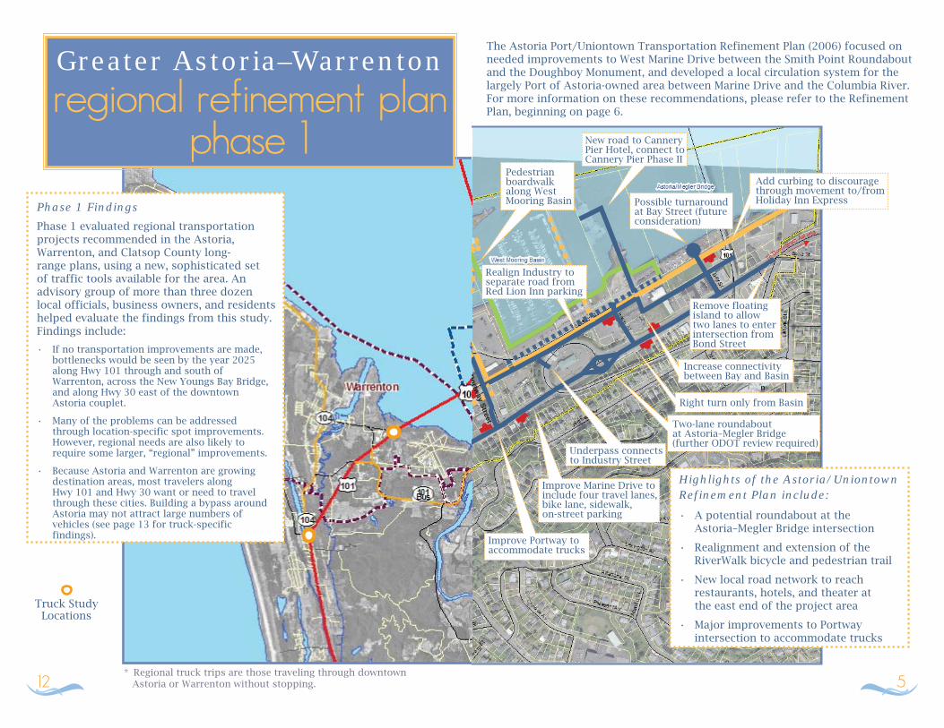
Greater Astoria–Warrentonregional refinement plan
phase 1Phase 1 FindingsPhase 1 evaluated regional transportation projects recommended in the Astoria, Warrenton, and Clatsop County long-range plans, using a new, sophisticated set of traffic tools available for the area. An advisory group of more than three dozen local officials, business owners, and residents helped evaluate the findings from this study. Findings include:
• If no transportation improvements are made, bottlenecks would be seen by the year 2025 along Hwy 101 through and south of Warrenton, across the New Youngs Bay Bridge, and along Hwy 30 east of the downtown Astoria couplet.
• Many of the problems can be addressed through location-specific spot improvements. However, regional needs are also likely to require some larger, “regional” improvements.
• Because Astoria and Warrenton are growing destination areas, most travelers along Hwy 101 and Hwy 30 want or need to travel through these cities. Building a bypass around Astoria may not attract large numbers of vehicles (see page 13 for truck-specific findings).
* Regional truck trips are those traveling through downtown Astoria or Warrenton without stopping.
Truck Study Locations
12
The Astoria Port/Uniontown Transportation Refinement Plan (2006) focused on needed improvements to West Marine Drive between the Smith Point Roundabout and the Doughboy Monument, and developed a local circulation system for the largely Port of Astoria-owned area between Marine Drive and the Columbia River. For more information on these recommendations, please refer to the Refinement Plan, beginning on page 6.
Highlights of the Astoria/UniontownRefinement Plan include:• A potential roundabout at the Astoria–Megler Bridge intersection
• Realignment and extension of the RiverWalk bicycle and pedestrian trail
• New local road network to reach restaurants, hotels, and theater at the east end of the project area
• Major improvements to Portway intersection to accommodate trucks
Portway Street
n
Add curbing to discouragethrough movement to/from Holiday Inn ExpressPossible turnaround
at Bay Street (future consideration)
Remove floating island to allow two lanes to enter intersection from Bond Street
Increase connectivity between Bay and Basin
Right turn only from Basin
Two-lane roundaboutat Astoria–Megler Bridge(further ODOT review required)
Underpass connects to Industry Street
Realign Industry to separate road from Red Lion Inn parking
New road to Cannery Pier Hotel, connect to Cannery Pier Phase II
Improve Marine Drive to include four travel lanes, bike lane, sidewalk,on-street parking
Improve Portway to accommodate trucks
Pedestrian boardwalkalong WestMooring Basin
5

Gatewaymaster plan
The Gateway Area Transportation and Growth Management Plan (1999) recommended circulation and safety improvements along Marine Drive between 16th Street and 33rd Street. Recommendations are described in Appendix G of the Plan.
or
Turn Lane
Parking
Widen orBuild Sidewalk
CurbExtensions
Road Improvements
Pedestrian Safety Issues
Signalization
Realign 23rd to signalized T intersection with Marine (preferred option)
Alternate options:• Signalize; loop Exchange Street into Marine and 23rd T intersection
• Rotary option connected to Exchange/Marine/23rd
• Parking on Marine between 23rd and 29th
• Curb extension on Marine between 27th and 29th
• Eastbound turn lane at 30th/Marine
• Improve existing 30th signal for eastbound left turns
Parallel roadway northof US 30 between36th and 39th
Signalizationof Marine at16th or 17th
Extend one-way couplet at Duaneand Exchange to 17th
Realign Commercial and Marine intersection
Gat
eway
Mas
ter
Pla
n
East
Gat
eway
Tra
nsp
ort
atio
n P
lan
or
or
Center medianson Marinebetween 18thand 20th
Several options considered at 32nd and Franklin. Council has subsequently recommended:• Signal at 33rd/Marine
• Convert Franklin to one-way southeast to 33rd
RiverWalk
New east-west street and alley along RiverWalk between 29th and 32nd
6
The Astoria Transportation System Plan (TSP), completed in 1999, recommends a variety of transportation improvements and provides overall direction for transportation systems in the Astoria urban area over a 20-year timeframe. These improvements are described in Chapter 7 of the TSP.
TSP projects that have been changed through the Downtown Couplet Study (8th and Commercial) and the Greater Astoria–Warrenton Regional Refinement Plan are not shown here. Please refer to the other studies for information about these concepts. Astoria is planning an update to its TSP in the near future.
Marine
Reconstruct intersection
Realign and stripe to serve trucks
Channelization, signing, striping
Channelization, restriping, no parking
Construct left-turn laneProvide turning
refuges, potentially close one or more intersections
Add sidewalks along US 30where not present
Bike lane along OR 202 from Smith Point to Walluski Road
11

Astoriatransportation system plan
Turn lanes and signal
Construct transportation center
Pedestrian island, one-way southbound Marine to Bond
Pedestrian refugeislands at 17thand 20th,center left turn16th to 23rd
Widen tofive lanesbetween 16thand 17th
No parking at 16th and Irving
Repaint bridge
Curb extensions
Repaint Astoria–Megler Bridge, provide demand-response transit service to Washington
Sidewalks, bus shelters, and information kiosks
Bus shelters and information kiosks at bridge approaches
Resurface runway at Astoria Airport
Left turn lane and access control from Columbia to Hume
Left turn refuge and deceleration lane
Rechannel approaches
Center left-turn lane, right-turn deceleration lane
Combine approachesat 2nd/Kearney, add left-turn lane on OR 202
Realign 7th to 5th, create T intersection with Business 101
Transportation Improvements
Bus Shelter
or
Sidewalks along Grand and Lexington
10
East Gatewaytransportation plan
The East Gateway Transportation Plan, completed in 2005, identifies short- and long-term transportation improvements for the sectionof US 30 between 33rd Street and Tongue Point. Please refer to pages 6–12 of the Plan for more information.
Realign US 30 at South Tongue Point; add left-turn pocket
Right turn in only at US 30 and Old US 30
Extend P&W rail service to Tongue Point
Extend Commercial to new Franklin Street bridge project connection
Extend bike lane markings where possible on US 30 from 33rd to 47th
Alignment, channelization, signing, striping improvements atUS 30 and 54th
Three alignments to extending the RiverWalk Trail were considered.
Eastbound left-turn storage lane, signage, narrowing of US 30 travel lanes, roadway illumination, bike lanes at US 30 and 45th
Widen roadway to City standards
7

West Astoria Coupletdevelopmentimprovements
Concept 4: Reconfiguration of 8th andCommercial Street intersection
Concept 3: Extending from5th to 8th Street
Note: drawing is turned 90° counterclockwise
7th
8th
9th
Marine
Commercial
Bond
Mar
ine
Com
mer
cial
Bond
Ast
or
7th
8th
5th
6th
Duane
Commercial
8th
9th
Concept 1:West endof Marine/Duane complex
Note: Concept 5 was No Build.8
The Astoria downtown couplet study explored ideas to improve congestion and safety along US 30 at the intersection of 8th Street and Commercial Street—an area considered unsafe for vehicles, pedestrians, and bicyclists because of high traffic volumes, unclear directional movements, and insufficient room for large vehicles to turn eastbound onto Commercial Street. Five concepts were identified to be refined as part of the Regional Refinement Plan, Phase 2 (see pages 14 and 15). More information on these concepts is provided starting on page 15 of the Couplet Study Plan.
Concept 2: Decouple Marine and CommercialMarine Drive as five-lane, two-directional road
Concept 1: East end ofMarine/Duane complex
Astor
Marine
7th
8th
9th
Marine
Exchange
15th
16th
17th
Duane
Commercial
9