use of gis for enhancing property tax …. vasantha rao bmrc.pdfua vasanth rao general manager...
TRANSCRIPT

UA Vasanth Rao General Manager Finance Taxation & Resources Bangalore Metro Rail Corporation Bangalore
USE OF GIS FOR ENHANCING PROPERTY
TAX REVENUE
AMDA - National Workshop - Property Tax
Surat 7th August 2014
Some Conceptual clarity
Globally properties have been assessed to tax with great accuracy
for over hundreds years without using modern technology and long
before computers were invented.
Property Tax administrators must keep this in mind when deciding
upscaling from manual recall of information to computerization.
IT is not a substitution for assessment but only complements the
effort
IT does not produce administrative skills-
Greater spending on IT will not necessarily produce better results

Conceptual clarity Cont.
•However, a well-planned use of IT will reduce costs, increase accuracy and
consistency of the data, and will certainly save time.
•Helps in analyzing large database in several different formats and detect non-
compliance.
•India Is most suitable for developing IT Based property tax administration as
we have large IT engineers and even larger number of data operators.
•Several Municipalities have begun the process of computerizing property tax
(the successes and the failures) an one can learn from their experience.
•Remember it is important to get the strategy right.
Geographic Information System (GIS) Why GIS for Property Tax ?
Efficiently administer property tax system
Provides a standard toolbox for Tax Officers, Assessors, and Bill Collectors – ensuring
uniformity across jurisdiction
Access to property assessment and tax information in a timely, accurate, and cost
effective manner
Expandable to accommodate future changes in valuation.
Long Terms Goals for GIS
Urban planning using digital data
Identifying and categorizing urban land use
Deriving property size and building density
Planning road maintenance based on width and condition
Determining the slope of the terrain for storm water drains.

Scope of GIS project for Property tax system
To identify all properties in the BBMP area.
To Assign Unique Property Identification Number (PID)
to every property with their details in the BBMP Jurisdiction.
Properties that are in the Tax net are corrected to have an accurate information (on its Site Dimensions, Built up area, Land Use and classification whether Owner occupied or Tenanted) to maximise the tax base.
Prepare GIS framework for integrated and interconnected platform for all other services such as with Trade licenses, Grievances Redressal , Automated building Plan approval , Project Mgmt etc..

BBMP GIS PROCESS FOLLOWED.
The GIS project was initiated to identify all properties that exists in the BBMP
jurisdiction and bring them to the TAX Net with reference to:
The number of properties.
The approximate dimensions of the property.
The usage of the property.
The process followed was to create a base map using satellite image and create a
vector map (direction with coordinates)
The vector map was used to conduct a field survey to correct and gather
information about the properties.
The corrected base map thus created was marked with the help centre
boundaries and provided to the respective tax inspectors.
This helped the TAX inspectors to understand the number of properties and
update the status of tax payment.

BBMP GIS PROCESS FOLLOWED - Contd.,
2009-10
The base map along with the associated register was used to update the tax paid application
number. These updated register was used to update the GIS system to understand the tax
paid status.
Additionally corrections were made to the base map to validate the base map information as
per the field information by the revenue dept.
These corrections were incorporated into the base map.
2010-11
Further survey was done to validate the information in the GIS system and also collect
information pertaining to every property with regards to Assessment of properties.
2011-12
To create a uniform numbering system for the entire BBMP area by issuing a unique property
identification number (PID) in a systematic manner.
Assigning a unique street ID for every street within the BBMP zones.
Assigning a unique property number within each street.
Combine the ward number, street number and property number to assign a PID.

Zoom


ENLARGED IMAGE


Property Verification Schedule Field Operator: Verified by: Date:
Area: Road Name: Map sheet:
Sl.No as per map
Plot/Bldg No. in the
field
Approximate
dimension
Building type
No. of
Floors
Actual land use
Vacant Resi Comm. Temple/Church/Mosque
Govt office School Choultry Utility
1
2
3
4
5
6
7
8
9
10
11
12
13
14
15
16
17
18
19
20
21

GIS Identification of Properties
Use the base map data to generate new maps and updating of system.
Maps plotted as per help centres to the necessary resolution for easy identification.
Maps will contain GIS Number along with identified plot numbers and select landmarks.
The plotted maps along with a legend sheet to collect the following information will be submitted to respective help centres
Identification Sheet Master:
Gather Information and Mark Properties whose Taxes are Paid
Gather Information on Properties whose ownership information is available
Resurvey properties whose identity is not verified and collect data.
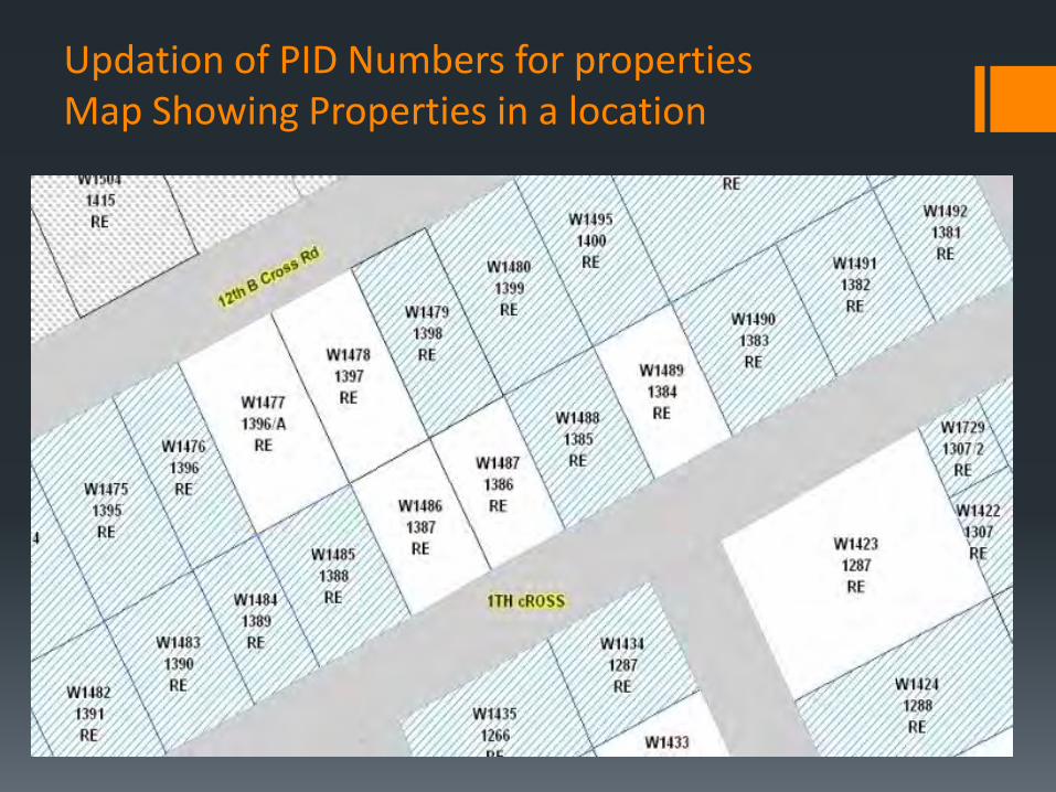
Updation of PID Numbers for properties Map Showing Properties in a location

Assigning PID to Properties
All Properties need to be assigned a Unique Property Identification (PID).
PID number is a combination of
Ward Number + street number + Plot no.
032-W024-256
Streets:
Identify all streets within a Ward Boundary.
Number the streets from West to East and Assign even numbers.
Number the streets from North to south and assign Odd Numbers.
Properties:
Assign Property numbers from north to South or West to East
Assign Even Numbers to Properties on the left
Assign Odd Numbers to properties on Right.

Updation of Properties
Update data as Tax Paid and Tax not Paid.
Additionally information on Properties that have been Assessed and properties that have not been assessed is also available.
The Data availed and updated is used to generate the maps for the GIS Application

Integration with Tax System
The GIS System links to the Taxation System and can display property tax along with ownership information for a particular property.
Property tax returns forms designed by BBMP. Hence helps integration

iPDF Application
The system has scanned images of individual SAS forms.
The scanned images are then processed and data entry has been done. Tax paid has been imported from the Tax net application and a data base has been created for the scanned application.
Security for the data as well as users has been a key component in developing the system. The PDF files are encrypted and the application decrypts the data for viewing and printing.

iPDF Viewer

iPDF Features Scanned images of all Tax paid application
Search functions using the following.
Application Number,
PID,
Owner Name
Property Number
Street
Stage
Locality
Built up area
Site dimensions
Number of floors
Land Use
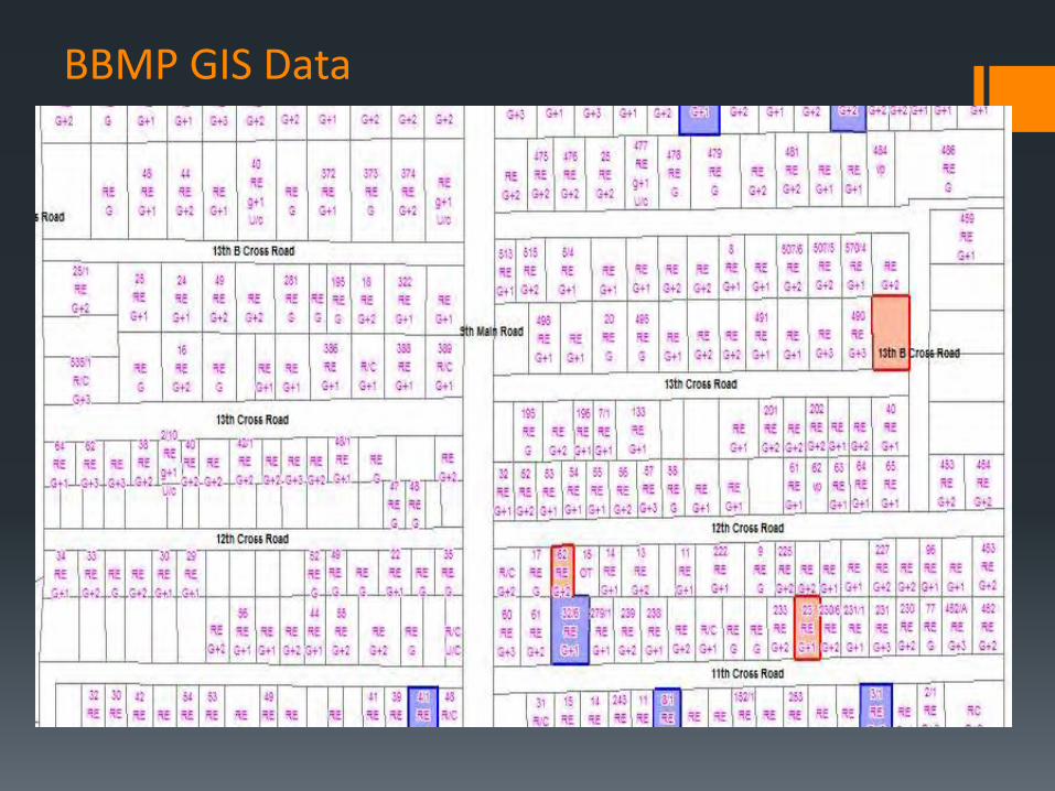
BBMP GIS Data
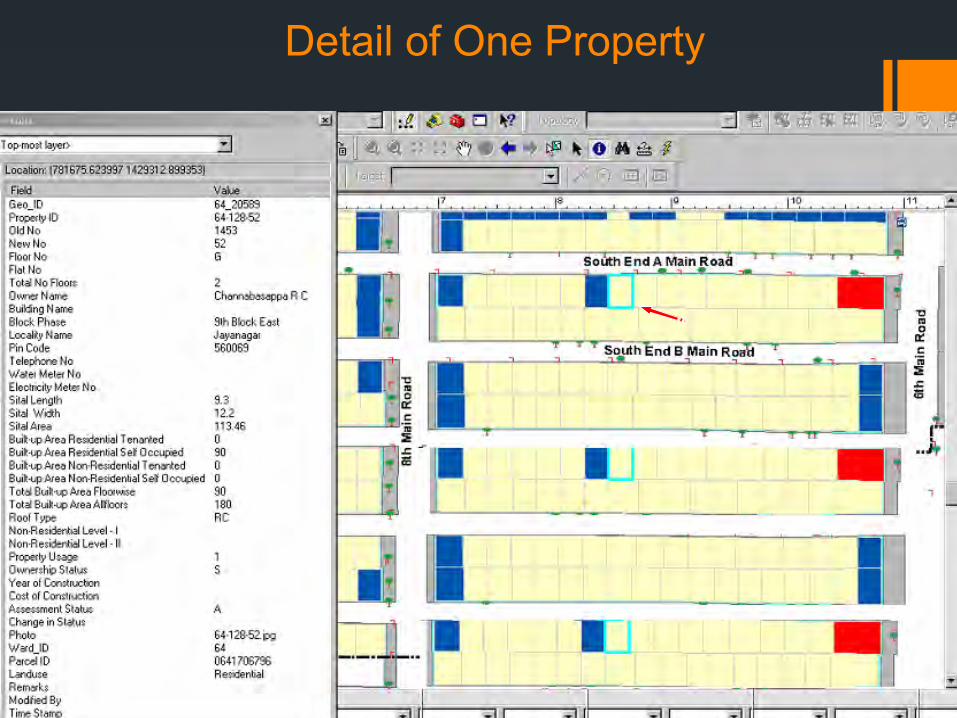
Detail of One Property

Property Summary Ward 99

Residential Buildings
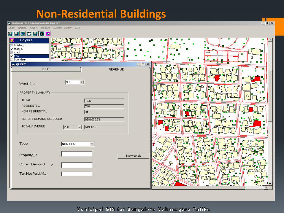
Non-Residential Buildings

Current Demand > Rs 10,000

Property Tax Paid
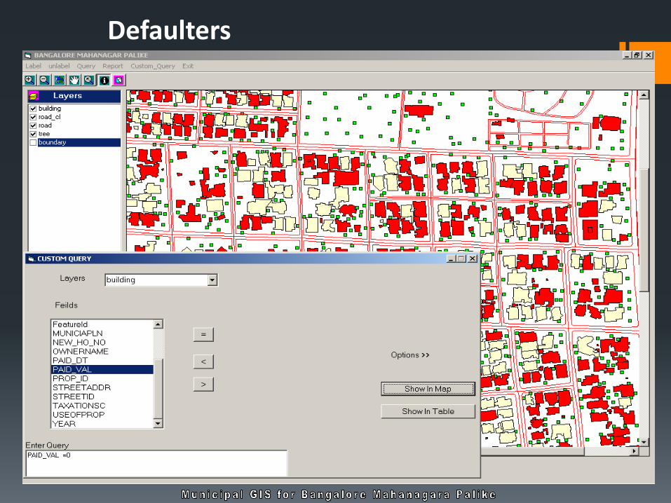
Defaulters

Cont…

All tax, account, and parcel information is available within the same application – no redundancy or duplicate data entry
Accessible anywhere, anytime via the Internet
Photos, documents, and forms can be easily integrated with property records
A history of all transactions will be maintained
Contains integrated statistical and spatial analysis tools
Flexibility with adhoc reporting
Benefits to the Users

Citizen Services
Permits Inspections Historical Bldgs
Billing and collection
Voter Registration Senior Citizen Resident welfare Assn. BSUP Education
Building
license Basic Land Data
Property Tax
Solid waste management system Tracking
Trade license
Birth & Death Immunization programs Hospital
Integrated GIS System
Land Records Tax Mapping Utility Mgmt.
•Owner
•Address
•Land usage/zoning
•Sales
•Property Value
Engineering & Horticulture
SWM, Roads Footpaths, parks
Impact of these process resulted in numbers…..

Number of properties as per GIS
Zone No of Properties
YELAHANKA 148319
MAHADEVAPURA 243169
DASARAHALLI 77892
R R NAGAR 213501
BOMMANAHALLI 224284
SOUTH 243642
WEST 215850
EAST 252714
Total 1619371

Property Tax collections growth (without any increase in the tax rate from 2008 till date )
Financial year Amount in crores
2008-09 625.6
2009-10 566.01
2010-11 1029.25
2011-12 1209.84
2012-13 1350.00
2013-14 1340.00
2014-15 1012.00 ( from Apr 1,2014 to June 28, 2014)

Some of the issues encountered…….
• Lack of motivation and commitment in the field staff
• The absence of effective monitoring system
• Lack of skill set in the staff
• Frequent changes in the staff deployed in field
operations
• The staff has been assigned with other assignments
diluting the intensity required
• Has to operate within the constraints of limited
resources

THANK YOU