use of drone technology in ocean research of the …...tiny circuits arduino gps data logger...
TRANSCRIPT

Use of Drone Technology in Ocean Research of the Saco
River Estuary Supporting Student Research
Michael Esty Lauren Hayden

Gulf of Maine
NOAA https://www.nefsc.noaa.gov/ecosys/
State of the Gulf of Maine Report:Marine Invasive Species June 2010


MakerspaceUniversity of New England
• Project based• Student centered• Career Intelligence
Customers
Classes and Class projectsMakerspace Club Students ResearchInnovation Research
• Science:• Ocean• Environmental• Citizen
• Technology innovation:• Drone• Spatial-temporal• Open source

Training
Multidisciplinary groups
AgilePrototype development
Complete Project
Hardware, Software, Analysis, Presentation
Soldering, 3D printer, Laser cutter, Arduino, Raspberry Pi,Python and ArcGIS

All translates into Spatial Information and Analysis!
Students are trained to bring spatial technology and science into practice!
CAS Undergraduate Research
Spring and Fall Symposiums
Summer Undergraduate Research Experience (SURE)

Technology InnovationROVs, Bouys and Drifters
At the Makerspace we have built several ROVS,Drifters and Underwater buoys.
Matthew Scheuer (Marine Science, ’16) Innovation challenge winner started an ROV company
Electrona is a Somerville-based startup focused on developing low-cost underwater drones. Our remote submersibles allow anybody to shoot HD video, collect scientific data, and recover objects beneath 300 feet of cold, dark water.
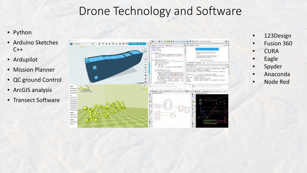
Drone Technology and Software• Python
• Arduino Sketches C++
• Ardupilot• Mission Planner
• QC ground Control• ArcGIS analysis• Transect Software
• 123Design• Fusion 360• CURA• Eagle• Spyder• Anaconda• Node Red

Technology Innovation: DronesPhytoplankton CollectionCarcinus maenas research
Flysky FS-i6X 2.4GHz RC Transmitter TX iA6B Receiver 12 Volt 10 Ah LiFePO4 Lithium Battery 30A ESC T100 Thruster Brushless motors
Future ? Semiautonomous Raspberry piUblox NEO-M8N GPS Module Built-in HMC5883L CompassLoRa Radio Adafruit feather wing

Technology Innovation and Design

Science and EducationUsing a ROV in Student Undergraduate Research
Using ROV in Student U
• Building a Blue Robotics ROV• Hardware and Software debugging• Use in research
• Training new students
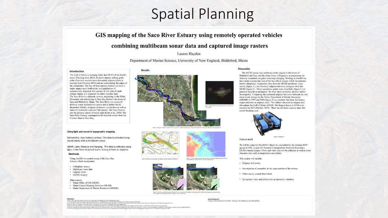
Spatial Planning

Spatial Research

Collecting scientific/spatial data using drifters
Drifter ConstructionTiny circuits ArduinoGPS Data logger
Improvements 555 timer Cree LED
Drone Xenon Strobe Flash Light
LoRa Radio with mapping app
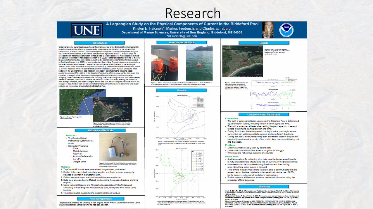
Research

Drifter's spatio-temporal data using ArcGIS
Long Distance Drifter analysis
Longitude and Latitude data CSVPython Haversine formulato get distance and angle each point
Read into excel
Read excel into ArcGIS
Change symbiology to shade by date
Add different online maps for analysis Meteorological, Sea surface temperature and wind.

Future Mapping and multispectral analysis of coral reefs
GPS GO ProSurf BoardDrone 2 mapMultispectral light sourceDirection indicator

Acknowledgements
Anthony Santella M.A., B.A. Stephan I. Zeeman Ph.D.Jeri L. Fox Ph.D. Markus Frederich Ph.D.Charles Tilburg Ph.D.Marcia Moreno-Baez Ph.D.
Lauren HaydenKristen FalcinelliAriella DanzigerAllison TruttlingMatthew Scheuer Brenton MurphyKris OlsonJess StumperSam Peterson