u.s. army corps of engineers spring valley - … remedial...spring valley - baltimore district final...
TRANSCRIPT

U.S. ARMY CORPS OF ENGINEERS
Spring ValleyProperty # C03DC0918
TJ10962
SPRING VALLEY - BALTIMORE DISTRICT
Final Remedial Investigation Evaluation Report
To:Date: January 8, 1998
Project(s): C03DC091801 (Spring Valley - MMRP)Operable Unit(s):Administrative Record(s):Page(s):
From: Contractor, Parsons Engineering Science, Inc.N/A
01, 02, 03, 04, 0501, 02, 03
200
200.1eC03DC091801_03.10_0064

FINALREMEDIAL INVESTIGATION EVALUATION REPORT, OPERATION
SAFE REMOVAL FORMERLY USED DEFENSE SITEWASHINGTON, D.C.
PREPARED BY:
U.S. ARMY ENGINEERING ANDSUPPORT CENTER, HUNTSVILLE,
U.S. ARMY CORPS OF ENGINEERS,BALTIMORE DISTRICT;
AND
PARSONS ENGINEERING SCIENCE, INC.
JANUARY 8,1998
* T J f) 1 n| o '""

FINAL
TABLE OF CONTENTS
PAGE
ACRONYM LIST iv
SECTION 1 EXECUTIVE SUMMARY 1-11.1 Introduction 1-11.2 DCRA Issues Response Summary - 1-21.3 Potential Residual Hazards 1-41.4 Conclusions 1-7
SECTION 2 INTRODUCTION 2-12.1 Report Description And Objectives 2-12.2 Description of DCRA Issues 2-12.3 Objective of the OSR FUDS RI 2-22.4 Report Organization 2-3
SECTION 3 REGULATORY FRAMEWORK 3-13.1 Range Rule Applicability 3-13.2 Regulatory Framework 3-33.3 Timing of OSR FUDS Investigation 3-9
SECTION 4 HISTORICAL FRAMEWORK 4-14.1 Scale and Nature of Operations 4-14.2 Disposal Procedures 4-8
SECTION 5 INVESTIGATION FOUNDATION 5-15.1 Environmental Sampling Foundation 5-15.2 UXO Investigation Foundation 5-3
SECTION 6 POI IDENTIFICATION AND SELECTION PROCESS 6-16.1 POI Selection Rationale 6-16.2 Old Mustard Field 6-76.3 POI Selection Based on Historical Record 6-86.4 POI Placement 6-13
SECTION 7 UXO INVESTIGATION/REMOVAL PROGRAM 7-17.1 Munition Find 7-17.2 UXO Issues 7-27.3 Technology Selection and Rationale 7-47.4 Mission Experience 7-67.5 Anomaly Review Process 7-7
'"• G:\SHAREDtt3177I\FINALRPT\EB7336Rl.DOC

FINAL
TABLE OF CONTENTS(Continued)
PAGE
SECTION 8 ENVIRONMENTAL SAMPLING PROGRAM .T..:8-l8.1 Environmental Sampling Completeness 8-18.2 Mission Experience 8-38.3 Soil Sampling Depth 8-48.4 Sample Location (POI) Rationale 8-58.5 Contaminant Selection 8-98.6 Sample Media Selection 8-138.7 Sample Analysis Procedures 8;168.8 POI 24 8-18
SECTION 9 RISK ASSESSMENT PROCESS 9-19.1 Health Survey 9-19.2 Vapor Exposure '. 9-39.3 Background Level Assessment 9-59.4 Risk Assessment 9-6
SECTION 10 OTHER REPORTS 10-110.1 Comparison to World War I Battlefield 10-110.2 Apex Environmental 10-310.3 Naval Security Station 10-610.4 USEPA Split Data 10-810.5 Lewisite Residue 10-13
SECTION 11 AGENCIES & RESPONSIBILITIES 11-111.1 Review Process 11-111.2 Public Involvement 11-211.3 Emergency Response Procedures 11-4
SECTION 12 CONCLUSIONS 12-112.1 Overall 12-112.2 Regulatory Framework 12-312.3 Historical Framework 12-412.4 Investigation Hypothesis 12-412.5 POI Identification and Selection Process 12-412.6 UXO Investigation/Removal Program 12-412.7 Environmental Sampling Program 12-512.8 Risk Assessment Process „ 12-612.9 Other Reports 12-612.10 Agencies and Responsibilities and Public Involvement 12-712.11 Potential Residual Hazards 12-812.12 Conclusions 12-11
SECTION 13 REFERENCES 13-1
•"•• G:\SHARED\731771\FINALRPT\EB7336RI.DOC

FINAL
TABLE OF CONTENTS(Continued)
PAGE
LIST OF TABLES
Table 6.1 OSR FUDS POI Summary 6-4
Table 6.2 Comparison of Predicted Depth to 1918 Ground Surface withOSR FUDS Soil Sample Depths 6-15
Table 7.1 Summary Of Intrusive And Nonintrusive Anomaly Investigations
OSR FUDS RI 7-12
Table 8.1 Chemicals of Concern By Point Of Interest 8;10
Table 10.1 Comparison of USEPA and USACE Metals Data OSR FUDS RI 10-10
LIST OF FIGURES
Figure 2.1 Point of Interest OSR FUDS 2-5
Figure 3.1 CERCLA Process OSR FUDS RI 3-4
Figure 6.1 Point Of Interest OSR FUDS 6-3
Figure 8.1 POI 24 Locations 8-19
LIST OF APPENDICES
Appendix A DCRA Comment Response and USACE Response IndexAppendix B OSR FUDS Record of Decision and OU-2 Approval LetterAppendix C Cited Location Cross ReferenceAppendix D Corps' Public Involvement/Community Relations Initiative for Operation Safe
Removal, Notice to Residents Letter, and Notification Flow Chart
P:\FUDS\PROJECTS\DC09180 l\RPT4.doc 111

FINAL
ACRONYM LIST
ABP Agent Breakdown Products
AEC Army Environmental Center
ANOVA Analysis of Variance
ARARs Applicable or Relevant and Appropriate Regulations
ARB Anomaly Review Board
ATSDR Agency for Toxic Substances and Disease Registry
AU American University
AUES American University Experiment Station
CEHNC Huntsville Division, USACE
CENAB Baltimore District, USACE
CDC Centers for Disease Control
CERCLA Comprehensive Environmental Response, Compensation, and Liability Act
CFR Code of Federal Regulation
CV Coefficient of Variation
CWM Chemical Warfare Material
CWS Chemical Warfare Service
DANS Data Acquisition and Navigation System
DCOEP District of Columbia Office of Emergency Preparedness
DCRA District of Columbia Department of Consumer and Regulatory Affairs
DERP Defense Environmental Restoration Program
DoD Department of Defense
DQO Data Quality Objectives
EE/CA Engineering Evaluation/Cost Analysis
EM Electromagnetic
EMS Environmental Management Systems, Inc.
EPIC Environmental Photographic Interpretation Center
ERDEC Edgewood Research, Development, and Engineering Center
ESI Expanded Site Investigation
FDES Findings and Determination of Eligibility Study
FS Feasibility Study
FSP Field Sampling Plan
FUDS Formerly Used Defense Sites
GC/MS Gas Chromatograph/Mass Spectrometer '
GIS Geographic Information System
GPR Ground Penetrating Radar
-"K:\SHAREDV731771 \FINALRPT\SB7197JC.ACR IV

FINAL
ACRONYM LIST(Continued)
HD Distilled MustardINPR Inventory Project ReportL LewisiteMDRD Minimum Detectable Relative DifferenceMRI Midwest Research InstituteNTCRA Non-time Critical removal ActionOE Ordnance and ExplosivesOEW Ordnance and Explosive WasteOSR Operation Safe RemovalOSR FUDS Operation Safe Removal Formerly Used Defense SiteOSWER Office of Solid Waste and Emergency ResponseOU Operational UnitPA Preliminary AssessmentPAHs Polynuclear Aromatic HydrocarbonsParsons ES Parsons Engineering Science, Inc.PCB PolychlorinatedbiphenylPIRP Public Involvement and Response PlanPOI Point of InterestQA Quality AssuranceQA/QC Quality Assurance/Quality ControlQAPjP Quality Assurance Project PlanQC Quality ControlRAGS Risk Assessment Guidance for Superfund Human Health Evaluation ManualRBCs Risk-Based ConcentrationsRCRA Resource Conservation and Recovery ActRI Remedial InvestigationROD Record of DecisionROE Right-of-EntryRTAP Real-Time Analytical PlatformSHERP Safety, Health, and Emergency Response PlanSVOCs Semivolatile Organic CompoundsSVRO Spring Valley Resident OfficeTAL Target Analyte ListTCL Target Compound ListTEC Topographic Engineering Center
-K:\SHARED\73177I\FINALRPT\SB7197JCACR

FINAL
ACRONYM LIST(Continued)
TEU Technical Escort Unit
TICs Tentatively Identified Compounds
USACE US Army Corps of Engineers
USACE-TEC US Army Corps of Engineers, Topographic Engineering Center
USATHAMA US Army Toxic and Hazardous Materials Agency (now AEC)
USEPA United States Environmental Protection Agency
UXO Unexploded Ordnance
VOCs Volatile Organic Compounds
WWI World War 1
.K:\SHARED\73I77I\FINALRPT\SB7I97JCACR vi

Section 1

FINAL
SECTION 1
EXECUTIVE SUMMARY
1.1 INTRODUCTION
1.1.1 The Government of the District of Columbia Department of Consumer and
Regulatory Affairs (DCRA) issued a report entitled Final Report on World War I Poison Gas
Production at the American University Experiment Station (the DCRA report) (July, 1996) that
concluded the remedial investigation (RI) and remedial action performed by the US Army Corps
of Engineers (USACE) at the Operation Safe Removal Formerly Used Defense Site (OSR
FUDS) was not adequately completed and that substantial additional action is required to protect
the health and safety of the residents of the Spring Valley area. In addition, DCRA's 30 January
1997 letter (DCRA, 1997) that transmitted the DCRA Report to United States Environmental
Protection Agency (USEPA) addressed additional items of concern at the OSR FUDS.
1.1.2 The OSR FUDS investigation was properly conducted in accordance with the
Defense Environmental Restoration Program (DERP), 10 U.S.C. Sec. 2701-2707 and Section
104 of Comprehensive Environmental Response, Compensation, and Liability Act (CERCLA).
It focused on those areas with the highest probability for imminent health or safety hazards or
environmental contamination. The investigation found no imminent health or safety hazards or
environmental contamination associated with:
1. American University Experiment Station (AUES) ordnance testing;
2. chemical warfare material (CWM), CWM unique breakdown products, or laboratory
contaminants associated with CWM research and development at AUES; or
3. subsequent Department of Defense (DoD) activities at the OSR FUDS.
The Remedial Investigation Report, Site Closure Plan, and Record of Decision were
reviewed and approved by the public and appropriate government agencies. The Record of
Decision was signed June 2,1995.
1.1.3 The following Investigation Evaluation Report provides the comprehensive
USACE response to the DCRA Report and Letter and objectively evaluates and responds to the
issues raised in these documents. Wherever possible, citations to documents previously
K:\SHARED\73177I\FINALRPT\EB7336R1.DOC 1-1

FINAL
prepared for Operation Safe Removal are provided in support of the responses to DCRA's items
of concern.
1.1.4 The DCRA Report (DCRA, 1996) and Letter (DCRA, 1997) contained over 50
separate statements/issues. These issues were evaluated and grouped into nine major topical
areas, as follows:
• Regulatory Framework for the OSR FUDS Investigation and Remediation;
• Historical Framework for the OSR FUDS Investigation and Remediation;
• Investigation Foundation;
• Point of Interest Identification and Selection Process;
• Unexploded Ordnance Investigation/Removal Program;
• Environmental Sampling Program;
• Risk Assessment Process;
• Other Reports; and
• Agencies and Responsibilities.
Each major topic is addressed in a separate section in this report.
1.2 DCRA ISSUES RESPONSE SUMMARY
1.2.1 Regulatory Authority
1.2.1.1 The investigation of the OSR FUDS Site was conducted in accordance with
Defense Environmental Restoration Program (DERP), 10 U.S.C. Sec. 2701-2707 and Section
104 of Comprehensive Environmental Response, Compensation, and Liability Act (CERCLA),
42 U.S.C. 9601 et seg. The OSR FUDS investigation was properly conducted within the usual
sequence of events outlined by the CERCLA process described in USEPA Office of Solid Waste
and Emergency Response (OSWER) Directive 9355.3-01 (USEPA, 1988a). The USACE
encouraged public participation in the decision making process throughout the OSR FUDS
investigation through the Public Involvement and Response Plan developed and implemented by
the USACE, Baltimore District (CENAB) public affairs office. All OSR FUDS investigation
documents were reviewed by the appropriate parties.
K:\SHARED\73177I\FINALRPTVEB7336R1.DOC 1-2

FINAL
1.2.2 OSR FUDS Investigation Basis
1.2.2.1 The investigation was designed to locate:
• Caches of buried munitions associated with DoD activities at the OSR FUDS,
focusing on American University Experiment Station (AUES) activities; and
• Residual surficial soil contamination from CWM or CWM unique breakdown
products from static firings or persistence testing of CWM or residual contamination
from laboratory contaminants associated with CWM research and development at
AUES.
1.2.2.2 The scientific basis of the investigation was to investigate those areas of highest
probability of hazards and expand the area of investigation only if hazards were detected in these
high probability areas. These areas, termed Points of Interest (POIs), were identified in the
historical record as associated with CWM research, development, testing and evaluation. If
unexploded ordnance (UXO) or CWM was not located in those areas of documented use, the
likelihood of UXO or CWM in other areas of the OSR FUDS is remote.
1.2.3 OSR FUDS Investigation Results
1.2.3.1 The only munitions cache was the initial find at 52nd Court which was
associated with an identified POI, POI 14. Following the initial find, over 1,900 anomalies
(including pits, trenches, single items) in 518 properties throughout the OSR FUDS were
investigated. All anomalies were evaluated following an established procedure, including an
external Anomaly Review Board (ARB). The members of the ARB included experts in UXO,
UXO detection, and associated UXO health and safety. The purpose of the ARB was to
thoroughly review the data and determine which anomalies required further investigation.
1.2.3.2 Of the 1,900 anomalies, only four UXO single items were found. Two were
suspect "amnesty" rounds (turned in anonymously by local residents). One was found in plain
sight by the side of a road and the other was found near the USACE Spring Valley Resident
Engineer's Office at the Interim Holding Area. The first was considered a suspect CWM
containing munition because it appeared to contain liquid when handled (weight shifted).
However, there were no static firing attachments and CWM was not loaded into ballistically
fired munitions at AUES. Although it was most likely filled with water or other inert liquid it
was sent to Pine Bluff Arsenal, Arkansas, for disposal. The other amnesty round was sent to
Letterkenny Army Depot, Pennsylvania. The third round was an unfuzed mortar shell
K:\SHARED\73I77I\FINALRPT\EB7336RIDOC 1-3

FINAL
uncovered during_the digging of a footer for a basement extension to a house. It was removed
from the area by the 57th EOD Unit at Ft. Belvoir, detonated, and determined from detonation to
be empty. The fourth was a spent Livens projectile partially filled with smoke agent which was
discovered by the OSR FUDS UXO investigation team. It was sent to a RCRA permitted
commercial facility in Sauget, Illinois, for incineration.
1.2.3.3 No CWM or CWM unique breakdown products were detected in over 260
environmental samples. Several naturally occurring metals which could be associated with
CWM, and others which were not associated with CWM, were detected at levels above
background. However, when subjected to a risk assessment performed in accordance with the
USEPA Risk Assessment Guidelines for Superfund (USEPA, 1989a), these findings were
determined to require no further remedial action.
1.2.4 OSR FUDS Investigation Conclusions
1.2.4.1 The Remedial Investigation concluded with the finding of "No Further Action
Required" for the OSR FUDS, excluding OU-2, the Spaulding and Captain Rankin area. The
Record of Decision (ROD), signed June 2, 1995, documents the "No Further Action Required"
for the OSR FUDS excluding OU-2. The "No Further Action Required" for OU-2 presented in
the draft Site Closure Plan and draft ROD has been approved by USEPA Region III. Final close
out of the entire OSR FUDS is pending resolution of the recently raised District of Columbia
concerns which this report addresses.
1.2.4.2 There are no remaining imminent health or safety hazards on the OSR FUDS as
a result of DoD ordnance or CWM activities.
1 3 POTENTIAL RESIDUAL HAZARDS
13.1 Potential Residual Hazards
1.3.1.1 The USACE identified the following potential residual hazards:
1.3.1.2 Single UXO items. The OSR FUDS investigation focused on detecting large
caches of buried munitions. It was expanded to include detection of single UXO items on
properties in the proximity of POIs. However, single UXO items may remain on site.
1.3.1.3 Buried mustard agent which could exist in a polymerized form. During this
1997 RI evaluation, further analysis of circa 1918 photos of AUES concluded 5 gallon
K:\SHARED\73I771\FINALRPTVEB7336R1.DOC 1-4

FINAL
glass or ceramic containers which could have contained mustard agent may have been buried in a
pit near the fenced perimeter of the AUES (See 1.3.1.4). The disposal practice at the time was to
place containers in a pit, break the container, spread chlorinated lime over the mustard agent, and
backfill the ph. Under these conditions, it is possible mustard agent could exist in a polymerized
form.
1.3.1.4 POI24. POI24 was incorrectly located during the RI. As a result of the current
RI evaluation, aerial and supporting photographs were reviewed by the USACE Topographical
Engineering Center (TEC). Based upon this review, the revised POI 24 location is on the
grounds of 4801 CHenbrook Drive instead of the American University property. This review also
identified this location as a possible mustard agent burial pit (see 1.3.1.3).
1.3.2 Potential Risia
1.3.2.1 Undisturbed, these potential hazards pose no risk to the public. Possible single
UXO Hems will not spontaneously detonate. If polymerized mustard exists, it is not releasing
mustard vapors in hs current form. To present a hazard it must contact the skin. However, if
disturbed through digging such as construction activity, these potential hazards may be a risk to
the public as described below:
1.3.2.2 Single UXO items. The probability of the public encountering a single round is
remote. During the RI, over 1,900 anomalies were investigated in 518 properties throughout the
OSR FUDS with only four intact UXO single items found. None of the intact UXO single items
found were hazardous or posed any danger to the public prior to or upon discovery. All were
unfiized. In addition, with the exception of the cache found at the identified POI 14, there have
been minimal UXO items uncovered, even though there has been significant land development in
the OSR FUDS area since 1918.
1.3.2.3 Buried Polymerized Mustard Agent. The probability of the public coming in
contact with buried polymerized mustard agent is also remote. Besides POI 24, a possible burial
pit, polymerized mustard would only be associated with random locations where mustard may
have been spilled and subsequently decontaminated. The polymerized form has the consistency
of asphalt and minimal vapor pressure. If it exists in the polymer form, it is most likely in a
relativdy thin layer (from spilling from the broken containers) and must be disturbed to become a
hazard. This hazard would be a potential contact hazard causing skin bums, but is not an
inhalation hazard. In addition, the hazard would be very localized, affecting only those who came
in direct contact with the agent. It is not a splash or vaporization hazard. Although mustard can
K:T731771\FINALltfT«PAFIN~l\EB7336R3JXX: 1-5

FINAL
mustard can exist in the polymer form for many tens of years, there is an equal probability the
agent completely degraded to much less toxic breakdown products. Of over 160 soil samples
from known mustard agent test areas, none contained mustard agent or mustard-agent
breakdown products. This indicates complete breakdown of the mustard agent.
1.3.2.4 POI 24. The Army is recommending additional investigation to determine if
residual hazards, specifically mustard agent containers or polymerized mustard, exist at this
location.
1.3.3 Additional Investigation
1.3.3.1 Single UXO items. No additional investigation for single item UXO is
warranted. While the technology exists to locate UXO single items, in the Spring Valley urban
environment, the technology does not exist to distinguish a single UXO anomaly from urban
anomalies such as construction debris, ferrous rocks, etc. The OSR FUDS investigation focused
on those areas most likely to contain UXO caches and was expanded to detect single UXO items
within the POIs. Minimal UXO was discovered in these high probability areas. Expanding the
investigation to low probability areas is unlikely to uncover additional UXO single items.
1.3.3.2 Buried Polymerized Mustard Agent. With the exception of POI 24, no other
locations favor the formation of polymerized mustard. Therefore, no additional investigation for
buried polymerized mustard agent is warranted.
1.3.3.3 POI 24. Based upon the additional photo interpretation and the potential for
polymerized mustard to exist at POI 24, the Army recommends further investigation of POI 24.
This includes additional geophysical investigation and soil sampling to determine if polymerized
mustard exists at POI 24.
13.4 Recommendations
1.3.4.1 Perform additional investigation of POI 24 to include additional geophysical
surveying and soil sampling. Develop and implement a public involvement and response plan to
address the issues at POI 2*4.
1.3.4.2 With the possible exception of POI 24 where there is photographic evidence
mustard agent may have been disposed in a pit, the possibility of public contact with single
UXO items or buried polymerized mustard agent is extremely remote and will be associated
with digging activities. To minimize the potential for injury in the event of a chance discovery
of a single UXO item or buried polymerized mustard agent, the existing emergency response
K:\SHARED\731771\FINALRPTyEB7336Rl.DOC 1-6

FINAL
procedures (911). should be reinforced and expanded by local authorities. The Army will
prepare a fact sheet describing the UXO items (e.g., pictures of common AUES rounds) and the
characteristics of buried polymerized mustard agent (e.g., would be found in conjunction- with
ceramic or glass fragments, has a garlic odor) and notification procedures. The fact sheet should
be provided by the D.C. government to:
1.3.4.2.1 Spring Valley OSR FUDS area residents and contractors whenever a digging
permit is issued.
1.3.4.2.2 Emergency response personnel.
1.3.4.2.3 All new Spring Valley OSR FUDS area residents at time of title transfer.
1.3.4.2.4 All Spring Valley OSR FUDS area residents through an annual mailing
1.3.4.2.5 Other citizens as determined appropriate by the DC Government.
1.4 CONCLUSIONS
1.4.1 The OSR FUDS investigation was properly conducted in accordance with
CERCLA and DERP. It focused on those areas with the highest probability for imminent
hazards or environmental contamination. The investigation found no imminent health or safety
hazards or environmental contamination associated with AUES ordnance testing or CWM or
CWM unique breakdown products. The Remedial Investigation Report, Site Closure Plan, and
Record of Decision were reviewed and approved by the public and appropriate government
agencies. The Record of Decision was signed June 2,1995.
1.4.2 POI 24 was incorrectly located during the RI. As a result of the current RI
evaluation, aerial and supporting photographs were reviewed by the TEC. Based upon this
review, the revised POI 24 location is on the grounds of 4801 Glenbrook Drive instead of the
American University property. This photographic review also concluded this location is a
possible mustard agent burial pit (see 1.3.1.3). Although this does not present an imminent
hazard to the public, the Army recommends additional investigation to confirm and mitigate any
potential future hazard. All the other POI locations were reviewed and determined to be
accurately located in the OSR FUDS RI Report and appropriately investigated.
1.4.3 There is a possibility that UXO single items or buried polymerized mustard agent
remain on the site; however, there is no risk to the public if these remain undisturbed. The
K:\SHAREm73l77l\ITOALRFTVEB7336RI.DOC 1-7

FINAL
possibility of public contact with single UXO items or buried polymerized mustard agent is
extremely remote and will be associated with digging activities. Additional investigation to
locate any potentially remaining UXO single items or buried polymerized mustard agent,.with
the exception of POI 24, is not warranted. The risk to the public is remote and the investigation
is not technically feasible.
1.4.4 To minimize the potential for injury in the event of a chance discovery of a single
UXO item or buried polymerized mustard agent, the existing emergency response procedures
should be reinforced and expanded. The Army will prepare a fact sheet describing the UXO
items, the characteristics of buried polymerized mustard agent, and notification procedures.
This information should be provided by the D.C. Government to residents and contractors
whenever a digging permit is issued, to new Spring Valley area residents, annually to Spring
Valley area residents, to emergency response personnel, and to other citizens as determined
appropriate by the DC Government.
1.4.5 Consistent with its obligations under CERCLA and DERP, the Army remains
responsible for any additional response actions necessary in relation to buried munitions and
environmental contamination associated with prior Department of Defense (DoD) activities at
the OSR FUDS.
References:
DCRA, 1996. Final Report on World War 1 Poison Gas Production at the American UniversityExperiment Station. Government of the District of Columbia Department of Consumer andRegulatory Affairs Environmental Regulation Administration, Hazardous Waste Branch.
DCRA, 1997. Letter dated 30 January 1997 from Mr. Hampton Cross (DCRA) to Mr. ThomasVoltaggio (USEPA Region III).
USEPA, 1989a. Risk Assessment Guidance for Superfiind: Volume 1 - Human HealthEvaluation (Part A). Washington, DC: Office of Emergency and Remedial Response.EPA/540/1-89/002.
K:\SHARED\731771\nNALRPT\EB7336Rl.DOC 1-8

Section 2

FINAL
SECTION 2
INTRODUCTION
2.1 REPORT DESCRIPTION AND OBJECTIVES
2.1.1 DCRA issued the DCRA Report (DCRA, 1996) that concluded the RI and remedial
action performed by USACE at the OSR FUDS was not adequately completed and that
substantial additional action is required to protect the health and safety of the residents of the
Spring Valley area. In addition, DCRA's 30 January 1997 letter (DCRA, 1997) that transmitted
the DCRA Report to USEPA addressed additional items of concern at the OSR FUDS.
2.1.2 This Comprehensive Report provides the USACE response to the DCRA Report
(DCRA, 1996) and Letter (DCRA, 1997) and objectively evaluates and responds to the issues
raised in these documents. Wherever possible, citations to documents previously prepared for
Operation Safe Removal are provided in support of the responses to DCRA's items of concern.
2.2 DESCRIPTION OF DCRA ISSUES
2.2.1 The DCRA Report and Letter were reviewed and a matrix of issues was developed
by listing each statement made in the DCRA Report (DCRA, 1996) and Letter (DCRA, 1997)
regarding the efficacy of the OSR FUDS investigation and remediation program and identifying
the issue associated with the statement. Over 50 separate statements/issues were identified in
the DCRA Report (DCRA, 1996) and Letter (DCRA, 1997). The issues were then evaluated and
grouped into nine major topical areas, with each major topic area assigned a section number in
this report, as follows:
3 Regulatory Framework for the OSR FUDS Investigation and Remediation;
4 Historical Framework for the OSR FUDS Investigation and Remediation;
5 Investigation Foundation;
6 Point of Interest Identification and Selection Process;
7 Unexploded Ordnance Investigation/Removal Program;
8 Environmental Sampling Program;
G:\SHAREDV73177 lVFINALRPT\EB7322RP.doc 2-1

FINAL
9 Risk Assessment Process;
10 Other Reports; and
11 Agencies and Responsibilities.
Each DCRA issue was assigned to one of these identified topics. Similar issues within these
broad topic headings were then grouped to minimize redundancies.
2.3 OBJECTIVE OF THE OSR FUDS RI
2.3.1 The objective of the OSR FUDS investigation was to determine if potential
hazards exist in the OSR FUDS area as a result of past DoD activities during World War I. The
OSR FUDS investigation area encompasses the location of two facilities occupied by the DoD
during the World War I period: the former AUES and Camp Leach. AUES was established in
1918 as a "chemical warfare research center" (US ACE, 1994a). The neighboring Camp Leach,
previously named Camp American University, was also established in 1918 to train the 6th
Engineer Regiment (US ACE, 1995b).
2.3.2 The OSR FUDS RI focused on two potential hazards associated with DoD
activities at the site: 1) the potential presence of buried UXO, and 2) potential surficial soil
contamination by CWM, CWM unique breakdown products, or laboratory, or laboratory
contaminants associated with AUES CWM research and development. This was accomplished
by identifying and investigating POIs, which are OSR FUDS locations identified in the historical
record as the areas most likely to be impacted by AUES or Camp Leach activities.
2.3.3 The UXO investigation focused on the detection of pits and trenches potentially
containing caches of UXO. Geophysical surveys were performed at POIs identified in the
historic record as pits or trenches. In addition to these POI surveys, a "spot check" of
approximately ten percent of the properties not located within the boundaries of a POI were also
geophysically surveyed for UXO caches to confirm the hypothesis that potential UXO burial at
the OSR FUDS was limited to POIs (USACE, 1995a).
2.3.4 The investigation of potential surficial soil contamination focused on those POIs
identified in the historical record as having potentially been used for, or impacted by, static test
firing of CWM munitions (remote detonation of a stationary munition), application of CWM to
G:\SHAREDV73177 l\FINALRPT\EB7322RP.doc 2-2

FINAL
the ground surface for persistency testing, and documented accidental releases of hazardous
laboratory compounds. A statistically-based sampling strategy was utilized to select sampling
locations at each POI, and in the case of naturally-occurring compounds, the generated data were
statistically compared to background concentrations.
In addition, soil samples were taken from sidescan boreholes (boreholes adjacent to
suspect UXO items used for sidescan magnetometer access to investigate the anomalies) and in
the areas surrounding UXO removals.
2.4 REPORT ORGANIZATION
2.4.1 This report includes sections for each of the nine major topical areas identified in
the DCRA Report and Letter described above, this introduction, a conclusions section, and a
references section. Each section that addresses identified DCRA issues includes the following:
• DCRA Comments/Issues: direct quotation of comments of a similar theme from the
DCRA Report and Letter are listed in tabular format at the top of each page, and
include page, paragraph, and line number references for the statement/issue in the
DCRA Report;
• Salient Issues - this portion provides the USACE interpretation of the critical
issue(s) raised by the statement(s) quoted in the table;
• Response - this portion provides the USACE response to the salient issues raised by
the quotes from the DCRA Report and Letter listed at the top of the page; and
• Reference - this portion provides document references cited in the response.
In addition to the twelve sections in the main body of the report, this report also includes the
following appendices.
• Appendix A - is a cross reference that lists the DCRA comments in the order
presented in the DCRA Report and Letter and the corresponding location(s) in this
report of the USACE response;
• Appendix B - is a signed copy of the Record of Decision and approval for OU-2;
• Appendix C - is a cross reference of zones, POIs and key locations mentioned in the
text (i.e., initial find, 4801 Glenbrook, AU President's house); and
K:\SHAREDY731771 \FINALRPT\EB7318RP.DOC 2-3

FINAL
• Appendix D - is a copy of the notice submitted to the OSR FUDS residents at the
completion of the project and a USACE flow chart outlining the notification
procedures within the D. C. Government.
Figure 2.1 shows all POIs and locations mentioned in this report.
References:
DCRA, 1996. Final Report on World War I Poison Gas Production at the American UniversityExperiment Station. Government of the District of Columbia Department of Consumer andRegulatory Affairs Environmental Regulation Administration, Hazardous Waste Branch.
DCRA, 1997. Letter dated 30 January 1997 from Mr. Hampton Cross (DCRA) to Mr. ThomasVoltaggio (USEPA Region III).
USACE, 1994a A Brief History of the American University Experiment Station and US. NavyBomb Disposal School, American University. Office of History, Headquarters USACE.
USACE, 1995a. Zone 2 Report, Operation Safe Removal Project, Washington DC February1995. Prepared for US Army Corps of Engineers, Huntsville Division and Baltimore District.Prepared by Parsons Engineering Science, Inc.
,K:\SHAREDV73I771\FINALRPr\EB7318RP.DOC 2-4

Numbwtd Pdnta of kitorwt
1. OretMrTranchai2. PoariWtPIt3. 8mel Crater Scam4. PoMfetoPtt5. PoaMoPK8. PoajfeteTsgtt or Tartar*7. Po—y» Tart Aral
9. PoeribM) Rrhg or Obeefweflon Stall10. POMMO Target or Tart Site11. 8eaMr«d»gundScars
11 OroivTranehai14. PR15. Grand Scar18. Chorrteal Perahtenoy Tart Aral17. PoetttPR18. SmaiCratarScan19. OMMueMRaU20. OroundScar21. SMI Pit22. a m Pit23. ShaiPIt24. ProbebMPIt244t ProbaMa PR. R u l n d L O M I W
28. SnaDCtatorScara27. ProbabtaTranahorDrtoh2B. PfOBCDle) TrQflCft OP UnBI29. OrowMSear30. JwWngTwnohw
32. paWngJrinohai33. TuWnj TTWIQFMS34. TnWflQ TfvnoneM35. TraMngTranerMa38. TraMngTraxhai37. i "38.39. StaleTartRraArsa40. ONotWI41. HMoryBuMng42.
Figure 2.1
Spent Uvens Round
5010 SedgewtekUnfused3*Stokes Mortar
^
43. OuiPIt
47. BactorWogleal Laboratory48. nsparsoMi Laboratory49. Prarmaoctoglcal Laboratorj50. Out Pit51. Rm and Ran* Laboratory52.53. BatarVMay
NeVnvQ PCMU ov knternt
P D M H * U«ar Dapraarion
POI East Creek
POI Baker V
Unfuted Stokes MortarRound Laft by InterimHolding Area
• Point of Interest| | Point of Interest Boundary| ~ | Zone Boundary^ Building
Road/ \ / Camp Leach Boundary^ ^ f Spring Valley Boundary
POIAU
4801 Glenbrook
Unflred 75 rnmProJectHe
4835 GlenbrookAU President's Residence
Thtorr^v«praparadforuMOfthaU.S.AmyCorpaofEr^na»r»torllu»trattvopurpoaaa orty. Tr* map was created uakig data prepared from vattoua eouroat.ItdoeanotrapraeantasuveyofOieslta. The acela. accuracy, and complataneaa of the data la not
. . . "astDlheauBder^orecctwcyofthao^taccnectadrieraon.
PARSONSENGINEERINGSCIENCE, INC.
ApprodmatoSerf*
0 400 800
FMt
POINT OF INTERESTOSRFUDS
OPERATION SAFE REMOVAL
SOURCE:USDA1976
Zone Map
JOB NUMBER: 731771DOCUMENT NO.:DAS SHEET:
US Army Corpsof Engineers

Section 3

FINAL
SECTION 3
REGULATORY FRAMEWORK
3.1 RANGE RULE APPLICABILITY
No.
1
51
57
59
Location in DocumentPP
1
17
2
2
12
3
3
4
Lines
1-6
8-12
1-2
1-5
Statement in Document
".... this urgency did not permit the orderly and usual sequence of operations forremediation of formerly used military sites. The Draft Proposed Military Range Rule(hereinafter. Range Rule), 32 CFR 339 4/15/96 stresses the need to examine the entirerange after a range assessment/accelerated response (RA/AR) is completed.""Our view on the need for a complete site investigation with a study of environmentalcontamination, health impacts, and a search of the entire area for individual UXO andburied stockpiles is also confirmed by the proposed Range Rule."Letter to USEPA from DCRA"Many of the recommended procedures in the DoD's Proposed Range Rule, 32 CFR178, including a Site Specific Response Evaluation, were not completed.Letter to USEPA from DCRAFinally, new technology, such as microgravity analysis, soil gas surveys with colorcontour maps, and Pulsed Fast Neutron (PINS) Analysis are now available. TheProposed Range Rule allows for reopening of a range when new technology would behelpful in clearance activities. Also, a deep seeking magnetometer with a datarecording system and global positioning system (GPS), designed specifically forlocating deep burial areas, could be used."
Salient Issue:
Determine the applicability of the Draft Proposed Military Range Rule to the OSR
FUDS.
Response:
3.1.1 The OSR FUDS investigation was properly conducted under the applicable laws in
effect during the investigation - the Defense Environmental Restoration Program (DERP), 10
U.S.C. Sec. 2701-2707 and Section 104 of the Comprehensive Environmental Response,
Compensation and Liability Act (CERCLA), 42 U.S.C. 9601 et seg. The Draft Military Range
Rule (MRR), recently published in the Federal Register for public comment, was initially
proposed April 15, 1996, while the OSR FUDS RI was being finalized. Until the MRR is
promulgated and becomes an enforceable regulation, it is inappropriate to apply the MRR to the
OSR FUDS investigation, or other current projects, since it is subject to potentially significant
revision prior to finalization. However, the Army is confident the OSR FUDS RI was conducted
within the intent of the MRR as it is currently proposed.
K:\SHAREDV731771\F1NALRPT\EB7318RP.DOC 3-1

FINAL
Reference:
Department of Defense, 1997. Draft Proposed Military Range Rule. Department of Defense.32 CFR 178.
... K:\SHAREDV731771\FINALRPT\EB7318RP.DOC 3-2

FINAL
3.2 REGULATORY FRAMEWORK
No.
1
58
Location in DocumentPP
1
2
H2
3
Lines
1-6
2-3
Statement in Document
".... this urgency did not permit the orderly and usual sequence of operations forremediation of formerly used military sites. The Draft Proposed Military Range Rule(hereinafter, Range Rule), 32 CFR 339 4/15/96 stresses the need to examine the entirerange after a range assessment/accelerated response (RA/AR) is completed."Letter to USEPA from DCRA"Neither a CERCLA Preliminary Assessment nor a RCRA Facility Assessment wascompleted"
Salient Issue:
1) Determine if there was an orderly and usual sequence to the operations associated with
investigation of the OSR FUDS. 2) Determine if a CERCLA Preliminary Assessment or
Resource Conservation and Recovery Act Facility Assessment (RCRA) is applicable to the OSR
FUDS investigations.
Response:
3.2.1 The investigation of the OSR FUDS Site was conducted in accordance with
DERP, 10 U.S.C. Sec. 2701-2707 and Section 104 of CERCLA, 42 U.S.C. 9601 et sea. A
RCRA Facility Assessment was not applicable to the OSR FUDS investigation because RCRA
applies to current hazardous waste facilities. The OSR FUDS is not a current hazardous waste
facility.
3.2.2 The RI process followed during the OSR FUDS investigation was properly
conducted within the usual sequence of events outlined by the CERCLA process described in
USEPA OSWER Directive 9355.3-01 (USEPA, 1988a) as shown in Figure 3.1
3.2.3 After the discovery and removal of the UXO at 52nd Court, the Army performed a
thorough investigation for contamination in accordance with the CERCLA process. The
investigative process at the OSR FUDS followed the standard CERCLA sequence of
preliminary assessment, (expanded) site inspection/remedial investigation, and record of
decision. A feasibility study was not performed because no hazard was identified.
K:\SHARED\731771\FINALRPTVEB7336R I .DOC 3-3

FIGURE 34CERCLA PROCESS
OSR FUDS RI
FINAL
PreliminaryAssessment
USEPAReview
No HazardIdentified
Remedial Investigation
HazardIdentified
Removal ActionTCRA
NTCRA
Public Comment
ROD/Closure Report
All OEW/HTW Removedor
No OEW/HTW Found
USEPAReview

FINAL
3.2.4 A preliminary assessment (PA) was performed, which included: 1) a review of the
historical record; 2) the photointerpretation of 1918 and 1927 aerial photographs relative to
current aerial photographs; 3) the collection of existing site data; 4) the identification of
investigation area boundaries; and 5) a review of potential remedial action objectives. The PA
also included the generation of the Inventory Project Report (INPR) with 2 addendums (See
Section 3.3). A summary of the information generated during the historical review is presented
in A Brief History of the American University Experiment Station and US Navy Bomb Disposal
School, American University (The Historical Summary) (USACE, 1994a). The historical record
report summarized the past uses of the OSR FUDS, reviewed existing information on the site,
preliminarily identified site hazards, and identified the need for remedial action. The historical
documents that were reviewed are located in the national archives. The technical reports used
during the PA are located in the Fisher Library, Ft. McClellan, Alabama, and in the Chemical
and Biological Defense Agency historian's office at the Edgewood Arsenal, Maryland. The five
tasks mentioned above, the INPR with 2 addendums, and the report The Historical Summary
(USACE, 1994a) are the PA, as outlined by the CERCLA process for a preliminary assessment.
3.2.5 Based upon the PA, an Expanded Site Inspection (ESI) was begun. The purpose
of an ESI, as explained by OSWER Directive 9345.1-02 (USEPA, 1988b), is to generate
comprehensive data on the existence, sources and extent of environmental contamination at a
site, and to provide the foundation for the remedial investigation focus. The ESI included
development of:
• Data Quality Objectives (DQOs) (USACE, 1994b);
• Health and Safety Plan (USACE, 1994c). This was a thorough plan to meet the
requirements of the USACE Safety, Health, and Emergency Response Plan (SHERP)
due to the potential for UXO and CWM;
• Quality Assurance Project Plan (QAPjP) (USACE, 1994b). This was a thorough
planning document to meet the DQOs and the requirements to use a laboratory
approved by the Army to handle CWM. Since calibration of the analytical
instruments for CWM requires access to CWM, the Army requires special security
and health and safety procedures. Very few laboratories have this approval.
• Field Sampling Plans: Volumes I and II (FSP) (USACE, 1994d and 1994e). The
FSP was developed to measure those CWM and breakdown products most likely
associated with the activities of the specific POL Refer to Section 8.4.1.2 for a
discussion of the statistical sampling strategy.
IC\SHARED\73I771\FINALRFT\EB7336R1.DOC 3-5

FINAL
During the ESI investigation over 260 soil, surface water and groundwater samples were
collected at nineteen POIs throughout the OSR FUDS. Eleven time critical removal actions
(TCRA) were performed to excavate 74 suspect anomalies. - -
3.2.6 The data collected during Operation Safe Removal supported a "No Further Action
Determination." However, rather than declare "No Further Action Required," the Army
continued through the CERCLA process. A major consideration was the desire for public
participation in the process.
3.2.7 The results of the investigation were subjected to the more rigorous evaluation Of a
RI. This included all appropriate steps required by CERCLA. Specifically, USACE conducted
the field investigation, determined the nature and extent of contamination, identified applicable
or relevant and appropriate requirements (ARARs), and conducted a baseline risk assessment in
accordance with Risk Assessment Guides for Superfund (USEPA, 1989a). The results of the
investigation are presented in Section 6 of the Remedial Investigation Report for the Operation
Safe Removal Formerly Used Defense Site, Washington D.C. (OSR FUDS RI Report) (USACE,
1995b). The OSR FUDS RI was reviewed by USEPA Region III.
3.2.8 A Feasibility Study, which usually accompanies a Remedial Investigation, was not
conducted at OSR FUDS based upon the results of the risk assessment. The ESIXRI
investigation did find a potential hazard in POIs 21 and 23 based on soil debris samples
collected from inside the abandoned bunkers as well as the potential for UXO to be found in the
bunkers. These POIs were initially identified as shell pits. However, they were actually
concrete bunkers used for testing. They were further investigated separately as OU-2. POI22, a
similar bunker structure that is included in the structure of the existing residence (it is the utility
room), was included in OU-2.
3.2.9 Following the Remedial Investigation, USACE followed the CERCLA process
and selected a remedial action based upon the OSR FUDS investigation. The remedial action
selected for OSR FUDS excluding OU-2 was "no further action." USACE prepared a Proposed
Plan for the OSR FUDS which outlined the rationale for the selection of the remedial alternative
and presented a summary of the information generated during the OSR FUDS investigation.
The proposed plan was prepared in accordance with USEPA Guidance on Preparing Superfund
Decision Documents (USEPA, 1989b). Following the Public Comment period, USACE moved
to the final step in the CERCLA remediation process by finalizing the Record of Decision
(ROD) for OSR FUDS, excluding OU-2, documenting the no further action decision. The ROD
is dated June 2,1995 and is included as Appendix B.
K:\SHARED\731771\FINALRFAEB7336R1.DOC 3-6

FINAL
3.2.10 Based on the potential hazard at OU-2 (POIs 21, 22 and 23), an Engineering
Evaluation/Cost Analysis (EE/CA) for a non-time critical removal action (NTCRA) was
performed. The removal action took place between October 11,1994 and January 19, 1995. No
CWM, CWM unique breakdown products, or UXO items were found within POIs 21, 22, or 23.
The results of the EE/CA and NTCRA are summarized in Section 5.3 of the OSR FUDS RI
Report (USACE, 1995b). Following the EE/CA and NTCRA, a RI was performed on OU-2.
Following the RI, USACE followed the CERCLA process and selected a remedial action based
upon the OU-2 investigation. The remedial action selected for OU-2 was "no further action."
USACE prepared a Proposed Plan for the OU-2 which outlined the rationale for the selection of
the remedial alternative and presented a summary of the information generated during the OU-2
investigation. The public comment period is complete and the USEPA Region III has approved
the draft site closure plan and draft record of decision. Final site close out is pending the
resolution of the current DCRA issues.
3.2.11 An orderly and usual sequence of events was performed during the OSR FUDS.
All applicable regulations were followed and the steps taken to perform this investigation were
reviewed and approved by the USEPA.
Reference:
USACE, 1994a A Brief History of the American University Experiment Station and US NavyBomb Disposal School, American University. Office of History, Headquarters USACE. June1994a.
USACE, 1994b. Quality Assurance Project Plan, Spring Valley Operation Safe RemovalProject, Washington, D.C. Prepared for US Army Corps of Engineers, Huntsville Division andBaltimore District. Prepared by Parsons Engineering Science, Inc.
USACE, 1994c. Health and Safety Plan, Spring Valley Operation Safe Removal Project,Washington, D.C. Prepared for US Army Corps of Engineers, Huntsville Division andBaltimore District. Prepared by Parsons Engineering Science, Inc.
USACE, 1994d. Field Sampling Plan for Remedial Investigation, Spring Valley OperationSafe Removal Project, Washington, D.C. Volume I: General Protocols. Prepared for US ArmyCorps of Engineers, Huntsville Division and Baltimore District. Prepared by ParsonsEngineering Science, Inc.
USACE, 1994e. Field Sampling Plan for Remedial Investigation, Spring Valley Operation SafeRemoval Project, Washington, DC Volume II: Site-Specific Plans. Prepared for US ArmyCorps of Engineers, Huntsville Division and Baltimore District. Prepared by ParsonsEngineering Science, Inc.
K:\SHARED\73177I\FINALRPT\EB7336R1.DOC 3-7

FINAL
US ACE, 1995b. Remedial Investigation Report for the Operation Safe Removal FormerlyUsed Defense Site, Washington DC. Prepared for US Army Corps of Engineers, HuntsvilleDivision and Baltimore District. Prepared by Parsons Engineering Science, Inc.
USEPA, 1988a Guidance for Conducting Remedial Investigations and Feasibility Studiesunder CERCLA. OSWER Directive 9355.3-01.
USEPA, 1988b. Expanded Site Inspection Transitional Guidance. OSWER Directive9345.1-02.
USEPA, 1989a. Risk Assessment Guidance for Superfund: Volume I - Human HealthEvaluation (Part A). Washington, DC: Office of Emergency and Remedial Resporlse.EPA/540/1-89/002.
USEPA, 1989b. Guidance on Preparing Superfund Decision Documents: The Proposed Plan,The Record of Decision, Explanation of Significant Differences, The Record of DecisionAmendment, Interim Final (EPA 540-G-89-007).
K:\SHARED\731771\FINALRPT\EB7336R1.DOC 3-8

FINAL
3.3 TIMING OF OSR FUDS INVESTIGATION
No.
4
Location in DocumentPP1
13
Lines
8-14
Statement in Document ~ '
"Although the American University site was identified by the Federal government in1985, stakeholders were not informed until the buried munitions story emerged in thepress in 1993. Indeed, it was not until 1994 that the Department of Defenserecognized the need to refine its community involvement policy."
Salient Issue:
Determine when the AUES was identified as a Formerly Used Defense Site (FUDS) with
potential for environmental issues.
Response:
3.3.1 Although the current OSR FUDS was established in January 1993, research into
American University (AU) past roles was conducted prior to this date. In early 1986, a reporter
began investigating the use of radium 226 and radium 228 at AU in the early part of the 20th
century. In response, AU hired contractors to evaluate potential contamination resulting from
AU research activities. This research resulted in the discovery of historical references to the
AU's contributions to the war effort during World War I. After conducting limited research, AU
contacted US Army Toxic and Hazardous Materials Agency (USATHAMA) (now known as the
Army Environmental Center [AEC]) and reported their findings.
3.3.2 In July 1986, USATHAMA requested the USEPA's Environmental Photographic
Interpretation Center (EPIC) perform an analysis of aerial imagery dating back to 1918. In this
EPIC report two potential burial locations were identified (US Army, 1993). On October 6,
1986, USATHAMA requested that Dr. James Williams, the historian at the US Army Chemical
School, review historical documents stored at the Military History Institutes at Carlisle Barracks,
Pennsylvania. After completing his review of records, Dr. Williams concluded:
a) "The source that says munitions were buried is historically suspect;
b) There is no evidence of any such burial. Official correspondence from the period
strongly suggests that all munitions were removed to Edgewood Arsenal;
c) If any materials were buried, they would probably have been small quantities of
laboratory or experimental materials; and
K:\SHARED\731771\F1NALRPT\EB73! 8RP.DOC 3-9

FINAL
d) We could not disprove the possibility that some materials remain buried on or near Camp
American -University (sic)."
The conclusion of the USATHAMA investigations was there was no evidence to support the
notion of large scale burial of munitions. The USATHAMA investigations identified two sites
that would be potential burial locations if large scale burial operations had taken place
(identified as the trenches POIs 01 and 13) (See Section 6.3.2). However, there was no
documentation to support the notion of large scale burial (USACE, 1994a).
3.3.3 In the fourth quarter of the fiscal year 1992, the USACE Huntsville Division
tasked the USACE St. Louis District to prepare a list of former CWM sites nationwide for
possible inclusion into the FUDS program. The actual search for former CWM sites did not
begin until October 1992 (3 months prior to the initial find) when funding became available.
The St. Louis District found the first mention of AUES in a 1959 series of books, in a volume
entitled Technical Services, Chemical Warfare Service: From Laboratory to Field (US Army,
1959) on pages 5, 6, and 7. Based on this reference, the St. Louis District listed the AUES as a
research facility on their list of former CWM sites. On January 5, 1993, Phase I of operation
Safe Removal began. The site was formally listed as both AUES and Camp Leach on January
13,1993.
3.3.4 For a site to be listed as a FUDS, the Department of the Army prepares a Findings
and Determination of Eligibility (FDE). The FDE entails archival research of records to
determine if the site was formerly owned by, leased by, possessed by, or otherwise under the
jurisdiction of the Secretary of Defense or military components that predate DOD. Once a
determination is made that the site is eligible as a FUDS, the Department of the Army then
determines if there are any hazards generated by DOD remaining at the site that are eligible for
project approval. The analysis of DOD generated hazards and any project eligibility
determinations are included along with the FDE in the Inventory Project Report (INPR). The
INPR therefore establishes site eligibility and identifies potential hazards that may be present at
the site as a result of past DOD activities (USACE, 1995b).
3.3.5 On January 21, 1993, the initial INPR was approved, thereby establishing the OSR
FUDS. The FDE determined 509 acres were eligible as part of the OSR FUDS. The FDE and
INPR concluded CWM hazards could potentially be present at the OSR FUDS. Consequently,
the Army determined it was necessary to conduct additional investigations to determine if
Ordnance and Explosive Waste (OEW) or CWM remained at the OSR FUDS and posed
K:\SHAREDV731771VFINALRPTVEB7318RPDOC 3-10

FINAL
potential adverse health risks. This occurred during Phase D of Operation Safe Removal
(USACE, 1995b).- On October 10, 1993, an INPR addendum was completed expanding the
OSR FUDS by 107 acres. On January 4, 1995, a second INPR addendum was completed
expanding the site by an additional 45 acres to a total of 661 acres. Although the additional "45
acres was not included in the RI, there is no archival evidence the area contained POIs
associated with CWM research or testing.
Reference:
USACE, 1994a A Brief History of the American University Experiment Station and US NavyBomb Disposal School, American University. Office of History, Headquarters USACE.(Page 4).
USACE, 1995b. Remedial Investigation Report for the Operation Safe Removal FormerlyUsed Defense Site, Washington D.C. Prepared for US Army Corps of Engineers, HuntsvilleDivision and Baltimore District. Prepared by Parsons Engineering Science, Inc. (Section 1).
US Army, 1959. Technical Services, Chemical Warfare Service: From Laboratory to Field.Office of Chief of Military History, US Army.
US Army, 1993. American University, Summary of USATHAMA Investigations Conducted In1986, 25 January 1993.
K:\SHARro\731771\FINALRFr\EB7318RP.DOC 3-11

Section 4

FINAL
SECTION 4
HISTORICAL FRAMEWORK
4.1 SCALE AND NATURE OF OPERATIONS
4.1.1 Quantities Generated
No.
5
19
20
43
Location in DocumentPP2
4
4
14
11
1
3
1
Lines
2-4
1-5
3
1-3
m
Statement in Document
"In addition to the large variety of substances, large quantities [of dangeroussubstances] also existed.""In our opinion, the immense quantity of gas there, the lack of information indicatingthat any CWM were moved, the buried CWM already found, the numerous trenchesproviding convenient burial, compel the conclusion that more CWM still exist on thesite.""There is mounting evidence that the American University Site encompassed amassive production facility for poison gas in addition to its development andexperimentation functions.""Second, as we have seen above, the production of chemical warfare agents was verylarge. The operation had 1200 chemists and engineers, and 700 support personnel."
Salient Issue:
Determine if there is evidence that "large" or "immense" quantities of potential
hazardous substances were stored at the AUES. Determine if historical record supports assertion
that AUES was a "massive (CWM) production facility."
Response:
4.1.1.1 The mission of the AUES as a research facility is repeatedly confirmed in The
Historical Summary (USACE, 1994a). The Historical Summary indicates that the AUES
researchers developed methods and procedures for large scale manufacturing of chemical agent;
it was not a "massive CWM production facility." For example, in 1918, the Secretary of War
explained to the DC Board of Commissioners that "the work at the Experiment Station was
confined to research problems and that larger experiments were being conducted at Lakehurst,
New Jersey and other proving grounds." (USACE, 1994a). The Historical Summary also states
the Bureau of Mines "aimed to establish a large-scale chemical warfare research center at
American University with laboratories, test sites, and other facilities for studying the various
chemical, physiological, and mechanical aspects of gas warfare. (USACE, 1994a). During this
time, there were 12 research sections at AUES with the following mission: the investigation,
development, testing, and manufacture of substances, materials, equipment, and weapons to
K:\SHAREDV731771\FINALRPT\EB7318RP.DOC 4-1

FINAL
determine their suitability for use in offensive and defensive gas warfare." Once the AUES
researchers developed a process, the responsibility for actual chemical agent production was
turned over to Edgewood Arsenal (Bancroft, 1919 and Heller, 1984). These references from the
Historical Summary (USACE, 1994a) confirm that: 1) the work conducted at AUES was for
research and development; 2) any chemical production at AUES was conducted with the intent
of on-site testing; and 3) large scale production of CWM was conducted at other installations.
4.1.1.2 The Historical Summary also explains the Research Division of the Gas Service,
of which the Experiment Station was a central focus, had approximately "1,900 military and
civilian personnel. Of these, 1,200 were scientists and engineers, while the remaining were
stenographers, clerks, accountants " (USACE, 1994a). "As many as 1,000 of these personnel,
principally scientists and engineers, were stationed at the Experiment Station by the end of the
war." (USACE, 1994a).
4.1.1.3 The Historical Summary indicates that chemical materials were manufactured at
AUES to support the research mission of the facility (USACE, 1994a). The production records
document the manufacturing of tens or hundreds of pounds of various chemical materials on a
monthly basis. Whereas, large scale production facilities such as Edgewood Arsenal,
manufactured hundreds of thousands to over a million pounds of chemical materials per month
(Bancroft, 1919). The chemical agent at AUES would have been stored on site until it was
consumed in field testing. Furthermore, the amount of explosive material kept at the AUES was
reduced as a safety measure following an accidental release of chemical agent from the
Experiment Station on August 3, 1918. The accident was a result "from an explosion of lab
apparatus in the station's Manufacturing Shack No. 8..." (USACE, 1994a) Two individuals
received medical treatment as a result, otherwise, there were no other "ill affects" from this
release (USACE, 1994a) (See Section 6.3.1).
4.1.1.4 Historic documentation also confirms that materials used at AUES were moved
from the site and shipped to Edgewood Arsenal at the closing of AUES. A February 10, 1919
memorandum from Ordnance Officer, Research Division, American University, Washington,
DC references a shipping manifest of material from AUES to Edgewood Arsenal, Aberdeen,
MD. This memo, which also references storing material at Curtis Bay Depot in Glen Burnie,
Maryland states "We have considerable personal equipment at this station and it is requested that
we be advised to whom we should address a letter giving a list of materials we desire to ship,
and thus secure shipping orders." A memorandum dated March 1, 1919 presents the following
K:\SHARED\73177I\F1NALRFT\EB73I8RP.DOC 4-2

FINAL
response from the Director of the CWS: "You are directed to ship the bombs, incendiary and
smoke, and shell Mark II and II (sic) to Commanding Officer, Edgewood Arsenal for storage."
4.1.1.5 Based upon the above referenced documentation, we conclude:
a) AUES was a research facility to test CWM, CWM protective measures and develop
production processes;
b) Actual large scale production was performed at other facilities (e.g., Edgewood
Arsenal); and
c) Materials were shipped to Edgewood Arsenal as part of the AUES closure activities.
Reference:
Bancroft, Lt Col W.D, 1919. Bancroft, History of the Chemical Warfare Service in the UnitedStates, May 31, 1919, Research Collections. Office of History, Headquarters, US Army Corpsof Engineers, Fort Belvoir, VA.
Heller, Charles E, 1984. Chemical Warfare in World War 1: The American Experience, 1917-1918, Leavenworth Papers. 10. Combat Studies Institute, p.4-5.
Memorandum dated 10 February 1919. Memorandum from Ordnance Officer, ResearchDivision, American University, Washington, DC. American University Experiment Station.
Memorandum dated 1 March 1919a. Memorandum from Office of Director of ChemicalWarfare Service to Chief, Research Division, Attention: Lt. Moulton.
US ACE, 1994a. A Brief History of the American University Experiment Station and US NavyBomb Disposal School, American University. Office of History, Headquarters USACE.Pgs. 12-20.
K:\SHARED\73I77I\FINALRPT\EB73I8RP.DOC 4-3

FINAL
4.1.2 Lewisite -
No.
23
Location in Document
PP
7
I3
Lines
4-6
Statement in Document - •
'The process for making large quantities of Lewisite was perfected at AmericanUniversity."
Salient Issue:
It is implied that large quantities of Lewisite were produced at AUES. Determine if the
historical record supports this assertion.•r
Response:
4.1.2.1 The historical archives search did not produce any reference to large quantity
lewisite production at AUES. Researchers were experimenting with producing small quantities
of lewisite at AUES during July 1918. The 3 August 1918, accidental release was during the
pilot plant production of lewisite. After this accident, production research was relocated due to
the secret nature of the work. In addition, the archives search recovered four laboratory reports
that identified the use of lewisite (referred to as "Mustard I" and "L-l") at American University
for laboratory testing only. The archives search did, however, confirm the process for making
lewisite was researched at Catholic University in the Organic Research Lab #3 (USACE, 1995c).
Reference:
Laboratory Report Undated. Undated Lab Report on Use of L-l (Lewisite) and G-34 (Mustard)as toxic smokes. American University Experiment Station.
AU Archives, copy of letter from Burton Logue to his sister dated Sept. 24,1971.
Lauder Jones "Offense Research Section Report" no date, discusses experimental production oflewisite, (p. 12)
John Paul Jones "The Role of Chemists in Research on War Gasses in the United States DuringWorld War I" Ph.D. dissertation (p. 149).
Laboratory reports dated 28 June 1918. Penetration of Fabric by Mustard I. AmericanUniversity Experiment Station.
Laboratory Report dated 15 July 1918. Lab Report on Penetrating Power of L-l - Mustard Oil.American University Experiment Station.
USACE, 1995c. Defense Environmental Restoration Program for Department of Defense Sites,Ordnance and Explosive Waste, Chemical Warfare Materials, Archives Search Report,
G:\SHARETA73I771\HNALRPT\EB7322RP.doc 4-4

FINAL
Findings, Catholic University. Prepared for US Army Corps of Engineers, Huntsville Division.Prepared by US Army Corps of Engineers, St. Louis District. Pg. 6-1.
G:\SHARED\731771VFINALRPTVEB7318RP.DOC 4 .5

FINAL
4.1.3 Shells and Munitions Testing
No.
27
28
31
37
38
Location inDocument
PP9
10
10
12
12
6
1
2
1
3
Lines
1-5
1-4
2-7
3-6
1-2
Statement in Document
"Numerous documents detail tests of chemical shells at the American University site.Some shells were attached to the top of poles or placed in the ground and firedelectrically. Others were fired from mortars, designed to detonate on impact.""We found trench maps and test reports from American University indicating that manyLivens projectiles as well as smaller 75-millimeter artillery shells were tested with poisongas (Appendices E, F, and G)."'Tremendous amounts of gas could be stored in even small cylinders. Some of the shellsexperimented with at American University were also very large. For example, a 12-inchNaval chemical shell was developed. The 8-inch Livens projectile was another large 'shell, developed primarily to carry poison gas.""There are two potential sources for gas exposure at American University: (1) individualunexploded ordnance resulting from the dispersion testing; and (2) gas shells andcylinders, intentionally buried, when the operation ended.""There were many shells fired during the dispersion testing which must have left manyisolated dud or UXO rounds."
Salient Issue:
Determine if the historical record supports the implied assertion that large artillery shells
containing CWM could still be present at the OSR FUDS. Determine if the historical record
supports the implied assertion that Livens projectiles and/or artillery shells containing CWM
were launched during testing (as opposed to static fired).
Response:
4.1.3.1 The historical record supports the assertion that both static and ballistic tests of
small shells, such as the Stokes and Liven's projectiles, were conducted at AUES [Chemical
Testing in the Great War: American University, p.37 (Gordon et al. 1994)]. Some of the 75mm
shell casings that were found in Zone 9 had static fire attachments however, there is no evidence
of a 75mm howitzer battery (Gordon et al. 1994). Historical photographs show a Liven's Gun
Pit built inside the AUES fenced perimeter, as well as a Stokes mortar battery. In the 1918
aerial photograph, impact craters are visible approximately 1,500-feet down range from the
mortar battery (POI 18). These photographs and the historical report indicated that Stokes and
Liven's projectiles were launched during testing activities. When these mortar shells were
ballistically tested, the projectiles were filled with water to document how carrying liquid
material affected their flight (Memorandum Dated 7 June 1993). There is no archival or
photographic evidence indicating that shells containing CWM were ballistically fired (i.e.,
ballistically firing rounds while in chemical protective gear). Since AUES staff were conducting
scientific field tests on the efficiency of chemical agents and chemical agent protective
K:\SHARED\731771\FINALRPT\EB7318RP.DOC 4-6

FINAL
equipment, ballistically firing a CWM shell would have added an additional and uncontrolled
parameter to a test. For example, ballistic rounds could fall long or short of a target; thereby
adding an element of uncertainty to field tests. - •
4.1.3.2 Statically firing CWM containing shells was more appropriate to support
AUES's research initiatives. All of the field test documents in the archives indicate that shells
containing CWM were statically fired (Laboratory Reports dated; 29 July 1918, 5 August 1918,
23 September 1918, and 21 November 1918). In addition, one historical photograph depicts two
soldiers inside a test trench and shows the wiring used to statically fire rounds (Gordon et al.,
1994 p. 28).
4.1.3.3 Additionally, the OSR investigation focused on all known potential UXO cache
locations at the OSR FUDS. Artillery shell caches at OSR FUDS would have been detected
during Phase II of OSR (see Sections 6 and 7).
Reference:
Gordon,. M. K., Sude, B. R., Overbeck, R. A., 1994. Chemical Testing in the Great War: TheAmerican University Experiment Station. Washington History. Magazine of The HistoricalSociety of Washington DC. 6. (pages 28 and 37)
Laboratory Report dated 29 July 1918. Report Pharmacological and Pyrotechnic Sections,subject: Firing of Livens Projectile Filled with Cyanogen Chloride in a Trench, Richter et al,July 29,1918. American University Experiment Station.
Laboratory Report dated 5 August 1918. Report Pharmacological and Pyrotechnic Sections,subject: Firing of Livens Projectile Filled with Cyanogen Chloride in Front of a Double LineTrench, Richter et al, August 5, 1918. American University Experiment Station.
Laboratory Report dated 23 September 1918. Report B. M. XXX-61, Firing a Liven's ProjectileLoaded with Cyanoge Chloride, Richter, et al, September 23, 1918. American UniversityExperiment Station.
Laboratory Report dated 21 November 1918. Report B. M. XXX-15, Pyrotechnic Section, GasShell Unit, Mustard Gas Field Test, November 21, 1918. American University ExperimentStation.
Memorandum dated 7 June 1993. Memorandum for Record (Baker, Mark): "Firing andDetonation of Chemical Munitions at American University Experiment Station. 7 June 1993.US ACE Baltimore District.
K:\SHAREDV731771\FINALRPT\EB73J8RP.DOC 4-7

FINAL
4.2 DISPOSAL PROCEDURES
No.
19
26
42
45
46
48
49
53
44
39
40
41
Location in Document
PP4
9
13
15
16
16
17
1
14
13
13
13
1
5
3
1
2
5
2
4
3
0
3
3
Lines
1-5
3-5
6-13
1-10
1-7
1-2
1-5
1-7
1-3
1-2
1-6
1-6
Statement in Document
"In our opinion, the immense quantity of gas there, the lack of information indicatingthat any CWM were moved, the buried CWM already found, the numerous trenchesproviding convenient burial, compel the conclusion that more CWM still exist on thesite."".... the second largest expenditure for a cylinder storage building, indicating a verylarge structure. This could have been an extensive burial site.""There are five areas of research findings which bear on the issue of whether of not apotential for more buried CW munitions exists: (1) burial occurred at other sites; (2)gases and shells were produced in extremely large quantities; (3) the entire site wasshut down quickly at wars end; (4) there were rumors of large scale burial operations;and (5) there is a lack of evidence that the leftover munitions were turned over to otherdepartments or moved elsewhere.""A letter dated November 8,1918, in response to concerns raised by theCommissioners of the District of Columbia, stated,... supports the concept that shellsordered earlier may not have been completely used up.""The use of the word 'dispose' for supplies means burial to us. Whereas, 'salvage' forproperty means to sell or keep. Since there did not appear to be much interest insurplus poison gas after the war, a reason cited by chemical companies for decliningthe offer of production contracts, it does not seem that existing stockpiles could besold, leaving only the alternative of disposal.""Fifth, the munitions apparently could not and were not turned over to the OrdnanceDepartment.""Not only is there no evidence that the 'enormous quantities' of toxic substances andmunitions known to have been there, were moved, but these two memoranda seem toindicate that the chemical and explosive munitions were not moved to the ordnancedepartment facilities at Aberdeen."Letter to USEPA from DCRA"....a large amount of chemical ordnance was manufactured at, or sent to, the siteshortly before the site was rapidly decommissioned at the end of World War I.Documents suggest that leftover supplies were buried. However, the buried chemicalordnance recovered to date by the U.S. Army Corps of Engineers appears to be lessthan 5% of what we believed to be present at the end of the war. With the lack of anyhard evidence that this material was disposed of properly, we are concerned that thereare still large amounts of buried ordnance at the site.""Thus twelve hundred shells may have been sent to American University, shortlybefore its closing. From test reports and the shells recovered, we are only able toaccount for 107 of these, leaving 1093 unaccounted for gas shells in just the 75 mmsize (Appendix T). We were unable to locate any information on the number ofLivens, Stokes or other gas shells sent to American University.""In all probability, there are numerous isolated dud rounds which must be located andcleared""A very significant risk at the American University site is the likelihood that manychemical munitions and cylinders were buried when the project was abandoned atwar's end.""Because the remediation efforts at American University did not address all of theareas of concern reflected in the historical report, serious questions remain over theadequacy of the search for unexploded ordnance as well as the survey for residualcontamination from the toxic substances used in the research."
K:\SHARED\731771 \FINALRPT\EB7336R I DOC 4-8

FINAL
Salient Issue:
Determine if historical record supports assertion that CWM was not moved from AUES
during/after closure. Is the conclusion that more undetected CWM cylinders are buried at the
OSR FUDS supported by the historical record? Determine if the historical record supports
assertion there was a [large scale] burial site for cylinders. Determine if the historical record
supports allegations of a) Burial at other sites; b) Quick shutdown resulted in burial of
UXO/CWM; c) Large scale burial operations; d.) Leftover munitions at AUES closure were not
transferred off-site and therefore, presumably disposed on-site. Determine if the historical
record shows evidence that the unaccounted for shells were disposed of on-site. Do we agree
that disposal means burial? Determine where the historical record states that munitions "could
not and were not" removed from the AUES at closure? Were munitions moved off of AUES?
Determine if large amounts of ordnance were buried upon the decommissioning of AUES.
Response:
4.2.0 The comments in this section focus on the following five issues: 1) large scale
storage of cylinders at AUES; 2) burial of CWM cylinders at AUES; 3) removal of ordnance
from AUES; 4) fate of CWM upon the decommissioning of AUES and Camp Leach; and 5)
potential for unaccounted for shells to still exist at the OSR FUDS. The responses to these
issues were generated by a review of historical evidence.
4.2.1 Large Scale Storage of Cylinders at AUES
4.2.1.1 There is an undated memorandum that identifies a request for $85,000 for the
construction of "Storage houses for gas cylinders, inflammable chemicals, acids, general
warehouse, refrigeration plant, pyrotechnic laboratory, and other miscellaneous construction not
previously anticipated..." This document suggests a funding request for multiple large
buildings; however, no large cylinder storage area was constructed.
42.2 Burial of CWM Cylinders at AUES
4.2.2.1 The UXO aspect of the OSR FUDS investigation was specifically focused on
finding large quantities of metallic objects such as cylinders buried in pits or trenches identified
as points of interest (POI). All pit or trench POIs were:
a) Eliminated as POIs due to extensive land disturbances post AUES closure (i.e., POIs
30,31 and 32 are currently under a reservoir).
"" K:\SHARED\731771\FINALRPT\EB7336RI DOC 4-9

FINAL
b) Cut/fill - Areas with greater than 10 feet of cut or 12 feet of fill were eliminated (See
Section 5.2.3).
c) Geophysically investigated. The only large metallic item identified and removed was
the metal gate removed near Wesley Seminary.
4.2.2.2 Other than the initial find at 52 Court, associated with an identified POI (POI
14), no large caches of weapons were found. The Army is confident, no such caches remain in
theOSRFUDS.
4.2.3 Removal of Ordnance from AUES
4.2.3.1 A series of memoranda exist which strongly suggest that the majority of shells
and bombs were shipped to Edge wood Arsenal. A memorandum dated 10 February 1919 from
AUES references "Shipping Orders" and has a list of 6,000+ items on hand. A 1 March 1919
memo from Office of Director Chemical Warfare Service (CWS) to Chief -Research Division
states "You are directed to ship the bombs, incendiary and smoke, and shell Mark II and Mark II
(sic) to Commanding Officer, Edgewood Arsenal, Edgewood Maryland, for storage." This
accounts for several thousand rounds.
4.2.4 Decommissioning and Fate of Remaining CWM
4.2.4.1 The historical records search did not produce documentation to support the
following assertions: 1) UXO/CWM were buried as a result of quick shutdown; and 2) large
amounts of ordnance were buried upon the decommissioning of AUES. A 10 February 1919
memorandum requesting permission to "send from this station", indicates that ordnance was
transferred to Edgewood for storage. As previously explained above, this memorandum
requested the transfer of materials (bombs/artillery shells) totaling 6,300 items from AUES. A
response dated February 12, 1919, indicates that the Ordnance Office took responsibility for
disposition of most of the material. A memorandum dated 1 March 1919, from the Director of
CWS instructs the Research Division to ship shells and bombs to Edgewood Arsenal for storage.
Furthermore, no large scale burial, with the exception of the pit at 52nd Court (POI 14), was
identified during OSR.
4.2.5 Mustard Agent Disposal bv Burial
During this 1997.RI evaluation, further analysis of circa 1918 photos of AUES
concluded 5 gallon (approximately) glass or ceramic containers which could have contained
mustard agent may have been buried in a pit near the fenced perimeter of the AUES (see 8.8).
K:\SHARED\731771\FINALRFT\EB7336RI.DOC 4-10

FINAL
The photograph shows an AUES soldier in gas mask possibly preparing to dispose of ceramic or
glass agent containers in a pit. The annotation on the back of the photograph identifies the agent
as mustard. There are three potential scenarios if the mustard agent was buried: - •
1. Mustard containers were buried intact in the pit and the pit was backfilled;
2. Mustard agent was poured from the containers into the pit, chlorinated lime was
added, and the pit was backfilled; or
3. Mustard containers were placed into the pit, the containers were then broken,
chlorinated lime was added, and the pit was backfilled.
The second or third scenario is more likely. This was the decontamination/disposal
procedure for leaking or rupture munitions (US Army, 1917, pg. 224).
There is minimal likelihood of personnel coming in contact with mustard agent disposed
of through burial.
1. In the first scenario, the large number of mustard containers shown would have been
detected in the pit during the geophysical investigation of the pits and trenches
during the OSR FUDS investigation.
2. In the second and third scenarios, the mustard agent, which hydrolyzes in the
presence of moisture, should degrade. Supporting this conclusion, no mustard or
mustard breakdown products were detected in any of the samples collected during the
OSR FUDS investigation. The sample locations included POIs where there is
documented evidence of direct mustard application to soils. However, if the mustard
agent pooled prior to hydrolyzing, it can polymerize to a consistency similar to
asphalt and can exist for many tens of years (Southwest Research Institute 1994,
p38). Buried mustard agent in this form only presents a potential hazard if it is
disturbed. This would be primarily a contact, rather than vapor, hazard.
In the unlikely event buried ceramic or glass 5 gallon-size containers, or pieces
potentially from broken containers (relatively thick) are uncovered, the appropriate agency
should be contacted to investigate. The public should be infonned on the possible existence of
polymerized mustard agent associated with ceramic or glass fragments, and appropriate
notification procedures.
K:\SHARED\731771\FINALRPT\EB7336RI.DOC 4-11

FINAL
4.2.6 Unaccounted Shells at AUES
4.2.6.1 The historical records search did not provide any evidence to support the
assertion that a large amount of chemical ordnance was manufactured or sent to AUES shortly
before the site's decommissioning. A June 4, 1918, memorandum discusses the shipment of 200
shells to American University. However, the subsequent memorandum dated March 1, 1919,
from the Director of the Chemical Warfare Service directs the Research Division at AUES to
ship shells and bombs to Edgewood Arsenal for storage. There is no documentary evidence to
confirm that unaccounted shells were disposed of on-site.
4.2.6.2 AUES was strictly a research and development facility; whereas other sites, such
as Edgewood Arsenal and Lakehurst, New Jersey, were used for larger scale experiments and
production. As a research facility, the AUES staff was scientific in their tests and methodical in
accounting for munitions (Laboratory reports dated; 16 September 1918, 19 October 1918; and
December 1918). A 26 June 1918 report of "Standard Methods on Gas Shell Experimentation"
recommended the standardization of methods to ensure consistency in test results. This report
recommends procedures to document the use of munitions during testing, including rounds
which failed to detonate in the test report. This information leads to the inference that AUES
kept track of their tests and material in support of their mission as a research facility.
4.2.6.3 In conclusion, the above referenced documentation supports the following: 1)
AUES was a chemical warfare research facility, not a large scale production facility; 2) upon its
decommissioning, materials from AUES were moved to Edgewood Arsenal, and 3) AUES was a
research and development facility; therefore, the staff implemented a scientific approach to
testing and accounting for materials and 4) all POIs identified as potential burial sites were
properly investigated and with the exception of POI14, no large burial caches were found.
Reference:
Laboratory Report dated 26 June 1918. Report on Standard Methods on Gas ShellExperimentation. American University Experiment Station.
Laboratory Report dated 16 September 1918. BM Report XXIVPyrotechnic & PharmacologicalSections, Richter, et al, Mustard Gas Field Test, September 16, 1918, p. 4. American UniversityExperiment Station.
Laboratory Report dated 19 October 1918. Report, Pyrotechnical Section, Richter, et al., GasShells - Firing a Liven's Projectile Loaded with Chloricrin, October 19, 1918, p. 3. AmericanUniversity Experiment Station.
K:\SHARED\73I771\FINALRFr\EB7336Rl.DOC 4-12

FINAL
Laboratory Report dated December 1918. BM Report XXXVI-28, "Use of War Gases in Liven'sProjectors," Burrell, December 1918. American University Experiment Station.
Memorandum dated 10 February 1919. Memorandum from Ordnance Officer, ResearchDivision, American University Experiment Station, Subject: Shipping Orders. AmericanUniversity Experiment Station.
Memorandum undated. Subject: ...Funds Required for Gas Investigations Work of the Bureau ofMines Experiment Station at American University.. American University Experiment Station.
Memorandum dated 12 February 1919. Memorandum from Ordnance Office, Office of the Chiefof Field Service. American University Experiment Station.
Memorandum dated 1 March 1919. Memorandum from Office of Director of Chemical WarfareService to Chief, Research Division, Attention: Lt. Moulton.
Southwest Research Institute, 1994. Environmental Chemistry and Fate of Chemical WarfareAgents Prepared by Southwest Research Institute. Prepared for US ACE Huntsville Division.
US Army, 1917. Field Service Pocket Book. p. 234. Washington Government Printing Office.
K:\SHARED\73I771\FINALRPT\EB7336R1.DOC 4-13

Section 5

FINAL
SECTION 5
INVESTIGATION FOUNDATION
5.1 ENVIRONMENTAL SAMPLING FOUNDATION
No.
17
Location in Document
PP
3 6
Lines
1-4
Statement in Document
T h e entire site should have the soil at various depths sampled, as well as thegroundwater sampled for the toxic substances listed below. This should be a randomgrid sampling comparing the results to off-site background levels."
Salient Issue:
Should the entire site be sampled, or just the POIs?
Response:
5.1.1 The historical research of the OSR FUDS was limited to DoD activities at AU and
the surrounding area as a Formerly Used Defense Site. No research was conducted to identify
environmental problems not associated with the military activities (USACE, 1994a). It is the
Army's conclusion that the remedial investigation addressed all potential UXO burial cache
locations and areas of potential surficial soil contamination.
5.1.2 Rather than perform random grid sampling of the entire OSR FUDS, the remedial
investigation focused on those POIs identified through historical research and evaluation of
aerial photographs as most likely to be contaminated with ordnance and explosive waste (OEW),
CWM, or CWM unique breakdown products, or laboratory contaminants associated with AUES
CWM research and development. Section 5 and 7 OSR FUDS RI Report (USACE, 1995b)
provide a summary of the investigation rationale. The overall strategy was to first look for
environmental contamination in areas where it was most likely to be, and then, if found, expand
the sampling program to fully characterize any contamination detected in the initial sampling.
The Historical Summary (USACE, 1994a) addressed three potential types of contamination
sites: permanent structures abandoned at the close of the mission, temporary building facilities
destroyed or removed, and field test areas. The Historical Summary also discussed field testing
of CWM and listed the locations of known areas where CWM was tested. These areas were
investigated during the RI. The report also discussed potential contamination on the AUES
campus; soil was tested there as well (USACE 1994a).
K:\SHARED\73177 i\FINALRPT\EB7336Rl .DOC 5-1

FINAL
5.1.3 In addition to the archives search and development of the list of POI, an extensive
cut and fill analysis of the AUES and Camp Leach area was conducted (See Section 5.2). In
general, in those areas where it was determined that there was more than 10-feet of cut since the
WWI time-frame the area was deleted from any further study. The rationale for this exclusions
was that any potential surficial contamination no longer existed because the source material had
been removed.
5.1.4 The POIs associated with CWM and CWM unique breakdown products, or
laboratory contaminants associated with AUES CWM research and development activities were
gridded and randomly sampled at the 1918 soil level [Section 1.5.2 and 1.5.3 OSR FUDS'RI
Report (USACE, 1995b)]. These results were then compared to background levels (for naturally
occurring analytes only). Refer to Section 8 of this document for a detailed description of the
rationale/procedure used for soil sample location selection. If ordnance/environmental
contamination was not found in the areas most likely to be contaminated, then it was considered
highly unlikely that other areas of the OSR FUDS would be affected; therefore, these other areas
were not sampled.
5.1.5 The environmental sampling focused on surficial soil contamination at POIs where
chemical agent activity was documented (i.e., static firing, persistence testing). These are the
areas where the greatest potential contamination occurred and, therefore, the most likely areas to
have residual contamination. The sampling plans were reviewed by the US Army Corps of
Engineers, Parsons ES and the USEPA Region III. All potential areas of surficial soil
contamination identified in the Historical Summary were tested during the RI phase.
Reference:
USACE, 1995b. Remedial Investigation Report for the Operation Safe Removal Formerly UsedDefense Site, Washington DC. Prepared for US Army Corps of Engineers, Huntsville Divisionand Baltimore District. Prepared by Parsons Engineering Science, Inc.
K:\SHARED\731771\FWALRPT\EB7336R1.DOC 5-2
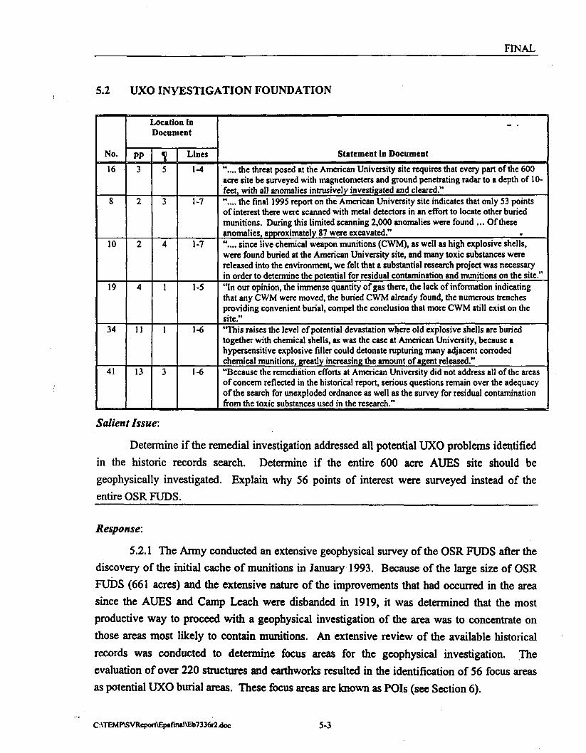
FINAL
5.2 UXO INVESTIGATION FOUNDATION
No.
16
8
10
19
34
41
Location inDocument
PP3
2
2
4
11
13
5
3
4
1
1
3
Lines
1-4
1-7
1-7
1-5
1-6
1-6
Statement in Document
".... the threat posed at the American University site requires that every part of the 600acre site be surveyed with magnetometers and ground penetrating radar to a depth of 10-feet, with all anomalies intrusively investigated and cleared."".... the final 1995 report on the American University site indicates that only 53 pointsof interest there were scanned with metal detectors in an effort to locate other buriedmunitions. During this limited scanning 2,000 anomalies were found ... Of theseanomalies, approximately 87 were excavated."".... since live chemical weapon munitions (CWM), as well as high explosive shells,were found buried at the American University site, and many toxic substances werereleased into the environment, we felt that a substantial research project was necessaryin order to determine the potential for residual contamination and munitions on the site.""In our opinion, the immense quantity of gas there, the lack of information indicatingthat any CWM were moved, the buried CWM already found, the numerous trenchesproviding convenient burial, compel the conclusion that more CWM still exist on thesite."'This raises the level of potential devastation where old explosive shells are buriedtogether with chemical shells, as was the case at American University, because ahypersensitive explosive filler could detonate rupturing many adjacent corrodedchemical munitions, greatly increasing the amount of agent released.""Because the remediation efforts at American University did not address all of the areasof concern reflected in the historical report, serious questions remain over the adequacyof the search for unexploded ordnance as well as the survey for residual contaminationfrom the toxic substances used in the research."
Salient Issue:
Determine if the remedial investigation addressed all potential UXO problems identified
in the historic records search. Determine if the entire 600 acre AUES site should be
geophysically investigated. Explain why 56 points of interest were surveyed instead of the
entire OSR FUDS.
Response:
5.2.1 The Army conducted an extensive geophysical survey of the OSR FUDS after the
discovery of the initial cache of munitions in January 1993. Because of the large size of OSR
FUDS (661 acres) and the extensive nature of the improvements that had occurred in the area
since the AUES and Camp Leach were disbanded in 1919, it was determined that the most
productive way to proceed with a geophysical investigation of the area was to concentrate on
those areas most likely to contain munitions. An extensive review of the available historical
records was conducted to determine focus areas for the geophysical investigation. The
evaluation of over 220 structures and earthworks resulted in the identification of 56 focus areas
as potential UXO burial areas. These focus areas are known as POIs (see Section 6).
C:\TEMP\SVRepoft\Epafiiul\Eb7336r24loc 5-3

FINAL
5.2.2 With the exception of fourteen POIs, all POIs (and thus all potential UXO burial
locations identified in the historic record) were investigated. The 14 that were not investigated
are:
• POIs 30,31, and 32 trenches at Camp Leach - area is now a water reservoir.
• POIs 40,41 and 42 are buildings that still exist on American University campus and
are not considered to be burial locations.
• POIs 44 through 50 and 52 are located on parts of the current American University
campus that have been greatly disturbed over the years as the campus has grown *and
are not considered potential UXO burial locations.
5.2.3 In addition to the archives search and development of the list of POI, an extensive
cut and fill analysis of the AUES and Camp Leach area was conducted (see Section 6.4.1). In
general, in those areas where it was determined that there was more than 10-feet of cut or more
than 12-feet of fill between the 1918 and 1983 (the latest year for USGS topographical
information of the Spring Valley area) surface elevations, the area was deleted from any further
study. The rationale for these exclusions were:
• 10 feet cut - The Army in WWI would not have buried items deeper than 10 feet
(hand digging) and ballistically fired munitions would not have impacted deeper than
10 feet.
• 12 feet fill - It was assumed normal activities, including basement construction,
would not be deeper than 12 feet. Therefore, these activities would not reach the
1918 surface level in areas with 12 feet or greater fill.
5.2.4 After these evaluations were complete, right-of-entry forms were prepared and sent
to property owners to obtain their permission for the Army to engage in the geophysical
investigations on their property. If property owners did not grant right-of-entry, the Army did
not conduct field investigations on these properties.
5.2.5 In addition to the POIs that were geophysically surveyed, "Sample Spot Check
Areas" that did not correspond to a specific POI were geophysically investigated. These areas
consisted of several properties or lots that were randomly selected and usually discontinuous.
Based on the archival investigation, chemical or explosive ordnance was not expected to be
found in these areas. If a large cache of munitions was located in a sample spot check area, the
hypothesis that caches are only associated with identified POIs would be disproven. In this
C:\TEMP\SVReport\EpafinmI\Eb7336r2jJoc 5-4

FINAL
event, the UXO investigation would be expanded to included the entire OSR FUDS. Sample
spot check areas accounted for approximately 10% of the geophysically investigated area. No
munitions caches were found in a sample spot check area. All potential areas of UXO
contamination identified in the Historical Summary were investigated during the RI phase.
Reference:
US ACE, 1994a A Brief History of the American University Experiment Station and US NavyBomb Disposal School, American University. Office of History, Headquarters US ACE. -
US ACE, 1995b. Remedial Investigation Report for the Operation Safe Removal FormerlyUsed Defense Site, Washington DC. Prepared for US Army Corps of Engineers, HuntsvilleDivision and Baltimore District. Prepared by Parsons Engineering Science, Inc.
' C:\TEMP\SVReport\Epafinal\Eb7336r2Uloc 5-5

Section 6

FINAL
SECTION 6
POI IDENTIFICATION AND SELECTION PROCESS
6.1 POI SELECTION RATIONALE
No.
24
55
Location in Document
PP
9
2
2
1
Lines
1-8
1-6,8-11
Statement in Document
"Altogether, there were about 164 structures and earthworks identified by theDistrict and the Corps of Engineers. However, only 53 Points of Interest have*been intrusively investigated. Although some of these points encompassed morethan one structure, many clearly have been omitted. Indeed, many of thesestructures have not been located on any known maps, supporting ourrecommendation that the entire 600 acres needs to be examined (Appendix I)."Letter to USEPA from DCRA"....we have also learned that EPA performed their own analysis of samples takenby the Army from locations at the Spring Valley site. The analysis resultsindicated contamination greater than the EPA recommended Risk-BasedConcentration level for arsenic and other hazardous substances. Both surface andabove ground level air burst testing of experimental chemical agents, manycontaining arsenic, were performed at the site Sample results may not indicatethe presence of arsenic if they were not within the downwind contamination areasof these air burst test sites, however. We are therefore concerned that arsenic andother toxic materials may be present in high concentrations throughout SpringValley and adjacent areas at rather shallow depths.
Salient Issue:
1) Describe the rationale for the identification of the POIs and the selection of certain
POIs for UXO and/or chemical contamination investigations. 2) Determine if all the potentially
hazardous areas were identified and if the entire site needs to be assessed with an environmental
sampling program. Could AUES activities cause contamination to be spread to areas outside the
POIs.
Response:
6.1.1 POI locations were identified and located from the historic record including aerial
photographs. The aerial photographs from 1918, 1927, 1991 and 1993 were merged and
interpreted using state-of-the-art photogrammetric equipment and techniques. This was
accomplished by the US ACE Topographic Engineering Center (TEC). The evaluation of over
220 structures and earthworks resulted in the identification of 56 POIs. A POI is defined as a
specific area of the AUES or Camp Leach most likely to contain UXO or CWM residual
contamination. The OSR FUDS was also divided into nine zones which contain the fifty-six
POIs identified for further investigation. These POIs were determined to be the areas of activity
C:\TEMP\SVRcport\EpafinaI\Eb7336r2.doc 6-1

FINAL
during WWI and the areas most likely to contain contamination as a result of AUES activities.
These included areas which involved the testing and development of CWM and areas that were
used to support AUES activities but did not involve the use of chemicals or ordnance. The_areas
where CWM was tested include circular trench sites where CWM containing munitions were
statically fired and the clouds of agent drifted over the test area. They also include areas where
the historic record indicates CWM was deliberately sprayed or spread over an area for
persistence testing. Also identified were areas near accidents which released contaminants. The
list of POIs also included parts of Camp Leach which was used as a combat engineer training
camp. The locations of the 56 POIs and 9 zones are shown in Figure 6.1. Table 6.1 list the POIs
and summarizes the investigation activities performed at each.
6.1.2 All POIs with the potential to be UXO burial locations were investigated by
geophysical instruments.
6.1.3 The environmental sampling program was focused on those POIs where CWM use
or accidents were documented in the historic record. These are the areas where the highest
concentrations would be expected. No CWM or CWM unique breakdown products or
laboratory contaminants associated with AUES activities were detected in any samples.
Naturally occurring metals which could also be associated with AUES activities were detected at
levels above background concentrations and USEPA Region III Risk Based Concentrations
(RBC). These metals were identified as contaminants of concern and subjected to a baseline risk
assessment in accordance with USEPA Risk Assessment Guidelines for Superfund. The risk
assessment determined these metals were not a hazard. Refer to Section 9 of this report.
Reference:
US ACE, 1995b. Remedial Investigation Report for the Operation Safe Removal Formerly UsedDefense Site, Washington D.C. Prepared for US Army Corps of Engineers, Huntsville Divisionand Baltimore District. Prepared by Parsons Engineering Science, Inc., (Section 5.5.4.1,Page 5-17).
C:\TEMP\SVReport\Epafiiu1\Eb7336r2uloc 6-2

rtaiboradPolntaoflntaroet
1. OroUvTranehao2. PoaeMaPK3. SmafCratarScam4. PowMiPIt5. PooaMtPlt9. PoaaMaTvgatorToetSMa7. PoaaktoTortAraeS. P O H U I TanjotorTart 8Ho9. Pa ooMi fttig or Obaawatan am*10. Po—Ml Tanjrt or T—t 8t«11. Scattered Grand tan12. PeeBWeOredadAraa13. Omar Tranches14. PI18. QmndSear18. ChormsalPeraMenoy Tort Ana17. PoaMtPIIB.19. OUMusBvdflaM20. Ground Sear21. SMPR22. SholPIt23.24.24-R. PretablaPl.RMlMdtooMlon
T26. Smt fCrsMrSon27. PtobaWoTranohorPlch28. PfQOSDav Troncfi or Dfton29. OroundSear30. Tn*ang Trenches31. TraHr« Tranches32. TisMnej Tranches33. TraWngTranehat34. TnMnoj TrtnohM35. TraHnBTranehao36. TraHng Tranches37. MCrook36.39. Stalo Tart Fire Area40. ONoHal41. HatoryBuMng42. PhyaMeeleatLaborai43. OmPtt44. Chi48. D«<oaK»aoUbor1ory48. CamMw Laboratory47. BackvMooleal Laborak49. OaponeloUboraleryJ * D t ^ S * * *
50. OwPtt61. nro> and Rama Laboratory52. BacMyto Laboratory
Named Points of Intofwt
yPooaH* Unoar DaproarionEaMCraok
6010 SadgewtekUnftiaad?Stokaa Mortar
POI Eaat Craak
POIBakarV
UnfUaad Stokaa Mortar \Round Lett by Interti 'Holding A T M
# Point of Intsrwt| — | Point of Interest Boundary| ~ ~ | Zone Boundary• •Bui ld ing
Road/ \ / Camp Leech Boundary^ L f Spring Vafley Boundary
4835 GlenbrookAU Prasldenra ReaMence
TNt map M M prepared for uae of the U.8. Army Corps of Engineer* for BuotraOvapurpoeeeonly. T M B map was created uahgdeta prepared mam venous aourcea.It does not repreeant a survey of the site. The seals, accuracy, and oompletenees of the data Is notguaranteed. NolabMty Is assumed as tofts sufficiency CT accuracyof ihs data ooBeeted hsreon.
PARSONSENGINEERINGSCIENCE, INC.
POINT OF INTERESTOSRFUDS
OPERATION SAFE REMOVAL
SOURCE:USDA, 1978
JOB NUMBER: 731771DOCUMENT NO.:
DAS SHEET:
US Army Corpsof Engineers

FINAL
TABLE 6.1OSR FUDS
POI SUMMARY
POINUMBER
1
2
3
4
5
6
7
8
9
10
11
12
13
14
15
16
17
18
POI NAME
Circular Trenches
Possible Pit
Small Crater Scars
Possible Pit
Possible Pit
Possible Target or Test Site
Possible Test Area
Possible Target or TestArea
Possible Firing orObservation Stalls
Possible Target or Test Site
Scattered Ground Scars
Possible Graded Area
Circular Trenches
Pit
Ground Scar
Chemical PersistencyTest Area
Possible Pit
Small Crater Scars
ZONE
2
2,4
2
2
2
2
2
2
2
2
2
2
1
1
1
1
4
4
GEOPHYSICALSURVEY(I)
X
X
X
X
X
X
X
X
X
X
X
X
X
X
X
X
X
X
INTRUSIVE(I)
X
X
X
X
X
X
X
ENVIRONMENTALSAMPLES
COLLECTED(3)
X
X
X
X
X
X
(6)
X
19 Old Mustard Field 2,3
G:\SHARED\73177 l\FINALRPTVEb7318ip.doc 6-4

FINAL
TABLE 6.1 (Continued)OSR FUDS
POI SUMMARY
POINUMBER
20
21
22
23
24(5)
25
26
27
28
29
30
31
32
33
34
35
36
37
38
POI NAME
Ground Scar
Shell Pit
Shell Pit
Shell Pit
Probable Pit
Possible Trenches
Small Crater Scars
Probable Trench or Ditch
• Probable Trench or Ditch
Ground Scar
Training Trenches(4)
Training Trenches(4)
Training Trenches(4)
Training Trenches
Training Trenches
Training Trenches
Training Trenches
Mill Creek
Bradley Field/MajTolman's Field
ZONE
4
4
4
4
7
4
4
5
5
3
6
6
6
6
6
6
6
8
2
GEOPHYSICALSURVEY0'
X
X
X
X
X
X
X
X
X
X
X
X
X
X
X
X
INTRUSIVE(1)
X
X
X
X
ENVIRONMENTALSAMPLES
COLLECTED(3)
X
X
X m
X
X
X
X
39 Static Test Fire Area
G:\SHARED\73177 l\FINALRPT\EB7322RP.doc 6-5
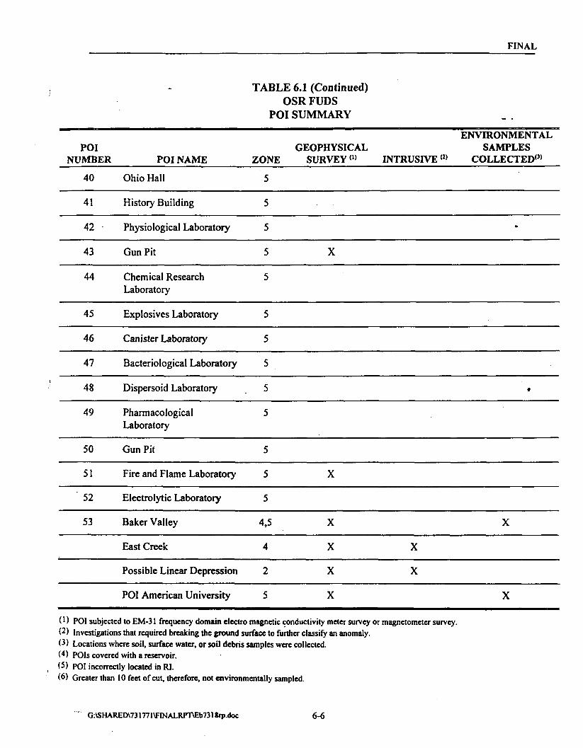
FINAL
TABLE 6.1 (Continued)OSR FUPS
POI SUMMARY
POINUMBER
40
41
42
43
44
45
46
47
48
49
50
51
52
53
POI NAME
Ohio Hall
History Building
Physiological Laboratory
Gun Pit
Chemical ResearchLaboratory
Explosives Laboratory
Canister Laboratory
Bacteriological Laboratory
Dispersoid Laboratory
PharmacologicalLaboratory
Gun Pit
Fire and Flame Laboratory
Electrolytic Laboratory
Baker Valley
East Creek
Possible Linear Depression
POI American University
ZONE
5
5
5
5
5
5
5
5
5
5
5
5
5
4,5
4
2
5
ENVIRONMENTALGEOPHYSICAL SAMPLES
SURVEY(1) INTRUSIVE(2) COLLECTED'3'
•
X
•
X
X X
X X
X X
X X
(') POI subjected to EM-31 frequency domain electro magnetic conductivity meter survey or magnetometer survey.(2) Investigations that required breaking the ground surface to further classify an anomaly.(3) Locations where soil, surface water, or soil debris samples were collected.W POIs covered with a reservoir.(5) POI incorrectly located in RI.(6) Greater than 10 feet of cut, therefore, not environmentally sampled.
""- G:\SHARED\731771\FrNALRPT\Eb7318ip.doc 6-6

FINAL
6.2 OLD MUSTARD FIELD
No.
37
Location in DocumentPP10
I3
Lines
1-3
Statement in Document
".... one Point of Interest identified previously was the Old Mustard Field, a 500 footdiameter area covered repeatedly with mustard gas."
Salient Issue:
Determine if the "Old Mustard Field" referred to is POI 19.
Response:
6.2.1 POI 19 is the "Old Mustard Field". POI 19 was identified on a map titled "Range
and Reservation American University Experiment Station Research Division of the Chemical
Warfare Service", dated July 1918. The map was included in Vol. 2 of the 1986 EPIC report.
The area was an oval circle marked "Old Mustard Field" [OSR FUDS RI report Section 3.2.5,
page 3-13 (USACE, 1995b)]. POI 19 was part of the surficial soil sampling program; the
thirteen soil samples collected from this 458 foot diameter POI were analyzed for mustard,
mustard breakdown products, lewisite as chlorovinylarsenious acid, and total cyanide. No
chemical agents or their breakdown products were detected in any of the samples collected from
POI 19 [OSR FUDS RI report Section 6.3.5, page 6-15 (USACE, 1995b)].
Reference:
USACE, 1995b. Remedial Investigation Report for the Operation Safe Removal Formerly UsedDefense Site, Washington D.C. Prepared for US Army Corps of Engineers, Huntsville Divisionand Baltimore District. Prepared by Parsons Engineering Science, Inc.
G:\SHAREDV731771\FINALRPrr\EB7322RP.doc 6-7

FINAL
6.3 POI SELECTION BASED ON HISTORICAL RECORD
6.3.1 Releases
No.
6
Location in Document
PP2
11
Lines
7-10
Statement in Document
"Many of these experiments involved releasing great quantities of these toxicsubstances into the air and on the soil to see the effects on animals placed at variousdistances from the release point."
Salient Issue:
Determine if there is evidence that large quantities of CWM were released into the air
and drifted beyond the experiment area.
Response:
6.3.1.1 The controlled chemical agent releases were conducted in test areas northwest of
the campus, a good distance away from the lab complex located on what is now American
University (AU) property (POIs 01,13,15,16,19 and 38). The primary safety precaution taken
during the testing was to stay 100 yards away from Massachusetts Avenue. Traffic was allowed
to continue on Massachusetts Avenue during the testing because it was thought that 100 yards
was far enough away that it would not bother the civilian traffic (Carleton, 1918). In addition to
the controlled releases, there were also several accidents on the AU campus where CWM or
CWM components were released into the air. These accidental releases were the result of
building fires or explosions [OSR FUDS RI report Section 3.2.8 (USACE, 1995b)].
6.3.1.2 Only one incident, a probable accidental lewisite release on August 3, 1918, was
known to have affected residents southeast of the AUES. On August 3, 1918, an explosion
occurred at Manufacturing Shack #8. Manufacturing Shack #8 was located in the southwest
portion of the AUES in the middle of the current American University baseball field. The
explosion occurred in a still during gas distillation. Approximately 8-10 pounds of the gas were
released after the still exploded. Three men working at the shack were exposed and a cloud of
agent was carried by the wind in a southeasterly direction for about 1,200 feet. Although the
chemical composition of the agent is not described, it is most likely that lewisite was being
distilled instead of mustard as previously thought during the OSR FUDS RI report [OSR FUDS
RI report Section 3.2.8, page 3-16 through 3-18 (USACE, 1995b)] (AU Archives, letter dated
September 24, 1971). The residents requested immediate medical attention and received it from
AUES doctors, but were not hospitalized due to the exposure (USACE, 1994a). This accidental
release site was identified as Baker Valley, POI 53, Zone 4. This accidental release area was the
K:\SHARED\731771\FINALRFnEB7336RlJX)C 6-8

FINAL
western edge of the Experiment Station based on a 1918 plan map of buildings on the AUES
campus and the stated wind direction. Thirteen soil samples were collected from Baker Valley
(POI 53) during the surficial soil sampling. The thirteen soil samples collected from POI 53
were analyzed for mustard, mustard breakdown products, lewisite as chlorovinylarsenious acid,
and total cyanide. No chemical agents or their breakdown products were detected in any of the
samples collected from Baker Valley (USACE, 1995b).
6.3.1.3 The majority of the accidents were confined to the AUES grounds, in the area
that is now a baseball field and athletic fields of the American University. This part of the
American University campus where temporary laboratories and temporary building were
constructed was designated POI American University. Thirteen soil samples were collected
from this POI during the surficial soil sampling. No CWM or CWM unique breakdown
products or laboratory contaminants associated with AUES CWM research and development
were detected in any sample collected from POI American University.
6.3.1.4 However, some metals, volatile organic compounds (VOCs) and semi-volatile
organic compounds (SVOCs) were detected [OSR FUDS RI Section 6.6.3, pages 6-37 through
6-41 (USACE, 1995b)]. When these results were compared to screening USEPA Region III
RBCs, nine metals (aluminum, antimony, arsenic, beryllium, cadmium, manganese, mercury,
nickel, and vanadium) and three polynuclear aromatic hydrocarbons (PAHs) were found to be
present at concentrations greater than screening RBCs.
6.3.1.5 The PAHs were detected in only one sample and are considered to be the result
of more recent activities and not historical AUES activities; therefore, they are not considered
"chemicals of potential concern." PAHs are commonly associated with automobile exhaust.
The location of the samples was adjacent to a parking lot.
6.3.1.6 Statistical analyses of the metals determined that the concentrations of five
(aluminum, beryllium, cadmium, nickel, and vanadium) of nine metals compared to background
were significantly different than background at the 95 percent confidence interval; therefore,
these metals were considered "chemicals of potential concern" at the American University POI.
None of these elements are believed to be associated with World War I activities. The risk
assessment concluded that no further remedial actions at the OSR FUDS are necessary due to
the presence of these metals in Zone 5 [OSR FUDS RI Report Section 8.6.2, pages 8-38 through
8-41 and Section 9.1.5, pages 9-3 through 9-4 (USACE, 1995b)].
K:\SHARED\731771\FINALRrr\EB7336Rl.DOC 6-9

FINAL
6.3.1.7 The environmental sampling program was focused on those POIs where
chemical agent use or accidents were documented in the historic record. These are the areas
where the highest concentrations would be expected. No CWM or CWM unique breakdown
products were detected in any samples. Naturally occurring metals which could also be
associated with AUES activities and many which could not be associated with AUES activities
were detected at levels above background concentrations and USEPA Region HI Risk Based
concentrations. These metals were identified as contaminants of concern and subjected to a
baseline risk assessment in accordance with USEPA Risk Assessment Guidelines for Superfund
(USEPA, 1989a). The risk assessment determined these metals were not a hazard. Refetto
Section 9 of this report.
Reference:
American University Archives, Letter dated September 24, 1971. Letter from Burton Logue tohis sister.
Carleton, 1918. Report of Field Experiments on Persistency ofG-34. American UniversityExperiment Station.
US ACE, 1994a A Brief History of the American University Experiment Station and US NavyBomb Disposal School, American University. Office of History, Headquarters USACE.
US ACE, 1995b. Remedial Investigation Report for the Operation Safe Removal FormerlyUsed Defense Site, Washington D.C. Prepared for US Army Corps of Engineers, HuntsvilleDivision and Baltimore District. Prepared by Parsons Engineering Science, Inc.
USEPA, 1989a. Risk Assessment Guidance for Superfund: Volume 1 - Human HealthEvaluation (Part A). Washington, DC: Office of Emergency and Remedial Response.EPA/540/1-89/002.
K:\SHARED\731771\FINALRPT\EB7336R1.DOC 6-10

FINAL
6.3.2 UXO Burial Locations
No.
19
37
47
49
Location in Document
PP4
12
16
17
111
1
4
2
Lines
1-5
3-6
1-8
1-5
Statement in Document ~ '
"In our opinion, the immense quantity of gas there, the lack of information indicatingthat any CWM were moved, the buried CWM already found, the numerous trenchesproviding convenient burial, compel the conclusion that more CWM still exist on thesite."There are two potential sources for gas exposure at American University: (1)individual unexploded ordnance resulting from the dispersion testing; and (2) gasshells and cylinders, intentionally buried, when the operation ended.""Fourth, there were rumors of large scale burial of munitions at the site. In theHistorical Report it states, The USATHAMA (US Army Toxic and Hazardous „Materials Agency) study incorporated materials from American University and •concluded that there was no evidence to confirm rumored large-scale burials ofmunitions. But it did highlight two sites that would be likely candidate locations ifburial had occurred.""Not only is there no evidence that the 'enormous quantities' of toxic substances andmunitions known to have been there, were moved, but these two memoranda seem toindicate that the chemical and explosive munitions were not moved to the ordnancedepartment facilities at Aberdeen."
Salient Issue:
Determine if all known potential trench locations were identified. Determine if all
potential UXO burial locations were identified. Determine if all potential burial locations
identified in the historical record, including the two sites identified in the USATHAMA report,
were investigated.
Response:
6.3.2.1 The primary source for information on potential burial locations is the analysis
of a 1918 aerial photograph. The analysis of the photograph initially identified 36 POIs. The
POIs included potential burial locations identified as pits and trenches dug during AUES
activities. Some of the pits and trenches were associated with Camp Leach (Zone 6), a combat
engineer training camp closed before the AUES was closed. No evidence suggested that CWM
was used at Camp Leach. Included in these 36 Points of Interest are the two double ring
trenches identified on page 14 of the EPIC report Historical Photographic Analysis, American
University Washington, D.C. (USEPA, 1986) as potential burial locations. These trenches were
identified as POI 1 and POI 13 during the PA. The locations of additional POIs were found
during the historical record investigation. At the end of the historical investigation 56 POIs
were identified. Appendix A of The Historical Summary (US ACE, 1994a) is a summary of the
sources reviewed by US ACE. Appendix B of The Historical Summary (USACE, 1994a) is a
summary of the Federal record reviewed by USACE.
K:\SHARED\731771\FINALRPT\EB7336R1.DOC 6-11

FINAL
6.3.2.2 With the exception of fourteen POIs, all POIs (and thus all potential UXO burial
locations are identified in the historic record) were investigated. The 14 that were not
investigated are:
• POIs 30, 31, and 32 trenches at Camp Leach in the area that is now a water reservoir.
• POIs 40, 41 and 42 are buildings (Ohio Hall, History Building, and Physiological
Laboratory) that still exist on American University campus and are not considered to
be burial locations.
• POIs 44 through 50 and 52 are located on parts of the current American University
campus that have been greatly disturbed over the years as the campus has grown and
are not considered potential UXO burial locations.
6.3.2.4 After an exhaustive review of the historical record (i.e. photographs, military and
civilian archives, test reports, military and civilian correspondence, etc.) 56 POIs were identified
at the OSR FUDS. These POIs included any and all potential UXO burial locations as revealed
in the historic record. All POIs with the potential to contain buried UXO caches have been
investigated.
Reference:
US ACE, 1994a A Brief History of the American University Experiment Station and US NavyBomb Disposal School, American University. Office of History, Headquarters US ACE.
US ACE, 1995b. Remedial Investigation Report for the Operation Safe Removal Formerly UsedDefense Site, Washington D.C. Prepared for US Army Corps of Engineers, Huntsville Divisionand Baltimore District. Prepared by Parsons Engineering Science, Inc. (OSR FUDS RI,Section 3).
USEPA, 1986 Historical Photographic Analysis, American University Washington, D.C.Prepared for USATHAMA. Prepared by USEPA EPIC.
K:\SHARED\731771\FINALRPT\EB7336R1.DOC 6-12

FINAL
6.4 POI PLACEMENT
6.4.1 Map Accuracy - •
6.4.1.1 As discussed in Section 6.1, POIs were identified and located from the historic
record using various photogrammetric techniques. The location of the POIs were placed relative
to features common throughout the 75 year span (e.g., Massachusetts Avenue, AU building
locations, and trees) and digital computations. Ground control was established through 23
photo-identifiable points in the 1991 and 1993 photographs which were surveyed. The
positional accuracy of the POIs is ±2.6 meters to ±5 meters.
6.4.1.2 During this current review of the OSR FUDS RI, it was determined the location
of POI 24 as environmentally sampled was based on a TEC Interim Work Product POI Location
Map. TEC had further investigated the POIs and refined the POI interpretations and locations
resulting in a more accurate TEC Final POI Location Map produced in April 1993. The
centerpoint coordinates of fourteen POIs (12, 17, 20-24, 26-27, 29-31, 33, and 36) were refined
from the locations on the interim map product.
6.4.1.3 During the current RI review, these fourteen POI locations were reviewed using
an original copy of the TEC Final POI Location Map with the POIs shown on a circa 1991
aerial photo of the site and an Arclnfo Geographic Information System (GIS) coverage of the
site. The POIs on the photo were compared to the POI locations on the GIS coverage with
houses shown. This allowed accurate comparison of the POI locations on both products. The
lots were then compared to the Surveyed Properties and POIs figures in Section 6 of the RI for
geophysical investigations, and the lot report (POI 20) for soil sample locations. All the POIs,
except for POI 24, were accurately located in the OSR FUDS RI Report and appropriately
investigated.
6.4.1.4 The location and identification of POI 24 as a ground scar were incorrect as
environmentally sampled on January 6 and 7, 1994, because it was based on the TEC Interim
Work Product POI Location Map. POI 24 was identified as a probable pit on the TEC Final POI
Location Map and the correct location was geophysically surveyed with an EM-31 on April 5
through April 7, 1994, as part of the 10% QA/QC sampling. All anomalies were investigated
and determined to be construction debris.
6.4.1.5 Cut and fill maps were generated by merging 1918 and 1983 topographic maps.
The maps were digitized and then horizontally aligned by features common to both maps (e.g.,
K:\SHAREDV731771\FINALRFT\EB7336R1.DOC 6-13

FINAL
roads, street intersections and buildings). The vertical alignment was performed by digitally
correcting for scale followed by a comparison of the contour lines. Vertical alignment was also
confirmed by identifying two peak elevations with no apparent change between 1918 and 1591.
6.4.1.6 The accuracy of the cut and fill maps is not documented. However, during soil
sampling in areas with fill, field geologists collected samples at the depth where noticeable
changes in lithology indicated the 1918 surface had been reached as documented in the field
notes. In most cases, the actual sample depth was within one-foot of the planned depth, which
was based on the cut and fill map. Table 6.2 is a summary of the actual depths at which samples
were collected and the depths that were planned based on the cut and fill analysis.
Reference:
Engineering Science, June 24, 1993. Letter from Carl Drummond, Engineering Science toSpring Valley GIS File, Engineering Science. Subject: Rationale for Determining Horizontaland Vertical Datums, 1918 and 1991 Topography. Engineering Science Inc.
USACE-TEC, 1994a. The Use of Digital Photogrammetric Methods in Historical PhotoAnalysis. 1994 ASPRS/ACSM Annual Convention and Exposition, Technical Papers, Reno,Nevada April 25-28, Volume 1.
K:\SHARED\731771\FINALRPT\EB7336R1.DOC 6-14

TABLE 6.2COMPARISON OF PREDICTED DEPTH TO 1918 GROUND SURFACE WITH
OSR FUDS SOIL SAMPLE DEPTHSOSR FUDS
Zone
54/51155555224441
2/34444255
4/5222
Pointof
Interest
Amer. U.BAKERPOI 16POI 16
Amer. U.Amer. U.Amer. U.Amer. U.Amer. U.BF/MTFBF/MTF
POI21/22/23POI21/22/23POI21/22/23
POI 16POI 19
POI21/22/23POI21/22/23POI21/22/23POI21/22/23
POI 10/11Amer. U.Amer. U.BAKERBF/MTFPOI 01POI 01
SampleName
SV-BAKER-04SV-BAKER-04SV-POI16-12SV-POI 16-11SV-AU-09SV-AU-02SV-AU-03SV-AU-01SV-AU-06SV-BFMT-02SV-BFMT-06SV-POI21/23-07SV-POI21/23-06SV-PO121/23-05SV-POI16-07SV-POI 19-09SV-POI21/23-08SV-POI21/23-04SV-POI21/23-03SV-POI21/23-02SV-POI 10/11-08SV-AU-04SV-AU-05SV-BAKER-05SV-BFMT-05SV-POI01-14SV-POI01-06
CollectionDate
01/05/9401/05/9401/24/9401/24/9401/07/9401/04/9401/04/9401/04/9401/05/9402/15/9402/16/9412/08/9312/08/9312/08/9301/21/9403/02/9412/08/9312/07/9312/07/9312/07/9301/26/9401/04/9401/04/9401/05/9402/15/9402/02/9401/31/94
SampleMatrix
SoilSoilSoilSoilSoilSoilSoilSoilSoilSoilSoilSoilSoilSoilSoilSoilSoilSoilSoilSoilSoilSoilSoilSoilSoilSoilSoil
SampleLocation
AU Grid Cell H6Baker Valley Grid Cell L13POI 16 Grid Cell E12POI16 Grid Cell E13AU Grid Cell D9AU Grid Cell OilAU Grid Cell 012AU Grid Cell PllAU Grid Cell 17BF/MTF Grid Cell D7BF/MTF Grid Cell G2POI 21/22/23 Grid Cell C-4POI 21/22/23 Grid Cell C-5POI 21/22/23 Grid Cell E-5POI 16 Grid Cell B12POI 19 Grid Cell G9POI 21/22/23 Grid Cell C-3POI 21/22/23 Grid Cell E-7POI 21/22/23 Grid Cell F-8POI 21/22/23 Grid Cell G-9POI 10/11 Grid Cell M5AU Grid Cell J10AU Grid Cell K9Baker Valley Grid Cell 114BF/MTF Grid Cell H4POI01 Grid Cell 16POI01 Grid Cell Jl l
RelativeDepth of
1918
(ft)
14146654444444444433333222222
PlannedSampleDepth
(ft)
141466544444444444333332222 j
2*2
ActualSampleDepth
(ft) Comments
13.0-14.0 Baker Valley Grid Cell LI13.0-14.05.5-6.55.5-6.55.5-6.53.5-4.53.5-4.53.5-4.53.5-4.53.5-4.53.5-4.5 Analyzed as MS/MSD
444
3.5-4.53.5-4.5
32-41-21-2
2.5-3.51.5-2.51.5-2.50.5-1.51.5-2.5 !2.0-3.02.0-3.0
G:VOBS\728\728326\Sb7192ja

TABLE 6.2 (Continued)
COMPARISON OF PREDICTED DEPTH TO 1918 GROUND SURFACE WITH
OSR FUDS SOIL SAMPLE DEPTHS
OSR FUDS
Zone
22222111
2/32/32/32/344
4/5242222
2/344524
Point
ofInterest
POI 01
POI 01
POI 01
POI 01POI 01
POI 16
POI 16POI 16POI 19POI 19POI 19POI 19POI 20
POI 20BAKER
BF/MTF
POI21/22/23
POI 01POI 01
POI 01
POI 10/11POI 19
POI 20POI 20
Amer. U.
BF/MTF
POI21/22/23
Sample
Name
SV-POI01-04
SV-POI01-05
SV-POI01-03SV-POI01-11
SV-PO101-02SV-POI 16-06
SV-POI 16-09SV-POI 16-03SV-POI 19-08SV-POI 19-06SV-POI 19-05SV-POI 19-02
SV-POI20-12SV-POI20-10SV-BAKER-10
SV-BFMT-01SV-POI21/23-09SV-POI01-08SV-POI01-07
SV-POI01-01SV-POI10/11-06
SV-POI19-14
SV-POI20-02
SV-POI20-14
SV-POI24-12
SV-BFMT-03SV-POI21/23-14
CollectionDate
01/31/94
01/31/94
01/31/94
02/01/9401/31/94
01/21/9401/21/9401/21/94
03/02/9403/02/9403/02/9403/01/9403/05/94
03/05/9403/09/94
02/15/94
12/08/9302/01/9402/01/94
01/31/9401/26/94
03/03/94
03/04/94
03/08/9401/06/94
02/15/94
12/09/93
Sample
Matrix
Soil
Soil
Soil
Soil
Soil
SoilSoilSoilSoilSoilSoilSoilSoil
SoilSoil
SoilSoilSoilSoil
Soil
SoilSoil
Soil
Soil
Soil
Soil
Soil
Sample
Location
POI01 Grid Cell Kl l
POI01 Grid Cell L9
POI01 Grid Cell Mi l
POI01GridCelIM15
POI01 Grid Cell 013POI 16 Grid Cell A9POI 16 Grid Cell B14POI 16 Grid Cell D8POI 19 Grid Cell G12POI19GridCellG15POI 19 Grid Cell J14POI19 Grid Cell P12POI20 Grid Cell J10
POI20 Grid Cell M14Baker Valley Grid Cell PI 1
BF/MTF Grid Cell B8POI 21/22/23 Grid Cell C-lPOI01 Grid Cell G12POI01 Grid Cell H12
POI01 Grid Cell 0 8
POI 10/11 Grid Cell 0 2
POI 19 Grid Cell N9POI20 Grid Cell E2
POI20 Grid Cell G9AU Grid Cell N6
BF/MTF Grid Cell G7
POI 21/22/23 Grid Cell M-15
Relative
Depth of
1918
(ft)
222222222222221111
000
Planned
Sample
Depth
(ft)
22222222222222
<<<
1.54
1.5
Actual
SampleDepth
(ft) Comments
2.0-3.0
2.0-3.0 MS/MSD Sample
2.0-3.02.0-3.0
2.0-3.0
1.5-2.51.5-2.5
1.5-2.51.5-2.52.5-3.51.5-2.51.5-2.5
0.5-1.51.5-2.52.5-4.0
0.5-1.52-4
1.0-2.01.0-2.0
1.0-2.0
1.0-2.0
1.0-2.00.5-1.5 Analyzed as MS/MSD
0.5-1.50.5-1.5 POI 24 Grid Cell H8
0.5-1.54
G:\JOBS\728\728326\Sb7l92ja

TABLE 6.2 (Continued)COMPARISON OF PREDICTED DEPTH TO 1918 GROUND SURFACE WITH
OSR FUDS SOIL SAMPLE DEPTHSOSR FUDS
Zone
2222222211I1
2/32/34444555555555
Pointof
Interest
POI 01POI 01POI 01POI 07
POI 10/11POI 10/11POI 10/11POI 10/11
POI 16POI 16POI 16POI 16POI 19POI 19POI 20POI 20POI 20POI 20POI241
POI 241
POI 241
POI 24*POI 24'POI 24'POI 24'POI 24'POI 24'
SampleName
SV-POI01-12SV-POI01-10SV-POI01-13SV-POI07-07SV-POI 10/11-04SV-POI10/U-13SV-POI 10/11-02SV-POI 10/11-01SV-POI 16-08SV-POI 16-04SV-POI16-13SV-POI 16-01SV-POI 19-10SV-POI 19-04SV-POI20-04SV-POI20-03SV-POI20-01SV-POI20-13SV-POI24-01SV-POI24-03SV-POI24-04SV-POI24-05SV-POI24-06SV-PO124-07SV-POI24-08SV-POI24-09SV-POI24-13
CollectionDate
02/01/9402/01/9402/02/9402/09/9401/25/9401/27/9401/25/9401/25/9401/21/9401/21/9401/24/9401/19/9403/02/9403/01/9403/04/9403/04/9403/04/9403/08/9401/06/9401/06/9401/06/9401/06/9401/06/9401/06/9401/06/9401/06/9401/07/94
SampleMatrix
SoilSoilSoilSoilSoilSoilSoilSoilSoilSoilSoilSoilSoilSoilSoilSoilSoilSoilSoilSoilSoilSoilSoilSoilSoilSoilSoil
SampleLocation
POI01 Grid Cell C14POI01 Grid Cell H17POI01 Grid Cell L4POI07 Grid Cell A4POMO/11 Grid Cell D7POI 10/11 Grid Cell E5POI 10/11 Grid Cell H14POI 10/11 Grid Cell J14POI16 Grid Cell C14POI 16 Grid Cell C9POI 16 Grid Cell G9POI 16 Grid Cell H3POI 19 Grid Cell J9POI 19 Grid Cell M14POI20 Grid Cell A6POI20 Grid Cell D4POI20 Grid Cell F5POI20 Grid Cell H6POI24 Grid Cell B15POI24 Grid Cell C12POI24 Grid Cell F13POI24 Grid Cell G2POI24 Grid Cell H5POI24 Grid Cell J4POI24 Grid Cell K7POI24 Grid Cell L8POI24 Grid Cell M5
Relative PlannedDepth of Sample
1918 Depth(ft) (ft)
0 <1.50 <1.50 <1.50 <1.50 <1.50 <1.50 <1.50 <1.50 <1.50 <1.50 <1.50 <1.50 <1.50 <1.50 <1.50 <1.50 <1.50 <1.50 <1.50 <1.50 <1.50 <1.50 <1.50 <1.50 <1.50 < f.50 <1.5
ActualSampleDepth
(ft) Comments
0.5-1.51.0-2.00.5-1.50.5-1.50.5-1.50.5-1.50.5-1.50.5-1.50.5-1.50.5-1.5 Analyzed as MS/MSD1.5-2.50.5-1.50.5-1.50.5-1.50.5-1.50.5-1.50.5-1.50.5-1.50.5-1.5 MS/MSD Sample0.5-1.50.5-1.50.5-1.50.5-1.50.5-1.50.5-1.5 !0.5-1.50.5-1.5
G:\JOBS\728\72S326\Sb7l92ja

TABLE 6.2 (Continued)
COMPARISON OF PREDICTED DEPTH TO 1918 GROUND SURFACE WITH
OSR FUDS SOIL SAMPLE DEPTHSOSR FUDS
Zone
554222
2/32/35555
4/54/54442222222211
Point
ofInterest
POI 24*
POI241
POI21/22/23POI 07POI 07
POI 10/11POI 19POI 19POI241
POI 24'Amer. U.Amer. U.
BAKERBAKER
POI21/22/23
POI21/22/23
POI21/22/23
POI 07POI 07POI 07
POI 07
POI 07
POI 07
POI 10/11
POI 10/11
POI 16
POI 16
Sample
Name
SV-POI24-12
SV-POI24-10
SV-POI21/23-01
SV-POI07-03SV-POI07-01SV-POI 10/11-07SV-POI 19-13SV-POI19-01SV-POI24-14SV-POI24-11
SV-AU-07
SV-BAKER-03SV-BAKER-08
SV-BAKER-03
SV-POI21/23-13
SV-POI21/23-15SV-POI21/23-12SV-PO107-08SV-POI07-06
SV-POI07-05SV-POI07-04
SV-POI07-11
SV-POI07-09SV-POI10/11-14
SV-POI10/11-12
SV-POI16-10SV-POI16-14
Collection
Date
01/07/94
01/06/94
12/07/9302/08/9402/08/9401/26/9403/03/9403/01/9401/07/9401/07/9401/06/9401/04/9403/09/94
01/04/94
12/09/93
12/09/9312/08/9302/09/9402/08/9402/08/94
02/08/94
02/10/94
02/09/9401/27/94
01/27/9401/24/94
01/24/94
Sample
Matrix
Soil
Soil
SoilSoilSoilSoilSoilSoilSoilSoilSoilSoilSoilSoil
Soil
Soil
SoilSoilSoilSoil
Soil
Soil
Soil
SoilSoil
Soil
Soil
Sample
Location
POI24 Grid Cell M6
PO124 Grid Cell M8
POI 21/22/23 Grid Cell G-12POI07 Grid Cell C7POI07 Grid Cell D7POI 10/11 Grid Cell M3POI 19 Grid Cell C9POI19GridCellP15
POI24 Grid Cell 0 6POI24 Grid Cell O7AU Grid Cell M5AU Grid Cell J9Baker Valley Grid Cell K7
Baker Valley Grid Cell M16POI 21/22/23 Grid Cell 0-15
POI 21/22/23 Grid Cell J-15POI 21/22/23 Grid Cell Q-14
POI07 Grid Cell C4POI07 Grid Cell D4
POI07 Grid Cell D5
POI07 Grid Cell D6POI07 Grid Cell N14
POI07 Grid Cell P14
POI 10/11 Grid Cell C3POI 10/11 Grid Cell F4
POI16 Grid Cell A16
POI 16 Grid Cell Q3
Relative Planned
Depth of Sample
1918 Depth
(ft) (ft)
0 <1.5
0 <1.5-1 <1.5
-1 <1.5-1 < 1.5
--
<1.5<1.5<1.5
<1.51 <1.5
-2 <1.5-2 <1.5
-2 <1.5-2 <1.5
-2 < 1.5
-2 <1.5-2 <1.5
-2 <1.5-2 <1.5-2 <1.5
-2 <1.5
-2 < 1.5-2 < 1.5
-2 <1.5-2 <1.5
-2 < 1.5
-2 < 1.5
Actual
Sample
Depth(ft) Comments
0.5-1.5
0.5-1.5
1-20.5-10.5-10.5-10.5-1
0.5-10.5-10.5-10.5-10.5-0.5-
0.5-
.5
.5
.5 Analyzed as MS/MSD
.5
.5
.5
.5
.5 MS/MSD Sample
.5 Baker Valley Grid Cell Ml
.51.5
444
0.5-0.5-
0.5-
0.5-
0.5-
i.o-:0.5-0.5-
0.5-
.51.51.51.51.5 Analyzed as MS/MSD
2.01.51.5 !1.5
1.5-2.5
G:VOBS\728\72«326\Sb7192ja

TABLE 6.2 (Continued)
COMPARISON OF PREDICTED DEPTH TO 1918 GROUND SURFACE WITH
OSR FUDS SOIL SAMPLE DEPTHS
OSR FUDS
Zone
2/32/32/3444
4/52225
4/54/54/522221
4/525
4/54/54/522
Point
ofInterest
POI19
POI19
POI 19
POI20
POI 20
POI 20BAKERBF/MTFPOI 07
POI 10/11Amer. U.BAKERBAKER
BAKER
BF/MTFPOI 07
POI 07POI 10/11
POI 16BAKER
POI 10/11
Amer. U.
BAKERBAKER
BAKER
' BF/MTF
POI 07
SampleName
SV-POI19-11
SV-POI19-12
SV-POI19-03
SV-POI20-05SV-POI20-08
SV-POI20-11SV-BAKER-07
SV-BFMT-07SV-POI07-12SV-POI10/11-03SV-BAKER-05SV-BAKER-02SV-BAKER-12
SV-BAKER-06A
SV-BFMT-08SV-POI07-14
SV-POI07-10SV-POI10/11-05SV-POI 16-02
SV-BAKER-01
SV-POI10/11-11
SV-AU-10
SV-BAKER-06
SV-AU-10
SV-BAKER-11
SV-BFMT-14
SV-POI07-13
CollectionDate
03/03/94
03/03/94
03/01/94
03/04/94
03/05/94
03/05/9403/08/94
02/16/9402/10/9401/25/9401/05/94
12/10/9303/09/94
03/08/9402/16/94
02/10/94
02/09/9401/25/9401/19/94
12/09/9301/27/94
01/07/94
01/07/94
01/07/9403/09/94
02/17/94
02/10/94
SampleMatrix
Soil
Soil
Soil
Soil
SoilSoilSoilSoilSoilSoilSoilSoilSoilSoil
Soil
Soil
SoilSoilSoilSoil
Soil
Soil
Soil
SoilSoil
Soil
Soil
SampleLocation
POI19 Grid Cell G3
POI 19 Grid Cell 15
POI19GridCellN15
POI20 Grid Cell C9POI20Grid Cell Mil
POI20 Grid Cell P15Baker Valley Grid Cell K3BF/MTF Grid Cell L4POI07 Grid Cell N13POI 10/11 Grid Cell G9AU Grid Cell D7Baker Valley Grid Cell C12Baker Valley Grid Cell 14
Baker Valley Grid Cell J3
BF/MTF Grid Cell 08POI07 Grid Cell L12
POI07 Grid Cell P13POI10/11 Grid Cell 16POI 16 Grid Cell G2Baker Valley Grid Cell G i l
POMO/11 Grid Cell H3
AU Grid Cell B9
Baker Valley Grid Cell Cl5
Baker Valley Grid Cell HI6Baker Valley Grid Cell N4
BF/MTF Grid Cell F13
POI07 Grid Cell N12
Relative
Depth of1918
(ft)
-2-2-2-2-2-2-3-3-3-3-4-4-4-4-4-4-4-4-4-5-5-6-6-6-6-6-6
Planned
SampleDepth
(ft)
<1.5
<1.5
<1.5
<1.5
<1.5
<1.5<1.5<1.5<1.5<1.5<1.5<1.5<1.5
<1.5
<1.5<1.5
<1.5<1.5<1.5<1.5
<1.5
<1.5
<1.5
<1.5<1.5
<1.5
<1.5
Actual
SampleDepth
(ft)
0.5-1.5
0.5-1.5
0.5-1.5
0.5-1.5
0.5-1.5
0.5-1.50.5-1.50.5-1.50.5-1.50.5-1.50.5-1.51.5-2.51.5-2.50.5-1.5
0.5-1.51.0-2.0
0.5-1.50.5-1.50.5-1.51.0-2.0
0.5-1.5
0.5-1.5
1.5-2.5
1.5-2.5
0.5-1.5
0.5-1.5
0.5-1.5
Comments
Analyzed as MS/MSD
Baker Valley Grid Cell 114
Analyzed as MS/MSD
Baker Valley Grid Cell A1
Also AU Grid Cell B9i
G:\JOBS\728\728326\Sb7192ja

TABLE 6.2 (Continued)COMPARISON OF PREDICTED DEPTH TO 1918 GROUND SURFACE WITH
OSR FUDS SOIL SAMPLE DEPTHSOSR FUDS
>ne
24422222
Pointof
Interest
PO! 10/11POI20POI 20
BF/MTFBF/MTFBF/MTFBF/MTFBF/MTF
SampleName
SV-POI10/11-10SV-POI20-07SV-POI20-06SV-BFMT-13SV-BFMT-10SV-BFMT-09SV-BFMT-11SV-BFMT-12
CollectionDate
01/26/9403/05/9403/05/9402/17/9402/17/9402/16/9402/17/9402/17/94
SampleMatrix
SoilSoilSoilSoilSoilSoilSoilSoil
SampleLocation
POI10/11 Grid Cell J4POI20 Grid Cell 08POI20 Grid Cell P10BF/MTF Grid Cell G15BF/MTF Grid Cell K10BF/MTF Grid Cell 110BF/MTF Grid Cell M15BF/MTF Grid Cell Kl5
RelativeDepth of
1918
(ft)
-6-6-6-7-8-9-11-12
PlannedSampleDepth
(ft)
<<<<<<<<
.51.51.51.5.5.5.5
1.5
ActualSampleDepth
(ft)
0.5-0.5-0.5-0.5-0.5-0.5-0.5-0.5-
1.5.5.5.5.5.5.5.5
Comments
©
Notes:MS/MSD = Matrix Spike/Matrix Spike DuplicateNA = Not ApplicablePOI = Point of InterestBF/MTF = Bradley Field/Major Tolmans FieldBaker = Baker ValleyAmer. U. = American UniversityLTC B. = LTC Bancroft Area
'POI 24 Incorrect Location
G:VJOBS\728\728326\Sb7192ja

Section 7

FINAL
SECTION 7
UXO INVESTIGATION/REMOVAL PROGRAM
7.1 MUNITION FIND
No.
12
Location in DocumentPP
312
Lines
1-6
Statement in Document
"Subsequently, on April 2,1996, another live munition (incendiary whitephosphorous?) was found. The District of Columbia Department of Consumer andRegulatory Affairs, Environmental Regulation Administration (ERA) was notinformed of this event until April 19,1996. We have now been told that this shell wasfound inside of a house."
Salient Issue:
Determine if this munition is a documented find and is a result of AUES activities.
Response:
7.1.1 This round is a documented find and is a result of AUES activities. The OE item
was located adjacent to the house at 5010 Sedgewick. The home owner was adding onto his
house and the contractor dug it up. The DC Metro Police Department called the 57th EOD unit
at Belvoir. The 57th EOD at Ft. Belvoir responded to the request for assistance from the DC
Metro Police Department for the removal of the ordnance item at 5010 Sedgewick, Spring
Valley. They found an unfuzed 3" Stokes mortar round which they subsequently removed from
the area and detonated. The OE item was determined to be empty after it was destroyed.
Reference:
None.
K:\SHAREEA731771\FINALRPTVEB7318RP.DOC 7-1

FINAL
7.2 UXO ISSUES
No.
15
34
41
16
Location in DocumentPP
3
11
1
3
14
1
3
5
Lines
1-5
1-6
1-6
1-4
Statement in Document
"It is our opinion that the remediation efforts did not address all of the areas ofconcern reflected in the Historical Report and Range Rule, and our own study, bothwith respect to the potential for contamination and the likelihood of more unexplodedmunitions on the site.""This raises the level of potential devastation where old explosive shells are buriedtogether with chemical shells, as was the case at American University, because ahypersensitive explosive filler could detonate rupturing many adjacent corrodedchemical munitions, greatly increasing the amount of agent released.""Because the remediation efforts at American University did not address all of theareas of concern reflected in the historical report, serious questions remain over theadequacy of the search for unexploded ordnance as well as the survey for residualcontamination from the toxic substances used in the research."".... the threat posed at the American University site requires that every part of the600 acre site be surveyed with magnetometers and ground penetrating radar to adepth of 10-feet, with all anomalies intrusively investigated and cleared."
Salient Issue:
Determine if the investigation addressed all potential UXO issues
Response:
7.2.1 The UXO aspect of the OSR FUDS investigation was specifically focused on
finding large quantities of metallic objects such as cylinders buried in pits or trenches identified
as POI. All pit or trench POIs were:
a) Eliminated as POIs due to extensive land disturbances post AUES closure (i.e., POIs
30,31 and 32 are currently under a reservoir).
b) Cut/fill - Areas with greater than 10 feet of cut or 12 feet of fill were eliminated (see
Section 5.2.3).
c) Geophysically investigated. The only large metallic item identified and removed was
the metal gate removed near Wesley Seminary.
7.2.2 Other than the initial find at 52 Court, associated with an identified POI (POI 14),
no large caches of weapons were found. The Army is confident, no such caches remain in the
OSR FUDS.
K:\SHAREDV731771\FINALRIT\EB7318RP.DOC 7-2
FINAL
7.2.3 The Army realizes there is a potential for single items to remain at OSR FUDS and
acknowledges the "responsibility for clean up of those items, as stated in Section 9.3 of OSR
FUDS RI Report (USACE, 1995b).
s
Reference:
USACE, 1995b. Remedial Investigation Report for the Operation Safe Removal FormerlyUsed Defense Site, Washington DC Prepared for US Army Corps of Engineers, HuntsvilleDivision and Baltimore District. Prepared by Parsons Engineering Science, Inc.
.... K:\SHAREDV731771\FINALRPT\EB7318RP.DOC 7-3

FINAL
7.3 TECHNOLOGY SELECTION AND RATIONALE
No.
9
16
59
Location in DocumentPP2
3
2
3
5
4
Lines
8-10
1-4
1-5
Statement in Document
"This failure to fully investigate all buried metal is magnified by the inadequacy ofcurrent detection equipment."".... the threat posed at the American University site requires that every part of the600 acre site be surveyed with magnetometers and ground penetrating radar to adepth of 10-feet, with all anomalies intrusively investigated and cleared."Letter to USJJPA from DCRAFinally, new technology, such as microgravity analysis, soil gas surveys with colorcontour maps, and Pulsed Fast Neutron (PINS) Analysis are now available. TheProposed Range Rule allows for reopening of a range when new technology wouldbe helpful in clearance activities. Also, a deep seeking magnetometer with a datarecording system and global positioning system (GPS), designed specifically forlocating deep burial areas, could be used."
Salient Issue:
Determine if the UXO detection equipment selected for use at the OSR FUDS was
adequate to detect potential UXO. Determine if the OSR FUDS should be investigated with
magnetometers and ground penetrating radar (GPR). Determine if alternative technologies
would be better at finding UXO at the OSR FUDS.
Response:
7.3.1 The geophysical instruments used at OSR FUDS included:
• Geonics EM-31, a frequency domain electromagnetic conductivity meter. The EM-
31 is specifically designed to detect disturbed earth and deep, large masses of metal
such as would be anticipated to be found at a UXO burial site or large areas of
disturbed earth as would be found in a backfilled pit or trench. It was and is the
instrument of choice for locating caches or pits. The EM-31 was attached to the Data
Acquisition and Navigation System (DANS), a real time data recording and
positioning system. This approach enabled quicker acquisition of large quantities of
data than would have been possible with GPS. The data generated by an EM-31 is
capable of finding both large and small metallic items, as was seen from the OSR
FUDS geophysical survey results. The EM-31 was the preferred instrument used
during the geophysical investigation.
• A Schoenstedt magnetometer was used in those areas where the EM-31 could not
physically operate due to its size (2 ten-foot booms).
C:\TEMP\SVRepoft\EpaftnaI\Eb7336r24loc 7-4

FINAL
• During side scans, the Forrester Mark-26 or Schonstedt MD-22 was used to
determine the depth and orientation of an anomaly.
The geophysical instruments have been approved for ordnance detection surveys by the US ACE
at many active and formerly used defense sites across the nation. Appropriate geophysical
instruments were used at OSR FUDS.
7.3.2 All geophysical instruments have extremely limited ability to discriminate
between buried UXO and other buried metallic objects. At a site such as American University,
where the vast majority of buried metal is not related to UXO (items ranging from roofing nails
to buried utilities) there is no current, dependable technology that can accurately differentiate
between UXO and non-UXO items. To fully evaluate the geophysical data and focus on
anomalies with the greatest potential as UXO, an external Anomaly Review Board (ARB) was
established. The members of the ARB are experts in UXO and UXO detection. The purpose of
the ARB was to thoroughly review the geophysical data and determine which anomalies were
potential UXO items and which were non-UXO items (see Section 7.5).
7.3.3 Ground Penetrating Radar (GPR) is a poor choice of geophysical instrument to
detect buried UXO at this site. There is a significant amount of clay minerals in the saprolitic
overburden of the site. Saturated clays attenuate GPR signals severely limiting the unit's UXO
detection capability in areas like American University.
7.3.4 Pulsed fast neutron (PINS) is not considered a UXO locating device. PINS was
used to evaluate the contents of suspect chemical rounds.
7.3.5 Soil gas surveys were considered during the original investigations but were
considered to have a low likelihood of success. First of all, gas rounds would have to be
actively leaking, not intact, for any possibility of location by soil-gas surveys. In addition, the
primary CWM of concern are not good soil-gas survey candidates. The vapor pressures of
mustard and lewisite at soil temperatures are too low to permit those viscous liquids to be
effectively located by such surveys.
7.3.6 Appropriate geophysical instruments were used at OSR FUDS.
Reference:
None.
"' C:\TEMP\SVReport\EptfintlVEb7336r2uloc 7-5

FINAL
7.4 MISSION EXPERIENCE
No.
3
Location in DocumentPP1
13
Lines
6-8
Statement in Document ~ '
".... the Army lacked experience as well, because it was the first time the Army hadconducted an ordnance and chemical warfare removal operation in a residentialarea."
Salient Issue:
Determine if this was the first time the Army had conducted an ordnance and CWM
removal operation in a residential area and if it degraded the quality of the UXO operation.
Response:
7.4.1 The Army Corps of Engineers were involved in the following three UXO
investigations in residential areas prior to their involvement in the OSR FUDS RI:
• • Morgan Army Depot; Sayreville, New Jersey, was a project that involved time
critical removal actions and removal actions in close proximity to a school and
residential areas.
• Teirrasenta; San Diego, California, was an investigation performed in a suburban
setting located in a subdivision of several hundred homes. The investigation
included the identification and removal of ordnance items from the subdivision.
• Another project involving removal actions in an urban setting is Summit Scrap and
Salvage in Akron, Ohio. The USACE while performing a hazardous and toxic waste
investigation encountered and removed several hundred rounds. The Akron
investigation was conducted within a hundred yards of 8 to 10 apartments.
Reference:
None.
K:\SHARED\73177I\FINALRPT\EB7318RP.DOC 7-6

FINAL
7.5 ANOMALY REVIEW PROCESS
No.
8
11
16
50
56
. Location in DocumentPP
2
3
3
17
2
13
1
5
2
2
Lines
1-7
1-3
1-4
1-5
3-7
Statement in Document - •
".... the final 1995 report on the American University site indicates that only 53points of interest there were scanned with metal detectors in an effort to locate otherburied munitions. During this limited scanning 2,000 anomalies were found ... Ofthese anomalies, approximately 87 were excavated."".... we became convinced of an immediate threat to the health and safety of residentsat the site."".... the threat posed at the American University site requires that every part of the600 acre site be surveyed with magnetometers and ground penetrating radar to adepth of 10-feet, with all anomalies intrusively investigated and cleared.""....unexploded and buried chemical and high explosive ordnance is certain to remainat the American University site."Letter to USEPA from DCRA"....neither a magnetometer (metal detector) sweep nor a grid soil sampling of theentire 600 acre site has been completed. Where magnetometer sweeps were done,only a small portion of the anomalies (indications of metallic debris) were excavated.The Army's own research states that magnetometer sweeps for the identification ofsuspected anomalies without excavation is only 60% reliable."
Salient Issue:
Explain why over 1,900 anomalies were not excavated. Determine if all detected
anomalies should be intrusively investigated and cleared.
Response:
7.5.1 Geophysical surveys were conducted on 490 properties during the OSR FUDS
field investigation with the EM-31. Another 28 properties were surveyed using the Schoenstedt.
The properties that were investigated were those that were centered around the POI or were part
of the Sample Spot Checks, (see discussion in paragraph 7.3), met the cut/fill criteria, and where
a right-of-entry was obtained from the property owner. As a result of these surveys more than
1900 anomalies were identified.
7.5.2 An anomaly is defined as an unexplained underground feature, whether magnetic
(e.g., a piece of buried metal) or disturbed earth (e.g. an abandoned pit or trench that has been
filled with soil) which caused a reading on the electro-magnetic instrument. In terms of the OSR
FUDS geophysical survey, an anomaly was an underground feature that may or may not have
been chemical or explosive ordnance or related material. Confirmed underground cultural
features, such as water and sewer lines, were not considered anomalies. Electro-magnetic
readings identified during the geophysical survey underwent a rigorous review and analysis
process to ensure no unexplained electro-magnetic readings were prematurely dismissed.
K:\SHARED\731771\FINALRPT\EB7318RP.DOC 7-7

FINAL
7.5.3 First, the geophysical survey results were plotted in plan view and analyzed by the
government's geophysical survey contractor. The contractor reviewed the survey results with
criteria established by the Army's Engineering and Support Center (CEHNC) - the US Army
Corps of Engineers Mandatory Center of Technical Expertise for Unexploded Ordnance (UXO)
and Ordnance and Explosives (OE) matters. These criteria included:
• the anomaly's location with respect to archival information;
• the anomaly's vertical location with respect to the 1918 ground elevation;
• the detected size of the anomaly;
• the detection instrument's readings (e.g., the electro-magnetic signature);
• subsurface conditions and the proximity to sources of interference that would effect
the sensitivity and reliability of the detection instrument; and
• the results of any chemical analysis of soil samples that would have been taken in the
vicinity of the signature, if available.
7.5.4 In addition to these criteria, known structures such as utility lines, above-ground
metal objects, metal fences, and reinforced concrete pads were noted during the field survey in
the survey crew's logbook and were recorded on the plan view of the geophysical survey results.
The contractor also discussed the results of the geophysical survey with the local utility marking
company (Miss Utility) and local property owners to determine if any of the other electro-
magnetic signatures could be explained by known underground features (e.g., abandoned
underground lines, sprinkler systems, etc.).
7.5.5 Upon completion of this analysis, the contractor presented the results of the
geophysical survey to the Spring Valley Resident Office (SVRO) with recommendations on
which geophysical readings remained unexplained with a recommendation for further study or
excavation to determine the nature of the geophysical instrument's reading. SVRO personnel, in
consultation with the resident CEHNC Safety Specialist, reviewed the recommendations of the
geophysical survey contractor and concurred or non-concurred with the contractor's
recommendations. In the event there was any question as to the nature of the electro-magnetic
reading, a recommendation was made for additional study of the anomaly to determine its
nature. Additional studies included Schoenstedt metal detector surveys, MAC 51 cable locating
surveys, and/or the use of downhole metal detection using Schonstedt and Forrester Mark-26
metal detectors to perform sidescans. Upon completion of these additional studies and SVRO
K:\SHARED\731771\FINALRPT\EB7318RP.DOC 7-8

FINAL
review, the results of the investigations were submitted to the Anomaly Review Board (ARB)
for review.
7.5.6 The results of the field investigations and analysis were evaluated by the members
of the ARB. The ARB used four primary factors when reviewing the geophysical survey results.
These factors included:
• Have the geophysical investigation data identified the item as an anomaly?
• Is the anomaly at a known or suspect POI identified in the archival research?
• If sidescan geophysics was performed, did these results indicate an anomaly?
• Are there areas not identified by geophysical techniques that would indicate past
disposal (e.g., unnatural depressions, structures, stressed vegetation, etc.)?
7.5.7 A positive response to any of these four primary factors indicated a suspect
anomaly required further investigation. Five additional factors considered by the ARB during
their review of the geophysical data included:
• Is the anomaly located in less than 10-feet of cut or greater than 12-feet of fill based
on the 1918 ground elevation?
• Is the anomaly at or within 25-feet of a known or suspect construction site,
construction disposal area, etc.?
• Is the anomaly within 10-feet of a known buried utility line (water, sewer, electric,
etc.)?
• Do the infrastructure maps (where available) indicate past intrusive actions, including
road construction, utility burial, construction of other facilities, etc.?
• Are there any external energy sources (e.g., high voltage RF, etc.) that may interfere
with the geophysical detection or ranging data information?
7.5.8 A positive response to any of these five additional factors weighed against
considering the geophysical anomaly as a potential UXO; however, this did not preclude
excavating the anomaly. Individual decisions concerning each anomaly were reached after
evaluating all of the data available on an anomaly. If there was not enough data to positively
dismiss an anomaly as a potential UXO, the ARB requested the SVRO conduct additional
investigations of the anomaly to further evaluate its nature. These investigations included
K:\SHARETA731771\F1NALRPTVEB7318RP.DOC 7-9

FINAL
additional geophysical investigations of the anomaly, additional interviews with personnel
knowledgeable of the subsurface conditions in the area, (e.g. property owner, utility
representatives, etc.), or a limited excavation/clearance of the first six-inches of the area by the
resident Huntsville Safety Specialist. These near surface investigations included visual
observations to confirm the anomaly was non-ordnance. This latter investigation technique was
able to eliminate 767 anomalies that could not otherwise be eliminated through the ARB
process. The results of these additional investigations were collated and reviewed by CEHNC
and SVRO with a further recommendation either for no further action or for complete
excavation of the anomaly. The results and recommendation were then forwarded to the ARB
for review.
7.5.9 The result of this process was to dismiss the majority of the discovered anomalies
as the signatures of underground utilities, magnetic rock, or some other cultural feature. Of the
490 properties geophysically surveyed with the EM-31, 445 were cleared with no further
disturbance to the property owner. Of the remaining 46 properties that did require a complete
excavation to determine the nature of the geophysical reading, only one - an anomaly located in
Zone 9 - contained a spent livens smoke ordnance item. Five other anomalies located in Zone 2
contained ordnance-related items (e.g., shrapnel, spent ordnance, or an ordnance container). The
remaining excavated anomalies consisted of either construction debris or metal bearing rock.
7.5.10 The only munitions cache was the initial find at 52nd Court which was associated
with an identified POI, POI14. Following the initial find, over 1,900 anomalies (including pits,
trenches, single items) in 518 properties throughout the OSR FUDS were investigated. All
anomalies were evaluated following an established procedure, including an external Anomaly
Review Board (ARB). The members of the ARB included experts in UXO, UXO detection, and
associated UXO health and safety. The purpose of the ARB was to thoroughly review the data
and determine which anomalies required further investigation.
7.5.11 Of the 1,900 anomalies, only four UXO single items were found. Two were
suspect "amnesty" rounds (turned in anonymously by local residents). One was found in plain
sight by the side of a road and the other was found near the USACE Spring Valley Resident
Engineer's Office at the Interim Holding Area. The first was considered a suspect CWM
containing munition because it appeared to contain liquid when handled (weight shifted).
However, there were no static firing attachments and CWM was not loaded into ballistically
fired munitions at AUES. Although it was most likely filled with water or other inert liquid it
was sent to Pine Bluff Arsenal, Arkansas, for disposal. The other amnesty round was sent to
K:\SHAREDV73177IVFINALRFI\EB7318RP.DOC 7-10

FINAL
Letterkenny Army-Depot, Pennsylvania. The third round was an unfuzed mortar shell uncovered
during the digging of a footer for a basement extension to a house. It was removed from the area
by the 57th EOD Unit at Ft. Belvoir, detonated, and determined from detonation to be empty.
The fourth was a spent livens projectile partially filled with smoke agent which was discovered
by the OSR FUDS UXO investigation team. It was sent to a RCRA permitted commercial
facility in Sauget, Illinois, for incineration.
7.5.12 The results of the anomaly review process implemented at the OSR FUDS
ensured the overall success of the geophysical investigation at the site and enhanced the quality
and usefulness of the resulting findings and recommendations. In particular, the anomaly review
process established clear criteria to evaluate the geophysical readings; ensured that each anomaly
was judged against a formal, written standard; and provided for a 100 percent quality assurance
check of the results of the geophysical survey to ensure that each identified anomaly was fully
evaluated and dismissed only after a rigorous review of the geophysical investigation results.
Reference:
USACE, 1995b. Remedial Investigation Report for the Operation Safe Removal FormerlyUsed Defense Site, Washington DC. Prepared for US Army Corps of Engineers, HuntsvilleDivision and Baltimore District. Prepared by Parsons Engineering Science, Inc. (Section 5,Section 6).
K:\SHAREO\731771\HNALRFnEB7318RPJXX: 7-11

TABLE 7.1
SUMMARY OF INTRUSIVE AND NONINTRUSIVE ANOMALY INVESTIGATIONS
OSR FUDS RI
Zone
1
2
3
4
5
6
7
8
9
Totals
Number ofProperties Surveyed
EM31
118
137
76
93
4
43
1
18
0
490
Schoenstedt
22
1
0
2
0
0
1
1
1
28
Numberof
Sidescans
5
0
0
3
0
0
0
0
0
8
Numberof TestBorings
0
0
0
32
0
0
0
0
0
32
Number ofAnomaliesIdentified
32
44
5
326
3
0
4
56
370
840
Number ofAnomaliesCleared by
CEHNDTM
28
35
5
324
2
0
4
0
369
767
Numberof
SuspectAnomaliesExcavatedby SVRO
Team
4
9
0
2
1
0
0
56
1
73
Results of Excavation
Machine parts, rebar, metallic rock, steel plates.
Expended projectiles (7), container, shell fragments,utility lines, metallic debris (nails, screws, rebar, plates).
Nails, glass, construction debris, concrete footing.
Construction debris, magnetic rock, sheet metal, tincans, utility lines, piping.
Steel grate, steel, wire, rock. Unfired 75 mm projectilefound on ground surface by local resident. Empty WWIera bomb nose cone found during AU sod replacement.
Not applicable.
Hinge assemblies, metal file, reinforced concrete.
Magnetic rocks, nails, residential metallic debris.
Spent livens round with smoke agent (1), expended 75mm projectiles (3), various metallic debris. UnfuzedStokes mortar practice round (1) on ground surface nearentrance to Interim Holding Area.

Section 8

FINAL
SECTION 8
ENVIRONMENTAL SAMPLING PROGRAM
8.1 ENVIRONMENTAL SAMPLING COMPLETENESS
No.
2
10
15
52
Location in DocumentPP1
2
3
1
13
4
4
1
Lines
1-2
1-7
1-5
5-7
Statement in Document
'To our knowledge a total comprehensive environmental study was not done at tneAmerican University site."".... since live chemical weapon munitions (CWM), as well as high explosive shells,were found buried at the American University site, and many toxic substances werereleased into the environment, we felt that a substantial research project was necessaryin order to determine the potential for residual contamination and munitions on thesite.""It is our opinion that the remediation efforts did not address all of the areas ofconcern reflected in the Historical Report and Range Rule, and our own study, bothwith respect to the potential for contamination and the likelihood of more unexplodedmunitions on the site."Letter to USEPA from DCRA"It is the conclusion of the report that the initial investigation and remedial actionperformed by the US Army Corps of Engineers was not adequately completed and thesubstantial additional action is required to protect the health and safety of residents inthe area."
Salient Issue.
Determine if a comprehensive environmental study of the AUES was conducted.Determine if the CWM/environmental investigation was sufficiently thorough to detect allpotential environmental contamination at the site.
Response:
8.1.1 The surficial soil environmental sampling program at OSR FUDS focused onCWM and CWM unique breakdown products at documented CWM testing areas. The basis ofthe investigation was: If the contamination was not detected at those locations where CWM usewas documented, the likelihood of finding CWM or CWM unique breakdown productselsewhere on the OSR FUDS was remote. The investigation also included the analyses ofsamples for potential laboratory contamination in those POIs, (POI American University) wheretemporary labs were constructed for CWM research.
8.12 Following removal of the buried munitions from the initial discovery, Phase I,environmental samples were taken to determine the nature and extent of any environmental
G:\SHARED\731771\FINALRPT\Eb7318ip.doc 8-1
FINAL
contamination. The analysis of soil samples collected from the excavated and adjacent areas and
water samples collected from the vicinity of the excavated area indicated that no residual
contamination was present.
8.1.3 Phase II, the remedial investigation, began immediately after Phase I. The
objectives of the Phase II surficial soil environmental sampling program were:
• Determine if residual CWM or CWM unique breakdown products or laboratory
contaminants remain in 1918 level surficial soils as a result of AUES CWM research,
development, testing, and evaluation activities.
• Determine if residual CWM or CWM unique breakdown products are present in soils
in excavations of UXO items.
8.1.4 Soil samples were collected from randomly selected grid locations at the POIs at
the 1918 soil elevation. Results of these samples were statistically compared to background
levels.
8.1.5 In addition, soil samples were collected from side scan borings and excavations of
UXO items. Sediment and water samples were also collected from Mill Creek.
8.1.6 No CWM or CWM unique breakdown products or laboratory contaminants
associated with AUES CWM research and development activities were detected in over 260
environmental samples. Several naturally occurring metals which could also be associated with
CWM, and others which were not associated with CWM, were detected at levels above
background. However, when subjected to a risk assessment performed in accordance with the
USEPA Risk Assessment Guidelines for Superfund (USEPA, 1989a) these were determined to
require no further remedial action.
Reference:
USEPA, 1989a. Risk Assessment Guidance for Superfund: Volume 1 - Human HealthEvaluation (Part A). Washington, DC: Office of Emergency and Remedial Response.EPA/540/1-89/002.
US ACE, 1995b. Remedial Investigation Report for the Operation Safe Removal FormerlyUsed Defense Site, Washington DC. Prepared for US Army Corps of Engineers, HuntsvilleDivision and Baltimore District. Prepared by Parsons Engineering Science, Inc.
G:\SHARED\73177l\FINALRFT\Eb7318ip.doc 8-2

FINAL
8.2 MISSION EXPERIENCE
No.
3
Location in DocumentPP1
t3
Lines
6-8
Statement in Document
".... the Army lacked experience as well, because it was the first time the Army hadconducted an ordnance and chemical warfare removal operation in a residential area."
Salient Issue:
Determine if this was the first time the Army had conducted an ordnance and CWM
removal operation in a residential area and if it degraded the quality of the CWM operation.
Response:
8.2.1 The fact that the OSR FUDS RI was conducted in a residential neighborhood did
not adversely impact the investigation. The Army has experience conducting operations of this
type in residential neighborhoods (see Section7.4.1). The methods chosen for this investigation
were no different than those used to conduct any other remedial investigation (see Section 3).
The only unique aspects of this project were the need to interface with many individuals or
households in order to gain access to sample locations (see Section 11) and the use of real time
instruments specific for CWM.
8.2.2 During sampling and intrusive activities the Army's Real Time Analytical
Platform (RTAP) was used for continuous monitoring for mustard and lewisite agents in the air.
Heated sampling lines collected air samples from the area where work was being performed.
The samples were then analyzed using a van-mounted gas chromatograph and other instruments.
Soil samples collected from the work area were screened for mustard and lewisite prior to being
released for shipment.
8.2.3 According to the SHERP, in the event CWM was encountered, the Army's
Technical Escort Unit (TEU) would take control of the site. TEU is the Army's non-tactical
chemical warfare unit trained in handling CWM. While on-site, TEU monitored and maintained
the exclusion zone as well as the contamination reduction zone. TEU is trained in the handling
and neutralization of CWM. This training also includes the collection of environmental samples
for CWM screening during their operations.
Reference:
US ACE, 1995b. Remedial Investigation Report for the Operation Safe Removal FormerlyUsed Defense Site, Washington D.C. Prepared for US Army Corps of Engineers, HuntsvilleDivision and Baltimore District. Prepared by Parsons Engineering Science, Inc., (Section 1.4,Pages 1-9).
G:\SHARED\73177l\FINALRPT\Eb7318rp.doc 8-3

FINAL
8.3 SOIL SAMPLING DEPTH
No.
17
Location in Document
PP
3 6
Lines
1-4
Statement in Document
"The entire site should have the soil at various depths sampled, as well as thegroundwater sampled for the toxic substances listed below. This should be a randomgrid sampling comparing the results to off-site background levels."
Salient Issue:
Were soil samples collected at various depths?
Response:
8.3.1 Since the major concern for the OSR FUDS is soil contamination resulting from
testing at AUES in the 1918-1919 time frame, soil samples were collected at the depth of the
1918 ground surface in the areas most likely to be contaminated with OEW, CWM or CWM
unique agent breakdown products or laboratory contaminants associated with AUES activities
based on the historical uses of the POIs (see Section 5) and analyzed for the appropriate
contaminants of concern (see Section 8.5). The 1918 ground surface is the most probable
repository of any potential contamination resulting from past AUES activities. A cut and fill
analysis of each POI was performed using a geographic information system (GIS) to calculate
the depth of the 1918 ground surface relative to the current ground surface for all grid squares in
a POI (see Section 6.4.1). Attainment of the 1918 ground surface was ascertained in the field by
geologists examining the lithology of sample boreholes (e.g., changes in soil color, moisture
content and soil type) and noted in field notes. Table 6.2 is a summary of the planned sample
depths and the depths at which a sample was actually collected. If AUES-related contamination
was detected in these samples, additional soil sampling at various depths would have been
considered.
Reference:
USACE, 1995b. Remedial Investigation Report for the Operation Safe Removal FormerlyUsed Defense Site, Washington D.C. Prepared for US Army Corps of Engineers, HuntsvilleDivision and Baltimore District. Prepared by Parsons Engineering Science, Inc., (Section 5.5.4,Pages 17,21-23).
G:\SHARED\73177 l\FINALRPT\Eb7318rp.doc 8-4

FINAL
8.4 SAMPLE" LOCATION (POI) RATIONALE
8.4.1 Surface Soil Sampling
No.
7
25
Location in DocumentPP
2
9
K2
4
Lines
3-7
1-5
Statement in Document
"Only a few of these chemicals have been tested for at the site, and then only atisolated locations. No random grid sampling of soil and groundwater was done. Nosurvey has been conducted to determine if there are any adverse health effects to theresidents of the area."".... there were 153 structures by war's end. Spills, dumping or burial of small .quantities of toxic substances could have occurred at any of these structures,necessitating extensive soil and groundwater testing."
Salient Issue:
Determine if there was random sampling of soil. Determine if the soil sampling program
assessed all potential areas of soil contamination.
Response:
8.4.1.1 The goal of the soil sampling program was to determine if the areas of the OSR
FUDS most likely to be contaminated were indeed contaminated. The basis of the 1918 surface
soil sampling program was a statistically-based random soil sampling within all POIs identified
as having the greatest potential for residual environmental contamination based on past use as
identified in the historical record (see Section 5). Field activities were performed in accordance
with the approved Work Plans, Quality Assurance Project Plan, and Health and Safety Plan
(USACE, 1994 b, c, d, and e) to ensure that data of known quality were generated. Details on
these activities, including sampling and quality assurance/quality control (QA/QC) protocols,
are documented in the above-referenced plans. The elements of the surficial soil sampling
program are described in the following sections.
8.4.1.2 Statistical Sample Program Design
8.4.1.2.1 A sufficient number of samples was collected to statistically determine if a
chemical was present and to determine if the average concentration of a chemical detected in a
POI is significantly different than the average concentration of that chemical in the background
samples. The minimum number of samples required to statistically test this problem was based
upon the confidence level, power, minimum detectable relative difference, and the coefficient of
variation of the data set (USACE 1995b, Section 5.5.4.3 page 5-21).
G:\SHARED\731771 \FINALRPT\Eb7318rp.doc 8-5
FINAL
8.4.1.2.2 "Confidence Level: The confidence level is the probability of accepting the null
hypothesis when it is true. This is the probability of accepting that the soil is contaminated
when in effect it is not. In statistical terms, a Type I error rejects the null hypothesis when the
null hypothesis is true. The probability of a Type I error is a and the confidence level is 1-a.
USEPA recommends a confidence level of 90 to 95 percent (Barth, 1989), and these tests were
run with a confidence level of 95 percent (USACE 1995b, Section 5.5.4.3 page 5-21).
8.4.1.2.3 Power: The power is the probability of accepting the null hypothesis when it is
false. This is the probability of accepting that the soil is not contaminated when in fact it is
contaminated. In statistical terms, a Type II error is not rejecting the null hypothesis when the
null hypothesis is false. The probability of a Type II error is B and the power of a test is 1-B.
USEPA recommends a power of 90 to 95 percent (USACE 1995b, Section 5.5.4.3 page 5-21).
8.4.1.2.4 Minimum Detectable Relative Difference (MDRD): The MDRD is the relative
increase over background level to be detected with a probability of 1-B. USEPA guidance is 10
to 20 percent (Barth, 1989). However, since the contaminants of interest are unique to chemical
agents and the contamination will be isolated to small areas, a higher MDRD of 30 percent is
acceptable (CWM and CWM unique breakdown products are not present in background soils,
therefore, any detectable contamination is a direct result of CWM activities) (USACE 1995b,
Section 5.5.4.3 page 5-21).
8.4.1.2.5 Coefficient of Variation (CV): The CV is a measure of the amount of
"variation" in a sample with respect to the average of the samples in the population (i.e., the
ratio of the standard deviation to the average of the samples within the POI for a specific
contaminant). A CV of 35 percent was accepted as a reasonable and conservative initial value
(Barth, 1989). However, the actual CV for the samples were much higher (65 to 120 percent).
Therefore, it was not possible to calculate the power of the statistical tests (USACE 1995b,
Section 5.5.4.3 page 5-22).
8.4.1.2.6 Thirteen samples were collected in each POI to provide an MDRD of 30
percent between the potentially contaminated area and background soil at a 90 percent
confidence level, with a power of 95 percent, assuming a coefficient of variation of 35 percent.
These data were tested to determine the actual values for these parameters. However, as
discussed above, high CV prevented power from being calculated. These samples were
randomly selected from the suspected areas of potential contamination. This selection method
assumes concentrations are normally distributed. Subsequent tests on the sample distributions
G:\SHARED\73177l\FINALRPT\Eb7318ip.doc 8-6

FINAL
indicated that the samples conformed to a lognormal distribution. However, the fact that the
distributions were lognormal did not effect the random selection process (USACE 1995b,
Section 5.5.4.3, page 5-22).
8.4.1.3 Random Sample Location Procedure
8.4.1.3.1 Using a GIS, each POI was gridded with a 17 x 17 grid. The dimensions of the
grid were varied to closely match the dimensions of the POI. This produced enough grid
squares to ensure that samples were drawn from less than 5 percent of the available squares, thus
minimizing sample selection bias. The grid squares were numbered and 13 specific squares
were selected using a random number generator. Seven additional grid squares were also
randomly selected to serve as alternate grid squares to replace those grid areas where sampling
was not possible (e.g., houses, streets, etc.) or properties where property owner consent was
denied. The sample location state plane coordinates and depth to 1918 level were determined
from the GIS (USACE 1995b, Section 5.5.4.3 page 5-22).
8.4.1.4 Sample Depth Determination
8.4.1.4 Much of the OSR FUDS was cut or filled during construction activities after the
AUES closed. A cut and fill analysis of each POI was performed using a GIS to calculate the
depth of the 1918 ground surface relative to the current ground surface for all grid squares in a
POI. Since the major concern for the OSR FUDS is soil contamination resulting from testing at
AUES in the 1918-1919 time frame, soil samples were collected at the depth of the 1918 ground
surface. Attainment of the 1918 ground surface was ascertained in the field by geologists
examining the lithology of sample boreholes (USACE 1995b, Section 5.5.4.3 page 5-22).
Reference:
Barth, D. S, B. J. Mason, T. H. Starks, and K. W. Brown, March 1989. Soil Sampling QualityAssurance User's Guide. Las Vegas: US Environmental Protection Agency. EPA/600/8-89/046.
USACE, 1994b. Quality Assurance Project Plan, Spring Valley Operation Safe RemovalProject, Washington, D C. Prepared for US Army Corps of Engineers, Huntsville Division andBaltimore District. Prepared by Engineering Science, Inc.
USACE, 1994c. Health and Safety Plan, Spring Valley Operation Safe Removal Project,Washington, D C. Prepared for US Army Corps of Engineers, Huntsville Division andBaltimore District. Prepared by Engineering Science, Inc.
G:\SHARED\73I77l\nNALRPT\Eb7318rp.doc 8-7

FINAL
USACE, 1994d. Tield Sampling Plan for Remedial Investigation, Spring Valley Operation SafeRemoval Project, Washington, D C. Volume I: General Protocols. Prepared for US ArmyCorps of Engineers, Huntsville Division and Baltimore District Prepared by EngineeringScience, Inc.
USACE, 1994e. Field Sampling Plan for Remedial Investigation, Spring Valley Operation SafeRemoval Project, Washington, D C. Volume II: Site-Specific Plans. Prepared for US ArmyCorps of Engineers, Huntsville Division and Baltimore District. Prepared by EngineeringScience, Inc.
USACE, 1995b. Remedial Investigation Report for the Operation Safe Removal FormerlyUsed Defense Site, Washington D C. Prepared for US Army Corps of Engineers, HuntsvilleDivision and Baltimore District. Prepared by Parsons Engineering Science, Inc.
G:\SHARED\731771VFINALRFT\Eb7318rp.doc 8-8

FINAL
8.5 CONTAMINANT SELECTION
No.
7a
17
21
Location in DocumentPP
2
3
5
12
6
1
Lines
3-7
1-4
1
Statement in Document
"Only a few of these chemicals have been tested for at the site, and then only atisolated locations. No random grid sampling of soil and groundwater was done.""The entire site should have the soil at various depths sampled, as well as thegroundwater sampled for the toxic substances listed below. This should be a randomgrid sampling comparing the results to off-site background levels.""Specific Quantities and Types of Toxic Substances"
Salient Issue:
Determine if all the potential contaminants were included in the analyte list. Determine if
the analyte lists used were appropriate. Determine if the list and quantity of toxic substances is
accurate.
Response:
8.5.1 During the scoping phase of the RI the analytes of concern for the OSR FUDS
were identified. All chemical warfare agents and explosives (including their breakdown
products) known to be used at AUES were included on the analyte list for the OSR FUDS.
Table 8.1 is a summary of the chemicals of concern by POL In addition, the compounds
determined in the PA as being used at AUES were evaluated to ensure that the appropriate
analyses were performed at each POI {Memorandum For Record, Subject: Chemical Agents,
Toxins, Smoke, Incendiary, and Detonator Materials Investigated at American University
Experiment Station During World War I, Jeffery K. Smart, 1993. Historical Division,
Corporate Information Office, Chemical Biological Defense Agency).
8.5.2 CWM such as sulfur mustard and its degradation products (oxithiane. dithiane and
thiodiglycol) were thoroughly investigated at all POIs where it was determined that agent testing
occurred. Analyses to detect lewisite (as chlorovinylarsenious acid) also were conducted for in
locations where agent was tested. The presence of lewisite is determined by the presence of
chlorovinylarsenious acid a lewisite breakdown product. Chlorovinylarsenious acid was
analyzed for at all POIs were agent testing had occurred. Adamsite was analyzed for where the
historic record indicated adamsite testing. Cyanide another CWM was tested for at all locations
where CWM was used. Phosgene was not sampled since phosgene vaporizes when released
from the container rapidly degrading in the presence of moisture. Explosives were tested for at
those locations where the PA determined that explosives were tested or where munitions were
detonated for testing purposes. Metal analyses were also performed where the PA indicated the
potential for metals contamination (USACE, 1995b, Section 5.5.4.2, page 5-19 through 5-21).
K:\SHARED\731771\FTNALRPT\EB7336R1.DOC 8-9

TABLE 8.1CHEMICALS OF CONCERN BY POINT OF INTEREST
OSRFUDSRI
PointOf
Interest
Chemicals of ConcernVolatile Semivol.
Sulphur Lewisite Total Organic OrganicMustards /CVAA Adamsite Cyanide Explosives Metals Cmpnds. Cmpnds.
Rationale for SelectingChemicals(s) of Concern
POI1 Used as static test firing area for CWA.
POI7 Used as a CWA persistence testing area.
POI 10/11 Used as static test firing area for CWA.
POI 15
Greater than 10 feet of cut, therefore, not environmentallysampled.
POI 16
POI19
Used as a CWA persistence testing area by sprayingCWA over field.
Used for testing of CWA.
POI 20 Former location of two powder magazines.
POI 21/22/23 Used for testing of explosives and CWA.
POI 24 Location of a probable pit
American University X Location of numerous laboratories and fabrication
G:\JOBS\731\73177l\Sb7210ja 8-10

TABLE 8.1 (Continued)CHEMICALS OF CONCERN BY POINT OF INTEREST
OSR FUDS RI
PointOf
Interest
Chemicals of Concern1
Volatile Semivol.Sulphur Lewisite Total Organic Organic
Mustards /CVAA Adamslte Cyanide Explosives Metals Cmpnds. Cmpnds.Rationale for Selecting
Chemicals(s) of Concern
Baker Valley
Bradley Field/Major Tolman's Field
Background
Mill Creek
Bunker Samples(POI 21 & 23)
Sidescan Samples
Excavation Samples
X
X
X
X
X
X
X
X
X
X
X
X
X
X
X
X
X
X
X
X2
X
X
X
buildings where documented releases of CWAs andlaboratory chemicals occurred.Location of a documented release of lewisite.
Used for testing of CWA. Eight shells containingadamsite were fired here.
Located near POI 16 (CWA persistence testing area)
X Used for testing of CWA and explosives.
X Samples collected from near anomalies.
Samples collected in excavations for anomalies/munitions.
1 Sulphur mustards - mustard agent, oxathiane, dithiane, and thiodiglycol1 Analyzed for arsenic only
Lewisite - Lewisite as chlorovinylarsenious acid (CVAA)
Adamsite - Adamsite as diphenylarsenious acid (DPAA)
Explosives - Tetryl, trinitrotoluene, 2,4-dinitrotoluene, 2,6-dinitrotoluene, nttroglycerin, and nitrobenzene
Metals - 23 hazardous substance list metals.
Volatile Organic Compounds - USEPA Method SW-846 8240 list
Semivolatile Organic Compounds - USEPA Method SW-846 8270 list
G:VJOBS\731\73l77l\Sb7210ja 8-11

FINAL
8.5.3 Potential laboratory contaminants were analyzed for at American University where
most of the laboratories were located. It was determined that many (approximately 80-90
percent) of the compounds listed in the historical report as being VOC and SVOC compounds
associated with laboratory activities are not on the analyte lists of standard USEPA analytical
methods such as SW-846 8240 and 8270. Therefore, all VOC and SVOC analyses had
tentatively identified compounds (TICs) reported in addition to the target compounds already
being analyzed for. TICs are checked by computer against a spectrum library of known
compounds. Compounds which could not be identified from this library were reported as
unknowns. A comparison of the list of compounds from the historical report with Jhe
laboratories spectrum library found that a majority of the compounds listed in the historical
report were in the gas chromatograph/mass spectrometer (GC/MS) library. Therefore, the
analyte list included as many of the compounds listed as being used at AUES as was possible.
Reference:
Smart, 1993. Memorandum For Record, Subject: Chemical Agents, Toxins, Smoke, Incendiary,and Detonator Materials Investigated at American University Experiment Station During WorldWar I. Historical Division, Corporate Information Office, Chemical Biological DefenseAgency).
US ACE, 1995b. Remedial Investigation Report for the Operation Safe Removal Formerly UsedDefense Site, Washington D C. Prepared for US Army Corps of Engineers, Huntsville Divisionand Baltimore District. Prepared by Parsons Engineering Science, Inc.
K:\SHARm731771\FINALRFT\EB7336Rl.DOC 8-12

FINAL
8.6 SAMPLE MEDIA SELECTION
8.6.1 Soil
8.6.1.1 Soil was selected as the primary environmental media of concern at the OSR
FUDS based on the evidence provided in the historical record regarding releases of hazardous
materials at the AUES. Releases of hazardous materials at the AUES were primarily static
detonations of CWM-containing munitions or the direct application of CWM to ground surface
during persistency testing. Other releases occurred during accidents, explosions, and/or fires at
the AUES. The CWMs of concern all hydrolyze quickly into their respective breakdown
products. Chlorovinylarsenious acid is a breakdown product that is not very mobile in soils.
Explosives and metals are also potential chemicals of concern that are not readily mobile in
soils. Thus, the most likely source of contamination would be those surfaces (i.e., ground
surface in 1918) that were known to have been exposed to OEW, CWM or agent breakdown
products. The presence of OEW, CWM or their breakdown products at the 1918 ground surface
would indicate the potential for contamination migration. (USACE 1995b, Section 7).
G:\SHAreD\731771\FINALRFT\Eb7318rp.doc 8-13

FINAL
8.6.2 Groundwater
No.
7a
17
25
Location in Document
PP
2
3
9
12
6
4
Lines
3-7
1-4
1-5
Statement in Document _ .
"Only a few of these chemicals have been tested for at the site, and then only atisolated locations. No random grid sampling of soil and groundwater was done.""The entire site should have the soil at various depths sampled, as well as thegroundwater sampled for the toxic substances listed below. This should be a randomgrid sampling comparing the results to off-site background levels."".... there were 153 structures by war's end. Spills, dumping or burial of smallquantities of toxic substances could have occurred at any of these structures,necessitating extensive soil and groundwater testing."
Salient Issue:
Determine if groundwater should have been addressed during this investigation.
Response:
8.6.2.1 Groundwater was not considered to be an environmental media of concern at the
OSR FUDS because no surficial (i.e., source) contamination was discovered. Also since the
District of Columbia residents are supplied with drinking water via municipal sources that draw
water from the Potomac River and would not come in contact with groundwater a detailed study
of the groundwater was not warranted. However, if significant AUES-related soil contamination
had been detected, potential groundwater contamination would have been evaluated.
Reference:
USACE, 1995b. Remedial Investigation Report for the Operation Safe Removal Formerly UsedDefense Site, Washington D C. Prepared for US Army Corps of Engineers, Huntsville Divisionand Baltimore District. Prepared by Parsons Engineering Science, Inc.
G:\SHARED\731771 \FINALRPT\Eb734 8ip.doc 8-14

FINAL
8.6.3 Surface Water
8.6.3.1 In addition to the surficial soil samples seven water samples were collectedjr.om
POI 38, Mill Creek. The water samples were collected at seven different locations along the
length of Mill Creek. The water samples were analyzed for mustard, mustard breakdown
products, lewisite (as chlorovinylarsenious acid), explosives, arsenic and total cyanide. No
chemical agents, explosives, or their breakdown products were detected in any of the water
samples collected along Mill Creek.
Reference:
US ACE, 1995b. Remedial Investigation Report for the Operation Safe Removal FormerlyUsed Defense Site, Washington D C Prepared for US Army Corps of Engineers, HuntsvilleDivision and Baltimore District. Prepared by Parsons Engineering Science, Inc. (Section 6.9.2,page 6-46 through 6-49).
"G:\SHARED\73177l\FINALRPT\Eb7318rp.doc 8-15

FINAL
8.7 SAMPLE ANALYSIS PROCEDURES
8.7.1 Analytical Method Selection
8.7.1.1 The analytical methods used were selected to ensure the highest potential for
detection of CWM, CWM unique breakdown products, explosives, and potential laboratory
chemicals in the soil. Due to the potential for CWM, a US Army approved chemical surety
laboratory, Midwest Research Institute (MRI) of Kansas City, Missouri, was selected. MRI is
one of a select few chemical surety laboratories in the country. They are experienced, in
handling and analyzing CWM and CWM unique breakdown products. MRI is also an USACE
Missouri River Region approved laboratory for environmental samples. (The USACE Missouri
River Region is the USACE Center of Expertise for environmental matters.) All CWM and
CWM breakdown product analyses were performed using Army-approved methods for
chemical surety materials. All other methods used to detect the remaining potential
contaminants were analyzed by standard USEPA methods such as SW-846 Methods 6010, 7060,
8330, 8240, and 8270. In the case of VOC and SVOC analyses for potential laboratory
chemicals, tentatively identified compounds (TICs) were reported to ensure that as many of the
chemicals known to be used at the AUES could be identified.
8.7.2 Data Quality Objectives
8.7.2.1 Data quality objectives for precision and accuracy, representativeness,
completeness and comparability were specified in the approved QAPjP (USACE, 1994b). The
QAPjP complied with USEPA Interim Guidelines and Specifications for Preparing Quality
Assurance Project Plans, QAMS-005/80 (USEPA, 1988c) Guidance for Conducting Remedial
Investigations and Feasibility Studies Under CERCLA, OSWER Directive 9355.3-01 (USEPA,
1988a), Data Quality Objectives for Remedial Response Activities , and OSWER Directive
9399.0-79 (March 1987) (USEPA, 1987). The QAPjP was reviewed by USEPA.
8.73 Data Validation
8.7.3.1 All analytical results generated for this project were validated to ensure they
complied with the quality assurance (QA) objectives listed in the QAPjP (USACE., 1994b) and
the United States Environmental Protection Agency's functional guidelines for validation of
organic and inorganic data. The validation process assessed and summarized the quality and
reliability of the data (usability) and documents the factors affecting usability.
G:\SHARED\731771\FINALRPT\Eb7318rp.doc 8-16

FINAL
8.7.3.2 Criteria assessed during data validation included holding times, target reporting
limits, blank contamination, precision, accuracy, representativeness, completeness, and
comparability. Data validation was conducted in three stages: examining each data package for
completeness, legibility, and compliance with the analytical, QA/QC, and reporting procedures
described in the QAPjP; reviewing and verifying of all results reported for environmental and
quality control (QC) samples; and preparing the data validation report. All data validation
reports and validated data was reviewed by the USEPA Region III laboratory.
8.7.3.3 The data validation report summarized nonconformances to the QA objectives.
For each nonconformance, the nature and extent of the nonconformance, the target analytes and
samples affected, and the effect of the nonconformance on the usability of the data are described
in the data validation report. Data validation qualifiers have been applied to the results reported
by the laboratory to signify the effect of the nonconformance on data usability.
8.7.4 Data Quality Assurance/Quality Control Issues
8.7.4.1 No major quality assurance/ quality control issues effected the results used to
determine the presence of chemical warfare agents, agent breakdown products, explosives and
potential laboratory contaminants at the OSR FUDS.
Reference:
USACE, 1994b. Quality Assurance Project Plan, Spring Valley Operation Safe RemovalProject, Washington, D.C. Prepared for US Army Corps of Engineers, Huntsville Division andBaltimore District. Prepared by Parsons Engineering Science, Inc.
USEPA, 1987. Data Quality Objectives for Remedial Response Activities. OSWER Directive9399.0-79.
USEPA, 1988a. Guidance for Conducting Remedial Investigations and Feasibility Studiesunder CERCLA. OSWER Directive 9355.3-01.
USEPA, 1988c. Interim Guidelines and Specifications for Preparing Quality Assurance ProjectPlans. QAMS-005/80.
G:\SHARED\731771\FINALRFT\Eb73l8rp.doc 8-17

FINAL
8.8 POI24
8.8.1 POI 24 was incorrectly located during the RI. As a result of the 1997 RI
evaluation, aerial and supporting photographs were reviewed by the TEC. Based upon this
review, the revised POI 24 location is on the grounds of 4801 Glenbrook Drive instead of the
American University property. The previous and corrected POI 24 locations are shown on
Figure 8.1. All the other POI were accurately located in the OSR FUDS RI Report and
appropriately investigated.
8.8.2 POI 24 was also initially identified as a ground scar or a pit. As a result,
environmental sampling was performed at the incorrectly identified location. The results of this
sampling were presented in the RI report.
8.8.3 During this 1997 RI evaluation, further analysis of circa 1918 photos of AUES
concluded 5 gallon (approximately) glass or ceramic containers which could have contained
mustard agent may have been buried in a pit near the fenced perimeter of the AUES. This
review also identified POI 24 as a possible mustard agent burial pit. The disposal practice at the
time was to place containers in a pit, break the container, spread chlorinated lime over the
mustard agent, and backfill the pit. Under these conditions, it is possible mustard agent could
exist in a polymerized form. Undisturbed, this potential hazard poses no risk to the public.
However, the following alternatives are available to address the long-term impacts of the
potential polymerized mustard or CWM related environmental contamination at POI 24.
• No action.
• Notify and coordinate with the public and take no action.
• Notify and coordinate with the public and initiate institutional controls (e.g. notify
the property owner, red tag any construction permits for this specific area).
• Notify and coordinate with the public and conduct additional geophysical
investigation and soil sampling for polymerized mustard or other CWM related
environmental contamination.
8.8.4 Based upon the new photographic interpretation, the Army recommends further
investigation of POI 24. This recommendation includes additional geophysical investigation
and soil sampling to determine if polymerized mustard or other CWM related environmental
contamination exist at POI 24.
K:\SHARED\731771\FINALRPT\EB7336R1 .DOC 8-18

53
Location of Zoomed Area
4835 GlenbrookAU President's Residence

Section 9

FINAL
SECTION 9
RISK ASSESSMENT PROCESS
9.1 HEALTH SURVEY
No.
7b
18
Location in DocumentPP
2
3
12
7
Lines
3-7
1-3
Statement in Document
"No survey has been conducted to determine if there are any adverse health effectsto the residents of the area."".... a health survey of the residents should be conducted to determine if there is anyelevated incidence of any disease processes, related to the hazardous substanceslisted."
Salient Issue:
Would a formal causal relationship study (i.e., health effects survey) for Spring Valley
residents be appropriate?
Response:
9.1.1 A Health Consultation performed by Agency for Toxic Substances and Disease
Registry (ATSDR) for AUES under the authority of CERCLA (Joe and Hughart, 1997)
concluded:
"Since health outcome data was not provided for evaluation, formal causal
relationship studies are not recommended at this time. ATSDR, Centers for
Disease Control (CDC), and District public health representatives should discuss
the extent and types of health outcome data available, and determine an
appropriate course of action."
9.1.2 A second Health Consultation performed by ATSDR focused on assessing soil
sampling results at the American University (Abouelnasr, 1997) and concluded:
"The most recent sampling information available from the US Army and the EPA
do not indicate that adverse health effects might occur as a result of exposure to
these soils. However, many of the suspected chemical warfare agents, laboratory
reagents, and their degradation products were not analyzed for in the samples.
Because of the volatile and reactive nature of many of these chemical warfare
agents, it is not likely that much remains as soil contamination.
K:\SHARED\73177 I\FINALRPT\EB7318RP.DOC 9-1

FINAL
Chemical and conventional ordnance may remain buried at the American University
or in the vicinity. In addition, laboratory or storage vessels may also be buried in
these areas. These discarded weapons and glassware may hold explosives or noxious
agents, and could pose serious health threats if they are unearthed."
Reference:
Joe, P. and J. Hughart. 1997. Health Consultation: American University Experiment Station.Memorandum to Chief Medical Officer, Special Programs Activity, NCEH/CDC/HHS andDeputy Director, Office of Federal Programs, ATSDR/HHS. June 3, 1997. Agency for ToxicSubstances and Disease Registry.
Abouelnasr, D, 1997. Public Health Consultation Assessing Soil Sampling Results at theAmerican University, Office of Federal Programs, ATSDR/HHS. August 26, 1997. Agency forToxic Substances and Disease Registry.
K:\SHARED\731771\FINALRPT\EB7318RP.DOC 9-2

FINAL
9.2 VAPOR EXPOSURE
No.
33
' Location in DocumentPP
1014
Lines
1-4
Statement in Document
"Some of the munitions previously found contain liquefied poison gas which isdesigned to vaporize when the shell ruptures on impact and likewise will vaporize ifit rusts through."
Salient Issue:
Determine if vaporization of CWM from rusted AUES ordnance is a viable exposure
pathway.
Response:
9.2.1 Exposure to CWM via inhalation of vapors from rusting munitions is not likely at
the AUES because:
1. The likelihood of a resident coming in contact with a stray leaking chemical munition
or a stray ruptured phosgene munition is remote. The historical record shows that the
chemical rounds used during testing activities were individually accounted for (see
Section 4), so the potential for a stray chemical round to exist is slight. To date, four
single rounds have been found at OSR FUDS. Only one was a suspect, not
confirmed CWM round. The UXO investigation focused specifically on locating
munition caches. Any potential cache of munitions would have been detected during
the geophysical investigation of the OSR FUDS.
2. Mustard is a liquid at ambient temperatures and freezes at 14.5°C, so exposure to this
compound from a leaking munition would be predominantly through direct contact
and not through exposure to vapors.
3. Phosgene is the only CWM at the AUES that vaporizes when released from the
container. It is considered an unlikely inhalation hazard. In the scenario of a leaking
container, the release would likely be slow (these are not pressurized cylinders) and
phosgene would rapidly degrade in the presence of moisture.
K:\SHARED\731771VnNALRPTVEB7318RP.DOC 9-3

FINAL
Reference:
US ACE, 1995b. Remedial Investigation Report for the Operation Safe Removal FormerlyUsed Defense Site, Washington D C. Prepared for US Army Corps of Engineers, HuntsvrlleDivision and Baltimore District. Prepared by Parsons Engineering Science, Inc.
.X:\SHARED\731771\FINA1JUT\EB7318RP.DOC 9-4

FINAL
9.3 BACKGROUND LEVEL ASSESSMENT
No.
17
Location in DocumentPP
3I6
Lines
1-4
Statement in Document
"The entire site should have the soil at various depths sampled, as well as thegroundwater sample for the toxic substances listed below. This should be a randomgrid sampling comparing the results to off-site background levels."
Salient Issue:
Were sample results compared to naturally occurring background levels?
Response:
9.3.1 Sample results for all naturally-occurring analytes, i.e., metals, were statistically
compared to background levels as part of the risk assessment process. This analysis was
designed to determine if the concentrations at the POIs were higher than background levels from
the same soil type. Kruskal-Wallis and one-tailed Analysis of Variance (ANOVA) tests were
performed on the data at the 95% confidence level. Metals with concentration means that
exceeded background were carried forward to the risk assessment.
Reference:
US ACE, 1995b. Remedial Investigation Report for the Operation Safe Removal FormerlyUsed Defense Site, Washington D C. Prepared for US Army Corps of Engineers, HuntsvilleDivision and Baltimore District. Prepared by Parsons Engineering Science, Inc.
K:\SHAREDV731771\F1NALRPT\EB7318RP.DOC 9-5

FINAL
9.4 RISK ASSESSMENT
9.4.1 The risk assessment for the OSR FUDS was conducted in accordance with USEPA
guidance including the Risk Assessment Guidance for Superfund Human Health Evaluation
Manual (RAGS) (USEPA, 1989a) and supporting documents. The guidance provides
information on determining the nature of chemical releases from a site, the potential pathways
for human exposure, and a measure of the potential threat to public health and the environment
as a result of such releases. The following steps were completed sequentially for the evaluation
with respect to carcinogenic and non-carcinogenic effects:
• Identification of potential chemicals of concern;
• Exposure assessment;
• Toxicity assessment; and
• Risk characterization.
9.4.2 In accordance with USEPA Region III guidance (USEPA, 1993), detected
chemicals from the POI were compared to screening RBCs for the residential scenario (USEPA,
1994). A screening RBC is defined as an acceptable concentration based on a one in a million
risk level for a carcinogen and on an adjusted target hazard index of 0.1 for noncarcinogens.
The noncarcinogenic target hazard index was adjusted to one tenth of the published USEPA
Region III RBC to account for potential additive effects of a multiple chemical exposure. In this
report, screening RBC refers to the appropriate screening RBC for carcinogens and
noncarcinogens. If the maximum detected chemical concentration did not exceed the screening
RBC, no further evaluation of that chemical was performed. However, if a detected chemical
concentration exceeded the screening RBC value, then a statistical comparison to background
concentrations was performed.
9.4.3 Inorganic chemicals naturally present in soil and those potentially present as a
result of contamination were statistically compared. The analysis was performed with respect to
POI and soil type. The statistical mean and upper 95 percent confidence interval of background
inorganic chemical concentrations was compared to the corresponding statistical evaluations of
inorganic chemical concentrations sampled at each POI. Sample concentration means and upper
95 percent confidence interval values for each POI that did not exceed background were
removed from the risk assessment. Sample concentration means and upper 95 percent
K:\SHARED\731771\FINALRPT\EB7336RI.DOC 9-6

FINAL
confidence interval values that exceeded background were carried forward to the risk
assessment. Arsenic concentrations, of particular interest due to arsenic use at AUES were not
significantly different from naturally occurring background concentrations.
9.4.4 Chemicals that are essential human nutrients or are toxic only at high doses were
not considered as "chemicals of potential concern" for the human health evaluation (USEPA,
1989b). These chemicals included calcium, iron, magnesium, potassium, and sodium.
Chemicals of potential concern identified through the above screening process include:
• aluminum;
• beryllium;
• cadmium;
• manganese;
• mercury;
• selenium;
• thallium
• vanadium; and
• zinc.
9.4.5 Using the "chemicals of potential concern" identified in the data evaluation, the
baseline risk assessment calculated potential health risks associated with potential exposure for
two groups of people: residents and construction workers. Residents were evaluated for
continuous individual exposure over a 30-year period to the "chemicals of potential concern"
through incidental soil ingestion, dermal contact while gardening, and ingestion of home-grown
vegetables. Construction workers were evaluated for potential risks for individual exposure over
a period of two years through incidental soil ingestion, soil inhalation, and dermal contact while
engaged in surface and subsurface excavation.
9.4.6 The risk assessment of the OSR FUDS, identified chemicals of potential concern
at POIs 21Z22/23 and POI 25 in Zone 4; at American University in Zone 5; and at the LTC
Bancroft Area in Zone 9. In Zone 4, the following chemicals were evaluated:
K:\SHARED\731771\FINALRPT\EB7336R1.DOC 9-7

FINAL
• Aluminum;
• Beryllium;
• Manganese;
• Nickel;
• Selenium;
• Thallium; and
• Vanadium.
9.4.7 Results of the risk assessment for Zone 4 concluded that no further remedial
actions are necessary at the OSR FUDS due to the presence of these metals.
In Zone 5, the following chemicals were evaluated:
• Aluminum;
• Beryllium;
• Cadmium;
• Nickel; and
• Vanadium.
9.4.8 Results of the risk assessment for Zone 5 concluded that no further remedial
actions are necessary at the OSR FUDS due to the presence of these metals.
In Zone 9, the following chemicals were evaluated:
• Beryllium;
• Cadmium; and
• Zinc.
9.4.9 Results of the risk assessment for Zone 9 concluded that no further remedial
actions are necessary at the OSR FUDS due to the presence of these metals.
K:\SHARED\731771\FINALRFT\EB7336R1.DOC 9-8

FINAL
Reference:
USAGE, 1995b. Remedial Investigation Report for the Operation Safe Removal FormerlyUsed Defense Site, Washington DC Prepared for US Army Corps of Engineers, HuntsvilleDivision and Baltimore District. Prepared by Parsons Engineering Science, Inc. Section 8,Pages 1-49.
USEPA, 1993. Selecting Exposure Routes and Contaminants of Concern by Risk-BasedScreening. Region III, Office of Superfund Programs. EPA/903/R-93-001.
USEPA, 1994. Risk-based Concentration Table. Region III, Technical Support Section.(April).
K:\SHARED\73I771VFINALRPT\EB7336R1.DOC 9-9

Section 10

FINAL
SECTION 10
OTHER REPORTS
10.1 COMPARISON TO WORLD WAR I BATTLEFIELD
No.
35
36
Location in DocumentPP
11
11
2
2
Lines
1-4
4-8
Statement in Document
"Experience with the leftover gas shells found on the WWIEuropean battlefields conclusively demonstrates that the gas inthese shells remains viable, and that the shells will corrode throughreleasing the gas.""A very definitive article on the hazards of remaining WWI gasmunitions is titled, 'The Soldiers Moved On. The War Moved On.The Bombs Stayed' by Donovan Webster, from the SmithsonianMagazine, February, 1994."
Salient Issue:
Determine if it is appropriate to compare a former battlefield from two world wars with
AUES testing operations.
Response:
10.1.1 There is no valid comparison between the activities at AUES and the carnage of
the First World War in France. Historical documents of activities at AUES suggest an orderly
and scientific approach. The 1918 aerial photograph is a good record of how the Spring Valley
area appeared in late 1918. There are the two circular test trench rings, some trenches associated
with Camp Leach and a few scattered areas where cratering is visible. Field reports indicated
that scrap metal was cleared from a test area before it was used again. Researchers at AUES
seemed to have kept track of most of the material that was on hand.
10.1.2 The WWI battlefield environment was a picture of chaos. The volume of UXO
collected in France is staggering. After the initial attempt to outflank the French Army in 1914
and the subsequent race to the coast, armies on the western front settled into four years of trench
warfare. Hundreds of thousands of tons of shells were exchanged. Artillery barrages lasted for
hours and even several days prior to the onset of major offensive operations. France and
Flanders was a morass of mud. Once a shell was fired from a tube it was impossible to account
for what happened to it. Dud or not, once a shell left a gun it was gone. This is a very different
picture from the test activities at AUES. The Smithsonian article focuses on the Verdun
K:\SHARECA731771\FINALRPT\EB7318RP.DOC 10-1

FINAL
battlefield. The battle for Verdun lasted six months, and the Germans attempted to bleed the
French Army to death there. There was intensive combat and artillery fire nearly everyday. The
article states that 700,000 German shells were fired in a 4 hour period to blow a hole in the
French front line in 1918, as opposed to the static firing of single rounds during the testing
activities at the AUES. The volume of activity at AUES pales in comparison.
Reference:
None.
K:\SHAREDV73I771\FINALRPT\EB7318RP.DOC 10-2

FINAL
10.2 APEX ENVIRONMENTAL
10.2.1 Apex findings
No.
13a
13b
14
54
Location inDocument
PP3
3
3
1
3
3
3
5
Lines
1-7
1-7
7-12
2-7
Statement in Document
"Additionally, on June 10,1996, we were informed that a full glass chemical bottlewith glass stopper had been unearthed along with the remains of several more, at theAmerican University site."
"While we are awaiting a laboratory analysis, soil samples contained arsenic levels ashigh as 1200 parts per million, as well as other pollutants. To date, 40 cubic yards ofcontaminated soil have been removed." - ."We were also informed that, 5 years ago, several workers were overcome duringexcavation procedures at the same site and hospitalized for respiratory problems. Wefeel strongly that these workers may have been exposed to poison gas from thesebroken bottles or a leaking munition disturbed during the excavation process."Letter to USEPA from DCRARecently, a hot spot of 1200 ppm arsenic (background level is approximately 3 ppm)was found at a private residence adjacent to American University (report enclosed).We have learned that in 1992 five (5) construction workers required medicaltreatment after being overcome while digging the foundation for this residence. Theresidence is in close proximity to the site of an arsenic laboratory which was inoperation during World War I."
Salient Issue:
Determine if the high arsenic concentrations and laboratory bottleware are the result of
AUES activities or potentially other activities. Are the elevated arsenic concentrations found
near AU the result of past AUES activities. Where the workers exposed to a leaking munition.
Response:
10.2.1.1 On May 7, 1992 a construction firm, Brandt, began excavation activities at
American University President's house at 4835 Glenbrook. Workers encountered "rotten odor"
and unearthed laboratory jars, closed rusty empty 55-gallon drum, lab equipment, and ceramic
materials. Environmental Management Systems Inc. (EMS) was contracted by American
University to perform a site inspection. EMS conducted soil vapor probes and borings. (Apex,
1996, page 3)
10.2.1.2 On May 21, 1992 EMS concluded that "there are no hazardous, volatile, or
controlled substances present at the site." Based on the EMS findings Brandt was allowed to
continue the excavation. (Apex, 1996, page 4).
10.2.1.3 On May 27, 1992 Brandt workers begin working again and experience irritation
to their eyes and faces while loading dirt into a dump truck. Workers reported a very acrid smell
K:\SHARED\731771\FINALRPT\EB7336R I DOC 10-3

FINAL
emanating from the dirt. EMS re-inspected the site and noticed white granular layers in the
soils. Samples of the white material were collected by EMS. The white granular substance was
later identified as the herbicide 2-(2,4,5-trichlorohenoxy) propionic acid also know by the brand
name Silvex. According to the Herbicide Handbook, Weed Science Society of America,_ Fifth
Edition. (Weed Science Society of America, 1983) page 434 states that Silvex was introduced
by DOW in 1952.
10.2.1.4 Based on this information, it is unlikely that the irritation experienced by the
workers was due to exposure to AUES-era chemicals. It is most likely that the odors noticed in
the excavated soils were from Silvex (which can be a white, granular material) detected inthe
EMS samples.
10.2.1.5 On 7 June 1996, several laboratory-type glass bottles were unearthed at the
residence of the President of the American University, and landscape workers were forced to
cease operations due to eye and respiratory irritations. Initial soil samples revealed elevated
levels of VOCs and certain metals, with arsenic being of most concern. After delineating the
contaminated area, Apex removed 30 cubic yards of the contaminated soil in sealed containers
that were shipped to the treatment facility in Belleville, Michigan. Confirmatory samples
collected after excavation demonstrated no detectable level of contamination. The samples
collected included samples collected from the backyard. The following is a summary of the soil
testing that was performed at the site.
10.2.1.6 Soil samples collected by Apex were analyzed for VOCs, SVOCs, pesticides,
PCBs, herbicides, and metals. The following analytes were detected in one or more soil
samples:
• VOCs: benzene, carbon tetrachloride, chloroethane, 1,1-dichloromethane,
'1,2-dichloroethane, cis-1,2 dichloroethene, methylene chloride, 1,1,1,2-
tetrachloroethane, toluene, 1,1,2-trichloroethane, and trichloroethylene.
• SVOCs: bis(2-chloroethoxy)methane and hexachlorobenzene; and
• Metals: antimony, arsenic, beryllium, chromium, copper, lead, nickel, and zinc.
PCBs, pesticides, and herbicides were not detected in any sample. After the initial excavation
"No significant levels of metals or VOCs were revealed by the laboratory analysis of the
samples collected" (Apex 1996, page 48).
P:\FUDS\PROJECTS\DC091801 \RPT4.doc 10-4

FINAL
10.2.1.7 Air samples collected by Apex detected "low levels" of sulfuric acid. Based on
their finding Apex concluded that the sulfuric acid was the result of vehicle emissions (Apex,
1996, page 35). '
10.2.1.8 The contents of the bottle were analyzed for Lewisite and Lewisite by-products
by Edgewood Research, Development, and Engineering Center (ERDEC), Chemical Support
Division, Analytical Chemistry team ([410]671-4202/3380) on 25 Nov. 1996. Neither dichloro-
(2 chlorovinyl)arsine (Lewisite) nor its analog were detected (ERDEC, 1996). However, the
major analytes detected were methylated benzenes, chloroalkyl benzenes, and chlorinated
hydrocarbons which were first manufactured in the 1940's. These results are consistent with the
analytical results of the soil samples described above.
10.2.1.9 Based on the fact that many of the chemical compounds found during the Apex
and EMS investigations were not introduced until post World War I the contamination is not
AUES related and the irritants the workers were exposed to were also not AUES related.
References:
Apex Environmental, Inc., 1996. Final Report Conducted on President's Residence, 4835GlenbrookRoad, Washington, D.C.
Weed Science Society of America, 1983. Herbicide Handbook, Weed Science Society ofAmerica, Fifth Edition.
ERDEC, 1996. Analytical Results Report for Sample COE-L-6320-L By Analytical ChemistryTeam, George L. Smith, SCBRD-ODC-O.
P:\FUDS\PROJECTS\DC09l80l\RPT4.doc 10-5

FINAL
10.3 NAVAL SECURITY STATION
No.
29
30
Location inDocument
PP
10
10
11
1
Lines
10-12
12-16
Statement in Document
"Unfortunately, the arsenic soil test data we have available is for areas away frommany of the probable test sites.""Arsenic soil test data from the Naval Security Station, leeward from AmericanUniversity, reveals an elevated arsenic level approximately 1 foot underground, whichcould be compatible with a 75 year old deposition. Soil above and below this narrowbank shows very little arsenic (Appendix L)."
Salient Issue:
1) Determine if the Naval Security Station is downwind of the AUES. 2) Determine if
the 1 foot horizon at the Naval Station was present at ground surface in 1918. 3) Further
investigate this report.
Response:
10.3.1 It is inappropriate to use the Naval Security Station Report. Extensive evaluation
of the arsenic levels at the primary impacted POIs of the AUES has revealed no health hazards
where the deposition of the metal from AUES activities should be the greatest. Therefore there
is no reason to suspect that the downwind hazard of arsenic would be suspected at the Naval
Security Station.
10.3.2 There is no evidence in the Navy Site Inspection Report, dated February 1993, to
support there is widespread arsenic contamination at the 1918 ground surface elevation
(Haliburton NUS, 1993, Page 5-3, Item 5.1.1.2, and Tables D-l & D-2). Tables D-2 through D-
20 show a higher background arsenic concentration of 73.1 mg/kg versus the actual soil sample
concentrations that ranged from 38.4 mg/kg to 1.9 mg/kg. By comparison, the US Geological
Survey (USGS) reported average arsenic concentration for the Washington, DC area is 6.5 ppm
and the current RI reported arsenic average was 3.5 ppm.
10.3.3 The executive summary, page ES-1 of the Navy SI Report, identified PCBs as the
only contaminants that will require further delineation. Lead was detected in a single soil
sample collected near Building 20, a former lead type casting shop. The report neither singled
out arsenic as a contaminant of concern nor speculated that AUES was the origin for the
inorganic findings.
K:\73l77l\HNAUtPT\Eparinalrpt\Eb7336r2.doc 10-6

FINAL
10.3.4 To state there is a thin band of soil containing high arsenic levels is not supported
by the data presented in the Naval Security Station Report. The arsenic concentration in
question is the sample collected from SBOl-00 (73.1 ppm) and identified as the site background
sample. This background sample was reportedly collected between the inner and outer security
fence. It is likely that on military sites, the area between the fences could have been sprayed
with herbicides to suppress vegetation. Many early herbicides were arsenic based. In addition,
since the field team reportedly used a 20 inch split spoon (2-inch inner diameter tube 20-inches
long) to collect the samples it would not be possible to attribute the arsenic to a narrow band of
soil.
Reference:
Haliburton NUS Environmental Corporation, 1993. Site Inspection for the Naval SecurityStation Washing ton D.C. Contract No. n62472-90-D-1298, Contract Task Order 0048.
Shacklette, H. T., and J. G. Boerngen, 1984. Element Concentrations in Soils and OtherSurficial Materials of the Conterminous United States, US Geological Survey ProfessionalPaper, 1270.
K:V731771\nNALRFnEp.finalipWEb7336c2.doc 10-7

FINAL
10.4 USEPA SPLIT DATA
No.
55
Location in DocumentPP2
I1
Lines
1-6,8-11
Statement in Document
Letter to USEPA from DCRA"....we have also learned that EPA performed their own analysis of samples takenby the Army from locations at the Spring Valley site. The analysis resultsindicated contamination greater than the EPA recommended Risk-BasedConcentration level for arsenic and other hazardous substances. Both surface andabove ground level air burst testing of experimental chemical agents, manycontaining arsenic, were performed at the site Sample results may not indicatethe presence of arsenic if they were not within the downwind contaminationareas of these air burst test sites, however. We are therefore concerned that ,arsenic and other toxic materials may be present in high concentrationsthroughout Spring Valley and adjacent areas at rather shallow depths.
Salient Issue:
Do split samples analyzed by the USEPA show different results and produce different
conclusions than those samples analyzed by USACE during the RI.
Response:
10.4.1 USEPA split samples were analyzed for Target Compound List (TCL) VOCs and
SVOCs and Target Analyte List (TAL) metals. The results showed the presence of certain
SVOCs, pesticides, PCBs and metals at concentrations above USEPA Region HI Risk-based
Concentrations (RBCs). These data are discussed in the following paragraphs.
10.4.2 Semivolatile Organic Compounds
10.4.2.1 The SVOCs detected at concentrations above RBCs are all PAHs. The six
detected PAHs are components of petroleum-based fuels and their combustion products. In the
urban environment such as OSR FUDS, it is highly likely that these PAHs are the result of
releases that occurred subsequent to the closing of the AUES; therefore, they are not considered
to be chemicals of potential concern for the OSR FUDS.
10.4.3 Pesticides and PCBs
The pesticide (chlordane) and polychlorinatedbiphenyl (PCB) (Arochlor 1260) are both
compounds that were not manufactured until after World War II (approximately). Therefore,
AUES cannot be the source of these compounds in these samples.
K:\SHARED\731771\FINALRPT\EB7318RP.DOC 10-8

FINAL
10.4.4 Metals
10.4.4.1 Metals were the only common analytes analyzed for in both the USACE
samples and USEPA samples. A comparison of these metals data is provided in Table_10.1
which shows there are (not unexpectedly) differences in the results between a sample and its
split. Potential sources of this variability are as follows:
• Natural Variability in Soils: Many metals are naturally present in soils and there is a
wide natural variability in their concentrations. Barth et al. (1989) states that "soil is by
its very nature is extremely variable. Superimposed on this natural variability are other
sources of variation or error that can be introduced into the final result by the sampling
and analytical efforts." USEPA (1996) also states that "environmental data commonly
exhibit frequency distributions that are non-negative and skewed with long right tails."
• Variability Inherent to the Sample Analysis: The accuracy requirement for metals in the
approved QAPjP was 75% to 125%. Therefore, there is an acceptable ±25% variability
inherent in the sample analysis itself that contributes to differences between split sample
results.
• Variability Between Laboratories: The USACE and USEPA split samples were analyzed
by different laboratories. Analytical results, and in particular metals analysis results,
tend to vary between laboratories (sometimes widely) due to slight differences in sample
extraction, analysis, and reporting procedures.
Therefore, the variability between USACE and USEPA split sample data is not a concern for
this site.
Reference:
Barth, D.S., Mason, B.J., Starks,, T.H., and K.W. Brown. 1989. Soil Sampling QualityAssurance User's Guide, Second Edition. US Environmental Protection Agency DocumentEPA/600/8-89/046, March 1989.
USEPA, 1996. Guidance for Data Quality Assessment: Practical Matters for Data Analysis,EPA QA/G-9, QA96 Version. EPA/600/R-96/084, July 1996.
-.. K:\SHARED\73177I\F1NALRPT\EB7318RP.DOC 10-9

TABLE 10.1COMPARISON OF USEPA AND USACE METALS DATA
OSR FUDS RI
BACK-01BACK-02BACK-03BACK-04BACK-05BACK-06BACK-07BACK-08BACK-09BACK-10BACK-11BACK-12
BAKER-03BAKER-04BAKER-05
AU-01AU-02AU-03AU-04AU-05AU-06AU-07/08AU-09AU-10
HOLMES-07HOLMES-10HOLMES-12HOLMES-13HOLMES-15/16
Concentration (ug/kg) in SamArsenic
USEPA
2,8004,100
2,3003,7002,9003,000
17,0003,5004,3002,7005,400
8,400 L4,800 L
14,000 L
2,600 L11,000 L9,000 L
11,000 L9,600 L5,000 L
4,300 L
2,500 J
USACE
2,1801,860
1,2903,790
8102,880
16,5001,2504,0902,7904,280
5,930980
6,690
4604,2305,6407,3201,750
2,2901,680
BerylliumUSEPA
1,1001,500
5501,4001,4001,6001,500
6801,500
190
840 L3,2001,800
1,3002,0003,300
510
1,8001,7001,500
960
1,100630870890700
USACE
1,6301,980
8501,5502,1202,4601,9801,7502,030
• 230 U
9703,0401,970
1,960 U2,7002,3801,030
1,7601,6701,9501,100
1,720 J2,760 B1,3701,350 J1,850 B
pies:Chromium
USEPA
5.2E-K)54.0E+04
1.2E+O53.9E+047.0E+04
9.5E+O46.3E-HJ49.2E+04
4.2E+053.9E+05 J6.5E+O5
5.6E+045.8E+051.4E+O55.6E+O4
9.9E-K)53.3E+O54.5E+054.7E+O54.5E+O5
USACE
5.7E+054.8E+04
2.5E+O55.4E+049.4E+04
4.4E+04 J4.9E+047.8E+04
4.8E+05 J4.1E+05 J3.8E+O5 J
4.1E+04 J5.2E+O5 J1.5E+05 J5.6E+04 J
2.1E+061.6E+O66.9E+O58.3E4O59.3E-KJ5
Notes:J = Estimated ValueK = Biased HighL = Biased LowU = Not detected
G:\JOBSV731\731771\Sb72I0jb (D«U Comp)10-10
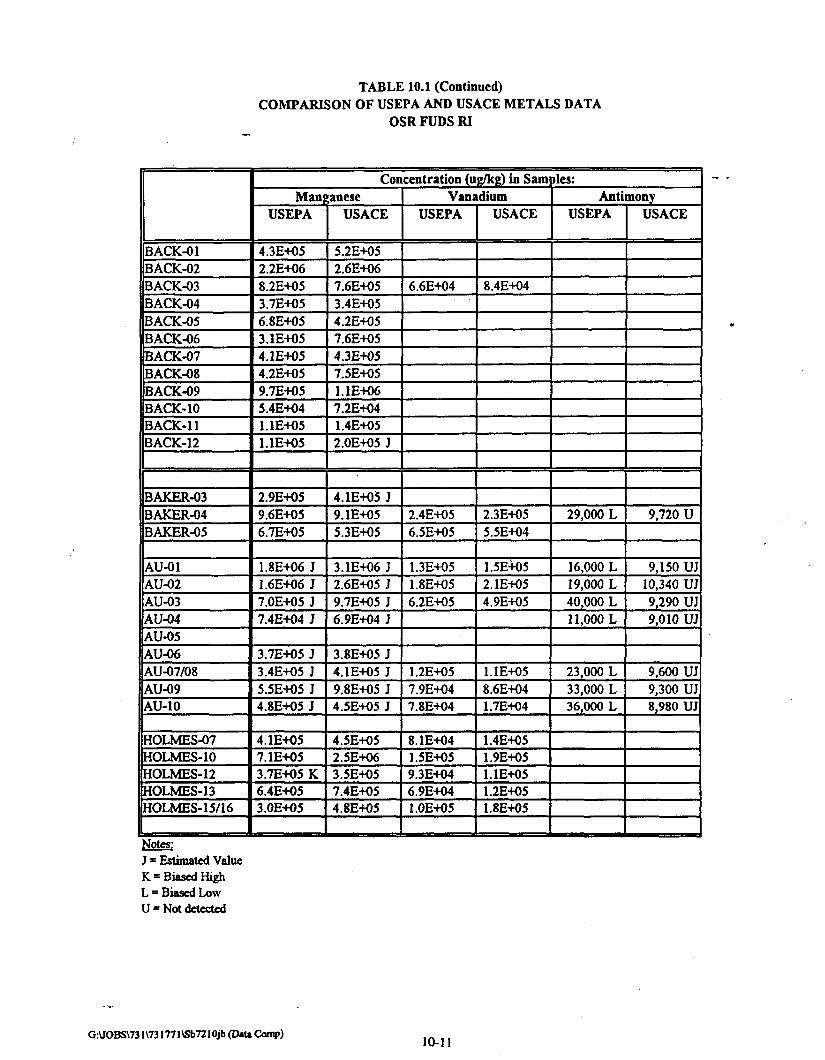
TABLE 10.1 (Continued)COMPARISON OF USEPA AND USACE METALS DATA
OSR FUDS RI
BACK-01BACK-02BACK-03BACK.-04BACK-05BACK-06BACK-07BACK-08BACK-09BACK-10BACK-11BACK-12
BAKER-03BAKER-04BAKER-05
AU-01AU-02AU-03AU-04AU-05AU-06AU-07/08AU-09AU-10
HOLMES-07HOLMES-10HOLMES-12HOLMES-13HOLMES-15/16
Concentration (ug/kg) in SamManganese
USEPA
4.3E-K)52.2E+068.2E+O53.7E+O56.8E+053.1E4O54.1E+O54.2E-KJ59.7E-KJ55.4E+O41.1E+O51.1E+05
2.9E+O59.6E+O56.7E+05
1.8E+O6 J1.6E+O6 J7.0E+O5 J7.4E+04 J
3.7E+O5 J3.4E+O5 J5.5E+O5 J4.8E-fO5 J
4.1E+O57.1E+O53.7E+O5 K6.4E+053.0E+O5
USACE
5.2E+O52.6E+067.6E+053.4E+O54.2E+057.6E+O54.3E+057.5E+O51.1E+067.2E-KJ41.4E+052.0E+O5 J
4.1E4O5 J9.1E+O55.3E+O5
3.1E+O6 J2.6E+05 J9.7E+05 J6.9E+04 J
3.8E4O5 J4.1E+O5 J9.8E+O5 J4.5E+05 J
4.5E+052.5E+O63.5E+057.4E4O54.8E4O5
VanadiumUSEPA
6.6E+04
2.4E+O56.5E-K)5
1.3E+O51.8E+O56.2E+O5
1.2E+O57.9E+047.8E+O4
8.1E+041.5E+O59.3E+046.9E-KM1.0E+O5
USACE
8.4E+04
2.3E+O55.5E+04
1.5E+052.1E+054.9E+05
1.1E+058.6E-H)41.7E+O4
1.4E-+O51.9E+O51.1E+051.2E+O51.8E+O5
pies:Antimony
USEPA
29,000 L
16,000 L19,000 L40,000 L11,000 L
23,000 L33,000 L36,000 L
USACE
9,720 U
9,150 UJ10,340 UJ9,290 UJ9,010 UJ
9,600 UJ9,300 UJ8,980 UJ
Notes:J = Estimated ValueK = Biased HighL = Biased LowU = Not detected
G:\JOBS\731\731771\Sb7210jb (D»U Comp)10-11

TABLE 10.1 (Continued)COMPARISON OF USEPA AND USACE METALS DATA
OSR FUDS RI
BACK-01BACK-02BACK-03BACK-04BACK-05BACK-06BACK-07BACK-08BACK-09BACK-10BACK-11BACK-12
BAKER-03BAKER-04BAKER-05
AU-01AU-02AU-03AU-04AU-05AU-06AU-07/08AU-09AU-10
HOLMES-07HOLMES-10HOLMES-12HOLMES-13HOLMES-15/16
Concentration (ug/kg) in SamThallium
USEPA USACENickel
USEPA
250,000
USACE
312,510
Dies:
MercuryUSEPA
20,00026,00017,00014,00018,000
USACE
120 J
120 UJ130 UJ110 J180 J
Notes:J = Estimated ValueK = Biased HighL = Biased LowU = Not detected
G:\KJBS\731\731771\Sb7210jb (ttaU Comp) 10-12

FINAL
10.5 LEWISITE RESIDUE
No.
22
Location in DocumentPP7
I3
Lines
2-4
Statement in Document
"Lewisite was found on glassware apparatus recovered during the removaloperations which also testifies to its long term viability."
Salient Issue:
Confirm that the sample contained Lewisite.
Response:
10.5.1 In the Remedial Investigation Report for the Operation Safe Removal Formerly
Used Defense Site, Section 3.3, Summary of Phase I Sampling, Analysis, and Removal
Activities, it is stated that "recovered glass fragments contained a residue of lewisite breakdown
products." The DCRA letter is in error by stating that lewisite was found on recovered
glassware. The Glassware was found in the area designated as POI 14. The initial report
identified arsenic, a possible lewisite breakdown product and ubiquitous naturally occurring
metal. However, confirmation sampling did not identify lewisite or lewisite unique breakdown
products. In addition, 64 soil samples, 4 water samples, 1 sediment sample and 1 groundwater
sample were collected at POI 14. All samples were analyzed for BNAs, metals, and explosives,
certain soil samples were analyzed for chemical agents and their breakdown products. No
chemical warfare agents or chemical warfare agent unique breakdown products were found.
K:\SHARED\731771VFINALRFnEb7322rp.doc 10-13

Section 11

FINAL
SECTION 11
AGENCIES & RESPONSIBILITIES
11.1 REVIEW PROCESS
11.1.1 In general, the production, review, and approval of all OSR FUDS plans and
reports was organized into two phases. The first phase was the production of the document and
internal review by various Army agencies. Upon incorporation of all Army comments, the
documents were then submitted to various non-Army agencies and personnel for review and
comment. Agencies/personnel to whom the documents were forwarded for review and comment
included the US Environmental Protection Agency Region HI, the District of Columbia Office of
Emergency Preparedness, and concerned Spring Valley residents and businesses (primarily the
Zone Captains). Upon receipt and incorporation of all modifications resulting from comments
received from these agencies/personnel, the reports were then submitted to USEPA Region HI
and the District of Columbia Office of Emergency Preparedness for final review.
11.1.2 In addition to the above, the review and approval process for the RI Report,
Proposed Plan, and Record of Decision added formal public comment periods and public
meetings as required under CERCLA. All documents in the Administrative Record were
available for review at the document repositories located at USACE in Baltimore and at the
District of Columbia public libraries (Palisades Branch and Tenley Branch). These documents
were then revised based on comments received during the public comment periods and public
meetings prior to finalization. Upon completion of these documents the ROD was signed by the
Department of the Army and USEPA Region in at a Pentagon ceremony attended by
representatives of the Army, USEPA Region HI, and the District of Columbia government.
KASHAREDV731771\FINALRFr\EB7318RP.DOC 11-1

FINAL
11.2 PUBLIC INVOLVEMENT
No.
4
Location in Document
PP
113
Lines
8-14
Statement in Document
"Although the American University site was identified by the Federal government in1985, stakeholders were not informed until the buried munitions story emerged in thepress in 1993. Indeed, it was not until 1994 that the Department of Defense recognizedthe need to refine its community involvement policy."
Salient Issue:
1) Determine when the property owners were informed. 2) Describe the extensive public
relations program performed by SVRO. .
Response:
11.2.1 CENAB's public affairs office developed a Public Involvement and Response
Plan to support OSR FUDS RI (See Appendix D). This plan was extensive and began in
January 1993 with a series of public meetings to inform residents of the follow on investigation,
goals, objectives, methods, and timelines. Public meetings were a staple of CENAB's public
involvement plan. During the lifecycle of the project more than 100 public meetings were
conducted to address every aspect of the project and numerous private meetings when residents
requested. The work site area was divided into 9 zones, and a Neighborhood Advisory Board
was established with a representative from each zone (a "Zone Captain") serving on the board.
During the project the board met with US ACE weekly and became the eyes and ears of the
community for the project. At each meeting, project information was discussed and board
members provided input and contributed to the decision making process. They had the
responsibility to keep their neighborhoods informed, which they did.
11.2.2 A Public Affairs Office was established at the work site, enabling residents to
visit anytime with questions or concerns. A monthly newsletter was ("The Heirs Response")
mailed to the entire Spring Valley neighborhood, keeping everyone up-to-date on the project.
When necessary, additional flyers were distributed with time-sensitive information. Information
was provided regularly to the media in the form of news releases and media days. The local
media covered the story for the entire project. Coverage was fair and balanced. All government
agencies involved with the project were invited to attend regular meetings to discuss the project.
Deskside briefings were provided to heads of District of Columbia and federal agencies in
addition to elected officials. Public repositories for project documents were established in two
local libraries. The Public Affairs Office established a presence in the community and
P:\FUDS\PROJECTS\DC09l801\RPT4.doe 11-2

FINAL
maintained a public dialogue throughout the entire project. A follow up survey testified to that.
Thus, it is reasonable to state that all OSR FUDS stakeholders were very well informed
regarding the status of all phases of the project.
Reference:
US ACE, 1993. Public Involvement and Response Plan (PIRP) for Sprins Valley Study Area.Washington, DC, November 12,1993 (2nd Revision). US ACE Baltimore District
K:\SHARED\731771\FINALRPT\EB7318RP.DOC 11-3

FINAL
11.3 EMERGENCY RESPONSE PROCEDURES
No.
12
Location in DocumentPP
3 2
Lines
1-6
Statement in Document _ .
"Subsequently, on April 2,1996, another live munition (incendiary whitephosphorous?) was found. The District of Columbia Department of Consumer andRegulatory Affairs, Environmental Regulation Administration (ERA) was notinformed of this event until April 19,1996. We have now been told that this shellwas found inside of a house."
Salient Issue:
Determine methods to ensure that CENAB is immediately contacted when any munitioris
are found at the OSR FUDS. _ _
Response:
Once the project was completed, the community was notified (by letter) to call 911 in the
event of a munition discovery. The 911 call notifies the police who in turn notify DC Office of
Emergency Preparedness (DCOEP) and the 149th EOD. Ordnance specialists from the 149th
EOD handle the safe removal of the munitions. DCOEP then notifies the CENAB's Emergency
Operations Center; who in turn notifies the chain of command within CENAB. It is DCOEP's
responsibility to notify other District of Columbia agencies if they deem it appropriate.
Appendix D is a copy of the notice to residents directing them to call 911 if the encounter a
suspicious object and a flow diagram after a 911 is made.
Reference:
None.
K:\SHARED\73177IVFlNALRPnEB7318RP.DOC 11-4

Section 12

FINAL
SECTION 12
CONCLUSIONS
No.
41
Location in Document
PP
1313
Lines
1-6
Statement in Document
"Because the remediation efforts at American University did not address all of the areasof concern reflected in the historical report, serious questions remain over the adequacyof the search for unexploded ordnance as well as the survey for residual contaminationfrom the toxic substances used in the research."
Salient Issue:
Determine if the RI adequately addressed all the potential environmental problems.
Response:
12.1 OVERALL
12.1.1 The investigation of the OSR FUDS Site was conducted in accordance with
DERP, 10 U.S.C. Sec. 2701-2707 and Section 104 of CERCLA, 42 U.S.C. 9601 et sefl. The
OSR FUDS investigation was properly conducted within the usual sequence of events outlined
by the CERCLA process described in USEPA Office of Solid Waste and Emergency Response
(OSWER) Directive 9355.3-01 (USEPA, 1988a). Public participation was encouraged through
the CENAB public affairs office developed and implemented Public Involvement and Response
Plan. All documents were approved by the appropriate parties.
The foundation of the OSR FUDS investigation was to focus initially on POIs identified
in the historical record as associated with CWM research, development, testing and evaluation.
12.1.2 The investigation was designed to locate:
• Caches of buried munitions associated with DoD activities at the OSR FUDS,
focusing on American University Experiment Station (AUES) activities; and
• Residual surficial soil contamination from CWM or CWM unique breakdown
products from static firings or persistence testing of CWM or residual contamination
from laboratory contaminants associated with CWM research and development at
AUES.
K:\SHAREDV73I771\FINALRPT\EB7336R1.DOC 12-1

FINAL
12.1.3 The scientific basis of the investigation was to investigate those areas of highest
probability of hazards and expand the area of investigation only if hazards were detected in these
high probability areas. These areas, termed Points of Interest (POIs), were identified in the
historical record as associated with CWM research, development, testing and evaluation. If
unexploded ordnance (UXO) or CWM was not located in those areas of documented use, the
likelihood of UXO or CWM in other areas of the OSR FUDS is remote.
12.1.4 The only munition cache was the initial find at 52nd Court which was associated
with an identified POI, POI 14. Additionally, after investigating over 1900 anomalies (including
pits, trenches, and single items) in 518 properties throughout the OSR FUDS, only four single
UXO items were found. Two were suspect "amnesty" rounds (turned in anonymously by local
residents). One was found in plain sight by the side of a road and the other was found near the
US ACE Spring Valley Resident Engineer's Office at the Interim Holding Area. The first was
considered a suspect CWM containing munition because it appeared to contain liquid when
handled (weight shifted). However, there were no static firing attachments and CWM was not
loaded into ballistically fired munitions at AUES. Although it was most likely filled with water
or other inert liquid it was sent to Pine Bluff Arsenal, Arkansas, for disposal. The other amnesty
round was sent to Letterkenny Army Depot, Pennsylvania. The third round was an unfuzed
mortar shell uncovered during the digging of a footer for a basement extension to a house. It
was removed from the area by the 57th EOD Unit at Ft. Belvoir, detonated, and determined from
detonation to be empty. The fourth was a spent Livens projectile partially filled with smoke
agent which was discovered by the OSR FUDS UXO investigation team. It was sent to a RCRA
permitted commercial facility in Sauget, Illinois, for incineration.
12.1.5 No CWM or CWM unique breakdown products were detected in over 260
environmental samples. Several naturally occurring metals which could also be associated with
CWM, and others which were not associated with CWM, were detected at levels above USEPA
Region III Risk Based Concentrations (RBCs) and above background. However, when
subjected to a risk assessment performed in accordance with the USEPA Risk Assessment
Guidelines for Superfund these were determined to require no further remedial action.
12.1.6 As a result of this current detailed review of the OSR FUDS investigation, the
USACE identified the possible presence of single UXO items and buried mustard agent in a
polymerized form (asphalt-like consistency) as potential residual hazards. Undisturbed, these
potential hazards pose no risk to the public and no further investigation beyond that for POI 24
(See 12.1.7) is warranted. However, to minimize the potential for injury in the event of a chance
discovery of a single UXO item or buried polymerized mustard agent, the Army will prepare a
K:\SHARED\731771\FINALRPT\EB7336R1.DOC 12-2

FINAL
fact sheet describing the UXO items and the characteristics of buried polymerized mustard agent
and notification procedures. This fact sheet should be provided to residents and contractors by
the District of Columbia Government whenever a digging permit is issued.
12.1.7 POI 24 was incorrectly located during the RI. As a result of the 1997 RI
evaluation, aerial and supporting photographs were reviewed by the USACE Topographical
Engineering Center (TEC). Based upon this review, the revised POI 24 location is on the
grounds of 4801 Glenbrook Drive instead of the American University property. This review
also identified this location as a possible mustard agent burial pit (see 8.8). The disposal
practice at the time was to place containers in a pit, break the container, spread chlorinated lime
over the mustard agent, and backfill the pit. Under these conditions, it is possible mustard agent
could exist in a polymerized form. Undisturbed, this potential hazard poses no risk to the
public. However, the following alternatives are available to address the long-term impacts of the
potential polymerized mustard or CWM related environmental contamination at POI 24.
• No action.
• Notify and coordinate with the public and take no action.
• Notify and coordinate with the public and initiate institutional controls (e.g. notify
the property owner, red tag any construction permits for this specific area).
• Notify and coordinate with the public and conduct additional geophysical
investigation and soil sampling for polymerized mustard or other CWM related
environmental contamination.
12.1.8 Based upon the new photographic interpretation, the Army recommends further
investigation of POI 24. This recommendation includes additional geophysical investigation
and soil sampling to determine if polymerized mustard or other CWM related environmental
contamination exist at POI 24.
12.2 REGULATORY FRAMEWORK
12.2.1 An orderly and usual sequence of events was performed during the OSR FUDS.
All applicable regulations were followed and the steps taken to perform this investigation were
reviewed by USEPA, DC Government, and affected citizens. The Record of Decision (ROD)
documenting "No Further Action Required" for OSR FUDS excluding Operational Unit-2 (OU-
2) (Spaulding and Captain Rankin Areas), was signed by the Army and EPA on June 2, 1995.
K:\SHARED\731771\FINALRTT\EB7336RI.DOC 12-3

FINAL
The draft Site Closure Plan and ROD for OU-2 documenting "No Further Action Required" has
been approved by USEPA Region III.
123 HISTORICAL FRAMEWORK
12.3.1 The OSR FUDS investigation benefited greatly from an abundant historical
record, including a 1918 aerial photograph of the test area. The historical record was thoroughly
reviewed and documented in The Historical Summary (USACE, 1994a). This allowed the
investigation to focus on those areas most likely to be impacted by the AUES research,
development, testing, and evaluation activities.
12.4 INVESTIGATION HYPOTHESIS
12.4.1 As stated above, the foundation of the OSR FUDS investigation was to focus
initially on those areas identified in the historical record associated with CWM research,
development, testing and evaluation to locate any buried caches of munitions or residual CWM
surficial soil contamination from static firings or persistence testing of CWM. If UXO or CWM
was not located in those areas of highest probability, the likelihood of UXO or CWM in other
areas of the OSR FUDS is remote. This is a scientifically defensible basis for the OSR FUDS
investigation.
12.5 POI IDENTIFICATION AND SELECTION PROCESS
12.5.1 POIs associated with CWM research, development, testing and evaluation were
identified and located by merging and interpreting 1918, 1927, 1991, and 1993 aerial
photographs utilizing various photogrammetric techniques by the USACE Topographic
Engineering Center. Additional POIs were identified from the historical record. Those POIs
identified as pits or trenches were geophysically investigated for munitions caches. Those POIs
associated with either CWM static firing testing or persistence testing were environmentally
sampled for CWM and CWM breakdown products.
12.6 UXO INVESTIGATION/REMOVAL PROGRAM
12.6.1 All POIs which were potential munitions burial pits were thoroughly investigated
using state-of-the-art instrumentation. One buried munitions cache was discovered, albeit by
construction activity prior to the beginning of the OSR FUDS investigation, at POI 14, a pit
K:\SHARED\731771\nNALRPTVEB7336Rl.DOC 12-4

FINAL
associated with the northern test trenches. Based upon the results of the OSR FUDS
investigation, the Army determined there are no remaining buried caches of munitions on the
OSR FUDS.
12.6.2 Since the initial 141 buried munitions were discovered, over 1900 anomalies
were investigated and only four intact munitions have been recovered at the OSR FUDS:
• Unfuzed 75 mm shell found near the original AUES area on the surface by a local
citizen. The round was assessed as a suspect chemical round and removed to Pine
Bluff Arsenal, Arkansas, for disposal.
• Spent Livens projectile partially filled with smoke agent excavated in Zone 9. It was
removed to a commercial RCRA incinerator in Sauget, Illinois, for incineration.
• Unfuzed 3" Stokes mortar round found in the vicinity of the SVRO, a probable
amnesty (i.e., discovered by a resident) round which was safed and transported to
Letterkenny Army Depot, Pennsylvania, for destruction.
• Unfuzed 3" Stokes mortar round next to a house foundation uncovered during
construction activities which was subsequently removed from the area and detonated.
The OE item was determined to be empty after it was destroyed.
12.6.3 Due to the extensive geophysical investigation, and the large amount of
development in the area, the probability of encountering even single UXO items is small.
12.7 ENVIRONMENTAL SAMPLING PROGRAM
12.7.1 The environmental sampling program focused on CWM and CWM unique
breakdown products at documented CWM testing areas. No CWM or CWM unique breakdown
products were detected in over 260 environmental samples. Other evidence supporting the lack
of remaining CWM or CWM unique breakdown products includes:
• These agents rapidly hydrolyze (degrade in water or moisture).
• There has been extensive development resulting in significant cut and fill of the area.
12.7.2 Several naturally occurring metals which could also be associated with CWM,
and others which were not associated with CWM, were detected at levels above RBCs and
K:\SHARED\73177I\FINALRPT\EB7M6RI.DOC 12-5

FINAL
above background. However, when subjected to a risk assessment performed in accordance with
the USEPA Risk Assessment Guidelines for Superfund these were determined to require no
further remedial action.
12.7.3 Since no CWM or CWM unique breakdown products were detected during the
extensive environmental investigation focused on those areas most likely to be contaminated, the
likelihood of encountering CWM or CWM unique breakdown products at OSR FUDS is remote.
12.7.4 POI 24 was incorrectly located during the RI. As a result of the current RI
evaluation, aerial and supporting photographs were reviewed by the USACE Topographical
Engineering Center (TEC). Based upon this review, the revised POI 24 location is on the
grounds of 4801 Glenbrook Drive instead of the American University property. This review
also identified this location as a possible mustard agent burial pit. Although this does not
present an imminent hazard to the public, the Army recommends additional investigation to
confirm and mitigate any potential future hazard.
12.8 RISK ASSESSMENT PROCESS
12.8.1 The risk assessment for the OSR FUDS was conducted in accordance with
USEPA guidance including the Risk Assessment Guidance for Superfund Human Health
Evaluation Manual (RAGS) (USEPA, 1989a) and supporting documents. Several naturally
occurring metals which could also be associated with CWM, and others which were not
associated with CWM, were determined to require no further remedial action by this risk
assessment process.
12.9 OTHER REPORTS
12.9.1 DCRA cited other reports and articles and suggested potential problems with the
OSR FUDS investigation. These reports and articles were reviewed for this evaluation of the
OSR FUDS investigations.
12.9.2 The Smithsonian article "The Soldiers Moved On. The War Moved On. The
Bombs Stayed." was used as evidence of the hazards associated with UXO and CWM. The
OSR FUDS Evaluation Report, Section 10.1, shows that a comparison between a WW I
battlefield and a research facility is not practical.
K:\SHARED\731771VFINALRPT\EB7336R1.DOC 12-6

FINAL
12.9.3 The Apex report was cited to show the OSR FUDS Investigation missed potential
arsenic and CWM contamination resulting in the exposure to contractors. However, the Apex
report, identified high levels of arsenic present with post AUES contaminants including Silvex
herbicide. The contaminant which acutely affected the contractors was most likely Silvex. In a
second incident, Apex reported contractors were affected by volatile organics or vehicle
emissions. Therefore, neither exposure was a result of AUES activities.
12.9.4 The Naval Security Station report was cited as evidence of widespread arsenic
contamination as a result of AUES testing activities. However, there was only one sample with
an elevated arsenic level. This was a background sample and does not validate widespread
arsenic contamination.
12.9.5 USEPA split sample data was cited as evidence that improper methods where
used in analyzing the soil and that potential contaminants were missed. The USACE data was
analyzed using USEPA analytical methods by an USACE Missouri River District approved
Laboratory. All data underwent rigorous data validation using USEPA validation protocols.
Any differences in split sample results is attributed to natural variability in soils, acceptable
analysis variability, and common interlaboratory variability. The review also found that the
SVOCs and PCBs found in the USEPA split samples were post AUES contaminants.
12.9.6 DCRA reported that lewisite residue was found on glassware. A review of the
OSR FUDS investigation found no evidence of lewisite residue found anywhere on the OSR
FUDS site.
12.10 AGENCIES AND RESPONSIBILITIES AND PUBLIC INVOLVEMENT
12.10.1 All documents were reviewed internally by appropriate Army agencies and then
submitted to various non-Army agencies and personnel for review and comment.
Agencies/personnel to whom the documents were forwarded for review and comment included
the US Environmental Protection Agency Region III, the District of Columbia Office of
Emergency Preparedness (the DC designated point of contact for the OSR FUDS investigation),
and concerned Spring Valley residents and businesses (primarily the Zone Captains). Upon
receipt and incorporation of all modifications resulting from comments received from these
agencies/personnel, the reports were then submitted to USEPA Region HI and the District of
Columbia Office of Emergency Preparedness for final review.
K:\SHARED\731771\FINALRPT\EB7M6RI.DOC 12-7
FINAL
12.10.2 All OSR FUDS stakeholders and regulatory agencies were kept very well
informed regarding the status of all phases of the project and had the opportunity to provide
comments.
12.11 POTENTIAL RESIDUAL HAZARDS
12.11.1 Potential Residual Hazards
12.11.1.1 The US ACE identified the following potential residual hazards:
12.11.1.2 Single UXO items. The OSR FUDS investigation focused on detecting large
caches of buried munitions. It was expanded to include detection of single UXO items on
properties in the proximity of POIs, however, single UXO items may remain on site.
12.11.1.3 Buried mustard agent which exists in a polymerized form. During this 1997
RI evaluation, further analysis of circa 1918 photos of AUES concluded 5 gallon
(approximately) glass or ceramic containers which could have contained mustard agent may
have been buried in a pit near the fenced perimeter of the AUES (see 8.8). The disposal practice
at the time was to place containers in a pit, break the container, spread chlorinated lime over the
mustard agent, and backfill the pit. Under these conditions, it is possible mustard agent could
exist in a polymerized form.
12.11.1.4 POI 24 was incorrectly located during the RI. As a result of this current RI
evaluation, aerial and supporting photographs were reviewed by the TEC. Based upon this
review, the revised POI 24 location is on the grounds of 4801 Glenbrook Drive instead of the
American University property. This review also identified this location as a possible mustard
agent burial pit (See 8.8).
12.11.2 Potential Risks
12.11.2.1 Undisturbed, these potential hazards pose no risk to the public. Possible
single UXO items will not spontaneously detonate. If polymerized mustard exists, it is not
releasing mustard vapors in its current form. To present a hazard it must contact the skin.
However, if disturbed through digging such as construction activity, these potential hazards may
be a risk to the public as described below:
12.11.2.2 Single UXO items. The probability of the public encountering a single round
is remote. During the RI, over 1,900 anomalies were investigated in 518 properties throughout
K:\SHAREDV731771\FINALRPTVEB7336RI.DOC 12-8
FINAL
the OSR FUDS with only four intact UXO single items found. None of the intact UXO single
items found were hazardous or posed any danger to the public prior to or upon discovery. All
were unfuzed. In addition, with the exception of the cache found at the identified POI 14, there
have been minimal UXO items uncovered, although there has been significant land development
in the OSR FUDS area since 1918.
12.11.2.3 Buried Polymerized Mustard Agent. The probability of the public coming in
contact with buried polymerized mustard agent is also remote. Besides POI 24, which the Army
has recommended for additional investigation, polymerized mustard would only be associated
with random locations where mustard may have been spilled and subsequently decontaminated.
Although mustard can exist in the polymer form for many tens of years, there is an equal
probability the agent completely degraded to much less toxic breakdown products. The
polymerized form has the consistency of asphalt and minimal vapor pressure. If it exists in the
polymer form, it is most likely in a relatively thin layer (from spilling from the broken
containers) and must be disturbed to become a hazard. This hazard would be a potential contact
hazard causing skin burns, but is not an inhalation hazard. In addition, the hazard would be very
localized, affecting only those who came in direct contact with the agent. It is not a splash or
vaporization hazard..
12.11.2.4 POI 24. The Army is recommending additional investigation to determine if
residual hazards, specifically mustard agent containers or polymerized mustard, exist at this
location.
12.11.3 Additional Investigation
12.11.3.1 Single UXO items. No additional investigation for single item UXO is
warranted. While the technology exists to locate UXO single items, in the Spring Valley urban
environment, the technology does not exist to distinguish a single UXO anomaly from urban
anomalies such as construction debris, ferrous rocks, etc. The OSR FUDS investigation focused
on those areas most likely to contain UXO caches and was expanded to detect single UXO items
within the POIs. Minimal UXO was discovered in these high probability areas. Expanding the
investigation to low probability areas is unlikely to uncover additional UXO single items.
12.11.3.2 Buried Polymerized Mustard Agent. With the exception of POI 24, no
additional investigation for buried polymerized mustard agent is warranted.
12.11.3.3 POI 24. Based upon the additional photo interpretation and the potential for
polymerized mustard to exist at POI 24, the Army evaluated the following alternatives to
K:\SHAREDY731771\FINALRPT\EB7336R1.DOC 12-9

FINAL
address the long-term impacts of the potential polymerized mustard or CWM related
environmental contamination at POI 24.
• No action.
• Notify and coordinate with the public and take no action.
• Notify and coordinate with the public and initiate institutional controls (e.g. notify
the property owner, red tag any construction permits for this specific area).
• Notify and coordinate with the public and conduct additional geophysical
investigation and soil sampling for polymerized mustard or other CWM related
environmental contamination.
12.11.4 Recommendations.
12.11.4.1 The Army recommends further investigation of POI 24. This
recommendation includes additional geophysical investigation and soil sampling to determine if
polymerized mustard or other CWM related environmental contamination exist at POI 24. The
Army will develop and implement a public involvement and response plan to address the issues
at POI 24.
12.11.4.2 With the possible exception of POI 24 where there is photographic evidence
mustard agent may have been disposed in a pit, the possibility of public contact with single
UXO items or buried polymerized mustard agent is extremely remote and will be associated
with digging activities. To minimize the potential for injury in the event of a chance discovery
of a single UXO item or buried polymerized mustard agent, the existing emergency response
procedures (911) should be reinforced and expanded. The Army will prepare a fact sheet
describing the UXO items (e.g., pictures of common AUES rounds) and the characteristics of
buried polymerized mustard agent (e.g., would be found in conjunction with ceramic or glass
fragments, has a garlic odor) and notification procedures. The fact sheet should be provided by
the D.C. government to:
12.11.4.2.1 Spring Valley OSR FUDS area residents and contractors whenever a
digging permit is issued.
12.11.4.2.2 Emergency response personnel.
12.11.4.2.3 All new Spring Valley OSR FUDS area residents at time of title transfer.
K:\SHAREm731771\FINALRPT\EB7336Rl.DOC 12-10

FINAL
12.11.4.2.4 All Spring Valley OSR FUDS area residents through an annual mailing.
12.11.4.2.5 Other citizens as determined appropriate by the DC Government.
12.12 CONCLUSIONS
12.12.1 The OSR FUDS investigation was properly conducted in accordance with
CERCLA and DERP. It focused on those areas with the highest probability for imminent
hazards or environmental contamination. The investigation found no imminent health or safety
hazards or environmental contamination associated with AUES ordnance testing or CWM or
CWM unique breakdown products. The Remedial Investigation Report, Site Closure Plan, and
Record of Decision were reviewed and approved by the public and appropriate government
agencies. The Record of Decision was signed June 2,1995.
12.12.2 POI 24 was incorrectly located during the RI. As a result of the current RI
evaluation, aerial and supporting photographs were reviewed by the TEC. Based upon this
review, the revised POI 24 location is on the grounds of 4801 Glenbrook Drive instead of the
American University property. This review also identified this location as a possible mustard
agent burial pit (see 8.8). Although this does not present an imminent hazard to the public, the
Army recommends additional investigation to confirm and mitigate any potential future hazard.
All the other POI were accurately located in the OSR FUDS RI Report and appropriately
investigated.
12.12.3 There is a possibility that UXO single items or buried polymerized mustard
agent remain on the site; however, there is no risk to the public if these remain undisturbed.
The possibility of public contact with single UXO items or buried polymerized mustard agent is
extremely remote and will be associated with digging activities. Additional investigation to
locate any potentially remaining UXO single items or buried polymerized mustard agent, with
the exception of POI 24, is not warranted. The risk to the public is remote and the investigation
is not technically feasible.
12.12.4 To minimize the potential for injury in the event of a chance discovery of a
single UXO item or buried polymerized mustard agent, the existing emergency response
procedures should be reinforced and expanded. The Army will prepare a fact sheet describing
the UXO items, the characteristics of buried polymerized mustard agent, and notification
procedures. This information should be provided by the D.C. Government to residents and
contractors whenever a digging permit is issued, to new Spring Valley area residents, annually
K:\SHARED\731771VFINALRPT\EB7336R1.DOC 12-11

FINAL
to Spring Valley area residents, to emergency response personnel, and to other citizens as
determined appropriate by the DC Government.
12.12.5 Consistent with its obligations under CERCLA and DERP, the Army remains
responsible for any additional response actions necessary in relation to buried munitions and
environmental contamination associated with prior Department of Defense (DoD) activities at
the OSR FUDS.
K:\SHARED\731771\FINALRPT\EB7M6R1.DOC 12-12

Section 13
FINAL
SECTION 13
REFERENCES
American University Archives, Letter dated September 24, 1971. Letter from Burton Logue tohis sister.
Apex Environmental, Inc., 1996. Final Report Conducted on President's Residence, 4835Glenbrook Road, Washington, DC. Apex Environmental, Inc.
Bancroft, Lt Col W.D, 1919. Bancroft, History of the Chemical Warfare Service in the UnitedStates, May 31, 1919, Research Collections. Office of History, Headquarters, US Army Corpsof Engineers, Fort Belvoir, VA.
Barth, D. S., B. J. Mason, T. H. Starks, and K. W. Brown, 1989. Soil Sampling QualityAssurance User's Guide. Las Vegas: US Environmental Protection Agency. EPA/600/8-89/046.
Bishop, E.C. Telephone conversation with Joseph H. Brewer, July 29,1997.
Carleton, 1918. Report of Field Experiments on Persistency of G-34. American UniversityExperiment Station.
DCRA, 1996. Final Report on World War I Poison Gas Production at the American UniversityExperiment Station. Government of the District of Columbia Department of Consumer andRegulatory Affairs Environmental Regulation Administration, Hazardous Waste Branch.
DCRA, 1997. Letter dated 30 January 1997 from Mr. Hampton Cross (DCRA) to Mr. ThomasVoltaggio (USEPA Region 111).
Department of Defense, 1997. Draft Proposed Military Range Rule. Department of Defense.32 CFR 178.
Engineering Science, June 24, 1993. Letter from Carl Drummond, Engineering Science toSpring Valley GIS File, Engineering Science. Subject: Rationale for Determining Horizontaland Vertical Datums, 1918 and 1991 Topography. Engineering Science Inc.
ERDEC, 1996. Analytical Results Report for Sample COE-L-6320-1. By Analytical ChemistryTeam, George L. Smith, SCBRD-ODC-O.
Gordon,. M. K., Sude, B. R., Oveibeck, R. A., 1994. Chemical Testing in the Great War: TheAmerican University Experiment Station. Washington History. Magazine of The HistoricalSociety of Washington DC. 6.
K:\SHAREDV731771\FINALRPTVEB73I8RP.DOC 13-1

FINAL
Haliburton NUS Environmental Corporation, 1993. Site Inspection for the Naval SecurityStation Washing ton DC Contract No. n62472-90-D-1298, Contract Task Order 0048.
Heller, Charles E, 1984. Chemical Warfare in World War I: The American Experience, t9i7-1918, Leavenworth Papers. 10. Combat Studies Institute.
Joe, P. and J. Hughart. 1997. Health Consultation: American University Experiment Station.Memorandum to Chief Medical Officer, Special Programs Activity, NCEH/CDC/HHS andDeputy Director, Office of Federal Programs, ATSDR/HHS. June 3, 1997. Agency for ToxicSubstances and Disease Registry.
Laboratory Report Undated. Undated Lab Report on Use ofL-1 (Lewisite) and G-34 (Mustard)as toxic smokes. American University Experiment Station.
Laboratory Report dated 26 June 1918. Report on Standard Methods on Gas ShellExperimentation. American University Experiment Station.
Laboratory reports dated 28 June 1918. Penetration of Fabric by Mustard I. AmericanUniversity Experiment Station.
Laboratory Report dated 15 July 1918. Lab Report on Penetrating Power ofL-1 - Mustard Oil.American University Experiment Station.
Laboratory Report dated 29 July 1918. Report Pharmacological and Pyrotechnic Sections,subject: Firing of Livens Projectile Filled with Cyanogen Chloride in a Trench, Richter et al,July 29,1918. American University Experiment Station.
Laboratory Report dated 5 August 1918. Report Pharmacological and Pyrotechnic Sections,subject: Firing of Livens Projectile Filled with Cyanogen Chloride in Front of a Double LineTrench, Richter et al, August 5, 1918. American University Experiment Station.
Laboratory Report dated 16 September 1918. BM Report XXIV Pyrotechnic & PharmacologicalSections, Richter, et al, Mustard Gas Field Test, September 16, 1918, p. 4. American UniversityExperiment Station.
Laboratory Report dated 23 September 1918. Report B. M. XXX-61, Firing a Liven's ProjectileLoaded with Cyanoge Chloride, Richter, et al, September 23, 1918. American UniversityExperiment Station.
Laboratory Report dated 19 October 1918. Report, Pyrotechnical Section, Richter, et al, GasShells - Firing a Liven's Projectile Loaded with Chloricrin, October 19, 1918, p. 3. AmericanUniversity Experiment Station.
Laboratory Report dated 21 November 1918. Report B. M. XXX-15, Pyrotechnic Section, GasShell Unit, Mustard Gas Field Test, November 21, 1918. American University ExperimentStation.
K:\SHAREDV731771\FINALRPT\EB7318RP.DOC 13-2

FINAL
Laboratory report dated December 1918. BM Report XXXVI-28, "Use of War Gases in Liven'sProjectors," Burrell, December 1918. American University Experiment Station.
Letter dated 24 June 1993. Letter from Carl Drummond, Engineering Science to Spring ValleyGIS File, Engineering Science. Subject: Rationale for Determining Horizontal and VerticalDatums, 1918 and 1991 Topography. Engineering Science Inc.
MacNaughton, M.G. and Brewer, J.H. "Environmental Chemistry and Fate of ChemicalWarfare Agents," Draft Final Report. January 17,1994.
Memorandum dated 10 February 1919. Memorandum from Ordnance Officer, ResearchDivision, American University Experiment Station, Subject: Shipping Orders. AmericanUniversity Experiment Station.
Memorandum dated 10 February 1919. Memorandum from Ordnance Officer, ResearchDivision, American University, Washington, DC. American University Experiment Station.
Memorandum dated 12 February 1919. Memorandum from Ordnance Office, Office of the Chiefof Field Service. American University Experiment Station.
Memorandum dated 1 March 1919. Memorandum from Office of Director of Chemical WarfareService to Chief, Research Division, Attention: Lt. Moulton. American University ExperimentStation.
Memorandum dated 28 May 1919. Memorandum from Chief of Construction Division toConstructing Quartermaster, Subject: Abandonment and Salvage of Camp Leach. Camp Leach.
Memorandum dated 7 June 1993. Memorandum for Record (Baker, Mark): "Firing andDetonation of Chemical Munitions at American University Experiment Station. 7 June 1993.USACE Baltimore District.
Smart, 1993. Memorandum For Record, Subject: Chemical Agents, Toxins, Smoke, Incendiary,and Detonator Materials Investigated at American University Experiment Station During WorldWar I. Historical Division, Corporate Information Office, Chemical Biological DefenseAgency).
Southwest Research Institute, 1994. Environmental Chemistry and Fate of Chemical WarfareAgents Prepared by Southwest Research Institute. Prepared for USACE Huntsville Division.
US Army, 1917. Field Service Pocket Book. Washington Government Printing Office, pg. 224.
US Army, 1959. Technical Services, Chemical Warfare Service: From Laboratory to Field.Office of Chief of Military History.
K:\SHAREtA731771VFINALRPT\EB73l8RP.DOC 13-3

FINAL
US Army, 1975. Military Chemistry and Chemical Compounds Field Manual., Department ofthe Army, 1975.
US Army, 1993. American University, Summary of USATHAMA Investigations Conducted In1986. US Army Toxic and Hazardous Materials Agency.
USACE, 1993. Public Involvement and Response Plan (PIRP) for Spring Valley Study Area.Washington, DC, November 12,1993 (2nd Revision). USACE Baltimore District
USACE, 1994a. A Brief History of the American University Experiment Station and US. NavyBomb Disposal School, American University. Office of History, Headquarters USACE.
USACE, 1994b. Quality Assurance Project Plan, Spring Valley Operation Safe RemovalProject, Washington, DC Prepared for US. Army Corps of Engineers, Huntsville Division andBaltimore District. Prepared by Engineering Science, Inc.
USACE, 1994c. Health and Safety Plan, Spring Valley Operation Safe Removal Project,Washington, DC Prepared for US. Army Corps of Engineers, Huntsville Division and BaltimoreDistrict. Prepared by Engineering Science, Inc.
USACE, 1994d. Field Sampling Plan for Remedial Investigation, Spring Valley OperationSafe Removal Project, Washington, DC Volume I: General Protocols. Prepared for US ArmyCorps of Engineers, Huntsville Division and Baltimore District. Prepared by ParsonsEngineering Science, Inc.
USACE, 1994e. Field Sampling Plan for Remedial Investigation, Spring Valley Operation SafeRemoval Project, Washington, DC Volume II: Site-Specific Plans. Prepared for US ArmyCorps of Engineers, Huntsville Division and Baltimore District. Prepared by ParsonsEngineering Science, Inc.
USACE, 1995a. Zone 2 Report, Operation Safe Removal Project, Washington DC February1995. Prepared for US Army Corps of Engineers, Huntsville Division and Baltimore District.Prepared by Parsons Engineering Science, Inc.
USACE, 1995b. Remedial Investigation Report for the Operation Safe Removal FormerlyUsed Defense Site, Washington DC Prepared for US Army Corps of Engineers, HuntsvilleDivision and Baltimore District. Prepared by Parsons Engineering Science, Inc.
USACE, 1995c. Defense Environmental Restoration Program for Department of Defense Sites,Ordnance and Explosive Waste, Chemical Warfare Materials, Archives Search Report,Findings, Catholic University. Prepared for US Army Corps of Engineers, Huntsville Division.Prepared by US Army Corps of Engineers, St. Louis District.
K:\SHARErX731771\FINALRPT\EB7318RP.DOC 13-4

FINAL
US ACE-TEC, 1994. The Use of Digital Photoerammetric Methods in Historical PhotoAnalysis. 1994 ASPRS/ACSM Annual Convention and Exposition, Technical Papers, Reno,Nevada April 25-28, Volume 1.
USEPA, 1986. Historical Photographic Analysis, American University Washington, DCPrepared for US ATHAMA. Prepared by USEPA EPIC.
USEPA, 1987. Data Quality Objectives for Remedial Response Activities. OSWER Directive9399.0-79.
USEPA, 1988a Guidance for Conducting Remedial Investigations and Feasibility Studiesunder CERCLA. OSWER Directive 9355.3-01.
USEPA, 1988b. Expanded Site Inspection Transitional Guidance. OSWER Directive 9345.1-02.
USEPA, 1988c. Interim Guidelines and Specifications for Preparing Quality AssuranceProject Plans. QAMS-005/80.
USEPA, 1989a. Risk Assessment Guidance for Superfund: Volume 1 - Human HealthEvaluation (Part A). Washington, DC: Office of Emergency and Remedial Response.EPA/540/1-89/002.
USEPA, 1989b. Guidance on Preparing Superfund Decision Documents: The Proposed Plan,The Record of Decision, Explanation of Significant Differences, The Record of DecisionAmendment, Interim Final. (EPA 540-G-89-007).
USEPA, 1996. Guidance for Data Quality Assessment: Practical Matters for Data Analysis,EPA QA/G-9, QA96 Version. EPA/600/R-96/084, July 1996.
USEPA, 1993b. Selecting Exposure Routes and Contaminants of Concern by Risk-BasedScreening. Region III, Office of Superfund Programs. EPA/903/R-93-001.
USEPA, 1994c. Risk-based Concentration Table. Region III, Technical Support Section.(April).
Weed Science Society of America, 1983. Herbicide Handbook, Weed Science Society ofAmerica, Fifth Edition.
K:\SHARED\73I771\nNALRPT\EB7W8RP.DOC 13-5

Appendix A
FINAL
APPENDIX A
DCRA COMMENT RESPONSE AND
USACE RESPONSE INDEX
O:\SHARED\731771\FINALRPT\EB7318RP.DOC

FINAL
APPENDIX ADCRA COMMENT RESPONSE AND USACE RESPONSE INDEX
OSR FUDS
No.1
2
3
4
5
6
7
7a
7b
8
9
10
Location in DCRADocument
Page
1
1
1
1
2
2
2 .
2
2
2
2
2
12
3
3
3
1
1
2
2
2
3
3
4
Lines1-6
1-2
6-8
8-14
2-4
7-10
3-7
3-7
3-7
1-7
8-10
1-7
Statement in Document".... this urgency did not permit the orderly and usual sequence ofoperations for remediation of formerly used military sites. The DraftProposed Military Range Rule (hereinafter, Range Rule), 32 CFR339 4/15/96 stresses the need to examine the entire range after arange assessment/accelerated response (RA/AR) is completed.""To our knowledge a total comprehensive environmental study wasnot done at the American University site."".... the Army lacked experience as well, because it was the first timethe Army had conducted an ordnance and chemical warfare removaloperation in a residential area.""Although the American University site was identified by theFederal government in 1985, stakeholders were not informed untilthe buried munitions story emerged in the press in 1993. Indeed, itwas not until 1994 that the Department of Defense recognized theneed to refine its community involvement policy.""In addition to the large variety of substances, large quantities [ofdangerous substances] also existed.""Many of these experiments involved releasing great quantities ofthese toxic substances into the air and on the soil to see the effectson animals placed at various distances from the release point.""Only a few of these chemicals have been tested for at the site, andthen only at isolated locations. No random grid sampling of soil andgroundwater was done. No survey has been conducted to determineif there are any adverse health effects to the residents of the area.""Only a few of these chemicals have been tested for at the site, andthen only at isolated locations. No random grid sampling of soil andgroundwater was done.No survey has been conducted to determine if there are any adversehealth effects to the residents of the area."".... the final 1995 report on the American University site indicatesthat only 53 points of interest there were scanned with metaldetectors in an effort to locate other buried munitions. During thislimited scanning 2,000 anomalies were found ... Of these anomalies,approximately 87 were excavated.""This failure to fully investigate all buried metal is magnified by theinadequacy of current detection equipment."".... since live chemical weapon munitions (CWM), as well as highexplosive shells, were found buried at the American University site,and many toxic substances were released into the environment, wefelt that a substantial research project was necessary in order todetermine the potential for residual contamination and munitions onthe site."
Locations in OSRFUDSRI
Evaluation ReportSection
3.1,3.2
*
8.1
7.4, 8.2
3.3,11.2
4.1
6.3.1
8.4.1
8.5, 8.6.2
9.1
5.2,7.5
7.3
5.2,8.1
G:\jobs\731X731771 \sb7209jc.doc A-l

FINAL
APPENDIX A(CONTINUED)
DCRA COMMENT RESPONSE AND USACE RESPONSE INDEXOSR FUDS
No.11
12
13
13a
13b
14
15
16
17
Location in DCRADocument
Page3
3
3
3
3
3
3
3
3
1f1
2
3
3
3
3
4
5
6
Lines
1-3
1-6
1-7
1-7
1-7
7-12
1-5
1-4
1-4
Statement in Document".... we became convinced of an immediate threat to the health andsafety of residents at the site.""Subsequently, on April 2,1996, another live munition (incendiarywhite phosphorous?) was found. The District of ColumbiaDepartment of Consumer and Regulatory Affairs, EnvironmentalRegulation Administration (ERA) was not informed of this eventuntil April 19,1996. We have now been told that this shell wasfound inside of a house.""Additionally, on June 10,1996, we were informed that a full glasschemical bottle with glass stopper had been unearthed along with theremains of several more, at the American University site. While weare awaiting a laboratory analysis, soil samples contained arseniclevels as high as 1200 parts per million, as well as other pollutants.To date, 40 cubic yards of contaminated soil have been removed.""Additionally, on June 10,1996, we were informed that a full glasschemical bottle with glass stopper had been unearthed along with theremains of several more, at the American University siteWhile we are awaiting a laboratory analysis, soil samples containedarsenic levels as high as 1200 parts per million, as well as otherpollutants. To date, 40 cubic yards of contaminated soil have beenremoved.""We were also informed that, 5 years ago, several workers wereovercome during excavation procedures at the same site andhospitalized for respiratory problems. We feel strongly that theseworkers may have been exposed to poison gas from these brokenbottles or a leaking munition disturbed during the excavationprocess.""It is our opinion that the remediation efforts did not address all ofthe areas of concern reflected in the Historical Report and RangeRule, and our own study, both with respect to the potential forcontamination and the likelihood of more unexploded munitions onthe site."".... the threat posed at the American University site requires thatevery part of the 600 acre site be surveyed with magnetometers andground penetrating radar to a depth of 10 feet, with all anomaliesintrusively investigated and cleared.""The entire site should have the soil at various depths sampled, aswell as the groundwater sampled for the toxic substances listedbelow. This should be a random grid sampling comparing theresults to off-site background levels."
Locations in OSRFUDSRI
Evaluation ReportSection
7.5
7.1,11.3
10.2.1
10.2.1
10.2.1
10.2.1
7.1,8.1
5.2,7.2,7.3, 7.5
5.1, 8.3, 8.5, 8.6.2,9.3
O:\jobs\731\73177 l\sb7209jc.doc A-2

FINAL
APPENDIX A(CONTINUED)
DCRA COMMENT RESPONSE AND USACE RESPONSE INDEXOSR FUDS
No.18
19
20
2122
23
24
25
26
27
28
29
Location in DCRADocument
Page3
4
4
57
7
9
9
9
9
10
10
%7
1
3
13
3
2
4
5
6
1
1
Lines1-3
1-5
3
12-4
4-6
1-8
1-5
3-5
1-5
1-4
10-12
Statement in Document".... a health survey of the residents should be conducted todetermine if there is any elevated incidence of any disease processes,related to the hazardous substances listed.""In our opinion, the immense quantity of gas there, the lack ofinformation indicating that any CWM were moved, the buried CWMalready found, the numerous-trenches providing convenient burial,compel the conclusion that more CWM still exist on the site.""There is mounting evidence that the American University Siteencompassed a massive production facility for poison gas in additionto its development and experimentation functions.""Specific Quantities and Types of Toxic Substances""Lewisite was found on glassware apparatus recovered during theremoval operations which also testifies to its long term viability.""The process for making large quantities of Lewisite was perfectedat American University.""Altogether, there were about 164 structures and earthworksidentified by the District and the Corps of Engineers. However, only53 Points of Interest have been intrusively investigated. Althoughsome of these points encompassed more than one structure, manyclearly have been omitted. Indeed, many of these structures havenot been located on any known maps, supporting ourrecommendation that the entire 600 acres needs to be examined(Appendix I)."".... there were 153 structures by war's end. Spills, dumping orburial of small quantities of toxic substances could have occurred atany of these structures, necessitating extensive soil and groundwatertesting."".... the second largest expenditure for a cylinder storage building,indicating a very large structure. This could have been an extensiveburial site.""Numerous documents detail tests of chemical shells at theAmerican University site. Some shells were attached to the top ofpoles or placed in the ground and fired electrically. Others werefired from mortars, designed to detonate on impact""We found trench maps and test reports from American Universityindicating that many Livens projectiles as well as smaller 75-millimeter artillery shells were tested with poison gas (AppendicesE, F, and G).""Unfortunately, the arsenic soil test data we have available is forareas away from many of the probable test sites."
Locations in OSRFUDSRI
Evaluation ReportSection
9.1
4.1,4.2,5.2:6.3.2
4.1
8.510.5.1
4.1.2
6.1
8.4.1,8.6.2
4.2
4.1.3
4.1.3
10.3
G:\jobs\731V73177 l\sb72O9jc.doc A-3

FINAL
APPENDIX A(CONTINUED)
DCRA COMMENT RESPONSE AND USACE RESPONSE INDEXOSR FUDS
No.30
31
32
33
34
35
36
37
38
39
40
Location in DCRADocument
Puge10
10
10
10
11
11
11
12
12
13
13
f1
2
3
4
1
2
2
1
3
0
1
Lines12-16
2-7
1-3
1-4
1-6
1-4
4-8
3-6
1-2
1-2
1-3
Statement in Document"Arsenic soil test data from the Naval Security Station, leeward fromAmerican University, reveals an elevated arsenic levelapproximately I foot underground, which could be compatible witha 75 year old deposition. Soil above and below this narrow bankshows very little arsenic (Appendix L).""Tremendous amounts of gas could be stored in even smallcylinders. Some of the shells experimented with at AmericanUniversity were also very large. For example, a 12 inch Navalchemical shell was developed. The 8 inch Livens projectile wasanother large shell, developed primarily to carry poison gas."".... one Point of Interest identified previously was the Old MustardField, a 500 foot diameter area covered repeatedly with mustardgas.""Some of the munitions previously found contain liquefied poisongas which is designed to vaporize when the shell ruptures on impactand likewise will vaporize if it rusts through.""This raises the level of potential devastation where old explosiveshells are buried together with chemical shells, as was the case atAmerican University, because a hypersensitive explosive filler coulddetonate rupturing many adjacent corroded chemical munitions,greatly increasing the amount of agent released.""Experience with the leftover gas shells found on the WWIEuropean battlefields conclusively demonstrates that the gas in theseshells remains viable, and mat the shells will corrode throughreleasing the gas.""A very definitive article on the hazards of remaining WWI gasmunitions is titled, 'The Soldiers Moved On. The War Moved On.The Bombs Stayed' by Donovan Webster, from the SmithsonianMagazine, February, 1994.""There are two potential sources for gas exposure at AmericanUniversity: (1) individual unexploded ordnance resulting from thedispersion testing; and (2) gas shells and cylinders, intentionallyburied, when the operation ended.""There were many shells fired during the dispersion testing whichmust have left many isolated dud or UXO rounds.""In all probability, there are numerous isolated dud rounds whichmust be located and cleared.""A very significant risk at the American University site is thelikelihood that many chemical munitions and cylinders were buriedwhen the project was abandoned at war's end."
Locations in OSRFUDSRI
Evaluation ReportSection
10.3
4.1.3
6.2
9.2
5.2,7.2
10.1
10.1
4.1.3,6.3.2
4.1.3
4.2
4.2
G :\Jobs\731 \73177 l\sb7209jc.doc

FINAL
APPENDIX A(CONTINUED)
DCRA COMMENT RESPONSE AND USACE RESPONSE INDEXOSRFUDS
No.41
42
43
44
45
46
47
48
Location in DCRADocument
Page13
13
14
14
15
16
16
16
3
3
1
3
1
2
4
5
Lines
1-6
6-13
1-3
1-3
1-10
1-7
1-8
1-2
Statement in Document"Because the remediation efforts at American University did notaddress all of the areas of concern reflected in the historical report,serious questions remain over the adequacy of the search forunexploded ordnance as well as the survey for residualcontamination from the toxic substances used in the research.""There are five areas of research findings which bear on the issue ofwhether of not a potential for more buried CW munitions exists: (1)burial occurred at other sites; (2) gases and shells were produced inextremely large quantities; (3) the entire site was shut down quicklyat wars end; (4) there were rumors of large scale burial operations;and (5) there is a lack of evidence that the leftover munitions wereturned over to other departments or moved elsewhere.""Second, as we have seen above, the production of chemical warfareagents was very large. The operation had 1200 chemists andengineers, and 700 support personnel.""Thus twelve hundred shells may have been sent to AmericanUniversity, shortly before its closing. From test reports and theshells recovered, we are only able to account for 107 of these,leaving 1093 unaccounted for gas shells in just the 75mm size(Appendix T). We were unable to locate any information on thenumber of Livens, Stokes or other gas shells sent to AmericanUniversity.""A letter dated November 8,1918, in response to concerns raised bythe Commissioners of the District of Columbia, stated,... supportsthe concept that sheik ordered earlier may not have been completelyused up.""The use of the word 'dispose' for supplies means burial to us.Whereas, 'salvage' for property means to sell or keep. Since theredid not appear to be much interest in surplus poison gas after thewar, a reason cited by chemical companies for declining the offer ofproduction contracts, it does not seem that existing stockpiles couldbe sold, leaving only the alternative of disposal.""Fourth, mere were rumors of large scale burial of munitions at thesite. In the Historical Report it states, The USATHAMA (US ArmyToxic and Hazardous Materials Agency) study incorporatedmaterials from American University and concluded that there was noevidence to confirm rumored large-scale burials of munitions. But itdid highlight two sites that would be likely candidate locations ifburial had occurred.""Fifth, the munitions apparently could not and were not turned overto the Ordnance Department."
Locations in OSRFUDSRI
Evaluation ReportSection
4.2,5.2, 7.2, 12
4.2
4.1
42
4.2
4.2
6.3.2
4.2
G:\jobs\731\73177 l\sb7209jc.doc A-5

FINAL
APPENDIX A(CONTINUED)
DCRA COMMENT RESPONSE AND USACE RESPONSE INDEXOSRFUDS
No.49
50
51
52
53
54
55
Location in DCRADocument
Page
17
17
17
1
1
1
2
K2
3
3
1
4
5
1
Lines
1-5
3-5
8-12
5-7
1-7
2-7
1-6,8-11
Statement in Document
"Not only is there no evidence that the 'enormous quantities' oftoxic substances and munitions known to have been there, weremoved, but these two memoranda seem to indicate that the chemicaland explosive munitions were not moved to the ordnancedepartment facilities at Aberdeen."
".... unexploded and buried chemical and high explosive ordnance iscertain to remain at the American University site.""Our view on the need for a complete site investigation with a studyof environmental contamination, health impacts, and a search of theentire area for individual UXO and buried stockpiles is alsoconfirmed by the proposed Range Rule."
Letter to USEPA from DCRA"It is the conclusion of the report that the initial investigation andremedial action performed by the U.S. Army Corps of Engineers wasnot adequately completed and the substantial additional action isrequired to protect the health and safety of residents in the area."Letter to USEPA from DCRA"....a large amount of chemical ordnance was manufactured at, or sentto, the site shortly before the site was rapidly decommissioned at the endof World War I. Documents suggest that leftover supplies were buried.However, the buried chemical ordnance recovered to date by the U.S.Army Corps of Engineers appears to be less than 5% of what webelieved to be present at the end of the war. With the lack of any hardevidence that this material was disposed of properly, we are concernedthat there are still large amounts of buried ordnance at the site."
Letter to USEPA from DCRARecently, a hot spot of 1200 ppm arsenic (background level isapproximately 3 ppm) was found at a private residence adjacent toAmerican University (report enclosed). We have learned that in 1992five (5) construction workers required medical treatment after beingovercome while digging the foundation for this residence. Theresidence is in close proximity to the site of an arsenic laboratory whichwas in operation during World War I."Letter to USEPA from DCRA"....we have also learned that EPA performed their own analysis ofsamples taken by the Army from locations at the Spring Valley site.The analysis results indicated contamination greater than the EPArecommended Risk-Based Concentration level for arsenic and otherhazardous substances. Both surface and above ground level air bursttesting of experimental chemical agents, many containing arsenic, wereperformed at the site Sample results may not indicate the presence ofarsenic if they were not within the downwind contamination areas ofthese air burst test sites, however. We are therefore concerned thatarsenic and other toxic materials may be present in high concentrationsthroughout Spring Valley and adjacent areas at rather shallow depths.
Locations in OSRFUDSRI
Evaluation ReportSection
4.2,6.3.2
7.5
3.1
8.1
4.2
10.2.1
6.1,10.4
G:\jobs\731\73177 l\sb7209jc.doc A-6

PRE-DECISIONAL: NOT TO BE RELEASED UNDER FOIA DRAFT
APPENDIX A(CONTINUED)
DCRA COMMENT RESPONSE AND USACE RESPONSE INDEXOSR FUDS
No.56
57
58
59
Location in DCRADocument
Page
2
2
2
2
12
3
3
4
Lines
3-7
1-2
2-3
1-5
Statement in Document
Letter to USEPA from DCRA"....neither a magnetometer (metal detector) sweep nor a grid soilsampling of the entire 600 acre site has been completed. Wheremagnetometer sweeps were done, only a small portion of the anomalies(indications of metallic debris) were excavated. The Army's ownresearch states that magnetometer sweeps for the identification ofsuspected anomalies without excavation is only 60% reliable."Letter to USEPA from DCRA"Many of the recommended procedures in the DoD's Proposed RangeRule. 32 CFR 178, including a Site Specific Response Evaluation, werenot completed.Letter to USEPA from DCRA"Neither a CERCLA Preliminary Assessment nor a RCRA FacilityAssessment was completed"Letter to USEPA from DCRAFinally, new technology, such as microgravity analysis, soil gas surveyswith color contour maps, and Pulsed Fast Neutron (PINS) Analysis arenow available. The Proposed Range Rule allows for reopening of arange when new technology would be helpful in clearance activities.Also, a deep seeking magnetometer with a data recording system andglobal positioning system (GPS), designed specifically for locating deepburial areas, could be used."
Locations in OSRFUDSRI
Evaluation Report
Section
7.5
•
3.1
3.2
3.1,7.3
\\PARESFAI01\DATA\SHAREDV731771\FINAUUTVSB7209JC.DOC A-7

Appendix B

FINAL
APPENDIX B
OSR FUDS RECORD OF DECISION AND
OU-2 APPROVAL LETTER
G:\SHARED\731771 \FINALRPT\EB7318RP.DOC

RECORD OF DECISION
FOR THE
OPERATION SAFE REMOVAL FORMERLY USED DEFENSE SITE
1.0 DECLARATION
1.1 Site Name and Location
Site Name: Operation Safe Removal Formerly Used Defense Site
Site Location: Washington, D.C.
1.2 Statement of Basis and Purpose
1.2.1 This decision document presents a determination that
no further action will be taken at the Operation Safe Removal
Formerly Used Defense Site (OSR FUDS) in Washington, D.C. This
decision document excludes the Captain Rankin Area of the OSR
FUDS, as it is still under investigation. This determination was
developed in accordance with the Comprehensive Environmental
Response, Compensation and Liability Act of 1980 (CERCLA) , as
amended by the Superfund Amendment and Reauthorization Act of 1986
(SARA), 42 USC Section 9601 et seq., and the National Contingency
Plan (NCP) 40 CFR Part 300. This no further action decision is
supported by documents contained in the administrative record.
The District of Columbia has concurred on the no further action
determination.

1.3 Declaration Statement
1.3.1 This no further action decision is based on the
baseline risk assessment conducted for the OSR FUDS, which
concluded that conditions at the OSR FUDS do not pose unacceptable
risks to human health and the environment. Therefore, no further
remedial action is necessary at the OSR FUDS, excluding the
Captain Rankin Area, to protect human health and the environment.
jewis D. Walker Date
Deputy for Environment, Safety, and Occupational
Health,
Occupational Health Office of the Assistant
Secretary of the Army,
U.S. Department of the Army

2.0 DECISION SUMMARY
2.1 Site Name, Location, and Description
2.1.1 The OSR FUDS is located in Northwest Washington, D.C.,
inclusive of the campus of American University. The OSR FUDS is
an urban, residential area consisting of approximately 616 acres.
The area is bounded by Dalecarlia Parkway from Westmoreland Circle
to Mill Creek to a 400 to 800 foot strip of land west of
Dalecarlia Parkway to Loughboro Road to Nebraska Avenue to Van
Ness Street to 43rd Street to Warren Street to 45th Street to Van
Ness Street to Massachusetts Avenue to Westmoreland Circle. This
area was divided into nine zones to aid in the investigation
effort. The OSR FUDS and the nine zones are shown in Figure 1.
2.1.2 The Captain Rankin Area of the OSR FUDS is comprised
of the shell pits located in Points of Interest (POIs) 21 and 23.
The final results of the investigation of the Captain Rankin Area
were not available for inclusion into the Final Remedial
Investigation (RI) Report; therefore, the Captain Rankin Area has
been excluded from this ROD. The Captain Rankin Area will be
addressed under a separate ROD upon completion of the
investigation.
2.1.3 The OSR FUDS has been developed as a residential
neighborhood with some commercial and retail centers located
primarily on Massachusetts Avenue. The OSR FUDS had a total
population of 13,203 in 1990. The site topography indicates that
surface water runoff is channeled into two intermittent streams
(Mill Creek and East Creek) . These streams are not used as
sources of potable water. Man-made storm sewers also channel
runoff over large portions of the site. Eventually all runoff at
the site flows into the Potomac River. The discharge points of
both Mill Creek and East Creek are approximately 1-mile downstream

NUMBER POINTS Of INTEREST
1 Circulor Trenches2 Possible Pil3 Small Crater Scan4 Possible Pit1 Possible Pit6 Pojubl* Torget or Test Sit*7 Possible Test Area8 Possible Target or Test Sit*9 Possible Firing or Observation Stalls10 Possible Targ«l or To t Sit*11. Scattered Cround Scors12. Possible Croded Ar*o13. Circulor Trenches14 PitIS. Cround Scor16 Chemical Persistency T*it Areo17. Possible Pit16 Smoll Crater Scors19 Old Mustord Held20 Cround Scor21. Shell Pit22 SheM Pil23 Shell Pit24. Probable Pit25 PossiM* Tr«neh*t26. Small Crottr Scors27. Probobl* Trench or (Men26. Probobl* Trench or Ditch29 Cround Scar30. Troining Trenches31. Training Trenches32 Training Trenches33. Troining Trenches34. Troining Trenches35 Troining Trenches36 Troining Trenches37 M.II Creeii30 BrOdKr Fi«ld/"O|Or Tolmon's Field39 Static Test Tire Veo40 Ohio HoN41 History Building42 Physiologieol Loborotory4 3 Cun Pit44 Chemicol Reseorcri Loborotory45 E>p*o»i*ei Laboratory46 Connister loborolory4 7 Bocteriologicol Loborotory46 Oisperoid Laboratory49 Phormocologicol LoborotorySO. Cun Pil51 Fire ond Flome loborotory52 Electrolytic Loborolory53 Boker Volley
NAUEO : OF INTEREST
POINT OF INTEREST
POINT OF INTEREST BOUNDARY
Tn>« mop * o i pr«por«d for us* ofor illustrative purposes only Tni
Sit« Th* scol*. accuracy, ond c<guorant*«d. No liobility is ossurrvoccuracv of tri« cioto coil«ct«d h«
in* US Army Corp* of Engineersmop H O I cr*ot*d using dotodot l not represent survey of the
mpleleneia of the doto is notd as to the sufficiency oreon
PARSONSENGINEERINGSCIENCE. INC.
*PPRO«IUATt SC*U
o too aoo
rtn
POINT OF INTEREST
OSR FUDS RlOPERATION SAFE REMOVAL
JOB NUMBERDOCUMENT NO.DAS SHEET

of the intake for the District of Columbia water system at Little
Falls Dam. Water is supplied to residents in the OSR FUDS area
through the District of Columbia water supply.
2.1.4 Groundwater flow in the piedmont rocks and saprolite
of the OSR FUDS is anticipated to follow the topographic gradient
toward the southwest and the Potomac River. Groundwater is not
used for public water supply at the OSR FUDS. No private,
domestic, or commercial wells have been observed at the site
during field activities.
2.1.5 A Record of Environmental Consideration for Remedial
Investigations at Spring Valley was completed on January 27, 1993.
2.2 Site History and Enforcement ActionB
2.2.1 The American University Experiment Station (AUES) was
used by the U.S. Army and Navy during World War I to investigate
the production of noxious gases, antidotes, and protective masks.
Initially operated by the Bureau of Mines, the AUES was
transferred to the U.S. Army and was operated by the U.S. Army
until 1918, when the experiment station was closed. The land
around the former AUES was subsequently developed into an urban
residential neighborhood located in Northwest Washington, D.C. In
January 1993, a contractor digging a utility trench uncovered
buried ordnance. The U.S. Army responded with Operation Safe
Removal.
2.2.2 Operation Safe Removal consisted of two phases. Phase
I was the immediate emergency response after the discovery of
buried ordnance in January 1993. Phase I of Operation Safe
Removal began on January 5, 1993 and ended on February 2, 1993.
The ordnance items included 141 intact munitions, assorted
ordnance-related debris, and laboratory material. The buried
ordnance items were removed by the U.S. Army. Forty-three of the

intact munitions recovered were deemed suspect chemical munitions
and subjected-to further on-site qualitative analysis. This
analysis confirmed that the items were chemical munitions. Nine
of the suspect chemical ordnance items were subjected to
quantitative off-site analyses. The results of these analyses
revealed that one munition contained mustard agent, five contained
aqueous salt solutions, two contained fuming sulfuric acid, and
one contained gun cotton. Soil, surface water, and groundwater
samples were collected during the removal of the ordnance items.
The analysis of the soil samples collected from the excavated area,
and soil, surface water, and groundwater samples collected from
the vicinity of the excavated area indicated that no residual
contamination was present as a result of buried munitions.
2.2.3 On January 21, 1993, the Findings and Determination of
Eligibility was approved establishing the OSR FUDS. This study
determined that 509 acres were eligible, with an additional 107
acres subsequently added as an addendum, as part of the OSR FUDS.
An inventory project report conducted by the U.S. Army concluded
that Chemical Warfare Material (CWM) hazards could potentially be
present at the site. Consequently, the Army determined that it
was necessary to conduct a remedial investigation (RI) to
determine if Ordnance and Explosive Waste (OEW) or CWM were
actually present at the site and posed potential adverse health
risks. The RI was performed during Phase II of Operation Safe
Removal.
2.2.4 Phase II of the RI began immediately after Phase I on
3 February 1993. Phase II included the historical records search,
geophysical survey, intrusive studies, non-time critical and time
critical removal actions, environmental sampling, and risk
assessment necessary to determine the existence and extent of any
OEW and/or OEW- or CWM-related environmental contamination within
the OSR FUDS as a result of Department of Defense (DoD) activities
during World War I. These activities and findings, excluding the

Captain Rankin Area, which is still under investigation, are
summarized in the RI Report.
2.3 Highlights of Community Participation
2.3.1 The RI Report was released to the. public on 21 March
1995. This document was made available to the public in both the
administrative record and in information repositories maintained
at the following locations:
• Spring Valley Resident Office;
• Washington, D.C. Public Library - Tenley
Branch; and
• Washington, D.C. Public Library -
Palisades Branch.
The notice of the availability of this document was published in
the Washington Post and Washington Times on 21 March 1995.
2.3.2 To provide the community with reasonable opportunity
to submit written and oral comments on the results of the RI for
the OSR FUDS, the Army established a public comment period from 21
March 1995 through 30 April 1995. A public meeting was held on 23
March 1995 to present the results of the RI and to answer
questions and receive comments. A response to the comments
received during this period is included in the Responsiveness
Summary, which is part of t̂ his Record of Decision (ROD) . This
decision document presents the determination that no further
remedial action is necessary for the OSR FUDS in Washington, D.C. ,
is consistent with CERCLA, as amended by SARA and, to the extent
practicable, the National Contingency Plan. The decision for this
site is based on the administrative record.

2.4 Scope and Role of OSR PUDS Response Action
2.4.1 Th"e RI of the OSR FUDS investigated the site for the
presence of CEW and CWM at the site. This ROD is the final action
for addressing the potential presence of OEW and CWM at the OSR
FUDS, excluding the Captain Rankin Area. The U.S. Army has
concluded that there are no OEW or CWM hazards remaining at the
OSR FUDS that warrant further remedial action. Therefore, no
further action is required for the OSR FUDS. This ROD serves to
document this no further action decision.
2.5 Site Characteristics
2.5.1 The RI of the OSR FUDS focused on areas most likely to
contain OEW or to be contaminated by OEW, CWM, or their breakdown
products. The RI was aided by the historical record of World War
I chemical agent research, development, and testing activities of
AUES, including a 1918 aerial photograph of AUES. Geophysical
surveys of areas of interest four times greater than the size of
points of interest (POIs) along with 10 percent of the remaining
area, and follow up intrusive investigations of suspect anomalies,
were conducted to find any buried ordnance remaining at the OSR
FUDS from the activities at AUES. The soil investigation focused
on sampling for chemical agents, associated breakdown products,
and OEW residue results most likely to be present at points of
interest throughout the OSR FUDS. The following subsections
summarize the findings of the RI Report.
2.5.1 Ordnance
2.5.1.1 Since the initial discovery of 141 buried munitions,
three intact munitions have been recovered at the OSR FUDS. One
was a 75 millimeter (mm) shell found in October 1993 near the
original AUES area on the surface. This round was assessed as a
suspect chemical round. The second was a Livens projectile
partially filled with smoke agent which was excavated under a Time
B

Critical Removal Action in May 1994. The third was an unfuzed 3-
inch Stokes Mortar found near the Spring Valley Resident Office
(SVRO) in November 1994, which was apparently an amnesty find left
by an unknown individual.
2.5.1.2 Spent OEW discovered within the OSR FUDS included
ten 75 mm expended projectiles and numerous fragments within POIs
10/11 and 3 9 and Zone 9; fuzes, fuze components, and shell
fragments in the area of POIs 21/22/23 and 25; and the empty nose
cone of a World War I incendiary drop bomb in the American
University soccer field (Figure 1).
2.5.2 Environmental Samples
2.5.2.1 No chemical agents, CWM-unique breakdown products,
explosives, or explosives breakdown products were found in soil,
groundwater, surface water, or sediment samples collected from the
OSR FUDS. However, several metals were detected in samples
collected from all of these environmental matrices. These
analytical results were initially compared to U.S. Environmental
Protection Agency (USEPA) Region III risk based concentrations
(RBCs) for the protection of human health. Chemicals present at
concentrations exceeding screening RBCs were then statistically
compared to background, i.e., naturally-occurring concentrations.
If the concentration of a chemical exceeded both RBCs and
background, the chemical was considered a chemical of potential
concern. All chemicals of potential concern were subsequently
included in a quantitative risk assessment performed for the OSR
FUDS.
2.5.2.2 Results of soil sampling at four POIs in Zones 4 and
5 indicated the presence of metals at concentrations that exceeded
RBCs and background concentrations (Table 1). These metals were
considered chemicals of potential concern and were evaluated using
a quantitative risk assessment in accordance with USEPA's Risk

Assessment Guidance for Superfund. This risk assessment indicated
f.hat no health hazard exists due to the presence of these metals.
2.5.2.3 Section 1.8 of the RI Report notes that the results
of the investigation of the Captain Rankin Area were not available
at the time of the final RI Report. Therefore, the Captain Rankin
Area has been excluded from this ROD. The Captain Rankin Area
will be addressed under a separate ROD upon completion of the
investigation.
TABLE 1
METALS SUBJECTED TO QUANTITATIVE RISK ASSESSMENT
OSR FUDS ROD
POI M e t a l
21/22/23 aluminum, beryllium, manganese, nickel, thallium, and vanadium
25 aluminum, selenium, thallium, and vanadium
American University aluminum, beryllium, cadmium, nickel, and vanadium
livens Excavation, in 2one 9 beryllium, cadmium, and zinc
1 0

2 . 6 Summary of Site Risks
2.6.1 Methodology and Assumptions
2.6.1.1 Detected chemicals were screened in the risk
assessment with respect to background metal concentrations, the
presence of essential nutrients, and USEPA Region III RBCs.
Chemicals having concentrations that exceeded RBCs and that could
not be conclusively attributed to background or other sources were
retained as chemicals of potential concern.
2.6.1.2 Residents and construction workers were evaluated
for exposure to chemicals in soil. Exposure pathways for the
residential scenario included:
• Ingestion of surface soil;
• Dermal contact with surface soil while
gardening; and• Ingestion of homegrown vegetables.
Risks from ingestion of surface soil were addressed
quantitatively, while risks from ingestion of homegrown vegetables
and dermal contact were addressed qualitatively. Exposure
pathways evaluated for the construction worker scenario included:
• Ingestion of surface and subsurface
soil ,•
• Dermal contact with surface and
subsurface soil; and
• Particulate inhalation.
Risks from particulate inhalation and ingestion of surface and
subsurface soil were addressed quantitatively. Dermal contact and
ingestion of homegrown vegetables were addressed qualitatively.
li

2.6.1.3 Chen-.ical intake was combined with toxicity
information to calculate risks. USEPA-generated slope factors and
reference do'ses were used to evaluate carcinogens and
noncarcinogens, respectively. For carcinogens, risks were
estimated as the incremental probability of an individual
developing cancer over a lifetime as a result of exposure to the
potential carcinogen. The USEPA-acceptable risk range is from one
in ten thousand (10"*) to one in one million (10^) . For
noncarcinogens, potential health threats are evaluated by
comparing an estimated exposure level over a given period to a
reference level (the RfD) below which it is unlikely that even
sensitive individuals will experience adverse health effects.
This ratio is expressed as a hazard index; if the calculated
hazard index is below one, than adverse effects are not expected.
2.6.2 Soil Sampling Results
2.6.2.1 Chemicals of potential concern were identified at
POIs 21/22/23 and POI 25 in Zone 4; at American University in Zone
5; and at the LTC Bancroft Area in Zone 9. In Zone 4, the
following chemicals of potential concern were identified and
evaluated: aluminum, beryllium, manganese, nickel, selenium,
thallium, and vanadium. Results of the risk assessment for Zone
4 indicated that no further remedial actions are necessary due to
the presence of these metals. In Zone 5, the following chemicals
of potential concern were identified and evaluated: aluminum,
beryllium, cadmium, nickel, and vanadium. Results of the risk
assessment for Zone 5 indicated that no further remedial actions
are necessary due to the presence of these metals. In Zone 9, the
following chemicals of potential concern were identified and
evaluated: beryllium, cadmium, and zinc. Results of the risk
assessment for Zone 9 indicated that no further remedial actions
are necessary due to the presence of these metals.
12

2.7 Conclusion
2.7.1 Based on the RI, there are no risks posed by hazardous
substances that exceed acceptable risk levels for human health or
the environment. Consequently, no further action is needed at the
OSR FUDS.
2.8 Explanation of Significant Changes
2.8.1 The RI Report for the OSR FUDS site was released for
public comment on 21 March 1995. The RI Report identified no
further' action as the remedy for the OSR FUDS. The U.S. Army
reviewed all written and verbal comments submitted during the
public comment period. Upon review of the these comments, it was
determined that no significant changes to the no further action
determination proposed in the RI Report, were necessary.
3.0 RESPONSIVENESS SUMMARY
3 .1 Community Preferences
3.1.1 At the time of the public comment period, the Army
proposed that "no further action" was necessary for the OSR FUDS
in Washington, D.C. Based on the comments received during the
public comment period, the public supports this "no further
action" proposal for the OSR FUDS.
13

3•2 Background on Community Involvement
3.2.1 Community interest in the OSR FUDS began when buried
ordnance was discovered in January 1993 at 52nd Court, N.W. Upon
definition of the boundaries of the OSR FUDS, the Army divided the
FUDS into nine zones to aid subsequent investigative efforts.
Because of the large number of people potentially impacted by the
site, the Army then solicited members of the local community to
become "Zone Captains" to facilitate communication between the
Army and the residents of each of the nine zones. Briefings on
the progress of the investigation was provided at weekly Zone
Captain meetings held at the SVRO. Zone Captains in turn conveyed
the information obtained during these meetings to the residents of
their respective zones.
3.3 Integration of Comments
3.3.1 Comments raised during the OSR FUDS public comment
period on the Remedial Investigation Report are summarized briefly
below. Only significant comments are recounted below; other
comments pertaining to minor inaccuracies or verbiage changes are
not included. The comment period was held from March 21, 1995 to
April 30, 1995.
1. W.C. and A.N. Miller Companies stated support for the
selection of the no further action strategy for the OSR
FUDS, however, they felt that language throughout the
report should be amended to more strongly reflect the
rationale for the Army's conclusion that no further
action is required in the OSR FUDS.
Army Response: It is stated throughout the risk
assessment that the calculated risks are within USEPA's
acceptable risk range. Thus, the statement that the
results of the risk assessment do not support a need for
further remedial action at the OSR FUDS is both accurate
and appropriate.
14

W.C. and A.N. Miller Companies expressed concern that
several assumptions made in the risk assessment were
unduly conservative and resulted in an overstatement of
actual risk. However, W.C. and A.N. Miller Companies
concluded by stating that since the Army has concluded
that no further action is required, it is pointless to
revise the risk assessment using less conservative
assumptions because the ultimate conclusion would be the
same. Finally, W.C. and A.N. Miller Companies stated
that, in other regards, the risk assessment is fully
supported by sound science.
Army Response: The risk assessment for the OSR FUDS was
conducted in accordance with USEPA's Risk Assessment
Guidance for Superfund (RAGS). The conservative
assumptions that were made were in accordance with RAGS
and with specific guidance received from USEPA Region
III.
W.C. and A.N. Miller Companies.states that the summary
in paragraph 3.2.3.2 of the RI report of the three
documents that comprise the 1986 Army report
"understates the conclusions therein that other
munitions could be buried in the area." W.C. and A.N.
Miller Companies continue by contending that "It is
disingenuous, if not deliberately misleading, to state
that 'None of the documents point conclusively to any
large scale ordnance burials' and that 'the possibility
of buried ordnance was not 'completely discounted.'
Moreover, the RI does not explain that the 1986 report
was never disclosed to the public prior to the discovery
of munitions on 52nd Court in January of 1993."
Army Response: The statements made in the RI report and
called out by W.C. and A.N. Miller Companies are an
accurate summary of the 1986 U.S. Army Toxic and
Hazardous Materials Agency (USATHAMA) report. In his 2 9
October 1986 Memorandum for Record summarizing the Camp
15

American University historical search, Mr. J.W.
Williams, USATHAMA Historian, makes the following
statements:
• "The. sole source that says munitions were
buried is historically suspect because of
when written, the contexts in which
statements appear, the nature of the source,
and inferences from comparisons with other
sources."
• "If any materials were buried, they were
probably small quantities of laboratory or
experimental materials. All sources we found
were inconsistent with the notion of
substantial quantities of any munitions or
the components for munitions existing at
[American University]".
• "We could not disprove the burial of some
materials on or near Camp American
University, and subsurface ordnance could
still exist from military uses of [American
University]".
Therefore, based on the above information, the
statements cited by W.C. and A.N. Miller Companies in
paragraph 3.2.3.2 of the RI report are deemed by the
Army to be neither "disingenuous" nor "deliberately
misleading", but instead to be an accurate summary of
the major conclusions of the USATHAMA report. Finally,
the RI Report has been amended to state that the 1986
USATHAMA report was not disclosed to the public until
discovery of the buried munitions in 1993.
4. W.C. and A.N. Miller Companies concluded their comments
by stating that it "supports the Army's conclusion that
no risk to human health, safety or the environment
exists in the OSR FUDS, and that no further action is
therefore warranted.'
16

Army Response: No response required.
3.4 Remaining Concerns _.
There were no issues raised during that public comment period
that have not been addressed by the Army.
17

UNITED STATES ENVIRONMENTAL PROTECTION AGENCYREGION 111
841 Chestnut Building" Philadelphia, Pennsylvania 19107-4431
REPLY TO ATTENTION OF«
F«dM-»l Facilities S m h (SW60)
VIA ELECTRONIC MAILFEDERAL XZPRXSE
Juna 2, 1997
U.S. Army Corps of EngineersBaltimore DistrictPrograms £ Project Management Division10 S. Howard StreetBaltimore. MD 21203-1715
Attn: Gerry Pollis. Chief (CEKAB-PP-E)Environmental Management Branch
Re: Final Remedial Investigation ("RI") ReportSpaulding and Captain Rankin AreasAmerican University Experiment stationFormerly Used Defense Site ("Spring Valley")Washington, D.C.
Dear Mr. Pollis:
Please reference separate correspondence from the U.S. EnvironmentalProtection Agency Region III ("EPA Region III" or "Agency") to the U.S. ArmyCorps of Engineers ("COE") Baltimore District dated February 12, 1996, May 24,1996 and August 15, 1996 regarding the draft RI report for the Spaulding andCaptain Rankin Areas portion of the Spring Valley Site, which is otherwisedesignated as Operable Unit Two ("OU-2"). Also reference February 10, 1997correspondence from Parsons Engineering Science, inc. ("Parsons ES") to SPARegion III that transmitted the final RI report (Volume I and Volume II) , datedJune 1S96, as well as the responses to comments on the draft RI report, for OU-2as attachments. This correspondence also transmitted the draft Site Closure Planand draft Record of Decision ("ROD") for OU-2. EPA Region III received theParsons ES correspondence via federal express en February 12, 1997. The Agencynotes that we had previously received the draft Site Closure Plan and draft RCDfor OU-2 as an enclosure to December 13, 1996 correspondence from COE BaltimoreDistrict.
As promised during the May 23, 1997 meeting at COE Baltimore DistrictOffices, EPA Region III is providing comments on the final RI report for OU-2.By way of this letter, EPA Region III informs you that, with one very minorexception, COE has satisfactorily addressed all substantive written and verbalcomments on the draft RI report for OU-2. As stated in EPA Region Ill's August15, 1996 correspondence to COE Baltimore District, the Agency discovered certainminor typographical errors in the original data validation report prepared by ourCentral Regional Laboratory with respect to an analytical data summary generatedon behalf of Parsons ES by Battelle (i.e., incorrect site name on the datasummary form). A revised Quality Assurance Review Memorandum, dated June 17,1996, was included as an attachment to the August 15th correspondence. A reviewof the final RI report. Volume II, Appendix C-4 indicates that the original datasummary form has not been replaced. Although this omission does not affect EPARegion Ill's conclusions regarding data usability, it is suggested that COEBaltimore District instruct Parsons ES to insert the revised data summary form,which been provided AS an attachment to this letter.

4109622318 CENPB-EN-H
In terms of COE-generated data used in the quantitative risk assessment,EPA Region III concurs with the recommendation in the final RI that no furtheraction is necessary at OU-2. EPA Region XII offers no substantive commentsregarding the draft Site Closure Plan and draft ROD for OU-2 except to note thatclose-out of the entire Spring Valley site should properly be deferred untilsatisfactory resolution of environmental concerns recently raised by the Districtof Columbia. - •
On a related matter, this letter also serves to document EPA Region Ill'sreceipt of graphics file that the Agency understands contains a detailed planview map showing properties/lots at the Spring Valley site (i.e., denoted as"Plate AM and entitled "Lots and Properties, OSR FUDS RI, Operation Safe Removal"and included in Appendix C to the final RI report for OU-1, dated June 1, 1995) .Consistent with discussions during the May 23rd meeting, it is suggested thatthis information be used to create plan view map overlays, thereby allowing usto more clearly show the spatial relationship among properties/lots, identifiedpoints of interest, areas of chemical contamination and other areas of potentialenvironmental concern. This approach should enable both EPA Region III and COSBaltimore District to better respond to the District of Columbia's environmentalconcerns.
As you know, I will be on vacation from June 3, 1997 to June 23, 1997,inclusive, and will be unavailable until my return to the office on June 24,1997. In my absence, you may direct any questions to my supervisor, HenrySokolowski, who may be reached at (215) 566-3348. Please be assured that yourcontinued cooperation is greatly appreciated.
cere
Drew LauschRemedial Project Manager
Attachment
cc w/o attachment:
Hank Sokolowski (EPA)Linda Watson (EPA)Brian Nishitani (EPA)Bill Hudson (EPA)Tern Stukas (ATSDR)Jim Sweeney (District of Columbia)

Appendix C

FINAL
APPENDIX C
CITED LOCATION CROSS REFERENCE
G:\SHARED\731771VFIN ALRJT\EB7318RPDOC

FINAL
APPENDIX C
CITED LOCATION CROSS REFERENCE
ZONE
1
2
3
POI
13
14
15
16
1
2
3
4
5
6
7
8
9
10
11
12
38
39
PossibleLinear
Depression
19
29
IDENTIFIEDPOI NAME PROPERTY
Circular Trenches 52d Court
Pit 52d Court
Ground Scar
Chemical PersistencyTest Area
5010 Sedgewick Street
Circular Trenches
Possible Pit
Small Crater Scars
Possible Pit
Possible Pit
Possible Target or TestSite
Possible Test Area
Possible Target or TestArea
Possible Firing orObservation Stalls
Possible Target or TestSite
Scattered Ground Scars
Possible Graded Area
Bradley Field/MajTolman's
Static Test Fire Area
Old Mustard Field
Ground Scar
COMMENTS
Identified in EPICReport
Phase I initial find
April 2, 1996 UXO find
G:\SHARED\731771VFIN ALRPT\EB7318RP.DOC C-l

FINAL
ZONE
4
5
POI
East Creek
17
18
20
21
22
23
25
26
53
East Creek
AmericanUniversity
27
28
40
41
42
43
44
45
46
47
48
APPENDIX C
CITED LOCATION CROSS REFERENCE
(Continued)
IDENTIFIEDPOI NAME PROPERTY
Possible Pit
Small Crater Scars
Ground Scar
Shell Pit (Concrete Bunker)
Shell Pit (Concrete Bunker)
Shell Pit (Concrete Bunker)
Possible Trenches
Small Crater Scars
Baker Valley
Probable Trench or Ditch
Probable Trench or Ditch
Ohio Hall
History Building
Physiological Laboratory
Gun Pit
Chemical ResearchLaboratory
Explosives Laboratory
Canister Laboratory4
Bacteriological Laboratory
Dispersoid Laboratory
- -
COMMENTS
NTCRA
NTCRA
Accidental CWA release
Laboratory Locations
K:\SHARED\731771\FINALRPT\EB73J 8RP.DOC C-2

FINAL
ZONE
6
7
8
9
POI
49
50
51
52
53
30
31
32
33
34
35
36
24
53
Mill Creek
No POI
POI NAME
PharmacologicalLaboratory
Gun Pit
Fire and FlameLaboratory
ElectrolyticLaboratory
Baker Valley
Training Trenches
Training Trenches
Training Trenches
Training Trenches
Training Trenches
Training Trenches
Training Trenches
Probable Pit
Baker Valley
IDENTIFIEDPROPERTY
Camp Leach
4835 Glenbrook
4801 Glenbrook
COMMENTS
- -
Accidental CWA releaSe
AU President's Residence
UXO Recovered
G:\SHAREDV731771\FIN ALRPT\EB73'22RP.doc C-3

Appendix D

FINAL
APPENDIX D
CORPS' PUBLIC INVOLVEMENT/COMMUNITY RELATIONS INITIATIVE FOR
OPERATION SAFE REMOVAL, NOTICE TO RESIDENTS LETTER, AND
NOTIFICATION FLOW CHART
P:\FUDS\PROJECTS\DC091801 \RPT4.doc

Corps' Public Involvement/Community Relations initiative for Operation Safe
Removal
During the initial days of the crisis, the Public Affairs staff talked one-on-one
with many residents—identifying their concerns, assuring them of the
continuing commitment to "safety first" and correcting misconceptions and
rumors about the possible buried munitions in the 660 acre study area.
Our plan (from the beginning) was to establish and maintain community
confidence by communicating the facts early and accurately, providing a
physical presence in the community, and creating forums for community input.
Our research indicated that the community was affluent, high educated,
politically astute, and included senators, congressional representatives,
ambassadors, the Secretaries of the Army and Navy, presidential appointees and
local and national media correspondents.
Our strategies involved:
initiating a series of town meetings and forming a community advisory board
that committed the residents to project discussions and decisions;
opening a public affairs office in the community to help solve problems and
address residents concerns;
allowing the access for the media by issuing regular new releases and arranging
interviews, media days, photo and video opportunities; and
creating an effective print program that provided timely publications.
We developed the Spring Valley Public Involvement and Response Plan. Fact
sheets detailing the historical research of the study area and other pertinent
information were produced for the residents at the first town meeting.

Recognizing that this project would involve an intense community relations
commitment,-we made plans the first few days of the crisis to augment the
District public affairs staff of four with an additional temporary employee.
Town meetings became the forum for communicating the Corps' plans and
operations to the community. At every important milestone public meetings
were conducted. Over the life cycle of the project more than 100 public meetings
were conducted in the community.
The first meeting was held on Feb 4,1993 at a local church (Westmoreland
Presbyterian Church) and with a few volunteers, hand delivered notices to more
than 1,300 households in the study area. At the meeting the Baltimore District
Engineer presented the community with an extensive overview of the history of
the area, the work plan, and how the project would impact the lives of the
residents.
By the second week in February, we had opened a temporary resident office on
federal property near the study site, and staffed it with employees from the
District office in Baltimore. Two public affairs specialists, on-site for the two-
year project, provided the community with a resource center for printed
materials about the project and a place to call for answers to their questions and
concerns.
The Corps divided the entire study area into nine work areas, (or zones) for ease
in completing the work. To give the residents opportunity for more one-on-one
communication with Corps officials, zone meetings were set up during the first
weeks in February. The District Engineer again briefed the residents about the
project and to further enhance the community participation in the future, asked
for volunteers to serve as "zone captains" and represent their zones at weekly

meetings. This "Zone Captains' Board" quickly established itself as the working
liaison between the residents and the Corps.
Media coverage for the project was fair and balanced because of the decision to
provide the media access to the project from the outset. The media were invited
to attend town meetings, but because residents had requested no media
interruptions during the meetings, interview opportunities with Corps officials
were permitted after the meetings. We responded to regular media inquiries and
accommodated all types of coverage to include live remotes for morning news
shows, TV cable coverage, live radio spots and print media interviews. To
further cement relations with the media, we conducted media days, provided
photo and video opportunities. Faxed media releases on the status of the project
generated news updates that appeared regularly on local broadcasts. Footage
from the project was used on CNN's Science and Technology and several articles
appeared in external professional journals, the Corps' Engineer Update and the
District's internal publication, Constellation.
We prepared a bimonthly newsletter which was mailed to all residents. We also
prepared fact sheets on the project technology, equipment, history of the site,
personnel profiles and significant issues, and made them available at the resident
office. To respond to critical issues, a 24-hour toll-free hotline was installed first
at the Baltimore District office, and then transferred to the on-site public affairs
office. New residents and visiting dignitaries could visit the office for a project
briefing, and view the modular exhibit for a pictorial overview of the project's
history and scope of work. We visited several individuals at their homes for
special one-on-one briefings about the project. In addition, residents could
review project information papers and documents at three repositories set up at
two local libraries and the on-site office.

Summary
• 2-year intense Public Involvement/ Community Relations program.
• On-site Public Affairs Office open to the public and staffed with two full-time
public affairs specialists.
• Toll Free 24-hour Information Line updated daily.
• Monthly newsletter mailed to entire Spring Valley Homeowners Association.
• Weekly Zone Captains Meeting (more than 100 meetings)
• Public Meetings that started on Feb. 4,1993 and ended March 1995. (More
than 100 meetings.)
• Public repositories containing project documents and reports maintained in
two local libraries (Tenley/ Palisades Libraries)
• News Releases issued (35) and media days held (12)
• Fact Sheets produced (more than 15)
• Letters to Community (approximately 15-20 letters addressing various project
issues to include evacuations, work schedules and rights of entries.)
• Numerous briefings for congressional interests, community members, public
officials representing local, state and federal agencies and the Miller
Company.

DEPARTMENT OF THE AP.MYBALTIMORE DISTRICT. U.S. ARMY CORPS OF ENGINEERS
P.O. SOX 1715BALTIMORE. MD 21203-1715
June 22. 1995AT-£\-'C'. 0-
Public Affairs Office
Dear Spring Valley Resident:
"Operation Safe Removal" is the investigation and remediation by the U.S. ArmyCorps of Engineers of the formerly used defense site known as Camp AmericanUniversity Experiment Station/Camp Leach in Washington, D.C. Phsse I began onJanuary 5, 1993, as an emergency response to the discovery of buried ordnance in the52nd Court area of Spring Valley. Phase I concluded on February 2, 1993.
Phase II, the Baltimore District's investigation to determine the existence of anyfurther ordnance and explosive waste, began immediately after Phase I. The Phase IIinvestigation of the formerly used defense site concluded on March 21, 1995, with theissuance of the project's Remedial Investigation report and Record of Decisiondocument determining that no further action was required at the site, excluding theCaptain Rankin Area. We recently concluded a 30-day public comment period on bothdocuments.
The Phase li investigation Included an historical records search, geophysicalsurveys, intrusive excavations o.nO soil ssfr-pling. At ths beginning of Phase li, wedivided the formerly used defense site into zones. To facilitate reporting the status ofthe investigation in each zone, the Corps prepared a series of zone reports. Thesereports detail the status of the investigation in each zone. The Remedial Investigationincorporated the zone report's conclusions for the entire site.
The Phase II investigation is comprehensive end thorough. Using geophysicalequipment, we surveyed over 490 properties throughout the area and conducted 11excavations to expose suspect anomalies. During the course of the project, wediscovered and safely removed three ordnance items from the site. In addition, weconducted soil sampling at 59 locations at specific points of interest. We analyzed soilsamples and found no chemical warfare material, breakdown products or soilcontamination that required further action within the site covered by the Record ofDecision. The Environmental Protection Agency, Region III, reviewed safety and soilplans and concur with the Remedial Investigation report's conclusion that no furtheraction is warranted or necessary to protect human health or the environment within theformerly used defense site, excluding the Captain Rankin Area.

The final Remedial Investigation report and signed Record of Decision documenthave been placed in the project's two library repositories. The repositories are locatedat the Tenley Branch Library at Wisconsin Avenue and Albermarle Street, and at thePalisades Branch Library at 49th and V Streets.
Although the Record of Decision document presents a determination that no furtheraction will be taken at the Spring Valley formerly used defense site, the Captain RankinArea of the former defense site remains under investigation. The final results of thisinvestigation will be addressed under a separate Record of Decision document andadded to the library repositories.
The Environmental Protection Agency, Region III, has agreed to provide uponrequest a letter to residents within the formerly used defense site verifying the results ofthe Corps' Remedial Investigation snd Record of Decision. For furiher informationregarding such a letter, please contact the Public Affairs Specialist/CommunityRelations Office, EPA, Region III, at (215) 597-3221.
In the future, we ask those residents who may have questions or concerns regardingany suspicious or unidentified metal objects on or near their properties to contact the
• District of Columbia Metropolitan Police Department at (202) 282-0070 or dial 911.The Metropolitan Police Department will investigate your concern and make theappropriate decision based on the identity of the object in question.
The U.S. Army Corps of Engineers is proud to have had an opportunity to serveyour community during the past two years. We thank you for your patience andcooperation throughout the resolution of this complex project. We especially thankyour friends and neighbors who dedicated their time to serve as voluntary zonecaptains. Without the support and understanding of the Spring Valley community, thisunique and challenging effort could not have succeeded.
Sincerely,
Neal T. WrightLTC, Corps of EngineersActing District Engineer

Unexplained Ordnance Finds at Spring Valley FormerlyUsed Defense Site
Unexpected Ordnance Find on the FUDS
Discovery and Initial NotificationCall 911
1Metro Police Notifies
Office of Emergency Preparedness (OEP)202-673-7643
OEP Notifies Firc/HazMat/MDW
EOD 149th Andrews Air Force Base301-981-6218
tMDWNotifies
iOEPNotifies
COE Milt Cornish (EOC)H-401-486-8994
iEOD Mobilizes/Assesses/Confirms Munition
EOD Detachment Destroys on Site orTransports Off Site for Demolition
W. Paul Merski (COF-BAO)H-410-526-7582
Linda Greene (PA)H-410-740-8252
Lucy Lather (PA)H-410-997-2711
Lloyd Caldwell (CO)H-410-877-8170
Stan Gembicki (EN)H-410-636-8211
Gerald Pollis (PPMD)H-410-569-3426
25 A p r i l l 997
COL Inouyc (DE)H-410-290-9403