u.s. army corps of engineers alabama river ... 14 258 257 256 255 254 source: esri, digitalglobe,...
TRANSCRIPT

R.F. Henry Damsite East(1096.9 Acres)
R.F. Henry Damsite West(412.2 Acres)
R.F. HenryLock & Dam
WaterIntake
NumerousBoat Ramps
DaysBend
WaterOutfall
WaterOutfall
RF HENRY LA
MILE 235 BAR
240
239
238
237
236
ALABAMA RIVERU.S. ARMY CORPS OF ENGINEERS MOBILE DISTRICT
2016 CHART NO. 36RIVER MILE 235.4 - 240.8
SCALE : 1" = 2000'1,000 0 1,000 2,000 3,000 4,000500
Feet
Lowndes County
To calculate vertical clearances,subtract the current water surface
elevation from the structure's elevation.
Transmission Line(Elevation of 156.5' NGVD 88)
Autauga County
Prairie Creek Boat Ramp
Prairie Creek
Gordon Bend(74 Acres)

Numerous Private Boat Ramps
Cooper HowardCr
eek
Brown BranchNumerous Private
Boat RampsHouseBluff
246
245
244
243
242
241
Source: Esri, DigitalGlobe, GeoEye, Earthstar Geographics, CNES/Airbus DS, USDA, USGS, AEX,Getmapping, Aerogrid, IGN, IGP, swisstopo, and the GIS User Community
ALABAMA RIVERU.S. ARMY CORPS OF ENGINEERS MOBILE DISTRICT
2016 CHART NO. 37RIVER MILE 240.8 - 246.9
SCALE : 1" = 2000'1,000 0 1,000 2,000 3,000 4,000500
Feet
Autauga County
Jones Bluff Park(579.6 Acres)
Jones Bluff Park Boat Ramp
Autauga County
Lowndes County
Beaver
Cree
k

PrivateBoat Ramps Gordon Bend
(74 Acres)
PrivateBoat Ramps
House Creek
Cypress Creek
Holy Ground Battlefield (Cypress Creek)(508.6 Acres)
253
252
251
250
249
248247
Source: Esri, DigitalGlobe, GeoEye, Earthstar Geographics, CNES/Airbus DS, USDA, USGS, AEX,Getmapping, Aerogrid, IGN, IGP, swisstopo, and the GIS User Community
ALABAMA RIVERU.S. ARMY CORPS OF ENGINEERS MOBILE DISTRICT
2016 CHART NO. 38RIVER MILE 246.9 - 253.5
SCALE : 1" = 2000'1,000 0 1,000 2,000 3,000 4,000500
Feet
Autauga County
Lowndes County
Lowndes County
To calculate vertical clearances,subtract the current water surface
elevation from the structure's elevation.
Transmission Line(Elevation of 188' NGVD 88)
Cypress Creek Boat Ramp
Private Boat Ramp
Private Boat Ramp
Molly Branch
Private Boat Ramp

14
14
258
257
256
255
254
Source: Esri, DigitalGlobe, GeoEye, Earthstar Geographics, CNES/Airbus DS, USDA, USGS, AEX,Getmapping, Aerogrid, IGN, IGP, swisstopo, and the GIS User Community
ALABAMA RIVERU.S. ARMY CORPS OF ENGINEERS MOBILE DISTRICT
2016 CHART NO. 39RIVER MILE 253.5 - 258.3
SCALE : 1" = 2000'1,000 0 1,000 2,000 3,000 4,000500
Feet
Autauga County
Lowndes County
Autauga County
Swift Creek
Swift Creek Boat Ramp
Swift Creek(277.2 Acres)
DutchIsland
AutaugaLanding
Strickland LandingBoat Ramp & Fuel
Private Boat Ramps

Private Boat Ramp
Private Boat Ramp
Bear Creek
PrivateBoat Ramps
Private
BoatRam
p
Billdee Creek
TallawasseeBar
Tallawassee Creek
Tallawassee Creek(43.5 Acres)
Private Boat Ramp
266
265
264
263
262
261
260
259
Source: Esri, DigitalGlobe, GeoEye, Earthstar Geographics, CNES/Airbus DS, USDA, USGS, AEX,Getmapping, Aerogrid, IGN, IGP, swisstopo, and the GIS User Community
ALABAMA RIVERU.S. ARMY CORPS OF ENGINEERS MOBILE DISTRICT
2016 CHART NO. 40RIVER MILE 258.3 - 266.9
SCALE : 1" = 2000'1,000 0 1,000 2,000 3,000 4,000500
Feet
Autauga County
Huffman(132.5 Acres)
Autauga County
Lowndes County
Lowndes County
To calculate vertical clearances,subtract the current water surface
elevation from the structure's elevation.
Transmission Line(Elevation of 220.1' NGVD 88)
Tenesaw Creek
NewportBar
NewportLanding
Rocky Branch
Alabama PowerPlant
Submerged Pipeline
WaterOutfall
WaterOutfall
WaterOutfall
Private Boat Ramp

Noland Creek
273
272
271
270
269
268
267Source: Esri, DigitalGlobe, GeoEye, Earthstar Geographics, CNES/Airbus DS, USDA, USGS, AEX,Getmapping, Aerogrid, IGN, IGP, swisstopo, and the GIS User Community
ALABAMA RIVERU.S. ARMY CORPS OF ENGINEERS MOBILE DISTRICT
2016 CHART NO. 41RIVER MILE 266.9 - 273.3
SCALE : 1" = 2000'1,000 0 1,000 2,000 3,000 4,000500
Feet
Autauga County
To calculate vertical clearances,subtract the current water surface
elevation from the structure's elevation.
Transmission Line(Elevation of 187.7' NGVD 88)
Autauga County
Lowndes County
Lowndes County
Montgomery County
Montgomery County
PIntalla Creek
Private Boat Ramp
O'PossumBight Bar
DurantBend
WaterIntake
Hutioch Branch
Catom
a Creek
Gunter Hill Campground(441.4 Acres)
Gunter Hill Boat Ramp

273
276
275
274
Source: Esri, DigitalGlobe, GeoEye, Earthstar Geographics, CNES/Airbus DS, USDA, USGS, AEX,Getmapping, Aerogrid, IGN, IGP, swisstopo, and the GIS User Community
ALABAMA RIVERU.S. ARMY CORPS OF ENGINEERS MOBILE DISTRICT
2016 CHART NO. 42RIVER MILE 273.3 - 276.7
SCALE : 1" = 2000'1,000 0 1,000 2,000 3,000 4,000500
Feet
To calculate vertical clearances,subtract the current water surface
elevation from the structure's elevation.
Transmission Line(Elevation of 219.2' NGVD 88)
Montgomery County
Autauga County
Autauga County
Transmission Line(Elevation of 212.3' NGVD 88)
WaterIntake
WashingtonBar
Private Boat Ramp

65
31
6582
31
283
282
281
280
279
278
277
ALABAMA RIVERU.S. ARMY CORPS OF ENGINEERS MOBILE DISTRICT
2016 CHART NO. 43RIVER MILE 276.7 - 283.2
SCALE : 1" = 2000'1,000 0 1,000 2,000 3,000 4,000500
Feet
To calculate vertical clearances,subtract the current water surface
elevation from the structure's elevation.
ILLINOIS CENTRAL GULF RAILROAD BRIDGE (VERTICAL LIFT)(Elevation of 167.7' NGVD 88)
Autauga County
Montgomery County
Montgomery County
Montgomery County
Elmore County
Submerged Pipeline
Submerged Cable
Transmission Line(Elevation of 182.0' NGVD 88)
U.S. HIGHWAY 31, STATE HWY 6(BIRMINGHAM HIGHWAY, MEMORIAL DRIVE) BRIDGE
(TWIN SPAN)(Elevation of 185.9' NGVD 88)
Transmission Line(Elevation of 185.9' NGVD 88)
Montgomery Marina(119.6 Acres)
FayBran
ch
Private Boat Ramp
Cooters Pond(808 Acres)
Submerged Pipeline
Cooters Pond
Cooters Pond Boat Ramp
Transmission Line(Elevation of 200.8' NGVD 88)
Transmission Line(Elevation of 212.9' NGVD 88)
Private Boat Ramp

§̈¦65
£¤143
§̈¦65
£¤152
£¤80
£¤80
WaterIntake
MontgomeryRiverwalk
Montgomery
WaterOutfall
299
298
297
296
295
294
293292
291
290
289
288
287
286
285
284
283
ALABAMA RIVERU.S. ARMY CORPS OF ENGINEERS MOBILE DISTRICT
2016 CHART NO. 44RIVER MILE 283.2 - 299.6
³
SCALE : 1" = 2000'1,000 0 1,000 2,000 3,000 4,000500
Feet
To calculate vertical clearances,subtract the current water surface
elevation from the structure's elevation.
Montgomery County
Montgomery County
Transmission Line(Elevation of 167.2' NGVD 88)
Montgomery County
Elmore County
Elmore County
Elmore County
Montgomery County
Private Boat Ramp
Powder Magazine Boat Ramp
Boat Ramp
Boat Ramp
Submerged Pipeline
Transmission Line(Elevation of 203.4' NGVD 88)
Transmission Line(Elevation of 207.2' NGVD 88)
STATE HIGHWAY 152 (NORTH BLVD)BRIDGE (TWIN SPAN)
(Elevation of 178.55' NGVD 88)
Jackson Lake
Maxwell AFBTransmission Line
(Elevation of 195.9' NGVD 88)
Transmission Line(Elevation of 209.6' NGVD 88)
Transmission Line(Elevation of 204.3' NGVD 88)
INTERSTATE HIGHWAY 65 BRIDGE (TWIN SPAN)(Elevation of 174.4' NGVD 88)
Submerged Pipeline
Montgomery Marina Boat Ramp
WaterIntake
CSX RAILROAD BRIDGE (SWING)(Elevation of 167.49' NGVD 88)
Sumberged Cable
Private Boat Ramp
Private Boat Ramp
WaterIntake
Transmission Line(Elevation of 220.3' NGVD 88)
HIGHWAY 2120 (ALABAMA RIVER PARKWAY)TOLL BRIDGE
(Elevation of 182.75' NGVD 88)
PrivateBoat Ramps
Private Boat Ramp
Jackson Lake(84.6 Acres)
Maxwell AFBAirport
BuzzardIsland
MontgomeryState Dock
UpperGause Bar
Shelton'sLanding
Water OutfallPipes (2)
WaterOutfall
WaterOutfall
WaterOutfall

14
14
14143
299
6
5
4
3
2
1
305
304
303
302
301
300
ALABAMA RIVERU.S. ARMY CORPS OF ENGINEERS MOBILE DISTRICT
2016 CHART NO. 45RIVER MILE 299.0 - 6.1 (Coosa)
SCALE : 1" = 2000'1,000 0 1,000 2,000 3,000 4,000500
Feet
Montgomery County
Submerged Pipeline
Montgomery County
Elmore County
Elmore County
Elmore County
Elmore County
Submerged Pipeline
Submerged Pipeline
ParkerIsland
Dead River
Dead River
Submerged Gas Pipeline(Alagasco)
Mud Island(86.2 Acres)
Private Boat RampCoosada Creek
Coosa River
Private Boat Ramp
Coosada FerryWalte
r Bouldi
n Tailra
ceCa
nal
Private Boat Ramp
Kosati Landing &Boat Ramp
Tallapoosa River
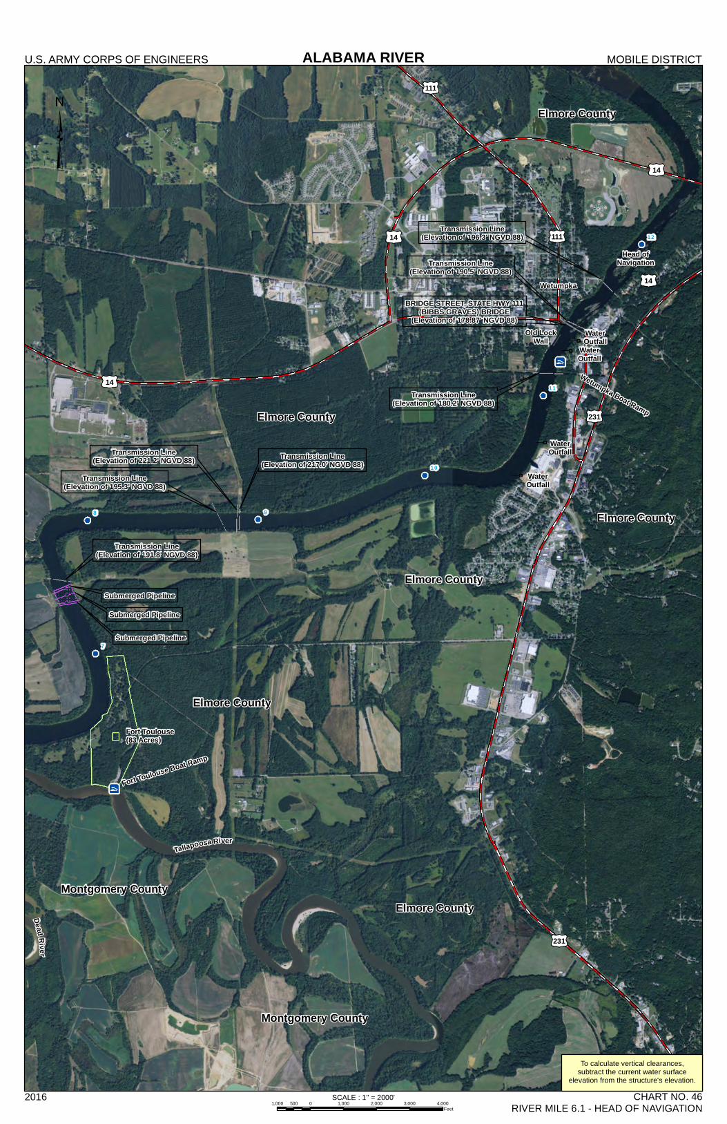
231
14
14 111
14
111
231
14
98
7
12
11
10
ALABAMA RIVERU.S. ARMY CORPS OF ENGINEERS MOBILE DISTRICT
2016 CHART NO. 46RIVER MILE 6.1 - HEAD OF NAVIGATION
SCALE : 1" = 2000'1,000 0 1,000 2,000 3,000 4,000500
Feet
To calculate vertical clearances,subtract the current water surface
elevation from the structure's elevation.
Montgomery County
Elmore County
Submerged Pipeline
Fort Toulouse(83 Acres)
Tallapoosa River
Fort Toulouse Boat Ramp
Submerged Pipeline
Submerged Pipeline
Transmission Line(Elevation of 191.8' NGVD 88)
Transmission Line(Elevation of 195.3' NGVD 88)
Transmission Line(Elevation of 221.2' NGVD 88) Transmission Line
(Elevation of 217.0' NGVD 88)
Transmission Line(Elevation of 180.2' NGVD 88)
Transmission Line(Elevation of 190.5' NGVD 88)
Transmission Line(Elevation of 196.3' NGVD 88)
BRIDGE STREET, STATE HWY 111(BIBBS GRAVES) BRIDGE
(Elevation of 178.87' NGVD 88)
Wetumpka
Wetumpka Boat Ramp
Head ofNavigation
Montgomery County
Elmore County
Elmore County
Elmore County
Elmore County
Elmore County
Old LockWall
WaterOutfall
WaterOutfall
WaterOutfall
WaterOutfall
Dead Rive r