urbanization and natural disasters in the mediterranean ... · 1 hans günter brauch urbanization...
TRANSCRIPT
1
Hans Günter Brauch
Urbanization and Natural Disasters in the Mediterranean Population Growth and Climate Change in the 21st Century
Case Studies on Izmit, Algiers and Alexandria This paper analyzes the relationship between urbanization – in relation with population
growth and climate change – (as causes) and natural disasters as outcomes of environmental
stress for the Mediterranean region from 1900 to 2001 – with a specific focus at three case
studies in Turkey, Algeria and Egypt. It includes trends of urbanization up to 2015/2030, for
population growth up to 2050, and projections of climate change impact models until 2100
that will increase both the vulnerability to and impact of natural disasters. Based on a medium
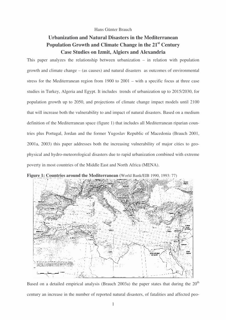
definition of the Mediterranean space (figure 1) that includes all Mediterranean riparian coun-
tries plus Portugal, Jordan and the former Yugoslav Republic of Macedonia (Brauch 2001,
2001a, 2003) this paper addresses both the increasing vulnerability of major cities to geo-
physical and hydro-meteorological disasters due to rapid urbanization combined with extreme
poverty in most countries of the Middle East and North Africa (MENA).
Figure 1: Countries around the Mediterranean (World Bank/EIB 1990, 1993: 77)
Based on a detailed empirical analysis (Brauch 2003a) the paper states that during the 20th
century an increase in the number of reported natural disasters, of fatalities and affected peo-
2
ple could be observed in the Mediterranean region. But the number of fatalities diverged be-
tween the five South European EU countries (Portugal, Spain, France, Italy, Greece) and the
other riparian countries on the Balkans and in the MENA region (table 4).
After a brief reference to the theoretical and conceptual context (2), a model will be outlined
(3), the trends in population growth (4), in urbanization and the different growth patterns of
mega-cities will be analyzed (5), and the projected regional climate change impacts will be
noted (6) before a survey of reported disasters for the Mediterranean (7) will be offered and
two cases of recent impacts of disasters on urban regions (8) will be discussed for Izmit
(earthquake of 1999), Algiers (flash flood of 2001), and the impact of the projected sea-level
rise will be discussed for Alexandria (9). The paper concludes with suggestions to reduce the
vulnerability and to mitigate against the impact of disasters in the Mediterranean (10).
1. Rising vulnerability to disasters due to urbanization in the Mediterranean
These three cases refer to three types of natural disasters: a) rapid-onset geophysical (earth-
quake in Turkey), b) and hydro-meteorological (flash flood in Algeria), and c) slow-onset sea
level rise (in Nile Delta) in three urbanized, densely populated, and highly vulnerable areas.
During the 21st century, due to population growth the urban vulnerability will rise as will ex-
treme weather events, due to regional climate change impacts, leading to more frequent and
intensive hydro-meteorological hazards both globally and regionally. The paper argues that a
North-South cleavage (gap?) in vulnerability to disasters may increase due to these factors:
• The vulnerability to disasters is likely increase with the increase of mega-cities with huge
informal housing quarters if no major progress is achieved with regard to poverty eradica-
tion (DFID et al. 2001), disaster preparedness, and improved urban building standards.
• The number and impact of extreme weather events (meteorological hazards, Hewitt 2002,
2002a) and of climate change impacts (temperature increase, sea-level rise) is likely to in-
crease and affect the densely populated and highly vulnerable Mediterranean mega-cities.
3
• While the Mediterranean has been an eco-region for millennia (Brauch 2001, 2003), a
major obstacle for an effective pan-Mediterranean strategy of disaster reduction, prepared-
ness and risk management has been that the Mediterranean space is institutionally divided
among three continents: Europe, Africa and Asia and that no common strategy exists.
Both geophysical and hydro-meteorological disasters in the Mediterranean region share com-
mon features due to the common geological history and climate. But the nature and human-in-
duced regional environmental challenges have already and will impact differently on the Medi-
terranean. The Mediterranean Sea is not only the meeting point of three continents, it is also a
dividing line where industrial and developing countries meet, and where the gap in GDP/capita
has widened during past decades. While climate change, desertification and the hydrological
cycle (supply factors) have contributed to severe environmental degradation on either side of the
Sea during in the 20th century (Brauch 2001, 2002a), the human-induced demand factors (popu-
lation growth, urbanization, agriculture/food) have differed and will continue to cleavage even
more during the 21st century. These trends have impacted on the different degrees of vulnerabil-
ity of urban centers to natural disasters in Europe and in the MENA region.
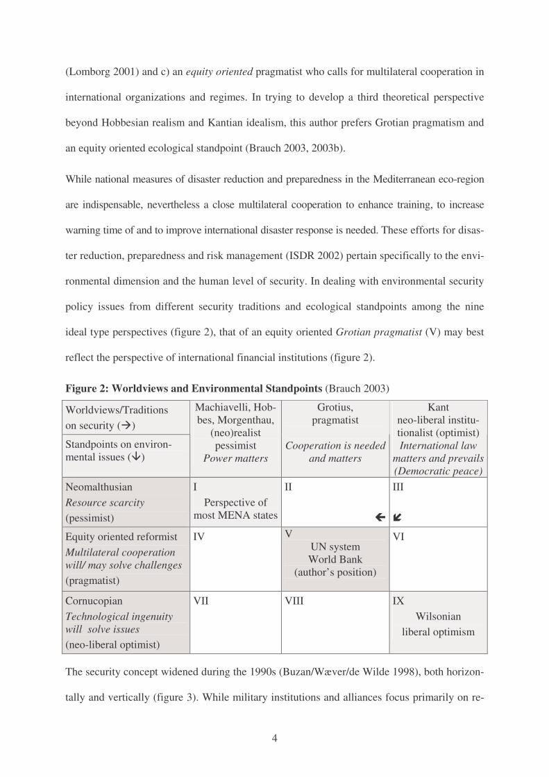
2. Theoretical context: Human and environmental security from a Gro-tian security and an equity oriented ecological perspective
The reality of problems we observe is influenced by our intellectual traditions, our world-
views or mindsets, and our culturally and theoretically guided conceptual lenses (figure 1). On
international (security) policy three traditions may be distinguished in the English school: a)
the Hobbesian pessimist where power is the key category; b) the Kantian optimist where in-
ternational law is crucial and c) the Grotian pragmatist where cooperation is vital (Wight
1991; Bull 1977; Brauch 1996, 2003b). On international environment policy three standpoints
may be distinguished (Homer-Dixon 1998; Gleditsch 2003) that of a) a Malthusian pessimist
who claims that resource scarcities will continue to rise, b) a Cornucopian optimist who ar-
gues that there are plenty of resources and that technology will cope with all challenges
4
(Lomborg 2001) and c) an equity oriented pragmatist who calls for multilateral cooperation in
international organizations and regimes. In trying to develop a third theoretical perspective
beyond Hobbesian realism and Kantian idealism, this author prefers Grotian pragmatism and
an equity oriented ecological standpoint (Brauch 2003, 2003b).
While national measures of disaster reduction and preparedness in the Mediterranean eco-region
are indispensable, nevertheless a close multilateral cooperation to enhance training, to increase
warning time of and to improve international disaster response is needed. These efforts for disas-
ter reduction, preparedness and risk management (ISDR 2002) pertain specifically to the envi-
ronmental dimension and the human level of security. In dealing with environmental security
policy issues from different security traditions and ecological standpoints among the nine
ideal type perspectives (figure 2), that of an equity oriented Grotian pragmatist (V) may best
reflect the perspective of international financial institutions (figure 2).
Figure 2: Worldviews and Environmental Standpoints (Brauch 2003)
Worldviews/Traditions on security (�)
Standpoints on environ-mental issues (�)
Machiavelli, Hob-bes, Morgenthau,
(neo)realist pessimist
Power matters
Grotius, pragmatist
Cooperation is needed
and matters
Kant neo-liberal institu-tionalist (optimist) International law
matters and prevails (Democratic peace)
Neomalthusian Resource scarcity (pessimist)
I Perspective of
most MENA states
II
�
III
�
Equity oriented reformist Multilateral cooperation will/ may solve challenges (pragmatist)
IV
V UN system World Bank
(author’s position)
VI
Cornucopian Technological ingenuity will solve issues (neo-liberal optimist)
VII
VIII IX Wilsonian
liberal optimism
The security concept widened during the 1990s (Buzan/Wæver/de Wilde 1998), both horizon-
tally and vertically (figure 3). While military institutions and alliances focus primarily on re-
5
gional and national security with military means, international organizations have used con-
cepts of environmental (NATO, OECD, OSCE) and human security (UNDP 1994). Environ-
mental security refers to implications of environmental degradation, scarcity and stress on
disasters, migration, crises, conflicts and on their resolution, prevention and avoidance (figure 4).
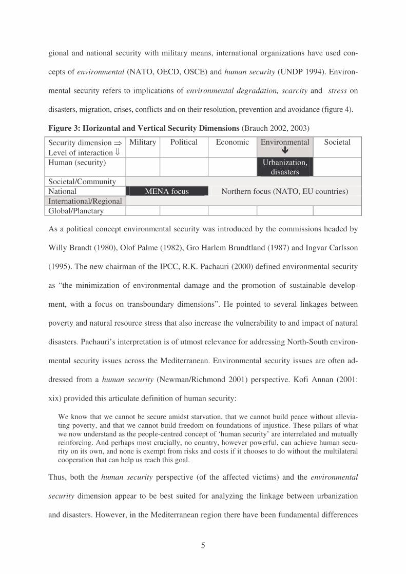
Figure 3: Horizontal and Vertical Security Dimensions (Brauch 2002, 2003)
Security dimension � Level of interaction �
Military Political Economic Environmental �
Societal
Human (security) Urbanization, disasters
Societal/Community National MENA focus Northern focus (NATO, EU countries) International/Regional Global/Planetary
As a political concept environmental security was introduced by the commissions headed by
Willy Brandt (1980), Olof Palme (1982), Gro Harlem Brundtland (1987) and Ingvar Carlsson
(1995). The new chairman of the IPCC, R.K. Pachauri (2000) defined environmental security
as “the minimization of environmental damage and the promotion of sustainable develop-
ment, with a focus on transboundary dimensions”. He pointed to several linkages between
poverty and natural resource stress that also increase the vulnerability to and impact of natural
disasters. Pachauri’s interpretation is of utmost relevance for addressing North-South environ-
mental security issues across the Mediterranean. Environmental security issues are often ad-
dressed from a human security (Newman/Richmond 2001) perspective. Kofi Annan (2001:
xix) provided this articulate definition of human security:
We know that we cannot be secure amidst starvation, that we cannot build peace without allevia-ting poverty, and that we cannot build freedom on foundations of injustice. These pillars of what we now understand as the people-centred concept of ‘human security’ are interrelated and mutually reinforcing. And perhaps most crucially, no country, however powerful, can achieve human secu-rity on its own, and none is exempt from risks and costs if it chooses to do without the multilateral cooperation that can help us reach this goal.
Thus, both the human security perspective (of the affected victims) and the environmental
security dimension appear to be best suited for analyzing the linkage between urbanization
and disasters. However, in the Mediterranean region there have been fundamental differences
6
in the conceptualization of security: while there has been a widening of the security concept in
the UN family and in most EU Mediterranean countries, in the Mashreq (Selim 2003), in Is-
rael (Kam 2003) and Turkey (Aydin 2003) the narrow hard security focus on military and
political factors has prevailed. This had an impact on the security discourses in the North and
the South where different concepts of space, sovereignty and security are still being used.
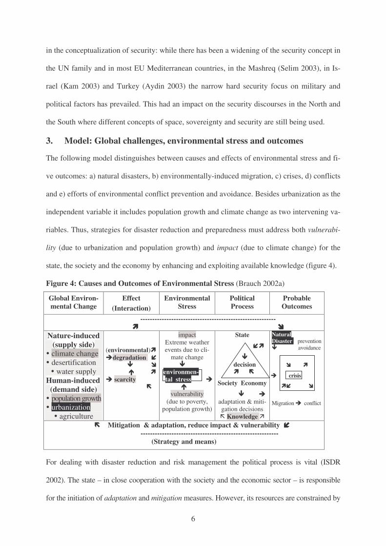
3. Model: Global challenges, environmental stress and outcomes
The following model distinguishes between causes and effects of environmental stress and fi-
ve outcomes: a) natural disasters, b) environmentally-induced migration, c) crises, d) conflicts
and e) efforts of environmental conflict prevention and avoidance. Besides urbanization as the
independent variable it includes population growth and climate change as two intervening va-
riables. Thus, strategies for disaster reduction and preparedness must address both vulnerabi-
lity (due to urbanization and population growth) and impact (due to climate change) for the
state, the society and the economy by enhancing and exploiting available knowledge (figure 4).
Figure 4: Causes and Outcomes of Environmental Stress (Brauch 2002a)
Global Environ-mental Change
Effect (Interaction)
Environmental Stress
Political Process
Probable Outcomes
--------------------------------------------------------- ���� ����
Nature-induced (supply side)
� climate change � desertification � water supply
Human-induced (demand side)
� population growth � urbanization
� agriculture
(environmental)� degradation � � � � scarcity �
impact Extreme weather events due to cli-
mate change � environmen- tal stress
vulnerability
(due to poverty, population growth)
State
��
� decision � �
Society Economy
� adaptation & miti-gation decisions � Knowledge
Natural Disaster prevention � avoidance
� �
crisis
�� �
Migration conflict
� Mitigation & adaptation, reduce impact & vulnerability ���� ----------------------------------------------------------
(Strategy and means)
For dealing with disaster reduction and risk management the political process is vital (ISDR
2002). The state – in close cooperation with the society and the economic sector – is responsible
for the initiation of adaptation and mitigation measures. However, its resources are constrained by
7
socio-economic (stage of development, poverty) and political factors (political will, governance
deficiencies etc.). Human vulnerability and the number of fatalities can be reduced by disaster
preparedness by capacity building within the society (e.g. by NGOs; IFRC), by improved early
warning systems and improved building standards whose implementation is closely linked with
available economic resources, success in poverty eradication and good governance (figure 9).
Disasters (Hewitt 2002, Smith 2001; Abramovitz 2001) may be the result of purely natural proc-
esses (geophysical disasters) as well as of anthropogenic factors (climate change, desertification,
hydro-meteorological events) and of unintended technological malfunctioning (Bhopal) or of a
deliberate terrorist attack. Natural disasters (drought, flood, storms) may be a cause for nature-
induced migration (UNHCR/IOM/RPG 1996), for distress migration (Meze-Hausken 1998) and
for environmental refugees (El-Hinnawi 1985; Myers 1995; Brauch 2000/01) but also – in com-
bination with other causes – for domestic or international crises that may escalate into violent con-
flicts, or that may be avoided by efforts of conflict resolution, prevention and avoidance (Brauch
2002a, 2003). Natural disasters (e.g. in the Sahel, Bangladesh, Central America) have already be-
come one among several triggers for environmentally induced migration, that have let in some
cases to domestic crises, for example violent hunger riots in Morocco in 1984 and 1990, or to
deadly conflicts with tribal people in Assam and in the Chittagong Hill Tract in South Asia.
4. Population growth in the Mediterranean region (1850-2050)
Urbanization is caused by many factors: a population in rural areas without any job perspectives
(push-factors), by the attractiveness of cities (pull-factors), by the structure of the economy, and
the stage of economic development (Rakodi 1997; Lo/Yeung 1998; Mitchell 1999; UNCHS
2001, 2001a). In many developing countries, population growth has been a major driver for the
rapid growth of the mega-cities and for informal housing quarters that are highly vulnerable to
any geophysical (earthquake), hydro-meteorological (storm, flood), and technological disaster
(UNEP 2002). Both past population increases and the projected population growth are crucial for
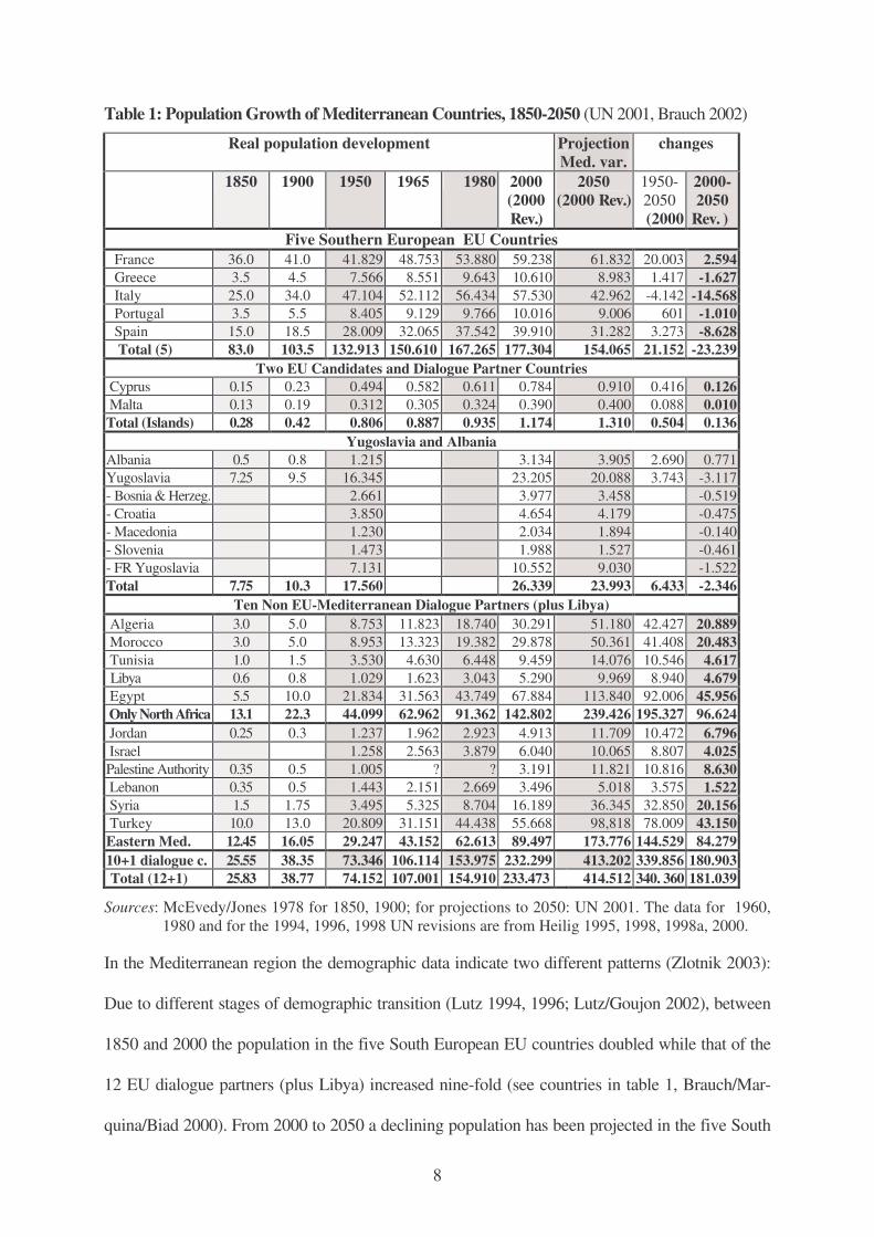
assessing future vulnerabilities to disasters (table 1).
8
Table 1: Population Growth of Mediterranean Countries, 1850-2050 (UN 2001, Brauch 2002)
Real population development Projection Med. var.
changes
1850 1900 1950 1965 1980 2000 (2000 Rev.)
2050 (2000 Rev.)
1950- 2050 (2000
2000- 2050
Rev. ) Five Southern European EU Countries
France 36.0 41.0 41.829 48.753 53.880 59.238 61.832 20.003 2.594 Greece 3.5 4.5 7.566 8.551 9.643 10.610 8.983 1.417 -1.627 Italy 25.0 34.0 47.104 52.112 56.434 57.530 42.962 -4.142 -14.568 Portugal 3.5 5.5 8.405 9.129 9.766 10.016 9.006 601 -1.010 Spain 15.0 18.5 28.009 32.065 37.542 39.910 31.282 3.273 -8.628 Total (5) 83.0 103.5 132.913 150.610 167.265 177.304 154.065 21.152 -23.239
Two EU Candidates and Dialogue Partner Countries Cyprus 0.15 0.23 0.494 0.582 0.611 0.784 0.910 0.416 0.126 Malta 0.13 0.19 0.312 0.305 0.324 0.390 0.400 0.088 0.010 Total (Islands) 0.28 0.42 0.806 0.887 0.935 1.174 1.310 0.504 0.136
Yugoslavia and Albania Albania 0.5 0.8 1.215 3.134 3.905 2.690 0.771 Yugoslavia 7.25 9.5 16.345 23.205 20.088 3.743 -3.117 - Bosnia & Herzeg. 2.661 3.977 3.458 -0.519 - Croatia 3.850 4.654 4.179 -0.475 - Macedonia 1.230 2.034 1.894 -0.140 - Slovenia 1.473 1.988 1.527 -0.461 - FR Yugoslavia 7.131 10.552 9.030 -1.522 Total 7.75 10.3 17.560 26.339 23.993 6.433 -2.346
Ten Non EU-Mediterranean Dialogue Partners (plus Libya) Algeria 3.0 5.0 8.753 11.823 18.740 30.291 51.180 42.427 20.889 Morocco 3.0 5.0 8.953 13.323 19.382 29.878 50.361 41.408 20.483 Tunisia 1.0 1.5 3.530 4.630 6.448 9.459 14.076 10.546 4.617 Libya 0.6 0.8 1.029 1.623 3.043 5.290 9.969 8.940 4.679
Egypt 5.5 10.0 21.834 31.563 43.749 67.884 113.840 92.006 45.956 Only North Africa 13.1 22.3 44.099 62.962 91.362 142.802 239.426 195.327 96.624 Jordan 0.25 0.3 1.237 1.962 2.923 4.913 11.709 10.472 6.796 Israel 1.258 2.563 3.879 6.040 10.065 8.807 4.025 Palestine Authority 0.35 0.5 1.005 ? ? 3.191 11.821 10.816 8.630 Lebanon 0.35 0.5 1.443 2.151 2.669 3.496 5.018 3.575 1.522 Syria 1.5 1.75 3.495 5.325 8.704 16.189 36.345 32.850 20.156 Turkey 10.0 13.0 20.809 31.151 44.438 55.668 98,818 78.009 43.150 Eastern Med. 12.45 16.05 29.247 43.152 62.613 89.497 173.776 144.529 84.279 10+1 dialogue c. 25.55 38.35 73.346 106.114 153.975 232.299 413.202 339.856 180.903 Total (12+1) 25.83 38.77 74.152 107.001 154.910 233.473 414.512 340. 360 181.039
Sources: McEvedy/Jones 1978 for 1850, 1900; for projections to 2050: UN 2001. The data for 1960, 1980 and for the 1994, 1996, 1998 UN revisions are from Heilig 1995, 1998, 1998a, 2000.
In the Mediterranean region the demographic data indicate two different patterns (Zlotnik 2003):
Due to different stages of demographic transition (Lutz 1994, 1996; Lutz/Goujon 2002), between
1850 and 2000 the population in the five South European EU countries doubled while that of the
12 EU dialogue partners (plus Libya) increased nine-fold (see countries in table 1, Brauch/Mar-
quina/Biad 2000). From 2000 to 2050 a declining population has been projected in the five South
9
(-23,2 million) and South-Eastern European (-2,3 million) countries (except Albania), slight in-
creases in Cyprus and major increases in North Africa (+96,6 million) and in the Eastern Mediter-
ranean (+84.3 million), or in the 12 countries (plus in the Occupied Palestinian Territory) on the
southern and eastern shore of the Mediterranean more people will be added until 2050 than pres-
ently live in the five South European EU countries (177.3 million). These different population
growth patterns will affect the different vulnerabilities to disasters around the Mediterranean.
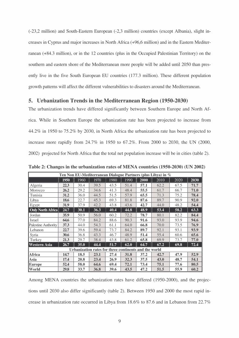
5. Urbanization Trends in the Mediterranean Region (1950-2030) The urbanization trends have differed significantly between Southern Europe and North Af-
rica. While in Southern Europe the urbanization rate has been projected to increase from
44.2% in 1950 to 75.2% by 2030, in North Africa the urbanization rate has been projected to
increase more rapidly from 24.7% in 1950 to 67.2%. From 2000 to 2030, the UN (2000,
2002) projected for North Africa that the total net population increase will be in cities (table 2).
Table 2: Changes in the urbanization rates of MENA countries (1950-2030) (UN 2002) Ten Non EU-Mediterranean Dialogue Partners (plus Libya) in %
1950 1960 1970 1980 1990 2000 2010 2020 2030 Algeria 22.3 30.4 39.5 43.5 51.4 57.1 62.2 67.5 71.7 Morocco 26.2 29.2 34.6 41.3 48.4 55.5 61.7 66.7 71.0 Tunisia 31.2 36.0 44.5 51.5 57.9 65.5 71.3 75.2 78.4 Libya 18.6 22.7 45.3 69.3 81.8 87.6 89.7 90.9 92.0
Egypt 31.9 37.9 42.2 43.8 43.6 42.7 44.0 48.2 54.4 Only North Africa 24.7 30.1 36.3 40.4 44.8 48.9 53.4 58.2 63.3 Jordan 35.9 50.9 56.0 60.2 72.2 78.7 80.1 82.2 84.4 Israel 64.6 77.0 84.2 88.6 90.3 91.6 93.0 93.9 94.6 Palestine Authority 37.3 44.0 54.3 61.1 64.0 66.8 70.0 73.5 76.9 Lebanon 22.7 39.6 59.4 73.7 84.2 89.7 92.1 93.1 93.9 Syria 30.6 36.8 43.3 46.7 48.9 51.4 55.4 60.6 65.6 Turkey 21.3 29.7 38.4 43.8 61.2 65.8 69.9 73.7 77.0 Western Asia 26.7 35.0 44.4 51.7 62.0 64.7 67.2 69.8 72.4
Urbanization rates for three continents and the world Africa 14.7 18.5 23.1 27.4 31.8 37.2 42.7 47.9 52.9 Asia 17.4 20.8 23.4 26.9 32.3 37.5 43.0 48.7 54.1 Europe 52.4 58.0 64.6 69.4 72.1 73.4 75.1 77.6 80.5 World 29.8 33.7 36.8 39.6 43.5 47.2 51.5 55.9 60.2
Among MENA countries the urbanization rates have differed (1950-2000), and the projec-
tions until 2030 also differ significantly (table 2). Between 1950 and 2000 the most rapid in-
crease in urbanization rate occurred in Libya from 18.6% to 87.6 and in Lebanon from 22.7%
10
to 89.7%. The UN projects that by 2030, about 94.6% of the population in Israel will be ur-
ban, 93.9% in Lebanon and 92.0% in Libya, but only 71.6% in Greece, 76.1% in Italy, 81.6 in
Portugal, 82.2% in France and 84.5% in Spain. While in 1950 the urbanization rate in North
Africa was the highest in Egypt with 31.9%, by 2030 with 54.4% it will be the lowest. The
urbanization was higher than in Africa, Asia and the world but lower than in Europe. This trend
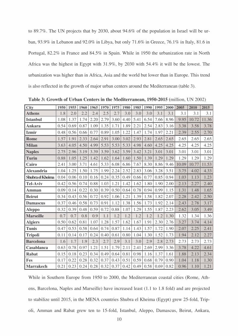
is also reflected in the growth of major urban centers around the Mediterranean (table 3).
Table 3: Growth of Urban Centers in the Mediterranean, 1950-2015 (million, UN 2002)
City 1950 1955 1960 1965 1970 1975 1980 1985 1990 1995 2000 2005 2010 2015 Athens 1.8 2.0 2.2 2.4 2.5 2.7 3.0 3.0 3.0 3.1 3.1 3.1 3.1 3.1 Istanbul 1.08 1.37 1.74 2.20 2.79 3.60 4.40 5.41 6.54 7.66 8.96 9.95 10.72 11.36 Ankara 0.54 0.69 0.87 1.09 1.35 1.71 1.89 2.21 2.54 2.83 3.16 3.38 3.58 3.78 Izmir 0.48 0.56 0.66 0.77 0.89 1.05 1.22 1.47 1.74 1.97 2.21 2.39 2.55 2.70 Rome 1.57 1.91 2.33 2.64 2.91 3.00 3.02 2.93 2.81 2.65 2.65 2.65 2.65 2.65 Milan 3.63 4.05 4.50 4.99 5.53 5.53 5.33 4.98 4.60 4.25 4.25 4.25 4.25 4.25 Naples 2.75 2.96 3.19 3.39 3.59 3.62 3.59 3.42 3.21 3.01 3.01 3.01 3.01 3.01 Turin 0.88 1.05 1.25 1.42 1.62 1.64 1.60 1.50 1.39 1.29 1.29 1.29 1.29 1.29 Cairo 2.41 3.00 3.71 4.61 5.33 6.08 6.86 7.67 8.30 8.86 9.46 10.09 10.77 11.53 Alexandria 1.04 1.25 1.50 1.75 1.99 2.24 2.52 2.83 3.06 3.28 3.51 3.75 4.02 4.33 Shubra el Kheima 0.04 0.06 0.10 0.16 0.24 0.35 0.49 0.66 0.77 0.85 0.94 1.03 1.13 1.23 Tel-Aviv 0.42 0.56 0.74 0.88 1.03 1.21 1.42 1.62 1.80 1.90 2.00 2.13 2.27 2.40 Amman 0.09 0.14 0.22 0.30 0.39 0.50 0.64 0.78 0.94 0.99 1.15 1.31 1.48 1.65 Beirut 0.34 0.43 0.56 0.72 0.92 1.06 1.21 1.39 1.58 1.82 2.07 2.28 2.42 2.50 Damascus 0.37 0.46 0.58 0.73 0.91 1.12 1.38 1.56 1.73 1.92 2.14 2.43 2.78 3.17 Aleppo 0.32 0.39 0.48 0.59 0.72 0.88 1.07 1.29 1.55 1.87 2.23 2.62 3.05 3.49 Marseille 0.7 0.7 0.8 0.9 1.1 1.2 1.2 1.2 1.2 1.2 1.30 1.32 1.34 1.36 Algiers 0.50 0.62 0.81 1.07 1.28 1.57 1.62 1.67 1.91 2.30 2.76 3.27 3.74 4.14 Tunis 0.47 0.53 0.58 0.64 0.74 0.87 1.14 1.43 1.57 1.72 1.90 2.07 2.25 2.41 Tripoli 0.11 0.14 0.17 0.24 0.40 0.61 0.80 1.04 1.30 1.52 1.73 1.94 2.12 2.27 Barcelona 1.6 1.7 1.9 2.3 2.7 2.9 3.1 3.0 2.9 2.8 2.73 2.73 2.73 2.73 Casablanca 0.63 0.78 0.97 1.21 1.51 1.79 2.11 2.41 2.69 2.99 3.36 3.78 4.22 4.61 Rabat 0.15 0.18 0.23 0.34 0.49 0.64 0.81 0.98 1.16 1.37 1.61 1.88 2.13 2.34 Fes 0.17 0.22 0.28 0.32 0.37 0.43 0.51 0.59 0.68 0.79 0.90 1.04 1.18 1.30 Marrakech 0.21 0.23 0.24 0.28 0.32 0.37 0.42 0.49 0.58 0.69 0.82 0.96 1.10 1.21
While in Southern Europe from 1950 to 2000, the Mediterranean coastal cities (Rome, Ath-
ens, Barcelona, Naples and Marseille) have increased least (1.1 to 1.8 fold) and are projected
to stabilize until 2015, in the MENA countries Shubra el Kheima (Egypt) grew 25-fold, Trip-
oli, Amman and Rabat grew ten to 15-fold, Istanbul, Aleppo, Damascus, Beirut, Ankara,
11
Casablanca, Tel-Aviv and Izmir five to ten-fold, and Cairo, Tunis, Alexandria and Algiers
two to five-fold and they are projected to further increase significantly.
Among the 30 largest urban agglomerations, in 1950 two were in the Mediterranean: Milan
was number 14 with 3.633 million, and Cairo was number 25 with 2.410 million. In 2000
Cairo had become number 20 with 9.462 million, and Istanbul number 22 with 8.953 million.
By 2015, according to the UN (2002) urbanization prospects, Cairo will be number 18 with
11.531 million and Istanbul number 19 with 11.362 million.
Mitchell (1999, 1999a: 29) estimated for 1995, among the world’s 20 largest metropolitan
areas the third highest density for Cairo with 37,726 inhabitants per km2. Egyptian authors
(Yousry/Abu-Zekry/Yousry 1998: 301) stated an average population density for the Greater
Cairo region of 32,000, and in Cairo of 78,300 (in the sector of Dar Elsalam even 87,000) and
in Giza 51,300 (in Imbaba and Mounira even 84,000) inhabitants per km2. The growth of in-
formal housing without “building permits” has been “far greater than the capacity of govern-
ment authorities to organize and control it” that have resulted in “unplanned, high-density,
and low-quality developments deprived of basic services and infrastructure”. As in many
mega-cities, the social problems (inequality, unemployment, crime) associated with the ever-
increasing rate of growth in Cairo surpassed the capacity of the government “to cope properly
with … and to manage it.” (Yousry/Atta 1997: 134-137). This rapid urbanization made Cairo
highly vulnerable for disasters. On 12 October 1992, an earthquake in Cairo caused 561 fatali-
ties and economic damages amounting to US$ 1,200 billion (Munich Re 1998).
According to UNCHS (Habitat 2001: 13) in Arab countries “urban growth rates will remain
higher than total population growth rates in the foreseeable future. … Urban growth has been
the result of rural-to-urban migration as well as high fertility and declining rates of mortality.”
The UNHCS notes that “many cities are now going through a critical phase of development,
marked by dwindling resources, increasing poverty, and serious environmental degradation”.
12
Both international governmental and professional organizations as well as individual experts
(Parker/Mitchell 1995; Mitchell 1995, 1999a: 4; Ichikawa 1995) noted “the increasing disas-
ter potential of mega-cities”. IDNDR (1996) listed among 17 cases for the impact of disasters
on urban areas three from the Mediterranean: a) Earthquake in 1980 in Naples, Potenza, Sa-
lerno, Avelino with 3,000 deaths; b) Earthquake in 1992 in Erzincan in Turkey that killed 547
and affected 230,000; and c) earthquake in Cairo that destroyed 5,000 buildings and damaged
12,000. Mitchell (1999: 5) did not include any Mediterranean case among his 10 case studies.
In his conclusions Mitchell (1995b: 475) noted that mega-city hazards are profuse with
floods, earthquakes and windstorms as the most common damaging phenomena, followed by
other risks that triggered disasters: a) slope failures, b) drought/water shortages, c) wildfires,
d) tsunamis, e) volcanoes, f) snow and g) urban fire and air pollution as well as terrorism and
violent urban crime as major social hazards. At the turn of the century Mitchell noted major
changes in mega-city hazards with regard to the composition, the management, and the way
people think on natural hazards but also with regard to interactivity, risks, changes of expo-
sure, vulnerability and in the efficacy of hazard management. Not only vulnerability will rise,
but also the impact of extreme weather events due to climate change.1
5. Climate change: IPCC projections of extreme weather events
According to the Third Assessment Report (TAR) of the Intergovernmental Panel on Climate
Change (IPCC 2001: 4-5), in the 20th century, the average global temperature has increased by
0,6°C and the average sea level has risen between 0.1 and 0.2 meter. Between 1990 and 2100,
the IPCC (2001: 13) stated that “the globally averaged surface temperature is projected to
increase by 1.4 to 5.8°C” and that the mean sea level will rise by 0.09 to 0.88 meters. The
TAR argued that global climate change has already increased the probability of some extreme
weather events during the 20th century and that during the 21st century “more intense precipi-
tation events” and an “increase of the heat index” will become “very likely, over most areas”
(IPCC 2001: 3).
13
Due to regional climate differences “expected climate change give rise to different exposures
to climate stimuli across regions”. Less-developed regions (MENA) are severely vulnerable:
Adverse changes in seasonal river flows, floods and droughts, food security, fisheries, health effects, and loss of biodiversity are among the major regional vulnerabilities and concerns of Africa, Latin America, and Asia where adaptation opportunities are generally low. … In Europe, vulnerability is significantly greater in the south (IPCC 2001a: 15).
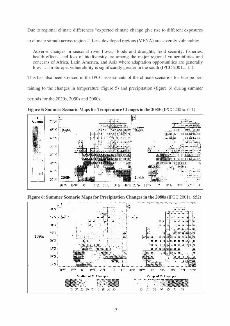
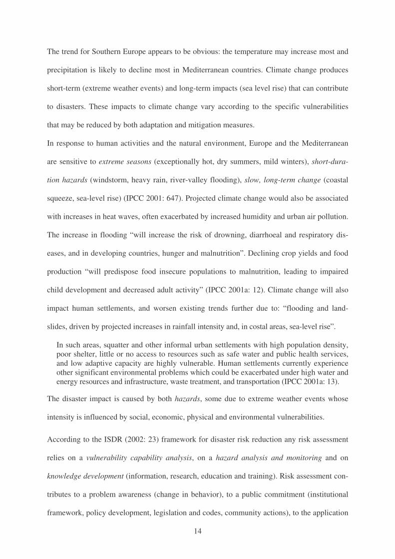
This has also been stressed in the IPCC assessments of the climate scenarios for Europe per-
taining to the changes in temperature (figure 5) and precipitation (figure 6) during summer
periods for the 2020s, 2050s and 2080s.
Figure 5: Summer Scenario Maps for Temperature Changes in the 2080s (IPCC 2001a: 651)
Figure 6: Summer Scenario Maps for Precipitation Changes in the 2080s (IPCC 2001a: 652)
14
The trend for Southern Europe appears to be obvious: the temperature may increase most and
precipitation is likely to decline most in Mediterranean countries. Climate change produces
short-term (extreme weather events) and long-term impacts (sea level rise) that can contribute
to disasters. These impacts to climate change vary according to the specific vulnerabilities
that may be reduced by both adaptation and mitigation measures.
In response to human activities and the natural environment, Europe and the Mediterranean
are sensitive to extreme seasons (exceptionally hot, dry summers, mild winters), short-dura-
tion hazards (windstorm, heavy rain, river-valley flooding), slow, long-term change (coastal
squeeze, sea-level rise) (IPCC 2001: 647). Projected climate change would also be associated
with increases in heat waves, often exacerbated by increased humidity and urban air pollution.
The increase in flooding “will increase the risk of drowning, diarrhoeal and respiratory dis-
eases, and in developing countries, hunger and malnutrition”. Declining crop yields and food
production “will predispose food insecure populations to malnutrition, leading to impaired
child development and decreased adult activity” (IPCC 2001a: 12). Climate change will also
impact human settlements, and worsen existing trends further due to: “flooding and land-
slides, driven by projected increases in rainfall intensity and, in costal areas, sea-level rise”.
In such areas, squatter and other informal urban settlements with high population density, poor shelter, little or no access to resources such as safe water and public health services, and low adaptive capacity are highly vulnerable. Human settlements currently experience other significant environmental problems which could be exacerbated under high water and energy resources and infrastructure, waste treatment, and transportation (IPCC 2001a: 13).
The disaster impact is caused by both hazards, some due to extreme weather events whose
intensity is influenced by social, economic, physical and environmental vulnerabilities.
According to the ISDR (2002: 23) framework for disaster risk reduction any risk assessment
relies on a vulnerability capability analysis, on a hazard analysis and monitoring and on
knowledge development (information, research, education and training). Risk assessment con-
tributes to a problem awareness (change in behavior), to a public commitment (institutional
framework, policy development, legislation and codes, community actions), to the application
15
of risk reduction measures (environmental management, land-use planning, protection of
critical facilities, networks and partnerships, financial tools) and to early warning (figure 9).
7. Analysis of the trends in disasters in the Mediterranean
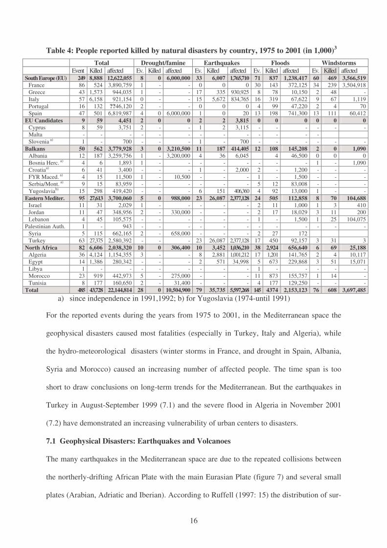
A survey of natural disasters for the years 1975 to 2001 listed in the EM-DAT data base (table
4) and of data supplied by the IFRC (2001: 186-197, 2002: 197-203) for all disasters for the
Mediterranean space for the years from 1980 to 2001 indicate that more than half of all the
natural disasters were reported for the five South European countries (table 4).2
During these 27 years, most natural disasters were reported in France (86), followed by Tur-
key (63), Italy (57), Spain (47), Greece (43), Algeria (36) and Morocco (23). However, with
regard to the number of deaths caused by these events, Turkey ranked first (27,375), followed
by Italy (6,158) and Algeria (4,124), Greece (1,573) and Egypt (1,386). But, with regard to
the number of reported affected persons, Spain was in lead (6,819,987), followed by France
(3,890,759), Albania (3,259,759), Turkey (2,580,392) and Algeria (1,154,355). Around the
Mediterranean most persons died from the effects of earthquakes (Turkey, Italy, Algeria),
while most persons were affected by drought and famine, followed by earthquakes, wind-
storms and floods. From the 1980’s to the 1990’s the number of persons killed by all disasters
increased for Turkey, Egypt, Morocco, Italy and France, while the number of the affected
persons increased most for Spain (due to the reported six million affected persons by the seve-
re drought of 1995) but also for France (due to the winter storm Lothar in December 1999 that
affected more than 3.5 million persons). In Albania the drought and famine of 1991 affected
about 3.2 million, while the earthquakes in Turkey during the 1990’s affected more than 2
million persons. In North Africa, the number of persons reported as affected by natural disas-
ters increased from the 1980’s to the 1990’s for Egypt, Morocco and Algeria while it declined
for Tunisia that had been hard hit by severe floods: in 1990 (96,000), 1982 (30,000) and 1986
(2,500). The flood in Algeria in 2001 caused between 750 (Munich Re 2002) and 921 (IFRC
2002: 197) fatalities and economic damages of US$ 300 million (Munich Re 2002).
16
Table 4: People reported killed by natural disasters by country, 1975 to 2001 (in 1,000)3 Total Drought/famine Earthquakes Floods Windstorms Event Killed affected Ev. Killed affected Ev. Killed affected Ev. Killed affected Ev. Killed affected
South Europe (EU) 249 8,888 12,622,055 8 0 6,000,000 33 6,007 1,765,710 71 837 1,238,417 60 469 3,566,519 France 86 524 3,890,759 1 - - 0 0 0 30 143 372,125 34 239 3,504,918 Greece 43 1,573 944,035 1 - - 17 335 930,925 8 78 10,150 2 48 - Italy 57 6,158 921,154 0 - - 15 5,672 834,765 16 319 67,622 9 67 1,119 Portugal 16 132 ??46,120 2 - - 0 0 0 4 99 47,220 2 4 70 Spain 47 501 6,819,987 4 0 6,000,000 1 0 20 13 198 741,300 13 111 60,412
EU Candidates 9 59 4,451 2 0 0 2 2 3,815 0 0 0 0 0 0 Cyprus 8 59 3,751 2 - - 1 2 3,115 - - - - - - Malta - - - - - - - - - - - - - Slovenia a) 1 - 700 - - - 1 - 700 - - - - - -
Balkans 50 562 3,779,928 3 0 3,210,500 11 187 414,405 12 108 145,208 2 0 1,090 Albania 12 187 3,259,756 1 - 3,200,000 4 36 6,045 4 46,500 0 0 0 Bosnia Herc. a) 4 6 1,893 1 - - - - - - - - 1 - 1,090 Croatiaa) 6 41 3,400 - - - 1 - 2,000 2 - 1,200 - - - FYR Maced. a) 4 15 11,500 1 - 10,500 - - - 1 - 1,500 - - - Serbia/Mont. a) 9 15 83,959 - - - - - - 5 12 83,008 - - - Yugoslaviab) 15 298 419,420 - - - 6 151 406,360 4 92 13,000 1 - -
Eastern Mediter. 95 27,613 3,700,060 5 0 988,000 23 26,087 2,377,128 24 505 112,858 8 70 104,688 Israel 11 31 2,029 1 - - - - - 2 11 1,000 1 3 410 Jordan 11 47 348,956 2 - 330,000 - - - 2 17 18,029 3 11 200 Lebanon 4 45 105,575 - - - - - - 1 - 1,500 1 25 104,075
Palestinian Auth. 1 - 943 - - - - - - - - - - - - Syria 5 115 662,165 2 - 658,000 - - - 2 27 172 Turkey 63 27,375 2,580,392 - - - 23 26,087 2,377,128 17 450 92,157 3 31 3
North Africa 82 6,606 2,038,320 10 0 306,400 10 3,452 1,036,210 38 2,924 656,640 6 69 25,188 Algeria 36 4,124 1,154,355 3 - - 8 2,881 1,001,212 17 1,201 141,765 2 4 10,117 Egypt 14 1,386 280,342 - - - 2 571 34,998 5 673 229,868 3 51 15,071 Libya 1 - - - - - - - - 1 - - - - - Morocco 23 919 442,973 5 - 275,000 - - - 11 873 155,757 1 14 - Tunisia 8 177 160,650 2 - 31,400 - - - 4 177 129,250 - - -
Total 485 43,728 22,144,814 28 0 10,504,900 79 35,735 5,597,268 145 4374 2,153,123 76 608 3,697,485 a) since independence in 1991,1992; b) for Yugoslavia (1974-until 1991)
For the reported events during the years from 1975 to 2001, in the Mediterranean space the
geophysical disasters caused most fatalities (especially in Turkey, Italy and Algeria), while
the hydro-meteorological disasters (winter storms in France, and drought in Spain, Albania,
Syria and Morocco) caused an increasing number of affected people. The time span is too
short to draw conclusions on long-term trends for the Mediterranean. But the earthquakes in
Turkey in August-September 1999 (7.1) and the severe flood in Algeria in November 2001
(7.2) have demonstrated an increasing vulnerability of urban centers to disasters.
7.1 Geophysical Disasters: Earthquakes and Volcanoes
The many earthquakes in the Mediterranean space are due to the repeated collisions between
the northerly-drifting African Plate with the main Eurasian Plate (figure 7) and several small
plates (Arabian, Adriatic and Iberian). According to Ruffell (1997: 15) the distribution of sur-
17
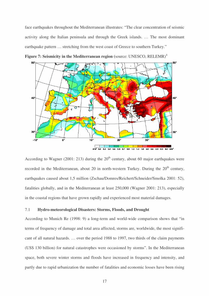
face earthquakes throughout the Mediterranean illustrates: “The clear concentration of seismic
activity along the Italian peninsula and through the Greek islands. … The most dominant
earthquake pattern … stretching from the west coast of Greece to southern Turkey.”
Figure 7: Seismicity in the Mediterranean region (source: UNESCO, RELEMR)4
According to Wagner (2001: 213) during the 20th century, about 60 major earthquakes were
recorded in the Mediterranean, about 20 in north-western Turkey. During the 20th century,
earthquakes caused about 1,5 million (Zschau/Domres/Reichert/Schneider/Smolka 2001: 52),
fatalities globally, and in the Mediterranean at least 250,000 (Wagner 2001: 213), especially
in the coastal regions that have grown rapidly and experienced most material damages.
7.1 Hydro-meteorological Disasters: Storms, Floods, and Drought
According to Munich Re (1998: 9) a long-term and world-wide comparison shows that “in
terms of frequency of damage and total area affected, storms are, worldwide, the most signifi-
cant of all natural hazards. … over the period 1988 to 1997, two thirds of the claim payments
(US$ 130 billion) for natural catastrophes were occasioned by storms”. In the Mediterranean
space, both severe winter storms and floods have increased in frequency and intensity, and
partly due to rapid urbanization the number of fatalities and economic losses have been rising
18
in the eastern and the southern Mediterranean. Due to population growth, the impact of
drought differed in North and South (Mendizabal/Puig 2003).
In Europe, floods are the most common and the most costly natural disaster. From 1991 to
1995, the economic cost of flood damage in Europe has been estimated at 99 billion Euros. A
study by the European Environment Agency (2001) stated that “the main areas prone to fre-
quent floods include the Mediterranean”.5 The report stated: “In general terms, human actions
can influence flooding either by affecting the run-off patterns (e.g. faster run-off through de-
forestation, urbanization and river canalization) or by increasing the possible impact of flood-
ing (e.g. greater exposure of human populations through the occupation of flood plains.”6 Flash
floods with rapid onset characteristics limit warning procedures and emergency actions. “A
major risk factor is the occupation of potential flood areas through uncontrolled building and
inadequate land-use planning. … In Europe, the prevalent zones for flash floods are located
on areas where basins have a short response time and are influenced by Mediterranean cy-
clones.” While the number of flood events and the economic damage they caused have in-
creased from 1992-1998, however, compared with the event in Algeria, the number of human
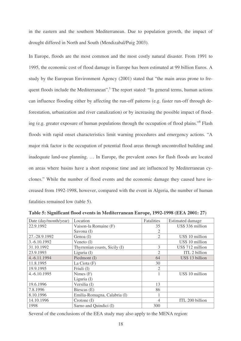
fatalities remained low (table 5).
Table 5: Significant flood events in Mediterranean Europe, 1992-1998 (EEA 2001: 27) Date (day/month/year) Location Fatalities Estimated damage 22.9.1992 Vaison-la Romaine (F)
Savona (I) 35
2 US$ 336 million
27.-28.9.1992 Genoa (I) 2 US$ 10 million 3.-6.10.1992 Veneto (I) US$ 10 million 31.10.1992 Thyrrenian coasts, Sicily (I) 3 US$ 712 million 23.9.1993 Liguria (I) 2 ITL 2 billion 4.-6.11.1994 Piedmont (I) 64 US$ 13 billion 11.8.1995 La Ciota (F) 30 19.9.1995 Friuli (I) 2 4.-6.10.1995 Nimes (F)
Liguria (I) 1 US$ 10 million
19.6.1996 Versilia (I) 13 7.8.1996 Biescas (E) 86 8.10.1996 Emilia-Romagna, Calabria (I) 1 14.10.1996 Crotone (I) 4 ITL 200 billion 1998 Sarno and Quindici (I) 300
Several of the conclusions of the EEA study may also apply to the MENA region:
19
The main pressures that intensify floods and their impacts are climate change, land sealing, changes in the catchment and flood-plan land use, population growth, urbanisation and in-creasing settlement, roads and railways, and hydraulic engineering measures. … Urbanisa-tion increases the frequency of high-flow discharges and reduces the time to reach peak discharges because of soil sealing and increased run-off (EEA 2001: 42-43).
The most costly flash flood reported in November 1995 in Piedmont caused economic dam-
ages of US$ 13 billion but only 64 fatalities (table 5). These differences are due to the diffe-
rent vulnerability of the victims and of the disaster preparedness and response in both events.
8. Vulnerabilities of Cities to Disasters: Cases of Izmit and Algiers
From the comprehensive analysis of disasters in the Mediterranean during the 20th century the
following different trends emerged among the four sub-regions (Brauch 2003a) : a) EU Sou-
thern Europe, b) South-eastern European Mediterranean (Balkans), c) Eastern Mediterranean
(Western Asian) countries, and d) North African countries (table 4).
• From 1975-2001, most natural disasters were reported for Southern Europe (249), follo-
wed by the Eastern Mediterranean (95), North Africa (82) and the Balkans (50).
• The number of fatalities were highest in Turkey (27,375), followed by Italy (6,158), Alge-
ria (4,124), Greece (1,573) and Egypt (1,386). Most fatalities were from earthquakes.
• The total fatalities in the MENA region amounted to 34,219 (79 %). 62 reported floods
killed 3,429 or 79% of a total of 4,374 persons in 145 events in the whole Mediterranean.
• About 82% of fatalities were from earthquakes (35,737), half from two events in Turkey.
• About 47,5% of all persons were affected by drought but thereof 57% by one drought in
Spain in 1995. Due to this drought and a winter storm in France, the number of affected
persons was highest for Southern Europe (two events with 9,566,519 affected persons),
followed by the Balkans, the Eastern Mediterranean and North Africa.
• Of the 38 floods with a total of 2,924 fatalities that hit North Africa from 1975-2001,
about 921 persons (31%) died in the flood that hit Algeria between 9-13 November 2001.
• The case of the earthquake in Western Turkey in August 1999 and the flood that hit Al-
giers in November 2001 were among the most fatal natural events in the MENA region.
20
• Thus, the vulnerability to earthquakes and floods was much higher in the MENA region.
• The vulnerability for a similar event in terms of fatalities was much higher in the Eastern
and Southern Mediterranean than in Southern or Central Europe.
To illustrate this argument two recent cases will be briefly reviewed: a) the earthquake that hit
Western Turkey in August 1999, and b) the severe flood in Algeria in November 2001.
8.1 The Earthquake in Western Turkey in August 1999
In most countries in South-eastern Europe hydro-meteorological events were dominant. How-
ever, in Turkey 23 of 63 reported events (1975-2001) were earthquakes (table 4) that also
caused most fatalities (26,087) and most people that were affected (2,377,128). Earthquakes
were the major natural disaster in Turkey in the 20th century (table 6). In 1998 and 1999, three
earthquakes and one flood in Turkey were among the 100 major disasters worldwide (Munich
Re 1998, 1999, 2000).
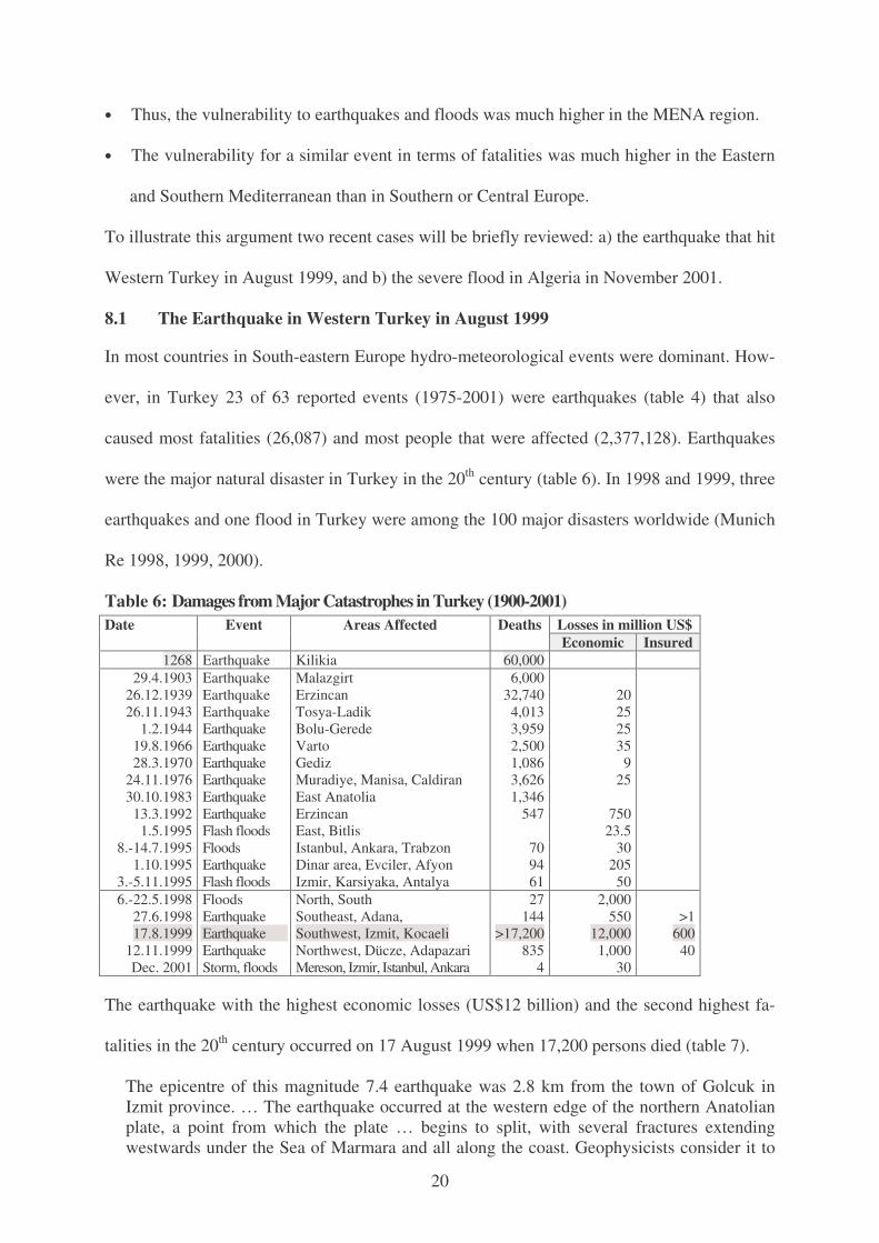
Table 6: Damages from Major Catastrophes in Turkey (1900-2001) Losses in million US$ Date Event Areas Affected Deaths Economic Insured
1268 Earthquake Kilikia 60,000 29.4.1903
26.12.1939 26.11.1943
1.2.1944 19.8.1966 28.3.1970
24.11.1976 30.10.1983 13.3.1992
1.5.1995 8.-14.7.1995
1.10.1995 3.-5.11.1995
Earthquake Earthquake Earthquake Earthquake Earthquake Earthquake Earthquake Earthquake Earthquake Flash floods Floods Earthquake Flash floods
Malazgirt Erzincan Tosya-Ladik Bolu-Gerede Varto Gediz Muradiye, Manisa, Caldiran East Anatolia Erzincan East, Bitlis Istanbul, Ankara, Trabzon Dinar area, Evciler, Afyon Izmir, Karsiyaka, Antalya
6,000 32,740 4,013 3,959 2,500 1,086 3,626 1,346
547
70 94 61
20 25 25 35
9 25
750
23.5 30
205 50
6.-22.5.1998 27.6.1998 17.8.1999
12.11.1999 Dec. 2001
Floods Earthquake Earthquake Earthquake Storm, floods
North, South Southeast, Adana, Southwest, Izmit, Kocaeli Northwest, Dücze, Adapazari Mereson, Izmir, Istanbul, Ankara
27 144
>17,200 835
4
2,000 550
12,000 1,000
30
>1
600 40
The earthquake with the highest economic losses (US$12 billion) and the second highest fa-
talities in the 20th century occurred on 17 August 1999 when 17,200 persons died (table 7).
The epicentre of this magnitude 7.4 earthquake was 2.8 km from the town of Golcuk in Izmit province. … The earthquake occurred at the western edge of the northern Anatolian plate, a point from which the plate … begins to split, with several fractures extending westwards under the Sea of Marmara and all along the coast. Geophysicists consider it to

21
have been one of the strongest [in] this century close to the 7.9 earthquake that destroyed San Francisco in 1906. The 17 August 1999 earthquake …. affected an area of 31,250 km2 and a third of Turkey’s total population (ISDR 2001: 1).
According to official Turkish estimates of 10 September 1999 “the human losses total 15,466
dead, 23,954 injured and more than 600,000 homeless” (ISDR 2001: 7-8).7
Table 7: Human and material losses resulting from the earthquake of 17 August 2001
Provinces Human Losses Material losses by sector: buildings Dead Injured Completely
destroyed Partly
destroyed Slightly
damaged Bolu 264 1,163 3,226 4,782 3,233 Bursa 263 333 32 109 431 Eskisehir 86 83 70 32 204 Istanbul 978 3,547 3,614 12,370 10,630 Kocaeli 4,088 4,174 23,254 21,316 21,481 Golcuk 4,556 5,064 Sakarya 2,627 5,084 20,104 11,381 17,953 Tekirda 35 Yalova 2,501 4,472 10,134 8,870 14,459 Zongudak 3 26 Total 15,466 23,954 60,434 58,860 68,391
The ISDR Report (2001: 17) emphasized that the existing laws and building codes were:
not fully applied. It does not cover a vulnerable segment of the population – squatters liv-ing in isolated regions and carrying on activities not recognized by the Government. In ad-dition, builders are not properly supervised by the local authorities and sometimes come under pressure from owners calling for the original building plants to be modified. This explains why less than 25 percent of the structures erected in urban areas actually conform to building-code requirements.
According to the ISDR report the continued high vulnerability of Turkey is attributable to:
• The population growth and crowding in the urban areas in earthquake zone. The risk to the population is expected to be substantial throughout the next few decades.
• The failure to apply existing building regulations consistently, and the local popula-tion’s lack of awareness of the resulting risks. The technical and scientific knowledge needed to build safely is available. The crux of the problem is ignorance and flouting of the law by all parts of civil society.
• The siting of industrial facilities wherever space is available and in proximity to human settlements, with no regard for environmental protection rules, increase the risk of pol-lution in the event of a disaster (ISDR 2001: 21).
Due to this earthquake, 321,000 people lost their jobs and about 600,000 became homeless.
On 16 November 1999, the World Bank granted two loans “totaling US$757.53 million—a
US$252.53 million Emergency Earthquake Recovery Loan and a US$505 million loan for a
Marmara Earthquake Emergency Reconstruction Project” to assist in the recovery. The Bank
22
assessed the total “fiscal burden from the disaster is estimated to be in the range of US$3.8-
4.6 billion (1.8-2.2 percent of GNP)”, encompassing “the immediate costs of social assis-
tance, the subsequent costs of physical reconstruction, as well as mitigation of damage from
future earthquakes.”8
Emergency Earthquake Recovery Loan (EERL). This … loan will provide financing for incremental private sector import needs resulting from the earthquake and for budgetary expenditures related to recovery efforts, notably social protection for earthquake victims.. … The … loan will help the government provide up-front social protection to displaced persons and other groups made vulnerable by the earthquake, particularly during the up-coming winter months, while longer-term reconstruction efforts get underway.
Marmara Earthquake Emergency Reconstruction Project (MEER). This project focuses on building a sustainable national emergency management response system as a way to reduce the impact of future earthquakes, establishing a disaster insurance scheme, improving land use management and enforcement of building codes, and reestablishing normal living con-ditions in the affected areas by constructing new permanent housing and supporting a trauma program for adults. The components of MEER include the following: - Disaster Response System and Risk Mitigation (US$419.16 million). This component
will finance the design and implementation of a restructured emergency management and response system, support the development of a new Catastrophic Insurance Pool, reduce the vulnerability of the Marmara Earthquake Region to natural disasters by sup-porting land use planning and improved enforcement of construction codes, and estab-lish a land information system for the Marmara Region .
- Trauma Program for Adults (US$6.89 million). This will help reduce the negative ef-fects of the earthquake on the mental health and functional ability of adults.
- Construction of Permanent Housing in Bolu, Kocaeli and Yalova (US$293.32 million). This portion will assist the government of Turkey in reconstructing permanent housing in the urban and rural areas affected by the earthquake.
The total costs of the MEER are US$737.11 million. Other contributors to this project are the government of Turkey (US$176.18 million) and project beneficiaries (US$55.93 mil-lion). The MEER project is part of a Framework Program prepared by the government of Turkey, the Bank, and other donors as a comprehensive response to the earthquake. This Program also includes components to be financed by other partners: business rehabilita-tion; construction of permanent housing; repair of housing and healthcare facilities; and re-building and repair of roads, power distribution networks, and water supply and treatment systems. The EERL and the MEER constitute the new lending components of the Bank’s emergency assistance to Turkey for this earthquake, which totals over US$1 billion.
As of January 2002, 10,000 urban housing units have been completed, 800 rural houses were
constructed, 2.4 million earthquake insurance policies have been issued since September
2000, and the Turkish emergency Management Agency (TEMAD) has been established.9 On
2 September 1999 the European Investment Bank donated an emergency grant of EUR 1 mil-
lion for urgent reconstruction and on 9 February 2000 provided a “EUR 450 million facility”.
23
The EIB's support is part of a larger framework, the “Turkish Earthquake Rehabilitation and Reconstruction Assistance” (TERRA), approved by the EIB for the provinces of Ko-caeli (Izmit), Sakarya (Adapazan), Yalova, and Bolu. The facility provides for a total of EUR 600 million in the form of loans to be engaged over a three-year period. The EIB's first tranche will be used mainly in restoring housing and all essential economic and social infrastructure, including environment, transport, energy, health and education. It has a par-ticular focus on rehabilitating small businesses.10
The impact would be even more severe if a future earthquake should strike Izmir (first degree
of seismic intensity) Istanbul (second degree) or Ankara (second and third degree) due to the
high population density and in those sectors with informal housing of the poor. Many geolo-
gists have predicted a major earthquake with an intensity of at least 7 up to 7.9 on the Richter
scale with a probability of 32% during the next decade and 62% during the next 30 years
when the population of Istanbul and its density will have significantly increased (table 3).11
8.2 The Flood in Algeria in November 2001
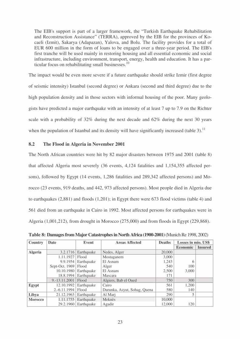
The North African countries were hit by 82 major disasters between 1975 and 2001 (table 8)
that affected Algeria most severely (36 events, 4,124 fatalities and 1,154,355 affected per-
sons), followed by Egypt (14 events, 1,286 fatalities and 289,342 affected persons) and Mo-
rocco (23 events, 919 deaths, and 442, 973 affected persons). Most people died in Algeria due
to earthquakes (2,881) and floods (1,201); in Egypt there were 673 flood victims (table 4) and
561 died from an earthquake in Cairo in 1992. Most affected persons for earthquakes were in
Algeria (1,001,212), from drought in Morocco (275,000) and from floods in Egypt (229,868).
Table 8: Damages from Major Catastrophes in North Africa (1900-2001) (Munich Re 1998, 2002) Losses in mio. US$ Country Date Event Areas Affected Deaths
Economic Insured 3.2.1716 Earthquake Nedes, Alger 20,000
1.11.1927 9.9.1954
Sept-Oct. 1969 10.10.1980 18.8.1994
Flood Earthquake Flood Earthquake Earthquake
Mostaganem El Asnam Alger El Asnam Mascara
3,000 1,243
540 2,500
171
6
100 3,000
Algeria
9.-13.11.2001 Flood Algiers, Bab el Oued 750 300 Egypt 12.10.1992
2.-6.11.1994 Earthquake Flood
Cairo Durunka, Asyut, Sohag, Quena
561 580
1,200 140
Libya 21.12.1963 Earthquake Al Marj 290 5 Morocco 1.11.1755
29.2.1960 Earthquake Earthquake
Meknès Agadir
10,000 12,000
120
24
According to Munich Re, the major disasters in North Africa in the 20th century were earth-
quakes and floods that caused the highest fatalities and economic losses, most of them were
not insured. The most severe event in 2001 were the flash floods that hit Algiers and Bab el
Oued between 9 and 13 November and caused between 750 and 921 deaths (IFRC 2002), and
affected 50,423 persons and caused economic losses in the range of US$ 300 million (table 8).
Disaster Relief gave this description of the event on 13 November: “The 36-hour downpour
… left some 1,000 people injured, overwhelming hospital emergency rooms in Algiers.”
Within a few hours “an average month’s supply of rain bombarded Algiers. … More than 100
millimeters (4 inches) of rain fell in a few hours in central Algiers. … This compares with an
average 93 mm (3.7 inches) the city normally receives in one month in that time of the
year.”12 On 20 November 2001, UNICEF offered this disaster impact assessment that “the
floods have affected over 10,000 families or 40,000 to 50,000 persons, two-thirds of whom
are children. The number of relocated persons is estimated at 24,000.”13 On 26 November
2001, Reuters estimated the human and economic damage: “at up to …US$384 million. Of
the 751 confirmed deaths, 700 were registered in Algiers”.14 USAID described the disaster on
30 November 2001:
Unauthorized housing, built in dry riverbeds, collapsed as a result of the swelling, causing rubble and debris to inundate the lower parts of the city. The [Government of Algeria] GOA reports that the floods left an estimated 40,000 to 50,000 individuals homeless. … According to U.N. Office for the Coordination of Humanitarian Affairs (UNOCHA), seven communes of Algiers were seriously affected by the floods: Bab-El-Oued, Oued Koriche, Bouloghine, Raïs Hamidou, Hammamet, Aïn Bénian, Bouzaréah. … In Bab el Oued, … 651 people were reported to have died. … The GOA estimated that 2,700 buildings were severely damaged …, 37 schools remained closed in the districts of Bab-El-Oued and Bouzareah, and an estimated 109 roads were damaged.15
On 30 November 2001, the IFRC reported the following consequences of the disaster:
A total of 12 740 families were made homeless countrywide, of which 2,770 have been provided shelter, and another 2,224 have been rehoused. Other consequences of the disas-ter include: • 20,000 homes destroyed or seriously damaged; • 573 schools closed and under repair; • 43 health centers damaged and under repair; • the harbors of Algiers, Tenes, Oran and Mostaganem affected; • 12,000 telephone lines damaged;
25
• total damage in Algiers estimated at DA 50 billion (USD 67 million). • more families in need being ‘discovered’ daily.16
The International Federation of the Red Crescent, described its impact on 10 January 2002:
After several months of drought, torrential rain and strong winds of up to 211 kph caused huge mudslides and floods on Saturday 10 November 2001 in the capital Algiers and other regions (wilayas), particularly in coastal zones. … On 18 December, the Government is-sued the latest report on losses. … The number killed has reached 764, of which 713 are from Algiers. A total of 125 people are still missing. Material damage is estimated at more than DA 33 billion (CHF 715 million) throughout the 13 wilayas affected. The wilaya of Algiers was the most affected. The damage there is estimated at DA 16 billion (CHF 346 million). A total of 23,000 houses have been damaged, of which 5,300 will have to be re-built. Of the 13 wilayas that suffered flooding, Algiers and Chlef are the most affected.17
In numerous reports on the Reliefweb on this single event the following reasons were given
for the high vulnerability and number of fatalities of this hydro-meteorological disaster:
• Lack of drainage had resulted in floodwaters and mudslides sweeping through residen-tial areas and causing massive destruction. ... Damage was particularly bad in working-class Bab El Oued, a strongly Islamic district. [Le Soir] said the authorities had in 1997 sealed off the underground drains in Bab El Oued after they found that members of the Muslim fundamentalist group the Armed Islamic Group (GIA), were using them as hiding places to launch attacks on the capital Algiers. … The elaborate drainage sys-tem, built by the French before independence in 1962, was sealed with concrete and unable to carry the floodwaters away.18
• After an assessment … by USAID/OFDA's Urban Disaster Specialist …. it was de-termined that the flood was exacerbated by the inability of the affected areas to retain floodwaters. This … was caused primarily by the over development of housing and roadways in the natural valleys present in the hilly terrain in many parts of Algiers, called oueds. These oueds, while the choice of settlement for many, are extremely sus-ceptible to flash floods. The geography and population density of the city also played major roles in the devastation. …. In the most affected area of [Algiers], population density is greater than that of Manhattan, but the watershed of that area is estimated at only five square miles, with steep slopes, and elevation rising to 1,300 feet. The result of these factors was tremendous amounts of water being forced through densely popu-lated areas out to the sea.19
• Poor planning and worse maintenance … explain the high death toll from flash flood-ing in Algeria. … Flash floods swept away hundreds in Algiers’ poor Bab el Oued neighborhood because safe construction practices were disregarded and sewers not maintained.20
• Bab-el-Oued, a poor area of the city, was especially badly hit. It is located at the outlet of a wadi, a normally dry valley, but houses had been illegally constructed on the bed of the wadi. … The state has shown its incapacity to manage a national catastrophe.21
The factors contributing to the high vulnerability and high number of fatalities refer to high
population density, poor housing on flood-prone regions, severe administrative errors and lack
of implementation of building standards in one of the poorest city sectors.
26
On 8 August 2002, the World Bank approved a US$ 89 million loan on standard terms to Al-
geria “to reduce the urban population’s vulnerability to floods, earthquakes and other natural
disasters”. Algeria contributes US$ 36 million and will play a lead role in its management:
The project will seek to boost the country’s ability to respond to and manage situations of natural disasters, introduce long-term preventive measures as well as undertake reconstruc-tion and reforestation to minimize the susceptibility of the urban poor to future disasters. The four-year project falls in line with the Bank’s interim country assistance strategy for Algeria which focuses on fighting poverty by tackling the problems of low-income hous-ing, substandard construction of homes, water and unemployment in urban centers.
The capital of Algiers and other cities are characterized by a rapid rate of urbanization, which soared from 31 percent in 1996 to nearly 60 percent in 2000. Overcrowded homes, absence of finance markets for housing, and a system of social housing are all contributing to a fast deterioration of the building stock. Home to 3 million people, Algiers is also prone to flash flooding, land and mudslides, and earthquakes. This vulnerability has in-curred financial, social and economic losses on the poor, and diverted financial resources from conventional development efforts to recovery and construction.
Last November, severe rains accompanied by floods and mud-flows resulted in a loss of 800 lives — 95 percent of which occurred in Algiers — and property damage and loss to-taling $400 million. The most seriously affected sector was housing, accounting for 33 percent of the total damage, followed by losses to rain water sewage systems, public infra-structure such as roads, bridges and ports, and agricultural facilities.
The approved project responds to the Government of Algeria’s request for assistance in re-habilitation and prevention in the aftermath of last year’s floods. One component of the project will prepare the government in responding to natural disasters by financing studies, training personnel in national agencies for civil protection, meteorology, and water re-sources, and purchasing equipment for search and rescue operations and medical evacua-tions, among others. Another component of the project will finance emergency reconstruc-tion such as new housing for those who lost their homes to floods last year, water works and reforestation to stabilize soil and limit erosion.22
On 24 July 2002, the EIB granted Algeria a loan of EUR 165 million for reconstructing for a
series of priority infrastructural works damaged by this flood for three projects:
• EUR 45 million for reconstructing a series of priority infrastructural works damaged by the disastrous flooding of 10 November 2001: the project focuses on urgent reha-bilitation of a 5km stretch of the ‘Frais Vallon’ 2 x 2-lane urban road (Bab El Oued - Chevalley) plus construction of a rainwater drainage canal serving western Algiers, temporary repair followed by permanent strengthening of the ‘Mustapha Jetty’ in the Port of Algiers and urgent rebuilding of five bridges on the RN 11 and CW 101 roads.
• EUR 50 million for the road network in Greater Algiers: the project encompasses various priority improvements to the main fabric of the Algiers road system with a view to meeting steadily increasing demand for road travel (+5.3% per annum) stem-ming from the inflow of people into the capital, the difficult terrain and the absence of a well-developed public transport system. …
• EUR 70 million for the Bouira - El Adjiba section of the East-West Motorway, the ini-tial stage of the trans-Maghreb motorway.23
27
According to the urbanization projections (table 3) Algiers is projected to grow by 50% from
2000 to 2015 (2000: 2.76 million and 2015: 4.14 million). According to the IPCC, more ex-
treme precipitation events are projected to become “very likely” during the 21st century.
While population growth and urbanization contribute to increased vulnerability, climate chan-
ge may increase the impact of such severe weather events, especially in the MENA region.
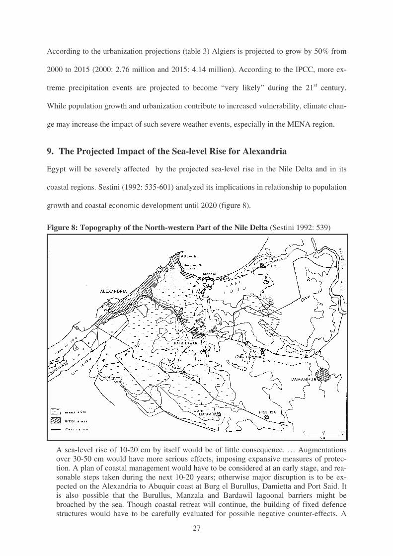
9. The Projected Impact of the Sea-level Rise for Alexandria
Egypt will be severely affected by the projected sea-level rise in the Nile Delta and in its
coastal regions. Sestini (1992: 535-601) analyzed its implications in relationship to population
growth and coastal economic development until 2020 (figure 8).
Figure 8: Topography of the North-western Part of the Nile Delta (Sestini 1992: 539)
A sea-level rise of 10-20 cm by itself would be of little consequence. … Augmentations over 30-50 cm would have more serious effects, imposing expansive measures of protec-tion. A plan of coastal management would have to be considered at an early stage, and rea-sonable steps taken during the next 10-20 years; otherwise major disruption is to be ex-pected on the Alexandria to Abuquir coast at Burg el Burullus, Damietta and Port Said. It is also possible that the Burullus, Manzala and Bardawil lagoonal barriers might be broached by the sea. Though coastal retreat will continue, the building of fixed defence structures would have to be carefully evaluated for possible negative counter-effects. A
28
flooding of the coastal lowlands is not expected. In theory, a sea-level rise … of 100 cm could flood land within 30 km of the coast or more, affecting 12-15% of Egypt’s arable land and 8-10 million people (Sestini 1992: 535).
In his view “the socio-economic structures of the Lower Nile Delta probably will be affected
more by population increase and urbanization, than by climatic changes; … water supply and
food production could be altered” (Sestini 1992: 535-536).
Mohammed El-Raey (1991, 1993, 1994) and a team of Egyptian experts produced a Vulner-
ability Assessment of the Coastal Zone of Egypt to the Impacts of Sea Level Rise which con-
cluded: “that a 0.5 m sea level rise would cause migration of more than 2.0 million people,
loss of more than 214,000 jobs and a value loss of more than US$ 40.0 billion, mainly in Al-
exandria Governorate”. The report contained detailed vulnerability assessments for Alexan-
dria (El-Raey/Ahmed/Korany 1997), Roseta and Port Said (El-Raey/Frihy/Nasr/Dewidar
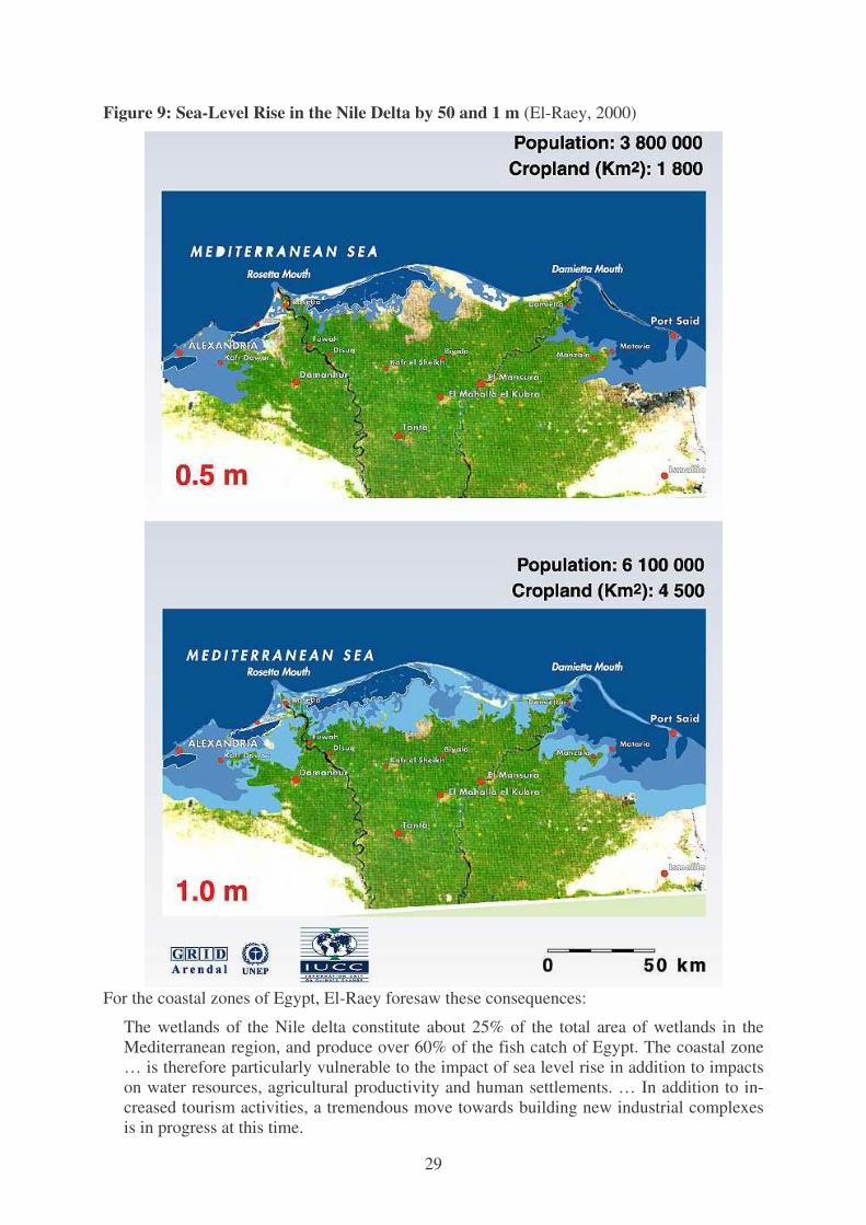
1997). In 2000, El-Raey published a vulnerability assessment of Alexandria governorate for a
sea level rise of 0.5m and 1.0 m (figure 9) by the end of the 21st century.24 In his view: “The
coastal zone of Egypt suffers from a number of serious problems, including a high rate of
population growth, land subsidence, excessive erosion rates, water logging, salt water intru-
sion, soil salination, land use interference ecosystem pollution and degradation, and lack of
appropriate … management systems.” El-Raey discussed different scenarios for an assumed
sea level rise (SLR) of 0.5 m, 1.0 m, and 2.0 m during the 21st century by using remote sens-
ing and GIS techniques to assess vulnerability and identify sectors likely to be most seriously
impacted compared with the present.25 An estimated SLR of 0.5 m in the governorate of Al-
exandria alone would cause a displacement of almost 1.5 million people and the loss of about
200,000 jobs by 2050 without mitigation measures. According to M. El-Raey:
The coastal zone of Egypt extends for more than 3,500 km and is the home of more than 40% of the population. … Alexandria … city has a waterfront that extends for 60 km, from Abu-Qir Bay in the east to Sidi Krier in the west and includes a number of beaches and harbours. Alexandria's beaches are the main summer resort of the country, and its harbours are the most important import/export link between Egypt and Europe. About 40% of all Egyptian industry is located within the governorate of Alexandria.
29
Figure 9: Sea-Level Rise in the Nile Delta by 50 and 1 m (El-Raey, 2000)
For the coastal zones of Egypt, El-Raey foresaw these consequences:
The wetlands of the Nile delta constitute about 25% of the total area of wetlands in the Mediterranean region, and produce over 60% of the fish catch of Egypt. The coastal zone … is therefore particularly vulnerable to the impact of sea level rise in addition to impacts on water resources, agricultural productivity and human settlements. … In addition to in-creased tourism activities, a tremendous move towards building new industrial complexes is in progress at this time.
30
A major cause will be the sea-level rise that has been projected in all IPCC studies and many
other analyses for the Nile Delta (Sestini, 1989; El-Raey, 1993; CRI and Delft 1993). Areas of
high vulnerability “include parts of Alexandria and Behaira governorates, Port Said and Da-
mietta governorates, and Suez governorate. In addition, several other smaller areas, such as
those near Matruh and north of Lake Bardaweel, have also been identified” (El-Raey/Nasr/
Frihy/Desouki/Dewidar 1995). El-Raey discussed different scenarios for an assumed SLR of
0.5 m, 1.0 m, and 2.0 m during the 21st century, mapping vulnerable areas and quantitatively
assessing vulnerable sectors in each area.
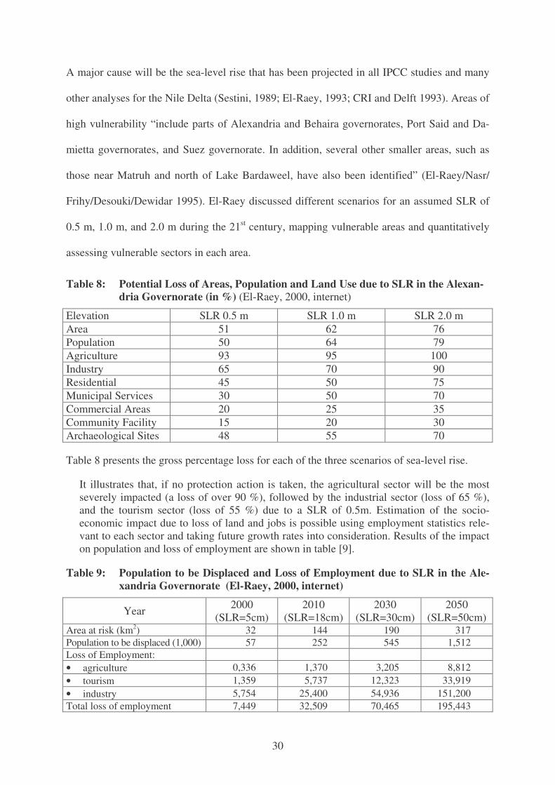
Table 8: Potential Loss of Areas, Population and Land Use due to SLR in the Alexan-dria Governorate (in %) (El-Raey, 2000, internet)
Elevation SLR 0.5 m SLR 1.0 m SLR 2.0 m Area 51 62 76 Population 50 64 79 Agriculture 93 95 100 Industry 65 70 90 Residential 45 50 75 Municipal Services 30 50 70 Commercial Areas 20 25 35 Community Facility 15 20 30 Archaeological Sites 48 55 70
Table 8 presents the gross percentage loss for each of the three scenarios of sea-level rise.
It illustrates that, if no protection action is taken, the agricultural sector will be the most severely impacted (a loss of over 90 %), followed by the industrial sector (loss of 65 %), and the tourism sector (loss of 55 %) due to a SLR of 0.5m. Estimation of the socio-economic impact due to loss of land and jobs is possible using employment statistics rele-vant to each sector and taking future growth rates into consideration. Results of the impact on population and loss of employment are shown in table [9].
Table 9: Population to be Displaced and Loss of Employment due to SLR in the Ale-xandria Governorate (El-Raey, 2000, internet)
Year 2000 (SLR=5cm)
2010 (SLR=18cm)
2030 (SLR=30cm)
2050 (SLR=50cm)
Area at risk (km2) 32 144 190 317 Population to be displaced (1,000) 57 252 545 1,512 Loss of Employment: • agriculture 0,336 1,370 3,205 8,812 • tourism 1,359 5,737 12,323 33,919 • industry 5,754 25,400 54,936 151,200 Total loss of employment 7,449 32,509 70,465 195,443
31
An estimated SLR of 0.5m in the governorate of Alexandria alone would cause a displace-
ment of almost 1.5 million people and the loss of about 200,000 jobs 2050 without mitigation
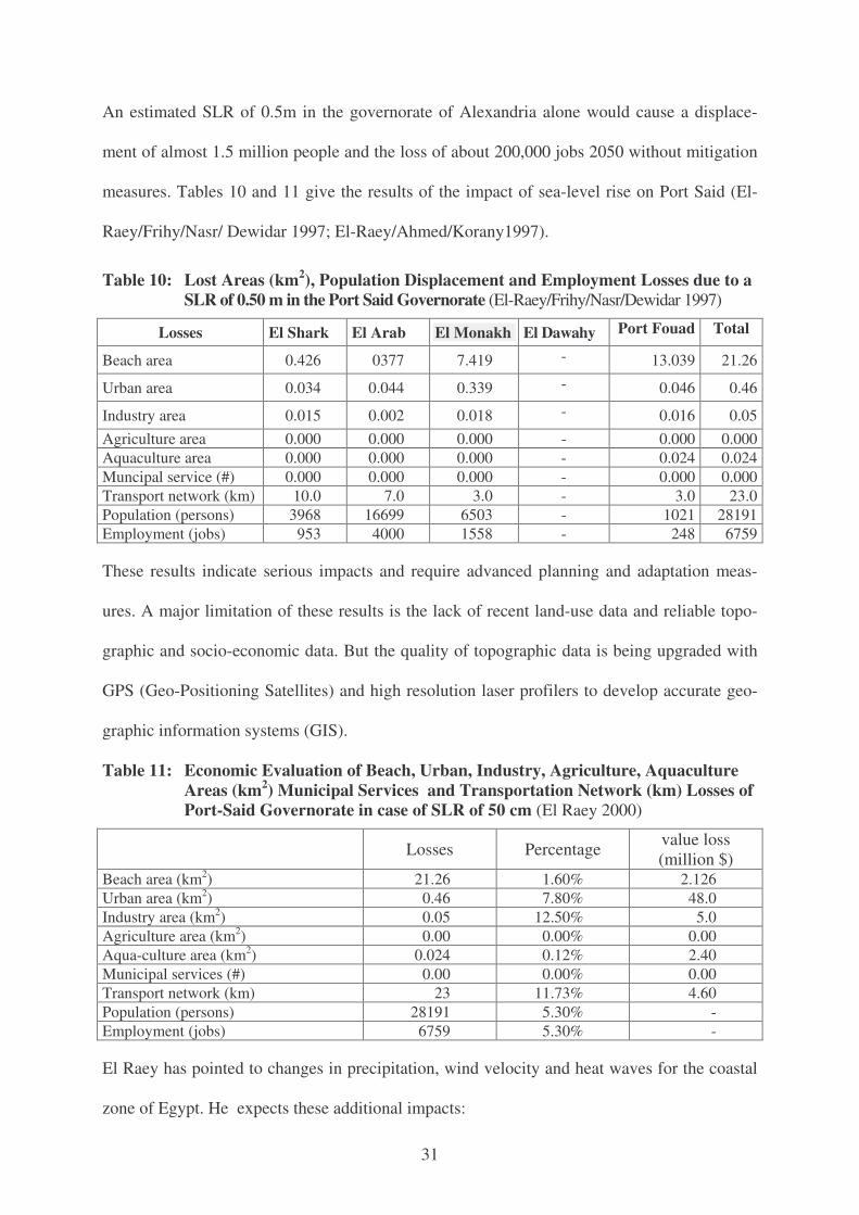
measures. Tables 10 and 11 give the results of the impact of sea-level rise on Port Said (El-
Raey/Frihy/Nasr/ Dewidar 1997; El-Raey/Ahmed/Korany1997).
Table 10: Lost Areas (km2), Population Displacement and Employment Losses due to a SLR of 0.50 m in the Port Said Governorate (El-Raey/Frihy/Nasr/Dewidar 1997)
Losses El Shark El Arab El Monakh El Dawahy Port Fouad Total
Beach area 0.426 0377 7.419 - 13.039 21.26
Urban area 0.034 0.044 0.339 - 0.046 0.46
Industry area 0.015 0.002 0.018 - 0.016 0.05 Agriculture area 0.000 0.000 0.000 - 0.000 0.000 Aquaculture area 0.000 0.000 0.000 - 0.024 0.024 Muncipal service (#) 0.000 0.000 0.000 - 0.000 0.000 Transport network (km) 10.0 7.0 3.0 - 3.0 23.0 Population (persons) 3968 16699 6503 - 1021 28191 Employment (jobs) 953 4000 1558 - 248 6759
These results indicate serious impacts and require advanced planning and adaptation meas-
ures. A major limitation of these results is the lack of recent land-use data and reliable topo-
graphic and socio-economic data. But the quality of topographic data is being upgraded with
GPS (Geo-Positioning Satellites) and high resolution laser profilers to develop accurate geo-
graphic information systems (GIS).
Table 11: Economic Evaluation of Beach, Urban, Industry, Agriculture, Aquaculture Areas (km2) Municipal Services and Transportation Network (km) Losses of Port-Said Governorate in case of SLR of 50 cm (El Raey 2000)
Losses Percentage value loss
(million $) Beach area (km2) 21.26 1.60% 2.126 Urban area (km2) 0.46 7.80% 48.0 Industry area (km2) 0.05 12.50% 5.0 Agriculture area (km2) 0.00 0.00% 0.00 Aqua-culture area (km2) 0.024 0.12% 2.40 Municipal services (#) 0.00 0.00% 0.00 Transport network (km) 23 11.73% 4.60 Population (persons) 28191 5.30% - Employment (jobs) 6759 5.30% -
El Raey has pointed to changes in precipitation, wind velocity and heat waves for the coastal
zone of Egypt. He expects these additional impacts:
32
1. Increased vulnerability of slum areas to wind and flood damage, and increased frequency of floods and fires in rural, as well as in some urban, areas. Settlements built in the path of old stream torrents will be particularly vulnerable.
2. Increased vulnerability of livestock due to shortage of water resources, increased salinity, and loss of grazing sites.
3. Changes in the frequency, timing and duration of heat waves will affect agricultural yields, and increase number and variety of insect pests.
In his assessment the socio-economic impact on coastal settlements will include:
1. Inundation and salt water intrusion will compel a significant proportion of the coastal zone population to abandon their land and homes.
2. Changes in the ecological system of lakes will reduce fish catches and drive away a large portion of fishermen and their dependants.
3. Loss of beaches will reduce the number of tourists in coastal areas, forcing tourism depen-dent individuals and communities to abandon their settlements and look for jobs else-where.
4. Increased saltwater intrusion will affect the management and access to archaeological si-tes; reduce tourism, and result in socio-economic impacts on the inhabitants of these areas.
5. Increased unemployment induces political and civil unrest. 6. Increased waterlogging and salinity give rise to insect and pest problems which in turn
causes health problems. 7. Increases in temperature lead to increased soil erosion and dust. Increased dust has direct
adverse impacts on health, installations and equipment. Increased wind speed encourages sand dune movements and threatens coastal infrastructure.
8. Increased humidity and temperature decrease the human comfort zone, and reduce human productivity.
Finally, El Raey pointed to the following secondary regional impacts which also affect the in-
ternational community that include:
1. Increasing temperature increases soil erosion and wind speed, which in turn increases the amount of Saharan dust carried across the Mediterranean to European countries causing health and economic problems.
2. Increased unemployment increases immigration pressure on European countries. 3. Decrease of water resources increases friction among countries sharing the same water
resources (e.g. Nile and Euphrates), and leads to political unrest. 4. Increases in temperature and humidity increase rates of deterioration of Egyptian archaeo-
logical treasures which are considered among the most important in the world.
M. El-Raey drew the following general conclusions from his analysis:
1. The coastal zone of Egypt is seriously vulnerable to the effects of sea level rise and changes in weather patterns from both the physical and the socio-economic points of view.
2. Large areas of the governorates of Alexandria, Behaira, Kafr El-Shiekh, Port Said, Dami-etta and Suez, are particularly vulnerable to sea level rise. Other vulnerable areas include Lake Bardawil, coast of Obeyedh near Matruh and the coasts of the Bitter lakes. Many other areas on the Red Sea are also vulnerable.
3. The coastal zones as a whole are also particularly vulnerable to changes in precipitation, excessive frequency of storm surges and changes in the heat pattern through the impacts of floods.
33
4. The impacts of accelerated sea level rise (ASLR) through direct inundation, salt water intrusion, deterioration of ecological systems and associated socio-economic conse-quences, have been addressed.
5. Impacts resulting from changes in the precipitation pattern, shortages of fresh water re-sources, loss of already scarce vegetation cover, increased desertification and associated socio-economic impacts, have yet to be studied in depth.
6. The techniques and methodologies for vulnerability assessment of Egypt's coastal zones are reasonably well identified (e.g. IPCC methodology based on remote sensing and GIS ). Although a quantitative pilot study has been carried out for one or more of the vulnerable areas (e.g. Alexandria governorate, Port Said,.....), current data on land use and elevation are needed before reaching a final overall assessment of the potential impacts of climate change on the coastal zones of the country.
7. A program based on a strategic policy for costal protection and adaptation must be ad-vanced and implemented.
Strzepek, Onyeji, Saleh and Yates (1995: 180-200) developed an integrated climate change
impact study that projects Egypt’s future without climate change and the additional impact of
climate change on existing other trends. These changes, as well as the impact of the rising
sea-level on the Nile Delta, will have severe implications for the agricultural sector of Egypt
and for the whole economy. This study assumed a sea-level rise of 37 cm by 2060. One ma-
jor results is that food self-sufficiency would decline from 60% in 1990 to 10% by 2060.
Based on different models, welfare losses are projected to range between –6% and –52%.
The studies by Sestini, El-Raey, the integrated climate simulation and the IPCC assessment
have all projected severe consequences for Alexandria and the Nile delta due to the projected
sea-level rise. Due to high population density and informal housing both Alexandria and
Cairo are highly vulnerable to earthquakes and floods. Due to the projected sea level rise in
the low coastal zones of the Mediterranean, these densely populated areas will be effected,
most particularly in Alexandria, Roseta and Port Said. The vulnerability will increase with the
projected population growth (table 1) and the growth of urban centers (table 3). Alexandria
has been projected to grow by 820,000 persons until 2015. While the SLR will reduce the
arable land, the projected temperature increase and the rise in evapotranspiration will reduce
more water for irrigation and reduce the yield of most agricultural products. Food self-
sufficiency will decline and the import needs will rise significantly (Brauch 20002, 2002a).

34
10. Conclusions: Urbanization and Disaster Preparedness
10.1 Drawing Lessons form the Case Studies
The statistical analysis (7) and the two case studies on rapid-onset disasters (8) and of a pro-
jected slow-onset disaster (9) in the southern and eastern Mediterranean have indicated that:
• Rapid urbanization has increased and will further increase the vulnerability to all types
of disasters, especially for the poor living in informal housing and in flood prone areas.
• Geophysical disasters may also be influenced by human activity. The probability and
intensity of hydro-meteorological disasters has been projected to increase due to cli-
mate change impacts. Rapid urbanization may further increase the vulnerability to all
disasters and the number of fatalities and affected people in the years to come.
• Slow-onset disasters, such as sea-level rise will affect the low Mediterranean coastal
zones, most particularly, the Nile Delta and the city of Alexandria.
To counter the high fatalities of natural disasters in MENA countries, a dual effort is needed:
a) a reduction of the vulnerability of human beings, of the environmental degradation and of
the economic losses from such events; and b) a reduction of the impact of both geophysical
and hydro-meteorological disasters. What strategies and means should be considered to en-
hance the coordination and the implementation of disaster reduction and risk management in
the Mediterranean Basin?
10. 2 International Strategy of Urban Disaster Reduction
The IPCC (2001) observed significant changes in extreme weather events and hydro-meteoro-
logical disasters globally. In response, international regimes (Krasner 1984) and epistemic
communities (Haas 1990, 1993) dealing with disasters have emerged after the International
Decade on Natural Disaster Reduction (IDNDR), especially the International Strategy on Dis-
aster reduction (ISDR) and its inter-Agency Task Force for Disaster Reduction (IATF), the
Provention Consortium of the World Bank, the emergency and disaster reduction efforts of
UNEP and UNDP, the initiatives by NATO’s Euro-Atlantic Disaster Response coordination
35
Centre (EADRCC), efforts by the EU in the area of civil protection of its member countries,
on behalf of the European Space Agency, and by the new joint EU and ESA effort for a Glo-
bal Monitoring on Environment and Security (GMES) that may become operational by 2008.
10.3 Mediterranean Strategy of Urban Disaster Reduction
Dealing with disasters in the Mediterranean as a common regional problem has been impeded
because this space is institutionally separated among three continents. Efforts at disaster re-
duction have been launched in the framework of the Euro-Mediterranean Partnership (EMP),
and on the scientific level information networks (MEDIN), and functional organizations exist
that involve some non-EU Mediterranean member countries in disaster response, prepared-
ness and reduction activities. Nevertheless, in the Mediterranean these efforts are highly frag-
mented (Brauch 2003). Within the UN family, the sub-regional division of the Mediterranean
into Africa, Western Asia, and Europe has impeded efforts for a common disaster strategy for
the tri-continental Mediterranean space. In its regional assessments of climate change, the
IPCC (1998, 2001a) has so far also followed the prevailing UN pattern. Many EU sponsored
research projects, e.g. on climate, land-use changes, desertification and urbanization have
focused primarily on Southern Europe.
Two different regional concepts could overcome existing deficits: the geographic perspective
of the Mediterranean space contained in the Barcelona Convention (1976), in UNEP’s re-
gional seas program and in the Mediterranean Action Plan (MAP) that includes all riparian
countries, and the Euro-Mediterranean space of the Barcelona Declaration (1995) that in-
cludes all 15 EU countries and 12 dialogue partners (table 1). In October 2001, the 27 Euro-
Mediterranean foreign ministers welcomed “the progress made within the Partnership with
regard to a system for preventing, alleviating the effects of and managing disasters” and in the
Valencia Plan of Action of 24 April 2002, they recognized the “contribution and the expe-
rience accumulated by the pilot project on mitigation of natural or manmade disasters”. In the

36
Athens Declaration of 10 July 2002, adopted at the second conference of Euro-Mediterranean
Environment Ministers, the synergies between MAP and SMAP (Short and Medium-Term
Priority Environmental Action Programme) were stressed (Brauch 2003a), but references to
disaster reduction were missing. The pilot project in the EMP context of EU’s DG External
Relations and of civil protection efforts of its DG Environment could be linked more closely.
The joint GMES-initiative of the European Commission and ESA could provide data for a
joint Euro-Mediterranean regional monitoring of the causes contributing to natural disasters
(land-use changes, soil erosion, urbanization) and to the increase in vulnerability, especially
of urban centers in MENA countries (Sari 2003). In the EMP context, experts from all Medi-
terranean countries (including Albania, the post-Yugoslav states and Libya) should join train-
ing exercises to cope with impacts of earthquakes, storms, floods, heat-waves and drought.
A Mediterranean strategy for disaster prevention (MSDR) could be launched by ISDR, and a
Mediterranean Inter-Agency Task Force for Disaster Reduction (MIATF) could closely coor-
dinate the regional efforts of existing UN, EU, Arab and other functional institutions to en-
hance cooperation, research and training for disaster reduction. Humanitarian organizations,
such as the International Federation of the Red Cross and Red Crescent Societies (IFRC-
RCS), but also the industry could play a role in developing affordable insurance schemes for
those countries that have become repeated victims of natural and technological disasters.
10.4 From Disaster Response to Disaster Reduction
A disaster impact assessment and disaster preparedness should become an inherent goal of all
development projects by international financial institutions (e.g. in the Mediterranean Techni-
cal Assistance Programme: METAP), by UN institutions and in the EMP-framework. These
efforts should enhance the awareness, knowledge, the risk assessment and the public com-
mitment. Risk reduction measures should be included in regional efforts for environmental
management, land-use planning, promotion of improved building standards and joint monitor-
37
ing of their proper implementation. GMES may provide better data for all Mediterranean
countries to map highly vulnerable urban regions that have increasingly been hit by natural
disasters in the past.
10.5 Reducing Vulnerability to and Impact of Disasters
The two basic strategic goals of a Mediterranean strategy of disaster reduction require:
a) a reduction of the vulnerability of human beings and of economic losses from disasters;
b) a reduction of the impact of both geophysical and hydro-meteorological disasters.
Reducing the vulnerability of urban centers in the Mediterranean to geophysical and hydro-
meteorological disasters requires a deliberate strategy of poverty eradication and sustainable
development. The EMP (EU) and MAP (UNEP) and international financial institutions such
as the World Bank, and the EIB in METAP offer existing institutional frameworks. Disaster
reduction goals must be integrated in all national, regional and urban development plans.
This presupposes an enhanced knowledge of risk factors for the whole Mediterranean region:
a) of social, economic, physical and environmental vulnerabilities; and b) of all types of haz-
ards and disasters. Many societal and political (awareness, knowledge development by re-
search, education, and training) efforts, a higher public commitment (infrastructure, legisla-
tion, community action), improved specific urban risk assessments, especially of the vulner-
able urban hotspots), improved pan-Mediterranean early warning systems (for seismic and
extreme weather events) and improved national and urban preparedness to permit a rapid and
effective disaster response. In both case studies on Turkey and Algeria major legislative, ad-
ministrative and operational deficits were noted in the press and in international assessments.
Technical measures can contribute to better disaster preparedness: A mapping of disaster-
prone urban regions, the development of specific building codes and of the instruments for
their effective implementation. As the additional population in the MENA region will live in
urban areas by 2050, longer-term preparedness (awareness, training, early warning) becomes
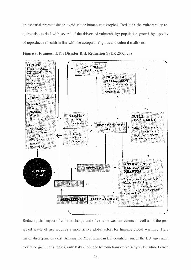
38
an essential prerequisite to avoid major human catastrophes. Reducing the vulnerability re-
quires also to deal with several of the drivers of vulnerability: population growth by a policy
of reproductive health in line with the accepted religious and cultural traditions.
Figure 9: Framework for Disaster Risk Reduction (ISDR 2002: 23)
Reducing the impact of climate change and of extreme weather events as well as of the pro-
jected sea-level rise requires a more active global effort for limiting global warming. Here
major discrepancies exist. Among the Mediterranean EU countries, under the EU agreement
to reduce greenhouse gases, only Italy is obliged to reductions of 6.5% by 2012, while France
39
must maintain its 1990 level, and Portugal may add up to 27%, Greece up to 25% and Spain
up to 15%. Croatia and Slovenia who joined the Annex B of the Kyoto Protocol in 1997 have
agreed to reduce their emissions by 6 or 8% respectively. As an Annex I country under the
UNFCC, Turkey is the only OECD country that never became a party to the UNFCCC and of
the Kyoto Protocol. All other countries have no quantified reduction obligations.
However, as long as policy makers ignore the linkage between causes of environmental stress
and effects and the most likely outcome in terms of disasters (figure 4), no major progress
may be achieved to implement the declared goals of sustainable development. With regard to
EU candidates, the Copenhagen criteria (1993) require them to fully implement all interna-
tional environmental treaties, and the environmental legal requirements of the EU. In addition,
the requirements of the Cardiff process (1998) to include environmental concerns in all sec-
toral policies provides a political lever to promote the goals of disaster reduction in the frame-
work of the EMP to realize the goals, the 27 Foreign Ministers from EMP countries adopted
in the Valencia Plan of Action of April 2002 for “ensuring sustainable development with a
high degree of environmental protection” and of the draft strategy of the Council of the EU
“on environmental integration in the external policies of the General Affairs Council” of 6
March 2002 that stressed the goal of “improving environment integration in dialogue, coop-
eration and assistance with transition and developing country partners”, including in the Euro-
Mediterranean region.26
Whether the dual challenges of both increasing vulnerability and impact are perceived by the
policymakers and the public, and timely and effective countermeasures are launched and ef-
fectively implemented depends on their worldviews and mindsets that determine their politi-
cal priorities (figure 2). Whether governments in the MENA region are willing to shift from a
hard to a soft security agenda with a human security perspectives on environmental security
issues (including disasters) will depend on the resolution of ongoing conflicts.
40
Endnotes
1 The “Urban environment Information gateway” of UNEP, GRID, Arendal: “Cities Environment Reports on
the Internet (CEROI)”, at: <http://www.ceroi.net> does not offer any data on any Mediterranean area. Its ex-tensive list of indicators does not include any disaster related indicators and could not be used for this paper.
2 While both tables rely on the EM-DAT data base, a major difference in both tables applies to data on Syria. 3 EM-DAT includes events where at least one of these criteria apply: a) 10 or more people reported killed, b) 100
people reported affected, c) a call for international assistance or d) a declaration of a state of emergency. 4 See at: <http://www.unesco.org/science/earthsciences/dis.../disasterRELEM_Seismic_haz_map.ht>. 5 See: EU Publication Office: “November 2001 EU topics and new publications – Archive”, at: <http://eur-op.eu.
int/flash/nfarch/200111_en.htm>: 5-6 of 10, accessed at 23 July 2002. The full report can be downloaded at: < http://reports.eea.eu.int/Environmental_Issues_No_21/en/enviissue21.pdf >.
6 Teodoro Estrela, Manuel Menendez, Mirta Dimas, Conception Marcuello, Gwyn Rees, Gwyneth Cole, Karin Weber, Johannes Grath, Jennifer Leonard, Niels Bering Ovesen, Janos Feher: Sustainable water use on Europe, part 3: Extreme hydrological events: floods and droughts. Environmental issue report, No. 21 (Co-penhagen: European Environment Agency, 2001): 11.
7 See ISDR 2001: 7-8. 8 World Bank: “World Bank Provides Earthquake Assistance to Turkey”, News Release No. 2000/094/ECA, 16
November 1999, at: <http://www.worldbank.org/html/exdr/extme/094.htm>. 9 World Bank: “Marmara Earthquake Emergency Reconstruction Project (MEER)”, last updated January 2002
at: <http://www.worldbank.org/>. 10 European Investment Bank: “EUR 450 million EIB support for earthquake rehabilitation and reconstruction in
Turkey”, Press release 2000/003, 9 February 2000, at: <http://www.eib.org/pub/press/2000/pa003.htm>. 11 Hanna Ruitshauser, Kemal Gök: „Zerstöre, töte die Stadt. Istanbul erwartet ein grosses Erdbeben“, in: Neue
Zürcher Zeitung, 17./18 August 2002: 61-63. 12 See: DisasterRelief.org, 13 November 2001, at: <http://www.reliefweb.int>. 13 See: UNICEF, 20 November 2001, at: <http://www.reliefweb.int>. 14 See: Reuters, 26 November 2001, at: <http://www.reliefweb.int>. 15 See: US Agency for International Development (USAID), 30 November 2001: “Algeria - Floods fact sheet #1
(FY02)”, at: Reliefweb: at: <http://www.reliefweb.int>. 16 See IFRC, 30 November 2001, at the Reliefweb at: <http://www.reliefweb.int>. 17 Reliefweb, IFRC: “Algeria: Storms and floods appeal No.35/01 operations update No. 4”, 10 January 2002,
at: <http://www.reliefweb.int>. 18 See: Agence France-Presse (AFP), 12 November 2001, at the Reliefweb at: <http://www.reliefweb.int >. 19 See: US Agency for International Development (USAID), 30 November 2001: “Algeria - Floods fact sheet #1
(FY02)”, at: Reliefweb: at: <http://www.reliefweb.int>. 20 See at: <http://lwf.ncdc.noaa.gov/oa/climate/extremes/2001/november/extremes1101.html#intro>. 21 See Amnesty International at: <http://www.amnesty-volunteer.org/uk/algeria/01Nov.php>. 22 World Bank: “Algeria: World Bank Loan To Reduce Impact Of Natural Disaster On Urban Poor”, News Re-
lease No: 2002/055/MENA, 8 August 2002. at: < http://www.worldbank.org/>, search: “Algeria”; World Bank: “Shielding Algeria from Disaster. World Bank loan will reduce the impact of natural disasters on urban poor”, see also for detailed technical annex and environment impact assessments.
23 European Investment Bank: “Algeria EIB lends EUR 165 million for post-flood reconstruction, the Greater Algiers urban road network and a section of the East-West motorway”, Press release 2002/061, 24 July 2002, at: <http://www.eib.org/pub/press/2002/2002-061.htm>.
24 See: M. El-Raey: “Egypt: Coastal Zone Development and Climate Change Impact of Climate Change on E-gypt”, < http://www.ess.co.at/GAIA/CASES/EGY/impact.htm>.
25 The following quotes are taken from: M. El-Raey : “Egypt: Coastal Zone Development and Climate Change Impact of Climate Change on Egypt”, at: < http://www.ess.co.at/GAIA/CASES/EGY/impact.htm>.
26 See the text at: < http://ue.eu.int/pressData/en/ec/71025.pdf >.
41
������������
Abramovitz, Janet N., 2001: Unnatural Disasters. Worldwatch Paper 158 (Washington: Worldwatch
Institute). Annan, Kofi A., 2001: “Foreword”, in: Mc Rae, Rob; Hubert, Don (Eds.): Human security and the
New Diplomacy. Protecting People, Promoting Peace (Montreal – Kingston – London – Ithaca: Mc Gill –Queen’s University Press): xix.
Aydin, Mustafa, 2003: “Conceptualising of Security in Turkey”, in: Brauch, Hans Günter, Marquina, Antonio; Selim, Mohammed; Liotta, Peter H.; Rogers, Paul (Eds.): Security and Environment in the Mediterranean. Conceptualising Security and Environmental Conflicts (Berlin-Heidelberg: Springer, forthcoming).
Brandt, Willy [Brandt Commission], 1980: North-South. A Program for Survival. Report of the Inde-pendent Commission on International development Issues (New York: Pan Books).
Brauch, Hans Günter, 1996: „Internationale Klimapolitik, Klimaaußen- und Klimainnenpolitik - kon-zeptionelle Überlegungen zu einem neuen Politikfeld“, in: Brauch, Hans Günter (Ed.): Klimapolitik (Berlin-Heidelberg: Springer): 316-317.
Brauch, Hans Günter, 2000/2001: „Environmental Degradation as Root Causes of Migration: Deserti-fication and Climate Change. Long-Term Causes of Migration from North Africa to Europe“, in: Peter Friedrich, Sakari Jutila (Eds.): Policies of Regional Competition. Schriften zur öffentlichen Verwaltung und öffentlichen Wirtschaft, Vol. 161 (Baden-Baden: Nomos, 2000/2001): 102-138.
Brauch, Hans Günter, 2001: “The Mediterranean Space and Boundaries”, in: Marquina, Antonio; Brauch, Hans Günter (Eds.): The Mediterranean Space ant its Borders. Geography, Politics, Eco-nomics and Environment. Collection Strademed 14 (Madrid: UNISCI - Mosbach: AFES-PRESS, 2001): 25-58.
Brauch, Hans Günter, 2001a: “The Mediterranean ‘Space’ Beyond Geopolitique and Globalization. Common Space – Divided Region”. in: Marquina, Antonio; Brauch, Hans Günter (Eds.): The Mediterranean Space ant its Borders. Geography, Politics, Economics and Environment. Collec-tion Strademed 14 (Madrid: UNISCI - Mosbach: AFES-PRESS, 2001): 109-144.
Brauch, Hans Günter, 2002: “A Survival Pact for the Mediterranean: Linking ‘virtual water’ and ‘vir-tual sun’”, in: TERI (Eds..): Global Partnerships for Sustainable Development: Harnessing Action for the 21st Century (New Delhi: TERI, 2002): forthcoming.
Brauch, Hans Günter, 2002: “Climate Change, Environmental Stress and Conflict”, in: BMU (Ed.): title to be added (Berlin: Federal Ministry on the Environment, Nature Conservation and Nuclear Safety).
Brauch, Hans Günter, 2003: “Security and Environment Linkages in the Mediterranean: Fourth Phase of Research on Human and Environmental Security and Peace”, in: Brauch, Hans Günter, Mar-quina, Antonio; Selim, Mohammed; Liotta, Peter H.; Rogers, Paul (Eds.): Security and Environ-ment in the Mediterranean. Conceptualising Security and Environmental Conflicts (Berlin-Heidelberg: Springer, forthcoming).
Brauch, Hans Günter, 2003a: “Natural Disasters in the Mediterranean (1900-2001): From Disaster Response to Disaster Preparedness”, in: Brauch, Hans Günter, Marquina, Antonio; Selim, Moham-med; Liotta, Peter H.; Rogers, Paul (Eds.): Security and Environment in the Mediterranean. Con-ceptualising Security and Environmental Conflicts (Berlin-Heidelberg: Springer, forthcoming).
Brauch, Hans Günter, 2003b: “ Worldviews and Mindsets of Decisionmakers: Hobbesian vs. Grotian or American vs. European Perspectives: Relevance for Security Policy in the Mediterranean”, in: Brauch, Hans Günter, Marquina, Antonio; Selim, Mohammed; Liotta, Peter H.; Rogers, Paul (Eds.): Security and Environment in the Mediterranean. Conceptualising Security and Envi-ronmental Conflicts (Berlin-Heidelberg: Springer, forthcoming).
Brauch, Hans Günter; Marquina, Antonio, Biad, Abdelwahab (Eds.), 2000: Euro-Mediterranean Part-nership for the 21st Century (London: Macmillan – New York: St. Martin’s Press).
Brundtland, Gro Harlem [Brundtland Commission], 1987: Our Common Future. The World Commis-sion on Environment and Development (Oxford – New York: Oxford University Press).
Bull, Hedley, 1977: The Anarchical Society. A Study of Order in World Politics (New York: Columbia University Press).
42
Buzan, Barry; Wæver, Ole; de Wilde, Jaap, 1998: Security. A New Framework For Analysis (Boulder
- London: Lynne Rienner). Carlsson, Ingvar (Chm. of Commission on Global Governance), 1995: Our Global Neighbourhood
(Oxford – New York: Oxford University Press). CRI, Coastal Research Institute; Delft Hydraulics, 1992: Vulnerability assessment to accelerated sea
level rise; Case Study Egypt. ( - Delft: Delft Hydraulics). DFID; EU; UNDP; World Bank, 2001: Linking Poverty Reduction and Environmental Management.
Policy Challenges and Opportunities. A Contribution to the World Summit on Sustainable Devel-opment Process. Consultation Draft (London: DFID; Brussels: EU, DG Research; New York: UNDP; Washington: World Bank).
El-Hinnawi, E., 1985: Environmental Refugees (Nairobi: UNEP). El-Raey, M., 2000: “Egypt: Coastal Zone Development and Climate Change Impact of Climate
Change on Egypt”, at: < http://www.ess.co.at/GAIA/CASES/EGY/impact.htm>. El-Raey, M.; Ahmed, S.; Korany, E., 1997: “Remote Sensing and GIS for Vulnerability Assessment of
the Impact of Sea Level Rise over Alexandria City and Vicinity” (Alexandria, Egypt: Alexandria University, Department of Environmental Studies, Institute of Graduate Studies and Research).
El-Raey, M.; Frihy, O.; Nasr, S. M.; Dewidar, Kh., 1997: “Vulnerability Assessment of Sea level Rise over Port-Said Governorate, Egypt”, Submitted to: Journal of Environmental Monitoring.
El-Raey, M.; Nasr, S.; Frihy, O.; Desouki, S.; Dewidar, Kh., 1995: “Potential impacts of Accelerated sea level rise on Alexandria governorate” in: Egyptian Journal of Coast. Research, special issue # 14.
El-Raey, Mohammed, 1991: “Responses to the Impacts of Greenhouse-Induced Sea-Level Rise on Egypt”, in: Titus, J.G. (Ed.): Changing Climate and the Coast, vol. 2: West Africa, the Americas, the Mediterranean Basin, and the Rest of Europe (Washington, DC: UNEP & USEPA).
El-Raey, Mohammed, 1993: “Vulnerability of the coastal zones”, in: World Coast Conference (Noord-wjik, Netherlands, November).
El-Raey, Mohammed, 1994: Environmental Refugees Case Study: Egypt (Alexandria: University of Alexandria, Department of Environmental Studies).
European Environment Agency [Estrela, Teodoro; Menendez, Manuel; Dimas, Mirta; Marcuello, Conception; Rees, Gwyn; Cole, Gwyneth; Weber, Karin: Grath, Johannes; Leonard, Jennifer ; Be-ring Ovesen, Niels; Feher¸ Janos], 2001: Sustainable water use on Europe, part 3: Extreme hydro-logical events: floods and droughts. Environmental issue report, No. 21 (Copenhagen: European Environment Agency, 2001).
Gleditsch, Nils Petter 2003: “Environmental Conflict: Neomalthusians vs. Cornucopians”, in: Brauch, Hans Günter, Marquina, Antonio; Selim, Mohammed; Liotta, Peter H.; Rogers, Paul (Eds.): Secu-rity and Environment in the Mediterranean. Conceptualising Security and Environmental Conflicts (Berlin-Heidelberg: Springer, forthcoming).
Haas, Peter, 1990: Saving the Mediterranean: The Politics of International Environmental Coopera-tion (New York: Columbia University Press).
Haas, Peter, 1993: „Epistemic Communities and the Dynamics of International Environmental Coop-eration“, in: Rittberger, Volker (Ed.): Regime Theory and International Relations (Oxford: Claren-don Press): 168-201.
Heilig, Gerhard A., 1995: DemoGraphics ’94 (Laxenburg: IIASA). Heilig, Gerhard A., 1998: DemoGraphics ’96. A population education software developed for the
United Nations Population Fund (Vienna: Heilig). Heilig, Gerhard A., 1998a: DemoTables ’96 (Vienna: Heilig). Heilig, Gerhard A., 2000: Demo Tools. Tool # 1:Populations Projections (Vienna: Heilig). Hewitt, Kenneth, 2002: “Natural Hazards“, in: Munn, Ted (Ed.): Encyclopedia of Global Environ-
mental Change, vol. 3: Douglas, Ian (Ed.) Social and Economic Dimensions of Global Environ-mental Change (Chichester: John Wiley): 479-493.
Hewitt, Kenneth, 2002a: “Hazards in Global Environment Change”, in: Munn, Ted (Ed.): Encyclope-dia of Global Environmental Change, vol. 5: Timmerman, Peter (Ed.) Social and Economic Di-mensions of Global Environmental Change (Chichester: John Wiley): 297-303.
Homer-Dixon, Thomas, 1998: Environment, Scarcity and Violence (Princeton: Princeton University Press).
43
Ichikawa, Atsushi, 1995: “Coping with urban disasters”, in: OECD Observer, 197: 15-16. IDNDR, 1996: Cities at Risk. Making Cities Safer Before Disaster Strikes (Geneva: IDNDR). IFRC, 2001: World Disasters Report 2001. Focus on recovery (Bloomfield, CT: Kumarian – London:
Europan): 186-197 IFRC, 2002: World Disasters Report 2002. Focus on reducing risk (Bloomfield, CT: Kumarian – Lon-
don: Europan) : 197-203. IPCC [Intergovernmental Panel on Climate Change], 1998: The Regional Impacts of Climate Change.
An Assessment of Vulnerability (Cambridge – New York: Cambridge University Press). IPPC [Intergovernmental Panel on Climate Change], 2001: Climate Change 2001. The Scientific Basis
(Cambridge – New York: Cambridge University Press). IPPC [Intergovernmental Panel on Climate Change], 2001a: Climate Change 2001. Impacts, Adap-
tation and Vulnerability. Mitigation (Cambridge – New York: Cambridge University Press). IPPC [Intergovernmental Panel on Climate Change], 2001b: Climate Change 2001. Mitigation (Cam-
bridge – New York: Cambridge University Press). ISDR, 2001: The Socio-Economic Consequences of the Earthquake at Izmit, Turkey 17 August 1999
(Geneva: ISDR). ISDR, 2002: Living with Risk. A Global Review of Disaster Reduction Initiatives. Preliminary Version
(Geneva: ISDR, July). Kam, Ephraim, 2003: “Conceptualising Security in Israel”, in: Brauch, Hans Günter, Marquina, Anto-
nio; Selim, Mohammed; Liotta, Peter H.; Rogers, Paul (Eds.): Security and Environment in the Mediterranean. Conceptualising Security and Environmental Conflicts (Berlin-Heidelberg: Springer, forthcoming).
Krasner, Stephen (Ed.), 1983: International Regimes (Ithaca –London: Cornell University Press). Kron, Wolfgang; Berz, Gerhard, 1998: “Wenn Naturereignisse zu Katastrophen werden – Ursachen
und Schadensbilanzen”, in: geospektrum, 2,2: 135-150. Lo, Fu-Chen; Yeung, Yue-Man (Eds.), 1998: Globalization and the World of Large Cities (Tokyo – New
York – Paris: UN University Press). Lomborg, Bjørn, 2001: The Skeptical Environmentalist. Measuring the Real State of the World (Cam-
bridge – New York: Cambridge UP). Lutz, Wolfgang (Ed.), 1994: The Future Population of the World. What Can We Assume Today? (Lon-
don: Earthscan). Lutz, Wolfgang (Ed.), 1996: The Future Population of the World. What Can We Assume Today? Re-
vised and Updated Edition (London: Earthscan). Lutz, Wolfgang; Goujon, Anne, 2002: “Demographic transition“, in: Munn, Ted (Ed.): Encyclopedia of
Global Envriomental Change, Vol. 4: Timmerman, Peter (Ed.): Social and economic dimensions of global environmental change (Chichester: Wiley): 211-214.
Mc Evedy, Colin; Jones, Richard, 1978: Atlas of World Population History (London: Allen Lane). Mendizabal, Teresa; Puig de Fabregas, Juan, 2003: “Population and Land-use Changes: Impacts on De-
sertification in Southern Europe and in the Maghreb”, in: Brauch, Hans Günter, Marquina, Anto-nio; Selim, Mohammed; Liotta, Peter H.; Rogers, Paul (Eds.): Security and Environment in the Mediterranean. Conceptualising Security and Environmental Conflicts (Berlin-Heidelberg: Springer, forthcoming).
Meze-Hausken, Elisabeth, 1998: “Mass-migration due to climate change? A conceptual layout”, at: <http://www. nhh.no/geo/prosjekt/em/project98.html >.
Mitchell; James K., 1995: “Coping with natural hazards and disasters in megacities. Perspectives on the twenty-first century”, in: GeoJournal, 37,3: 303-312.
Mitchell; James K. (Ed.), 1999: Crucibles of Hazard: Mega-Cities and Disasters in Transition (Tokyo – New York – Paris: UN University Press).
Mitchell; James K., 1999a: “Introduction”, in: Mitchell; James K. (Ed.), 1999: Crucibles of Hazard: Mega-Cities and Disasters in Transition (Tokyo – New York – Paris: UN University Press): 1-14.
Mitchell; James K., 1999b: “Findings and Conclusions”, in: Mitchell; James K. (Ed.), 1999: Crucibles of Hazard: Mega-Cities and Disasters in Transition (Tokyo – New York – Paris: UN University Press): 473-502.
Munich Re, 1998: World Map of Natural Hazards (München: Munich Re). Munich Re, 1999: Topics – Annual Review of Natural Catastrophes 1998 (München: Munich Re).
44
Munich Re, 2000: Topics – Annual Review of Natural Catastrophes 1999 (München: Munich Re). Munich Re, 2001: Topics – Annual Review: Natural Catastrophes 2000 (München: Munich Re). Munich Re, 2002: Topics – Annual Review: Natural Catastrophes 2001 (München: Munich Re). Myers, Norman, 1995: Environmental Exodus. An Emergent Crisis in the Global Arena (Washington,
DC: Climate Institute). Newman, Edward; Richmond, Oliver P. (Ed.), 2001: The United Nations and Human Security (Bas-
ingstoke – New York: Palgrave). Pachauri, R.K.: “Environmental Security: A Developing Country Perspective”, meeting report of the
Wilson Center, Environmental Change and Security Project, Current Events, 17 October 2000, at: <http://ecsp.si.edu/archive/rk-pauchari.htm>.
Palme, Olof [Palme Commission], 1982: Common Security. A Programme for Disarmament. The Report of the Independent Commission on Disarmament and Security Issues (London: Pan Books).
Parker, Dennis; Mitchell; James K., 1995: “Disaster vulnerability and megacities. An expanding prob-lem that requires rethinking and innovative responses”, in: GeoJournal, 37,3: 295-302.
Rakodi, Carole (Ed.), 1997: The Urban Challenge in Africa. Growth and Management of its Large Cities (Tokyo – New York – Paris: UN University Press).
Ruffell, Alastair, 1997: “Geological Evolution of the Mediterranean Basin”, in: King, Russell; Proud-foot, Lindsay; Smith, Bernard (Eds.), 1997: The Mediterranean. Environment and Society (London – New York: Arnold): 12-29.
Sari, Djilali, 2003: “Increasing Urbanisation and Pollution in the MENA Region: Causes of Con-flicts?”, in: Brauch, Hans Günter, Marquina, Antonio; Selim, Mohammed; Liotta, Peter H.; Rogers, Paul (Eds.): Security and Environment in the Mediterranean. Conceptualising Security and Envi-ronmental Conflicts (Berlin-Heidelberg: Springer, forthcoming).
Selim, Mohammad El-Sayed, 2003: “Conceptualising Security by Arab Mashreq Countries”, in: Brauch, Hans Günter, Marquina, Antonio; Selim, Mohammed; Liotta, Peter H.; Rogers, Paul (Eds.): Security and Environment in the Mediterranean. Conceptualising Security and Envi-ronmental Conflicts (Berlin-Heidelberg: Springer, forthcoming).
Sestini, G., 1989: “Report on the Seminar on Implications of climatic changes in the Nile Delta” (UNEP)
Sestini, G., 1992: “Implications of Climatic Changes for the Nile Delta”, in: Jeftic, Lubomir; Milli-man, J.D.., Sestini, G. (Eds.): Climatic Change and the Mediterranean. Environmental and Societal Impacts of climate Change and sea-level Rise in the Mediterranean Region (London – New York – Melbourne – Auckland: Edward Arnold): 535-601.
Smith, Keith, 2001: Environmental Hazards. Assessing Risk and Reducing Disaster, 3rd ed. (London – New York: Routledge).
Strzepek, Kenneth; Onyeji, S. Chibo; Saleh, Magda; Yates, David N., 1995: „An Assessment of Inte-grated Climate Change Impacts on Egypt“, in: Strzepek, Kenneth; Smith, Joel B. (Eds.): As Cli-mate Changes. International Impacts and Implications (Cambridge - New York: Cambridge Uni-versity Press): 180-200.
UN, 1997: World Population Prospects. The 1996 Revision. Highlights (New York: UN Population Division, Department of Economic and Social Affairs, United Nations Secretariat).
UN, 2000: World Urbanization Prospects. The 1999 Revision. Data Tables and Highlights (New York: UN Population Division, Department of Economic and Social Affairs, United Nations Secre-tariat).
UN, 2001: World Population Prospects. The 2000 Revision. Highlights (New York, Population Divi-sion, Department of Economic and Social Affairs, UN Secretariat, 28 February 2001).
UN, 2002: World Urbanization Prospects. The 2001 Revision. Data Tables and Highlights (New York: UN Population Division, Department of Economic and Social Affairs, United Nations Secre-tariat).
UNCHS, Habitat, 2001: Cities in a Globalising World. Global Report on Human Settlements 2001 (Nairobi: UNCHS).
UNCHS, Habitat, 2001a: The State of the World’s Cities 2001 (Nairobi: UNCHS, 2001). UNDP, 1994: United Nations Human Development Report, 1994 (New York: UN). UNEP: Global Environmental Outlook 3 (London-Sterling Va.: Earthscan, 2002): 270-296
45
UNHCR, IOM, RPG, 1996: Environmentally-Induced Population Displacements and Environmental
Impacts Resulting from Mass Migrations (Geneva: IOM). Wagner, Horst-Günter, 2001: Mittelmeerraum. Geographie, Geschichte, Wirtschaft, Politik (Darm-
stadt: Wissenschaftliche Buchgesellschaft). Wight, Martin, 1991: International Theory. The Three Traditions, ed. by Gabriele Wight and Brian
Porter (Leicester - London: Leicester University Press). World Bank; European Investment Bank, 1990, 21993: The Environmental Program for the Mediterra-
nean. Preserving a Shared Heritage and Managing a Common Resource (Washington, DC: World Bank; Luxembourg: European Investment Bank).
Yousry, Mahmoud; Abu-Zekry. Tarek; Yousry, Ahmed M., 1998: “Cairo as a world city: The Impact of Cairo’s orientation towards globalization”, in: Lo, Fu-Chen; Yeung, Yue-Man (Eds.), 1998: Glob-alization and the World of Large Cities (Tokyo – New York – Paris: UN University Press): 270-313.
Yousry, Mahmoud; Atta, Tarek A. Aboul, 1997: “The Challenge o urban growth in Cairo”, in: Rakodi, Carole (Ed.), 1997: The Urban Challenge in Africa. Growth and Management of its Large Cities (To-kyo – New York – Paris: UN University Press).
Zlotnik, Hania, 2003: “The Population of the Mediterranean Region During 1950–2000”, in: Brauch, Hans Günter, Marquina, Antonio; Selim, Mohammed; Liotta, Peter H.; Rogers, Paul (Eds.): Secu-rity and Environment in the Mediterranean. Conceptualising Security and Environmental Conflicts (Berlin-Heidelberg: Springer, forthcoming).
Zschau, Jochen; Domres, Bernd; Reichert, Christian; Schneider, Götz; Smolka, Anselm, 2001: „Erd-beben“, in: Plate, Erich J.; Merz, Bruno (Eds.): Naturkatastrophen. Ursachen, Auswirkungen, Vor-sorge (Stuttgart: Schweizerbart): 50-83.