urban structure and characterisation study pages 1-51 · having a particular identifying character....
TRANSCRIPT
September 2009
lbth research Urban StrUctUre and characteriSation StUdy
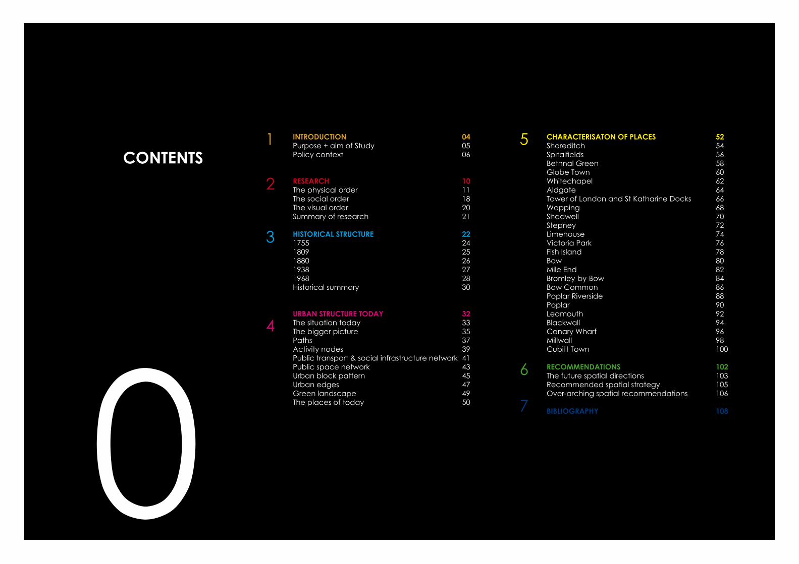
INtrODUctION 04Purpose + aim of Study 05Policy context 06
research 10The physical order 11The social order 18The visual order 20Summary of research 21
hIstOrIcal strUctUre 22 1755 241809 25 1880 261938 271968 28historical summary 30
UrbaN strUctUre tODaY 32The situation today 33The bigger picture 35Paths 37Activity nodes 39Public transport & social infrastructure network 41 Public space network 43Urban block pattern 45Urban edges 47Green landscape 49 The places of today 50
characterIsatON OF Places 52Shoreditch 54Spitalfields 56bethnal Green 58Globe Town 60Whitechapel 62Aldgate 64Tower of London and St Katharine Docks 66Wapping 68Shadwell 70Stepney 72Limehouse 74Victoria Park 76Fish Island 78bow 80Mile End 82bromley-by-bow 84bow Common 86Poplar Riverside 88Poplar 90Leamouth 92blackwall 94Canary Wharf 96Millwall 98Cubitt Town 100
recOMMeNDatIONs 102The future spatial directions 103Recommended spatial strategy 105Over-arching spatial recommendations 106
bIblIOGraPhY 108 70
cONteNts1
2
3
4
6
5
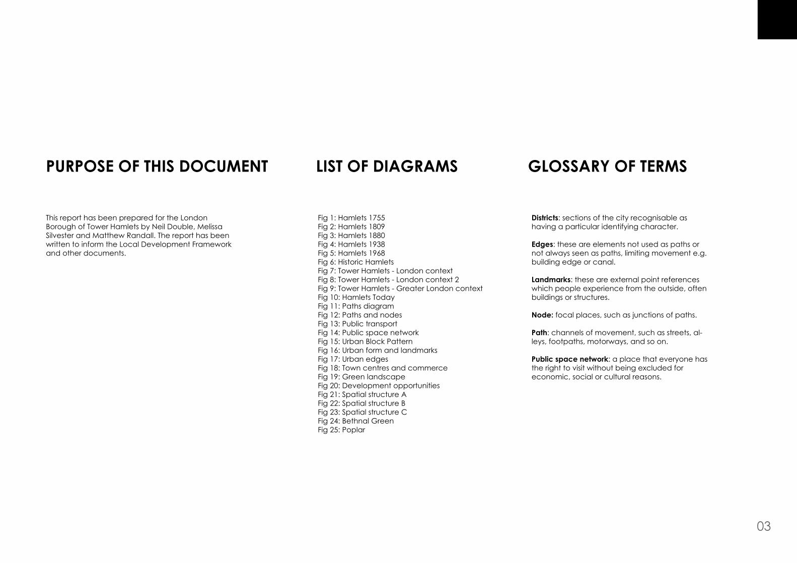
lIst OF DIaGraMs
Fig 1: hamlets 1755Fig 2: hamlets 1809Fig 3: hamlets 1880Fig 4: hamlets 1938Fig 5: hamlets 1968Fig 6: historic hamletsFig 7: Tower hamlets - London contextFig 8: Tower hamlets - London context 2Fig 9: Tower hamlets - Greater London contextFig 10: hamlets TodayFig 11: Paths diagramFig 12: Paths and nodesFig 13: Public transportFig 14: Public space networkFig 15: Urban block PatternFig 16: Urban form and landmarksFig 17: Urban edgesFig 18: Town centres and commerceFig 19: Green landscapeFig 20: Development opportunitiesFig 21: Spatial structure A Fig 22: Spatial structure bFig 23: Spatial structure CFig 24: bethnal GreenFig 25: Poplar
Districts: sections of the city recognisable as having a particular identifying character.
edges: these are elements not used as paths or not always seen as paths, limiting movement e.g. building edge or canal.
landmarks: these are external point references which people experience from the outside, often buildings or structures.
Node: focal places, such as junctions of paths.
Path: channels of movement, such as streets, al-leys, footpaths, motorways, and so on.
Public space network: a place that everyone has the right to visit without being excluded for economic, social or cultural reasons.
03
GlOssarY OF terMsPUrPOse OF thIs DOcUMeNt
This report has been prepared for the London borough of Tower hamlets by Neil Double, Melissa Silvester and Matthew Randall. The report has been written to inform the Local Development Framework and other documents.

041 INtrODUctION
INtrODUctION
INtrODUctION
05
background statement
Tower hamlets is an important and spatially unique inner-London borough, famous for its East End heritage, its vibrancy, and its multiculturalism. however, Tower hamlets is not without its challenges. Its spatial challenges, the growth agenda, widespread regeneration and the value of the built environment are eachofparticularsignificance.
Historicalgrowthhassignificantlyshapedthephysicalmorphology of Tower hamlets. The hamlets grew around key movement routes and connections between the East of England, the City of London and the Thames. Each hamlet was distinctive, having its own economic function, purpose and role to play, and eventually these hamlets began to merge together to form part of the greater London metropolis.
The connection to these distinctive places and their centres has been lost over the years since the Second World War. The function, variety and role of each place has gradually weakened, with their centres being dispersed, fragmented and loosened. This has had an impact on social cohesion and interaction and has contributed to the loss of a shared sense of place, a connection to our history, its distinctiveness and identity.
aim of study
To identify, analyse and characterise the spatial structure of the borough in order to help formulate future spatial planning recommendations.
study objective• To undertake a literature review, building a
knowledge framework to assist in analysis• To identify the historical growth of the borough since
1700 and build into this the knowledge framework• To perform a structural analysis of the borough based
upon this knowledge framework• To perform a brief characterisation of the places that
constitute the borough• To present a series of spatial planning
recommendations
study methodology
This study aims to identify, analyse and characterise the urban form and structure of the borough. by advocating an urban design led approach, a detailed understanding of the qualities and character of the borough can be presented.
Guidance from a number of key urban design sources has been used, including: Urban Design Compendium (1 and 2)1, By Design: Urban Design in the Planning System – Towards Better Practice2 and Towards an Urban Renaissance3. These key documents, alongside a wider literature review on urban structure, have informed a series of criteria that have been used to analyse the structure and form of the borough.
1 Urban Design Compendium 1 and 2, English Partnership and housing Corporation2 by Design: Urban Design in the Planning System – Towards better Practice: DETR3 Towards an Urban Renaissance, Urban Task Force
structure of study
Thestudyisdividedintoseveralchapters.Thefirstpartsets out background research into urban structure and public realm.
The second chapter sets out and analyses the historical growth of the borough and its impact on the image, shape and identity of Tower hamlets today.
The third chapter presents a present-day borough-wide analysis from a series of urban design perspectives, including movement routes and block pattern. This borough-wide analysis, alongside the historical analysis, provides a basis on which to present the places of today.
These places of today are then explored and analysed in brief, illustrated character assessments, setting out the historical and built processes that have come to form the townscape and identity of that place.
Chapterfivedrawstogetherallthepreviousanalysistopresent a series of recommendations for spatial planning in Tower hamlets.
This study provides part city analysis and part characterisation of the borough. It is rooted in an appreciation and understanding of urban design and how it can assist in creating locally distinct spatial planning. It is therefore not exhaustive in its scope, but is selective in its critique, appropriate to the needs of supporting the creation of a spatial Core Strategy DPD.

UrbaN strUctUre stUDY
POlIcY cONteXtNational Guidance
Using urban design as a tool to create high-quality, liveable, balanced communities has become a significantfactorinnationalgovernmentpolicyguidance – some of which is discussed below.
Planning Policy statement 1
PPS1 states that “good planning ensures that we get the right development, in the right place, at the right time”. This should form the components of a strategic, coherent planning framework.
One of the more relevant principles from PPS1 reminds us to ensure that “development supports existing communities and contributes to the creation of safe, sustainable, liveable and mixed communities with good access to jobs and key services for all members of the community”. Planning needs to recognise its role in helping creating places, communities that will stand the test of time, where people want to live, and which will enable people to meet their aspirations and their potential.
Local Development Frameworks need to provide a robust structure to assist in the creation of sustainable communities based upon a shared vision, and a clear strategy of how to achieve that vision. PPS1 states that:
“Good design should contribute positively to making places better for people. Design which is inappropriate in its context, or which fails to take the opportunities available for improving the character and quality of an area and the way it functions, should not be accepted.”
by Design: Urban Design in the Planning system – towards better Practice
This document placed urban design at the heart of the planning and development process, arguing that good design should be the aim of all those involved in the development process and should be encouraged everywhere.
It also placed a strong emphasis on “placemaking” – bringing together different actors and factors that influencethedevelopmentofplaceattheearlieststageof the process, in order to create places that work.
Thequalitiesofplacewereidentifiedas:• a place with its own identity • a place where public and private spaces are clearly
distinguished• a place with attractive and successful outdoor areas• a place that is easy to get to and move through• a place that has a clear image and is easy to
understand• a place that can change easily• a place with variety and choice
Urban Design compendium
This document expanded greatly upon By Design and provided detail and examples of a number of good urban design principles, it has shaped and guided developmentsignificantlysinceitwasproducedjointlyby English Partnerships and the housing Corporation.
It placed urban design and the tools and knowledge it yields at the forefront of making successful, thriving places across the different scales: from the detailed and local to the strategic.
“Urban design is about creating a vision for an area and then deploying the skills and resources to realise that vision”
Urban Design Compendium questions the success of modern post-war development, its failure to create great places, instead producing banal, monotonous development, humdrum in design and dominated by traffic.Ithighlightstheneedtoappreciatethecontextof areas in order to shape and develop local identity, and places that people value and feel proud of.Additionally, Urban Design Compendium makes strong reference to understanding and creating the urban structure, by which is meant...
06
INtrODUctION
“... the pattern or arrangement of development blocks, streets, buildings, open space and landscape which make up urban areas. It is the interrelationship between all these elements, rather than their particular characteristics that bond together to make a place.”
“Urban structure does not imply any particular kind of urbanism; it applies equally to the centre and to the suburb and everything in between; and of course it applies equally to the city, the town and the village.”
It linked the understanding and utilisation of urban structure to objectives or place qualities such as; • integration and connections• functionalefficiencyensuringindividualelements
worktogetheraspartofanefficientwhole• environmentharmonyensuringenergyefficientand
ecologically sensitive urban form• a sense of place that strengthens local identity• commercial viability responding to the realities of
marketinfluenceondevelopmentmixanddelivery
Understanding urban structure can allow the creation of a spatial framework that can guide, shape and direct development so that it contributes to, and works togetherinforming,anefficientwhole.
regional Guidance
The London Plan places great importance on design as a tool to achieve the high-quality environment demanded of a global city. Good design is central to all the objectives of the London Plan and the success of London as a whole. It is an essential ingredient in ensuring that higher densities and compact city living works long-term, and promotes sustainability, inclusiveness, health and well-being.
“London must achieve more intensive development in the right places. It must be designed and managed to ensure long-term efficient use, and in forms that are safe and sensitive both to their own operational needs and to their surroundings.”
“Design quality is central to this and poorly designed schemes will squander London’s valuable resources and can blight the lives of users and neighbours.”
Ensuring the right amount of development is located in the right places and designed to a high standard is a pivotal objective, and one which requires a strategic outlook.
The London Plan begins to identify the hierarchy of town centres across London in order to support the development of those town centres and guide the locationofretailandleisure.CanaryWharfisclassifiedas a major centre; Wentworth Street is part of Central Area Activities Zone; and the following are district centres: bethnal Green (3), Chrisp Street, Poplar, Roman Road (east), Watney Market, Whitechapel, Crossharbour.
The Mayor’s aim is to implement a polycentric strategy for London’s development by:• sustaining and enhancing the vitality and viability
of town centres, including community and civic activities and facilities.
• accommodating economic and housing growth throughintensificationandselectiveexpansion.
07

UrbaN strUctUre stUDY
sustainable community strategy
Much of the feedback from the Community Plan consultation has implications for the form and function of the borough, how we move around, and create places where people can meet others, feel safe, comfortable and enjoy themselves.
Identifying and analysing the urban structure affects and relates to the needs arising out of the community plan process. Some of the key points are:
• a need for common ground and space to meet people safe and lively streets
• reducing social exclusion• opportunities for everyday interaction• shared sense of place• a distinctive, local identity• access and liveliness of centres
how urban environments and their structures shape and influencetheabovequalitieswillbeexploredwithinthis study, as they directly affect the liveability of the borough and its neighbourhoods.
local Development Framework
Tower hamlets is set to build 31,500 new homes by 20161 and further growth is expected beyond this date asLondonfulfilsitspotentialasatrulyglobalcity.Thisrequires the borough to think carefully and strategically about becoming denser and more compact; making better use of its limited space; regenerating low-intensity industrial areas; its economic vitality and retail offer; and its infrastructure provision. In short, how to become a better place for people to want to live and work in.
The physical growth that is occurring, and will continue to occur, in Tower hamlets will have a real and physical impact upon the city. This change in the urban fabric will
1 London Plan 2008
have an impact upon society, as one cannot change without the other one also changing.
The Local Development Framework offers the council an opportunity to develop a clear, proactive, spatial vision and strategy for how the borough will look in 15 years, and identify means and ways to deliver its vision. Developing a robust understanding of the nature of the physical environment, its form and arrangement, and how it can improve people’s lives is an important consideration for a spatial strategy.
This report will therefore form part of a wider extensive research pool, which will inform and shape the emerging spatial vision and approach of the Core Strategy, the principal document of the Local Development Framework.
08

INtrODUctION
09

210
research
research
research
11
the PhYsIcal OrDer Urban structure and the living city
“Cities are large collections of buildings linked by space. Buildings represent economic, cultural, social and residential opportunities. Space connects them into a system of mutual accessibility.”
here, bill hillier describes the structure of cities. From this, it is clear that the elements of buildings and space are the fundamentals of urban structure. Intertwined with buildings and space opportunities, which all successful cities should offer. Opportunities can bring prosperity, choice, growth and a means to solve problems.
Urban design can be viewed as a way to look at parts and wholes, and how they combine to form places, good and bad. hillier suggests that the spatial form of cities, particularly their part/whole structure, may have been misunderstood in modern planning.
We have distinguished urban form from movement patterns, thinking that these entities can be neatly separated out and still form a coherent whole. hillier argues instead that movement powerfully shapes urban form and always has done. Most urban movement is what hillier calls “natural movement”, movement which is determined by the grid (the public-realm network) itselfratherthanbyspecificattractorsorgenerators.Thisis because all buildings create some sort and level of movement; they are all nodes in a sense. Therefore all movement is from somewhere to somewhere else. This creates a situation where most movement is “through movement”.
When street patterns create dead ends and cul-de-sacs and do not integrate into the wider movement network, we are seriously inhibiting this ‘through movement’. , which is so vital in ensuring legible, connected, and vibrant neighbourhoods and cities.
When such a connected system exists, which allows and encourages through movement from all places to all other places at all scales of movement, it creates the multiplier effect. This happens when the urban structure exploits the fact that all trips produce a by-product, in that each must pass through a certain number of intervening spaces. hillier argues that this can create patterns of natural co-presence which can be turned to economic, social and cultural advantage. For instance, people taking a certain route to the Tube will encourage shops and other commercial uses to locate along that route to take advantage of their purchasing power. This is a natural ordering law. This is what, in turn, creates urban life, activity, vibrancy and, over time, a sense of place.
“Disurbanism” has created dead environments where bits have been separated out to the point where they don’t interact, and fail to generate any activity and vibrancy in the city. buildings sitting in space – a typology often found with much post-war housing – are so disconnected from the public realm that they can no longer form the vital edge of activity, entrance and surveillance, with natural implications on perceptions of safety. Such development types are concerned disproportionately with internal layout and do not consider the relationship with internal and external structure,andhowitfitsintothecityfabric.
The deformed grid structure, or the “deformed wheel” as hillier refers to it, was the generic structure of London: different to (not better or worse than) the grand, planned boulevards of Paris, and the unique grid pattern of l’Eixample in barcelona. This gave London its unique “big city” feel, but also its local sense of place, arising from all the little hamlets and villages that eventually merged. This to some extent has been lost in east London due to modern, post-war developments failing to integrate with this deformed grid structure.
“Good urban space is used space. Most urban space is movement. Most movement is through-movement, the by-product of how the grid offers routes from everywhere to everywhere else in the grid. Most informal space is movement-related, as in the sense and fact of urban safety.”
Understanding, and designing the city’s urban structure in order to make connections is fundamental to the life and vibrancy of the city, and the success of urban neighbourhoods. When done correctly, a connected street system can bring the whole system of land uses, densities, building heights, active public spaces, and town centres into a structure that maximises opportunities, everyday interaction, and economic prosperity.

UrbaN strUctUre stUDY
“In a living city, different types of urban systems overlap to build up urban complexity”
This layering and overlapping of systems can be witnessed in successful urban areas, with local shops, workshopspaces,greenparks,streets,busstops,offices,Tube stations, and housing co-dependent on each other, as each operates as a particular type of node, creating and attracting movement.
“Coherent city form emerges from assembling components hierarchically, using intense local couplings together with long-range connections that reduce disorder... urban coherence can only come about from the correct combination of geometry and connectivity.”
The Urban Task Force highlights how important good urban design is to the success and functioning of the city, its districts and for citizens’ quality of life. The physical environment can provide the positive framework on which other social, economic and civic functions come together to make a place feel alive, vibrant, successful and self-sustaining.
“Well-designed urban districts and neighbourhoods succeed because they recognise the primary importance of the public realm – the network of spaces between buildings that determine the layout, form and connectivity of the city. The shape of public spaces and the way they link together are essential to the cohesion of urban neighbourhoods and communities. When the framework is well designed and integrated – as in the traditional compact city – it plays a fundamental role in linking people and places together. When it is fragmented and unstructured – as in so many modern urban environments – to contributes to social segregation and alienation”
We as city dwellers know instinctively when a place feels good, safe, comfortable, and lively and makes us want to stay and enjoy it – and we know when a place does the opposite. Urban design should be used not as an abstract aesthetic tool, but as a way to improve people’s lives and their urban experience.
Nikos Salingaros argues that there is a need to understand the city as a complex interacting system with hierarchical components that combine to form its structure; only by doing this can we begin to reinstate some sort of urban spatial structure.
“A living city differs radically from what we have built in the twentieth century”
A living city, one that is full of vibrancy and vitality, depends upon an enormous number of different paths and connections.
Salingaros refers to something termed the Urban Web, which links very strongly to hillier’s concept of the wheel like grid structure.
Salingaros discusses the inverse-power scaling law, saying there should be only a few components of large scale, several of intermediate scale, and very many of small size. As humans our minds automatically scale our environment. We recognise what feels natural by its scaling hierarchy and react accordingly.
12

research
Therearesomeverydefiniteurbanqualitieswhich,when combined successfully, can help to achieve a successful urban street, quarter, district etc. These have been outlined in various books, reports and best-practice guidance, and are summarised below:
• a sense of character and identity• continuity and enclosure – clear distinction between
public and private • a successful and attractive public realm• ease of movement • a place that has a clear image and can be easily
understood and navigated• a place that can change and adapt easily• a place with variety and a high level of choice
Urban Structure can be described as the framework of routes and spaces that connect locally and more widely, and the way developments, routes and open spaces relate to one other. The layout provides the basic plan on which all other aspects of the form and usesofdevelopmentfittogether.Inotherwords,itishowthe bits of a city can and should be put together to form a liveable, safe, lively, and enjoyable place.
“So first come urban life (routes), then space (public realm) and lastly buildings (form).”Jan Gehl, urban designer
Understanding pedestrian movement patterns and how the built form shapes those patterns is therefore important, as is how the quality of space encourages or hinders pedestrian life and movement. It is very much about activity and accessibility.
There is an important inter-relationship between these elements. When combined successfully they can enliven our urban experience making places understandable, coherent and vibrant.
how this understanding can be applied to analysing the urban structure that we experience in Tower hamlets will form part of chapter four.
Creating opportunities for higher levels of urban intensity in appropriate locations can be an important step towards delivering an urban renaissance. Often space is under-used, poorly watched, and as a result, perceived as unsafe. Increasing the intensity with which this space is used should be a clear objective. Transport hubs and urban centres are examples of where this can be achieved, along with key movement routes.
13
UrbaN strUctUre stUDY
Generating activity
Accessible places, ones which are easy to understand and move around are only valuable if there is a reason for people to move around. hence, uses and activities play an equally important role.
An approach to mixing uses is an important step in creating viable, robust and thriving places. A variety of uses encourages different people, at different times, for a variety of reasons, to use, enjoy and spend money in a place.
“Many activities can – with careful design and good urban management – live harmoniously side by side. Except for certain industries or activities that attract very high traffic volumes or create noise at unsociable hours, most businesses and services can co-exist with housing.”
Mixing at the right scales is important, from the street, to the block, to the neighbourhood, to the district, to the major centres. Achieving this optimum mix is a careful balancing act and one which needs to be explored on a place-by-place basis.
The greatest mix of uses should occur in the most accessible locations – close to public transport facilities, easy to get on foot and bike; centres with higher densities; landmarks; and meeting places for all kinds of people.
having a diverse range of small shops, services, markets, art galleries and other unique, local uses is one of the main attractionsandbenefitsofcityliving.Asdensitiesincrease and more people live in a certain area, the greater the viability for a diverse mix of uses. More people equals more spending power and greater desire for choice.
The social mix of the population is a related issue. A good mix of incomes and tenures ensures that centres can thrive. There can be a healthier distribution of wealth within a place, spending can be recycled and transferred within a place, rather than having only high-income or low-income households in an area.
Variety and diversity in the city is a central factor in creating successful neighbourhoods, and one which Jane Jacobs expressed in her analysis of city neighbourhoods in America:
“...the fact is big cities are natural generators of diversity and prolific incubators of new enterprises and ideas of all kinds. Moreover, big cities are the natural economic homes of immense numbers and ranges of small enterprises.”
The complex variety and mix of activity that naturally occurs in cities is what makes them so inviting for large numbers of people. The city is more than just for living; it is the meeting point for different people.
The quote below criticises modern planning techniques of separating functions and uses of the city into neat, simple parcels and its creation of dead, soulless and boring places:
“Perhaps the city was not after all, an assembly of well planned housing units, but something that required a different kind of inquiry.”The Seduction of Place, Joseph Rykwert
14
research
centres of activity
highly accessible urban centres of great variety and diversity, located in and around public-transport nodes, can offer real choice and opportunities for interaction. They should be clearly accessible by foot to ensure social inclusiveness.
“The purpose of promoting variety is to increase choice. But choice also depends on mobility: people who are highly mobile can take advantage of a variety of activities even if these are spread over a wide area.”(Bill Hillier)
If we are to achieve real social inclusiveness then we need variety close to people – within walking distance. Otherwise people without high mobility are going to remain socially, physically and economically isolated. These people include:
•children•poorpeople•disabledandsickpeople•elderlypeople•parentswithyoungchildren•peoplewithoutcars•peoplewithoutlocalknowledge
As a rule of thumb people should be able to easily access a network of different centres of different sizes offering a wide variety of choice, opportunities and uses.
•local: 100-250 metres – your local corner shop, pub, dry cleaners, takeaway, etc, perhaps located on the groundfloorofacornerbuilding
•Neighbourhood:250-500metresorfiveminutes’walk
•District: 500-1,500 metres or 10 minutes’ walk – restaurants,shops,offices,workspaces,cafés,libraries •Major: 1,500-4,000 metres or 20 minutes’ walk –extensivevarietyofshops,restaurants,offices
•city: access to the entire metropolis – theatres, venues, specialist providers, famous department stores
The above is meant to be a rough guide, as different centres have different functions and uses and often change, overlap, grow and shrink to suit social and economic circumstances. Centres also do not sit in isolation, they interconnect and overlap, they support one another, and thus they need to be understood as such.
Access to a number of centres is an important thing for local people, they want to feel belonging to their neighbourhood and have access to a wide range ofshops,servicesandotherthingsyoucanfindina modern city like London. Interconnection is vital between centres, to encourage a walkable urban environment, and for people to be able to appreciate the scale and hierarchy of centres.
Things that can limit the walkability of a place:
•streetsthataredominatedbycars
•poorquality,clutteredanddirtypublicrealm
•poorlegibility–easytogetlost,difficulttofindyourway round
•poorpermeability–disconnectedstreetnetwork,suchas dead ends and cul-de-sacs
All these elements in isolation or in combination can restrict a person’s ability to reach the centre of their choice, having a knock-on effect on commercial vitality, opportunities for interaction, and the sense of community.
15
UrbaN strUctUre stUDY
the public space network and social interaction
The street network should allow people to move from where they are to where they want to go. It should allow them to do this in a multitude of ways.
The public realm can be described as the space between buildings, the space where urban dwellers come together.
“The public realm is a place for all people, regardless of ethnic background, age, socio-economic class, disability, religion, or the like. Residents, visitors, students, workers, children, and the elderly must all be invited to meet in the public realm!”(Urban Task Force)
Dividing different types of open space into individual units only serves to isolate activities, not only from each another, but from the movement routes that make them viable, active, dynamic and safe places. Often the public realm we experience is dead, unloved, and poorly connected, with little or no natural surveillance, severely limiting its potential as a meeting place for local people.
“Some urban areas have too much public space, much of which is poorly designed, managed and maintained. Many 20th-century residential developments have a public realm which is simply ‘SLOAP’ (Space left over after planning) – soulless, undefined places, poorly landscaped, with no
relationship to surrounding buildings.”(Urban Task Force)
The Urban Task Force has clearly recommended an integrated, over-arching, spatial approach.
“Public space should be conceived of as an outdoor room within a neighbourhood, somewhere to relax and enjoy the urban experience, a venue for a range of different activities, from outdoor eating to street entertainment, from sport and play areas to a venue for civic or political functions; and most importantly of all as a place for walking or sitting-out.”(Urban Task Force)
In order to make streets and spaces attractive for people to use and stay in, they have to be of exceptional quality and based on pedestrian scale. Often, quantity is given precedence over quality, resulting in large amounts of under-used, unattractive and unsafe open space that fails to add value to local people. This can be seen in many post-war housing estates.
Creating a quality environment for people is paramount and must be considered before anything else in order to achieve a lively and sustainable public realm.
“There are two main methods of categorising squares – by function and by form. There are numerous examples of recent plaza design where one or other of these two equally important criteria of excellence have been neglected. The empty windswept place surrounded by under-utilised buildings is all too common in the modern city, while its opposite or counterpart, the busy traffic
island or faceless car park around which are scattered collections of non-related buildings, is also endemic in the urban scene.”C. Moughtin and M. Mertens, ‘Street and Square’
Jan Gehl, through much of his research, argues for a clear, people-based approach to spatial strategies.
Firstly, he states the need to establish the human dimensions: where people move and why; where they want to stop and why; and the complexity of interactions in the public realm. This then goes to shape the public-realm network of streets and space, which in turn dictates and shapes the urban form and arrangement of buildings. This is needed to ensure that the relationship between people and buildings supports public life and animation.
Gehl has been critical of modern post-war planning and architecture for failing to understand the physiological needs and wants of urban citizens – the reason we all come together. but he also states that:
“They had good intentions. From the 1930s, the prevailing wisdom in planning was that it was healthier to take people out of the cramped conditions of the city and house them away from workplaces, in multi-storey structures (to ensure healthy cross-breezes) which were clean and sun-facing
But they neglected the psychological and social aspects of design, so we ended up with the blank, isolating tower blocks that blight cities all over the world. As Gehl puts it, they literally built life out.”(Jan Gehl)
16
research
Gehlrecentlydefinedthenotionofthe“invadedcity”, where cars, inhospitable developments, and the sidelining of pedestrians have created an urban environment where people would rather not be turning them into “abandoned cities” so unpleasant, boring and inhospitable that no one lingers in the streets and squares than is absolutely necessary.
Gehl states that there are three types of outdoor activities: •Necessary: includes those that are more or less compulsory – going to work, school, the shops, waiting for a bus, etc. These are generally everyday tasks the majority of people need to partake in to some extent, regardless of the conditions and external environment.
•Optional: these are activities which occur if there is a wish to do so, and the environment and place make it possible and pleasurable to do so.
•social:theseoccurwhentherearesufficientoptionalactivities to generate enough people, as these activities require other people to be in close proximity. Wanting to be around other people in a pleasant environment – hearing, seeing, playing, chatting, people-watching and other passive contacts is a characteristic of
a successful public space. It offers the chance for spontaneous interaction, chance meetings, informal chats, communal activities, and can entice more people who just want to be around other people in a safe, pleasant, comfortable and stimulating environment: the epitome of city living. Successful places will allow optional and social activities to occur in highest frequency. When the public realm and exterior environment are of a hostile, harsh, unfriendly, poorly maintained nature, then these higher-end social interactions will not occur - at least not to a great extent.
There is a strong interrelationship between the quality of a city’s public realm and the quantity of the positive social interactions that occur.
“Safe, well maintained, attractive and uncluttered public spaces provide the vital ‘glue’ between buildings, and play a crucial role in strengthening communities.”Jjan Gehl)
“Where do people go?” is a question we should be asking ourselves constantly, as without this understanding, development strategies and frameworks may be focusing the wrong development in the wrong place – as has often been the case with modern development.
17
the sOcIal OrDer
UrbaN strUctUre stUDY
•Placeisalwayschanging.City planning and designing is invariably about recognising directions and rates of change.
•Butintheend,natureandglobalchangeswillprevailover all. Less than 10,000 years ago, London’s River Thames was a tributary of the Rhine and the UK was not an island. Climate change and changing sea levels have been, and will be, the norm.
If in Tower hamlets the Community Plan is indeed looking at “community” then the Core Strategy needs to understand and look at “place” as an urban manifestation. Places are real and experienced areas of urban geography and there is a need to understand urban change on the smaller, neighbourhood level from which the community understand and experience it.
Place Identity
“Place identity is the connection and relationship that exists between people and place over time.”Professor Ian Bennett
The temporal element is often overlooked. It takes years and decades for a place to develop and gain identity from its users.
Collective memory of place is important. It connects people to the place in which they live, to its history, and the people who have helped develop the place over the years. This is particularly true of the East End which has a very strong sense of itself, its history, its past citizens and its civic growth. Exploiting this facet is a key element of developing and strengthening a sense of place.
concept of place and community
Place has six key components according to Terry Farrell:
•Thereisforhumansageneric,inherentsenseofplacefor all places
•Buturbandesignandplacemakingcanonlydealwithplaceinspecific,notutopianterms.Analysis of existing form, its history and context and what makes the place what it uniquely is, is the starting point. Place can be seen as culture frozen in time.
•Placeisalwaysasilentclientandoftenthebestclueiswhat it “wants to be”
•Mono-culturalentitieslikeshoppingcentres,hospitalsand airports are kinds of half-places; but they invariably revert to the natural DNA of human places: diversifying and layering with shopping, chapels, housing etc, and becoming structured with a hierarchy of streets and squares.
18

research
“Memory of place does not mean rebuilding the past, but drawing on its memory to rediscover the paths and footsteps of past generations, guided by topography and the weather which traced the early structure of the city. It also means that in renewing the city for the present and the future we must create places that will strike new memories for the next generations.”MBK Architects
Memory and meaning informs the creation of a place, an image of a place, what constitutes it, where its boundaries lie, where its edges are, where its centre lies.
The built form of cities should be designed to encourage its users to develop a sense of:
•empowerment•rootedness•transculturality•onenesswithnature
Producing an urban environment which engenders positive connotations and meanings requires citizens to develop an attachment. This is an important step in the creation of neighbourhood well-being.
19
the vIsUal OrDer
UrbaN strUctUre stUDY
edges
Edges are linear elements, not considered paths by the observer – a wall or railway line, for instance. Such edges may be barriers to movement but they may also be seam lines which two regions are related and joined together, such as a canal perhaps. Although not as important as paths, they are important organising features for citizens.
District
These are the medium to large sections of the city, normally considered to be of two-dimensional extent, which observersdefinethemselvesasbeing“insideof”or“outsideof”.Theyhavesomecommonoridentifiablecharacter, which causes the observer to think of it as a place.
Nodes
Nodes are the strategic spots in a city into which an observer can enter. These are the intensive foci to and from which he or she is travelling. They are often formed by the crossing or convergence of paths, a transportation stop, or concentrations of activity related to some use or physical character, such as a market or public square. Nodes, or their wider role as forming centres, are typically the intensive foci of the district in which they sit. They are often the dominant feature for the observer, viewed often as the heart of a place.
landmarks
Landmarks are a point-reference. They are usually a physical object such as a building, sign, shop or mountain. They are singled out as one element within many elements. They may be distant, strategic landmarks seen from many places, like a tower or dome, or, locally, they may be more visible from a certain angle in the street, such as a pub on a corner.
reading the urban environment
Each piece of city has a level of clarity or “legibility”, which means the ease with which its parts can be recognised and be organised into a coherent pattern.
Kevin Lynch suggests we need to begin developing a clear and comprehensive image of the city, one which is coherent and legible. This has direct implications for urban form and the role it plays in creating a wider pieceofcity.Thisenvironmentshouldreflectthecitizenswho live there; it should hold meaning and be symbolic; it should promote civility and cohesion as well as allow ease of movement, multiple use and order.
The places that make up a city need to be imagined and read as well-knit, altogether remarkable pieces of city, connected into the whole, yet rich in local history, meaning and tradition. This is what creates the ever elusive desire for “sense of place”.
character, richness and distinctiveness
It should be noted that the city is a product of many builders.Itisconstantlyinflux,beingrebuiltastimepasses.Andthereisnofinalresult,justadirectionthatcan be promoted.
A successful piece of city, therefore, manages to conserveitsurbanformandshapeandhassignificantvalue that people have embedded meaning and affection into. This is what builds up a place’s character and distinctiveness.
There needs to be a reconnection to the art of shaping cities, to create a form that promotes sustainable living and well-being on a neighbourhood level. Creating a city form that is legible and coherent is a crucial condition for the enjoyment and use of the city, as well as its desirability as a place to live.
When we experience the city we use all our senses, and the image we get is a result of all these senses forming a picture, whether bad or good. Legibility of the city is a crucial element in making places more enjoyable and successful. An image is composed of three components; structure, identity and meaning. These all come together to form a clear or unclear image.
Image quality
Understanding the parts that combine to form the cityscape of Tower hamlets is an important output of this study. Citizens make sense of their neighbourhood, whether it is bethnal Green or bow. They know the best ways to get around. but for people who are not so familiar with an area, its legibility is an important component of its ease of use and enjoyment. Getting lost in a place is rarely an enjoyable experience.
A clear, vivid and integrated physical setting produces a coherent image for the citizens and encourages social life too. It encourages people to use their environment, to move around on foot. People feel comfortable and connected and are more likely to spend time on their streets and spaces. Places may be organised around a set of focal points, and named regions, or linked via remembered routes. These elements build an image.
Therearefiveprincipalphysicalelementsthatcontributeto creating a city image:
Paths
Paths are the channels along which the observer customarily, occasionally, or potentially moves. These are the predominant elements in their image. They form the majority of the cityscape. They observe the city while moving along these paths, and along the the other environmental elements are arranged and related.
20

research
The knowledge and understanding of the qualities and components of urban structure can be taken forward in order to use as an analysis base.
From all the research undertaken, the following conclusions can be drawn:
•Thepathsthatallowmovementareakeylayerin understanding the quality of a particular urban structure.
•Thatactivitynodesarecreatedprimarilybythe crossing of paths: the more connected the paths, the more intense the activity node.
•Theseactivitynodesareplaceswheremostpeoplemeet in the city. They are the convergence of pedestrian movement and, as a result, activities such as commerce, shops, etc., locate in such places due to the high footfall and increased prospect of sales.
•Activitynodesinmoderncitieshavealsobeen created where public transport stations or a cluster of buses are located, as these create a great deal of movement.
•Thateverypieceofmovementinthecityisthroughmovement. To go from one place to another, you have to go via many other places, hence the importance of a connected, understandable street network. This implies the connection between activity nodes are equally important as the activity nodes themselves.
•Thatthequalityofthepublicrealmhasconsiderableimpactandinfluenceonthequantityofsocial interaction and the quality. here, there is a spectrum that operates.
•Thattomaximisesocial-interactionopportunities,youneed to have activities, and therefore people. This, in turn, generates more people and more activity, which encourages social activities to take place, which has a direct link with “sense of community” and “social inclusion”.
•Thatanidentityforaplacecanonlybesuccessfullydeveloped when you assist in developing the connections between people and a place over time. buildings, and the activities that occur within them, play a key part in developing a sense of place.
•Thatcentreshelptofosterasenseidentitywithinaplace. They can form the heart of a place, where citizens can meet. but there has to be a reason to be there. There has to be many activities occurring within a high-quality public realm.
•Theidentityofplacesisheldwithinitsbuildingsandstructures, hence there is a need to preserve and reuse the building stock that is valued and liked by local people.
•Thatthepublicrealmshouldbeconsideredasan outdoor living room, a place where social interaction and activities can occur – from chatting on the pavement to a street event.
sUMMarY OF research
21
3 hIstOrIcal strUctUre
22
hIstOrIcal strUctUre Urban structure over time
Exploring the historical structure of Tower hamlets from the 16th century through to the present day allows a story of urban structure to form.
This story is an important link between place identity, historical associations and the role and success of neighbourhoods in Tower hamlets today. Settlements have history; they have grown and have been formed over many years, by many hands, which contributes to our understanding of urban structure and place identity.
Why is it important?
Understanding the processes that have shaped and created the settlements and urban form over the years is an important step towards understanding urban structure. Structure comes about by many processes, over many years. Taking a chronological approach allows a deeper understanding of where we are today.
You begin to see the key movement routes that have shaped the accessibility of the borough over the years. Some routes have remained constant and important over hundreds of years, and remain our main thoroughfares. how we understand these routes is important in how we plan for them in the future.
the layers of historical development
The years that are presented cover the period from 1755 to present day, which covers a snapshot of the recent historical development of the borough. however, it should be noted that Tower hamlets has a long history of settlement, of which this analysis only begins to scratch the surface.
“Tower Hamlets has been inhabited for 2,000 years, with a detailed history going back to the Roman invasion of AD43. Developed on marshlands, Tower Hamlets grew from a small cluster of communities, known as the hamlets around the tower – which is the origin of the borough’s name – into the vibrant and dynamic borough of today.”www.towerhamlets.gov.uk
hIstOrIcal GrOWth
23
Crown Copyright. All Rights reserved. London borough of Tower hamlets 100019288 2009
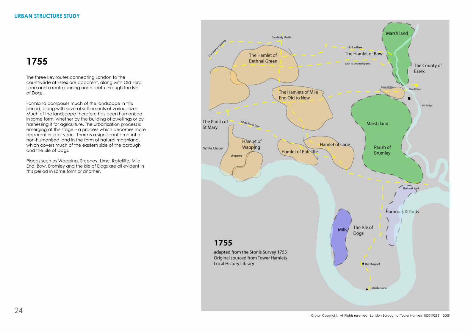
1755
UrbaN strUctUre stUDY
The three key routes connecting London to the countryside of Essex are apparent, along with Old Ford Lane and a route running north-south through the Isle of Dogs.
Farmland composes much of the landscape in this period, along with several settlements of various sizes. Much of the landscape therefore has been humanised in some form, whether by the building of dwellings or by harnessing it for agriculture. The urbanisation process is emerging at this stage – a process which becomes more apparentinlateryears.Thereisasignificantamountofnon-humanised land in the form of natural marshland, which covers much of the eastern side of the borough and the Isle of Dogs.
Places such as Wapping, Stepney, Lime, Ratcliffe, Mile End, bow, bromley and the Isle of Dogs are all evident in this period in some form or another.
24
Crown Copyright. All Rights reserved. London borough of Tower hamlets 100019288 2009
hIstOrIcal GrOWth
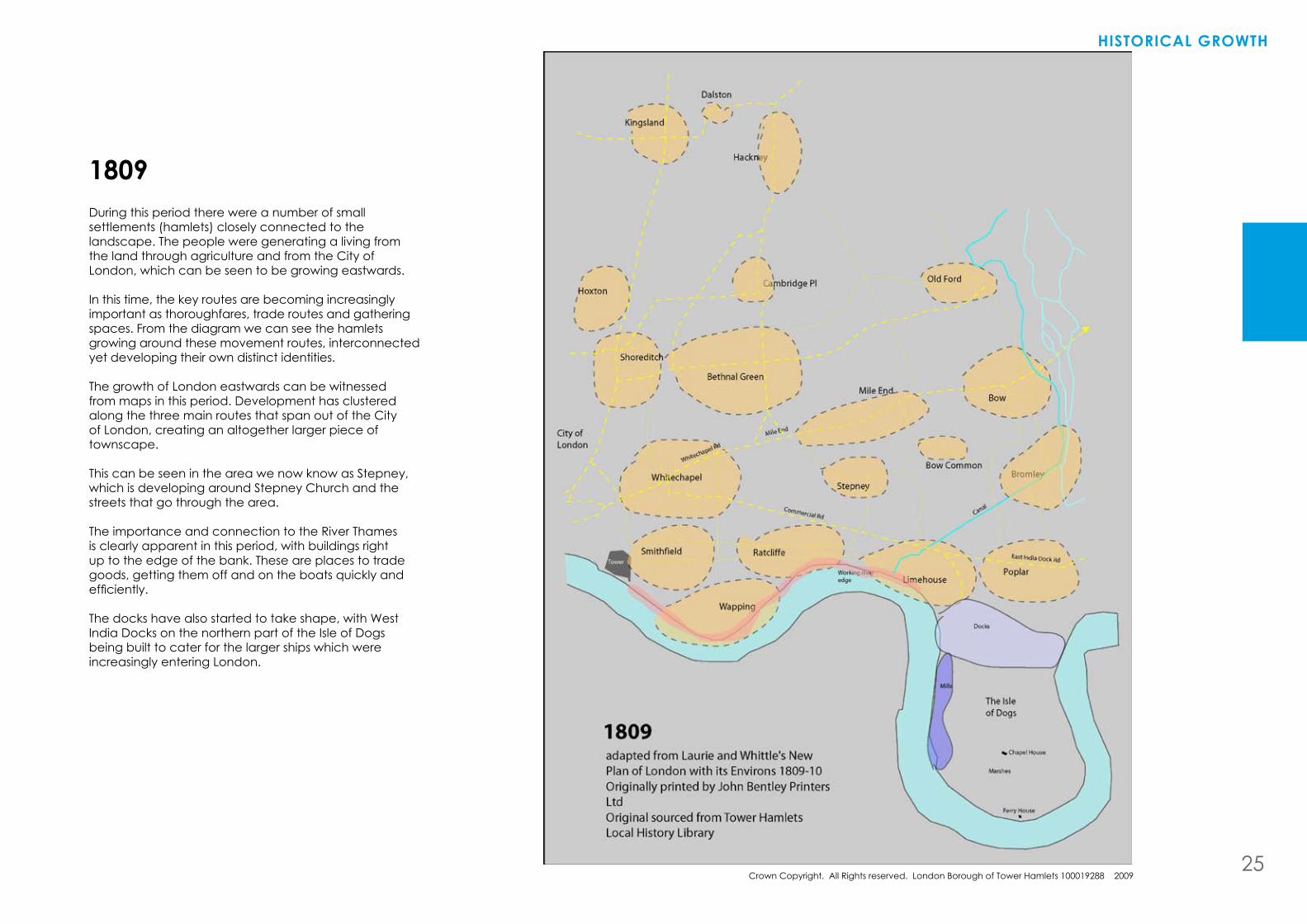
During this period there were a number of small settlements (hamlets) closely connected to the landscape. The people were generating a living from the land through agriculture and from the City of London, which can be seen to be growing eastwards.
In this time, the key routes are becoming increasingly important as thoroughfares, trade routes and gathering spaces. From the diagram we can see the hamlets growing around these movement routes, interconnected yet developing their own distinct identities.
The growth of London eastwards can be witnessed from maps in this period. Development has clustered along the three main routes that span out of the City of London, creating an altogether larger piece of townscape.
This can be seen in the area we now know as Stepney, which is developing around Stepney Church and the streets that go through the area.
The importance and connection to the River Thames is clearly apparent in this period, with buildings right up to the edge of the bank. These are places to trade goods, getting them off and on the boats quickly and efficiently.
The docks have also started to take shape, with West India Docks on the northern part of the Isle of Dogs being built to cater for the larger ships which were increasingly entering London.
1809
25
Crown Copyright. All Rights reserved. London borough of Tower hamlets 100019288 2009
UrbaN strUctUre stUDY
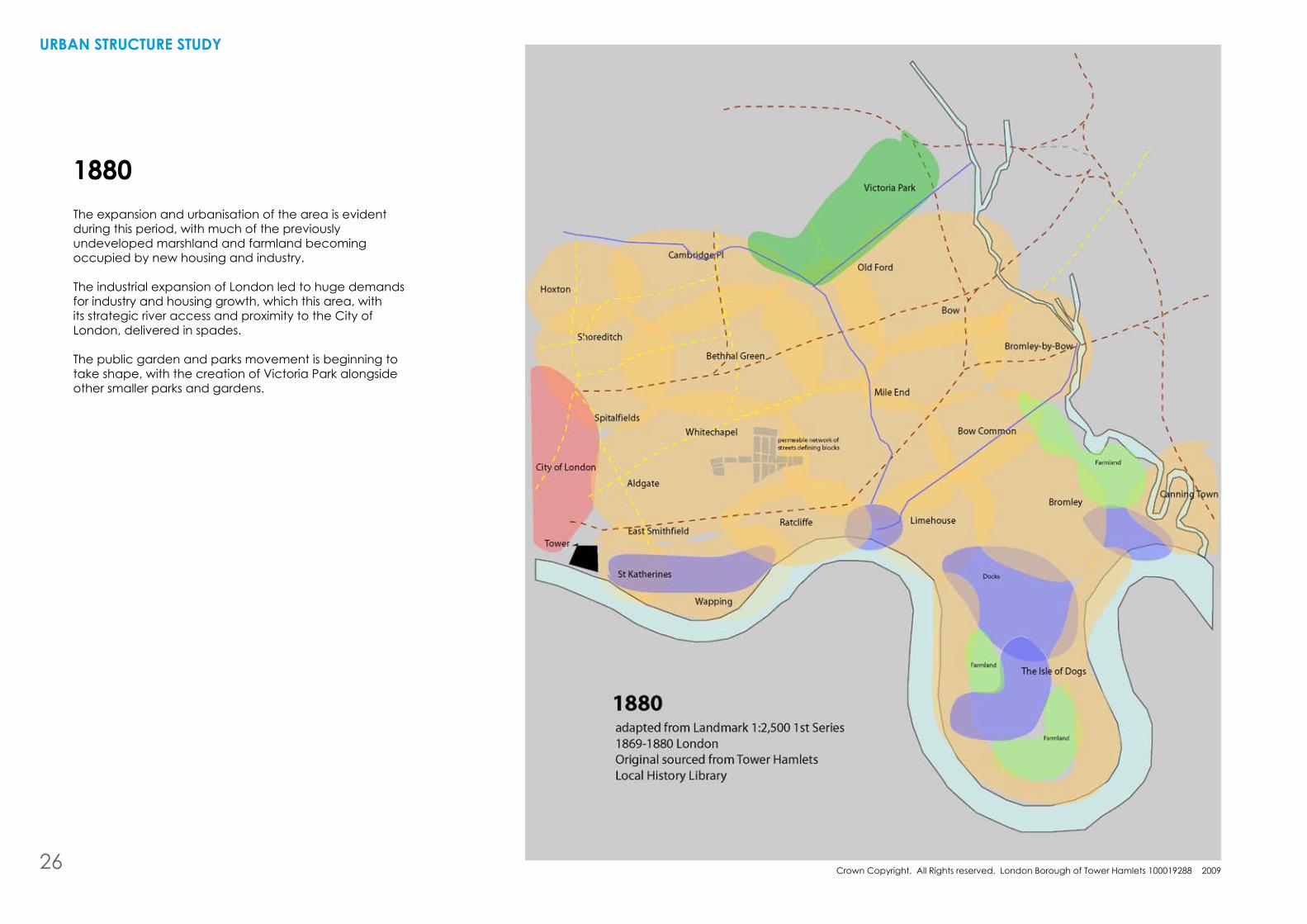
1880The expansion and urbanisation of the area is evident during this period, with much of the previously undeveloped marshland and farmland becoming occupied by new housing and industry.
The industrial expansion of London led to huge demands for industry and housing growth, which this area, with its strategic river access and proximity to the City of London, delivered in spades.
The public garden and parks movement is beginning to take shape, with the creation of Victoria Park alongside other smaller parks and gardens.
26
Crown Copyright. All Rights reserved. London borough of Tower hamlets 100019288 2009
hIstOrIcal GrOWth
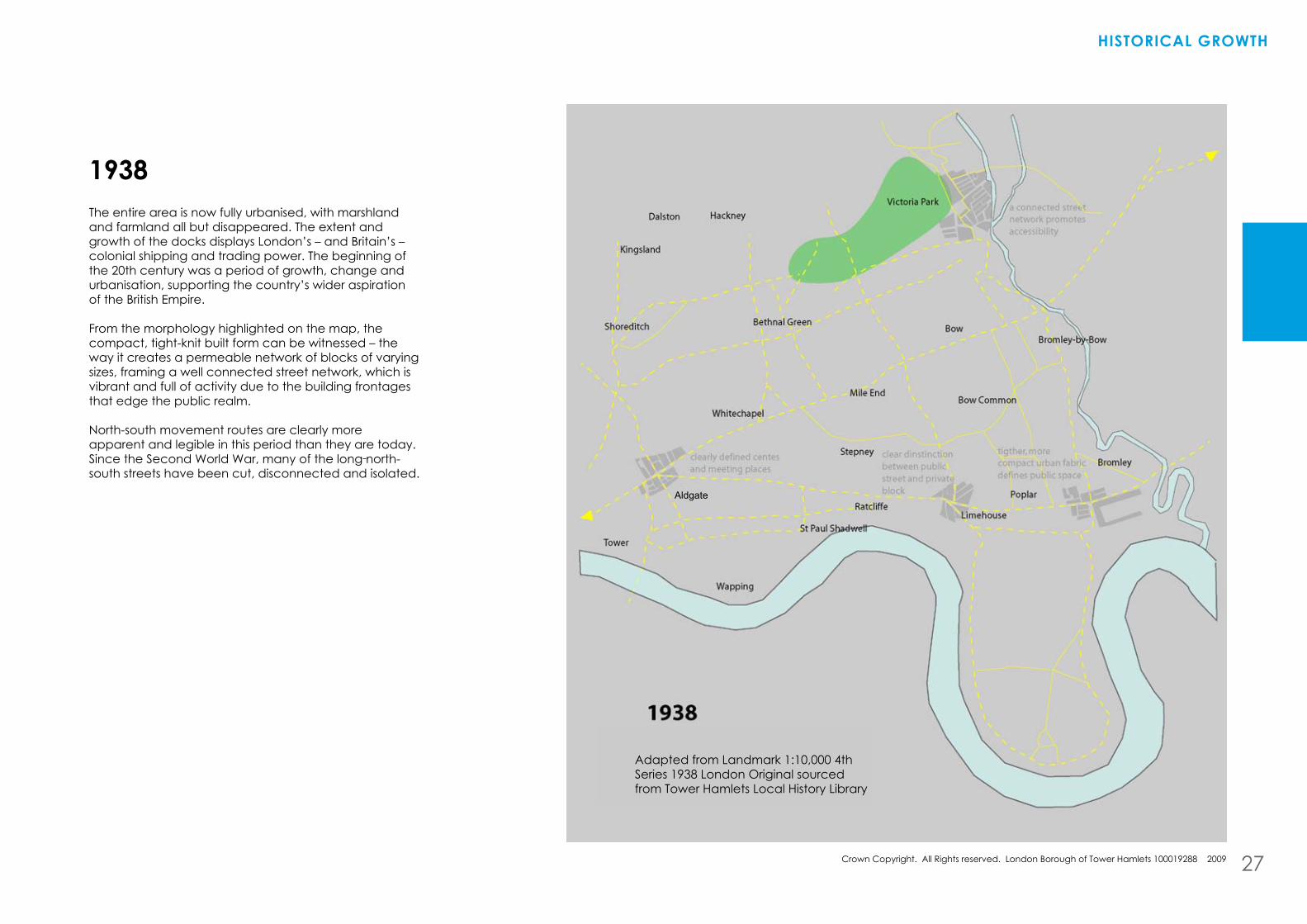
The entire area is now fully urbanised, with marshland and farmland all but disappeared. The extent and growth of the docks displays London’s – and britain’s – colonial shipping and trading power. The beginning of the 20th century was a period of growth, change and urbanisation, supporting the country’s wider aspiration of the british Empire.
From the morphology highlighted on the map, the compact, tight-knit built form can be witnessed – the way it creates a permeable network of blocks of varying sizes, framing a well connected street network, which is vibrant and full of activity due to the building frontages that edge the public realm.
North-south movement routes are clearly more apparent and legible in this period than they are today. Since the Second World War, many of the long north-south streets have been cut, disconnected and isolated.
1938
27
Aldgate
Adapted from Landmark 1:10,000 4thSeries 1938 London Original sourced from Tower hamlets Local history Library
Crown Copyright. All Rights reserved. London borough of Tower hamlets 100019288 2009
UrbaN strUctUre stUDY
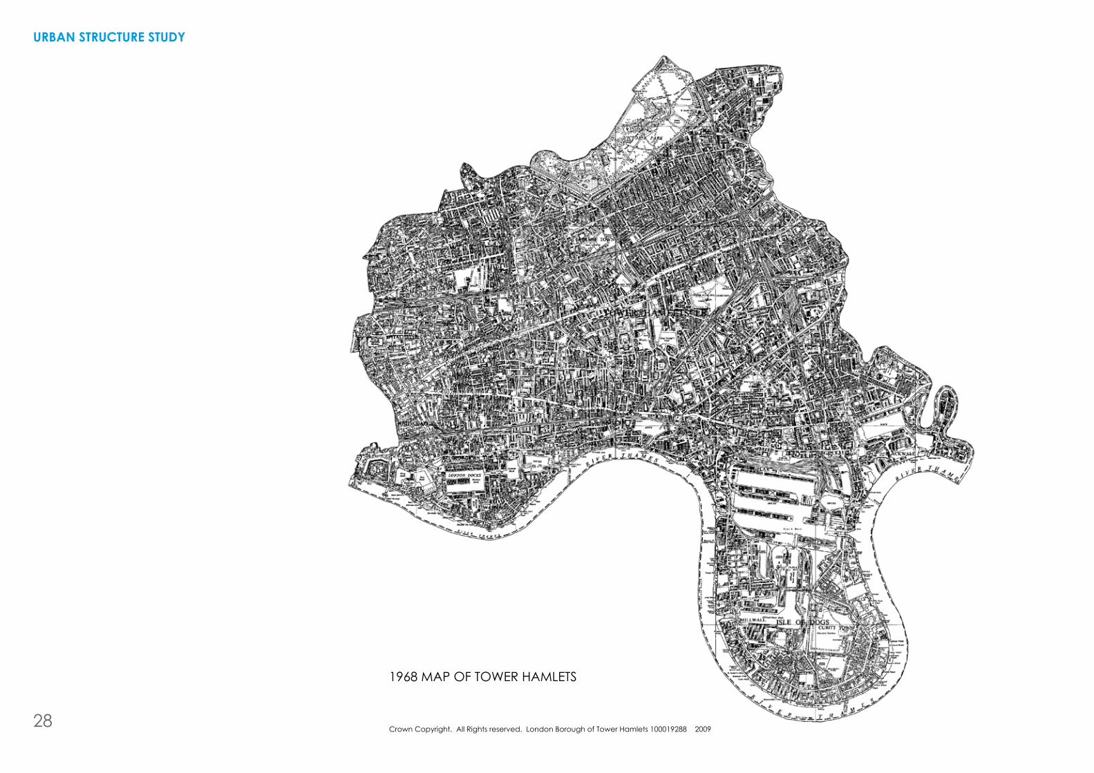
1968 MAP OF TOWER hAMLETS
28
hIstOrIcal GrOWth
During this period a great deal of post-war redevelopment had either been undertaken or was about to be undertaken. The urban landscape and structureoftheboroughwaschangingsignificantlywitha new development typology.
Thestructureofthepathnetworkwassignificantlyaltered with the comprehensive redevelopment projects andhousingestates.Traditionalstreetsflankedbyterraced housing were being replaced, in many areas, by modernist housing estates, characterised by towers and long horizontal slab blocks. These were surrounded by open space and criss-crossed by footpaths, and were beginning to radically change the urban structure of this part of the East End.
Many of the paths that cross through these estates are not seen or read as public streets, and as a result are rarely used by the general public, who prefer to go around the estates using the traditional street network that remains.
Post-war redevelopment also led to depopulation and ade-intensificationoflanduses. housing estates were built at densities much lower than the housing that they replaced. Many of these estates turned their backs on the street network, which was becoming more and moredominatedbytraffic.Theoncecloserelationshipbetween residents and their street was being lost. Retail and commerce was often provided within these estates, detached from the wider street and movement network. This discouraged passing trade, and many of these clusters of shops and services failed to thrive due to a lack of trade.
Also during this time, the docks were starting to suffer from larger container ports, and due to the changing nature of shipping, the docks and River Thames became too small for the ever increasing ship sizes. This led to rising unemployment and, some years later, to the eventual closure of the docks, which meant not only loss of livelihood for local people, but contributed to the removal of identity and sense of place in these neighbourhoods.
bromley had a recognisable identity during this time. This, though, has been lost in recent years as large motorways have been ploughed through the area. It has lost its position and place identity. The same can be said for bow Common, where a process of urban-form loosening,de-intensificationandthelossoffocalpointhas led to it being seen as, and thus becoming, a non-place.
Cable Street is a particularly important street during this period, linking the Tower of London to Ratcliffe, and Limehouse and to the docks and the workers that lived and worked alongside the Thames. Cannon Street is also a key artery, linking Ratcliffe and Wapping to the Whitechapel area, linking people to the activity of the Thames.
1968
29
hIstOrIcal sUMMarY
UrbaN strUctUre stUDY
The London borough of Tower hamlets is a political boundary formed in 1963 that contains a collection of old villages linked by, and dependent on, the Tower of London, which gave rise to the borough’s name.
The hamlets, which grew and expanded over time, eventually formed the larger conurbation of London, giving rise in the 19th century to the area now known as the “East End”. The East End, although having no formal boundaries, is well known by most Londoners who, if asked would probably identify the areas listed below - the original historical hamlets:
•Spitalfields•Wapping•BethnalGreen•MileEnd•Poplar•Bromley-by-Bow•Bow•Whitechapel•Shoreditch
These hamlets outside the city walls were, and remain, located along the key routes that connected the growing metropolis of London with the East of England and harwich, the gateway to Europe. Each hamlet had its own economic role and purpose which sustained its location and prosperity. There was a reason for people to settle there, to build a community and to develop economically, and this over time developed a strong sense of place, pride and attachment, which we still recognise today.
These hamlets began to rapidly expand in the 19th century and the spatial characteristic of small, individual hamlets, surrounded by farmlands and marshes connected by thoroughfares between the City and the countryside, changed. The hamlets eventually grew and merged to form part of the wider metropolis of London while retaining their unique character and function.
The invention in around 1880 of the term ‘East End’ was rapidly taken up by the new halfpenny press.
“... and in the pulpit and the music hall ... A shabby man from Paddington, St Marylebone or Battersea might pass muster as one of the respectable poor. But the same man coming from Bethnal Green, Shadwell or Wapping was an ‘East Ender’, the box of Keating’s bug powder must be reached for, and the spoons locked up. In the long run this cruel stigma came to do good. It was a final incentive to the poorest to get out of the ‘East End’ at all costs, and it became a concentrated reminder to the public conscience that nothing to be found in the ‘East End’ should be tolerated in a Christian country.”The Nineteenth Century XXIV, 1888
The boundaries of the East End are usually considered to be City Wall in the west, River Lea in the east, the River Thames to the south and hackney in the north. The London borough of Tower hamlets therefore encompasses all these East End “places” which are known to Londoners. but ask where Tower hamlets is, or where you enter or leave it, and very few people would be able to answer.
The Second World War brought chaos and destruction to the East End, but also revealed the strong “East-End spirit” of not letting such things as war and bombings get in the way of everyday life.
“A wrecked, burnt out East End. The people shattered and exhausted after six years of war. The streets devastated. Forty per cent of houses in the borough of Stepney destroyed by German bombs, 85 per cent of properties near the dock wiped out. Tens of thousands homeless.” E Glinert (2005), ‘East End Chronicles’ (Allen Lane)
After the war, modern planning, comprehensive redevelopment, slum clearance, depopulation, de-intensification,housingestatesandurbanmotorwaysbrought about a radical physical and social change in the East End. Many families were moved out of the East End into Essex. Long formed relationships, kinships and sense of community was lost, as communities were replanned and redesigned based on new planning methods. Redevelopment came above rehabilitation, with good quality housing, including late nineteenth-century apartment blocks, needlessly demolished.
“The planners put to one side notions that many East End communities, though slums, were successful socially, that people enjoyed where they lived, that they simply wanted better houses, not a new community.”Glinert ‘East End Chronicles’
Tower hamlets was created in 1963 from the amalgamation of the Metropolitan boroughs of Stepney, Poplar and bethnal Green, and therefore comprise most of what is commonly known as London’s East End. The use of this term continues to this day.
Rebuilding and development in the 1950s, 1960s and 1970sledtoagradualdeintensification,fragmentationand dispersal of urban form, population and uses. Modern urban planning and architecture set about
30

hIstOrIcal GrOWth
removingtheurbancomplexitythattypifiedmuchofthe pre-war East End, often resulting in bland, lifeless, desolate urban environments which now populate our cities. building new roads, widening existing ones making the public realm for car movement, zoning out uses to separate residential from business, creating large mono-tenure housing estates all featured in this new Le Corbusier/CIAM-inspired Tower hamlets.
“A new townscape started to appear. Instead of the interesting jumble of roads, alleyways, side streets and junctions that made neighbourhoods such as Spitalfields, Stepney and Whitechapel so visually interesting, the new estates were set in a poor man’s version of the late nineteenth century garden city ideal: ‘access’ roads that dissolved into endless culs-de-sac, sprinkled with concrete slabs or low rise rabbit-hutch ‘cottages’ dumped arbitrarily on bare patches of grass’]Glinert, ‘East End Chronicles’ There has been a disorientation and disconnection of “place” in Tower hamlets. Planning and administrative boundaries have contributed to this disconnection. Spatial planning needs to link back to place for the purpose of urban planning, design, growth and change.
This reconnection to place for the purpose of proactive future spatial planning and placemaking is important to assist in creating sustainable communities – a key part of the Government’s urban agenda.
A diagram showing the interconnected relationship of the places known collectively as the East End. Note the relationship of the Tower of London, set as a landmark, to the collection of hamlets.
31
4 UrbaN strUctUre tODaY
32
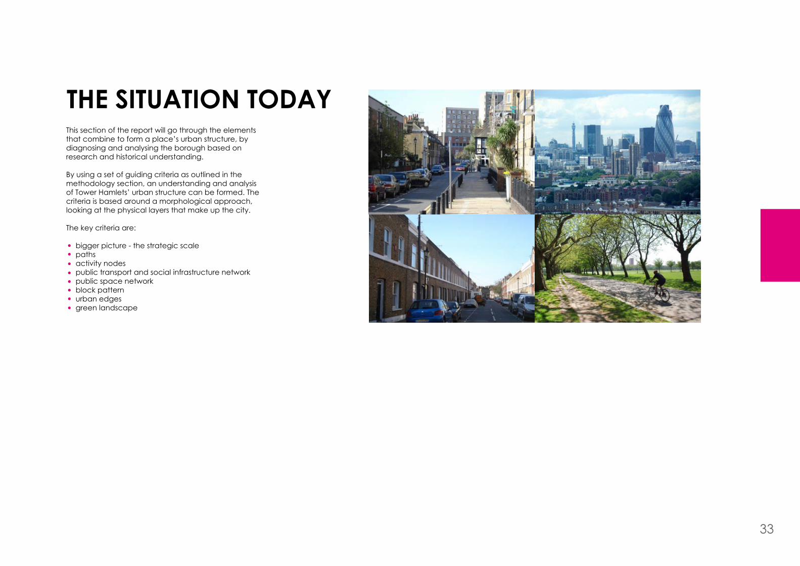
the sItUatION tODaYThis section of the report will go through the elements that combine to form a place’s urban structure, by diagnosing and analysing the borough based on research and historical understanding.
by using a set of guiding criteria as outlined in the methodology section, an understanding and analysis of Tower hamlets’ urban structure can be formed. The criteria is based around a morphological approach, looking at the physical layers that make up the city.
The key criteria are:
bigger picture - the strategic scale paths activity nodespublic transport and social infrastructure networkpublic space networkblock patternurban edgesgreen landscape
33
Crown Copyright. All Rights reserved. London borough of Tower hamlets 100019288 2009
Crown Copyright. All Rights reserved. London borough of Tower hamlets 100019288 2009
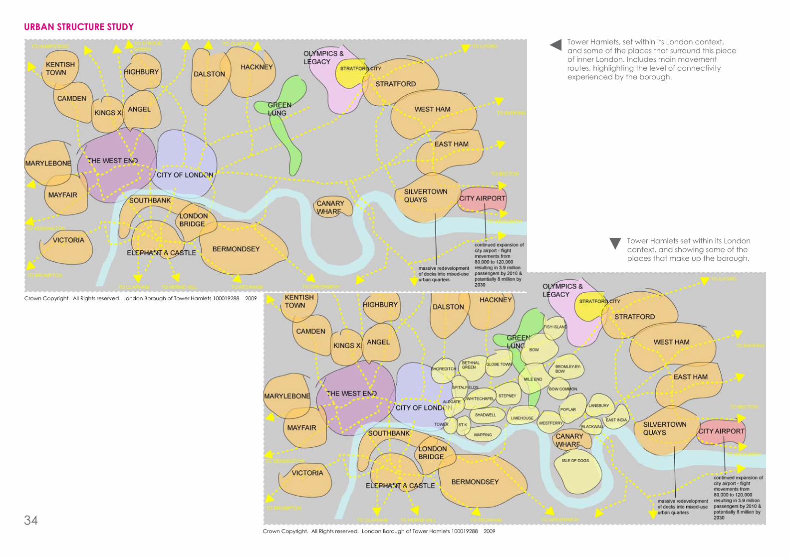
UrbaN strUctUre stUDYTower hamlets, set within its London context, and some of the places that surround this piece of inner London. Includes main movement routes, highlighting the level of connectivity experienced by the borough.
Tower hamlets set within its London context, and showing some of the places that make up the borough.
34
Crown Copyright. All Rights reserved. London borough of Tower hamlets 100019288 2009
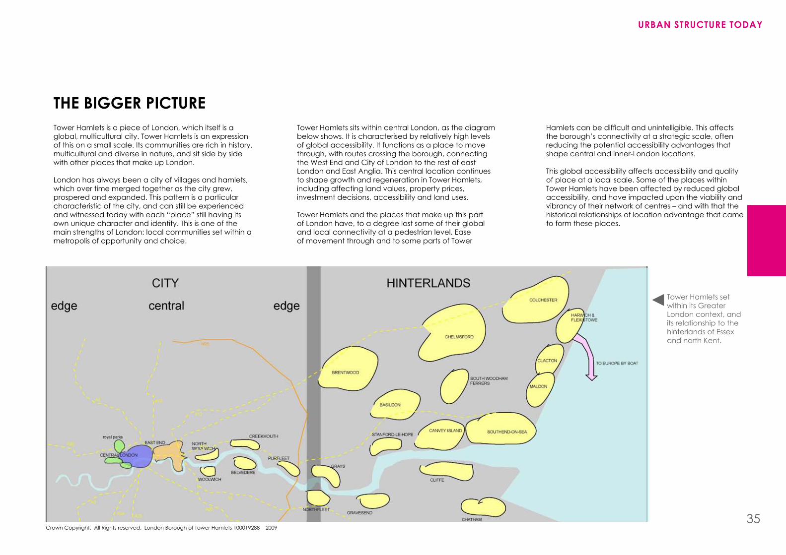
the bIGGer PIctUreTower hamlets is a piece of London, which itself is a global, multicultural city. Tower hamlets is an expression of this on a small scale. Its communities are rich in history, multicultural and diverse in nature, and sit side by side with other places that make up London.
London has always been a city of villages and hamlets, which over time merged together as the city grew, prospered and expanded. This pattern is a particular characteristic of the city, and can still be experienced and witnessed today with each “place” still having its own unique character and identity. This is one of the main strengths of London: local communities set within a metropolis of opportunity and choice.
Tower hamlets sits within central London, as the diagram below shows. It is characterised by relatively high levels of global accessibility. It functions as a place to move through, with routes crossing the borough, connecting the West End and City of London to the rest of east London and East Anglia. This central location continues to shape growth and regeneration in Tower hamlets, including affecting land values, property prices, investment decisions, accessibility and land uses.
Tower hamlets and the places that make up this part of London have, to a degree lost some of their global and local connectivity at a pedestrian level. Ease of movement through and to some parts of Tower
Hamletscanbedifficultandunintelligible.Thisaffectsthe borough’s connectivity at a strategic scale, often reducing the potential accessibility advantages that shape central and inner-London locations.
This global accessibility affects accessibility and quality of place at a local scale. Some of the places within Tower hamlets have been affected by reduced global accessibility, and have impacted upon the viability and vibrancy of their network of centres – and with that the historical relationships of location advantage that came to form these places.
Tower hamlets set within its Greater London context, and its relationship to the hinterlands of Essex and north Kent.
UrbaN strUctUre tODaY
35
UrbaN strUctUre stUDY
36
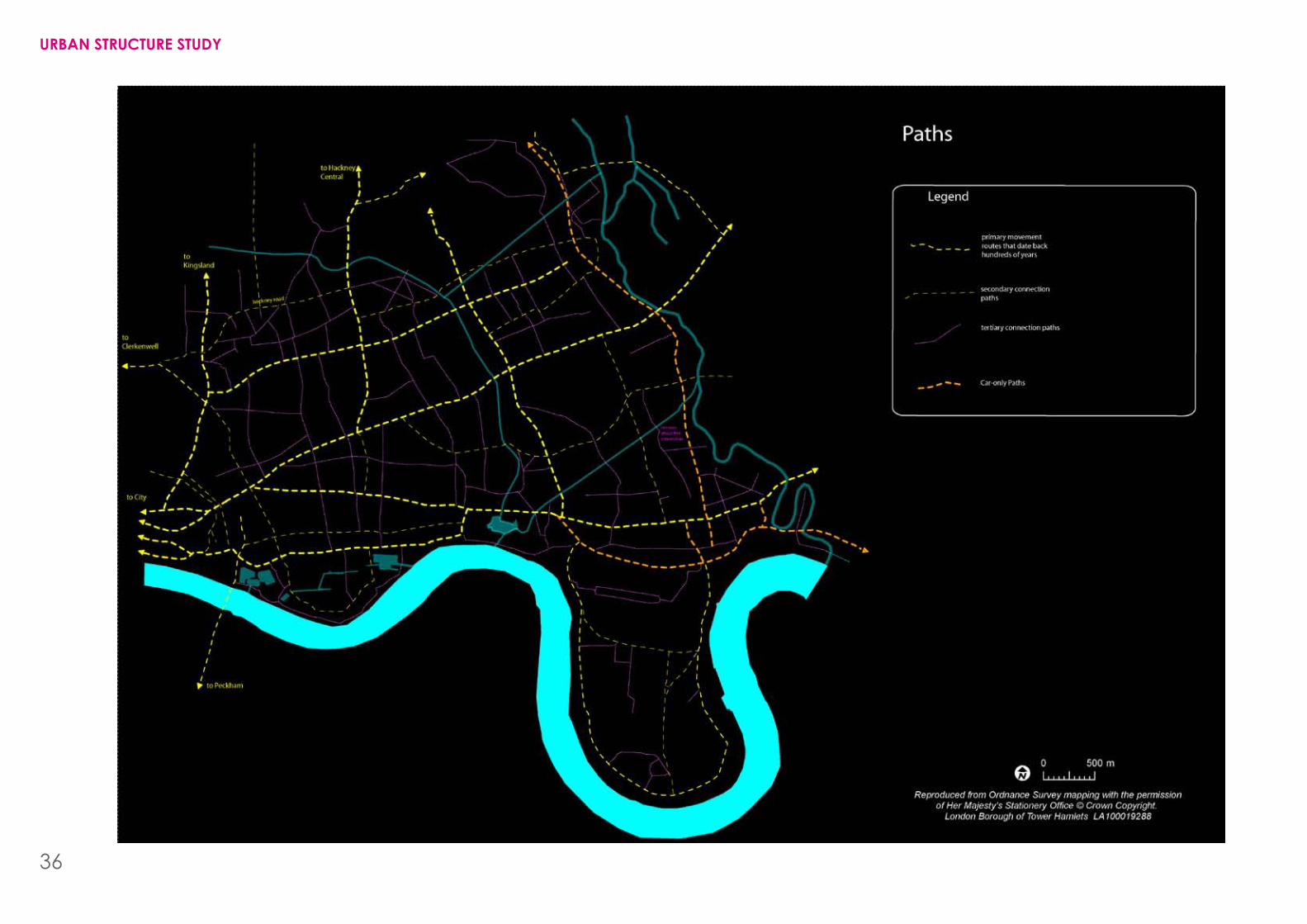
PathsAs can be seen from the paths diagram, there is a hierarchy that operates across the borough based upon pedestrian accessibility and the connectivity of that route: from the most connected streets, such as bow Road, down to less connected streets. Generally the longer the path, the more connected that path is. It will take you to a greater number of places, via a greater number of other places. People naturally read when they are on a street that is well connected. It has more people, more activity, and the buildings are usually of a larger scale.
Tower hamlets’ urban structure is heavily dependent upon the three key paths that run west to east through the borough. These paths have existed for hundreds of years (see historical maps):
•BethnalGreenRoad,whichturnsintoRomanRoad•WhitechapelHighStreet,whichturnsintoBowRoad•CommercialRoad,whichturnsintoEastIndiaDockRoad
Unconnected paths
Some of the paths in Tower hamlets do not connect, which limits the connectivity of those routes as people cannot use them to get access to other paths. This impacts upon the overall accessibility of a place. People want a whole variety of movement routes, different ways to get from A to b. The movement network should accommodate this and promote connected, permeable and accessible environments.
There are many instances where paths create dead ends. This impacts upon the intelligibility of a place. When a pedestrian walks down a path that is a dead end,itmeanstheyhavetoback-trackinordertofindanew route to where they want to go.
car-only paths
There are a number of paths in the borough that do not allow or encourage pedestrian use. Aspen Way and the A12 are examples of this: roads purposefully excludingthepedestrianinordertofulfilthemovementneeds of vehicles. They are not as multifunctional paths. Due to their inhospitability to the pedestrian, these paths actually end up forming barriers to pedestrian movement, with people having to go over or under them in order to get where they want to go. This can be seen in places such as blackwall, Poplar Riverside, bromley-by-bow and Fish Island.
Quality of paths
The quality of paths can at times be poor for a number of reasons, often because the pedestrian comes second to the car. The right balance in some cases is not achieved. The pedestrian environment needs greater priority. It is harder to create a quality environment for the pedestrian than it is for the car, therefore greater care, design and importance should be placed upon the pedestrian experience, with the car being accommodated in this balance. Paths such as the highway, Commercial Road, burdett Road, and Westferry Road are all unfriendly to the pedestrian, thereby discouraging people from walking or cycling, which impacts upon health and well-being.
Primary paths
The paths that run north-south through the borough are fewer and less connected than those paths that run east-west. This makes movement in a north-southdirectionmoredifficultandcomplex,aswellasimpacting upon diagonal movement (south-east to north-west, for example).
Paths such as Globe Road, burdett Road, and Cambridge heath Road do not function as primary paths. The built form alongside these paths often fails to frame the space, affecting the clarity and intelligibility of their connection. This supports and partly explains the issue of how poorly connected the borough is to the Thames. It is physically close, yet often very inaccessible. These north-south paths do not make the logical conclusion of connecting to the river and opening up access.
secondary paths
Primary paths such as bethnal Green Road, Whitechapel high Street and Commercial Road are relatively coherent, connected and intelligible. This is less the case with many secondary paths in the borough. Many create dead ends, do not read as secondary paths, poorly connect to primary paths and are too few in areas like the east of the borough.
This impacts upon neighbourhood accessibility and the quality of pedestrian movement, making it hard for the pedestrian to go from a local path via a secondary path to a primary path. It discourages through movement and limits the walkability of the neighbourhood.
UrbaN strUctUre tODaY
37
UrbaN strUctUre stUDY
38
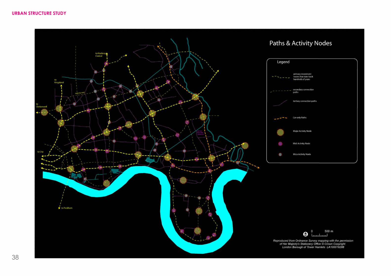
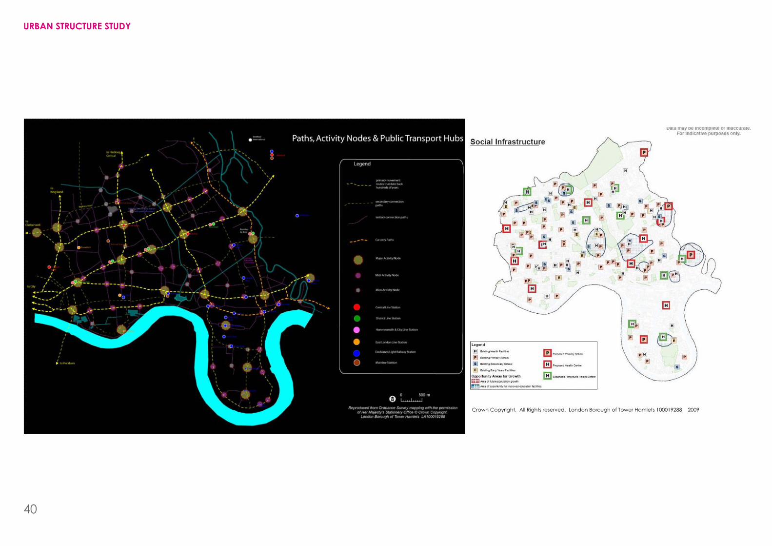
actIvItY NODesNodal points, often created by the convergence and crossing of paths serve to act as foci-points in the urban landscape. They are places where people come together. As they are interlinked with paths, they also share a similar hierarchy. When two or more primary paths cross or converge, a major node is created. Similarly, when two more local paths cross, a smaller, less intense node is created.
Many parts of the borough have these nodes, which have a strong relationship to the paths that create them. Tower hamlets has many linear centres, which run along key movement routes to form high streets, a typically English urban condition. Shops and businesses locate around and along these nodes due to their high accessibility and high levels of footfall.
historically markets locate along these key routes (Roman Road, bethnal Green, Whitechapel) supporting and establishing a unique relationship with the shops that operate, helping to create a greater degree of vibrancy.
Unconnected paths create few meeting places
As discussed under the paths analysis, much of our path network fails to join up, creating dead ends and cul-de-sacs. This has implications for the creation of nodes, which function as places where people can meet, as they are predominately only located at the convergence or crossing of paths. This limits accessibility, and thus opportunity for social and economic transaction.
lack of nodes
There is a lack of smaller and medium-sized nodes across the borough, which impacts upon the creation of successful and connected neighbourhood centres. This has in some cases resulted in a fragmented dispersal of commercial and civic uses which collectively fail to form a critical mass of shops and services that can support one another.
Unfocused nodes
Many existing nodes fail to take advantage of their primary role as framers of activity. Often buildings do not enclose public space adequately; cars dominate the publicspaceandthereisverylittleground-flooractivity.This can contribute to an empty and inhospitable atmosphere. These nodes do not function as places where you would want to meet and linger. The junction of Commercial Road, East India Dock Road, burdett Road and Westferry Road are good examples of such a condition.
What can be seen from the map opposite is that many areas in the east of the borough have failed to form and capitalise on their nodes; failed to form highly accessible, viable centres which provide a focal point. Commercial and civic uses have instead been dispersed or introverted from the key paths and activity nodes, and disconnected from pedestrian footfall, limiting economic and social transaction. bromley-by-bow is such an example, where commercial uses are separated from the path network, making it hard for pedestrians to access the supermarket.
Quality of nodes
In the instances where the nodes do function as places of activity, with a mix of uses – such as in bethnal Green and Cambridge heath – the quality of the space between buildings discourages people to linger. Cars often dominate the space; there is a lack of outdoor seating and places to eat and drink, combined with poor quality public space. To function as meeting places, they need to be hospitable, comfortable, enjoyable and safe for pedestrians and cyclists.
UrbaN strUctUre tODaY
39
Crown Copyright. All Rights reserved. London borough of Tower hamlets 100019288 2009
UrbaN strUctUre stUDY
40
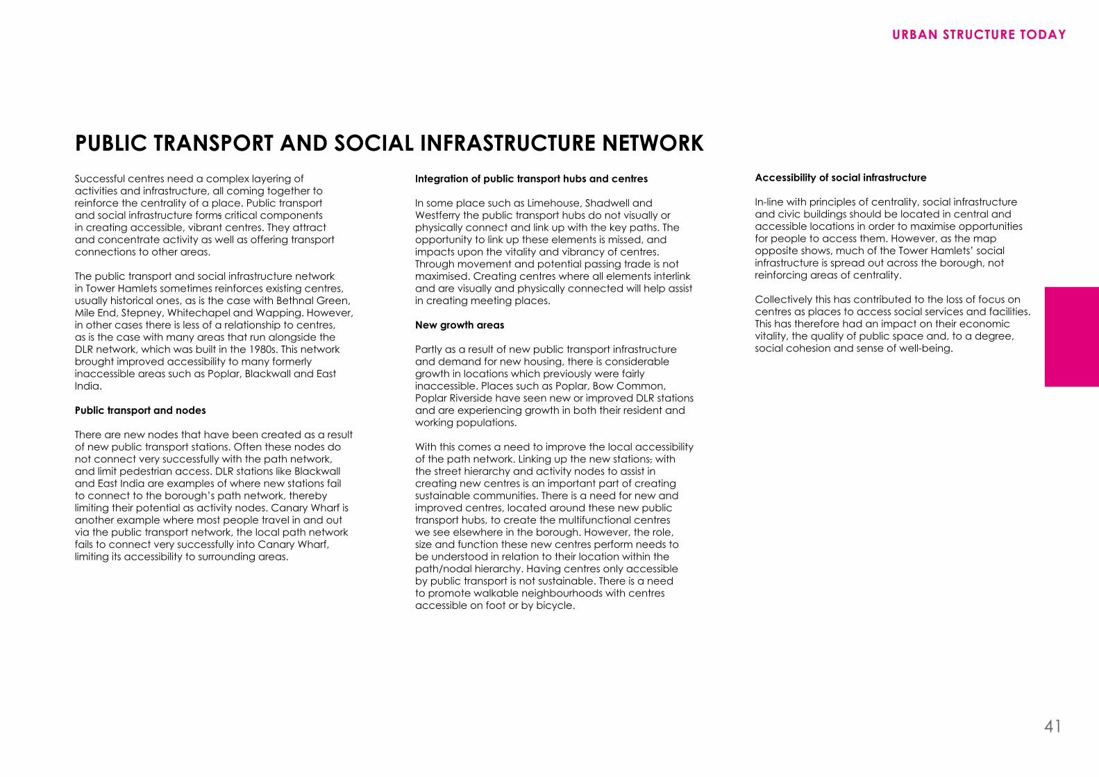
PUblIc traNsPOrt aND sOcIal INFrastrUctUre NetWOrkSuccessful centres need a complex layering of activities and infrastructure, all coming together to reinforce the centrality of a place. Public transport and social infrastructure forms critical components in creating accessible, vibrant centres. They attract and concentrate activity as well as offering transport connections to other areas.
The public transport and social infrastructure network in Tower hamlets sometimes reinforces existing centres, usually historical ones, as is the case with bethnal Green, Mile End, Stepney, Whitechapel and Wapping. however, in other cases there is less of a relationship to centres, as is the case with many areas that run alongside the DLR network, which was built in the 1980s. This network brought improved accessibility to many formerly inaccessible areas such as Poplar, blackwall and East India.
Public transport and nodes
There are new nodes that have been created as a result of new public transport stations. Often these nodes do not connect very successfully with the path network, and limit pedestrian access. DLR stations like blackwall and East India are examples of where new stations fail to connect to the borough’s path network, thereby limiting their potential as activity nodes. Canary Wharf is another example where most people travel in and out via the public transport network, the local path network fails to connect very successfully into Canary Wharf, limiting its accessibility to surrounding areas.
Integration of public transport hubs and centres
In some place such as Limehouse, Shadwell and Westferry the public transport hubs do not visually or physically connect and link up with the key paths. The opportunity to link up these elements is missed, and impacts upon the vitality and vibrancy of centres. Through movement and potential passing trade is not maximised. Creating centres where all elements interlink and are visually and physically connected will help assist in creating meeting places.
New growth areas
Partly as a result of new public transport infrastructure and demand for new housing, there is considerable growth in locations which previously were fairly inaccessible. Places such as Poplar, bow Common, Poplar Riverside have seen new or improved DLR stations and are experiencing growth in both their resident and working populations.
With this comes a need to improve the local accessibility of the path network. Linking up the new stations, with the street hierarchy and activity nodes to assist in creating new centres is an important part of creating sustainable communities. There is a need for new and improved centres, located around these new public transport hubs, to create the multifunctional centres we see elsewhere in the borough. however, the role, size and function these new centres perform needs to be understood in relation to their location within the path/nodal hierarchy. having centres only accessible by public transport is not sustainable. There is a need to promote walkable neighbourhoods with centres accessible on foot or by bicycle.
accessibility of social infrastructure
In-line with principles of centrality, social infrastructure and civic buildings should be located in central and accessible locations in order to maximise opportunities for people to access them. however, as the map opposite shows, much of the Tower hamlets’ social infrastructure is spread out across the borough, not reinforcing areas of centrality.
Collectively this has contributed to the loss of focus on centres as places to access social services and facilities. This has therefore had an impact on their economic vitality, the quality of public space and, to a degree, social cohesion and sense of well-being.
UrbaN strUctUre tODaY
41
UrbaN strUctUre stUDY
42
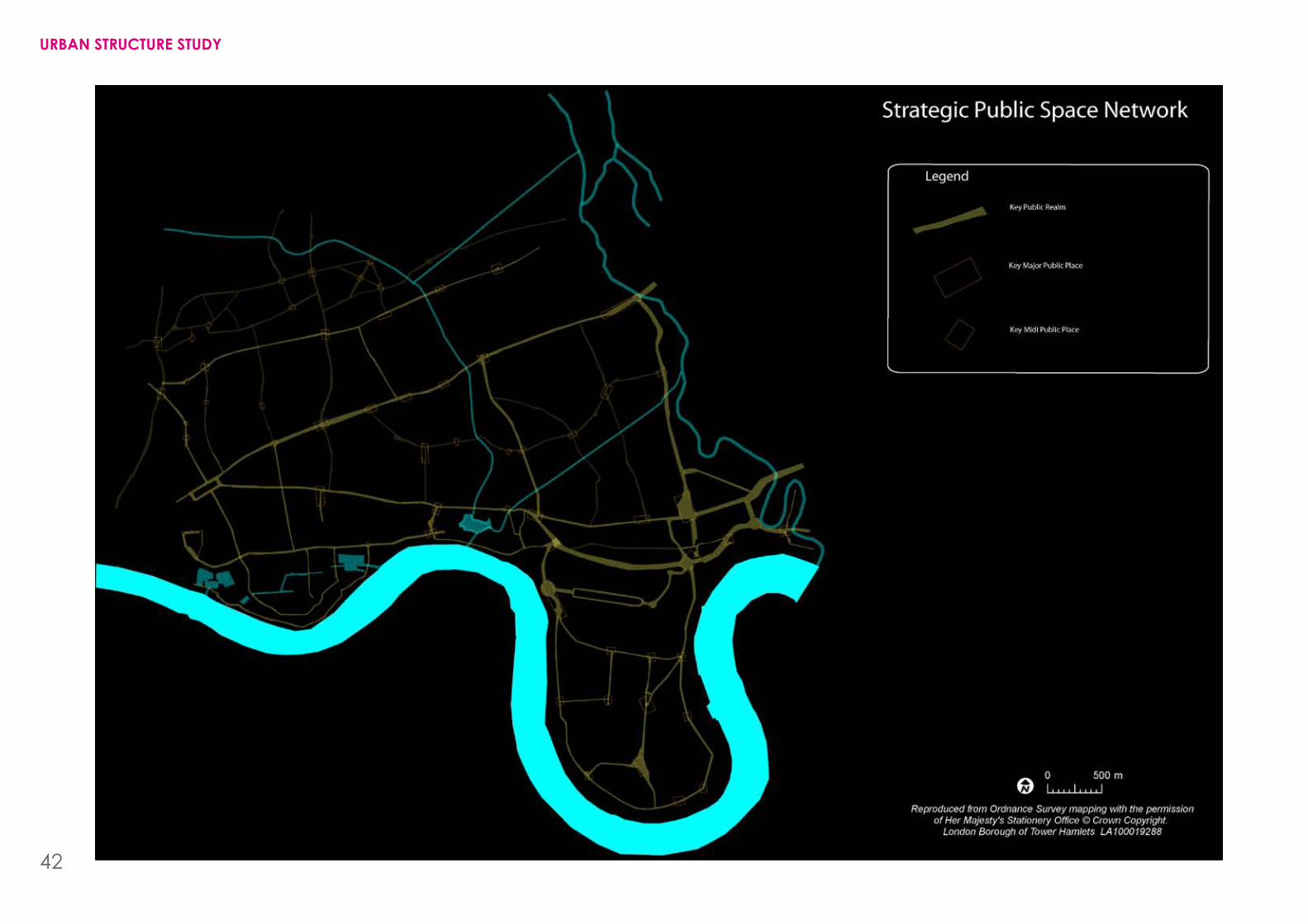
PUblIc sPace NetWOrkhow are public spaces in Tower hamlets used? This is an important question if we are to begin to promote quality of life for our residents. The public realm in which local people spend most of their time, the streets, squares, alleys and green spaces can either encourage or discourage interaction.
To create meaningful and vibrant public spaces there needs to be an understanding of the subtle and definablequalitiesthatencouragepeopletomeetanduse public spaces.
enclosure and continuity
The way in which buildings relate to public space – the relationship between internal and external space – is an important consideration in the perceived quality of the urban environment. Many buildings in Tower hamlets fail to relate to the public realm and its hierarchy. What is meant by that is twofold:
• Firstly, the form, scale, height and massing of buildings fail to respond to the hierarchy of that street – i.e. taller buildings on main streets and smaller ones on the minor streets.
• Secondly, buildings fail to create continuous frontage to the public realm in a way that responds to the function and importance of that street – i.e. large setbacks, breaks in elevations, and long blank façades fail to animate public space.
In addition, the poor enclosure of space also assists in creating a poor microclimate, where wind vortexes can dominate and make the space unpleasant and uncomfortable for the pedestrian.
Inactive edges to spaces
Spaces become animated from the edges. Evidence shows that people naturally populate the edge of a space. The centre of public space is usually the least used and needs other techniques to animate it, such as fountains,trees,benchesandcafés.
Some buildings that frame public spaces in Tower Hamletsdonotalwaysofferactive,ground-flooruses.There are too many blank, dead edges which fail to encourage activity around the fringe of the space and therefore never gain any activity closer to the centre.
Quality space
Much of the public space in Tower hamlets is not designed to the quality that encourages optional activities. Many spaces are therefore poorly used, comprisingunattractivetrafficislands,gyratory’sandwindswept spaces in which people would rather not stay and linger.
Unconnected spaces
The interconnectivity of the public space network is often poor and unintelligible. The main public spaces do not always relate to the main paths that carry pedestrianflow.Thepathsthatconnectneedtobeof the same high quality as the squares, otherwise the opportunity for greater inclusiveness and vitality is lost.
Public squares
Much of the public space network in Tower hamlets is linear in typology. There are fewer spaces that have three or four sides, such as squares, triangles, or other shapes. Often these shapes allow more lingering, calm areas and places to meet and stay. The ones we do have are dominated by vehicles. Squares set off paths can offer rest spaces for citizens, relief from the hustle and bustle of the street. If framed by buildings on many sides, these spaces can offer a great sense of enclosure and microclimate.
UrbaN strUctUre tODaY
43
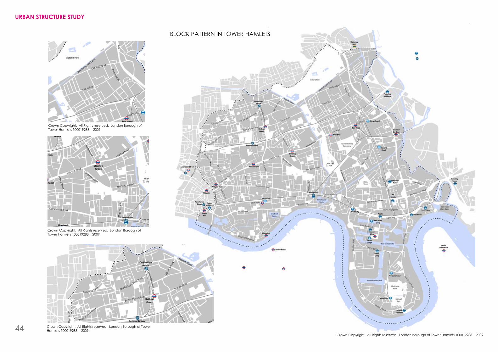
Crown Copyright. All Rights reserved. London borough of Tower hamlets 100019288 2009
Crown Copyright. All Rights reserved. London borough of Tower hamlets 100019288 2009
Crown Copyright. All Rights reserved. London borough of Tower hamlets 100019288 2009
Crown Copyright. All Rights reserved. London borough of Tower hamlets 100019288 2009
Crown Copyright. All Rights reserved. London borough of Tower hamlets 100019288 2009
UrbaN strUctUre stUDY
bLOCK PATTERN IN TOWER hAMLETS
44
UrbaN blOck PatterNThe block pattern is created as a result of the path network. Paths are set down and shaped by movement patterns, from which parcels of land are left which we can call blocks. These blocks are then composed of plots, the individual pieces of privately owned land which buildings are built on.
The size and shape of blocks varies considerably from one area to another in Tower hamlets, which has a direct impact upon the permeability of the borough.
blocks which create barriers
There are instances where large blocks limit the walkability of a place. Some are over 250m in length which requires a fairly large detour for the pedestrian to get to where they want to go.
Underdeveloped blocks
Many blocks have uses and buildings on them that do not optimise the use of the land. This is wasteful and creates under-used and inactive parts of neighbour-hoods. This impacts upon movement patterns with pe-destrians avoiding these under-used and isolated areas.
Interface between public and private
Many buildings have their public fronts facing inwards into a block and their private back facing the public realm. This means blocks are introverted, providing no active edge or sense of activity for the public realm, and contributing little to the street scene.
size in relation to centres
In many centres and activity nodes the blocks that form the structure are often very large, which limits the variety of activities that can occur. Smaller blocks are better located in centres, as with smaller block sizes you can achieve more built edge, and more active frontages, hence more uses and activities can occur. Mile End is an example of where the block structure is too large in and around the centre.
segregation of users
With many blocks, pedestrians can move through, along and around buildings; cars are sent another way, and cyclists another direction. Separating out users in distinct paths is wasteful and duplicates the land needed for movement. It can lead to a situation where a path is not well used and does not have enough activity to make it feel safe, overlooked and useable. This can also reduce the permeability and walkability of a place.
Through careful design integration these users can successfully use the same path in most cases.
Fragmented block structure and estates
Many large blocks operate as segregated units in the urban fabric, with dead ends and routes that are unintelligible to the unacquainted pedestrian. This can isolate users into those who can navigate these blocks, and those who cannot. This can assist in forming no-go areas and limit the permeability of a place. This can culminate in a situation where residents of an estate feel so detached from the wider urban structure that they form isolated territories.
Movement in the east of tower hamlets
The block pattern in Tower hamlets differs across the borough. Generally the eastern edge of Tower hamlets is comprised of larger blocks. This is largely due to the historic industrial nature of this area, and, to a degree, the post-war housing developments after bombing and slum clearance.
Along the eastern edge of Tower hamlets there are also a series of physical barriers that reduce permeability. These comprise major roads (including the A12 and Aspen Way) the River Lea, the canals and the railway lines. Smaller block sizes are generally found in the centre of Tower hamlets, the Isle of Dogs and along the western edge, due the historic, residential-led use in this area.
UrbaN strUctUre tODaY
45
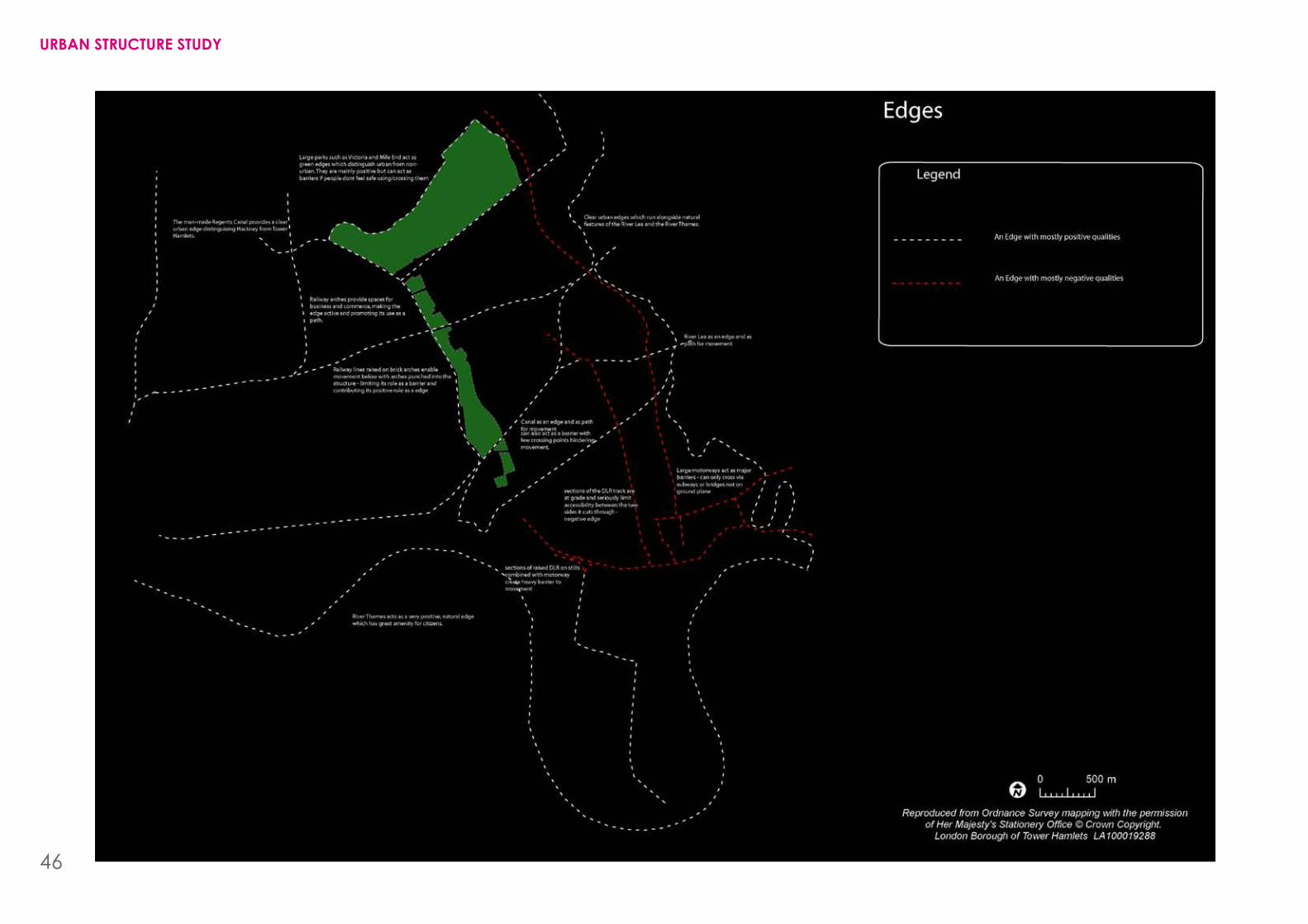
UrbaN strUctUre stUDY
46
UrbaN eDGesPositive edges
Edgescanassistingivingdistinctionanddefinitiontoplaces. You know you are beginning to leave bethnal Green and enter Whitechapel as you pass under the railway arches. This edge is positive, it frames your place reference, but also allows you to move through it or along it. It increases your urban experience without hinderding your movement.
Natural features in Tower hamlets often act as positive edges. They offer the citizen a connection to the natural landscape, its power as a shaper of the city. This landscape gives us a sense of our place in the environment and puts us into context.
The River Thames is the most obvious natural edge, its edge very distinct, giving you a sense of being in London, on the north bank, offering views across and along the river, and giving a strong sense of connection to the natural environment.
The role of the Thames is under-utilised in Tower hamlets. Its potential as an edge and as a path could be significantlypromoted.Atpresentitishardtoaccess,both physically and visually. The path network does not always make strong, clear links to the Thames edge. The South bank is a prime example of how the river’s assets can be maximised.
The River Lea offers a similar function to the Thames, but is even more under-utilised. Its industrial use over the years has discouraged its potential as a positive edge and natural movement path. Access to the river is very poor and the quality of the environment discourages people from using it. Also, connections across the river are very infrequent.
The man-made canal network offers positive edges to places and the towpath offers a desirable, attractive movement path for pedestrians and cyclists. Connections across the canals are in most cases frequent, so they do not pose a massive barrier. Their role is also changing, with older industrial uses that clustered along them moving elsewhere, and more residential and mixed development being brought forward.
The man-made environment also offers edges, many of which are positive. The railway arches create edges, often giving a positive edge to a place, a sense of character and vitality, and displaying the strategic role of the city and its transport links. In some places the arches allow at-grade movement and activity making this piece of urban infrastructure sensitive to its surroundings, and useable for local people.
edges as barriers
Edges, as discussed, play a wide role in the cityscape. Strategic infrastructure across the borough forms, in some cases, negative barriers – both physical and visual.
bishopsgate Goods Yard is an example where the railway infrastructure has created a large barrier to movement,limitingnorth-southroutesfromSpitalfieldsto bethnal Green, contributing to a feeling of isolation in the area.
TheDLRtracksatgradeoftencauseasignificantbarrier,stopping ease of movement from one place to another. This is also true of the A12 and Aspen Way, where car onlymotorways,heavywithtraffic,requirepeopletogo under or over them to cross, disrupting their natural desire lines and limiting movement patterns. This has had the effect of severing the centres and hearts of places – as seen at bromley-by-bow.
UrbaN strUctUre tODaY
47
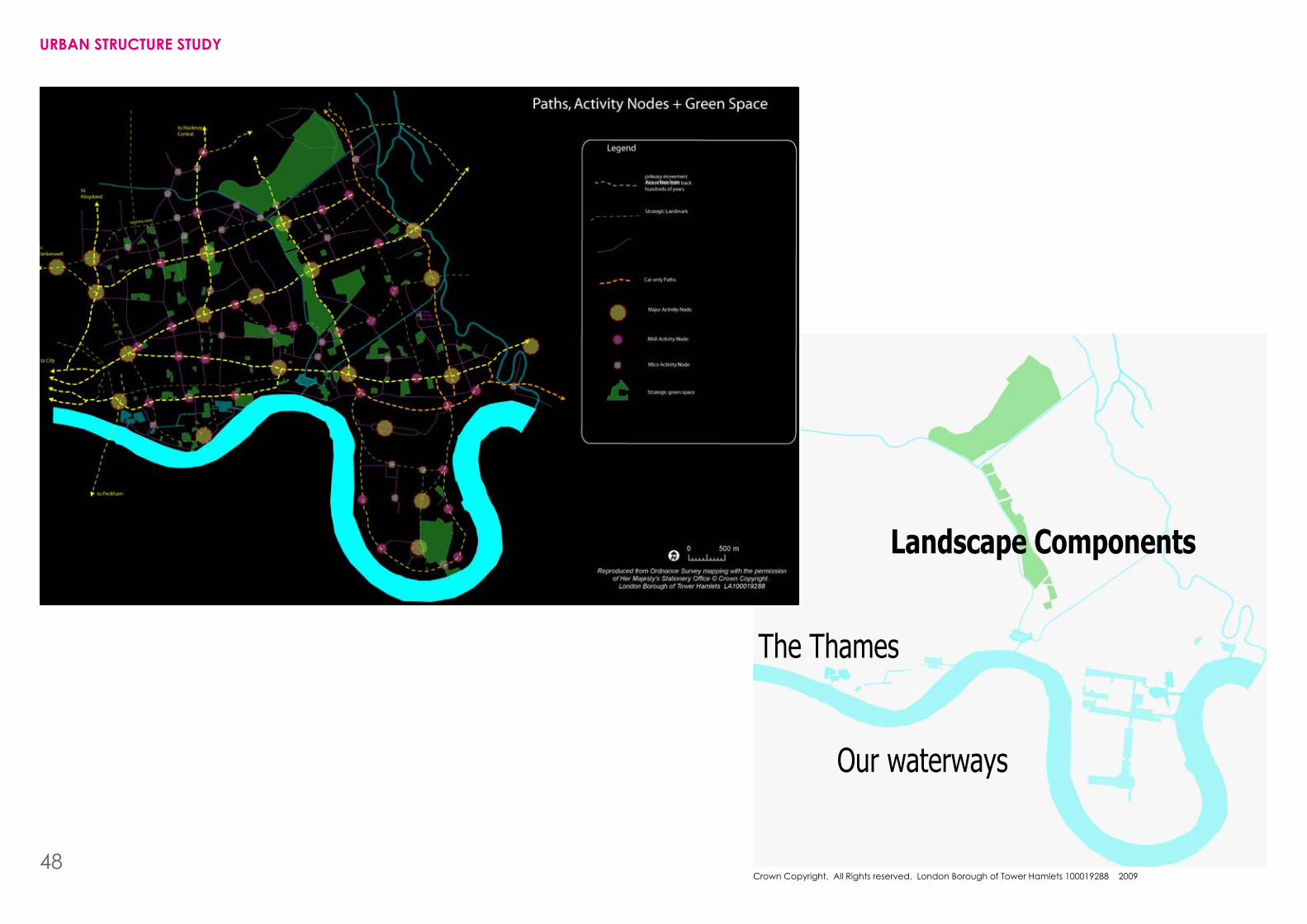
Crown Copyright. All Rights reserved. London borough of Tower hamlets 100019288 2009
Landscape Components
Our waterways
The Thames
UrbaN strUctUre stUDY
48
GreeN laNDscaPeA network of green spaces is evident across the borough. These parks provide much valued play areas, access to nature, space for events, space to relax and unwind, and help with the general well-being of residents.
In a relatively dense, inner-city part of London green spaces are extremely important. And because of space limitation, the green space network is heavily protected and valued. Issues such as quality, accessibility and the range and types of green space on offer are key considerations. Green spaces in themselves are not necessarily good: they have to be good quality; well maintained;reflecttheusers;beintegratedintolocalneighbourhoods; and be safe and pleasant to use. If these qualities are not achieved then green spaces can be negative spaces, creating no-go areas and contributing to feelings of danger.
Green spaces acting as barriers
While green spaces can be magnets of activity and people, when they are unloved and little-used, they can act as barriers. This is often the case when dark falls and people are afraid to walk through, or close to, green spaces, for fear of being mugged. It is only if green spaces are well used, attractive and overlooked with enough eyes that people tend to walk through them; otherwise they act as serious barriers to movement.
edges of Green space
Activity, and so vitality, is emitted from the edges of buildings and creeps into the central space if there is sufficientactivitytocauseitto.Thesameappliestogreen spaces: often the edges of green spaces are dead, poorly overlooked, with a feeling of emptiness. This prevents the heart of the park from being used, as people don’t feel safe venturing into it.
role and function of green space
Much housing-estate amenity land does not offer the qualitiesandbenefitswantedbylocalsfromtheirgreenspaces. Much of this land is semi-public or semi-private, which often means that no one really thinks they are en-titled to use it. The residents feel its too open and public for everyday use, and the public regard it as land for people who live on the housing estate. This real confu-sion between public and private underpins why so much amenity land is unloved, decaying and little-used.
connecting with nature
Green spaces not only offer places for people to relax and be close to nature, but can also be important assets for local wildlife. This is not automatically the case, and green spaces have too often been designed without regard to how they affect biodiversity.
UrbaN strUctUre tODaY
49
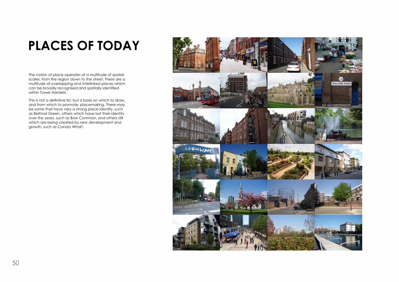
Places OF tODaY
The notion of place operates at a multitude of spatial scales, from the region down to the street. There are a multitude of overlapping and interlinked places which canbebroadlyrecognisedandspatiallyidentifiedwithin Tower hamlets.
Thisisnotadefinitivelist,butabasisonwhichtodraw,and from which to promote, placemaking. There may be some that have very a strong place identity, such as bethnal Green, others which have lost their identity over the years, such as bow Common, and others still which are being created by new development and growth, such as Canary Wharf.
50
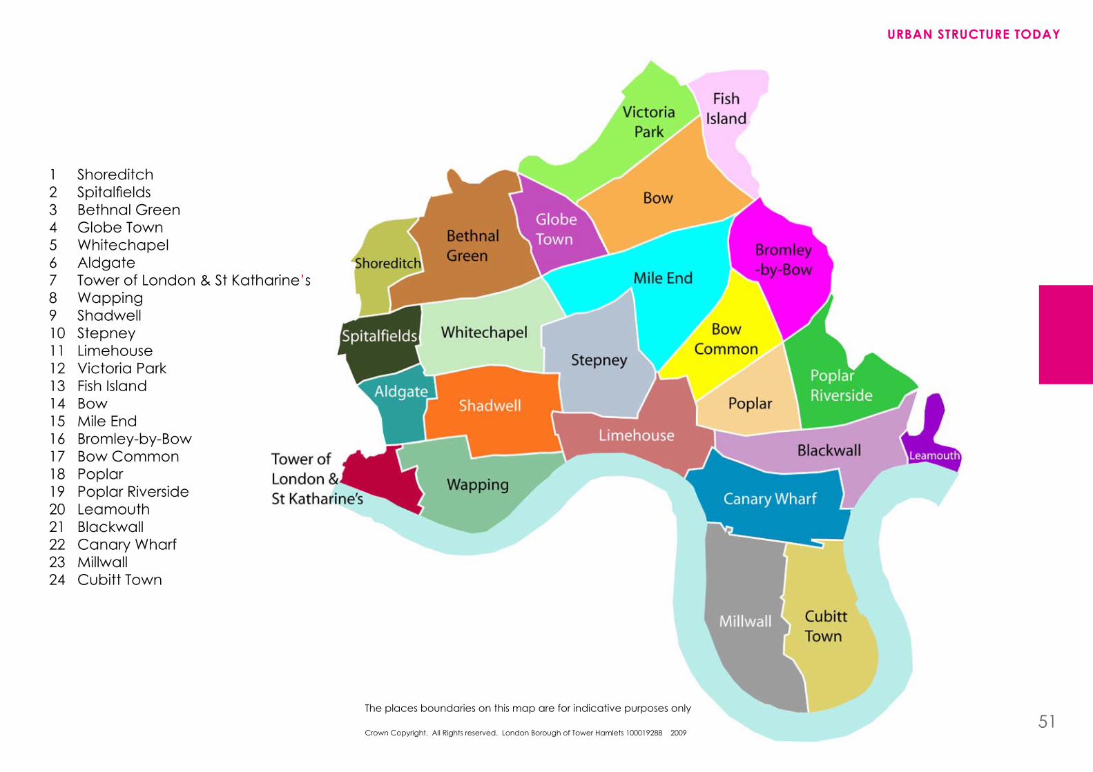
ShoreditchSpitalfieldsbethnal GreenGlobe TownWhitechapelAldgateTower of London & St Katharine’sWappingShadwellStepneyLimehouseVictoria ParkFish IslandbowMile Endbromley-by-bowbow Common PoplarPoplar RiversideLeamouthblackwallCanary WharfMillwall Cubitt Town
123456789101112131415161718192021222324
UrbaN strUctUre tODaY
The places boundaries on this map are for indicative purposes only51
Crown Copyright. All Rights reserved. London borough of Tower hamlets 100019288 2009