urban restructuring (mohalla baazi forum)
TRANSCRIPT

URBAN RESTRUCTURINGA rational study on Shah Jamal Colony

VISION
Since past few decades ,the growth of Lahore has increased rapidly in terms of its area and population that has resulted Social disintegration,land use zones based on extreme density variations and serious traffic congestion on thorough fares .There is a need for alternate Strategy to restructure the city into human oriented walkable towns* with transit connectivity and each town consists of its basic needs , utilities and Social infrastructure. Cities must look not only to expand along their peripheries but also reclaim their central areas by marginal changes which have been neglected by the policy and decision makers. Shah Jamal colony is one such area in which Katchi abadi has been facing urban degradation and needs a comprehensive plan to become the part of integrated neighbourhood.
*www.thelahoreproject.com

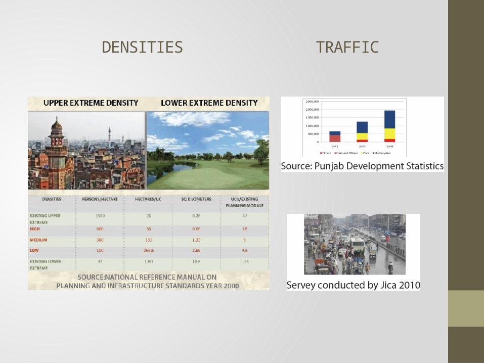
DENSITIES TRAFFIC

LOCATION
Area is located in the center of thecity.Canal on its East side, Ferozpur on its west, Shadman on the north, Fazlia colony towards its south.

AREA SELECTION
Settlements with variation in densityfrom upper extreme to lower extreme Adjoining area between major thoroughfaresSignificance of shah jamal shrineBeside rapid transit station

EXISTING HARD DATA
Dimensions : Total area : Total population of the residents :Principal roads :
1.10 Km by 0.28 KM2423968.45 sq ft, 55 Acres7,716Ferozpur, Canal, Shah Jamal
Residential building units: Commercial building units:Mix use building units:Educational institutions:
Religious buildings:
Vehicles owned by the residents:
6692782Bloomfield school , Apa nisar model girls high school.Shah Jamal Shrine ,Masjid Kreemia, Saien M Shareef shrine, Syed Pir zada shrine, 2 madrassas291 cars,993 bikes,94 bicycles

AIM
The aim of the project is to provide a community development program on neighbour-hood level through analyzing the existing settlements and its systems, providing inter-vention through participatory design.
OBJECTIVES
To activate Shah Jamal as a major neighborhood of the cityRestructuring the existing settlements to develop as a more efficient working community with upgraded living environment Basic amenities provision for healthy growth of children.The idea of empowerment through a community-led approach.

HISTORICAL MAPPINGS
Saint Shah jamal died in 1628 A.D.His shrine existed here since that time, his devotees started living beside it in the form ofkatchi abadi settlements.

HISTORICAL MAPPINGS
After partition when roads and streets were planed areas wereallotted to the eastern side of shrine which are low in density and plot areas vary from 2 kanal to 6 kanal.Then after 1986 Katchi Abadi settlements were given the rights of ownership.

AREA GROWTH

SPATIAL SYSTEMS
FIGURE GROUND MAP
SPATIAL SYSTEMS
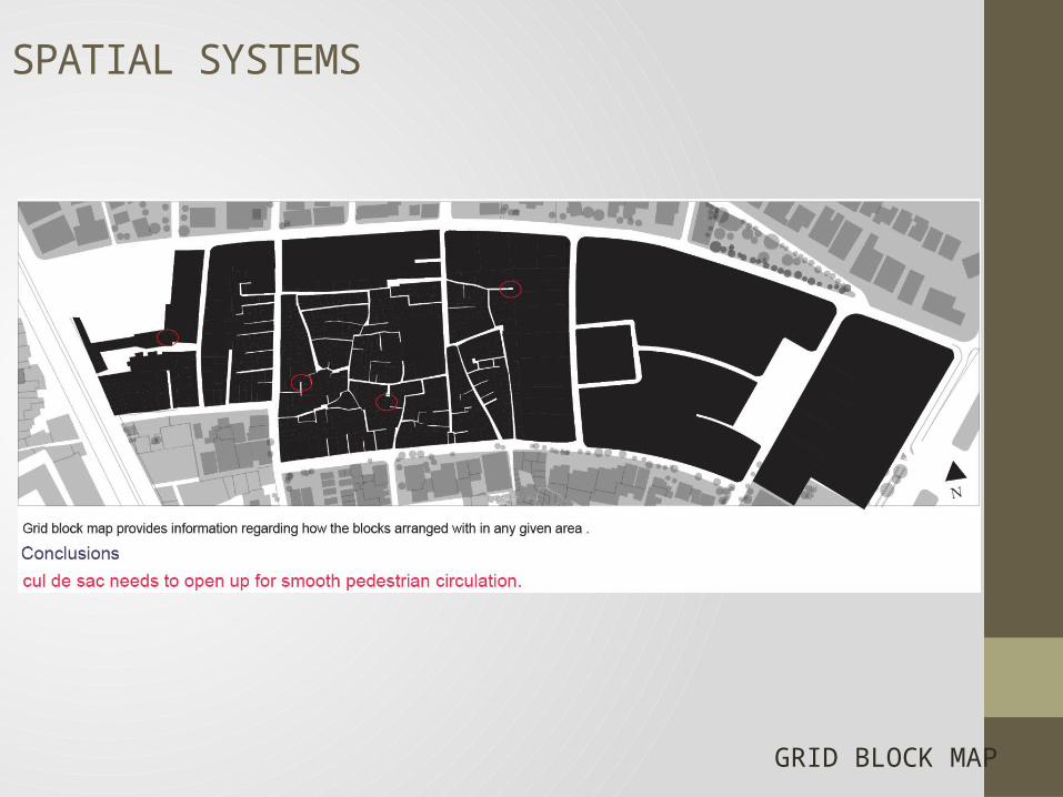
GRID BLOCK MAP

SPATIAL SYSTEMS
ARTERIES

SPATIAL SYSTEMS
LINKS
Conclusionschaotic arrangement of housing and lack of open space in the high dense area.cul de sac needs to open up for smooth pedestrian circulation.

LANDUSE
BASEMENT

LANDUSE
GROUND FLOOR

LANDUSE
FIRST FLOOR

SECOND FLOOR
LANDUSE

LANDUSE
THIRD FLOOR

LANDUSE PERCENTAGE
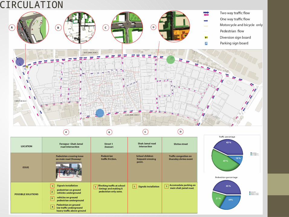
CIRCULATION

CIRCULATION (PROPOSED)

MAIN STREET

STREETS


primary school smaller in sizeboys travel to far off distance
Primary and secondary school
HOSPITAL AND SCHOOLS

DEMOGRAPHICS
The analysis shows the literacy rate is less in the area because of no government school available .
Employment rate is less as well which can be upgraded by improving the cottage industries operating in the area.

DEMOGRAPHICS

DEMOGRAPHICS
The users of public metro bus are less , which can be enhanced by improving the walkable quality on road.Area is lacking water availability because of over age limit of pump and underutilized water supply pipe.

UTILITIES

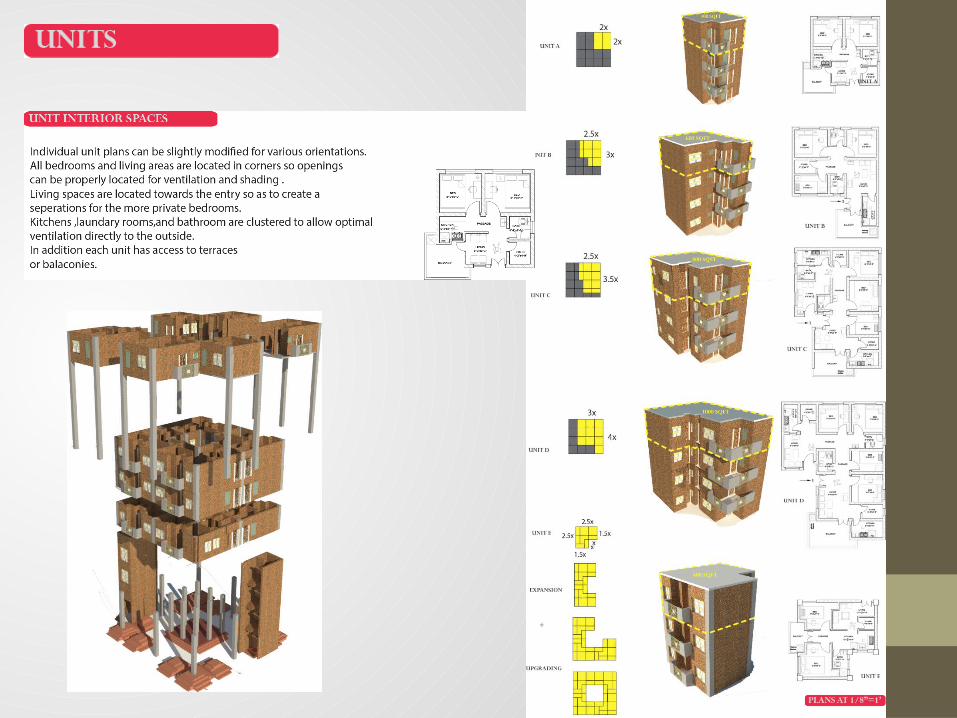
HOUSING

HOUSING

HOUSING


PLANS

LAYOUTS

VIEWS

VIEWS

VIEWS