urban park site selection at local scale by using
TRANSCRIPT
BEPLS Vol 3 Spl Issue IV 2014 11 | P a g e ©2014 AELS, INDIA
Bulletin of Environment, Pharmacology and Life Sciences Bull. Env. Pharmacol. Life Sci., Vol 3 (Spl issue IV) 2014: 11-17 ©2014 Academy for Environment and Life Sciences, India Online ISSN 2277-1808 Journal’s URL:http://www.bepls.com CODEN: BEPLAD Global Impact Factor 0.533 Universal Impact Factor 0.9804
Urban Park Site Selection at Local Scale by Using Geographic Information System (GIS) and Analytic Hierarchy Process (AHP)
1Elahe Tahmasebi, 1Mobina Jalali, 1Marjan Gharehghashlo, 1Milad Nicknamfar, 2Hooman
Bahmanpour
1Department of Architecture, College of Engineering, Science and Research B ranch, Islamic Azad University, Shahrood, Iran
2Department of Environment, College of basic science, Shahrood Branch, Islamic Azad University, Shahrood, Iran
Corresponding author: [email protected]
ABSTRACT The Significance of urban green space situates it among the five important urban uses. Site selection of public green spaces necessitates social requirements. This study aimed at optimal site selection of urban parks at local level in the City of Shahrood. The only option on the table to do so included integrating GIS with Overlaying. First, criteria were incorporated into GIS and new information layers were created, which in turn were employed in conjunction with the existing data to gain information such as conflicting uses (military, industrial) as well as wasteland situation. In so doing, statistics and maps with a scale of 1:10,000 were utilized. After overlaying, four sites were considered as alternatives. In the next step, the determinant criteria were weighted in AHP, and pair wise comparison was conducted in order to discover the optimal alternative to build a local scale park. The results reveal that Site 2 in Area 4 is the best alternative. Keywords: Site Selection, Local Park, GIS, AHP, Shahrood INTRODUCTION Urban green spaces are so important that they are counted among the five significant urban uses [1]. They also play role in tackling urban pollution and providing leisure activities and sport [2]. Parks support the complementary and bilateral relationship between “the nature and culture” or “parks and the city” [3]. To highlight their importance, it is enough to say that nowadays the urban climate, affected by congestion and centralization of activities, is transformed to such an extent that it is taken into account independently when it comes to regional urban studies [4]. The most significant effect of urban green space involves its environmental functions which signify the city as the human society’s environment and combat adverse impacts of industrial development and inappropriate use of technology – hence enhancing urban ecological capability [5]. The urban green space holds so much importance that it finds its position among the development indicators [2]. Some of functions it offers are as follows:
Absorption of CO2 and other toxic gasses and oxygen production; Moderating urban climate [4]; Reducing noise pollution [5]; Boosting individual spirits [4]; Preventing water and wind erosion [5]; Mitigating risks of floods; and Aesthetics and preventing urbanization and suburbanization [6].
The key point in the site selection of public green spaces is social requirements for building a park [7]. Today, urban green spaces and parks are known as Vitamin G [8]. A local scale park is a space within a neighborhood with an area twice as big as a neighborhood scale park – about 1ha. The farthest a child should travel to the former comes to twice as much as that of the latter. On the way to a local park, a child may cross an avenue with fast, but not very fast, traffic. Its users include children and the elderly. Its amenities are tailored to this population as well. Improper site selection of urban green spaces may ultimately lead to low use rate, limitations upon favorable architectural designing, limitations on plant arrangement, urban visual chaos, problems regarding

BEPLS Vol 3 Spl Issue IV 2014 12 | P a g e ©2014 AELS, INDIA
irrigation and soil modification, lack of descent social interactions, management and maintenance issues, mental and social security depletion, etc [2, 4 & 8]. MATERIAL AND METHODS Study area Shahrood County, with an area of 51,419Km, stands the largest county in Semnan Province, located north of the Kavir and south of the Alborz Ranges. It holds, according the 2011’s Census, 238,830 individuals. Since, according to the Master Plan of Shahrood, Area 4 situated within District 1 is the most populated, it needs specific attention in terms of site selection of local parks. It is the furthest western area in District 1, bordering Area 3 westward, Area 2 and Area 6 eastward [9].
Figure 1: the location of the study area globally and in Iran
Data required for this study consisted of local and non-local (descriptive). Urban maps with the scale of 1:10,000, data on the types of land use as well as their area and percentage, and the climate and social characteristics were among the most significant date employed in this study. The following criteria were used for local park site selection:
Proximity to the residential areas Proximity to the urban facilities Distance to the existing local parks Access to transportation Proximity to educational areas Enough distance from incompatible uses such as military, industrial, etc. Site selection in current wastelands
In order to determine the potential of each district within the study area, the only option involved employing GIS along with Overlaying. To do so, the above mentioned criteria were incorporated into GIS to obtain new information layers, and by using existing data, new information such as distance form incompatible uses as well as site selection in current wastelands were produced. Next, the best alternative in terms of park location was chosen by weighting determining criteria in Analytic Hierarchy Process (AHP). AHP is a flexible, simple, and effective method used for decision making when conflicting decision-making criteria complicate seeking the best alternative [10]. Previous studies show that it can be employed in dealing with urban planning because of AHP simplicity and flexibility, simultaneous use of qualitative and quantitative criteria, and judgment consistency [11 & 12]. Analytical Hierarchy Process In the process of site selection, after defining and introducing overall goals, objectives, operational milestones, and alternatives, appraisal is conducted to choose the best alternative [13]. To evaluate relative eligibility of each option, criteria and prioritizing is employed [14]. Structuring a Hierarchy In the first place, structuring involves four levels, including goals, criteria, sub-criteria, and alternatives [14]. Transforming a problem into a hierarchal structure holds the major significance in hierarchical analysis [15]. In this method, each criterion has a certain weight to be employed by the user and can be broken down into smaller components, a sub-criterion, to make a weighted comparison [16].
BEPLS Vol 3 Spl Issue IV 2014 13 | P a g e ©2014 AELS, INDIA
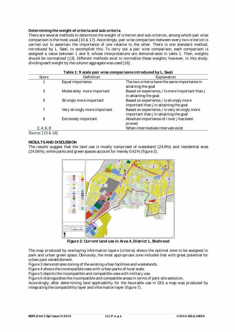
Determining the weight of criteria and sub-criteria There are several methods to determine the weight of criterion and sub-criterion, among which pair wise comparison is the most usual [10 & 17]. Accordingly, pair wise comparison between every two criterion is carried out to ascertain the importance of one relative to the other. There is one standard method, introduced by L. Saati, to accomplish this. To carry out a pair wise comparison, each comparison is assigned a value between 1 and 9, whose interpretations are demonstrated in table 1. Then, weights should be normalized [13]. Different methods exist to normalize these weights; however, in this study, dividing each weight by the column aggregate was used [16].
Table 1: 9 scale pair wise comparisons introduced by L. Saati Score Definition Explanation
1 Equal importance The two criteria have the same importance in attaining the goal
3 Moderately more important Based on experience, i is more important than j in attaining the goal
5 Strongly more important Based on experience, i is strongly more important than j in attaining the goal
7 Very strongly more important Based on experience, i is very strongly more important than j in attaining the goal
9 Extremely important Absolute importance of i over j has been proved
2, 4, 6, 8 When intermediate intervals exist Source: [10 & 18] RESULTS AND DISCUSSION The results suggest that the land use is mostly comprised of wasteland (24.8%) and residential area (24.56%), while parks and green spaces account for merely 0.61% (figure 2).
Figure 2: Current land use in Area 4, District 1, Shahrood
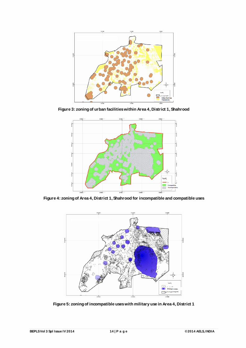
The map produced by overlaying information layers (criteria) shows the optimal zone to be assigned to park and urban green space. Obviously, the most appropriate zone includes that with great potential for urban park establishment. Figure 3 demonstrates zoning of the existing urban facilities and wastelands. Figure 4 shows the incompatible uses with urban parks of local scale. Figure 5 depicts the incompatible and compatible uses with military use. Figure 6 distinguishes the incompatible and compatible areas in terms of park site selection. Accordingly, after determining land applicability for the favorable use in GIS, a map was produced by integrating the compatibility layer and information layer (figure 7).
BEPLS Vol 3 Spl Issue IV 2014 14 | P a g e ©2014 AELS, INDIA
Figure 3: zoning of urban facilities within Area 4, District 1, Shahrood
Figure 4: zoning of Area 4, District 1, Shahrood for incompatible and compatible uses
Figure 5: zoning of incompatible uses with military use in Area 4, District 1

BEPLS Vol 3 Spl Issue IV 2014 15 | P a g e ©2014 AELS, INDIA
Figure 6: Distinguishing incompatible and compatible zones in terms of site selection
Ultimately, 4 sites were considered as alternatives for establishing an urban park at local scale within Area 4, District 1 (figure 8).
Figure 7: Identifying appropriate spots to establish an urban park at local scale

BEPLS Vol 3 Spl Issue IV 2014 16 | P a g e ©2014 AELS, INDIA
Figure 8: four sites considered as alternatives
Finally, Site 4 was chosen as an appropriate location to build the park. AHP was employed to make pair wise comparison between alternatives and choose the best one. In so doing, first, the criteria underwent a pair wise comparison resulting in an inconsistency 0.04 which was acceptable.
Figure 9: pair wise comparison of criteria
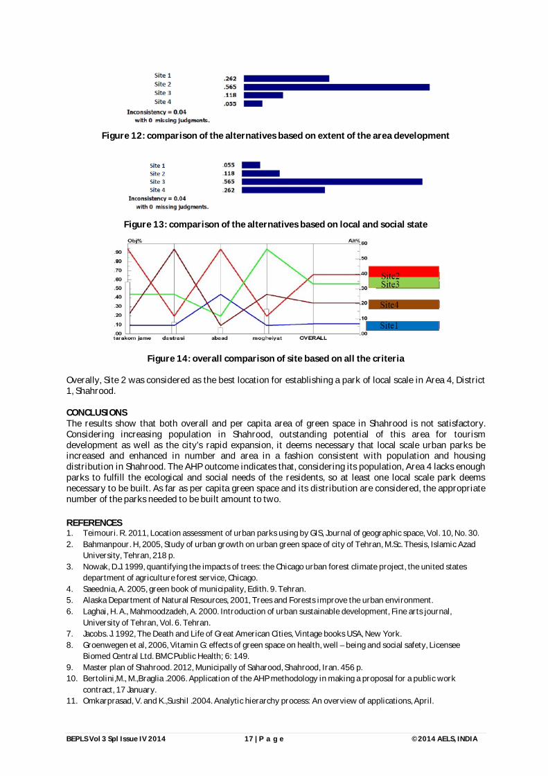
Next, the alternatives were compared in regard to the criteria. Figure 10 demonstrates the comparison between alternatives based on population density on each site; figure 11 shows the result of comparing the alternatives from accessibility point of view; figure 12 displays alternatives based on their development and figure 13 on local and social state. Figure 14 indicates the overall comparison between the four sites.
Figure 10: comparison of the alternatives based on population density
Figure 11: comparison of the alternatives based on accessibility
BEPLS Vol 3 Spl Issue IV 2014 17 | P a g e ©2014 AELS, INDIA
Figure 12: comparison of the alternatives based on extent of the area development
Figure 13: comparison of the alternatives based on local and social state
Figure 14: overall comparison of site based on all the criteria
Overally, Site 2 was considered as the best location for establishing a park of local scale in Area 4, District 1, Shahrood. CONCLUSIONS The results show that both overall and per capita area of green space in Shahrood is not satisfactory. Considering increasing population in Shahrood, outstanding potential of this area for tourism development as well as the city’s rapid expansion, it deems necessary that local scale urban parks be increased and enhanced in number and area in a fashion consistent with population and housing distribution in Shahrood. The AHP outcome indicates that, considering its population, Area 4 lacks enough parks to fulfill the ecological and social needs of the residents, so at least one local scale park deems necessary to be built. As far as per capita green space and its distribution are considered, the appropriate number of the parks needed to be built amount to two. REFERENCES 1. Teimouri. R. 2011, Location assessment of urban parks using by GIS, Journal of geographic space, Vol. 10, No. 30. 2. Bahmanpour. H, 2005, Study of urban growth on urban green space of city of Tehran, M.Sc. Thesis, Islamic Azad
University, Tehran, 218 p. 3. Nowak, D.J. 1999, quantifying the impacts of trees: the Chicago urban forest climate project, the united states
department of agriculture forest service, Chicago. 4. Saeednia, A. 2005, green book of municipality, Edith. 9. Tehran. 5. Alaska Department of Natural Resources, 2001, Trees and Forests improve the urban environment. 6. Laghai, H. A., Mahmoodzadeh, A. 2000. Introduction of urban sustainable development, Fine arts journal,
University of Tehran, Vol. 6. Tehran. 7. Jacobs. J. 1992, The Death and Life of Great American Cities, Vintage books USA, New York. 8. Groenwegen et al, 2006, Vitamin G: effects of green space on health, well – being and social safety, Licensee
Biomed Central Ltd. BMC Public Health; 6: 149. 9. Master plan of Shahrood. 2012, Municipally of Saharood, Shahrood, Iran. 456 p. 10. Bertolini,M., M.,Braglia .2006. Application of the AHP methodology in making a proposal for a public work
contract, 17 January. 11. Omkarprasad, V. and K.,Sushil .2004. Analytic hierarchy process: An overview of applications, April.

BEPLS Vol 3 Spl Issue IV 2014 18 | P a g e ©2014 AELS, INDIA
12. Healey, M., Ilbery, B. 1990. Location and Change: Perspective on Economic Geography. Oxford University Press. 13. Dey,P.K., E.K.,Ramcharan.2000. Analytic hierarchy process helps select site for limestone quarry expansion in
Barbados. Journal of Environmental Management. 14. Changa,K.F., C.M.,Chiangb, P.C.Chouc.2007. Adapting aspects of GB Tool 200`—searching for suitability in Taiwan,
Building and Environment 42 310–316. 15. Çimren,E., B.,Çatay, E.,Budak .2007. Development of a machine tool selection system using AHP, International
Journal of Advanced Manufacturing Technology35 363–376. 16. Sanaei,A., A.,Faraji.2002. Using location –allocation models for regional planning in GIS, Environment, Proceeding
of MAP ASIA, Bangkok. 17. Moreno-Jimenez,J.M., et al.2005. A spreadsheet module for consistent consensus building in AHP-group decision
making, Group Decision and Negotiation 14 89–108. 18. Bowen, W.M.1990. Subjective judgments and data environment analysis in site selection, Computer, Environment
and Urban Systems, Vol. 14, pp.133-144