urban network analysis - singapore university of ... · urban network analysis 289 packages...
TRANSCRIPT

Revue internationale de géomatique – n° 2/2012, 287-305
Urban network analysis
A new toolbox for ArcGIS Andres Sevtsuk1, Michael Mekonnen2 1. Singapore University of Technology & Design, City Form Lab
20 Dover Drive, Singapore, 138682 [email protected]
2. Massachusetts Institute of Technology MacGregor House # C122 Building W61 450 Memorial Drive, Cambridge, MA 02139 [email protected]
ABSTRACT. This paper introduces an open-source Urban Network Analysis (UNA) toolbox for ArcGIS. The toolbox can be used to compute five types of network centrality measures on spatial networks: Reach; Gravity Index; Betweenness; Closeness; and Straightness. Though primarily developed for the analysis of urban street- and building-networks, the tools are equally suited for other spatial networks, such as railway networks, highway networks, or utility networks. Unlike previous network centrality tools that operate with two network elements (nodes and edges), the UNA tools include a third network element – buildings – that can be used as the spatial units of analysis for all measures. Two neighboring buildings on the same street segment can therefore obtain different accessibility results. The UNA tools also allow buildings to be weighted according to their particular characteristics – more voluminous, more populated, or otherwise more important buildings can be specified to have a proportionately stronger effect on the analysis outcomes, yielding more accurate and reliable results to any of the specified measures. The toolbox is built for easy scaling – it can operate on small-scale and detailed networks of dense urban areas, as well as large-scale regional networks. The toolbox requires ArcGIS 10 software with an ArcGIS Network Analyst Extension. RÉSUMÉ. Cet article présente l’utilitaire open source « Analyse d’un réseau urbain », ou UNA (Urban Network Analysis), pour ArcGIS. L’utilitaire permet de calculer cinq types de mesures de centralité sur des réseaux spatiaux : Reach, Gravity Index, Intermédiarité, Proximité et Straightness. Bien qu’ils aient été développés avant tout pour analyser des réseaux de rues ou de bâtiments en contexte urbain, les outils sont adaptés également à l’étude d’autres réseaux spatiaux, comme des réseaux ferroviaires, autoroutiers ou de services. À la différence des utilitaires de calcul de centralité existant précédemment, qui prenaient en compte deux éléments du réseau (les nœuds et les arêtes), les outils UNA intègrent un troisième type d’éléments – les bâtiments – qui peuvent être utilisés comme unités d’analyse spatiale pour toutes les mesures. Les outils UNA permettent aussi de

288 RIG. Volume 22 – n° 2/2012
pondérer les bâtiments en fonction de leurs caractéristiques particulières : les bâtiments plus gros, plus peuplés, ou plus importants pour quelque autre raison, peuvent être spécifiés et avoir un effet proportionnellement plus important sur les résultats de l’analyse, ce qui permet d’obtenir des résultats plus précis et plus fiables pour chacune des mesures opérées. L’utilitaire permet des changements d’échelle faciles : il peut être appliqué à des réseaux à petite échelle et haut niveau de détail dans les zones urbaines denses aussi bien qu’à des réseaux régionaux à grande échelle. L’utilitaire nécessite le logiciel ArcGIS 10 avec une extension pour l’analyse des réseaux (ArcGIS Network Analyst Extension). KEYWORDS: spatial networks, city form, GIS, centrality, accessibility, spatial analysis. MOTS-CLÉS : réseaux spatiaux, forma urbaine, GIS, centralité, accessibilité, analyse spatiale.
DOI:10.3166/RIG.22.287-305 © 2012 Lavoisier
1. Introduction
Though the study of spatial networks goes back to Euler and his famous puzzle of Königsberg’s seven bridges in the 18th century, a surge in the application of network analysis methods in urban and regional studies has only occurred in the past decade (Turner, 2001; Porta et al., 2008; Hu et al., 2008; Crucitti et al., 2006; Scheurer et al. 2007, Jiang and Liu, 2011; Stahles et al., 2007; Ozbil and Peponis, 2011). Important foundations for spatial network analysis methods and measurement indices were developed decades ago (Kansky, 1963; Hagget and Chorley, 1969; Tabor, 1976; Hillier and Hanson, 1984), but their application was till recently computationally too expensive on even small-scale networks.
Research has shown that network analysis measures can be useful predictors for a number of interesting urban phenomena. They have been helpful in explaining the importance of particular junctions in transportation networks (Garrison, 1960; Garrison and Marble, 1962; Kansky, 1963; Haggett and Chorley, 1969), the connectedness of rooms inside buildings (Levin, 1964; Casalania and Rittel, 1967; Rittel, 1970; March and Steadman, 1971), the flow of pedestrian traffic on city streets (Hillier et al., 1987), and the distribution of retail and service establishments in urban environments (Porta et al., 2005; Sevtsuk, 2010). As pervasive geographic data are becoming available in cities around the world, new and readily accessible tools are needed to make network analysis available to spatial analysts across disciplines.
This paper introduces a new open-source toolbox for spatial network analysis in ArcGIS. There have been other elegant efforts to develop freely accessibly GIS toolboxes for spatial network analyses, most notably the Axwoman toolbox developed by Jiang et al. (1999); the SANET toolbox developed by Okabe (Okabe and Sugihara, 2012), and other custom built applications for GIS (Miller and Wu, 2000 ; Jiang and Claramunt, 2002 ; Peponis and Bafna, 2008). Several spatial network analysis programs have also been developed as stand-alone proprietary

Urban network analysis 289
packages (Turner, 2001; Porta et al., 2005; TransCAD)1. The Urban Network Analysis toolbox presented in this paper includes a number of features that complement the previous work by offering a novel representational framework, new network indices, and by making network centrality measurement accessible to a broad audience via a free and open-source toolbox built for the ArcGIS 10 software platform.
The paper will first introduce the network representation framework used in the toolbox, and explain the innovations it presents compared to the presently available alternatives. We then describe the five centrality indices offered in the toolbox and explain the computational process behind the calculations. Examples of applications of the toolbox are shown along the way, using data from Cambridge and Somerville, MA as an example.
2. Network representation of the built environment
Most spatial network studies to date have represented networks using two types of network elements – nodes and edges. In the case of urban street networks, edges typically represent street segments, and nodes the junctions where two or more edges intersect (Porta et al., 2005). This has become known as the primal representation of spatial graphs. Some analysts invert this representation, illustrating street segments as nodes and junctions as edges, known as the dual representation. Dual graphs are used in the Space Syntax methodology, for instance (Hillier, 1996). The important distinction between the primal and dual approaches lies in the way that the underlying graph is represented, and consequently in the interpretation of the indices that are used to measure the relationships between graph elements. Whereas primal representation of graphs typically use metric distances to describe inter-relationships between graph elements, the dual representation usually focus on topological distance measures (i.e. the number of connections, rather than the length of connections) between graph elements. At root, the two representations describe similar phenomena and the units of analysis in both cases can be either nodes or edges. The analysis results illustrate the degree to which an edge or node is spatially connected to the surrounding path network.
This approach economizes computation power and allows the analysis to be applied on large networks. But the exclusive focus on nodes and edges also poses some difficulties for the theoretical interpretation and practical applicability of the results in real urban settings. First, buildings, which accommodate activities where most urban trips begin and end, are missing from the picture. This makes the results of the analysis theoretically difficult to interpret. What does the connectivity of a street tell us if buildings are not accounted for? Whether the objective of the analysis is traffic flow, business location choice, or land values, buildings accommodate most
1. TransCAD is a GIS-based transportation analysis software package produced by Caliper. For more reference, see: http: // www. caliper.com/tcovu.htm (accessed September 20, 2011).

290 RIG. Volume 22 – n° 2/2012
urban activities and act as the crucial origins and destinations of urban movement. Edges and nodes of the street network are spaces that accommodate traffic, which flows between buildings. Graph representations of nodes and edges thus ignore the important variations in built density and land-use distribution that characterize actual built environments.
Second, since a great deal of urban decision making happens at the building level, then the node or edge level results can also be difficult to use in practice. With edges as units of analysis, all activities or buildings located along a given street segment obtain identical values of accessibility. A building located at the corner of a major intersection is attributed the same level of accessibility as a building in the middle of a block, effectively ignoring local differences that could play an important role in actual built environments.
Third, most urban graph representations to date have been used in unweighted form, treating each element of the network (e.g. edge or node) as equal. Unweighted representation of network elements may simplify the analysis, but it also conceals important hazards. An unweighted urban network implies that a street that has no buildings on it is weighted equally with a street that accommodates a number of skyscrapers. Likewise, an area covered with industrial land uses, for instance, is weighted equally with an area that accommodates commercial land uses. Unweighted node-edge representations of urban street networks strictly limit the analyses to the geometric properties of the street network itself, ignoring all information about the buildings and activities located on these streets.
In order to address these shortcomings, the UNA toolbox introduces two important modifications to the network representation of the built environment. First, we add buildings (or other location instances, such as land parcels, transit stations etc.) to the representation, adopting a tripartite representation that consists of three basic elements: edges, representing paths along which travelers can navigate; nodes, representing the intersections where two or more edges intersect; and buildings, representing the locations where traffic from streets enters into indoor environments or vice versa. Our unit of analysis thus becomes a building, enabling the different graph indexes to be computed separately for each building. This allows us to account for both uneven building densities and land use patterns throughout the network, neither of which are addressed in most current urban network analysis methods. We assume each building connects to a street (edge) that lies closest to it along the shortest perpendicular connection from the centroid of its footprint2. This representation is conveniently suited for the ArcGIS Network Analyst extension, where origins and destinations of travel paths are represented with geographically
2. Mapping buildings to the network using centroids can admittedly include some error, as a building’s centroid may lie closer to a side street rather than its main street entrance. We are working on improving this aspect of determining buildings’ network locations by allowing a user to choose between a centroid and a closest vertex to a street segment.

Urban network analysis 291
positioned points3. Should the analyst wish to compute the graph centrality measures for nodes of the network instead of buildings, then the nodes themselves can be used as inputs instead of buildings.
Second, the UNA toolbox introduces a weighted representation of spatial network elements. Each building obtains a set of attributes that connect the building in the graph with the true characteristics of the corresponding structure in the city. The attributes can capture any measurable properties of the structures around them: their size, establishment mix, number of residents or jobs, height, etc. The weighted representation of buildings thus opens up a range of options for studying different kinds of spatial relationships between buildings in a network of city streets. This network representation framework is illustrated in Figure 1. The left side of the figure presents a fragment of Harvard Square in Cambridge MA in plan drawing. The same plan drawing is shown in graph form on the right.
Figure 1. Left: Plan drawing of Harvard Square in Cambridge, MA. Right: a graph representation of the same plan drawing
If the spatial configuration of the environment under study cannot be represented in a two-dimensional graph – as may be the case if the network contains underpasses, overpasses, or three-dimensional circulation routes inside buildings – then a similar graph can also be represented three dimensionally. Network Analyst in ArcGIS10 supports three-dimensional spatial networks using vertical z-axis values on each of the network elements.
3. In order to accurately model buildings that have multiple entrances on different streets, a user can provide a different input point for each entrance and divide the total attribute weights of the corresponding building by the number of entrances used. The end result of multiple entrance points belonging to the same building should be summed.

292 RIG. Volume 22 – n° 2/2012
3. Network centrality measures
Network centrality measures are mathematical methods of quantifying the importance each node in a graph. As the name implies, centrality metrics focus primarily on how centrally each graph element is located with respect to the surrounding elements. Graph centrality metrics are analogous to spatial accessibility measures, but applied on network rather than Euclidian space (Bhat et al., 2000). The Urban Network Analysis toolbox can be used to compute five different types of centrality metrics on spatial networks – Reach, Gravity Index, Betweenness, Closeness, and Straightness – as shown in the graphic user interface of the toolbox in Figure 2. We describe each of these five metrics in detail below.
The Search Radius input specified in the user interface defines the network radius at which the metrics are computed. For each input building, only those other buildings, whose geodesic distance from the given building is less or equal to the specified Search Radius, are considered in the analysis. If no Search Radius is defined, then the default infinite radius is used to reach all other buildings in the graph.
Figure 2. The graphic user interface of the UNA toolbox

Urban network analysis 293
3.1. Reach
The reach centrality of a node in a graph at a search radius , describes the number of other nodes in that are reachable from at a shortest path distance of at most . It is defined as follows:
(1)
where is the shortest path distance between nodes and in , and is the weight of a destination node .4 The weights can represent any numeric attribute of the destination buildings – their size, the number of employees they contain, the number of residents they accommodate etc. Using weights allows the analyst to compute how many of such attributes (e.g. residents, jobs) can be reached from each building within a given network radius.
Figure 3 illustrates how the Reach index works visually. An accessibility buffer is traced from the building of interest 𝑖 in every direction on the street network until the limiting radius r is reached. The Reach index is then computed as the number of destinations j that are found within the radius. If weights are specified, then the sum of weights is counted instead of the number of destinations. In Figure 3, location i reaches twenty surrounding locations in radius r .
Figure 3. Visual illustration of the reach index
Figure 4 illustrates the Reach measure with a radius of 600 meters applied to buildings in Cambridge and Somerville, MA, weighted by building volume. The 4 The Reach metric is equivalent to the cumulative opportunities type accessibility measure discussed in Bhat, Handy et al. (2002), but applied on a network rather than Euclidian space. In name, our Reach measure also resembles Peponis’ and his colleagues reach measure (2008), but the latter measures the cumulative length of streets rather than the opportunities located on these streets.

294 RIG. Volume 22 – n° 2/2012
output illustrates how much surrounding built volume can be reached from each building in a 600-meter walking radius. We see that higher Reach values result in areas, where buildings are larger, more densely spaced, or where the street network is denser. Along Massachusetts Avenue near MIT, a typical building reaches roughly 50 million cubic feet of built space in a 600-meter walking radius. In a residential area around Fresh Pond, ten times less volume can be reached during the same walk.
Figure 4. Reach to built volume within a 600-meter network radius from each building in Cambridge & Somerville, MA.
(Building volume data source: MassGIS 2002)
The proposed Reach measure may be interpreted as an alternative to areal density measures (e.g. households per acre, or jobs per square kilometer), which accounts for opportunities that are reachable along the actual street network as perceived by a pedestrian, bike or vehicle. The particular network input and Search Radius r used in the analysis allow the user to model the index from the perspective of different transportation modes5. We have shown elsewhere that the Reach to built volume, depicted in Figure 4, can be a significant predictor for retail and service
5. A 600m Search Radius, for instance, allows one to estimate an approximately ten-minute network travel radius from a pedestrian viewpoint, but a different network and several kilometers can be used in a Search Radius that estimates the same time-budget for vehicles.

Urban network analysis 295
establishments’ location choices, even in the presence of numerous covariates (Sevtsuk, 2010).
3.2. Gravity index
Whereas the Reach measure simply counts the number of destinations around each building within a given Search Radius (optionally weighted by building attributes), the Gravity measure additionally factors in the spatial impedance required to reach each of the destinations. First introduced by Hansen (1959), the Gravity index remains one of the most popular spatial accessibility measures in transportation research.
The gravity index, of a node in graph at a radius is based on the intuition that centrality is inversely proportional to the shortest path distance between and each of the other nodes in that are reachable from within a geodesic distance . It is defined as follows:
(2)
where is the exponent that controls the effect of distance decay on each shortest path between and and is the weight of a particular destination that is reachable from within the radius threshold . If beta is set to zero, then no distance effect is applied and the Gravity Index becomes equivalent to Reach. If the buildings in are weighted, then the Gravity Index is directly proportional to the weight of each of the other buildings that can be reached within the given search radius.
The exponent β in the Gravity Index controls the shape of the distance decay function, that is, how strongly the distance between 𝑖 and its neighbouring destinations j affects the result. The specification of β must thus depend on both the mode of travel assumed in the analysis (e.g. walking, cycling, driving), as well as the units of distance measurement. An empirical study of pedestrian trips to convenience stores in Oakland, CA by Handy and Niemeier (1997) has suggested that for walking distances, measured in minutes, β is approximately 0.18136.
6. The equivalent value of Beta for distance units in “meters” is 0.00217; in “feet” 0.000663; in “kilometers” 2.175, and in “miles” 3.501.

296 RIG. Volume 22 – n° 2/2012
Figure 5 illustrates how the Gravity Index is applied to the same dataset in Cambridge and Somerville MA as above, using building volumes as weights, and a 600-meter Search Radius. Since the index is sensitive to distance, we see how the values are less spread out than in the case of Reach and more concentrated around areas where building volumes are large, the path network dense, and the buildings spaced at close intervals to each other7. The gravity index offers a powerful measure that combines the number of destinations, the attractiveness of the destinations, and the travel costs of reaching these destinations into a single value. In previous applications it has been widely used to land use distribution and rent in Euclidian space (Hansen, 1959), it forms the basis of Huff’s retail location choice model (Huff, 1963), and different forms of it have been used to estimate employment distribution (Waddell, 2003; Erlander and Stewart, 1990). Our application of the Gravity Index on networks could allow for similar applications with higher accuracy and a behavioral grounding, that is close to people’s true perception of city environments.
Figure 5. Gravity Index measured to built volume within a 600-meter network
radius (Beta=0.00217) from each building to every other building in Cambridge & Somerville, MA
7. These three factors – the sizes of buildings, the density of their spacing, and the density of street network connecting them – are the primary urban design variables that affect network accessibility to all surrounding built volume or floor area. Access to built volume at any given building can only change if any or all of these factors change.

Urban network analysis 297
3.3. Betweenness
The betweenness centrality, , of a building in graph estimates the number of times lies on shortest paths between pairs of other reachable buildings in that lie within the network radius (Freeman 1977). If more than one shortest path is found between two buildings, as is frequently the case in a rectangular grid of streets, then each of the equidistant paths is given equal weight such that the weights sum to unity. It is defined as follows:
(3)
where is the number of shortest paths from building to building in , and
is the subset of these paths that pass through , with and lying within the network radius from , and is the weight of a particular destination . As the name suggests, the Betweenness measure may be used to estimate the potential of passersby at different locations of the network. If the analysis is weighted by demographics of a certain type in the surrounding buildings for instance, then Betweenness centrality can capture the potential of passersby of that particular demographic at building i. Adjusting the Search Radius from a ten-minute walking range to a ten-minute driving range, allows the user to measure Betweenness for different traffic modes.
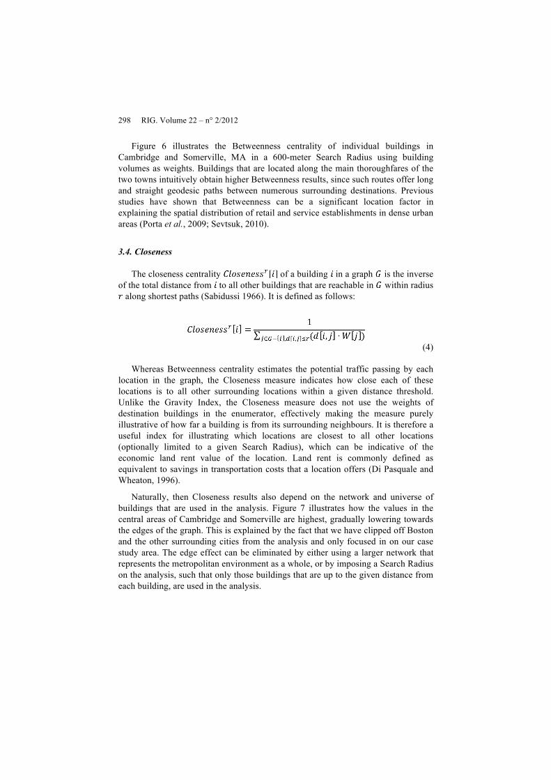
Figure 6. Betweenness centrality in a 600-meter network radius, weighted by
building volume in Cambridge & Somerville, MA
298 RIG. Volume 22 – n° 2/2012
Figure 6 illustrates the Betweenness centrality of individual buildings in Cambridge and Somerville, MA in a 600-meter Search Radius using building volumes as weights. Buildings that are located along the main thoroughfares of the two towns intuitively obtain higher Betweenness results, since such routes offer long and straight geodesic paths between numerous surrounding destinations. Previous studies have shown that Betweenness can be a significant location factor in explaining the spatial distribution of retail and service establishments in dense urban areas (Porta et al., 2009; Sevtsuk, 2010).
3.4. Closeness
The closeness centrality of a building in a graph is the inverse of the total distance from to all other buildings that are reachable in within radius
along shortest paths (Sabidussi 1966). It is defined as follows:
(4)
Whereas Betweenness centrality estimates the potential traffic passing by each
location in the graph, the Closeness measure indicates how close each of these locations is to all other surrounding locations within a given distance threshold. Unlike the Gravity Index, the Closeness measure does not use the weights of destination buildings in the enumerator, effectively making the measure purely illustrative of how far a building is from its surrounding neighbours. It is therefore a useful index for illustrating which locations are closest to all other locations (optionally limited to a given Search Radius), which can be indicative of the economic land rent value of the location. Land rent is commonly defined as equivalent to savings in transportation costs that a location offers (Di Pasquale and Wheaton, 1996).
Naturally, then Closeness results also depend on the network and universe of buildings that are used in the analysis. Figure 7 illustrates how the values in the central areas of Cambridge and Somerville are highest, gradually lowering towards the edges of the graph. This is explained by the fact that we have clipped off Boston and the other surrounding cities from the analysis and only focused in on our case study area. The edge effect can be eliminated by either using a larger network that represents the metropolitan environment as a whole, or by imposing a Search Radius on the analysis, such that only those buildings that are up to the given distance from each building, are used in the analysis.

Urban network analysis 299
Figure 7. Closeness centrality to surrounding buildings with no limiting radius and no weights in Cambridge & Somerville, MA
3.5. Straightness
The straightness centrality, , of a building in a graph illustrates how closely the shortest network distances between and other buildings in that are reachable within radius , resemble Euclidean distances (Vragovic, Louis et al. 2005; Porta et al., 2005). It is defined as follows:
(5)
Where δ[𝑖 , j] is the as-a-crow-flies distance between buildings 𝑖 and j, d[𝑖 , j] the shortest network distance between the same buildings, and W[j] the weight of destination j. As a ratio between the Euclidian distance and the geodesic distance from each location 𝑖 to the surrounding locations j, Straightness can only be estimated if the units of impedance are in linear distance (e.g. miles), not time (e.g. minutes) or topological units (e.g. turns).

300 RIG. Volume 22 – n° 2/2012
Figure 8. Straightness centrality with no limiting radius, weighted by building volume in Cambridge & Somerville, MA
Figure 8 illustrates how Straightness too, like Betweenness, picks up the buildings along some of the longest and straightest thoroughfares in the network. This is because such locations offer more direct travel routes to all their neighbours than buildings along less continuous streets. The reader might imagine an extreme case of straightness at the Arc de triomphe in Paris, where 12 long streets radiate from single central structure. Straightness can thus be useful as a measure for detecting place that are most directly connected to their surrounding built fabric, with applications in economizing urban infrastructure (e.g. bike paths), or detecting high landmarks or nodes that are visible from far distances (Lynch, 1960).
However, Figure 8 also indicates that Straightness centrality increases as the mean distance to surrounding destinations increases. The highest values in the buildings along the periphery of Cambridge and Somerville suggest that longer network paths tend to resemble straight lines more closely than shorter network paths – a walk from Kendall Square in Cambridge to Copley Square in Boston along the street network is 90% longer than the crow-flies-distance between the two squares, but a walk from Kendall to Times Square in Manhattan is only 18% longer than a straight line between the two squares.

Urban network analysis 301
4. Transportation costs
The UNA toolbox is designed to handle a variety of different impedance attributes to model transportation costs. These can include metric distance (e.g. kilometers); topological distance (e.g. turns); and time distance (e.g. minutes). The impedance attributes that are available as inputs to the toolbox are obtained from the input network, they therefore need to be pre-coded into the input network that is used8. In case of kilometers, for instance, the different centrality measures are computed with a limiting radius in kilometers. The Reach centrality will thus be limited to only neighboring buildings that can be reached within the specified number of kilometers (e.g. 2 km). In case of a topological impedance attribute, such as turns, a limiting radius of two turns would instead limit the analysis to all neighboring buildings that are less or equal to two turns away from each origin building9. This allows the toolbox to perform both topological graph analysis, commonly used in the Space Syntax approach (Hillier, 1996), as well as metric graph analysis that is more familiar to transportation researchers (Rodrigue et al., 2006), making the useful for a variety of different applications.
5. Calculation steps of the toolbox
When using the toolbox to compute any of the five centrality metrics, six calculation steps are typically traversed in order to yield the results (Figure 4). First, an adjacency matrix is computed between all input buildings in the graph. The adjacency matrix represents neighbor relationships and distances between a building 𝑖 and every one of its immediately closest neighboring buildings j along all available circulation routes that originate from 𝑖. Since this step can be computationally rather expensive, if the same network dataset, input points, and building identifiers are used for more than once, then the adjacency matrix is automatically reused from the previous run. Second, a graph is constructed from the adjacency matrix. Third, if weights are specified, then building-weight attributes are retrieved from the input points file so that they can be used as part of the centrality computations. Fourth, the centrality computation is run to calculate all the specified metrics. The UNA toolbox uses a highly efficient algorithm for computing the centrality measures, originally developed by Brandes (2001) for computing Betweenness centrality. In step five, the results of the centrality computation are registered in a table and written to an output layer. Finally, in step six, the analysis results are visualized in the ArcMap environment.
8. GIS Network Analyst offers a variety of options for adding different transportation cost attributes to network datasets. 9. Note that turns can be defined in a number of ways. One approach for coding turns to network datasets in ArcGIS is shown in Sevtsuk (2010), Appendix One.

302 RIG. Volume 22 – n° 2/2012
Figure 9. Computation steps of the Urban Network Analysis toolbox
6. Discussion
The immediate value of the Urban Network Analysis toolbox is that it provides architects, planners, geographers and other scholars of the built environment an opportunity to measure accessibility and centrality on spatial networks, which remain prohibitively labor intensive without computers and accessible software. The UNA toolbox operates in the widely popular ArcGIS environment. Applications for network measures offered in the toolbox are rapidly growing with the increasing availability of geospatial data and improvements in computational power.
Such measures allow one to investigate how urban form and activity patterns accommodated therein interact with each other. By focusing on the effects of urban form, land use patterns, or a combination thereof, each attribute of a city can be measured independently and intuitively under the constraints of urban geometry. Weighing the centrality metrics by built volume, as shown in the applied examples above, focuses the analysis exclusively on the two- and three-dimensional geometry of urban form. The outcomes of centrality metrics are in this case entirely determined by the spatial configuration of the built environment and can only be altered if the buildings, streets, or intersections of the environment are altered. Setting the weights on jobs, on the other hand, centers the outcomes on the spatial accessibility to jobs that are hosted within the built fabric. Using various weights, search radii and impedance units allows an analyst to study spatial relationships between numerous urban processes in an intuitive manner, similar to the actual perception of the urban built environment. Using built form measures side by side with land use measures allows one to estimate the importance of each factor on an outcome of interest, while controlling for important covariates. The toolbox thus combines the historically separate approaches of graph analysis and land-use accessibility analysis into a combined framework (Bhat et al., 2000; Batty, 2009), and thereby opens up new empirical ground for both fields of study.

Urban network analysis 303
In future work, it would be desirable to explore the use of the toolbox with multimodal transportation networks (e.g. a combination of public transit and walking, or driving and walking). Since the toolbox operates within ArcGIS and Network Analyst, it can already operate with multimodal networks. In order to use multimodal networks, the Input Network Dataset needs to be accordingly configured.
We also plan to offer an option to limit the estimation of trips to select origin locations, for which the analysis may be desired. This would allow the toolbox to compute accessibility indices for only a few origins, while keeping all destinations available. For the Betweenness measure, this would additionally allow the analysis to estimate trips from only particular building types (e.g. residential buildings) to particular destination types (e.g. subway stations), while keeping track of the same Betweenness estimate at all buildings between the origins and destinations. We think these improvements could open up numerous novel research questions and offer real-world benefits for project impact estimations.
The toolbox is distributed in open-source form. Each download comes along with the latest source code and we invite all interested researchers to contribute to the further development of these tools10.
Bibliography
Batty M. (2009). Accessibility: in search of a unified theory. Environment and Planning B, Vol. 36, No. 2, p. 191-194.
Bhat C., Handy S., Kockelman K., Mahmassani H., Chen Q., Weston L. (2000). Development of an Urban Accessibility Index: Literature Review, Center for Transportation Research, University of Texas at Austin.
Brandes U. (2001). A faster algorithm for betweenness centrality. Journal of Mathematical Sociology, Vol. 25, No. 2, p. 163-177.
Casalania V., Rittel H. (1967). Generating Floor Plans from Adjacency Matrices, MIT, Cambridge, MA.
Crucitti P., Latora V., Porta S. (2006). Centrality in Networks of Urban Streets. Chaos, Vol. 16, No. 1.
Di Pasquale D., Wheaton W.C. (1996). Urban economics and real estate markets. Englewood Cliffs, NJ, Prentice Hall.
Erlander S., Stewart N.F. (1990). The Gravity Model in Transportation Analysis - Theory and Extensions. Topics in Transportation, VSP Books.
Freeman L.C. (1977). A set of measures of centralitybased on betweenness. Sociometry, 40, p. 35-41.
10. Instructions for open-source development can be found on the City Form Lab website: http://cityform.mit.edu/projects/urban-network-analysis.html

304 RIG. Volume 22 – n° 2/2012
Garrison W.L., Marble D.F. (1962). The Structure of Transportation Networks. USAT Command, U.S. Army Transportation Command Technical Report.
Garrison W.L. (1960). Connectivity of the Interstate Highway System. Regional Science Associations, Papers and Proceedings, 6, p. 121-137.
Haggett P., Chorley J.C. (1969). Network Analysis in Geography. London: Butler & Tanner Ltd..
Handy S., Niemeier A.D. (1997). Measuring Accessibility: an exploration of issues and alternatives. Environment and Planning A, 29, p. 1175-1194.
Hansen W.G. (1959). How Accessibility Shapes Land Use. Journal of the American Planning Association, Vol. 25, No. 2, p. 73-76.
Hillier B. (1996). Space is the Machine: A Configurational Theory of Architecture, Cambridge; New York, NY, USA, Cambridge University Press.
Hillier B., Burdett R., Peponis J., Penn A. (1987). Creating Life: Or, Does Architecture DetermineAnything? Architecture et Comportement/Architecture and Behavior, Vol. 3, No. 3, p. 233-250.
Hu Y., Wu Q., Zhu D. (2008). Topological Patterns of Spatial Urban Street Networks. Wireless Communications, Networking and Mobile Computing, WiCOM 4th International Conference.
Huff D. (1963). A Probabilistic Analysis of Shopping Center Trade Areas. Land Economics, Vol. 39, No. 1, p. 81-90.
Jiang B., Claramunt C., Batty M. (1999). Geometric accessibility and geographic information: extending desktop GIS to space syntax. Computers, Environment and Urban Systems, Vol. 23, No. 2, p. 127-146.
Jiang B., Liu X. (2011). Computing the fewest-turn map directions based on the connectivity of naturalroads. International Journal of Geographical Information Science, Vol. 25, No. 7, p. 1069-1082.
Jiang B. and Claramunt C. (2002). Integration of space syntax into GIS: new perspectives for urbanmorphology. Transactions in GIS, Vol. 6, No. 3, p. 295-309.
Kansky K.J. (1963). Structure of Transportation Networks: Relationships Between Network Geometry and Regional Characteristics, University of Chicago, Chicago, IL.
Levin P.H. (1964). The Use of Graphs to Decide the Optimum Layout of Buildings. Architects’ Journal, 7 October.
Lynch K. (1960). The image of the city. Cambridge, MIT Press.
March L., Steadman P. (1971). The Geometry of Environment: An Introduction to Spatial Organization in Design, London, RIBA Publications.
Miller H.J., Wu Y.-H. (2000). GIS Software for Measuring Space-Time Accessibility in Transportation Planning and Analysis. Geoinformatica, Vol. 4, No. 2, p. 141-159.
Newman M.J. (2010). Networks: An Introduction. Oxford University Press, USA, p. 720.

Urban network analysis 305
Okabe A., Sugihara K. (2012). Spatial Analysis Along Networks: Statistical and Computational Methods. Statistics in Practice, p. 296, Wiley.
Ozbil A., Peponis J., Stone B. (2011). Understanding the link between street connectivity, land use and pedestrian flows. Urban Design International, 16, p. 125-141.
Peponis J., Bafna S., Yang Z. (2008). The connectivity of streets: reach and directional distance. Environment and Planning B: Planning and Design 35, p. 881-901.
Porta S., Crucitti P., Latora V. (2005). The network analysis of urbanstreets: a primal approach. Environment and Planning B, Vol. 35, No. 5, p. 705-725.
Porta S., Crucitti P., Latora V. (2008). Multiple centrality assessment in Parma: a network analysis of paths and open spaces. Urban Design International, 13, p. 41-50.
Porta S., Strano E., Iacoviello V., Messora R., Latora V., Cardillo A., Wang F. et al. (2009). Street centrality and densities of retail and services in Bologna, Italy. Environment and Planning B: Planning and Design, 36, p. 450-465.
Rittel H. (1970). Theories of Cell Configuration. Emerging methods in environmental design and planning. Proceedings of the Design Methods Group first international conference, G. T. Moore (Ed.), Cambridge, MA, MIT Press.
Rodrigue J.-P., Comtois C., Slack B. (2006). The geography of transport systems. Abingdon, Oxon, England, New York, Routledge.
Sabidussi G. (1966). The centrality index of a graph. Psychmetrika, 31, p. 581-603.
Scheurer J., Curtis C., Porta S. (2007). Spatial Network Analysis of Public Transport Systems: Developing a Strategic Planning Tool to Assess the Congruence of Movement and Urban Structure in Australian Cities. Australasian Transport Research Forum, Melbourne, 25-27 September.
Sevtsuk A. (2010). Path and Place: A Study of UrbanGeometry and Retai lActivity in Cambridge and Somerville, MA. PhD Dissertation, MIT Department of Urban Studies and Planning, Cambridge.
Stahle A., Marcus L., Karlstrom A. (2007). Place Syntax Tool- GIS Software for Analyzing Geographic Accessibility with Axial Lines. In A Turner (Ed.), p. 35-42. Istambul: Istanbul Technical University.
Tabor P. (1976). Networks Distances and Routes. Geometry of Environment: An Introduction to Spatial Organization in Design, L. March (Ed.), p. 366-367. Cambridge, MIT Press.
Turner Alasdair (2001). Depthmap: A Program to Perform Visibility Graph Analysis. 3rd International Symposium on Space Syntax. Georgia Institute of Technology, 7-11 May.
Vragovic I., Louis, E. Diaz-Guilera, A. (2005). Efficiency of information transfer in regular and complex networks. PhysicsReview E., 71(026122).
Waddell P., Ulfarsson G.F. (2003). Accessibility and Agglomeration: Discrete-Choice Models of Employment Location by Industry Sector. Washington DC.
Wasserman S., Faust K. (1994). Social Network Analysis: Methods and Applications. Structural Analysis in the Social Sciences, p. 857, Cambridge University Press.
