urban morphological zones for spain - Český statistický úřad · 2015-02-09 · urban...
TRANSCRIPT

1

Urban Morphological Zones for Spain: Urban indicators from and Object Oriented Land
Cover data base and a population grid
(in progress…)
Francisco J. Goerlich, University of Valencia and Ivie
Isidro Cantarino, Polytechnic University of Valencia
2
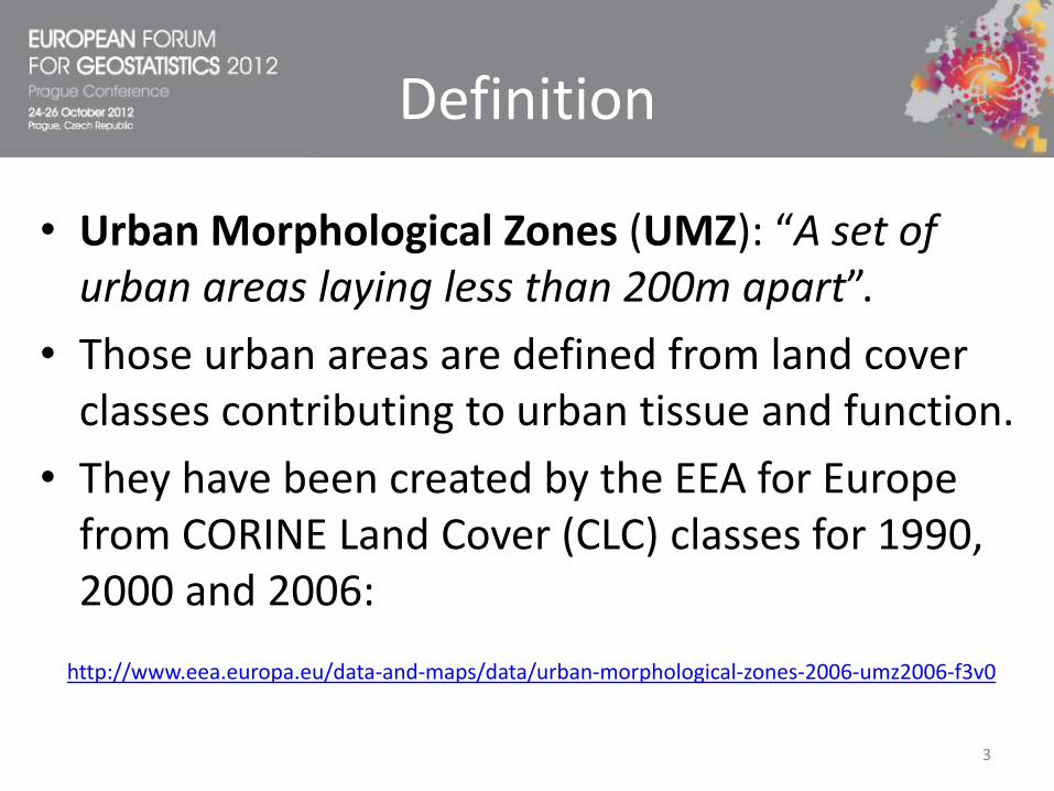
Definition
• Urban Morphological Zones (UMZ): “A set of urban areas laying less than 200m apart”.
• Those urban areas are defined from land cover classes contributing to urban tissue and function.
• They have been created by the EEA for Europe from CORINE Land Cover (CLC) classes for 1990, 2000 and 2006:
http://www.eea.europa.eu/data-and-maps/data/urban-morphological-zones-2006-umz2006-f3v0
3

Objective
• Create UMZ from high resolution land cover information (no reference to LAU2 boundaries).
• Use the EEA methodology, conveniently adapted to the structure of our data.
• Assign to each UMZ population figures from a population grid.
• Eventually, explore the possibility of developing urban indicators from the land cover dataset.
4

Information
1. High resolution and complex land cover dataset: Information System on Land Cover in Spain (SIOSE). An object oriented database developed by our National Geographical Institute (IGN).
2. A 1 Km² population grid: constructed by top-down methods from SIOSE and census track population data for 2006 (presented at the EFGS 2012 Lisbon meeting).
5

SIOSE versus CLC
• Cartographic scale:
1:25.000 SIOSE versus 1:100.000 CLC
• Minimum Mapping Unit:
1ha. Urban zones, SIOSE versus 25ha. CLC
• Minimum width lineal elements:
15 m. SIOSE versus 100 m. CLC
• Data Model:
Object oriented, SIOSE versus hierarchical (44 classes) CLC
6

SIOSE versus CLC
• Spatial resolution:
CLC2006 155.801 polygons
SIOSE2005 2.477.593 polygons
• Average polygon size:
CLC2006 3,24 Km2
SIOSE2005 0,20 Km2
• Thematic resolution:
CLC2006: 44 covers (= 44 classes)
SIOSE2005: 820.632 covers (different combination of classes)
7

SIOSE versus CLC1 CLC polygonSIOSE polygons
8

CLC: Data Model
• In CLC only one cover is assigned to each polygon:
9

SIOSE: Data Model
• In SIOSE a polygon is characterized by many classes, with different spatial structures:
10

SIOSE versus CLC
• SIOSE does not classify a given polygon within a fixed hierarchical nomenclature, but it allows to assign one or more covers to the same polygon, using shares of occupation, that eventually add to 100%.
• The aim is not to classify each polygon, but to describe each polygon as accurate as possible.
• In addition, (simple) covers have attributes, providing additional information on the spatial distribution of covers, or signaling its potential use.
• Much more complex information than the usual thematic maps, but it is also much more versatile and adaptable to the researcher needs.
11
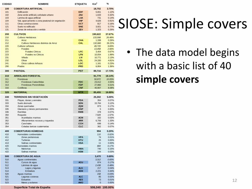
SIOSE: Simple covers
• The data model begins with a basic list of 40 simple covers
CODIGO ETIQUETA Km2 %
100 COBERTURA ARTIFICIAL 18,702 3.70%
101 Edificación EDF 5,651 1.12%
102 Zona verde artificial y arbolado urbano ZAU 1,633 0.32%
103 Lamina de agua artificial LAA 731 0.14%
104 Vial, aparcamiento o zona peatonal sin vegetación VAP 4,626 0.91%
111 Otras construcciones OCT 817 0.16%
121 Suelo no edificado SNE 3,921 0.77%
131 Zonas de extracción o vertido ZEV 1,323 0.26%
200 CULTIVOS 190,622 37.67%
210 Cultivos Herbáceos 133,998 26.48%
211 Arroz CHA 1,338 0.26%
212 Cultivos Herbáceos distintos de Arroz CHL 132,660 26.22%
220 Cultivos Leñosos 49,720 9.83%
221 Frutales 13,458 2.66%
222 Frutales Cítricos LFC 3,404 0.67%
223 Frutales no Cítricos LFN 10,054 1.99%
231 Viñedo LVI 10,771 2.13%
232 Olivar LOL 24,330 4.81%
241 Otros cultivos leñosos LOC 1,161 0.23%
290 Prados PRD 6,904 1.36%
300 PASTIZAL PST 89,716 17.73%
310 ARBOLADO FORESTAL 91,779 18.14%
311 Frondosas 50,872 10.05%
312 Frondosas Caducifolias FDC 23,012 4.55%
313 Frondosas Perennifolias FDP 27,860 5.51%
316 Coníferas CNF 40,907 8.08%
320 MATORRAL MTR 85,455 16.89%
330 TERRENOS SIN VEGETACIÓN 25,302 5.00%
331 Playas, dunas y arenales PDA 354 0.07%
333 Suelo desnudo SDN 15,764 3.12%
334 Zonas quemadas ZQM 873 0.17%
335 Glaciares y nieves permanentes GNP 5 0.00%
336 Ramblas RMB 378 0.07%
350 Roquedo 7,928 1.57%
351 Acantilados marinos ACM 162 0.03%
352 Afloramientos rocosos y roquedos ARR 6,706 1.33%
353 Canchales CCH 698 0.14%
354 Coladas lavicas cuaternarias CLC 362 0.07%
400 COBERTURAS HÚMEDAS 994 0.20%
410 Humedales continentales 110 0.02%
411 Zonas pantanosas HPA 74 0.01%
412 Turberas HTU 25 0.00%
413 Salinas continentales HSA 11 0.00%
420 Humedales marinos 884 0.17%
421 Marismas HMA 740 0.15%
422 Salinas marinas HSM 144 0.03%
500 COBERTURA DE AGUA 3,470 0.69%
510 Aguas continentales 3,312 0.65%
511 Cursos de agua ACU 874 0.17%
512 Láminas de agua 2,438 0.48%
513 Lagos y lagunas ALG 217 0.04%
514 Embalses AEM 2,221 0.44%
520 Aguas marinas 158 0.03%
521 Lagunas costeras ALC 85 0.02%
522 Estuarios AES 73 0.01%
523 Mares y océanos AMO 0 0.00%
Superficie Total de España 506,040 100.00%
NOMBRE
12

SIOSE: Composite covers
• Simple covers are aggregated into composite covers to describe fully the composition and structure of a polygon.
• Each simple cover is assigned its share of the surface of the polygon.
• Complex covers can be nested.
• A set of consistency rules are build into the database.
13

SIOSE: Composite covers
• Some composite covers are predefined, and have a particular structure.
• This is not an exhaustive list and can be adapted to particular needs.
CODIGO ETIQUETA Km2 %
701 DEHESA DHS 24,373 58.97%
702 OLIVAR VIÑEDO OVD 247 0.60%
703 ASENTAMIENTO AGRÍCOLA RESIDENCIAL AAR 1,765 4.27%
704 HUERTA FAMILIAR UER 393 0.95%
800 ARTIFICIAL COMPUESTO 14,556 35.22%
810 Urbano mixto 6,323 15.30%
811 Casco UCS 1,629 3.94%
812 Ensanche UEN 2,643 6.39%
813 Discontinuo UDS 2,051 4.96%
820 Industrial 1,799 4.35%
821 Polígono industrial ordenado IPO 949 2.30%
822 Polígono industrial sin ordenar IPS 330 0.80%
823 Industria aislada IAS 520 1.26%
830 Primario 1,617 3.91%
831 Agrícola/Ganadero PAG 727 1.76%
832 Forestal PFT 22 0.05%
833 Minero extractivo PMX 859 2.08%
834 Piscifactoría PPS 9 0.02%
840 Terciario 266 0.64%
841 Comercial y oficinas TCO 144 0.35%
842 Complejo hotelero TCH 51 0.12%
843 Parque recreativo TPR 27 0.07%
844 Camping TCG 44 0.11%
850 Equipamiento/Dotacional 1,238 3.00%
851 Administrativo institucional EAI 128 0.31%
852 Sanitario ESN 43 0.10%
853 Cementerio ECM 54 0.13%
854 Educación EDU 174 0.42%
855 Penitenciario EPN 11 0.03%
856 Religioso ERG 37 0.09%
857 Cultural ECL 47 0.11%
858 Deportivo EDP 280 0.68%
859 Campo de golf ECG 230 0.56%
860 Parque urbano EPU 234 0.57%
870 Infraestructuras 3,313 8.02%
880 Transporte 2,815 6.81%
881 Red viaria NRV 2,256 5.46%
882 Red ferroviaria NRF 337 0.82%
883 Portuario NPO 68 0.16%
884 Aeroportuario NAP 154 0.37%
890 Energía 137 0.33%
891 Eólica NEO 69 0.17%
892 Solar NSL 7 0.02%
893 Nuclear NCL 8 0.02%
894 Eléctrica NEL 21 0.05%
895 Térmica NTM 18 0.04%
896 Hidroeléctrica NHD 7 0.02%
897 Gaseoducto/Oleoducto NGO 7 0.02%
900 Telecomunicaciones NTC 5 0.01%
910 Suministro de agua 280 0.68%
911 Depuradoras y potabilizadoras NDP 35 0.08%
913 Desalinizadoras NDS 242 0.59%
912 Conducciones y canales NCC 3 0.01%
920 Residuos 76 0.18%
921 Vertederos y escombreras NVE 63 0.15%
922 Plantas de tratamiento NPT 13 0.03%
Superficie Total 41,334 100.00%
NOMBRE
14
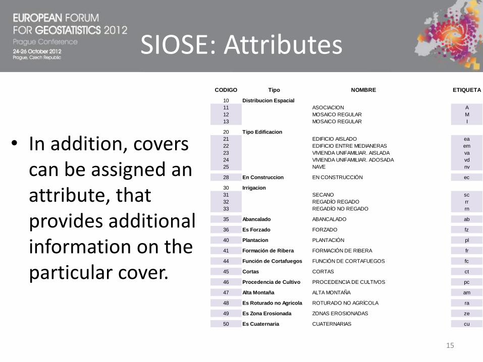
SIOSE: Attributes
• In addition, covers can be assigned an attribute, that provides additional information on the particular cover.
CODIGO ETIQUETA
10 Distribucion Espacial
11 ASOCIACION A
12 MOSAICO REGULAR M
13 MOSAICO REGULAR I
20 Tipo Edificacion
21 EDIFICIO AISLADO ea
22 EDIFICIO ENTRE MEDIANERAS em
23 VIVIENDA UNIFAMILIAR. AISLADA va
24 VIVIENDA UNIFAMILIAR. ADOSADA vd
25 NAVE nv
28 En Construccion EN CONSTRUCCIÓN ec
30 Irrigacion
31 SECANO sc
32 REGADÍO REGADO rr
33 REGADÍO NO REGADO rn
35 Abancalado ABANCALADO ab
36 Es Forzado FORZADO fz
40 Plantacion PLANTACIÓN pl
41 Formación de Ribera FORMACIÓN DE RIBERA fr
44 Función de Cortafuegos FUNCIÓN DE CORTAFUEGOS fc
45 Cortas CORTAS ct
46 Procedencia de Cultivo PROCEDENCIA DE CULTIVOS pc
47 Alta Montaña ALTA MONTAÑA am
48 Es Roturado no Agricola ROTURADO NO AGRÍCOLA ra
49 Es Zona Erosionada ZONAS EROSIONADAS ze
50 Es Cuaternaria CUATERNARIAS cu
Tipo NOMBRE
15

• Each polygon has a code label.
1. Polygon with a simple cover:
2. Polygon with a composite cover:
3. Polygon with a composite predefined cover:
4. Polygon with a nested composite cover:
SIOSE: Polygon labels
16

Example 1: Artificial area
Source: Guillermo Villa. IGN. EIONET OODMWG Meeting. Madrid 10-11 December 200917
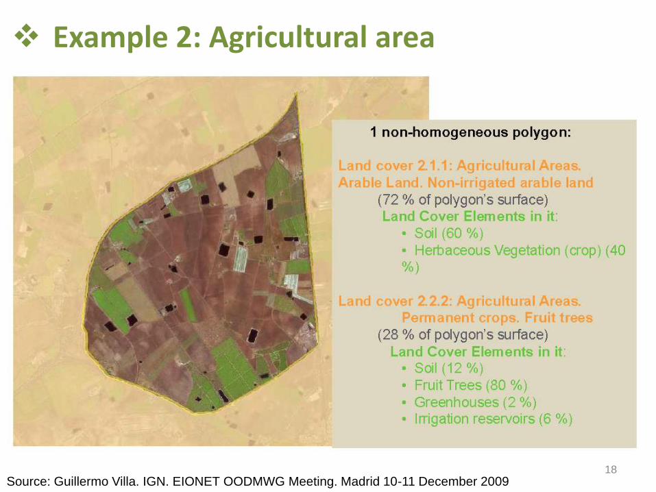
Example 2: Agricultural area
Source: Guillermo Villa. IGN. EIONET OODMWG Meeting. Madrid 10-11 December 200918

Example 3: Natural area
Source: Guillermo Villa. IGN. EIONET OODMWG Meeting. Madrid 10-11 December 200919

A nomenclature for SIOSE
• The power of SIOSE is also its weakness.
• For creating UMZ we need rules to determine the land cover classes to be considered as “urban areas”, so they can be included in the UMZ.
• Step 1: Create a nomenclature (hierarchical model) from SIOSE. Similar to CLC, but much more detailed: SIOSE´s Hierarchical Model (SHM).
• We devised an automatic algorithm that classifies each SIOSE polygon into a given set of classes, and all polygons are classified. 20

SHM classes(level 3)
• At level 4 SHM has 83 classes and at level 3 (comparable with CLC) it has 49 classes.
1. SUPERFICIES ARTIFICIALES1.1.
1.1.1. Tejido urbano continuo: casco
1.1.2. Tejido urbano discontinuo.
1.2.1.2.1. Actividad primaria.
1.2.2. Actividad industrial: polígonos, industrias aisladas
1.2.3. Servicios: comercial, oficinas, complejos hoteleros
1.2.4. Equipamiento diverso/Dotacional
1.2.5 Equipamiento deportivo/recreativo/cultural
1.3.1.3.1. Transporte
1.3.2. Energía
1.3.3. Telecomunicaciones
1.3.4. Suministro de agua
1.3.5. Residuos, vertederos y escombreras
1.4. En construcción1.4.1 Zonas urbanas
1.4.2. Estructuras de tipo público o industrial
1.4.3. Infraestructuras en construcción
2. ZONAS AGRÍCOLAS2.1.
2.1.1. Tierras de labor en secano
2.1.2. Terrenos regados permanentemente
2.1.3. Arrozales
2.2.2.2.1. Frutales cítricos
2.2.2. Frutales no cítricos
2.2.3. Olivares.
2.2.4. Viñedos.
2.2.5. Otros cultivos leñosos
2.3. Prados y praderas2.3.1. Prados y praderas
2.4.2.4.1. Asociación de cultivos anuales con permanentes
2.4.2. Mosaico de cultivos anuales/permanentes/pastos
2.4.3. Terrenos agrícolas con vegetación natural
2.4.4. Sistemas agroforestales (dehesas).
3.
3.1.3.1.1. Bosques de frondosas.
3.1.2. Bosques de coníferas.
3.1.3. Bosque mixto
3.2.3.2.1. Pastizales naturales.
3.2.2. Matorrales.
3.3. Espacios abiertos con poca o sin vegetación3.3.1. Playas, dunas y arenales.
3.3.2. Suelo desnudo
3.3.3. Zonas quemadas
3.3.4. Glaciares y nieves permanentes
3.3.5. Ramblas
3.3.6. Roquedo
Cultivos permanentes
Zonas agrícolas heterogéneas
ZONAS FORESTALES CON VEGETACIÓN NATURAL
Y ESPACIOS ABIERTOSBosques
Espacios de vegetación arbustiva y/o herbácea
Zonas urbanas
Zonas de actividad.
Infraestructuras
Tierras de labor
4. ZONAS HÚMEDAS4.1. Zonas húmedas continentales
4.1.1. Humedales y zonas pantanosas
4.1.2. Turberas y prados turbosos
4.1.3. Salinas continentales?
4.2. Zonas húmedas litorales4.2.1. Marismas
4.2.2. Salinas marinas
5. SUPERFICIES DE AGUA5.1.
5.1.1. Cursos de agua.
5.1.2. Láminas de agua.
5.2. Aguas marinas5.2.1. Lagunas costeras
5.2.2. Estuarios
5.2.3. Mares y océanos
Aguas continentales
21

A nomenclature for SIOSE
• The algorithm implements the following steps:
1. Create a correspondence table between SIOSE covers and the new SHM nomenclature.
2. Simplify SIOSE´s label into a “plain code” (simple/predefined composite cover and its associated share of surface, no nesting!)
3. Define assignment rules: majority and hierarchical simple rules and preference composite rules for polygons without a clear dominance structure. 22

A nomenclature for SIOSE• Assignment rules does not alter
SIOSE´s original polygons, so we can track the original information on each polygon.
SHM Code: 1314 - Airports
SIOSE´s ID_POLYGON: b382aa93-d59a-4a5d-bb81-3ebdaca6c5a6
SIOSE´s Label: NAP(70VAP_10EDFnv_10OCT_10SNE)
SIOSE´s dominant cover: 100NAP
SIOSE´s plain code: NAP 23

A nomenclature for SIOSE
• These rules mimics the technical information (photointerpretation manual) in developing CLC and SIOSE and are designed to minimize “heterogeneous covers”.
• A validation exercise against CLC gave more satisfactory results for our nomenclature (SHM) than for the nomenclature implemented in the Web Map Service (WMS) of IGN (IberPix).
24

UMZ
• Step 2: Given SHM create UMZ following a modified EEA´s methodology.
1. Core classes (CC): Urban fabric, Industrial and commercial units and Green urban areas.
2. Enlarged core classes (ECC): Port areas, Airports and Sport and leisure facilities if they are close (proximity rule) or neighbours (contiguity rule) to the CC. Iterative process.
3. Gaps: Forest, scrub, natural grassland, water treatment and desalination plants, dumps,… when they are completely within ECC.
25

UMZ
4. Linear features (LF): Road and rail networks and Water courses if they are neighbours (contiguity rule) to the ECC, then clipped by a 100m buffer.
5. Contiguity core classes: Go back to look for additional contiguity core classes not previously included. Iterative process.
6. Merge: Polygons lying less than 200m apart are merged under a unique identifier.
26

UMZ
• Eventually, UMZs less than a minimum threshold (20 ha) are dropped.
• In this way we generate about 5.000 UMZ.
• We work in vector format, the original geometry of polygons is not altered and we always keep the contents of each UMZ in terms of its composition: SHM polygons and the original SIOSE information.
• This implies than we can always recover the shares of simple SIOSE land covers for each UMZ.
• After population has been assigned a minimum threshold of population will be established.
27

UMZ: BarcelonaSIOSE polygons: 4,538
Area: 377.55 Km²
Population: 3,802,184
28

UMZ: BarcelonaSIOSE polygons: 4,538
Area: 377.55 Km²
Population: 3,802,184
29

Population
• Step 3: The UMZ vector layer is overlaid with a population grid, so a population figure is assigned to each UMZ.
• We used a top-down grid build from census tracks (ED) population data and SIOSE as auxiliary information.
30

Population
31

Population
• We are in the process of disaggregating population characteristics; like sex, age or nationality, but this information has not yet been exploited.
32

Urban Population
• We find 735 UMZ of at least 5,000 inhabitants that accounts for 35,348,163 inhabitants. Very similar to the population living in Urban Clusters (35,579,555), using Eurostat definition.
• We find 415 UMZ of at least 10.000 inhabitants and 101 UMZ of at least 50.000 inhabitants, that accounts for 26,702,656 inhabitants. A bit higher that the population living in Urban Centers (22,258,510), using Eurostat definition.
• We find 56 UMZ of at least 100.000 inhabitants and 3 UMZ with more than a million of population.
33

UMZ and LAU2
• Intersecting UMZ with LAU2 boundaries we can relate urbanization to political boundaries.
• 22 UMZ spread over more than 10 LAU2, but most of the UMZ (4,339) are confined within the limits of only one LAU2.
The UMZ from Barcelona is the more dispersed across municipal boundaries. It is present in 67 LAU2.
34

28.7%
18.6%
1.3%
22.6%
5.7%
17.7%
5.0%
0.5%
UMZ Madrid: Share of simple covers (SIOSE)
Buildings
Artificial Green Areas
Artificial Water Bodies
Streets and Artificial Surface Areas
Other Constructions
Non-Built Soil
Dump
Open Areas
UMZ: Madrid
35
Area: 605.90 Km²
Population: 4,833,124

47.3%
11.6%0.5%
21.2%
4.9%
11.9%
0.1%2.4%
UMZ Valencia: Share of simple covers (SIOSE)
Buildings
Artificial Green Areas
Artificial Water Bodies
Streets and Artificial Surface Areas
Other Constructions
Non-Built Soil
Dump
Open Areas
UMZ: Valencia
36
Area: 180.02 Km²
Population: 1,515,755
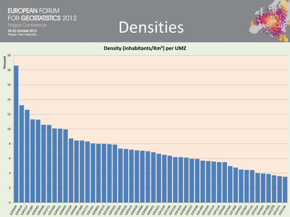
Densities
0
5
10
15
20
25
30
35
40
Tho
usa
nd
Density (inhabitants/Km²) per Urban Class
0
2
4
6
8
10
12
14
16
18
20
Tho
usa
nd
Density (inhabitants/Km²) per UMZ
37

Urban Indicators
0
500
1,000
1,500
2,000
2,500
Green Areas (m²) per person
38

Urban Indicators
0
20
40
60
80
100
120
Sports, leisure and cultural facilities (m² - class 125) per person
39
Urban Morphological Zones for Spain: Urban indicators from and Object Oriented Land
Cover data base and a population grid
Many thanks for your attention
Francisco J. Goerlich, University of Valencia and Ivie
Isidro Cantarino, Polytechnic University of Valencia
40