urban design study for the new central harbourfront · for the new central harbourfront” (the...
TRANSCRIPT

Urban Design Study for the New Central Harbourfront
PRELIMINARY SUSTAINABILITY ASSESSMENT REPORT
(March 2008)
Versitech (Technology Transfer) Ltd., HKU
Sustainability Assessment Report for the Urban Design Study for the New Central Harbourfront

Preliminary Sustainability Assessment Table of Contents 1. INTRODUCTION 1.1 Background………………………………………………………………… 1 1.2 Sustainable Design Principles……………………………………………… 2 1.3 Sustainable Design Criteria and Indicators………………………………… 3 1.4 Refined Urban Design Framework………………………………………… 4 2. OBJECTIVE 2.1 Approach of the PSA………………………………………………………. 6 2.2 Limitations…………………………………………………………………. 6 2.3 Report Structure……………………………………………………………. 6 3. EVALUATION AGAINST SUSTAINABLE DESIGN PRINCIPLES AND INDICATORS 3.1 Diverse Uses and Activities………………………………………………... 7 3.2 Respecting Natural and Urban Context……………………...…………….. 10 3.3 Promoting Harbourfront Enhancement…………………………………...... 12 3.4 Respecting Cultural Heritage……….……………………………………… 14 3.5 Ease of Pedestrian Access to Harbourfront..………………………………. 15 3.6 Promoting Environmentally Friendly Building Design and Greening……...18 4. CASET ASSESSMENT 4.1 Assumptions Made………………………………………………………… 19 4.2 Selection of Indicators……………………………………………………... 19 4.3 Other Major Considerations: Non-quantifiable issues……………………... 37 5. SUSTAINABILITY PERFORMANCE 38 6. CONCLUSION 39 7. RECOMMENDATION 40 REFERENCES 41
Sustainability Assessment Report for the Urban Design Study for the New Central Harbourfront

Sustainability Assessment Report for the Urban Design Study for the New Central Harbourfront
List of Tables Table 1 Summary of Major Differences between the Existing Scenario and the New Scenario with Scheme A & B Table 2 CASET Indicators Relevant to the Present Study Table 3 CASET Indicators Not Relevant to the Present Study Table 4 Calculation of the Estimation of Construction Waste Table 5 Calculation of Energy Use for Existing Urban Design Framework Table 6 Calculation of Energy Use for Refined Urban Design (Scheme A) Table 7 Calculation of Energy Use for Refined Urban Design (Scheme B) Table 8 Calculation of Construction Waste Requiring Landfill Table 9 Summary of the Proposed Leisure & Cultural Facilities Table 10 CASET Ball Diagram – Summary of Assessment Results List of Figure Figure 1 Location of Key Sites Figure 2 Refined Urban Design Framework Plan Figure 3 Master Layout Plan A Figure 4 Master Layout Plan B APPENDICES Appendix 1 Sustainable design principles and criteria presented at the Stage 1 Public Engagement of the Study launched in May 2007 Appendix 2 Guiding Principles Appendix 3 Sustainability Indicator List Appendix 4 List of All Social Checklist Questions Appendix 5 Summary of Proposed Development Schedule

Sustainability Assessment Report for the Urban Design Study for the New Central Harbourfront
-1-
Preliminary Sustainability Assessment for the Urban Design Study for the New Central Harbourfront Prepared by Versitech (Technology Transfer) Ltd. HKU
1. INTRODUCTION 1.1 Background
As requested by the Town Planning Board, the Planning Department has commissioned a consultancy study entitled “Urban Design Study for the New Central Harbourfront” (the Study) in March 2007 to refine the existing urban design framework for the New Central Harbourfront (NCH) and to prepare planning/ design briefs for the key sites in the study area (Figure 1). As part of the Study, the study consultant is required to formulate objectives and performance indicators for achieving a sustainable urban design for the study area and for assessing the performance of the refined urban design framework by carrying out a sustainability assessment (SA). Based on academic research on sustainable urban forms, the guidelines of Sustainable Development Unit (SDU), the Urban Design Guidelines of the Hong Kong Planning Standards and Guidelines, the Harbour Planning Principles and Guidelines of the Harbour-front Enhancement Committee, and the approved Central District (Extension) Outline Zoning Plan (OZP) No. S/H24/6 and Central District OZP No. S/H4/12 covering the NCH, the study consultant has developed a set of preliminary sustainable design principles and criteria which constitute a sustainable design framework for achieving sustainable urban design for the NCH. The public has been consulted on such preliminary sustainable design principles and criteria (Appendix 1) at the Stage 1 Public Engagement of the Study launched in May 2007.

Sustainability Assessment Report for the Urban Design Study for the New Central Harbourfront
-2-
1.2 Sustainable Design Principles Taking into consideration the findings on the sustainable design framework during the Stage 1 Public Engagement, a sustainable design assessment framework based on the following principles is adopted for designing the proposed refined urban design framework for the NCH. (a) Diverse Uses and Activities It has to provide a viable threshold to generate interactions to make urban functions or activities possible by allowing a diversity of activities, recreation, and building densities while responding to the social, cultural and economic context of the city. (b) Respecting Natural and Existing Urban Context The design needs to take into account the natural context including the harbour, the coastline, the ridgelines, and local climate. It is equally important to respond to and enhance the existing urban fabric of the area by ensuring continuity and connectivity. (c) Promoting Harbourfront Enhancement The Victoria Harbour is an important asset to our city, both in terms of image and as a functional harbour. Urban design along the harbourfront should provide opportunity for enhancement both in terms of image and functions. (d) Respecting Cultural Heritage History and culture are important issues for achieving sustainability, especially for the social aspects. The community concerns for preserving cultural heritage would need to be taken care of while providing opportunity for enhancement. (e) Ease of Pedestrian Access to Harbourfront Comprehensive pedestrian and vehicular traffic network should allow for walking and efficient public transport; encouraging social interaction and enabling accessibility to facilities and services at the NCH.

Sustainability Assessment Report for the Urban Design Study for the New Central Harbourfront
-3-
(f) Promoting Environmentally Friendly Building Design and Greening The building design in the NCH should embrace nature and be environmentally friendly. Landscaping should be encouraged where appropriate to improve the built environment and provide an amenable urban space.
1.3 Sustainable Design Criteria and Indicators
Under each sustainable design principle, a set of criteria with respect to the social, environmental and economic sustainability aspects were presented at the Stage 1 Public Engagement for public consultation. Generally speaking, the public has assigned greater importance to the social and environmental criteria as compared to the economic ones. The social, environmental and economic sustainable design criteria which were considered most important at the Stage 1 Public Engagement are as follows: (a) Social Aspects
- Ensuring public enjoyment of the harbour - Conserving the natural and cultural heritage - Enhancing cultural vibrancy and leisure opportunities
(b) Environmental Aspects - Harmonizing developments with the natural setting - Maintaining breezeways, view corridors and air ventilation corridors - Improving connectivity to public transport to reduce vehicular traffic - Better pedestrian environment - Minimizing environmental pollution - Improving urban climate and visual amenity - Enhancing openness and greenery
(c) Economic Aspects - Enhancing the image and functions of Victoria Harbour - Enhancing the identity of the city - Maintaining a spectacular skyline and harbour views - Providing opportunities for small-scale water-related business uses - Enhancing the functioning of CBD by improved connectivity and
ease of access

Sustainability Assessment Report for the Urban Design Study for the New Central Harbourfront
-4-
The findings of the Stage 1 Public Engagement on the sustainable design principles and criteria are used to formulate objectives and indicators for assessing the performance of the refined urban design framework for the NCH in terms of its sustainability implications.
1.4 Refined Urban Design Framework
Taking into consideration the findings on the sustainable design framework and other public views received during the Stage 1 Public Engagement, the study consultant has developed a refined urban design framework for the NCH. The refined urban design framework (Figure 2) is envisaged to bring a vibrant, green and accessible NCH. Key features identified in the refined urban design framework include the following:
(a) four principal design corridors (i.e. Statue Square Corridor,
Civic Corridor, Pierside Corridor, and Arts and Cultural Precinct) and the Waterfront Promenade; each of which with distinctive character precincts, landmarks, anchoring public spaces, etc;
(b) a diversity of uses comprising commercial, retail, recreational and tourism activities to promote a vibrant waterfront;
(c) a comprehensive open space and landscape strategy; (d) more diversified urban design emphasis covering building
heights, form and massing, and preservation of views to the ridgeline and to the harbour;
(e) a comprehensive multi-level pedestrian network plan; and (f) cultural heritage considerations for the re-assembly of
Queen’s Pier and the reconstruction of the old Star Ferry Clock Tower and preservation of other historical sites.
In addition, two master layout plans (Figures 3 and 4) have been developed for the study area based on the proposed refined urban design framework with variations in the design concepts for key sites. The
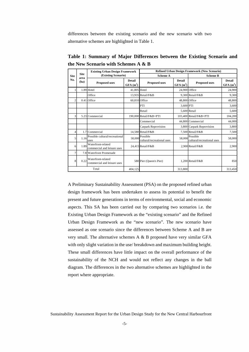
differences between the existing scenario and the new scenario with two alternative schemes are highlighted in Table 1. Table 1: Summary of Major Differences between the Existing Scenario and
the New Scenario with Schemes A & B
Proposed usesDetail
GFA (m2)Proposed uses
Detail GFA (m2)
Proposed usesDetail
GFA (m2)
1 1.89 Hotel 41,805 Hotel 24,900 Office 24,900
Office 13,935 Retail/F&B 9,300 Retail/F&B 9,300
2 0.41 Office 60,810 Office 48,800 Office 48,800
PTI 3,600 PTI 3,600
Retail 5,600 Retail 5,600
3 5.23 Commercial 190,000 Retail/F&B+PTI 103,400 Retail/F&B+PTI 104,200
Commercial 44,800 Commercial 44,000
Carpark Reprovision 3,800 Carpark Reprovision 3,800
4 1.7 Commercial 14,580 Retail/F&B 7,500 Retail/F&B 7,500
5 1.16 Possible cultural/recreational uses 58,000 Possible
cultural/recreational uses 58,000 Possible cultural/recreational uses 58,000
6 1.89 Waterfront-related commercial and leisure uses 24,415 Retail/F&B 2,900 Retail/F&B 2,900
7 7.8 Waterfront Promenade
8 0.22 Waterfront-related commercial and leisure uses 580 Pier (Queen's Pier) 1,200 Retail/F&B 850
404,125 313,800 313,450
Site No.
Scheme B
Total
Scheme ARefined Urban Design Framework (New Scenario)Existing Urban Design Framework
(Existing Scenario)Site area (ha)
A Preliminary Sustainability Assessment (PSA) on the proposed refined urban design framework has been undertaken to assess its potential to benefit the present and future generations in terms of environmental, social and economic aspects. This SA has been carried out by comparing two scenarios i.e. the Existing Urban Design Framework as the “existing scenario” and the Refined Urban Design Framework as the “new scenario”. The new scenario have assessed as one scenario since the differences between Scheme A and B are very small. The alternative schemes A & B proposed have very similar GFA with only slight variation in the use/ breakdown and maximum building height. These small differences have little impact on the overall performance of the sustainability of the NCH and would not reflect any changes in the ball diagram. The differences in the two alternative schemes are highlighted in the report where appropriate.
Sustainability Assessment Report for the Urban Design Study for the New Central Harbourfront
-5-

Sustainability Assessment Report for the Urban Design Study for the New Central Harbourfront
-6-
2. OBJECTIVE
2.1 Approach of the PSA This report sets out the sustainability implications of the proposed refined urban design framework as compared to the baseline scenario (i.e. the existing urban design framework) based on the PSA. Computer Aided Sustainability Evaluation Tool (CASET) developed under the Study on Sustainable Development in Hong Kong for the 21st Century (SUSDEV21) will also be used to evaluate the sustainability performance of the proposal. The CASET aims to assist Government in evaluating new strategic initiatives or major programmes from a sustainable development perspective. The sustainability assessment helps to scope out cross-sectional issues affecting the sustainability impact of the proposal. Reference
to the 8 guiding principles set out by the SDU (Appendix 2) has been made in carrying out this report. The refined urban design framework and the various design schemes and concepts will be put forward for public consultation at the Stage 2 Public Engagement for the Study scheduled for commencement in April 2008. Taking into consideration the public views received, the proposed refined urban design framework will be further revised and a further SA will be carried out for the Study before finalizing the study proposals and recommendations.
2.2 Limitations Assessments of any impact are quantified as far as possible. However, since the study is based on the urban design framework rather than detailed design, detailed information on specifics such as cost and return are not available at this stage.
2.3 Report Structure Following this Chapter, Chapter 3 will evaluate the performance of the refined urban design framework against the sustainable design principles and indicators, with respect to the social, environmental and economic aspects. Chapter 4 will outline the use of the CASET and present the performance of the refined urban design framework under each of the relevant sustainability indicators under the CASET.

Sustainability Assessment Report for the Urban Design Study for the New Central Harbourfront
-7-
Chapter 5 will provide a summary of the sustainability performance of the existing scenario (existing urban design framework) and the new scenario (refined urban design framework) at a territorial level in the form of the CASET ball diagram. Chapter 6 will provide a conclusion for the PSA and Chapter 7 will provide recommendations for further action.
3 EVALUATION AGAINST SUSTAINABLE DESIGN PRINCIPLES AND INDICATORS
The proposed refined urban design framework is evaluated against the sustainable design principles and criteria under the social, environmental and economic aspects derived from the Stage 1 Public Engagement of the Study.
3.1 Diverse Uses and Activities
3.1.1 Social Aspects 3.1.1.1 Enhancing cultural vibrancy and leisure opportunities
The waterfront promenade provides a large open space with activity nodes and key attraction points are planned to provide opportunities for different leisure activities. Cultural attractions are proposed for the NCH, particularly in the Arts and Cultural Precinct with exhibition gallery and public art installations. An outdoor performance area is proposed as an extension of the surrounding arts and cultural activities, namely the Hong Kong Convention and Exhibition Centre, the Hong Kong Academy for Performing Arts, and the Hong Kong Academy for Performing Arts Extension, the Hong Kong Arts Centre and the proposed Hong Kong Visual Arts Education Centre. The outdoor performance area also provides opportunities for other more passive leisure activities when there is no performance.

Sustainability Assessment Report for the Urban Design Study for the New Central Harbourfront
-8-
3.1.1.2 Diversity of activities serving different sectors of the community A hierarchy of interlinked public open spaces for more passive activities such as harbour viewing and strolling is proposed to serve different sectors of the community. The proposed open space areas include, inter alia:
- Waterfront Event Plaza - Ferry Plaza - Featured Plaza - Pier Walk - Harbour Walk - Bayside Walk - Urban Mound, flat lawn/ undulating lawn - Statue Square Corridor More active activities are catered for by proposing recreational facilities such as public landing steps to allow water-related activities (e.g. fishing, sampan loading/unloading and possible swim races); fountain, water-play area and floating market. Other possible activities include dining (alfresco and indoor), retail activities (from open air market stalls to underground commercial and retail), tourism related activities (hotel and souvenir booths), and commercial activities (office spaces).
3.1.2 Environmental Aspects 3.1.2.1 Compatible land uses and marine facilities
NCH development accommodates a compatible mix of land uses based on the approved Central District (Extension) OZP No. S/H24/6 and the approved Central District OZP No. S/H4/12, including commercial, open spaces, waterfront-related commercial and leisure uses, and GIC uses. The refined urban design framework would promote a harmonious juxtaposition of the different uses with the harbourfront and marine facilities such as ferry piers. Linkages between land uses and marine uses will be provided to maintain the continuity of land and marine uses.

Sustainability Assessment Report for the Urban Design Study for the New Central Harbourfront
-9-
3.1.2.2 Harmonizing utility buildings and infrastructure with harbourfront setting
In order to provide visual enjoyment to the public, the NCH should harmonize the design of utility building and the infrastructure with the harbourfront setting. To this end, the refined urban design framework would minimize the visual impact of infrastructure buildings such as pump-houses and electricity supply building through appropriate landscaping design.
3.1.3 Economic Aspects 3.1.3.1 Creating business and job opportunities
NCH development will accommodate a significant amount of commercial/ business opportunities creating a significant number of new jobs. These business opportunities may be emerged in various forms: through provision of commercial spaces (office, retail, hotels etc), and other leisure facilities. About 10,000 employment opportunities are anticipated to be generated from the NCH. Planned commercial developments, retail and office complexes are expected to generate around 64% of total employment in the NCH development. Planned cultural and recreational facilities are also important in creating new employment opportunities. In addition to the employment generation, a significant amount of investment in infrastructure and building construction is expected in the refined urban design framework, which would enhance the economic competitiveness of Hong Kong in the future. The refined urban design framework, with a diversity of uses comprising commercial, retail, recreational and tourism activities to promote a vibrant harbourfront, will further enhance economic activities in Hong Kong.
3.1.3.2 Meeting economic needs NCH will improve the unemployment situation to a certain extent which will improve income level of people. It is expected some upward change in income and benefits for lower quartile of income groups. In the refined urban design framework, it is expected to generate a significant

Sustainability Assessment Report for the Urban Design Study for the New Central Harbourfront
-10-
number of new jobs (part-time as well as full time) for lower quartile section, in the service and retail sector. The middle and upper class sections will also be benefited from the NCH development. Middle class job opportunities emerge as administrative staff and related to those commercial and offices. Upper income class mainly derives some benefits from having ownership and operations of commercial shops, restaurants and related activities.
3.2 Respecting Natural and Urban Context 3.2.1 Social Aspects 3.2.1.1 Conserving natural heritage of the city
Natural heritage is an important asset for a city. The Hong Kong Island has a natural setting overlooking the Victoria Harbour and a mountain backdrop. The refined urban design framework respects the dominance of Victoria Peak and Victoria Harbour by means of adopting appropriate forms and massing of buildings. Building mass of appropriate height, disposition and orientation is articulated to allow permeability for visual connection, openings and voids are positioned between and within buildings to frame waterfront views as well as views towards the ridgelines and the harbour.
3.2.1.2 Enhancing legibility of the urban fabric The refined urban design framework is planned to harmonize with adjoining developments and enhancing the legibility of the urban fabric. Important view corridors are protected and the disposition and alignment of buildings conform to the broader urban fabric, maintaining a high level of visual permeability and the introduction of new urban nodes for better legibility. The scale, height and disposition of adjoining developments are taken into consideration and conflict is mitigated. It is envisaged that the new developments will co-exist in visual harmony with the existing urban fabric and all developments will complement each other. Considerations have also been given to preserving and enhancing the view corridors of the major landmark buildings within or in close proximity to the study area

Sustainability Assessment Report for the Urban Design Study for the New Central Harbourfront
-11-
3.2.2 Environmental Aspects 3.2.2.1 Maintaining breezeways, view corridors and air ventilation corridors
In order to preserve views to ridgelines and mountain backdrops, a 20% to 30% building free zone is to be maintained as recommended by the Urban Design Guidelines. Visual analysis has been conducted for the refined urban design framework to ensure the proposed new buildings in the NCH comply with these guidelines. Diversity in building mass and varying building heights along the Harbourfront are provided to promote a skyline with visual interest and enhance the dynamic image of the harbour. Building height restrictions have been applied with consideration to the scales and heights of the nearby existing developments. Proposed developments bordering the harbourfront in Site 1 and Site 8 comply with the maximum building heights set out in the existing urban design framework. This will maintain openness to the waterfront and a step-down effect of height profile from the ridgeline. Sites near to the harbour which span across the Harbourfront, including Sites 4 and 6, would be occupied by buildings of small footprints to avoid creating an impermeable “wall” along the harbourfront and hindering air ventilation. The commercial developments on Site 1 and Site 2 is confined to 18 storeys in Scheme A and 16 storeys in Scheme B and 30 storeys respectively with due consideration to their proximity to the harboufront, the massing forms are designed to enhance its visual and physical permeability.
The disposition of buildings, open space, public realm and pedestrian network is arranged to allow view corridors to preserve views to and from the harbour, the ridgelines, major landmark buildings and buildings free zones. A degree of visual permeability is achieved through ground level “transparency”, well-defined entrances and integration of visual landmarks. Building lines would also help to define and direct view corridors. A series of open space corridors and linked open spaces are adhered to in order to achieve north-south view lines for a more permeable waterfront.

Sustainability Assessment Report for the Urban Design Study for the New Central Harbourfront
-12-
The visual softening is proposed to mitigate any interference to these visual corridors. These are highlighted by the use of screening by soft works such as tree alignments and structures. The ground level finishes are used to enhance visual interest to open spaces.
3.2.3 Economic Aspects 3.2.3.1 Improving image and identity of CBD and Hong Kong
The refined urban design framework for the NCH, which is envisaged to be vibrant, green and accessible, would enhance the image and identity of the CBD. A quality urban environment for business and financial activities can be achieved through enhancing image and functions of the city, which would be needed for further investment attractions for future generations to benefit. The spectacular skyline and harbour view are maintained to serve as a symbol of Hong Kong.
3.3 Promoting Harbourfront Enhancement 3.3.1 Social Aspects 3.3.1.1 Public enjoyment and appreciation of the Harbour
Both active and passive appreciation of the Harbour has been planned in the refined urban design framework. Active appreciation is anticipated along the Bayside Walk extending along towards the Wan Chai side of the Harbourfront. An outdoor performance area is proposed to be used as an extension to the Hong Kong Arts Centre, the Hong Kong Academy of Performing Arts and the Hong Kong Academy of Performing Arts Extension for further cultural and recreational uses. Passive appreciation is planned along the Pier Walk which is adjacent to the piers. Landscaping design, scenery framing and street furniture have been proposed to enhance the experience for pedestrian traveling to and from the ferry piers.
3.3.2 Environmental Aspects 3.3.2.1 High quality environment
The waterfront promenade provides a large of area open space with greenery for the public to enjoy harbour appreciation and various activities. Various activity nodes and key attraction points are planned

Sustainability Assessment Report for the Urban Design Study for the New Central Harbourfront
-13-
along the promenade to animate the vicinity and to create a dynamic waterfront for the Hong Kong people, workers in the CBD as well as tourists.
3.3.3 Economic Aspects 3.3.3.1 Opportunities for small scale waterfront-related business uses
The refined urban design framework in the NCH development accommodates a significant amount of waterfront related small-scale business activities. The proposed waterfront promenade and other leisure facilities in the development are expected to enhance the attractiveness to locals and visitors. Though the NCH does not directly aim at tourism industry, development/improvement of ferry piers, leisure hub centres and hotels/retail/entertainment centres would definitely boost the tourism industry. It is anticipated to accommodate leisure and entertainment developments with variety of tourist-oriented activities, including open-air market stalls, alfresco dining and teahouses. These activities will create variety of small-scale business activities.
3.3.3.2 Enhancing image and functions of Victoria Harbour
The refined urban design framework, with a diversity of uses comprising commercial, retail, recreational and tourism activities to promote a vibrant waterfront, would enhance the image and functions of the Victoria Harbour in various ways. The proposed waterfront promenade would provide a unifying spine for the harbourfront. Vibrant and diverse activities are proposed along the walk for public enjoyment, with large nodal attraction areas provided. Character zones are proposed in connection with the surrounding existing and planned developments. Proposals to enhance its visual permeability and harmonize with the existing environment would further promote the city as a tourist destination.
Sustainability Assessment Report for the Urban Design Study for the New Central Harbourfront
-14-
3.4 Respecting Cultural Heritage
3.4.1 Social Aspects 3.4.1.1 Conserving cultural heritage of the harbourfront
Cultural heritage is an integral feature in a city and helps towards improving social sustainability since historical link and collective memory enhances a sense of belonging to the community. Queen’s Pier, a Grade 1 historical building, will be re-assembled and the Old Star Ferry Clock Tower will be reconstructed. Historical sites within the study area, such as the Statue Square, Edinburgh Place and City Hall are preserved. Some proposed anchoring spaces are planned as follows: • Exhibition Gallery Various spaces is proposed to be created for accommodating periodical exhibitions and events, where different interest groups and individuals within the community can display and share artwork, information, skills and other objects of general interest to the public. • Public Art Installations Public art installations can contribute to a more aesthetically pleasing landscape environment and to increase the community’s cultural awareness. • Pier Walk Viewing Decks Upper-level viewing decks are planned between the piers for unobstructed view of the Victoria Harbour. It is destined to be a tourist attraction for tourists en route to boarding the ferries.
3.4.2 Environmental Aspects 3.4.2.1 Enhancing the setting for sites of cultural heritage value and interest
The spatial, contextual and historical relationship among cultural heritage such as the City Hall, the reconstructed old Star Ferry Clock Tower, reassembled Queen’s Pier, Edinburgh Place and the harbour will

Sustainability Assessment Report for the Urban Design Study for the New Central Harbourfront
-15-
be maintained, enhanced, expanded and further explored with flexibility to harmonize with the NCH. A new ‘Statue Square Corridor’ is proposed to be developed as a continuous landscaped pedestrian deck with a Historical Corridor that runs alongside, connecting the historical sites within the NCH. The tree-lined boulevard and proposed landscape strategy would enhance the setting for sites of cultural heritage value and interest, creating a compatible environmental setting for the public enjoyment and appreciation for these sites.
3.4.3 Economic Aspects 3.4.3.1 Business opportunities related to arts, culture and local heritage
The refined urban design framework is enriched with four principal design corridors (Statue Square Corridor, Civic Corridor, Pier side Corridor and Arts and Culture Precinct) and the waterfront promenade. It is anticipated that business opportunities related to variety of arts, leisure and entertainment activities along with variety of tourist-oriented activities would be created, including open-air market stalls, alfresco dining and teahouses. Providing an attractive, healthy and functional place to visit with improved services, opportunities related to arts, culture and local heritage; improving transportation system, environment and aesthetic image of the city are important to keep the city as an economically attractive place.
3.5 Ease of Pedestrian Access to Harbourfront
3.5.1 Social Aspects 3.5.1.1 Ease of movement between hinterland and harbourfront
Accessibility between the harbourfront and the hinterland is enhanced by the proposed multi-level pedestrian network. Accessibility to other areas of the city is enhanced by relieving the current traffic congestion in Central with the enhanced road network and expanded MTR network.

Sustainability Assessment Report for the Urban Design Study for the New Central Harbourfront
-16-
3.5.1.2 Provision of different modes of access and choices The Statue Square Corridor provides the main north-south pedestrian connection and the key public transport nodes are planned along the corridor. The different modes of transport include: - Bus/ Public light bus - MTR - Taxi/ Coach - Private vehicles - Star Ferry and ferry services to outlying islands - At-grade pedestrian walkways - Elevated pedestrian walkways - Underground pedestrian walkways - Vertical Connections Direct and continuous access to the area via public transport is facilitated by careful planning of the pedestrian network.
3.5.2 Environmental Aspects 3.5.2.1 Improving connectivity to public transport to reduce vehicular traffic
In order to facilitate more efficient and convenient east-west connection along the promenade, environmental-friendly and pedestrian-friendly public system has been proposed in the approved OZP no S/H24/6. The refined urban design framework has made reserve for environmentally friendly trolley car system at the waterfront promenade. The system provides an alternative for pedestrians to access from Wan Chai to Central or vice versa, other than walking or taking other vehicles which may cause traffic congestion in the vicinity. To make it a major tourist attraction in the area, regular stops are proposed at the following key activity nodes along the promenade: - The ferry plaza in front of the Central Ferry Piers No. 9 & 10 - The waterfront event plaza in front of the Civic Square of government office complex (the Tamar Site) - Landscaped plaza at the Arts and Cultural Precinct near Marine Place (Site 6) and the HKCEC

Sustainability Assessment Report for the Urban Design Study for the New Central Harbourfront
-17-
3.5.2.2 Better pedestrian environment
As a unifying green edge to the Victoria Harbour and the CBD, the promenade provides an opportunity to enhance the east-west pedestrian connection in the area, which is quite weak nowadays. With a vibrant harbourfront in a landscape setting, the public and tourist would be attracted to access between Central and Wanchai via the promenade. The promenade will also attract the public to approach the waterfront from inner Central via the enhanced pedestrian network in the area. The improved north-south pedestrian connection will encourage the use of ferry services and alleviate other means of cross-harbour traffic.
3.5.3 Economic Aspects 3.5.3.1 Enhancing functioning of CBD by improved connectivity
Proposals with regard to connectivity and ease of access in the refined urban design framework are expected to enhance function of the CBD further. It is expected to generate indirect economic impacts through improved connectivity and ease of access. It is anticipated to generate indirect economic impacts by improving transport network (overall accessibility) due to the CWB and Road P2 which will alleviate traffic allowing speedier and more efficient transport which in turn improves the travel speed. Major traffic problems in the Central area which would directly affect road based public transport reliability and attractiveness will be improved through the CWB. This will assist public transport by reducing at grade traffic demand, enabling public transport services to operate to their designated timetable. Such reliability is essential to ensure that passengers continue to use the services. Through efficient and sensitive transport-land use planning, the refined urban design framework is expected to contribute to the sustainability guiding principle of promoting a safe, accessible and efficient transport network of Hong Kong.

Sustainability Assessment Report for the Urban Design Study for the New Central Harbourfront
-18-
3.6 Promoting Environmentally Friendly Building Design and Greening 3.6.1 Social Aspects 3.6.1.1 Better urban environment in which to visit, work and enjoy
The extensive open space and urban parks planned for the NCH with significant vegetation would provide a pleasant green environment for all. It is well established that vegetation has positive effect on both physical and mental health. One of the urban design objectives for the NCH is to create a harmonious visual and physical relationship with the ridgeline, harbour setting and CBD which would provide an ideal setting for the general public, tourists and the working population in the area. Reduced development density, carefully controlled building height and building mass as proposed in the refined urban design framework would also facilitate better air ventilation in the NCH.
3.6.2 Environmental Aspects 3.6.2.1 Improving urban climate, visual amenity and compatibility with natural
setting One of the benefits of using greening such as green roof in the building is to reduce the heat gains to the building interior. Therefore it will reduce the amount of energy needed to cool the building. The use of greening will reduce the urban heat island effect and improve the urban climate. Landscaping or greening will also improve visual amenities.
3.6.2.2 Enhancing openness and greenery The promenade provides an extensive green open space linking with the existing open spaces in the surrounding areas, and creates a pleasant environment for the public to enjoy and relax in the CBD.
3.6.2.3 Minimizing environmental pollution and energy uses The provision of extensive landscape and the green roof in NCH will reduce the amount of CO2 emission. Biologically, plant consumes CO2 by its bio-function of photosynthesis. Therefore it could serve as an approach to sequestrate CO2 and reduce green house gas emission.

Sustainability Assessment Report for the Urban Design Study for the New Central Harbourfront
-19-
3.6.3 Economic Aspects 3.6.3.1 Quality urban environment for the business and financial district
A quality urban environment for business and financial activities can be achieved through enhancing image and functions of the city. Proposed developments in the NCH would aim at providing such a quality urban environment with environmentally friendly building design and greenery. In an attempt to create a more vibrant atmosphere, in the refined urban design framework, buildings with a mix of hotel, commercial, culture, recreational and other social oriented activities are proposed. This will attract more foreign investments to the city.
4. CASET ASSESSMENT
4.1 Assumptions made (a) Population will increase up to 7.2 million by 2010 and 7.8 million by 2020. (b) GDP growth rate per annum is assumed to be 6% from 2007 to 2010. (c) The Government will maintain its current policy on expenditure on public works/services. (d) The sustainability assessment for the engineering and road works for Wan Chai Development Phase II (WDII) has been taken into account.
4.2 Selection of Indicators
The indicators used to assess the proposal are generated by answering the Screening and Characterization Questions in the CASET. After responding to the prescribed questions in the CASET system, and editing the list of indicators manually, 18 out of 26 indicators were confirmed as ‘affected indicators’ under the Economy, Natural Resources, Environmental Quality and Mobility Indicator List. Six aspects of the social checklist were also considered as affected and were taken into account in the assessment. The full CASET Report is submitted under separate cover. The full list of the sustainability
indicators (Appendix 3) and the list of all social checklist questions (Appendix 4) are attached for reference. The 18 indicators and the 6 aspects of the social checklist considered relevant (“affected”) are shown in Table 2.

Sustainability Assessment Report for the Urban Design Study for the New Central Harbourfront
-20-
Table 2: CASET Indicators Relevant to the Present Study Guiding Principles Indicator Indicator Description
Cost Benefit
Economic return as determined through cost benefit analysis
Fixed Capital Gross domestic fixed capital formation as a ratio to GDP
Freight costs The cost of road-based freight transport; the cost of charges and operating costs as a ratio to GDP
Income differential Difference between percentage change in the upper quartile of after-tax household income and percentage change in the lower quartile of after-tax household income
Economy
Unemployment rate Unemployment rate Construction Waste Quantity of construction waste
requiring final disposal per capita
Energy Consumption Consumption of energy per unit of output ($GDP)
Freshwater supplied and consumed
Volume of freshwater supplied per capita
Municipal waste Quantity of municipal solid waste requiring final disposal per capita
Landfill capacity The total remaining landfill capacity (by volume)
Significant landscape features (Area based)
Area of significant landscape features
Natural Resources
Significant landscape features (Point based)
Total number of point-based significant landscape features and old and valuable trees
Carbon dioxide emitted per year
Quantity (Tonnes) of carbon dioxide emitted per year
Criteria air pollutants Composite index for Criteria Air Pollutants based on percentage of Air Quality Objectives
Excessive Noise Percentage of population exposed to excessive noise
Environmental Quality
Toxic air pollutants Composite index for toxic air pollutants based on percentage

Sustainability Assessment Report for the Urban Design Study for the New Central Harbourfront
-21-
Guiding Principles Indicator Indicator Description of acceptable risk
Marine water quality Composite index for marine water quality pollutants based on percentage of the Water Quality Objectives
Mobility Travel speed Average network speed; calculated as total passenger kilometers divided by total passenger hours
Social Checklist
Equal opportunity Opportunities of the elderly, children, youth, women and low income group to participate in society and to fully develop themselves and not to be discriminated because of health, gender, financial or other constraints
Society and social infrastructure
Social cohesion People’s (including youth’s) sense of belonging to society and/ or their involvement in the community (including voluntary work) as well as social cohesion, mutual support and networking
Health and Hygiene Physical and mental health Effects on the physical and/ or mental health of the community (such as an increase or a decrease in communicable diseases, cancer and respiratory diseases due to change in air pollutant level)
Leisure and cultural facilities
Effects on the level of provision, quality and/ or variety of sports, recreational or cultural facilities
Leisure and cultural activities`
Effects on people’s participation in sports, recreational or cultural activities
Leisure and Cultural Vibrancy
Archaeological/ historical sites
Effects on any archaeological site or buildings of cultural heritage

Sustainability Assessment Report for the Urban Design Study for the New Central Harbourfront
-22-
The indicators which were not generated by the prescribed ‘Characterization questions or manually removed were considered to be irrelevant to the proposal under assessment. These “unaffected indicators” under the guiding principles and social checklist, together with the reasons for their removal from the assessment are shown in Table 3.
Table 3: CASET Indicators Not Relevant to the Present Study Guiding Principles
Indicator Indicator Description Reason for Removal
Economy Travel Distance Average travel distances: the distance in kilometers traveled by passengers during morning peak by all major groups of transport modes
Better pedestrian linkages are proposed in the refined urban design framework, however, the travel distance during morning peak by transportation will not be affected
Natural Resources
Local Freshwater
Percentage of demand met by locally-derived freshwater resources
No proposal of any locally derived freshwater resources such as reservoir
Managed marine habitat
Area of managed marine habitat for conservation
Area not in proximity to managed marine habitat for conservation
Managed terrestrial habitat
Area of managed terrestrial habitat for conservation
Area not in proximity to managed terrestrial habitat for conservation
Marine eco-value
Area of Hong Kong of high marine ecological value
No area of high marine ecological value in proximity to the NCH
Biodiversity
Terrestrial eco-value
Area of Hong Kong of high terrestrial ecological value
No area of high terrestrial ecological value in proximity to the NCH
Leisure and cultural vibrancy
Open Space Shortfall
Percentage of population living within districts with a shortfall of required provision of open space
NCH does not fall within district with shortfall of required provision of open space.*
Environmental Quality
River water quality
Percentage of EPD’s river monitoring stations ranked “excellent” or “good” using EPD’s River Water Quality Index
No river in NCH

Sustainability Assessment Report for the Urban Design Study for the New Central Harbourfront
-23-
Social Checklist
Safety Net Effects on the safety net (in terms of social welfare and housing) for the disadvantaged groups such as the elderly, the infirm, the unemployed, the disabled and families with single parent
No significant relevance
Self-reliance Effects on the will and ability of the disadvantaged, the poor and the unemployed to achieve self-reliance
No significant relevance
Society and social infrastructure
Family solidarity Effects on family relationship and resilience, as well as family functioning
No significant relevance
Health and Hygiene
Health of vulnerable groups
Potentially adverse health effects likely to be disproportionately greater for the vulnerable groups in the community
No particular health risks
Housing waiting time
Effects on the waiting time for public rental housing
No housing provision proposed in the NCH
Private rent Effects on the rental level in the private housing market
No significant relevance
Living Space Effects on the average living space per person
No significant relevance
Housing
Adequate housing
Effects on the number of people residing in inadequate housing
No housing provision proposed in the NCH
Education Attainment
Education attainment
Effects on the access of people of working age to post-secondary education or above
No significant relevance
Note*According to Hong Kong Planning Standards and Guidelines (HKPSG), in the urban
areas, the standard for provision of open space is a minimum of 20 ha per 100,000 persons
i.e. 2m2 per person. The provision of open space in the NCH is higher than the HKPSG
requirements. Although not assessed under the CASET, the sustainability impact (social,
environmental and economic) of open space provision in the NCH is discussed in Chapter 3
The impacts are also reflected in the assessment under “Physical/mental Health”, “Leisure
and cultural facilities” and “Leisure and cultural activities in the CASET Social Checklist.

Sustainability Assessment Report for the Urban Design Study for the New Central Harbourfront
-24-
4.2.1 Economy 4.2.1.1 Cost-benefit
The refined urban design framework proposes to reduce total GFA significantly compared to the existing urban design framework
(Appendix 5). Proper CB analysis however is not possible at this stage due to unavailability of some detailed data as the study is still at a conceptual design stage. The indicator on the economic return is expected to increase. NCH development will bring a significant amount of commercial/ business opportunities creating a significant number of new jobs. These economic benefits may be emerged in various forms: through provision of commercial spaces (office, hotel and retail), and other commercial and leisure facilities. Besides, the proposed low-rise cultural and leisure uses with variety of tourist-oriented activities along the harbourfront will also attract tourists and hence benefit the tourism sector. The proposed waterfront promenade and other leisure facilities in the development are expected to enhance the attractiveness to locals and visitors. Development of ferry piers, leisure hub centres and hotels/retail/entertainment centres would help boost the tourism industry.
4.2.1.2 Fixed capital A significant amount of investment in infrastructure and building construction is expected in the NCH, which would enhance the economic competitiveness of Hong Kong in the long term. Proposed broader investment in infrastructure facilities and other developments such as office/commercial, hotel, leisure facilities and open space etc would improve the urban environment and enhance the image of the city. These facilities will enhance economic competitiveness of the city in the long term. With a reduction of GFA in the refined urban design framework, relatively a considerable amount of fixed capital investment is expected to decrease. However, substantial analysis is not possible at this stage due to unavailability of detailed data as the study is still at a conceptual design stage.

Sustainability Assessment Report for the Urban Design Study for the New Central Harbourfront
-25-
4.2.1.3 Freight costs A considerable transport costs reduction is expected through traffic improvement (due to the availability of CWB and Road P2 which will alleviate traffic allowing speedier and more efficient delivery to CBD). Through efficient and sensitive transport-land use planning, the NCH is expected to contribute to the sustainability guiding principle of promoting a safe, accessible and efficient transport network of Hong Kong.
4.2.1.4 Income differential Around 10,000 employment opportunities are to be generated from the NCH. It is thus expected some upward change in income and benefits for lower quartile of income groups. The refined urban design framework is expected to generate relatively a larger number of new jobs (part-time as well as full time) for lower quartile section. The middle and upper class sections will also be benefited from the NCH development. Middle class number of job opportunities emerges as administrative staff and related to those commercial and offices. Upper income class mainly derives some benefits from having ownership and operations of business, commercial shops, restaurants and related activities.
4.2.1.5 Unemployment rate
The refined urban design framework will bring around 10,000 new employment opportunities, which will help improve the unemployment rate to a certain extent. These jobs will mainly be emerged through commercial (office, retail, hotels etc), cultural and other leisure facilities. Besides, there may be some small-scale employment related to water-front and tourist related small-scale business activities. It is anticipated to create some small-scale jobs from leisure and entertainment developments with variety of tourist-oriented activities, including open-air market stalls, alfresco dining and teahouses. The proposed waterfront promenade and other leisure facilities in the development are expected to enhance the attractiveness to locals and visitors.

Sustainability Assessment Report for the Urban Design Study for the New Central Harbourfront
-26-
4.2.2 Natural Resources 4.2.2.1 Construction Waste
Construction waste is expected to increase with the extensive works associated with the proposed developments in NCH. The extent of change, however, is expected to be small due to the small quantum of developments in NCH as compared with the territorial total. The construction waste will be re-used for public filling as far as possible to minimize that net amount of waste generated. There will be about 65,898 and 65,825 m3 construction waste for Scheme A and B respectively, compared to 84,866 m3 construction wasted produced by the existing Urban Design Framework. Detailed calculation presented in Table 4 below:
Table 4: Calculation of the Estimation of Construction Waste
No. Design Option GFA
(m2)
Construction
Waste
(m3/m2)*
Total
Construction
Waste (m3)
1 Existing Urban Design 404,125 0.21 84,866
2 Refined Urban Design (Scheme A) 313,800 0.21 65,898
3 Refined Urban Design (Scheme B) 313,450 0.21 65,825
Note:
* The construction waste standard is based on the study done by Poon et al. (2004)
Approximately 80% is inert that can be used for public filling such as site formation. Only about 20% will require landfill. Moreover, suitable measures such as environmental-friendly construction method will be adopted to further minimize waste during construction.
4.2.2.2 Energy Consumption The consumption of energy is expected to increase with the additional activities brought by new developments in NCH. However, if we compare the energy for the existing design with the refined urban design, there has been a reduction of operational energy use. It is broadly estimated that this project require about 1,141 million MJ/year and 1,128

million MJ/year for Scheme A and B, as compared to the baseline 1,392 million MJ/year. There is a reduction of 18.03% and 18.97% for the Scheme A and B, respectively in the operational phase. Detailed calculation can be found in Tables 5 - 7 below:
Table 5: Calculation of Energy Use for Existing Urban Design Framework
Site No.
Site area (ha)
GFA (Existing)
(m2)Proposed uses
Detail GFA (m2)
Energy Standard MJ/m2/ annum*
Energy Consumed MJ/annum
1 1.89 55,740 Hotel 41,805 1,575 65,842,875Office 13,935 1,132 15,774,420
2 0.41 60,810 Office 60,810 1,132 68,836,9203 5.23 190,000 Commercial 190,000 5,000 950,000,0004 1.7 14,580 Commercial 14,580 3,000 43,740,000
5 1.16 58,000 Possible cultural/recreational uses 58,000 3,000 174,000,000
6 1.89 24,415 Waterfront-related commercial and leisure uses 24,415 3,000 73,245,000
7 7.8 Waterfront Promenade 0
8 0.22 580 Waterfront-related commercial and leisure uses 580 1,000 580,000
404,125 1,392,019,2153,445
Note:
Total
Energy per unit floor (MJ/m2/annum)
* Energy Standard based on the EMSD energy indicators (energy consumed per unit floor area per annum) for different types of buildings
Sustainability Assessment Report for the Urban Design Study for the New Central Harbourfront
-27-

Table 6: Calculation of Energy Use for Refined Urban Design Framework (Scheme A)
Site No.
Site area (ha)
GFA (Existing)
(m2)Proposed uses
Detail GFA (m2)
Energy Standard MJ/m2/ annum*
Energy Consumed MJ/annum
1 1.89 34,200 Hotel 24,900 1,575 39,217,500Retail/F&B 9,300 5,000 46,500,000
2 0.41 58,000 Office 48,800 1,132 55,241,600PTI 3,600 500 1,800,000Retail 5,600 5,000 28,000,000
3 5.23 157,400 Retail/F&B+PTI 103,400 5,000 517,000,000Commercial 44,800 5,000 224,000,000Carpark Reprovision 3,800 500 1,900,000
4 1.7 7,500 Retail/F&B 7,500 5,000 37,500,000
5 1.16 5,800 Possible cultural/recreational uses 58,000 3,000 174,000,000
6 1.89 2,900 Retail/F&B 2,900 5,000 14,500,0007 7.88 0.22 1,200 Pier
0(Queen's Pier) 1,200 1,000 1,200,000
313,800 1,140,859,1003,636
Note:
TotalEnergy per unit floor (MJ/m2/annum)
* Energy Standard based on the EMSD energy indicators (energy consumed per unit floor area per annum) for different types of buildings Table 7: Calculation of Energy Use for Refined Urban Design Framework (Scheme B)
Site No.
Site area (ha)
GFA (Existing)
(m2)Proposed uses
Detail GFA (m2)
Energy Standard MJ/m2/ annum*
Energy Consumed MJ/annum
1 1.89 34,200 Office 24,900 1,132 28,186,800Retail/F&B 9,300 5,000 46,500,000
2 0.41 58,000 Office 48,800 1,100 53,680,000PTI 3,600 500 1,800,000Retail 5,600 5,000 28,000,000
3 5.23 157,400 Retail/F&B+PTI 104,200 5,000 521,000,000Commercial 44,000 5,000 220,000,000Carpark Reprovision 3,800 500 1,900,000
4 1.7 7,500 Retail/F&B 7,500 5,000 37,500,000
5 1.16 5,800 Possible cultural/recreational uses 58,000 3,000 174,000,000
6 1.89 2,900 Retail/F&B 2,900 5,000 14,500,0007 7.88 0.22 850 Retail/F&B 850 1,000 850,000
313,450 1,127,916,8003,598
Note:
TotalEnergy per unit floor (MJ/m2/annum)
* Energy Standard based on the EMSD energy indicators (energy consumed per unit floor area per annum) for different types of buildings
Sustainability Assessment Report for the Urban Design Study for the New Central Harbourfront
-28-
0

Sustainability Assessment Report for the Urban Design Study for the New Central Harbourfront
-29-
Energy efficient building design will be one of the solutions for this indicator. In addition to that we advise to generate some portion of renewable energy in the site, such as solar energy. It is also advised to propose energy efficient building design. If adopted, it is expected to contribute to the principle to promote the sustainable use of natural resources to minimize its ecological footprint through improving consumption (energy) efficiency. Environmental friendly transport system will also contribute to the reduction of energy use in the site.
4.2.2.3 Freshwater supplied and consumed It is estimated that the water consumption per capita for this area will be less than the baseline due to the building type. In accordance with the consumption statistics provided by Water Supplies Department (WSD), the fresh and salt water consumed in 2006 are 2.64 Mm3/day and 0.71 Mm3/day respectively. The increase in water consumption is considered small due to small quantum of developments in NCH as compared with the territorial total. For NCH developments, it is advised to include water-recycling and rain water collection for flushing and landscape purpose. By including these measures, the use of salt and fresh water provided by WSD could be reduced to a certain amount. Water-recycling could be applied by, for example, separate the plumbing and drainage system of grey and black water. The recycled water than can be used to flush the toilet. The rain-water collection can be installed in the roof of buildings and in the landscape area.
4.2.2.4 Municipal waste
Municipal waste is expected to increase with the development in NCH. The municipal waste will be generated from the offices, retail, hotel, and open spaces. However, from a territorial perspective, the increase in waste generation is not significant due to small quantum of developments in NCH. Waste management system will be considered in the NCH development. Waste management system including avoid, minimize and reduce/recycle waste by using measures such as education, waste charges, and product responsibility scheme (PRS). To implement this, suitable space should be provided in the NCH, such as at the building and the landscape area.

4.2.2.5 Landfill capacity This indicator is selected to examine the capacity of Hong Kong to manage its own waste in an environmentally safe and cost-effective manner. As development of NCH would only be increased by a rather insignificant volume of waste that require disposal at landfill, it will result in a small degree of deterioration to the current situation. This project will produce about 13,180 and 13,165 m3 non-inert construction waste for Scheme A and B, respectively. There will be a reduction of about 22% compared to for existing design (16,973 m3). These will require about 0.0145% of the landfill area (based on 2004 figure). Detailed calculation can be found in Table 8:
Table 8: Calculation of Construction waste requiring landfill
1 84,866 16,973
2 65,898 13,180
3 65,825 13,165Note:
No. Design OptionTotal
Construction Waste (m3)*
* The calculation based on the total construction w** The calculation of landfill required based on the EPD website that mention about 20% of construction waste
The requierd landfill (m3)**
Existing Urban Design
Refined Urban Design (Scheme A)
Refined Urban Design (Scheme B)
4.2.2.6 Significant landscape features (Area based) According to CASET, area based significant landscape features would engender positive aspects of landscape character. In NCH development the landscape features included in this indicator are the extensive open space (urban park). The open coastal water will also be maintained and no more reclamation of the Victoria Harbour in NCH area is expected. Overall speaking, this indicator is expected to be improved. It will contribute to the increase about 0.003% of the area of landscape in Hong Kong.
Sustainability Assessment Report for the Urban Design Study for the New Central Harbourfront
-30-

Sustainability Assessment Report for the Urban Design Study for the New Central Harbourfront
-31-
4.2.2.7 Significant landscape features (Point based) Point based significant landscape features includes landscape features of limited extent. It includes natural features as well as buildings, edifices, structures or built landscape features. It comprises declared/deemed monuments and graded buildings, landmark buildings, landmark structures, landmark hydrological features and landmark geological/physiographic features. Of the list of point based significant features defined under CASET, landmark features found in NCH ,include the re-assembled Queen’s Pier and the reconstructed Old Star Ferry Clock Tower. It will only increase about 0.08%. The extent of influence of NCH on natural resources is considered minimal due to small quantum of developments in NCH as compared with the territorial total. Nevertheless, provision of considerable amount of landscape area and preservation of significant features, re-assembling Queen’s Pier and reconstructing Old Star Ferry Clock Tower has made the development desirable.
4.2.3 Environmental Quality 4.2.3.1 Carbon dioxide emitted per year
It is expected that the CO2 emission will be decreased in NCH. This emission is mostly caused by transportation in the site. This includes ferry that docked at the piers, buses, trucks, taxis, cars and taxis that take and drop the passengers, buses at Central bus terminus, and also from vehicle parking from offices. Traffic congestions have very high impact on the CO2 emission due to the frequently start and stop of vehicles. The provision of Road P2 and CWB will reduce traffic congestions in this area. This will result in the reduction of CO2 emission associated with the vehicles. In addition to this, there are several measures that could reduce CO2 problem. This is including the provision of greening (landscaping) and restraining the provision of public carparking spaces and auxiliary carparking spaces as proposed in the refined urban design framework. The use of environmental-friendly system for moving people along the east-west promenade will also minimize the CO2 emission due to vehicles fuel combustion.

Sustainability Assessment Report for the Urban Design Study for the New Central Harbourfront
-32-
4.2.3.2 Criteria air pollutants The operation of ferries and vehicular flow to and from the developments will increase criteria air pollutants but there will be a very small denomination in this indicator and air pollutants protection measures will be applied,
4.2.3.3 Percentage of population exposed to excessive noise No residential blocks will be provided in the NCH. Noise prevention measures would be provided in the offices & hotels guestrooms. The provision of Road P2 and CWB will reduce traffic congestion in this area. This will result in the reduction of noise pollution associated with vehicles. The indicator is expected to decrease.
4.2.3.4 Composite index for toxic air pollutants The TAPs index consists of three main indicators i.e. Benzo(a)pyrene, Benzene and Formaldehyde. The baseline is derived from the average value between the average concentration of the three indicators recorded at the Tsuen Wan Station (TWS) and Central/Western Station (CWS). All figures recorded at CWS for three indicators were consistently lower than in TWS. The CWS TSPs index in 2004 was 29.9%. This is much lower than the baseline. The major contributor to the air pollutants in the NCH development is from vehicular traffic emission. Because of the provision of Road P2 and CWB, air pollutants index will be decreased. Therefore, it is expected that the air pollution index will be minimized and there is a very small decrease in this indicator.
4.2.3.5 Composite index for marine water quality
The marine water quality may deteriorate due to runoff waste water from landscaping (fertilizer, pesticides), runoff from vehicle waste (oil, rubber emissions residues) and runoff from street cleansing (detergents, ammonia). To avoid this problem, runoff from landscaping and vehicle waste should be directed to the drainage system before they discharge to the sea. In the drainage system filters and treatments should be applied to make sure that the discharged water will not harm the marine water quality. Other preventive measures can be used, such as reduce use of chemicals, self-cleaning surfaces, etc. In addition, the provision of

Sustainability Assessment Report for the Urban Design Study for the New Central Harbourfront
-33-
cooling water plumbing along the seashore should not be located near to the recreational area. There is a small decrease in this indicator.
4.2.4 Mobility 4.2.4.1 Travel speed
Travel speed is expected to be improved, especially with passenger travel speed, and also freight transport to a certain extent (movement of goods within Hong Kong is predominately road based). Transport network will be improved to a certain extent. According to the Wan Chai Development Phase II Planning and Engineering Review, it is predicted that without the CWB, the peak-hour traffic along the Eastern Corridor will increase by about 30% from 2004 to 2016, which will result in longer queue lengths and longer periods of traffic congestion. Without the CWB, traveling along the 4km corridor will take about 45 minutes at a speed of 5km/hr in 2011. The existing pedestrian walkways would also be improved due to the provision of a comprehensive pedestrian network, which would improve the travel speed of pedestrians from major transport interchange to specific destinations in the area.
4.2.5 Social Checklist 4.2.5.1 Equal opportunity
The proposal would improve the opportunities of such social groups as the elderly, children, youth, women and low income group to participate in society and not be discriminated since the access to the NCH would be barrier free and amenities such as the waterfront promenade, the urban parks or public open space will be open to all members of the public at no cost.
4.2.5.2 Social cohesion The implementation of NCH project would improve sense of belonging to society since the refined urban design framework aims for a vibrant and accessible harbourfront which is very much a symbol of Hong Kong. The reconstruction of the old Star ferry clock tower and reassembling of

Sustainability Assessment Report for the Urban Design Study for the New Central Harbourfront
-34-
Queen’s Pier within the NCH would also go towards bringing up collective memory and conservation of the cultural heritage.
4.2.5.3 Physical and mental health The extensive open space provided at the NCH including the waterfront promenade and increased accessibility to the harbourfront should be able to encourage the public to spend more time outdoors for physical activities which has potential to improve physical and mental health. Fresh air has the benefit of decreasing the risk of communicable diseases. The extensive urban parks or public open space would provide significant vegetation to help mitigate the negative environmental effects and comfort level of increased activities in the area.
4.2.5.4 Leisure and cultural facilities
The proposal will increase the level of provision, quality and variety of recreational and cultural facilities for the public. Proposed facilities include waterfront-related leisure, entertainment and commercial uses with alfresco dining areas, outdoor media shows and performance venues; an Arts and Cultural Precinct with galleries, outdoor art display and performance, alfresco dining and outdoor seating; a Civic Corridor extending from Tamar and comprising outdoor forums, amphitheatre and open spaces. A brief summary of the leisure and cultural facilities proposed within each Key Site is presented in the following table:
Table 9: Summary of the Proposed Leisure & Cultural Facilities Key Sites Leisure and Cultural Facilities Site 1 & 2 Retail, café and waterfront related uses
Site 3 Landscaped pedestrian deck, possible site for
reconstructing the old Star Ferry Clock Tower and gallery, at-grade open park, sunken plaza, water features
Site 4 Low-rise waterfront related commercial and leisure development with open-air market, alfresco dining and teahouses, possible site for reconstructing the old Star Ferry Clock Tower and gallery

Sustainability Assessment Report for the Urban Design Study for the New Central Harbourfront
-35-
Key Sites Leisure and Cultural Facilities Site 5 & 6 Arts & Cultural Precinct, HKAPA Extension, proposed
Visual Arts Education Centre , amphitheatre, sitting out areas, cafés and alfresco dining, waterfront promenade, public landing steps
Site 7 Waterfront promenade – Pier Walk, Harbour Walk and Bayside Walk
Site 8 Possible location for reassembling the Queen’s Pier to provide public landing steps, viewing and entrance decks for Central Piers no. 9 and 10
4.2.5.5 Leisure and cultural activities With the increased leisure and cultural facilities provision at the NCH and the accessibility by different types of transport, it can be anticipated that the people from all areas across the territory will be encouraged to make use of the provision and participate in recreational and cultural activities.
4.2.5.6 Historical sites
Under the CASET classification, only declared monuments recorded by the Antiquities and Monuments Office are considered. However, to respond to the public’s nostalgic feelings attached to the old Star Ferry Clock Tower, the components such as the clock faces, chimes and other mechanical parts have been retained and the Clock Tower will be re-constructed within the Study Area. To respect cultural heritage and respond also to the call for collective memories, the study proposals have allowed for reassembling of Queen’s Pier, which is a Grade 1 historical building. The Study also proposes historical link among the identified heritage features to enhance the opportunities for the enjoyment of the public and tourists.
Sustainability Assessment Report for the Urban Design Study for the New Central Harbourfront
-36-
4.2.6 First SD Strategy Checklist To ensure that the assessment of the proposal takes account of the latest developments in the territory’s sustainable strategy, a checklist of questions relating to the agreed targets and objectives of the three pilot areas, including solid waste management, renewable energy and urban living space, under the Government’s First Sustainable Development Strategy has to be answered. The refined urban design framework affects two of these three pilot areas (renewable energy and urban living space).
4.2.6.1 Solid Waste Management The refined urban design framework does not have significant impact on achieving the Government’s targets in solid waste management since there are no specific proposals for waste management within the NCH.
4.2.6.2 Renewable Energy The proposal will possibly affect the area of renewable energy by a small extent. Although the refined urban design framework does not include any specify proposal of renewable energy generation within the NCH, green features such as solar panels, wind turbines and other energy efficient and conservation technologies where appropriate are encouraged. Therefore, the proposal has the potential to help promote the supply and consumption of renewable energy as well as energy efficiency and conservation by acting as a showcase for future developments.
4.2.6.3 Urban Living Space The three targets for this area of sustainable strategy address issues of regeneration of older urban districts, further development of the New Territories and maintenance and review of sustainable urban planning and design guidelines, with special regard to issues such as buildings affecting view corridors or restricting air flow. The development of the NCH will affect the last target involving view corridors and air flow. As discussed in the previous sections, the refined urban design framework for the NCH has considered sustainable urban planning and design practices in terms of provision of quality open space,
Sustainability Assessment Report for the Urban Design Study for the New Central Harbourfront
-37-
environmental quality, air ventilation impact, visual quality and landscape impact. Air Ventilation Assessment has been carried out to analyze the impact on air ventilation. Quality open spaces have been proposed under a comprehension open space and landscape strategy. Preservation of views to the ridgeline and to the harbour ensures visual quality and improves streetscape. Social-cultural characteristics can be fostered with the provision of four principal design corridors and the waterfront promenade, each of which distinctive character precincts, landmarks and anchoring public spaces. Cultural heritage considerations have been given for the reassembly of Queen’s Pier and the reconstruction of the old Star Ferry Clock Tower as well as preservation of other historical sites.
4.3 Other Major Considerations: Non-quantifiable issues 4.3.1 Public opinions
Extensive public engagement activities for the Study will be conducted to collect public views such that the refined urban design framework would better meet the public aspirations. Stage 1 Public Engagement has completed and the findings have been taken into consideration in the study proposals for the Stage 2 Public Engagement.
4.3.2 Visual impact Visual corridors, careful massing and building height, as well as extensive public spaces provided would minimize any possible adverse visual impact. The view of the Victoria Harbour is enhanced and ridgeline of the Victoria Peak is preserved. The extensive open spaces proposed are expected to improve greening and improve the urban environment.
4.3.3 Urban design and landscape quality The NCH is an important asset for the city and its people. The important historical setting and existing urban fabric are enhanced with urban design and landscape features to improve their potential for public enjoyment. They would also help to exhibit the distinctive character of the NCH.
Sustainability Assessment Report for the Urban Design Study for the New Central Harbourfront
-38-
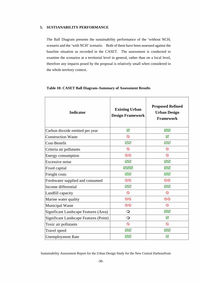
5. SUSTIANABILITY PERFORMANCE The Ball Diagram presents the sustainability performance of the ‘without NCH; scenario and the ‘with NCH’ scenario. Both of them have been assessed against the baseline situation as recorded in the CASET. The assessment is conducted to examine the scenarios at a territorial level in general, rather than on a local level, therefore any impacts posed by the proposal is relatively small when considered in the whole territory context.
Table 10: CASET Ball Diagram–Summary of Assessment Results
Indicator Existing Urban
Design Framework
Proposed Refined Urban Design Framework
Carbon dioxide emitted per year
Construction Waste
Cost-Benefit
Criteria air pollutants
Energy consumption
Excessive noise
Fixed capital
Freight costs
Freshwater supplied and consumed
Income differential
Landfill capacity
Marine water quality
Municipal Waste
Significant Landscape Features (Area)
Significant Landscape Features (Point)
Toxic air pollutants
Travel speed
Unemployment Rate

Sustainability Assessment Report for the Urban Design Study for the New Central Harbourfront
-39-
Social Checklist
Equal opportunity
Social cohesion
Physical/mental health
Leisure and cultural facilities
Leisure and cultural activities
Archaeological/historical sites
Legends Annotates no change to the current baseline situation
Very Small
Small ModerateModerate to
Large Large Very Large
Improvement
Deterioration
6. CONCLUSION
A preliminary sustainability assessment has been carried out for the proposed refined urban design framework, which is based on of the following sustainable design principles derived from the Stage 1 Public Engagement of the Study: * Diverse uses and activities; * Respecting the natural context and existing urban fabric; * Promoting harbourfront enhancement; * Respecting cultural heritage; * Ease of pedestrian access to harbourfront; and * Promoting environmentally friendly building design and greening. The preliminary sustainability assessment indicates that the refined urban design framework would bring about a range of benefits; particularly in the economic, social and mobility aspects, such as generating more business and employment opportunities, accommodating leisure, cultural and government facilities, creating a significant landscaped area and quality waterfront at the heart of the city, cultivating a sense of place, meeting the need for essential strategic transport infrastructure and facilitating the ease of movement.
Sustainability Assessment Report for the Urban Design Study for the New Central Harbourfront
-40-
While the proposals would have less desirable implications on the environmental and natural resources aspects compared to the status quo, such implications would be kept to the minimum with the incorporation of environmental mitigation measures as recommended in the approved EIA. Further sustainability assessment will be conducted after the Stage 2 Public Engagement in drawing up the recommendations, taking into account comments received in the public consultation.
7. RECOMMENDATION
This report is conducted based on the proposed refined urban design framework, the final and eventual implementation of sustainability measures of the New Central Harbourfront is subject to detailed architectural design. Preventive measures should be installed in the future developments in the NCH to minimize any negative impact. It is noted that planning/design briefs with clear design parameters and guidelines will be prepared for the key sites to guide future design and implementation. The preliminary sustainability assessment contributes towards the formulation of such planning/design briefs at a later stage of the Study.

Sustainability Assessment Report for the Urban Design Study for the New Central Harbourfront
-41-
REFERENCES
1. Poon, C.S., Yu, A.T.W., Wong, S.W., and Cheung, E., 2004, Management of construction waste in public housing projects in Hong Kong, Journal of Construction Management and Economics, vol. 22, no. 7, pp. 675-689(15).
2. EMSD, 2007, Energy consumption indicators and benchmarks: Indicators
http://www.emsd.gov.hk/emsd/eng/pee/ecib_indicators.shtml 3. EPD, 2007, Introduction to construction waste
http://www.epd.gov.hk/epd/misc/cdm/introduction.htm 4. Chapter 11, Urban Design Guidelines, Hong Kong Planning Standards and Guidelines
http://www.pland.gov.hk/tech_doc/hkpsg/english/ch11/ch11_text.htm 5. Harbour Planning Principles; Harbour-front Enhancement Committee (HEC)
http://www.harbourfront.org.hk/eng/content_page/doc/HPP_0503.pdf 6. Harbour Planning Guidelines for Victoria Harbour and its Harbour-front Areas;
Harbour-front Enhancement Committee (HEC) http://www.harbourfront.org.hk/eng/content_page/doc/HPG_draft.pdf
7. Approved Central District (Extension) Outline Zoning Plan (OZP) No. S/H24/6 and
Central District OZP No. S/H4/12
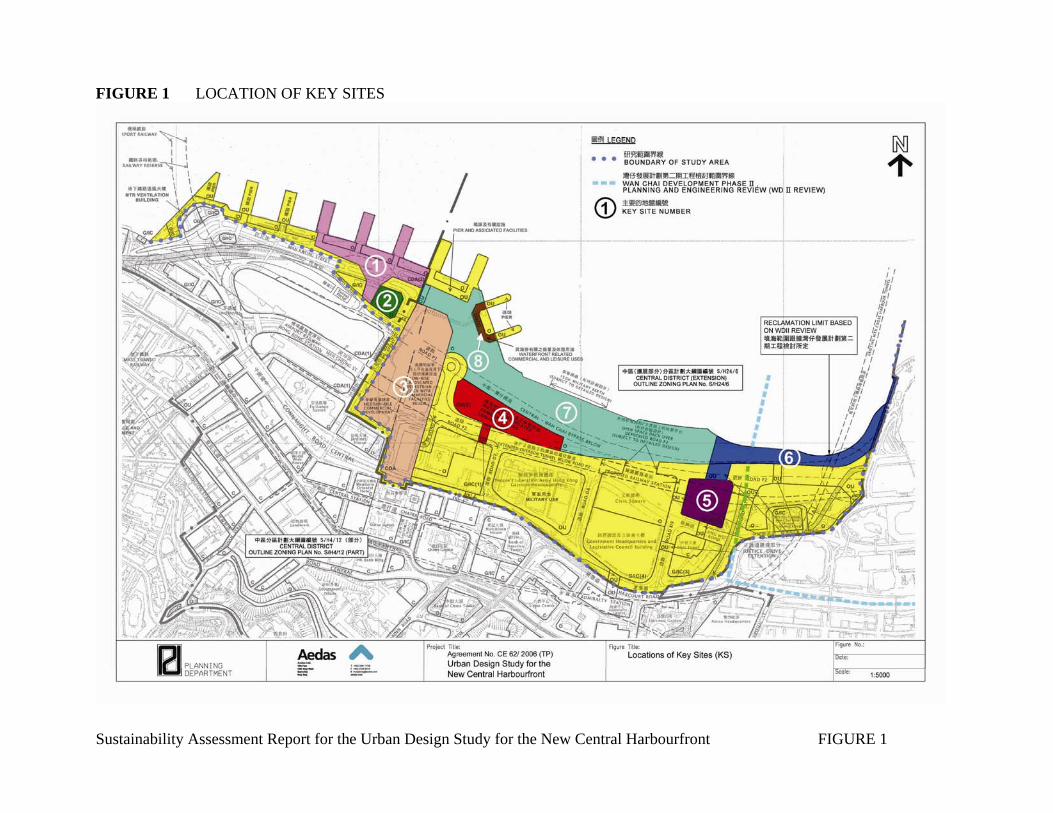
FIGURE 1 LOCATION OF KEY SITES
Sustainability Assessment Report for the Urban Design Study for the New Central Harbourfront FIGURE 1
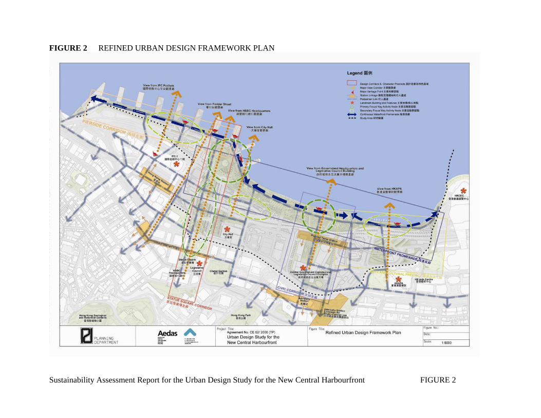
FIGURE 2 REFINED URBAN DESIGN FRAMEWORK PLAN
Sustainability Assessment Report for the Urban Design Study for the New Central Harbourfront FIGURE 2

FIGURE 3 MASTER LAYOUT PLAN A
Sustainability Assessment Report for the Urban Design Study for the New Central Harbourfront FIGURE 3

Sustainability Assessment Report for the Urban Design Study for the New Central Harbourfront FIGURE 4
FIGURE 4 MASTER LAYOUT PLAN B

APPENDIX 1
Sustainability Assessment Report for the Urban Design Study for the New Central Harbourfront
-i-
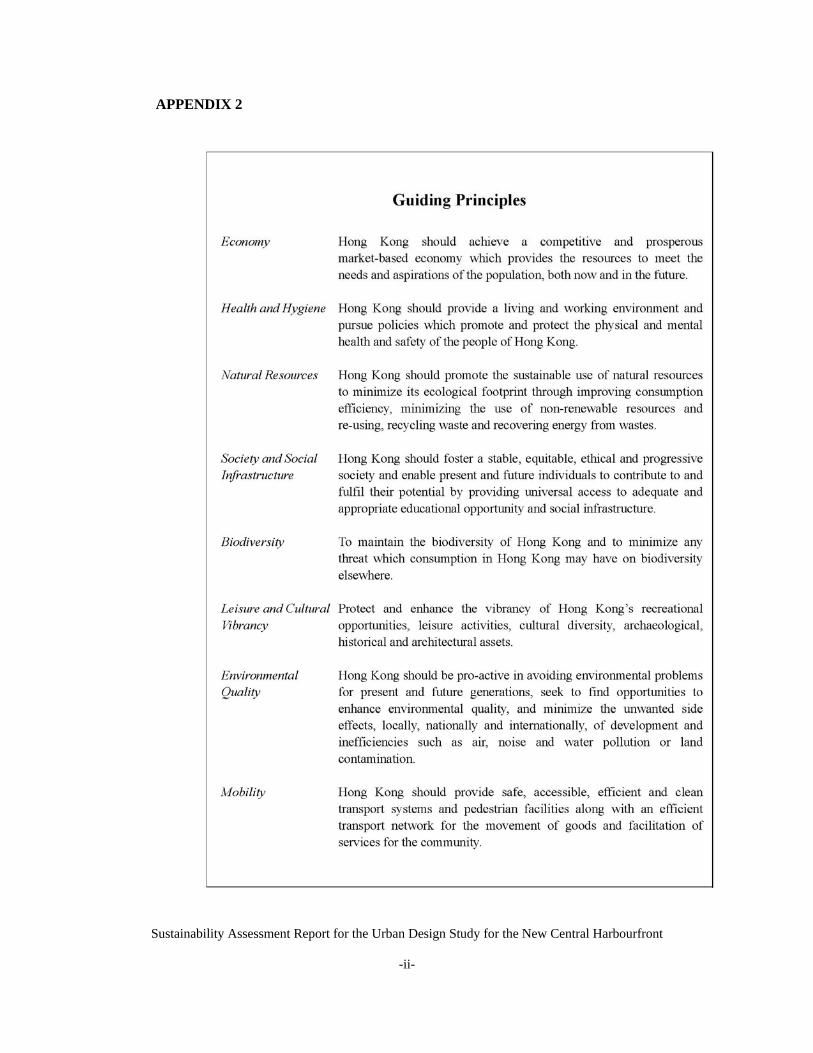
APPENDIX 2
Sustainability Assessment Report for the Urban Design Study for the New Central Harbourfront
-ii-

APPENDIX 3
Sustainability Assessment Report for the Urban Design Study for the New Central Harbourfront
-iii-
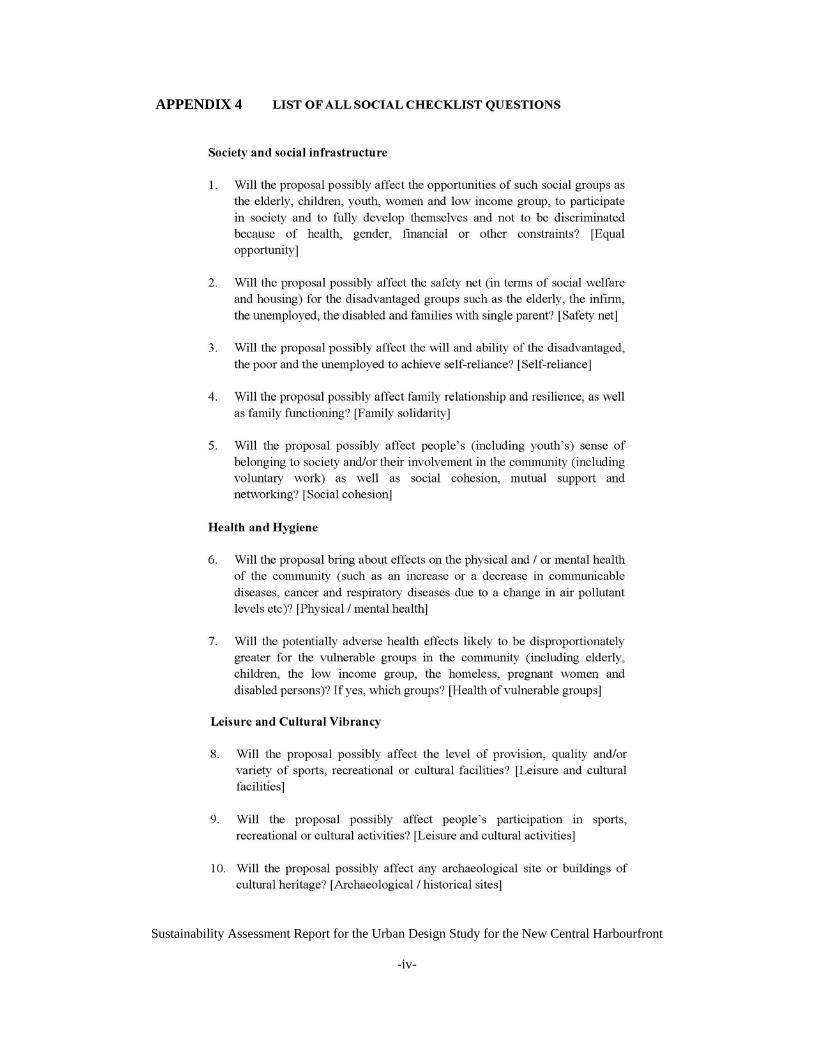
APPENDIX 4
Sustainability Assessment Report for the Urban Design Study for the New Central Harbourfront
-iv-

APPENDIX 5
Sustainability Assessment Report for the Urban Design Study for the New Central Harbourfront
-v-
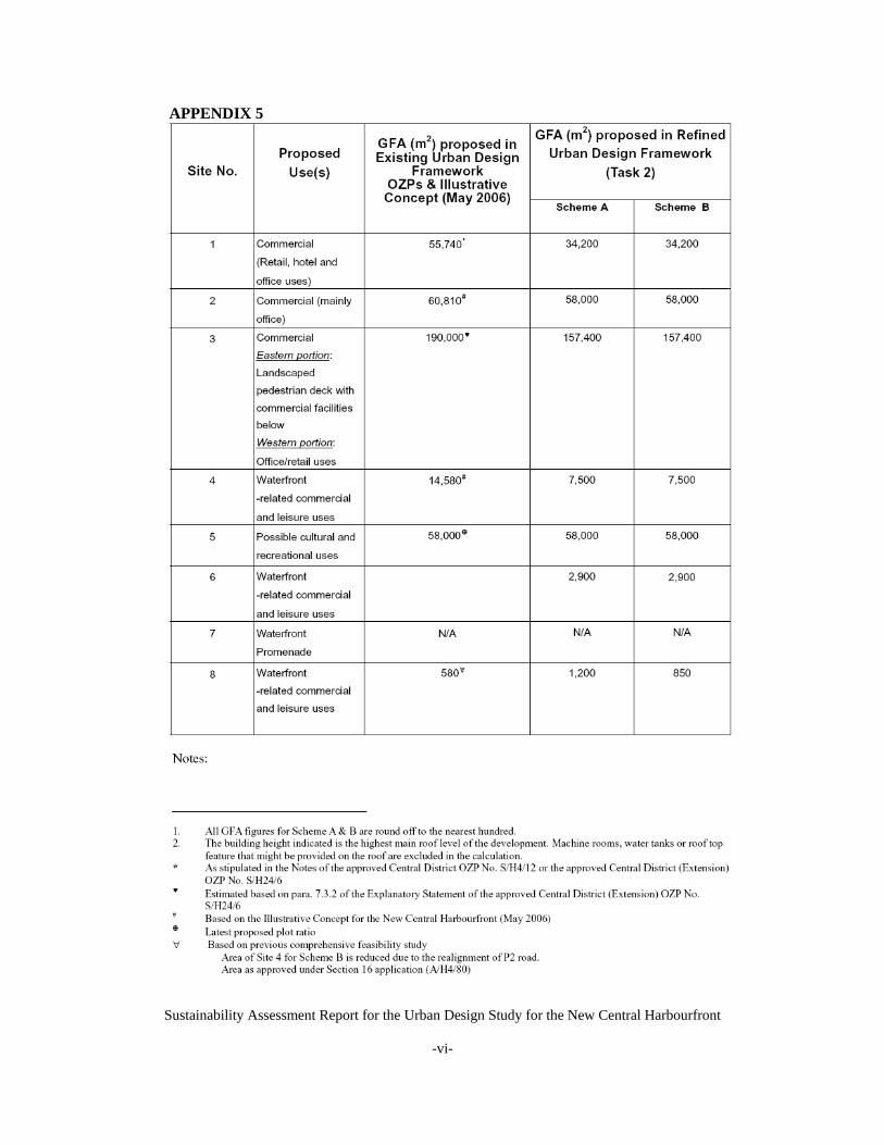
Sustainability Assessment Report for the Urban Design Study for the New Central Harbourfront
-vi-
APPENDIX 5