urban design review panel - formal submission - part 1 of 2
TRANSCRIPT


RIOCAN-TANGER OUTLET MALL | URBAN DESIGN REVIEW BRIEF
INTRODUCTION
This Design Review Brief was prepared in support of
Site Plan Control application for the lands municipally
known as 333 Huntmar Drive (the “subject property”
subject property is located on the north side of Highway
417 (the “Queensway”) between Huntmar Drive and
Palladium Drive.
THE SITE
The subject property has a total area of 23.86 hectares
and is bounded by the future Campeau Drive extension to
the north, Huntmar Drive to the east, Highway 417 to the
south, and Palladium Drive to the west. Feedmill Creek
runs in an east-west direction across the subject lands,
creating two parcels of land.
The majority of the subject lands are agricultural crop land
that was most recently ploughed in the late autumn of
2008. Less productive lands are located adjacent to the
Feedmill Creek valley and the lands closest to Highway
417. There are no buildings located on the subject lands,
however, farm remains, such as debris, barn/stal
foundations, and remnants of demolished buildings
occupy portions of the site.
Surrounding land uses are described as follows:
North
To the north of the subject property are future
development lands and agricultural lands.
URBAN DESIGN REVIEW BRIEF
ief was prepared in support of a
Plan Control application for the lands municipally
the “subject property”). The
north side of Highway
417 (the “Queensway”) between Huntmar Drive and
has a total area of 23.86 hectares
and is bounded by the future Campeau Drive extension to
Drive to the east, Highway 417 to the
south, and Palladium Drive to the west. Feedmill Creek
west direction across the subject lands,
The majority of the subject lands are agricultural crop land
ecently ploughed in the late autumn of
2008. Less productive lands are located adjacent to the
Feedmill Creek valley and the lands closest to Highway
417. There are no buildings located on the subject lands,
however, farm remains, such as debris, barn/stall
foundations, and remnants of demolished buildings
Surrounding land uses are described as follows:
To the north of the subject property are future
East
East of the subject property is additional future
development lands and the Carp River. These lands are
currently being developed as a low
subdivision by Minto Communities, supplemented by
future commercial and employment lands.
Further east, employment and r
located on the east side of the Carp River. The Kanata
Centrum large-format retail centre is on the east side of
Terry Fox Drive.
South
To the south of the subject lands are the Palladium
Autopark, Scotiabank Place, and future develop
lands. Further south are low
residential subdivisions currently under development
Mattamy Homes and the community of Stittsville.
West
Mineral aggregate extraction lands are located to the west
of the site. Further west is the Carp Waste Management
Facility.
PROPOSED DEVELOPMENT
RioCan and Tanger Outlets are proposing the construction
of a Tanger Retail Outlet Centre with associated surface
parking, a stand-alone retail/restaurant pad, and a
stormwater pond on the property to the north of the
Feedmill Creek. South of the creek, an eight
three (3) standalone full-service restaurants, and an
associated surface parking area are proposed.
1
property is additional future
development lands and the Carp River. These lands are
currently being developed as a low-rise residential
bdivision by Minto Communities, supplemented by
future commercial and employment lands.
Further east, employment and residential lands are
located on the east side of the Carp River. The Kanata
format retail centre is on the east side of
To the south of the subject lands are the Palladium
Autopark, Scotiabank Place, and future development
low and medium-density
currently under development by
and the community of Stittsville.
extraction lands are located to the west
of the site. Further west is the Carp Waste Management
RioCan and Tanger Outlets are proposing the construction
Outlet Centre with associated surface
alone retail/restaurant pad, and a
stormwater pond on the property to the north of the
South of the creek, an eight-storey hotel,
service restaurants, and an
associated surface parking area are proposed.

RIOCAN-TANGER OUTLET MALL | URBAN DESIGN REVIEW BRIEF
The Development Concept Plan contains a vibrant,
pedestrian-oriented, uniquely themed specialty retail
shopping venue in the Ottawa area. The proposed design
creates the ambience of an outdoor village street setting
with generous landscaping, the use of na
and intermittent structural building elements to protect
shoppers from weather.
The outlet center is comprised of eleven (11), 1
buildings which vary in size from 1,263m2 to 6,386m
total building area of 35,984m2 (gross leasa
32,809m2). The buildings are interconnected with
common, partially covered, walkways, and seating, and
landscaped areas. The stores are more similar in height to
traditional mainstreet stores (average building height of
7.3 m or 24 feet) than high-ceiling large format stores. The
majority of the units will be occupied by fashion retailers,
with a few food vendors.
Three (3) vehicular accesses are proposed for the
northern development parcel, including a right
out access off of Palladium Drive. One full
vehicular access off of Huntmar Drive is proposed for the
southern development parcel. Abutting roadways
including Campeau Drive and Huntmar Drive will be
characterized by new roundabout intersections.
facilitate vehicular and pedestrian movement between the
two (2) parcels, a bridge is proposed over Feedmill Creek
at its narrowest point. Sidewalks 1.5 metres in width are
proposed along both sides of the bridge.
Surface parking encircles the outlet center. A total of
2,077 vehicular parking spaces are proposed, which
reflects the vehicular-orientation of the outlet use
(regional scale retail) and its location abutting Highway
URBAN DESIGN REVIEW BRIEF
The Development Concept Plan contains a vibrant,
oriented, uniquely themed specialty retail
shopping venue in the Ottawa area. The proposed design
creates the ambience of an outdoor village street setting
with generous landscaping, the use of native materials,
and intermittent structural building elements to protect
The outlet center is comprised of eleven (11), 1-storey
to 6,386m2 for a
(gross leasable area of
The buildings are interconnected with
common, partially covered, walkways, and seating, and
The stores are more similar in height to
traditional mainstreet stores (average building height of
ceiling large format stores. The
majority of the units will be occupied by fashion retailers,
vehicular accesses are proposed for the
northern development parcel, including a right-in/right-
Drive. One full-movement
vehicular access off of Huntmar Drive is proposed for the
Abutting roadways
including Campeau Drive and Huntmar Drive will be
characterized by new roundabout intersections. To
pedestrian movement between the
parcels, a bridge is proposed over Feedmill Creek
at its narrowest point. Sidewalks 1.5 metres in width are
Surface parking encircles the outlet center. A total of
vehicular parking spaces are proposed, which
orientation of the outlet use
(regional scale retail) and its location abutting Highway
417, a highly visible transportation corridor. A total of 80
bicycle parking spaces are proposed at
western ends of the Outlet Centre.
Shoppers will be led from the parking area into the outlet
center at eight (8) entry points located around the
perimeter of the development. The same, unifying
materials are proposed at all of the entryway
each entryway has been designed to have a distinct look
for orientation purposes. A number of the entryways are
defined by an architectural feature which projects 16.5 to
23 metres (54 to 75 feet) above ground level, which
serves to identify the location of the entryways from a
distance.
2
417, a highly visible transportation corridor. A total of 80
bicycle parking spaces are proposed at the eastern and
western ends of the Outlet Centre.
Shoppers will be led from the parking area into the outlet
center at eight (8) entry points located around the
perimeter of the development. The same, unifying
materials are proposed at all of the entryways; however,
each entryway has been designed to have a distinct look
for orientation purposes. A number of the entryways are
defined by an architectural feature which projects 16.5 to
23 metres (54 to 75 feet) above ground level, which
e location of the entryways from a

RIOCAN-TANGER OUTLET MALL | URBAN DESIGN REVIEW BRIEF
URBAN DESIGN REVIEW BRIEF
3

RIOCAN-TANGER OUTLET MALL | URBAN DESIGN REVIEW BRIEF
RESPONSE TO INITIAL DESIGN REVIEW PANEL
RECOMMENDATIONS
On September 6, 2012, RioCan and Tanger Outlets, the
owners, Turner Fleischer Architects Inc.
Architecture, Planning & Design, the project
and FOTENN Consultants Inc. met with the Urban Design
Review Panel (UDRP) for a pre-application consultation
review of the project.
The UDRP reviewed proposed building elevations and site
layout and provided design direction for the proposed
project. The comments/areas of interest of the UDRP can
be summarized as follows:
• The internal layout of the shopping centre should
be changed in order to line up with the location of
the bridge across Feedmill Creek. This will serve to
facilitate a stronger connection between the hotel
complex and the shopping complex;
• Consider how to encourage active transportation;
• Focus on creating a sense of arrival or entry,
creating better wayfinding gestures, and providing
public gathering spaces to give the complex
sense of place;
• Consider the relocation of the food court from the
northwest corner of the development to the
southeast corner;
• Consider the key vistas from which this site will be
seen (Highway 417 and the adjacent residential
URBAN DESIGN REVIEW BRIEF
RESPONSE TO INITIAL DESIGN REVIEW PANEL
RioCan and Tanger Outlets, the
owners, Turner Fleischer Architects Inc. and CREATE
, the project architects,
and FOTENN Consultants Inc. met with the Urban Design
application consultation
The UDRP reviewed proposed building elevations and site
layout and provided design direction for the proposed
roject. The comments/areas of interest of the UDRP can
The internal layout of the shopping centre should
be changed in order to line up with the location of
the bridge across Feedmill Creek. This will serve to
er connection between the hotel
complex and the shopping complex;
Consider how to encourage active transportation;
Focus on creating a sense of arrival or entry,
creating better wayfinding gestures, and providing
public gathering spaces to give the complex a
Consider the relocation of the food court from the
northwest corner of the development to the
Consider the key vistas from which this site will be
seen (Highway 417 and the adjacent residential
subdivision). Give special attention to how to
create an attractive development from these vistas.
• Add additional height to the hotel making it act as
a symbolic element at a landmark gateway location
to the City;
• Explore ways to screen the parking;
INTERNAL LAYOUT
Entry 7 has been relocated to align directly with the
proposed bridge over Feedmill Creek
recommended this change to
connection between the hotel complex and the shopping
complex, provide shoppers with the opportunity to
appreciate the natural features of the ravine, and allow the
4
l attention to how to
create an attractive development from these vistas.
Add additional height to the hotel making it act as
a symbolic element at a landmark gateway location
Explore ways to screen the parking;
to align directly with the
bridge over Feedmill Creek. The UDRP
facilitate a stronger
connection between the hotel complex and the shopping
complex, provide shoppers with the opportunity to
natural features of the ravine, and allow the

RIOCAN-TANGER OUTLET MALL | URBAN DESIGN REVIEW BRIEF
retailers the option to take advantage of the natural
setting.
ACTIVE TRANSPORTATION
A Community Transportation Study (CTS) was completed
for the proposed Retail Outlet Centre and acknowledged
that there is currently no pedestrian or bicycle facilities in
the area. It also noted that transit service is limited in the
vicinity.
The proposed development begins the process of
introducing these facilities into the area. A 2.5 metre
sidewalk encircles the outlet centre on the Huntmar,
URBAN DESIGN REVIEW BRIEF
retailers the option to take advantage of the natural
A Community Transportation Study (CTS) was completed
Outlet Centre and acknowledged
rrently no pedestrian or bicycle facilities in
the area. It also noted that transit service is limited in the
begins the process of
introducing these facilities into the area. A 2.5 metre
sidewalk encircles the outlet centre on the Huntmar,
Palladium, and Campeau frontages. Major pedestrian
connections draw pedestrians from the street into Outlet
Centre, particularly at Entry 1 where a
bioswale has been added adjacent to the pathway
providing a natural connection with the ravine and
stormwater management pond.
A total of 80 bicycle parking spaces are proposed at the
east and west ends of the Outlet Centre, at entries 1
and 7. These spaces are located such that they are in
obvious locations increasing the security of bicycles
parked in them.
5
Palladium, and Campeau frontages. Major pedestrian
connections draw pedestrians from the street into Outlet
Centre, particularly at Entry 1 where a five (5) metre
bioswale has been added adjacent to the pathway –
providing a natural connection with the ravine and
A total of 80 bicycle parking spaces are proposed at the
east and west ends of the Outlet Centre, at entries 1, 4, 5,
and 7. These spaces are located such that they are in
obvious locations increasing the security of bicycles

RIOCAN-TANGER OUTLET MALL | URBAN DESIGN REVIEW BRIEF
CREATION OF A SENSE OF ENTRY AND PLACE
Each entrance has been designed to have a distinct look
for orientation purposes. A number of the entryways are
defined by an architectural feature which projects 16.5 to
23 metres above ground level.
The architecture of the proposed retail O
one (1) to two (2) storeys, providing a human scale
reminiscent of the streets in a village core. T
architectural style will be themed to offer an identity that
is specific to Ottawa and especially the Kanata area.
design approach includes natural materials which are in
keeping with the Carp River District, the defining natural
feature of the area. Stores are relatively small, with no
‘big-box’ retailers dominating the centre. A large portion
of the individual pedestrian streets are covered, to
provide shelter from rain, snow, or the hot sun, while still
maintaining the outdoor experience. Special paving
materials and lighting will provide visual variety while
helping shoppers orient themselves within the centre.
Large courtyards within
the Centre will provide a
place for shoppers to stop
and rest throughout their
experience. These areas
will continue with the
natural theme, using
elements from around
Feedmill Creek to connect
the experience with the
natural areas on the site.
Given the location of the
URBAN DESIGN REVIEW BRIEF
ENTRY AND PLACE
Each entrance has been designed to have a distinct look
number of the entryways are
defined by an architectural feature which projects 16.5 to
Outlet Centre is
storeys, providing a human scale
village core. The overall
will be themed to offer an identity that
is specific to Ottawa and especially the Kanata area. The
design approach includes natural materials which are in
the defining natural
Stores are relatively small, with no
box’ retailers dominating the centre. A large portion
of the individual pedestrian streets are covered, to
provide shelter from rain, snow, or the hot sun, while still
taining the outdoor experience. Special paving
materials and lighting will provide visual variety while
helping shoppers orient themselves within the centre.
subject property and its limited access to transit in the
near future, pedestrian access from the surrounding
streets has been given less importance in this initial plan.
However, as the Kanata West community develops, and
this situation changes, this type of retail outlet could be
intensified, building new buildings (and potential mix of
uses) within the current surface parking areas bringing
pedestrian areas closer to the streets. This would enhance
the experience of pedestrians arriving by transit or on foot
from the surrounding area in the future.
FOOD COURT RELOCATION
The Review Panel suggested that the food court proposed
for the northwest corner of the development be
to the southeast corner. The intent was to
the food court to interact with the natural elements
around the stormwater management pond and Feedmill
Creek.
Due to constraints with regards to the internal function of
the Outlet Centre, the relocation of the food court was not
6
subject property and its limited access to transit in the
near future, pedestrian access from the surrounding
streets has been given less importance in this initial plan.
However, as the Kanata West community develops, and
tuation changes, this type of retail outlet could be
intensified, building new buildings (and potential mix of
uses) within the current surface parking areas bringing
pedestrian areas closer to the streets. This would enhance
arriving by transit or on foot
from the surrounding area in the future.
The Review Panel suggested that the food court proposed
for the northwest corner of the development be relocated
intent was to allow users of
the food court to interact with the natural elements
around the stormwater management pond and Feedmill
Due to constraints with regards to the internal function of
the Outlet Centre, the relocation of the food court was not

RIOCAN-TANGER OUTLET MALL | URBAN DESIGN REVIEW BRIEF
possible. A playground has been added to Entry 7 in order
to promote the active use of the site in the area of
Feedmill Creek.
LANDMARK ELEMENT
The height of the proposed hotel was increased from 3
storeys to 8 storeys in response to the UDRP's comment
that this location is a major gateway to the City
therefore the hotel should be increased in height to act as
a symbolic element at a landmark location.
SCREEN PARKING
In a development of this type, the street edges are
typically adjacent to the parking lots, rather than buildings
and structures. In order to mitigate the visual impact,
generous planting, berms, and low walls will be used
around the periphery of the site. The stormwater
management pond has also been located adjacent to
Huntmar Drive to further enhance the natural appearance
of the edge condition while integrating into Feedmill
Creek.
The internal landscape treatment will include elements
that reinforce the theme of the retail area, including
benches, waste receptacles, lighting, planting, a variety of
surface treatments and features that enhance the sensual
experience of the users.
CITY OF OTTAWA OFFICIAL PLAN
The subject property is designated Mixed Use
the City of Ottawa Official Plan (2003, Consolidated).
Mixed Use Centre designation is applied to lands that are
strategically located along major roads and the City’s
URBAN DESIGN REVIEW BRIEF
. A playground has been added to Entry 7 in order
to promote the active use of the site in the area of
The height of the proposed hotel was increased from 3
in response to the UDRP's comment
is a major gateway to the City and
should be increased in height to act as
a symbolic element at a landmark location.
In a development of this type, the street edges are
typically adjacent to the parking lots, rather than buildings
and structures. In order to mitigate the visual impact,
generous planting, berms, and low walls will be used
The stormwater
management pond has also been located adjacent to
Huntmar Drive to further enhance the natural appearance
of the edge condition while integrating into Feedmill
The internal landscape treatment will include elements
e theme of the retail area, including
benches, waste receptacles, lighting, planting, a variety of
surface treatments and features that enhance the sensual
The subject property is designated Mixed Use Centre in
the City of Ottawa Official Plan (2003, Consolidated). The
Mixed Use Centre designation is applied to lands that are
strategically located along major roads and the City’s
rapid-transit network. It is intended that these areas
undergo substantial growth in the form of compact,
mixed-use development and that they become focal
points of activity at both the local and regional scales.
The proposed Site Plan fulfills policies 6, 7, 8, and 9 of
Section 3.6.2- Mixed-Use Centres of the Official Plan in
following ways:
- A variety of uses are proposed in adjacent buildings, including a retail outlet mall, a hotel, and multiple
restaurants. The subject lands are not assigned a
density target in Figure 2.3 of Section 2.2.2
Growth within the Urban Area of the Official Plan.
- The proposed retail outlet centre buildings are visually interesting. Notable features include a considerable
amount of glazing, varied storefronts, and unobtrusive
signage. The hotel and restaurant uses proposed south
of Feedmill Creek will also be of a high standard of
design.
- The interior of the Outlet Centre is pedestriandue to the scale of the retail buildings, the hard and
soft landscaping proposed in between the buildings,
the separation of pedestrians from vehi
provision of public art, appropriate lighting, and
gathering areas which offer seating.
- Pedestrian connections, including both east
connections between Palladium Drive and Huntmar
Drive, and north-south connections across Feedmill
Creek, are proposed.
- Despite the Transportation Master Plan plans for transit stations in the area surrounding the subject
7
transit network. It is intended that these areas
growth in the form of compact,
use development and that they become focal
points of activity at both the local and regional scales.
The proposed Site Plan fulfills policies 6, 7, 8, and 9 of
Use Centres of the Official Plan in the
A variety of uses are proposed in adjacent buildings,
including a retail outlet mall, a hotel, and multiple
restaurants. The subject lands are not assigned a
density target in Figure 2.3 of Section 2.2.2- Managing
n Area of the Official Plan.
The proposed retail outlet centre buildings are visually
interesting. Notable features include a considerable
amount of glazing, varied storefronts, and unobtrusive
signage. The hotel and restaurant uses proposed south
ill Creek will also be of a high standard of
The interior of the Outlet Centre is pedestrian-friendly
due to the scale of the retail buildings, the hard and
soft landscaping proposed in between the buildings,
the separation of pedestrians from vehicles, and the
provision of public art, appropriate lighting, and
gathering areas which offer seating.
Pedestrian connections, including both east-west
connections between Palladium Drive and Huntmar
south connections across Feedmill
Despite the Transportation Master Plan plans for
transit stations in the area surrounding the subject

RIOCAN-TANGER OUTLET MALL | URBAN DESIGN REVIEW BRIEF
lands, these stations are not yet identified on Schedule
2A or 2B of the Comprehensive Zoning By
therefore maximum parking space rates do not apply.
- The proposed surface parking areas do not preclude the intensification of the subject lands at a later date,
which would improve pedestrian-, cyclist
accessibility and provide stronger street edges along
the public roads (see the Future Concept Plan for a
hypothetical future build out scenario).
- No outdoor storage is proposed.
- Given the low-rise nature of the majority of the proposed development, a transition to adjacent lands
is not necessary. The proposed 8-storey hotel is
located immediately adjacent to Highway 417, which
acts as a buffer to adjacent land uses, which includes
Scotiabank Place.
KANATA WEST CONCEPT PLAN
The subject lands are designated High Profile
Employment, Entertainment and Leisure Hub, Intensive
Employment Area, and River/Creek Corridors in the
Kanata West Concept Plan.
The High Profile Employment, Entertainment and Leisure
Hub designation reflects the close proximity of both
Highway 417 and the future Transitway. The entertainment
and leisure component reinforces the presence of the
Scotiabank Place sports and entertainment complex,
which is located southeast of the subject lands. A range of
uses are recommended within this designation, including
employment, personal and community-
URBAN DESIGN REVIEW BRIEF
lands, these stations are not yet identified on Schedule
2A or 2B of the Comprehensive Zoning By-law and
ates do not apply.
The proposed surface parking areas do not preclude
the intensification of the subject lands at a later date,
, cyclist- and transit-
accessibility and provide stronger street edges along
e the Future Concept Plan for a
hypothetical future build out scenario).
rise nature of the majority of the
proposed development, a transition to adjacent lands
storey hotel is
located immediately adjacent to Highway 417, which
acts as a buffer to adjacent land uses, which includes
The subject lands are designated High Profile
Employment, Entertainment and Leisure Hub, Intensive
Employment Area, and River/Creek Corridors in the
The High Profile Employment, Entertainment and Leisure
he close proximity of both
The entertainment
and leisure component reinforces the presence of the
Scotiabank Place sports and entertainment complex,
which is located southeast of the subject lands. A range of
recommended within this designation, including
-servicing uses,
leisure and entertainment uses, retail and theme/specialty
commercial, hotels and spas, and apartments.
It is intended that the highest intensity uses, such
offices, hotels and high-rise apartments, will be located at
the Highway 417/Huntmar Drive interchange, in order to
create a visual gateway to the area. Outward from this
high intensity centre, free standing, lower profile uses with
a strong pedestrian orientation to the street are
encouraged. Both sub-areas are expected to intensify
over time, particularly on sites initially used for surface
parking, resulting in an urban profile. At full build
building heights at the Highway 417/Huntmar interchang
are expected to range from 10 to 15 storeys.
In terms of urban design guidelines specific to this
designation, the KWCP encourages the incorporation of
semi-public spaces such as plazas and courts; the
development of paths along the banks of Feedmill Cre
which are connected via a pedestrian bridge crossing the
ravine; pedestrian accommodation through the provision
of continuous sidewalks, tree plantings, and appropriate
lighting; defined street corners by bringing buildings up to
the lot line; and landscaping the area in between
buildings.
Buildings with entertainment and leisure uses are
expected to have very clear entrances and convey a sense
of the urban recreation which is available within a cluster
of these types of buildings, creating a unique cha
and distinctive marketing attraction for the district. In
order to encourage evening activity, a theme of
pedestrian light standards, building lighting, and animated
signs is encouraged.
8
leisure and entertainment uses, retail and theme/specialty
commercial, hotels and spas, and apartments.
It is intended that the highest intensity uses, such as
rise apartments, will be located at
the Highway 417/Huntmar Drive interchange, in order to
create a visual gateway to the area. Outward from this
high intensity centre, free standing, lower profile uses with
orientation to the street are
areas are expected to intensify
over time, particularly on sites initially used for surface
parking, resulting in an urban profile. At full build-out,
building heights at the Highway 417/Huntmar interchange
are expected to range from 10 to 15 storeys.
In terms of urban design guidelines specific to this
designation, the KWCP encourages the incorporation of
public spaces such as plazas and courts; the
development of paths along the banks of Feedmill Creek,
which are connected via a pedestrian bridge crossing the
ravine; pedestrian accommodation through the provision
of continuous sidewalks, tree plantings, and appropriate
lighting; defined street corners by bringing buildings up to
scaping the area in between
Buildings with entertainment and leisure uses are
expected to have very clear entrances and convey a sense
of the urban recreation which is available within a cluster
of these types of buildings, creating a unique character
and distinctive marketing attraction for the district. In
order to encourage evening activity, a theme of
pedestrian light standards, building lighting, and animated

RIOCAN-TANGER OUTLET MALL | URBAN DESIGN REVIEW BRIEF
The intent of the Intensive Employment Area
is to provide a high quality environment for the high
technology sector and supporting uses. Uses
recommended in this designation include employment
uses, personal and community-servicing uses, retail and
specialty commercial.
In terms of design guidelines, the KWCP encourages an
urban grid street pattern with a long east
blocks with lengths approximately twice their width.
Regularly spaced connections across major streets are
also supported to create porosity throughout the area.
Similar to in the High Profile Hub, small “vest pocket”
parks, entry plazas, and courts are desired to provide
semi-public space and recreation paths along Feedmill
Creek are encouraged. Further, to achieve a pedestrian
friendly environment, the KWCP again promotes bringin
buildings up to lot lines and street corners and providing
appropriate sidewalk widths, tree plantings, and lighting.
Both the High Profile Employment, Entertainment and
Leisure Hub and the Intensive Employment Area KWCP
designations permit retail and th
commercial and the former designation also permits
leisure and entertainment uses, which includes
restaurants, as well as hotels and spas. Further, the
proposed uses fulfill the KWCP intent to have urban
amenities and recreation, such as rest
shopping, in this area in order to extend the visits of local
employees and visitors to Scotiabank Place.
The proposed outlet center, hotel, and restaurant uses are
permitted uses which serve to fulfill the vision of the
KWCP to have a "bright lights" district in this area of
Kanata West. However, the proposed design for the
URBAN DESIGN REVIEW BRIEF
the Intensive Employment Area designation
provide a high quality environment for the high
technology sector and supporting uses. Uses
gnation include employment
servicing uses, retail and
KWCP encourages an
long east-west axis and
blocks with lengths approximately twice their width.
Regularly spaced connections across major streets are
also supported to create porosity throughout the area.
High Profile Hub, small “vest pocket”
parks, entry plazas, and courts are desired to provide
public space and recreation paths along Feedmill
Creek are encouraged. Further, to achieve a pedestrian
friendly environment, the KWCP again promotes bringing
buildings up to lot lines and street corners and providing
appropriate sidewalk widths, tree plantings, and lighting.
Both the High Profile Employment, Entertainment and
Leisure Hub and the Intensive Employment Area KWCP
designations permit retail and theme/specialty
commercial and the former designation also permits
leisure and entertainment uses, which includes
restaurants, as well as hotels and spas. Further, the
proposed uses fulfill the KWCP intent to have urban
amenities and recreation, such as restaurants and
shopping, in this area in order to extend the visits of local
employees and visitors to Scotiabank Place.
The proposed outlet center, hotel, and restaurant uses are
permitted uses which serve to fulfill the vision of the
lights" district in this area of
Kanata West. However, the proposed design for the
subject lands represents a departure from the KWCP
designation-specific guidelines. In particular, the proposed
development is not set on an urban grid pattern of roads
and proposed heights are significantly lower than the 10
15 storey range expected for the lands closest to Highway
417 and Huntmar Drive. This departure is a result of the
unique nature of the Tanger Outlet Center, a use which
was not specified when the Kanata
was completed in 2002 (beyond the parameter of a
unique, specialty retail use) and from current market
conditions. The proposed design incorporates a notable
amount of surface parking and therefore does not
preclude the future intensification of this area.
CITY OF OTTAWA ZONING BY
The subject lands are currently zoned Development
Reserve Zone (DR) in the City of Ottawa Comprehensive
Zoning By-law (2008-250). A Zoning By
application was approved by Council
02-11-0128), to rezone the lands
Reserve Zone (DR) to Mixed-Use Centre Zone (MC).
amendment is currently proceeding
prescribed appeal period.
URBAN DESIGN CRITERIA
The proposed development does not
vision for the subject property as detailed within the
Kanata West Concept Plan but the Outlet Centre use is
not contemplated within that document.
As part of a Plan of Subdivision Application for the subject
lands, a Design Booklet/Brief dated January 2013 was
submitted to the City on January 29, 2013. This booklet
9
subject lands represents a departure from the KWCP
specific guidelines. In particular, the proposed
development is not set on an urban grid pattern of roads
proposed heights are significantly lower than the 10-
15 storey range expected for the lands closest to Highway
417 and Huntmar Drive. This departure is a result of the
unique nature of the Tanger Outlet Center, a use which
was not specified when the Kanata West Concept Plan
was completed in 2002 (beyond the parameter of a
unique, specialty retail use) and from current market
conditions. The proposed design incorporates a notable
amount of surface parking and therefore does not
ation of this area.
BY-LAW
The subject lands are currently zoned Development
Reserve Zone (DR) in the City of Ottawa Comprehensive
Zoning By-law Amendment
was approved by Council in March 2013 (D02-
to rezone the lands from Development
Use Centre Zone (MC). This
proceeding through the
The proposed development does not fully respond to the
vision for the subject property as detailed within the
Kanata West Concept Plan but the Outlet Centre use is
not contemplated within that document.
As part of a Plan of Subdivision Application for the subject
f dated January 2013 was
submitted to the City on January 29, 2013. This booklet
RIOCAN-TANGER OUTLET MALL | URBAN DESIGN REVIEW BRIEF
discussed urban design elements of the proposed
development and suggested several criteria.
The following is an excerpt from this Design Booklet/Brief:
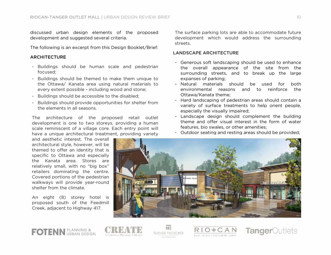
ARCHITECTURE
- Buildings should be human scale and pedestrian focused;
- Buildings should be themed to make them unique to the Ottawa/ Kanata area using natural materials to
every extent possible - including wood and stone;
- Buildings should be accessible to the disabled;
- Buildings should provide opportunities for shelter from the elements in all seasons.
The architecture of the proposed retail outlet
development is one to two storeys, providing a human
scale reminiscent of a village core. Each entry point will
have a unique architectural treatment, providing variety
and aesthetic interest. The overall
architectural style, however, will be
themed to offer an identity that is
specific to Ottawa and especially
the Kanata area. Stores are
relatively small, with no “big box”
retailers dominating the centre.
Covered portions of the pedestrian
walkways will provide year-round
shelter from the climate.
An eight (8) storey hotel is
proposed south of the Feedmill
Creek, adjacent to Highway 417.
URBAN DESIGN REVIEW BRIEF
discussed urban design elements of the proposed
development and suggested several criteria.
The following is an excerpt from this Design Booklet/Brief:
s should be human scale and pedestrian
Buildings should be themed to make them unique to
the Ottawa/ Kanata area using natural materials to
including wood and stone;
Buildings should be accessible to the disabled;
Buildings should provide opportunities for shelter from
The architecture of the proposed retail outlet
development is one to two storeys, providing a human
scale reminiscent of a village core. Each entry point will
unique architectural treatment, providing variety
The surface parking lots are able
development which would address the surrounding
streets.
LANDSCAPE ARCHITECTURE
- Generous soft landscaping should be used to enhance the overall appearance of the site from the
surrounding streets, and to break up the large
expanses of parking;
- Natural materials should be used for both
environmental reasons and to reinforce the
Ottawa/Kanata theme;
- Hard landscaping of pedestrian areas should contain a variety of surface treatments to help orient people,
especially the visually impaired;
- Landscape design should complement the building theme and offer visual interest in the form of water
features, bio swales, or other amenities;
- Outdoor seating and resting areas should be provided;
10
to accommodate future
development which would address the surrounding
Generous soft landscaping should be used to enhance
the overall appearance of the site from the
surrounding streets, and to break up the large
Natural materials should be used for both
environmental reasons and to reinforce the
Hard landscaping of pedestrian areas should contain a
variety of surface treatments to help orient people,
impaired;
Landscape design should complement the building
theme and offer visual interest in the form of water
features, bio swales, or other amenities;
Outdoor seating and resting areas should be provided;

RIOCAN-TANGER OUTLET MALL | URBAN DESIGN REVIEW BRIEF
- Hard landscaping should be designed to facilitatemaintenance, particularly snow clearing.
The proposed development will have
landscaping around the periphery of the site, using trees,
shrubs, berms and/or low walls where appropriate. The
internal landscape treatments will include elements th
reinforce the theme of the retail area, including benches,
waste receptacles, lighting, planting, and a variety of
surface treatments and features that enhance the sensual
experience of the users.
EDGES
- Edges should be landscaped with plants, berms, and/or low decorative walls to reduce the visibility of
parking lots;
- Entrances to the site should be enhances with additional lighting, themed signage, and further
landscaping;
- Maintaining the potential to development uses of a more intense nature around the perimeter of the site,
with buildings up to 10-15 storeys fronting on the
surrounding streets.
In a development of this type, the street edges are
typically adjacent to the parking lots, rather than buildings
and structures. In order to mitigate the visu
generous planting, berms, and low walls will be used. The
location of the stormwater management pond adjacent to
Huntmar further enhances the natural appearance of the
edge condition, and integrates well into Feedmill Creek.
Gateway features will highlight the entrances to the site
by incorporating lighting and signage, as well as enhanced
URBAN DESIGN REVIEW BRIEF
Hard landscaping should be designed to facilitate
maintenance, particularly snow clearing.
The proposed development will have significant
landscaping around the periphery of the site, using trees,
shrubs, berms and/or low walls where appropriate. The
internal landscape treatments will include elements that
reinforce the theme of the retail area, including benches,
waste receptacles, lighting, planting, and a variety of
surface treatments and features that enhance the sensual
Edges should be landscaped with plants, berms,
d/or low decorative walls to reduce the visibility of
Entrances to the site should be enhances with
additional lighting, themed signage, and further
Maintaining the potential to development uses of a
e perimeter of the site,
15 storeys fronting on the
In a development of this type, the street edges are
typically adjacent to the parking lots, rather than buildings
and structures. In order to mitigate the visual impact,
generous planting, berms, and low walls will be used. The
location of the stormwater management pond adjacent to
Huntmar further enhances the natural appearance of the
edge condition, and integrates well into Feedmill Creek.
ll highlight the entrances to the site
by incorporating lighting and signage, as well as enhanced
landscaping to draw attention to the entrances as they
penetrate the edge conditions and lead into the site.
This type of centre also permits future developm
occur around the edges. That development could take the
form of other uses, such as office or residential, with
underground or structured parking to serve both the retail
outlet and the additional uses. Those additional uses could
be accommodated in taller buildings, if appropriate, with
the retail outlet serving as the “village centre”, providing a
lively gathering place for the surrounding residents and/or
employees.
VEHICULAR CIRCULATION AND PARKING
- Multiple access points should be designed to mipotential congestion on public streets;
- Internal circulation should clearly separate vehicles from pedestrians to ensure safe and comfortable
walking;
- Parking lots should be separated into discreet areas using landscaping to reduce their visual impa
make navigation more intuitive;
- Parking lots should be adequately lit environment, while avoiding light pollution;
- Layout of the parking lots and drive aisles should not preclude future phased development of those lots with
new buildings and structured parking (either above or
below ground) on a modified grid.
Internal vehicular circulation takes the form of a ring road
around the outside of the Outlet Centre
easily accessible from all sides. The parking lots are la
out as “rooms” providing discreet areas that have the
potential to be separated by landscaped islands. There are
11
landscaping to draw attention to the entrances as they
penetrate the edge conditions and lead into the site.
This type of centre also permits future development to
occur around the edges. That development could take the
form of other uses, such as office or residential, with
underground or structured parking to serve both the retail
outlet and the additional uses. Those additional uses could
taller buildings, if appropriate, with
the retail outlet serving as the “village centre”, providing a
lively gathering place for the surrounding residents and/or
VEHICULAR CIRCULATION AND PARKING
Multiple access points should be designed to mitigate
potential congestion on public streets;
Internal circulation should clearly separate vehicles
from pedestrians to ensure safe and comfortable
Parking lots should be separated into discreet areas
using landscaping to reduce their visual impact and to
make navigation more intuitive;
Parking lots should be adequately lit to provide a safe
environment, while avoiding light pollution;
Layout of the parking lots and drive aisles should not
preclude future phased development of those lots with
buildings and structured parking (either above or
below ground) on a modified grid.
Internal vehicular circulation takes the form of a ring road
Outlet Centre, with parking
easily accessible from all sides. The parking lots are laid
out as “rooms” providing discreet areas that have the
potential to be separated by landscaped islands. There are

RIOCAN-TANGER OUTLET MALL | URBAN DESIGN REVIEW BRIEF
three (3) main access points into the site and one
secondary access point from the development south of
the site, which includes the proposed hotel. Two (2) of the
access point are from Campeau Drive and are full turning
movement intersections. The access from Huntmar is a
right-in, right-out intersection. All of the access roads
provide generous stacking lanes for busy periods to avoid
creating congestion on surrounding roads. The location
and design of the access will be subject to municipal
approval.
PEDESTRIAN CIRCULATION
- Pedestrians should be clearly separated from vehicles to every extent possible;
- The ‘pedestrian realm’ should be at a human scale;
- Pedestrians should have ready access to shelter from the elements;
- Safe and convenient pedestrian links to surrounding streets should be provided;
- Site lighting will have a consistent, decorative
appearance throughout the site;
- Pedestrian links should anticipate future development of the site and the future provision of adjacent public
transit.
Pedestrian circulation is internal to the shopping area,
located within the corridors between the retail buildings.
Large, inviting entry points lead pedestrians from the
parking areas to the shopping “streets”. A large portion of
the individual pedestrian streets are covered, to provide
shelter from rain, snow, or the hot sun, while still
maintaining the outdoor experience. Special paving
URBAN DESIGN REVIEW BRIEF
three (3) main access points into the site and one
secondary access point from the development south of
d hotel. Two (2) of the
access point are from Campeau Drive and are full turning
movement intersections. The access from Huntmar is a
out intersection. All of the access roads
provide generous stacking lanes for busy periods to avoid
ng congestion on surrounding roads. The location
and design of the access will be subject to municipal
Pedestrians should be clearly separated from vehicles
uman scale;
Pedestrians should have ready access to shelter from
Safe and convenient pedestrian links to surrounding
Site lighting will have a consistent, decorative
should anticipate future development
of the site and the future provision of adjacent public
Pedestrian circulation is internal to the shopping area,
located within the corridors between the retail buildings.
estrians from the
parking areas to the shopping “streets”. A large portion of
pedestrian streets are covered, to provide
shelter from rain, snow, or the hot sun, while still
maintaining the outdoor experience. Special paving
materials and lighting will provide visual variety while
helping shoppers orient themselves within the centre.
Given the location of this site and the limited access to
public transit in the near future, the majority of shoppers
will arrive by private automobile, giving
from the surrounding streets less importance. However, as
this situation changes over time, this type of retail outlet
could be expanded, either with additional retail or other
uses as previously discussed, to bring pedestrian areas
closer to the streets by replacing some surface lots with
underground or structured parking. This would enhance
the experience of pedestrians arriving by transit or on foot
from the surrounding area in the future.
FUTURE EXPANSION
- Future expansion can take plaareas, replacing lost parking and creating parking lots
for new uses in structures (either below or above
ground);
- Buildings could be between 10 and 15 storeys;- New buildings should be mixedprovide diversity and activity on the site.
12
ghting will provide visual variety while
helping shoppers orient themselves within the centre.
Given the location of this site and the limited access to
public transit in the near future, the majority of shoppers
will arrive by private automobile, giving pedestrian access
from the surrounding streets less importance. However, as
this situation changes over time, this type of retail outlet
could be expanded, either with additional retail or other
uses as previously discussed, to bring pedestrian areas
r to the streets by replacing some surface lots with
underground or structured parking. This would enhance
the experience of pedestrians arriving by transit or on foot
from the surrounding area in the future.
Future expansion can take place in surface parking
areas, replacing lost parking and creating parking lots
for new uses in structures (either below or above
Buildings could be between 10 and 15 storeys;
New buildings should be mixed-use buildings to
vity on the site.
SUSTAINABILITY FEATURES 1. STORMWATER MANAGEMENT
2. PLANTING MATERIAL
3. PAVING + SITE FURNISHINGS
4. TRANSPORTATION
5. ARCHITECTURE

STORMWATER MANAGEMENT
BIOSWALE [Strategic Locations] SW FILTRATION + INFILTRATION Bioswales are shallow grass-covered hydraulic conveyance channels that help to slow runoff and facilitate infiltration. Use of natural, low-lying areas is encouraged and natural drainage courses should be preserved and utilized.
GREEN ROOF [Strategic Locations] RUNOFF REDUCTION + HEAT ISLAND In addition to reducing runoff volume and frequency and improving runoff water quality, a green roof can reduce the effects of atmospheric pollution, reduce energy costs, and create an attractive environment.
RAIN BARRELS + CISTERNS SW HARVESTING + H2O USE REDUCTION Rainwater collected in cisterns may be used in lawn and garden irrigation and other non-potable water applications such as toilet flushing. Both cisterns and rain barrels can be implemented without the use of pumping devices by relying on gravity flow instead.
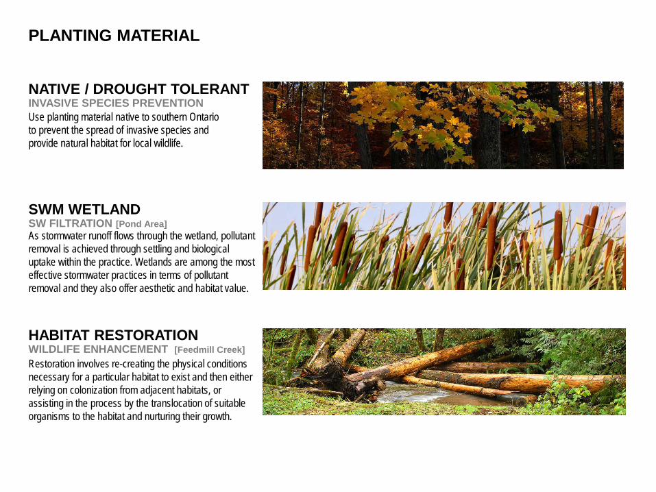
PLANTING MATERIAL
NATIVE / DROUGHT TOLERANT INVASIVE SPECIES PREVENTION Use planting material native to southern Ontario to prevent the spread of invasive species and provide natural habitat for local wildlife.
SWM WETLAND SW FILTRATION [Pond Area] As stormwater runoff flows through the wetland, pollutant removal is achieved through settling and biological uptake within the practice. Wetlands are among the most effective stormwater practices in terms of pollutant removal and they also offer aesthetic and habitat value.
HABITAT RESTORATION WILDLIFE ENHANCEMENT [Feedmill Creek] Restoration involves re-creating the physical conditions necessary for a particular habitat to exist and then either relying on colonization from adjacent habitats, or assisting in the process by the translocation of suitable organisms to the habitat and nurturing their growth.

PAVING + SITE FURNISHINGS
PERMEABLE PAVING SW INFILTRATION [Strategic Locations] Permeable pavement is an alternative to asphalt or concrete surfaces that allows stormwater to drain through the porous surface to a stone reservoir underneath. The reservoir temporarily stores surface runoff before infiltrating it into the subsoil.
LIGHT COLOUR PAVING HEAT ISLAND REDUCTION Choose paver with Solar Reflective Index of 29 or higher to reduce the heat island effect caused by hard surface construction material.
SUSTAINABLE / RECYCLED CARBON FOOTPRINT REDUCTION Use environmentally certified or recycled materials in construction and site furnishing products to reduce carbon footprint of the project.

PAVING + SITE FURNISHINGS CONTINUED.
RECYCLING SOLID WASTE REDUCTION Promote recycling program to reduce amount of solid waste going into the landfill.
100% DOWN LIGHTING LIGHT POLLUTION ELIMINATION Light pollution is excessive or obtrusive artificial light, it causes the degradation of photic habitat by artificial light. Use of 100% down lighting and directional lighting will significantly reduce the light spill.
LOCAL MATERIAL CARBON FOOTPRINT REDUCTION All site construction materials and site furnishing should be extracted, processed, and manufactured within a 500 mile radius of the site when possible to reduce carbon footprint of the project.

TRANSPORTATION
PUBLIC TRANSIT EMISSIONS REDUCTION Promote timely local and regional public transportation system to encourage less driving.
BIKE LANE EMISSIONS REDUCTION Designated bike lane to link adjacent local communities to encourage more active lifestyle and reduce emissions.
PEDESTRIAN WALKWAY PEDESTRIAN FRIENDLY Design pedestrian walkways to connect communities, parking lots and adjacent developments to suit human comfort levels in all seasons.

ARCHITECTURE
REDUCTION OF HEAT ISLAND ROOFS AND BUILDING SURFACES Roofing surface with high albedo (light in colour) and potential feature elements such as green screens (areas of vertical planting).
WATER WATER EFFICIENCY Specifying fixtures and appliances that are low flow or waterless reduces the amount of overall water consumption, saving water and money.
EDUCATION EDUCATIONAL SIGNAGE Implement signage or plaques to educate the occupants about the sustainable design, systems, maintenance, and use of environmentally friendly material.

ARCHITECTURE CONTINUED.
MATERIALS SELECTION Design will incorporate some materials and products that are recyclable, renewable, reclaimed, non-toxic, and locally produced
ENERGY ENERGY EFFICIENCY Use elements such as natural lighting, lighting controls, and energy efficient appliances and water heaters to reduce demand on traditional power and gas sources for public spaces and reduce greenhouse gases

PLANS
1. CONTEXT PLAN
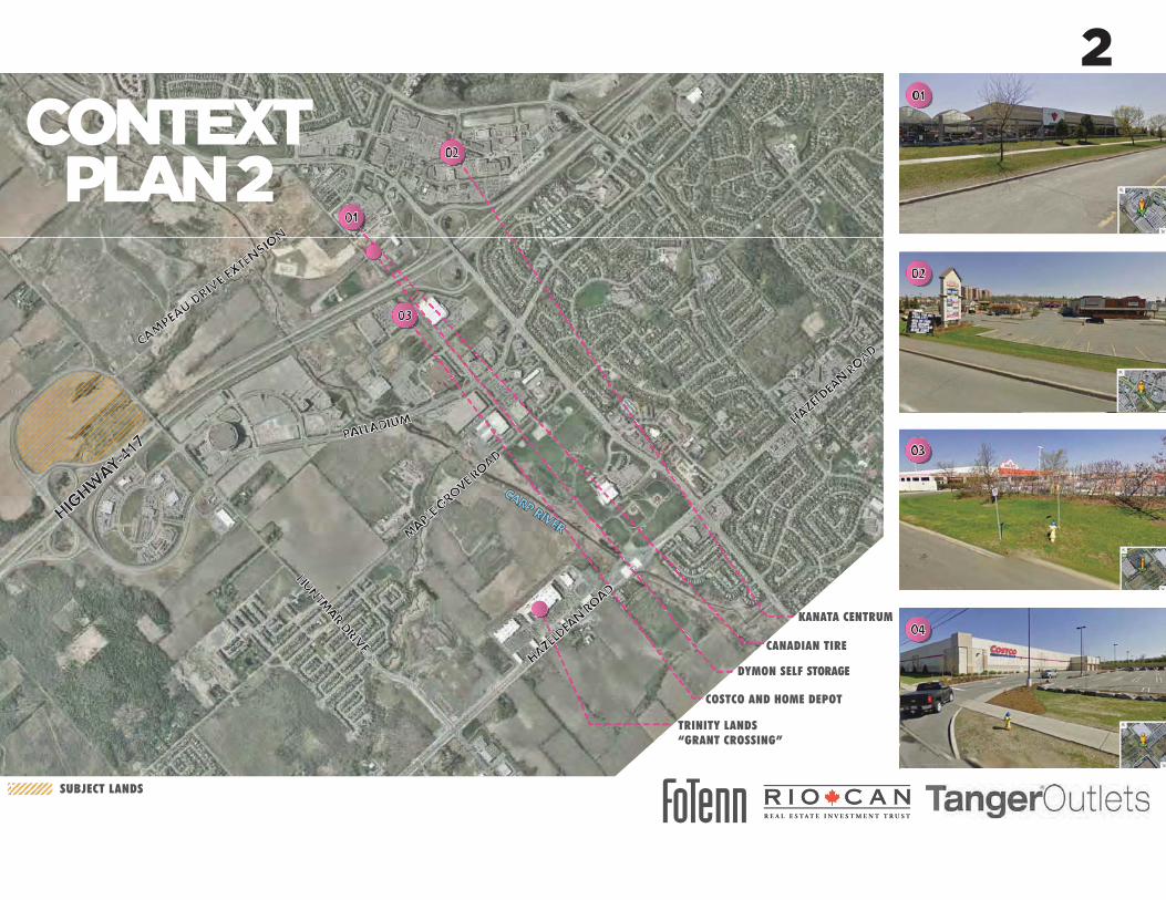
2. CONTEXT PLAN 2
3. SITE PLAN
4. FUTURE CONCEPT PLAN
5. OVERALL LANDSCAPE
6. GENERAL PLAN OF SERVICES
FUTURE CONCEPT PLAN
OVERALL LANDSCAPE KEY PLAN
GENERAL PLAN OF SERVICES

URBAN B
OUN
DARY
BELL SENSPLEX +WALTER BAKER PARK
SCOTIABANK PLACE
KANATA CENTRUM
PALLADIUM AUTOPARK
TAGGART FUTURE OFFICE PARK
LIMESTONE QUARRY
SUBJECT LANDS
FUTURE BRT CORRIDOR+STATIONS
WASTE MANAGEMENT LANDFILL
MAPL
E GRO
VE RO
AD
PALLADIUMDRIVE
CAM
PEAU
CARP RO
AD
HUN
TMAR DRIVE
CA
RP R
IVER
CAMPEA
U DRIV
E EX
TEN
SION
RICHARDSO
N S
IDE
ROAD
DRIV
E
GRGR
HIGHW
AY-417
CONTEXTPLAN TERRY FO
X DRIVE
1
CONTEXTPLAN 2
TRINITY LANDS “GRANT CROSSING”
DYMON SELF STORAGE
COSTCO AND HOME DEPOT
CANADIAN TIRE
KANATA CENTRUM
SUBJECT LANDS
4
2

BUILDING 05BUILDING 07
BUILDING 01
BUILDING 03
BU
ILD
ING
04
BUILDING 09
BUILDING 08
BUILDING 02
109728 152400
109729 10972 45110
5181
6
111710
7315
2
122072
3048
030
480
3047
7
121921
3047
9
12192 30480
( 366' - 6" )
( 40' - 0" )( 100' - 0" )
( 10
0' -
0"
)
( 400' - 0" )
( 10
0' -
0"
)(
170'
- 0
" )
( 360' - 0" )
( 500' - 0" )
( 10
0' -
0"
)
( 10
0' -
0"
)
( 360' - 0" )
( 24
0' -
0"
)
( 400' - 6" )
( 17
0' -
0"
)51
816
BLDG. AREA ±59,975 S.F.LEASEABLE AREA ±51,244 S.F.
OUTPARCEL 01±1.15 ACRES
FIRE TRUCK ROUTEHEAVY DUTY ASPHALT
FIRE TRUCK ROUTEHEAVY DUTY ASPHALT
FIRE TRUCK ROUTEHEAVY DUTY ASPHALT
FIRE TRUCK ROUTEHEAVY DUTY ASPHALT
FIR
E T
RU
CK
RO
UT
EH
EA
VY
DU
TY
AS
PH
ALT
POND AREA
5200
6700
2258
4160
037
4091
4430
4812
189
1097
310
973
1219
230
4891
44
9000
4500
5200
6700
5200
5200
6700
5200
5200
6700
5200
360150
8667
0052
0052
0067
0052
0052
0067
0052
0052
0067
0052
00
5200 6700 10400 6700 10400 6700 289115600 2005
67005200
1523
891
4427
4226
000
2600
1820
0
1219
030
4891
4427
4254
600
70200 2648 9144 3048 9307
5200 6700
67005200
6700
5200
TYP.
2600
TYP.
3900
4160
027
3691
44
9144
3048
9165
5 2006700
5200 5200 6700 5200 5200 6700 5200 5200 6700 5200 5200 6700 5200 5200 6700 5200 5200 6700 5200 5200 6700 05200 5200 6700 5200 11394 8840 4617 8620
5200 6700 5200 5200 6700 5200 5200 6700 5200 5200 6700 5200 5200 6700 5200 5200 6700 5200 5200 6700 5200 5200 6700 5200 65000 3800 41600
1097
3
17136
15088
15088
1097
3
9423 49683 10846
10973
5181 6
1500
100010001500
182880
1000
1000
1000
1000
100010
00
10001000
1000
1000
1000
1500
1665
1665
1000
1100
10001400
11001100
11001100
11001100
11001100
11001100
11001100
1400
1325
9000
1500
9000
1000
1000
115765
30480
1097
3
9144
1585
1785
1785
1000
1589
1589
2074
20742074
2074
10001000
1900
1900
1900
1900
1900
1900
1900
1900
1900
1925
1925
1925
1925
1925
1925
19251329
1329
1329
1329
10001000
1129
11291129
11291129
1129
182880
PA
LL
AD
IUM
DR
IVE
CAMPEAU DRIVE
835 CARS
424 CARS
449 CARS
HIGHWAY #417
FEEDMILL CREEKBUFFER AREA
ROOF ABOVE
ROOF ABOVE
ROOF ABOVE
ROOF ABOVE
RO
OF
AB
OV
E
RO
OF
AB
OV
E
4572 30
4845
72
2500
0
3700
09144
9144
1524
1219
2
PROPOSEDALL TURNS
PROPOSEDRIGHT IN/
RIGHT OUT
PROPOSEDALL TURNS
1A1-18.1
4A1-18.1
1A1-18.1
1A1-18.1
14.0 m M.T.O. SETBACK
SITE A(±37.58 ACRES)
(±9.25 ACRES)
SITE B(FUTURE PHASE)
(±8.01 ACRES)
( 281' - 1 " )85677
( 371' - 1" )113107
7472
3( 2
45' -
2" )
HU
NT
MA
R D
RIV
E
3000
14000
14000
HOTEL8 FLOORS
±13,500 S.F./ FLOOR±108,000 S.F. TOTAL
REST. 01±3,500 S.F.
1400
0
2A1-18.1
2A1-18.1
2A1-18.12
A1-18.12A1-18.1
2A1-18.1
2A1-18.1
1A1-18.1
3000
3000
1A1-18.1
4A1-18.1
4A1-18.1
1A1-18.1
5200
6700
1400
0
14.0 m M.T.O. SETBACK
EXTENT OF M.T.O.SETBACK TO BE
CONFIRMED(41 CARS)
2400
2200
1000
2500
1240
2200
1000800
1000
LOADING COURTHEAVY DUTY ASPHALT
LOADING COURTHEAVY DUTY
ASPHALT
LOADING COURTHEAVY DUTY
ASPHALT
90859
LOA
DIN
G C
OU
RT
HE
AV
Y D
UT
Y A
SP
HA
LT
LOADING COURTHEAVY DUTY ASPHALT 87013
ENTRY #1
EN
TR
Y #
2
ENTRY #4
ENTRY #5
ENTRY #6
EN
TR
Y #
7
PROPOSEDMONUMENT SIGN
ACCESS SUBJECTTO GRADING
PROPOSEDROUNDABOUT TO
BE CONFIRMEDBY CITY
1500
0
2100
0
600
600
600
15000
21000
REST. 03±5,900 S.F.
BICYCLE PARKING(16 SPACES)
BICYCLE PARKING(24 SPACES)
BICYCLE PARKING(16 SPACES)
BICYCLE PARKING(24 SPACES)
(±2.56 ACRES)
6113
4755
0
EN
TR
Y #
3
1A1-18.1
1A1-18.1
1A1-18.1
BUILDING 06
7620
7620
ROADWAY FUNTIONALDESIGN TO BE CONFIRMED
6700
5200
6700 5200
15000
800
1000
2400
1200
600
8001000
90009000
1000
1000
1000
LINE OF CREEKSETBACK
52006700
6700 5200 5200 6700 5200 5200 6700 5200 5200 6700 5200 5200 6700 5200 5200 6700 5200 5200 6700 5200 5200 6700 5200 5200 6700 5200
51816
1000 1000
1160
1000
1000 1000
2000
1000 1000
1000 1000
100010
00
1000
1000
1000
1000
1500
1500
1000 1000
1500
1500
1000 1000
1500
1000
1500
1000
1500
1000
1500
1000
1500
1000
1000 1000
1000 1000
6700
5200
3200
9144
4815
5200
6700
1040
067
0010
400
6700
1040
067
0010
400
6700
1040
067
0052
0012
174
1000
1000100010
00
13711371
13711371
1371
1371
1371
1371
1000
1000
1000
10001000
1000
1000 6001000
1000
1000
1000 1000
1000 600
1500
1300
1300
130013
00
1300
1300
1300
1300
1300
1300
1300
1300
1300
7317
5377
2080
038
8767
0052
00
1000
1000
1000
1000 1435
800
1000
1315
1324
6000
51816
6000
2000
1000
1780
1520
1740
1000
2000
2000
10001000
20002000
1000
9000
99144
379 CARS
6380
0
1000
15001000
1000
150000
20800
3000
29944
9000
2000
1000
1000 1000
1000
1000
1000
1000 1000
1000
369 CARS
9000
1A1-18.190000
59144
1A1-18.1
TY
P.
3900
1000
45007620
1000 1000
4500
76201000 1000
76201000 10
00
7620
1000
1000
7620 10001000
7620
10001000
4500
1000
45001000
10001000
10001000
4500
4500 1000
1000
1000
9000
2590
8
1219
1219
1500
0
PROPOSEDSIGNALIZED
INTERSECTION
21336
1000 2000
1500
1500
1000
1129
1129
1129
11291000 10
00
1000
1000 10
00
1000 1000
1000
1700
typ.
3900
TY
P.
2600
600
600
610
2900
1000
HISTORICAL BUILDINGFOUNDATIONS
REST. 02±6,000 S.F.
7620
BLOCK 23(±0.40 ACRES)
( 148' - 0" )
( 17
0' -
0"
)10
973
5181
610
972
2743
2
9144
9144
2000
1000 1000
2000
1000 2000
1500
0
4500
20002000 10
00
12191829
1000
1829
1000
1000
1829
1000
1829 1829
10001000
1829 3048
10001829
1219
1829 1000
1000
3048
1297
05
1190
37
1524
0
1524
0
9144
1829 1000
9144
4500
4500
2438
70104
60960
5200
6700
5200
5200
6700
5200
5200
6700
1500
1000
1300
1500
1000
600
2500
1000
4500 2100
2000
9000
9000
10003000
900
2000
1000
1000
1000
900
1000 600
1000
9000
1000
1000
1829
3048
1000
2994
4
1A1-18.1
4A1-18.1
FOOD COURT
21336
1219
10001219
1000
1371
1829
1829
1371
1000
1829
1829
1000
1829
762
1003
9141829
1000
1000
( 163' - 0" )
BLDG. AREA ±39,387 S.F.LEASEABLE AREA ±38,412 S.F.
BLDG. AREA ±25,160 S.F.LEASEABLE AREA ±23,800 S.F.
BLDG. AREA ±50,000 S.F.LEASEABLE AREA ±48,100 S.F.BLDG. AREA ±36,000 S.F.
LEASEABLE AREA ±28,250 S.F.
BLDG. AREA ±16,000 S.F.LEASEABLE AREA ±16,000 S.F.
INC. IN BUILDING 05BLDG. AREA ±11,800 S.F.
LEASEABLE AREA ±2,800 S.F.
BLD
G. A
RE
A ±
26,7
23 S
.F.
LEA
SE
AB
LE A
RE
A ±
21,5
00 S
.F.
BLDG. AREA ±68,736 S.F.LEASEABLE AREA ±61,478 S.F.
BLDG. AREA ±37,347 S.F.LEASEABLE AREA ±36,372 S.F.
SODDED AREA
48768 ( 160' - 0" )10973
( 90
' - 0
" )
11887 24384
5181
6
( 80' - 0" )
( 17
0' -
0"
)
ROOF ABOVE
RO
OF
AB
OV
E
BUILDING 10BLDG. AREA ±14,400 S.F.
LEASEABLE AREA ±14,400 S.F.
BU
ILD
ING
11
BLD
G. A
RE
A ±
13,6
00 S
.F.
LEA
SE
AB
LE A
RE
A ±
13,6
00 S
.F.
ENTRY #8
( 2 8 3' - 1 0" )8 6 51 8
( 222' - 0" )
67657
117167( 384' - 5" )
120235 ( 394' - 6" )
2500 9144 4000
87680
4498
0
98317
LOADING COURTHEAVY DUTY ASPHALT
3205
3
23043
52342
255333 9 00 2
1829
7011 4477 9144
BIOSWALE
BIOSWALE
BIOSWALE BIOSWALE
4500
1200
1200
1200
4A1-18.1
1A1-18.1
3016
4500
9144
1055
0
2
1
34
56
7
8
9 10
11
12
13
2
SN04 GATEWAYSIGNAGE
SN04 GATEWAYSIGNAGE
SN04 GATEWAYSIGNAGE
CREEK AREA NOT INCLUDEDIN LANDSCAPE AREA
OUTPARCEL AREA NOTINCLUDED IN LANDSCAPE AREA
POND AREA NOT INCLUDED INLANDSCAPE AREA
4500
7386 PROPOSED
TRANSFORMERLOCATION
PROPOSEDTRANSFORMER
LOCATION
PROPOSEDTRANSFORMER
LOCATION
PROPOSEDTRANSFORMER
LOCATION
PROPOSEDTRANSFORMER
LOCATION
PROPOSEDTRANSFORMER
LOCATION
5840
7384
4500
4500
7387
ROOF ABOVE
PROPOSEDCOMPACTOR
LOCATION
PROPOSEDCOMPACTOR
LOCATION
PROPOSEDCOMPACTOR
LOCATION
PROPOSEDCOMPACTOR
LOCATION
PROPOSEDCOMPACTOR
LOCATION
PROPOSEDCOMPACTOR
LOCATION
2314
4
1950
0
DENOTES EXTENT OFFUTURE PHASE
������������ �����������������������T
E
H A M M E R S C H L A G + J O F F E I N C.
������������������� �!"� �����#����$�%�&�'�����������������&��F
������������������� ������������ ����
�������������������������������������� ��!���"�
#� $��%�#$&�&"�
�����'()&)*)+",�--� .��� �� ���� ���.��/
������������
��� ��������� ����������� ������
�������� �������������������
������ �� ������������� ����
������������� ������� ������� ����������������
��� ���������� ������������������������������� ������������� ������������� ����������� ��������
����������������������������� ����� ����������������������� ����������� ��� ��������� ��� ������������������ � ���������������� ��
��������������� �������������������� ��� �������
�������������� ������ ��� ���������������������� ���� � ������� ����������� ���������� ����� ����������� ����������� ���������!����������
������������ ��� �������������� ���� ���������� ����������������� ����"������� �#�������������������
��� ������� �� ������ ���������� ����� �� ���������������� ������������������������ ����"������� �#���
PROJECT
DWG. TITLE
PROJECT NO.
DRAWN BY
CHECKED BY
DATE
SCALE
DRAWING NUMBER:
FILE NAME:
PLOT SCALE: 1:1
KANATA ONTARIO
NB
RF
# ���$!��� ���%���&�� '�
TR
UE
NO
RT
H
PROJECT ARCHITECT
DESIGN ARCHITECT
SITE/ CIVIL
ELECTRICAL
PLANNER
DEVELOPER
DEVELOPER
RioCan Real Estate Investment Trust2300 Yonge Street
Suite 500Toronto, Ontario
M4P 1E4(416) 646 8330
Architects, Engineers, Planners5th Floor, 230 Richmond Street West
Toronto, ONM5V 1V6, Canada
Tel: (416) 596-1930Fax: (416) 596-0644
333 Preston StreetTower 1, Suite 400
Ottawa, OntarioCanada K1S 5N4Tel (613)225-1311
FAX (613)225-9868
223 McLeod Street | Ottawa, ON | K2P 0Z8T: 613.730.5709 ext.234 | F: 613.730.1136
Tanger Outlets3200 Northline Avenue, Suite 360
Greensboro, North Carolina27408
\\tfai-cps\data\proj\12258\12258-15.REVIT\12258A1-18-UDRP.rvt
As indicated
A1-18.0
TANGER OUTLETS KANATA
SITE PLAN
12.258 JANUARY 2013
SITE B AREA (FUTURE PHASE)
HOTEL AREARESTAURANT 01 AREARESTAURANT 02 AREARESTAURANT 03 AREATOTAL SITE B BUILDING AREA
PARKING REQUIRED(RESTAURANT)
PARKING REQUIRED(HOTEL)(±216 UNITS @ 500 S.F. UNIT)
PARKING PROVIDED
BICYCLE PARKING REQUIRED(RESTAURANT)
BICYCLE PARKING PROVIDED
COVERAGE
±3.24 HA.
±10,034 S.M.±325 S.M.±557 S.M.±548 S.M.
±11,464 S.M.
143 CARS10.0/100 S.M.
216 CARS1/ UNIT
379 SPACES3.31/100 S.M.
6 SPACES1/250 S.M.
8 SPACES
8.31%
±8.01 ACRES
±108,000 S.F. ±3,500 S.F.±6,000 S.F.±5,900 S.F.
±123,400 S.F.
3.07/1000 S.F.
TOTAL SITE A & B AREA
TOTAL BUILDING AREA
TOTAL PARKING REQUIRED
TOTAL PARKING PROVIDED
COVERAGE
±18.45 HA.
±47,448 S.M.
1540 CARS
2456 CARS5.55/100 S.M.
20.96 %
±45.59 ACRES
±510,728 S.F.
5.15/1000 S.F.
NOTESSITE GRADING AND ENTRANCE LOCATIONS TO BE CONFIRMED.ROUNDABOUT LOCATION AND DESIGN TO BE CONFIRMED BY CITY.EXTENT OF M.T.O. JURISDICTION TO BE CONFIRMED ALONG PALLADIUMDRIVE.
STATISTICS
SITE A AREASITE B AREAFEEDMILL CREEK BUFFER AREAOUTPARCEL 01 AREAPOND AREABLOCK 23 AREATOTAL SITE AREA
SITE A AREA
BUILDING 01 AREABUILDING 02 AREABUILDING 03 AREABUILDING 04 AREABUILDING 05 AREABUILDING 06 AREABUILDING 07 AREABUILDING 08 AREABUILDING 09 AREABUILDING 10 AREABUILDING 11 AREATOTAL SITE A BUILDING AREA
BUILDING 01 LEASEABLE AREABUILDING 02 LEASEABLE AREABUILDING 03 LEASEABLE AREABUILDING 04 LEASEABLE AREABUILDING 05 LEASEABLE AREABUILDING 06 LEASEABLE AREABUILDING 07 LEASEABLE AREABUILDING 08 LEASEABLE AREABUILDING 09 LEASEABLE AREABUILDING 10 LEASEABLE AREABUILDING 11 LEASEABLE AREATOTAL SITE A LEASEABLE AREA
PARKING REQUIRED
PARKING PROVIDED
BICYCLE PARKING REQUIRED(SHOPPING CENTRE)
BICYCLE PARKING PROVIDED
COVERAGE
±37.58 ACRES±8.01 ACRES±9.25 ACRES±1.15 ACRES±2.56 ACRES±0.40 ACRES
±58.95 ACRES
±37.58 ACRES
±25,160 S.F.±39,387 S.F.±37,347 S.F.±26,723 S.F.±36,000 S.F.±16,000 S.F.±50,000 S.F.±59,975 S.F.±68,736 S.F.±14,400 S.F.±13,600 S.F.
±387,328 S.F.
±23,800 S.F.±38,412 S.F.±36,372 S.F.±21,500 S.F.±28,250 S.F.±16,000 S.F.±48,100 S.F.±51,244 S.F.±61,478 S.F.±14,400 S.F.±13,600 S.F.
±353,156 S.F.
5.88/1000 S.F.
±15.21 HA.±3.24 HA.±3.74 HA.±0.47 HA.±1.03 HA.±0.16 HA.
±23.86 HA.
±15.21 HA.
±2,337 S.M.±3,659 S.M.±3,470 S.M.±2,483 S.M.±3,345 S.M.±1,486 S.M.±4,645 S.M.±5,572 S.M.±6,386 S.M.±1,338 S.M.±1,263 S.M.
±35,984 S.M.
±2,211 S.M.±3,569 S.M.±3,379 S.M.±1,997 S.M.±2,625 S.M.±1,486 S.M.±4,469 S.M.±4,761 S.M.±5,711 S.M.±1,338 S.M.±1,263 S.M.
±32,809 S.M.
1,181 CARS3.6/100 S.M.
2,077 CARS6.33/100 S.M.
66 SPACES1/500 S.M.
80 SPACES
23.66%
01 15/02/2013 ISSUED FOR SITE PLAN APPLICATION NB
# DENOTES PROPOSED VEHICULAR DIRECTIONAL SIGNAGE LOCATIONS,"ALTERNATE BACKS" AT LOCATION #'S 1,3,8,11
02 25/03/2013 ISSUED FOR U.D.R.P. NB
3

BUILDING 05BUILDING 07
BUILDING 01
BUILDING 03
BU
ILD
ING
04 BUILDING 09
BUILDING 08
BUILDING 02
BLDG. AREA ±59,975 S.F.LEASEABLE AREA ±51,244 S.F.
OUTPARCEL 01±1.15 ACRES
FIRE TRUCK ROUTEHEAVY DUTY ASPHALT
FIRE TRUCK ROUTEHEAVY DUTY ASPHALT
FIRE TRUCK ROUTEHEAVY DUTY ASPHALT
FIRE TRUCK ROUTEHEAVY DUTY ASPHALT
FIR
E T
RU
CK
RO
UT
EH
EA
VY
DU
TY
AS
PH
ALT
FIRE TRUCK ROUTEHEAVY DUTY ASPHALT
FIRE TRUCK ROUTE
HEAVY DUTY ASPHALT
POND AREA
PA
LL
AD
IUM
DR
IVE
CAMPEAU DRIVE
582 CARS
424 CARS
449 CARS
HIGHWAY #417
FEEDMILL CREEKBUFFER AREA
ROOF ABOVE
ROOF ABOVE
ROOF ABOVE
ROOF ABOVE
RO
OF
AB
OV
E
RO
OF
AB
OV
E
PROPOSEDALL TURNS
PROPOSEDRIGHT IN/
RIGHT OUT
PROPOSEDALL TURNS
14.0 m M.T.O. SETBACK
SITE A(±37.58 ACRES)
(±9.25 ACRES)
SITE B(±8.01 ACRES)
HU
NT
MA
R D
RIV
E
HOTEL8 FLOORS
±13,500 S.F./ FLOOR±108,000 S.F. TOTAL
REST. 01±3,500 S.F.
14.0 m M.T.O. SETBACK
EXTENT OF M.T.O.SETBACK TO BE
CONFIRMED(41 CARS)
LOADING COURTHEAVY DUTY ASPHALT
LOADING COURTHEAVY DUTY ASPHALT
LOADING COURTHEAVY DUTY ASPHALT
LOA
DIN
G C
OU
RT
HE
AV
Y D
UT
Y A
SP
HA
LT
LOADING COURTHEAVY DUTY ASPHALT
ENTRY #1
EN
TR
Y #
2
ENTRY #4
ENTRY #5
ENTRY #6
EN
TR
Y #
7
PROPOSEDMONUMENT SIGN
PROPOSEDPYLON SIGN
PROPOSEDPYLON SIGN
ACCESS SUBJECTTO GRADING
PROPOSEDROUNDABOUT TO
BE CONFIRMEDBY CITY
REST. 03±6,000 S.F.
(±2.56 ACRES)
EN
TR
Y #
3
BUILDING 06
ROADWAY FUNTIONALDESIGN TO BE CONFIRMED
LINE OF CREEKSETBACK
379 CARS
259 CARS
PROPOSEDSIGNALIZED
INTERSECTION
HISTORICAL BUILDINGFOUNDATIONS
REST. 02±6,000 S.F.
BLOCK 23(±0.40 ACRES)
FOOD COURT
BLDG. AREA ±39,387 S.F.LEASEABLE AREA ±38,412 S.F.
BLDG. AREA ±25,160 S.F.LEASEABLE AREA ±23,800 S.F.
BLDG. AREA ±50,000 S.F.LEASEABLE AREA ±48,100 S.F.BLDG. AREA ±36,000 S.F.
LEASEABLE AREA ±28,250 S.F.
BLDG. AREA ±16,000 S.F.LEASEABLE AREA ±16,000 S.F.
INC. IN BUILDING 05BLDG. AREA ±11,800 S.F.
LEASEABLE AREA ±2,800 S.F.
BLD
G. A
RE
A ±
26,7
23 S
.F.
LEA
SE
AB
LE A
RE
A ±
21,5
00 S
.F.
BLDG. AREA ±68,736 S.F.LEASEABLE AREA ±61,478 S.F.
BLDG. AREA ±37,347 S.F.LEASEABLE AREA ±36,372 S.F.
SODDED AREA
ROOF ABOVE
RO
OF
AB
OV
E
BUILDING 10BLDG. AREA ±14,400 S.F.
LEASEABLE AREA ±14,400 S.F.
BU
ILD
ING
11
BLD
G. A
RE
A ±
13,6
00 S
.F.
LEA
SE
AB
LE A
RE
A ±
13,6
00 S
.F.
ENTRY #8
LOADING COURTHEAVY DUTY ASPHALT
BIOSWALE
BIOSWALE
BIOSWALE BIOSWALE
2
1
34
56
7
8
9 10
11
12
13
2
SN04 GATEWAYSIGNAGE
SN04 GATEWAYSIGNAGE
SN04 GATEWAYSIGNAGEBUILDING 14
±14,500 S.F.
BUILDING 13±23,400 S.F. BUILDING 12
±20,400 S.F.
ROOF ABOVE
������������ �����������������������T
E
H A M M E R S C H L A G + J O F F E I N C.
������������������� �!"� �����#����$�%�&�'�����������������&��F
������������������� ������������ ����
�������������������������������������� ��!���"�
#� $��%�#$&�&"�
�����'()&)*)+",�--� .��� �� ���� ���.��/
������������
��� ��������� ����������� ������
�������� �������������������
������ �� ������������� ����
������������� ������� ������� ����������������
��� ���������� ������������������������������� ������������� ������������� ����������� ��������
����������������������������� ����� ����������������������� ����������� ��� ��������� ��� ������������������ � ���������������� ��
��������������� �������������������� ��� �������
�������������� ������ ��� ���������������������� ���� � ������� ����������� ���������� ����� ����������� ����������� ���������!����������
������������ ��� �������������� ���� ���������� ����������������� ����"������� �#�������������������
��� ������� �� ������ ���������� ����� �� ���������������� ������������������������ ����"������� �#���
PROJECT
DWG. TITLE
PROJECT NO.
DRAWN BY
CHECKED BY
DATE
SCALE
DRAWING NUMBER:
FILE NAME:
PLOT SCALE: 1:1
KANATA ONTARIO
NB
RF
# ���$!��� ���%���&�� '�
TR
UE
NO
RT
H
PROJECT ARCHITECT
DESIGN ARCHITECT
SITE/ CIVIL
ELECTRICAL
PLANNER
DEVELOPER
DEVELOPER
RioCan Real Estate Investment Trust2300 Yonge Street
Suite 500Toronto, Ontario
M4P 1E4(416) 646 8330
Architects, Engineers, Planners5th Floor, 230 Richmond Street West
Toronto, ONM5V 1V6, Canada
Tel: (416) 596-1930Fax: (416) 596-0644
333 Preston StreetTower 1, Suite 400
Ottawa, OntarioCanada K1S 5N4Tel (613)225-1311
FAX (613)225-9868
223 McLeod Street | Ottawa, ON | K2P 0Z8T: 613.730.5709 ext.234 | F: 613.730.1136
Tanger Outlets3200 Northline Avenue, Suite 360
Greensboro, North Carolina27408
F:\proj\12258\12258-15.REVIT\12258A1-19-CONCEPT.rvt
1 : 800
A1-19.0
TANGER OUTLETS KANATA
FUTURECONCEPT PLAN
12.258 JANUARY 2013
SITE B AREA
HOTEL AREARESTAURANT 01 AREARESTAURANT 02 AREARESTAURANT 03 AREATOTAL SITE B BUILDING AREA
PARKING REQUIRED(RESTAURANT)
PARKING REQUIRED(HOTEL)(±216 UNITS @ 500 S.F. UNIT)
PARKING PROVIDED
BICYCLE PARKING REQUIRED(RESTAURANT)
BICYCLE PARKING PROVIDED
COVERAGE
±3.24 HA.
±10,034 S.M.±325 S.M.±557 S.M.±557 S.M.
±11,474 S.M.
144 CARS10.0/100 S.M.
216 CARS1/ UNIT
379 SPACES3.67/100 S.M.
6 SPACES1/250 S.M.
8 SPACES
8.31%
±8.01 ACRES
±108,000 S.F. ±3,500 S.F.±6,000 S.F.±6,000 S.F.
±123,500 S.F.
3.07/1000 S.F.
TOTAL SITE A & B AREA
TOTAL BUILDING AREA
TOTAL PARKING REQUIRED
TOTAL PARKING PROVIDED
COVERAGE
±18.45 HA.
±52,874 S.M.
1737 CARS
2093 CARS3.96/100 S.M.
23.90 %
±45.59 ACRES
±569,128 S.F.
3.68/1000 S.F.
NOTESSITE GRADING AND ENTRANCE LOCATIONS TO BE CONFIRMED.ROUNDABOUT LOCATION AND DESIGN TO BE CONFIRMED BY CITY.EXTENT OF M.T.O. JURISDICTION TO BE CONFIRMED ALONG PALLADIUMDRIVE.
STATISTICSSITE A AREASITE B AREAFEEDMILL CREEK BUFFER AREAOUTPARCEL 01 AREAPOND AREABLOCK 23 AREATOTAL SITE AREA
SITE A AREA
BUILDING 01 AREABUILDING 02 AREABUILDING 03 AREABUILDING 04 AREABUILDING 05 AREABUILDING 06 AREABUILDING 07 AREABUILDING 08 AREABUILDING 09 AREABUILDING 10 AREABUILDING 11 AREABUILDING 12 AREABUILDING 13 AREABUILDING 14 AREATOTAL SITE A BUILDING AREA
BUILDING 01 LEASEABLE AREABUILDING 02 LEASEABLE AREABUILDING 03 LEASEABLE AREABUILDING 04 LEASEABLE AREABUILDING 05 LEASEABLE AREABUILDING 06 LEASEABLE AREABUILDING 07 LEASEABLE AREABUILDING 08 LEASEABLE AREABUILDING 09 LEASEABLE AREABUILDING 10 LEASEABLE AREABUILDING 11 LEASEABLE AREABUILDING 12 LEASEABLE AREABUILDING 13 LEASEABLE AREABUILDING 14 LEASEABLE AREATOTAL SITE A LEASEABLE AREA
PARKING REQUIRED
PARKING PROVIDED
BICYCLE PARKING REQUIRED(SHOPPING CENTRE)
BICYCLE PARKING PROVIDED
COVERAGE
±37.58 ACRES±8.01 ACRES±9.25 ACRES±1.15 ACRES±2.56 ACRES±0.40 ACRES
±58.95 ACRES
±37.58 ACRES
±25,160 S.F.±39,387 S.F.±37,347 S.F.±26,723 S.F.±36,000 S.F.±16,000 S.F.±50,000 S.F.±59,975 S.F.±68,736 S.F.±14,400 S.F.±13,600 S.F.±20,400 S.F.±23,400 S.F.±14,500 S.F.
±445,628 S.F.
±23,800 S.F.±38,412 S.F.±36,372 S.F.±21,500 S.F.±28,250 S.F.±16,000 S.F.±48,100 S.F.±51,244 S.F.±61,478 S.F.±14,400 S.F.±13,600 S.F.±20,400 S.F.±23,400 S.F.±14,500 S.F.
±411,456 S.F.
4.17/1000 S.F.
±15.21 HA.±3.24 HA.±3.74 HA.±0.47 HA.±1.03 HA.±0.16 HA.
±23.86 HA.
±15.21 HA.
±2,337 S.M.±3,659 S.M.±3,470 S.M.±2,483 S.M.±3,345 S.M.±1,486 S.M.±4,645 S.M.±5,572 S.M.±6,386 S.M.±1,338 S.M.±1,263 S.M.±1,895 S.M.±2,174 S.M.±1,347 S.M.
±41,400 S.M.
±2,211 S.M.±3,569 S.M.±3,379 S.M.±1,997 S.M.±2,625 S.M.±1,486 S.M.±4,469 S.M.±4,761 S.M.±5,711 S.M.±1,338 S.M.±1,263 S.M.±1,895 S.M.±2,174 S.M.±1,347 S.M.
±38,226 S.M.
1,377 CARS3.6/100 S.M.
1,714 CARS4.48/100 S.M.
77 SPACES1/500 S.M.
80 SPACES
27.22%
01 15/02/2013 ISSUED FOR SITE PLAN APPLICATION NB
# DENOTES PROPOSED VEHICULAR DIRECTIONAL SIGNAGE LOCATIONS,"ALTERNATE BACKS" AT LOCATION #'S 1,3,8,11
4

5

6

- FOR CONTEXTUAL PURPOSES ONLY - 7

- FOR CONTEXTUAL PURPOSES ONLY - 7

- FOR CONTEXTUAL PURPOSES ONLY - 7