urban design framework - northern areas council 07.06 mill street 07.07 entry areas 07.08 former...
TRANSCRIPT

LauraUrban Design
Framework
northern area council+mulloway studio
draft issue January 2011


NOAC01_Laura UDF DraftDRAFT ISSUE
i s s u e n u m b e r r e v i s i o n i s s u e d a t e r e v i s i o n n o t e s
00 January 2011 Preliminary draft issue
D O C U M E N T C O N T R O L
NORTHERN AREA COUNCIL_ LAURA _ URBAN DESIGN FRAMEWORK _ DRAFT _ JAN 2011 3

s e c t i o n p a g e
0 1 . 0 0 i n t r o d u c t i o n 701.01 project scope
0 2 . 0 0 b a c k g r o u n d 902.01 documentary background
02.02 personnel
02.03 methodology
0 3 . 0 0 c o n s u l t a t i o n 1 3
0 4 . 0 0 a n a l y s i s 1 504.01 regional context
04.02 outline history of Laura
04.03 landscape
04.04 urban form
04.05 population
04.06 traffic
04.07 tourism
04.08 commercial activity
04.09 current projects
04.10 existing planning framework
04.11 existing services
0 5 . 0 0 s w o t 2 305.01 swot analysis
T A B L E O F C O N T E N T S 4

NOAC01_Laura UDF DraftDRAFT ISSUE
t a b l e o f c o n t e n t s - c o n t i n u e d
s e c t i o n p a g e
0 6 . 0 0 v i s i o n f o r L a u r a 2 706.01 vision statement
06.02 guiding principles
0 7 . 0 0 s t r a t e g i e s 2 907.01 general
07.02 planning policies
07.03 Herbert Street (Main Street)
07.04 Hughes Street
07.05 parkland
07.06 Mill street
07.07 entry areas
07.08 former mill
07.09 caravan park
07.10 Rocky River node
07.11 lookout
07.12 walk/bike trail & interpretation strategy
07.13 signage strategy
07.14 zoning review
NORTHERN AREA COUNCIL_ LAURA _ URBAN DESIGN FRAMEWORK _ DRAFT _ JAN 2011 5

t a b l e o f c o n t e n t s - c o n t i n u e d
s e c t i o n p a g e
0 8 . 0 0 i m p l e m e n t a t i o n 5 808.01 general
08.02 priorities + staging
08.03 funding
08.04 marketing
08.05 planning policies
08.06 authorities + access
08.07 shared resources
08.08 implementation table
a p . 0 0 a p p e n d i c e s 6 2ap 01 drawings
ap 02 plant list
ap 03 implementation table
ap 04 design guidelines - willunga
ap 05 signage strategy - hahndorf + toodyay
ap 05 swot + feedback comments from initial community meeting
ap 06 priority rating + feedback comments from final community meeting
ap 07 the brief
6

NOAC01_Laura UDF DraftDRAFT ISSUE
0 1introduction
0 2
0 3
0 4
0 5
0 6
0 7
0 8
A p
0 1 . 0 0 I N T R O D U C T I O N
Mulloway Studio was engaged to prepare an urban design framework for the town of Laura. The project was funded through the Department of Planning and Local Government under the Places for People Program.
0 1 . 0 1 P r o j e c t S c o p e
As outlined in the brief,
“The general objectives are as follows:
- Develop a framework that reflects community aspirations, the capacity of the local environment and the principles of goood urban design;
- Facilitate the development of a more attractive and vibrant public realm;
- Create a sustainable environment capable of supporting enterprise and providing valuable community facilit ies and infrastructure for the long term.”
The project has looked at the township of Laura as a whole, with particular focus on the town centre, including the Main Street and Hughes Street, as well as the town entry areas and the parkland.
NORTHERN AREA COUNCIL_ LAURA _ URBAN DESIGN FRAMEWORK _ DRAFT _ JAN 2011 7

Laura
North Laura
Golden NorthSouthern Entry
Northern Entry
Cemetery
Rocky River
Lookout
L a u r a U r b a n D e s i g n F r a m e w o r k s t u d y a r e a
8

NOAC01_Laura UDF DraftDRAFT ISSUE
0 1
0 2background
0 3
0 4
0 5
0 6
0 7
0 8
A p
0 2 . 0 0 B A C K G R O U N D
Prior to the development of policies and strategies to guide the implementation of Laura Urban Design Framework, it is necessary to understand the background to the place and its significance.
0 2 . 0 1 D o c u m e n t a r y B a c k g r o u n d
As part of the project, a review of various relevant documents and previous reports was undertaken including;
• Northern Area Council Development Plan - 2010
• Mid North Regional Land Use Framework - 2008
• Nolan Rumsby, Northern Area Council, Township Development Review 2010-2026. Spacial Outcomes Report - 2010
• Northern Area Council, Strategic Plan 2007-2010
• Laura Main Street Association, Draft Business Plan - 1995
• Southern Flinders Ranges Cycle Tourism Master Plan - 2008
• The University of Adelaide, Laura Sustainability Report - 2008
• Wallbridge and Gilbert Consulting Engineers, Laura Stormwater Management Plan, 2010
• Austral Archaelogy Pty Ltd, Flightpath Architects and Historical Research Pty Ltd, Upper North Heritage Survey - 1998-2000
• Transport SA traffic volume data - 2010
• Australian Bureau of Statistics - 2006 Census QuickStats
• Bureau of Metereology - Climatic data
NORTHERN AREA COUNCIL_ LAURA _ URBAN DESIGN FRAMEWORK _ DRAFT _ JAN 2011 9

0 2 . 0 2 P e r s o n n e l
The consulting urban design team worked primarily with the Manager Community Development of the Northern Area Council. A meeting with members of Laura Community Development and Tourism Association also took place prior the first presentation.
• Rebecca Jeisman, Manager Community Development, Northern Area Council
• Members of Laura Community Development and Tourism Association
Consultant Team
• Anthony Coupe, Mulloway Studio
• Agnese Dal Pozzo, Mulloway Studio
• Esther Chew, Mulloway Studio
• Emily Cookes, Mulloway Studio
• Helen Smith, Helen Smith Consulting
• Alistair Tutte, Urban & Regional Planner
• Debbie Saegenschnitter, Landscape Architect
In addition, a comprehensive community consultation programme was undertaken as outlined in section 03.00. Community feedback material is attached in Appendix 06 and 07.
1 0

NOAC01_Laura UDF DraftDRAFT ISSUE
0 1
0 2background
0 3
0 4
0 5
0 6
0 7
0 8
A p
0 2 . 0 3 M e t h o d o l o g y
The project methodology comprised a three-phase process;
• Phase 1: Research phase. Review of background documents, presentation to community, site visit and analysis, refining of the brief.
• Phase 2: Analysis + Draft Proposals. Development of urban design strategies, presentation to community.
• Phase 3: Review + Modification. Review of the strategies + incorporate feedback into final proposal.
At the same time this programme was overlaid with a consultation programme that was designed to il lustrate the community issues and concerns, and encourage responeses to the development opportunities.
Site investigations were undertaken through photographic survey, community discussion, observation, and some measurement of key study areas.
NORTHERN AREA COUNCIL_ LAURA _ URBAN DESIGN FRAMEWORK _ DRAFT _ JAN 2011 1 1

1 2

NOAC01_Laura UDF DraftDRAFT ISSUE
0 1
0 2
0 3consultation
0 4
0 5
0 6
0 7
0 8
A p
0 3 . 0 0 C O N S U LT A T I O N
Community consultation was undertaken in two phases. The initial phase incorporated a presentation outlining the Urban Design Framework outcomes and phocusing on preliminary SWOT analysis, also based on previous survey conducted by the University of Adelaide.
During the same meeting, following the presentation, the pertecipants were asked to prepare their own SWOT analysis and formulate initial comments. Comment forms were also distributed.
The second phase consisted of a community meeting including a presentation of a more complete SWOT analysis (based on the previous community meeting and site visit) as well as preliminary vision, guiding principles and strategies.
The presentation was followed by a workshop session where the partecipants where asked to give a priority rating to each strategies and express comments. Also during this meeting community forms were distributed.
The community feedback from both community meetings have been incorporated into this urban design framework.
The people involved in the community consultation are listed in Appendix 06 and 07.
NORTHERN AREA COUNCIL_ LAURA _ URBAN DESIGN FRAMEWORK _ DRAFT _ JAN 2011 1 3

1 4

NOAC01_Laura UDF DraftDRAFT ISSUE
0 1
0 2
0 3
0 4 inventory
0 5
0 6
0 7
0 8
A p
Laura
Adelaide
GladstoneJamestownPt Pirie
Pt Augusta
Melrose
Clare
l o c a t i o n o f L a u r a
0 4 . 0 0 A N A LY S I S
0 4 . 0 1 R e g i o n a l C o n t e x t
Laura is located approximately 220 km to the north of Adelaide on the eastern slopes of the lower Flinders Ranges. The town sits on main north road which runs from Adelaide to the proximity of Port Augusta.
The major centres outside of town are Clare to the south, Port Pirie to the west and Port Augusta to the northwest. These provide additional specialist retail and other services not available in Laura itself.
The town is surrounded by agricultural and pastoral areas. The avarage annual rainfall for the area is 470 mm (135 years), which is higher than most area throughout the state. However, the mean number of days of rain in the region are below those of Adelaide. The climate incorporates relatively pronunced seasonal temperatures compared to Adelaide, being generally cooler in winter and hotter in summer.
0 4 . 0 2 O u t l i n e H i s t o r y o f L a u r a
Prior to the arrival of the Europeans settlement Laura region was inhabited by the Ngadjuri and Nukunupeople whose traditional lands extended from Gawler in the south, up to Orroroo in the north.
Laura was surveyed and subdivided in 1871 with the first blocks being auctioned in August 1872. The area was previously a section of Booyoolee run, a pastoral holding leased by the pastoralist Herbert Bristow Hughes. In 1871 the Governor, Sir James Fergusson, named the proposed town ‘Laura’ after Mrs HB Hughes. The following five years saw the development of the Hotel, Brewery, Post Office, Police Station, Court House, Institute and School.
The town grew as it became an important supply post for the workmen building the Beetaloo Reservoir between 1886 and 1890.
The town was the boyhood home of poet C. J. Dennis.
NORTHERN AREA COUNCIL_ LAURA _ URBAN DESIGN FRAMEWORK _ DRAFT _ JAN 2011 1 5

d i a g r a m o f e x i s t i n g g r e e n a r e a s
0 4 . 0 3 L a n d s c a p e
Laura is defined by the presence of trees which are located in strategic areas: at the town entries (to the southern and eastren entries partly arranged on grids; to the northern entry along MIll Steet; to the western entry as part of the river landscape) and in the town centre (along the main street and along the eastern section of Hughes Street). Peppercorn trees, kurrajong, gum trees are the most common species in the town.
Along the main street the tree planting doesn’t follow a consistent criteria. The kurrajong trees to the sides of the street are not equally spaced and the median strip includes various species of trees and shrubs, randomly planted.
1 6

NOAC01_Laura UDF DraftDRAFT ISSUE
0 1
0 2
0 3
0 4 inventory
0 5
0 6
0 7
0 8
A p
North Laura
d i a g r a m o f u r b a n f o r m
Laura
parkland belt
Ro
ck y
Riv
er
0 4 . 0 4 U r b a n F o r m
Laura is in many ways a typical South Australian regional town. Its layout is based on a grid system developed around the west and the east sides of the Main Street. The town has two distinct zones, a main historical commercial and residential section to the south and a more recent residential section to the north. This zone has a linear form, following Mill street and the river. The two zones are divided by parklands.
The town is well defined, bound to the west by the Rocky River and to the northeast and southeast by a levee system.
The main street is characterized by a wide median strip and a number of heritage retail buildings. The commercial precinct is concentrated to the northern section of the Main Street, beyond Hughes Street. Running perpendicular to the main street, Hughes Street is a major street containing the civic precinct. This area includes the former Court House, the only building in Laura to have entered in the State Heritage Register.
The building stock is predominantly late nineteenth to early twentieth century and retains a reasonable level of integrity.
0 4 . 0 5 P o p u l a t i o n
The population of Laura is currently 570 persons (2006 Census) and has been slightly encreasing in recent years (507 persons in 1996) after a period of decline. Most of the new residents are retirees attracted by the well maintained historic township character and more generally by a good rural l ifestyle. The presence of the hospital represents a good asset for future town expansion.
The age breakdown figures from 2006 Census show a decline of people aged between 0 and 14 and a growth of the remaining age groups when compared to the 2001 Census.
NORTHERN AREA COUNCIL_ LAURA _ URBAN DESIGN FRAMEWORK _ DRAFT _ JAN 2011 1 7
e x i s t i n g s t a t u e o f C . J . D e n n i s
0 4 . 0 6 T r a f f i c
The main street is the major vehicular traffic route for Laura. Commercial traffic also passes through the main street and is substantially more frequent during harvest period.
All provisions for commercial vehicles should be considered when modifying the street design (carriageway, footpath, protuberances).
0 4 . 0 7 To u r i s m
Laura sits on one of the main routes to the Flinders Ranges and close to Melrose and Mt Remarkable Nationl Park tourist precinct. Laura is mainly a rest stop for tourist travelling to those destination. Tourists are generally encouraged to stop on one end by the attractive main street with its cafes, supermarket and other retail shops, on the other hand by the North Parkland rest area, where shade, toilets and a playground are provided.
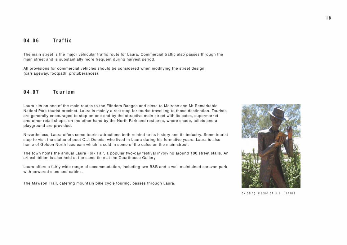
Nevertheless, Laura offers some tourist attractions both related to its history and its industry. Some tourist stop to visit the statue of poet C.J. Dennis, who lived in Laura during his formative years. Laura is also home of Golden North Icecream which is sold in some of the cafes on the main street.
The town hosts the annual Laura Folk Fair, a popular two-day festival involving around 100 street stalls. An art exhibition is also held at the same time at the Courthouse Gallery.
Laura offers a fairly wide range of accommodation, including two B&B and a well maintained caravan park, with powered sites and cabins.
The Mawson Trail, catering mountain bike cycle touring, passes through Laura.
1 8
NOAC01_Laura UDF DraftDRAFT ISSUE
0 1
0 2
0 3
0 4 inventory
0 5
0 6
0 7
0 8
A p
0 4 . 0 8 C o m m e r c i a l A c t i v i t y
The town includes a number of commercial and retail facilit ies. The supermarket, hardware store and other retail outlets service the town population and the surrounding areas. The largest industry is the Golden North Ice-cream factory employing 60 people and currently expanding.
The retail services in Laura are currently above capacity, with the size of retail facilit ies larger than what expected considering the number of inhabitants and other users from surrounding areas. Local support is needed for these facilit ies to survive.
Nevertheless, looking at a future town growth, there is some potential within the main street for future retail/commercial expansion as there are some buildings such as the C.F.S. sheds and the R.S.L. building which could be removed or relocated to a more appropriate area.
0 4 . 0 9 C u r r e n t P r o j e c t s
Laura is currently serviced by a Community Wastewater Management Scheme (CWMS). Northern Areas Council has recently commissioned a new Stormwater Managment Plan (designed to mitigate the current flooding issues) with integrated water reuse strategy.
The plan include new underground pipework, trunk drains and pits to part of Herbert Street and to the whole Hughes Street.
As part of the Southern Flinders Ranges Cycle Tourism Master Plan (2008), there is a proposed rail trail extension continuining the existing 3km secion of rail trail from the southern side of Laura through to Gladstone township.
The area around the Courthouse Gallery and the Laura Archives has recently been upgraded with new lighting, feature paving and street furniture.
NORTHERN AREA COUNCIL_ LAURA _ URBAN DESIGN FRAMEWORK _ DRAFT _ JAN 2011 1 9

e x t r a c t f r o m W & G S t o r m w a t e r M a n a g m e n t P l a n
2 0

NOAC01_Laura UDF DraftDRAFT ISSUE
0 1
0 2
0 3
0 4 inventory
0 5
0 6
0 7
0 8
A p
e x t r a c t f r o m N O A C d e v e l o p m e n t p l a n w i t h t o w n c e n t r e z o n e a n d r e s i d e n t i a l z o n e a s h i g h l i g h t e d
0 4 . 1 0 E x i s t i n g P l a n n i n g F r a m e w o r k
The Laura requirements regarding development are contained in the Development Plan (Consolidated 25 March 2010). The Development Plan sets the objectives and principles of development control.
Some key principle of development control include:
TOWN CENTRE ZONE
Laura town centre zone should be developed to provide a range of retail, businness, commercial, administrative, tourist, cultural and entertainment facilit ies which will serve the need of the population.
Development should be compatible in scale and style with the existing built form and the buildings of heritage significance.
NORTHERN AREA COUNCIL_ LAURA _ URBAN DESIGN FRAMEWORK _ DRAFT _ JAN 2011 2 1

0 4 . 1 1 E x i s t i n g S e r v i c e s
Street drainage consists primarily of large concrete spoondrains on Herbert Street and Hughes Street and roadside swales on other roads. This has not been found sufficient to avoid ponding at intersection and some flooding. Stormwater discharges to the Rocky River at the southern end of the township.
A waste water treatment facility is located on the Laura Beetaloo Road approximately 2.4 kilometres south west of the centre of Laura.
Street lighting on the main street consists of 6 double lights mounted on stobie poles. Recent upgrade on Herbert street has included 4 heritage-style street lighting in front of the two heritage buildings.
The power line runs along the eastern side of Herbert Street (with crossings to the other side of the street) and along the southern side of Hughes Street.
The Laura Folk Fair, taking place on Hughes Street, is curently suffering from limited electrical services.
Mobile telephone service is not always available within the town. A public telephone is located adjacent the post office.
2 2

NOAC01_Laura UDF DraftDRAFT ISSUE
0 1
0 2
0 3
0 4
0 5swot
0 6
0 7
0 8
A p
0 5 . 0 0 S W O T
0 5 . 0 1 S W O T a n a l y s i s
The following analysis of the place identifies Strengths, Weaknesses, Opportunities and Threats in relation to the town of Laura.
As a way to manage the project, the subject area was analysed both in its entirety and as particular zones. An analysis of the site and its various elements, including its location, form and infrastructure was conducted. The results are summarised in the following table:
Inventory Strengths Weaknesses Opportunities Threats
Populationstable or encreasing population predominance of older population
increase tourism and economic development to support resident population
population decline
active community make the town more attractive for future residents ageing population
Town Location
located on the eastern slopes of the southern Flinders Ranges
considered as secondary destination or ‘transit’ town increase active nature-based tourism
close to both Clare Valley and Melrose (tourist precincts)
opportunity for partnership with neighbouring towns
located on major tourist route
part of Mawson trail
situated on the banks of the Rocky River
close to major centres such as Port Pirie, Port Augusta, Clare
Roadways major road runs through the town centre poor materiality improve quality of pedestrian areas traffic increase, especially heavy
vehicles
tree-lined main street, with wide green median strip poor condition of footpath improve definition of parking areas drainage issues
lack of definition of parking areas provision for cyclists
poor stormwater drainage parking for larger vehicles (buses, caravans)
dust on some road sections improve traffic flow and safety
NORTHERN AREA COUNCIL_ LAURA _ URBAN DESIGN FRAMEWORK _ DRAFT _ JAN 2011 2 3

Inventory Strengths Weaknesses Opportunities Threats
Main Street/Town Centre some significant heritage buildings retail/commercial buildings not all
close together
improve the appearance of the main street and town centre to support longer visitor stays and attract new residents
lack of maintenance of heritage buildings and amenities
mixture of residential and commercial/retail building on main streets
disproportioned scale of one of the retail buildings
enhance the existing heritage/township character minimal development controls
buildings generally are occupied number and size of retail services already above capacity develop civic precinct lack of funding
generally a consistent built form and scale
retail services dependent on number of people and on their use of them develop interpretation some shops closing down because of
lack of local support
main street buildings generally have consistent character and are in good condition
consolidate main street character retail services not being used
well defined town centre upgrade street furniture
number of verandah facades promote local business
number of retail services support retail services (by using them)
Township compact layout lack of aged housing include more acccommodation styles unsympathetic development
defined boundaries low emplyment opportunities, expecially for youger people include additional rest/shaded areas
2 towns - point of differnce
Landscape number of mature trees on Herbert st, Hughes st, Mill st
peppercorn trees along Mill Street and Hughes Street, which are identified as weed
improve median strip & consolidate trees on main street lack of maintenance
significant parkland lack of consistency/planning consolidate trees at town southern enrty
red river gum trees along Rocky River embankment develop parkland belt
develop lookout
Surfaces most roads are sealed poor materiality to pedestrian areas improve pedestrian area surfaces
Lighting unconsistent lighting style replace street lighting vandalism, lack of security
unattractive - poor? lighting style
2 4

NOAC01_Laura UDF DraftDRAFT ISSUE
0 1
0 2
0 3
0 4
0 5swot
0 6
0 7
0 8
A p
Inventory Strengths Weaknesses Opportunities Threats
Signageinconsistent signage style develop signage strategy
unsympathetic signage, over-emphasis on signage as a business generator
excessive number of entry signage at northern entry rationalize signage at northern entry
Services number of sport facilit ies limited public transport include additional recreation facilit ies
l imited activities for youth develop caravan park
unreliable mobile communication reception develop stormwater recycling system
improve drainage system
Events Laura Folk Fair is a very popular, award winning event small duration more cultural events in other times of
the yearageing community organisation members
various art exhibitions + Laura Art Prize fluctuating visitor numbers to support and promote the current
eventslimited infrastructure if events become larger
to use the events as a means of strengthening the town identity
events encourage a high standard of presentation of the town
support the identity of the place
NORTHERN AREA COUNCIL_ LAURA _ URBAN DESIGN FRAMEWORK _ DRAFT _ JAN 2011 2 5

2 6