upper mississippi valley base-metal...
TRANSCRIPT

UNIVERSITY OF WISCONSIN-EXTENSIONGEOLOGICAL AND NATURAL HISTORY SURVEYMeredith E. Ostrom, State Geologist and Director
UPPER MISSISSIPPI VALLEY
BASE-METAL DISTRICT
Prepared for:TWENTY-FOURTH ANNUAL MEETINGINSTITUTE ON LAKE SUPERIOR GEOLOGYUNIVERSITY OF WISCONSIN-MILWAUKEEMILWAUKEE, WISCONSINMAY 9—14, 1978
FIELD TRIPGUIDE BOOK
NUMBER 11978

Field Trip Guide BookNumber 1
University of Wisconsin—ExtensionGEOLOGICAL AND NATURAL HISTORY SURVEY
Meredith E. Ostrom, State Geologist and Director
UPPER MISSISSIPPI VALLEY BASE-METAL DISTRICT(companion volume to Information Circular Number 16)
With contributions by
W. A. Broughton, A. V. Heyl, M. G. Mudrey, Jr., M. E. Ostrom,Rachel K. Paull, Richard A. Paull, and W. S. West
Edited by
M. G. Mudrey, Jr.Geological and Natural History Survey
Prepared for
Twenty-Fourth Annual MeetingINSTITUTE ON LAKE SUPERIOR GEOLOGY
University of Wisconsin, MilwaukeeMilwaukee, Wisconsin
May 9-14, 1978
Richard A. Paull, Chairman, Field Trip CommitteeUniversity of Wisconsin-Milwaukee
Available from the Wisconsin Geological and Natural History Survey,University of Wisconsin—Extension, 1815 University Avenue, Madison,Wisconsin 53706
1978
Field Trip Guide BookNumber 1
University of Wisconsin-ExtensionGEOLOGICAL AND NATURAL HISTORY SURVEY
Meredith E. Ostrom, State Geologist and Director
UPPER MISSISSIPPI VALLEY BASE-METAL DISTRICT(companion volume to Information Circular Number 16)
With contributions by
W. A. Broughton, A. V. Heyl~ M. G. Mudrey, Jr., M. E. Ostrom,Rachel K. paull, Richard A. Paull, and W. S. West
Edited by
M. G. Mudrey, Jr.Geological and Natural History Survey
Prepared for
Twenty-Fourth Annual MeetingINSTITUTE ON LAKE SUPERIOR GEOLOGY
University of Wisconsin, MilwaukeeMilwaukee, Wisconsin
May 9-14, 1978
Richard A. PaUll, Chairman, Field Trip CommitteeUniversity of Wisconsin-Milwaukee
Available from the Wisconsin Geological and Natural History Survey,University of Wisconsin-Extension, 1815 University Avenue, Madison,Wisconsin 53706
1978

Page
INTRODUCTION by M. G. Mudrey, Jr
TUESDAY, MAY 9, 1978
Geologic Road Log for U. S. 151 from Madison, Wisconsin (U. S. 12 and14 junction) to Platteville, Wisconsin (Wisconsin 80 and 81junction) by Richard A. Paull and Rachel K. Paull
Geologic Road Log for Grant County by M. G. Mudrey, Jr., W. A.Broughton, A. V. Heyl, and W. S. West
WEDNESDAY, MAY 10, 1978
Geologic Road Log for Lafayette County by M. G. Mudrey, Jr., W. A.Broughton, A. V. Heyl, and W. S. West
Geologic Road Log for Madison Beltline, 1—90, and 1—94 from Madison,Wisconsin (U. S. 12 and 14 junction with U. S. 18 and 151) toMilwaukee, Wisconsin (1—94 junction with 1—43 and 1-794) byRachel K. Paull and Richard A. Paull
GEX)LOGICAL SlOP DESCRIPTIONS
Stop 1 — Hoadley Hill by M. E. OstromStop 2 — Section 2 Quarry by M. G. Mudrey, JrStop 3 — Potosi Hill by M. E. OstromStop 4 - St. John Mine by M. G. Mudrey, JrStop 5 — Shullsburg Mine by Staff, Eagle—Picher Industries
(not attached to road log)
Figure 1.
Figure 2.Figure 3.
Figure 4.
Figure 5.Figure 6.Figure 7.Figure 8.Figure 9.Figure 10.Figure 11.
Map of main part of Upper Mississippi Valley zinc—leaddistrict 2
Highway map showing route of field trip 3
Detailed stratigraphic column of Platteville, Decorah, andGalena formations in zinc—lead district 4
Simplified stratigraphic column showing relative quantitativestratigraphic distribution of zinc and lead in Wisconsin. . . 5
Stalactites in Cave of the Mounds near Blue Mounds 9
Cross section through Blue Mounds from west to east 10
Blue Mound viewed from west 11
Photograph of glacial deposits of southeast Wisconsin . . . . 18Glacially polished Precambrian Waterloo Quartzite 20
Intensively farmed drumlin near Sullivan 22
Scenic overview of the southern Kettle Interlobate Moraine. . 23
:i.
CONTENTS
7
14
16
17
28...32. . . 33
37
ILLUSTRATIONS
OONTENTS
INTRODUCTION by M. G. Mudrey, Jr. • • • • • • • . • • • • • • . • • • • • 1
TUESDAY, MAY 9, 1978
Geologic Road Log for U. S. 151 from Madison, Wisconsin (U. S. 12 and14 junction) to Platteville, Wisconsin (Wisconsin 80 and 81junction) by Richard A. Paull and Rachel K. Paull • • • • • 7
• Geologic Road Log for Grant County by M. G. Mudrey, Jr., W. A.Broughton, A. V. Heyl, and W. S. West • • • • • • • • 14
WEDNESDAY, MAY 10, 1978
Geologic Road Log for Lafayette County by M. G. Mudrey, Jr., W. A.Broughton, A. V. Heyl, and W. S. West .•••••••••••••• 16
Geologic Road Log for Madison Beltline, 1-90, and 1-94 from Madison,Wisconsin (U. S. 12 and 14 junction with U. S. 18 and 151) toMilwaukee, Wisconsin (1-94 junction with 1-43 and 1-794) byRachel K. Paull and Richard A. Paull •••.•••.•••••••• 17
GFXHl>GICAL S1UP DESCRIPTIONS
Stop 1 - Hoadley Hill by M. E. Ostrom • • • • •Stop 2 - Section 2 Quarry by M. G. Mudrey, Jr .•Stop 3 - Potosi Hill by M. E. Ostrom. • . • • •Stop 4 - St. John Mine by M. G. Mudrey, Jr .••Stop 5 - Shullsburg Mine by Staff, Eagle-Picher
(not attached to road log)
ILLUSTRATIONS
Industries
28323337
Figure 1.
Figure 2.Figure 3.
Figure 4.
Figure 5.Figure 6.Figure 7.Figure 8.Figure 9.Figure 10.Figure 11.
Map of main part of Upper Mississippi Valley zinc-leaddistrict. . . . . . . . . . . . . . . . . . . . . 2Highway map showing route of field trip • • . • • • • • 3Detailed stratigraphic column of Platteville, Decorah, andGalena formations in zinc-lead district • . • • • • • • • • • 4Simplified stratigraphic column showing relative quantitativestratigraphic distribution of zinc and lead in Wisconsin. 5Stalactites in Cave of the Mounds near Blue Mounds. • 9Cross section through Blue Mounds from west to east • • 10Blue Mound viewed from west • • • • • • • • • • . • • • • • • 11Photograph of glacial deposits of southeast Wisconsin • 18Glacially polished Precambrian Waterloo Quartzite . • • 20Intensively farmed drumlin near Sullivan••.•.•••••• 22Scenic overview of the southern Kettle Interlobate Moraine •• 23
i

I NTRODUCT ION
M. G. Mudrey, Jr.'
The zinc and lead mines of southwestern Wisconsin are part of the oldestcontinuously producing zinc-lead mining district in the United States, theUpper Mississippi Valley District. The largest and most productive parts ofthis district extend across five Wisconsin counties and into small areas inIllinois and Iowa (Fig. 1). Over 1.2 million tons of zinc and nearly 100,000tons of lead have been recovered from the Wisconsin portion of the Upper Miss-issippi Valley district from 1910 to 1974, with a combined value in excess of$267 million. Heyl and others (1959) suggest that an additional 250,000 tonsof zinc and 350,000 to 400,000 tons of lead were produced in the Wisconsin partof the district in the period following 1800. The text that accompanies thisfield trip (Heyl and others, 1970) covers the early history of the region, andthe geologic controls on ore mineralization. In addition, West and Weeks (1976)provide additional information on the district and its production.
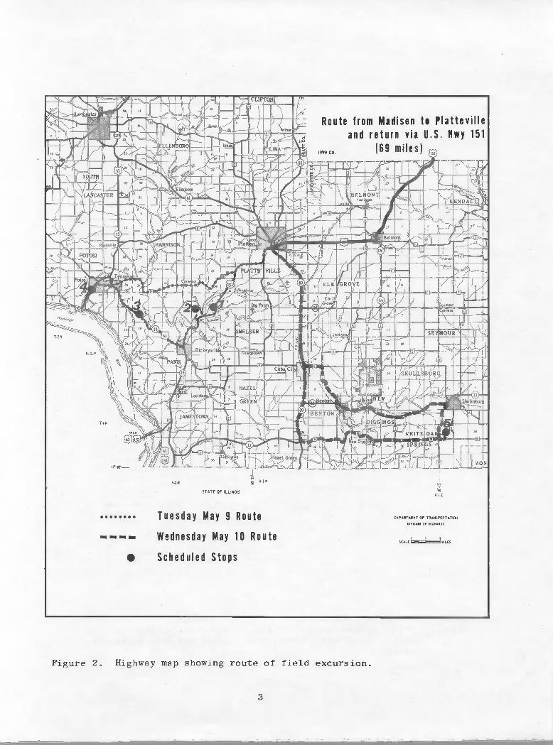
The field trip commences in Madison, proceeds to Platteville for an over-night stop, examines the formations directly related to the ore horizons, andvisits an historic lead mine (St. John Mine) and an operating zinc-lead minenear Shullsburg (Fig. 2). The field trip returns to Madison where privatevehicles can be picked up, and terminates in downtown Milwaukee prior to the25th Annual Institute on Lake Superior Geology.
Geologic stops will be in the Dickeyville, Potosi and Shullsburg 7.5-minute topographic quadrangles. In addition, the route leads through thePlatteville, Cuba City, and New Diggings 7.5-minute topographic quadrangles.Geologic quadrangle references are Cuba City, Agnew (1963); Dickeyville, Whitlowand West (l966a); New Diggings, Mullens (1964); Potosi, Whitlow and West (l966b);and Shullsburg, Mullens (1964).
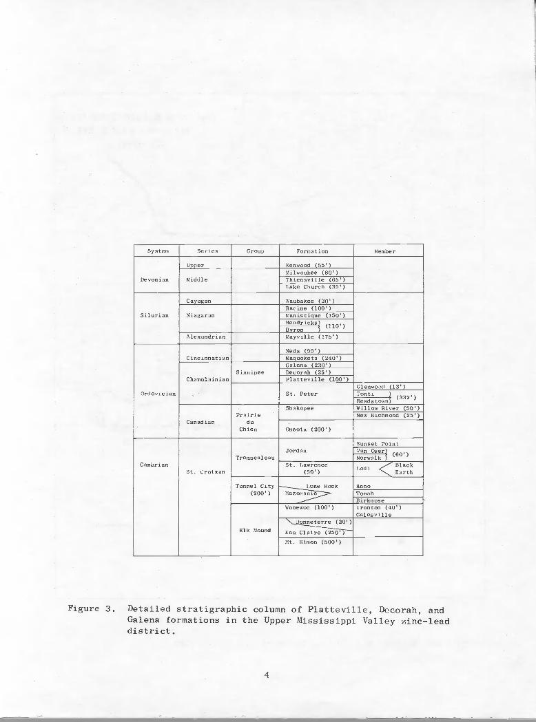
The trip starts with two road cuts and a quarry that include units of theSinnipee Group (Figs. 3 and 4). The first day ends with a visit to an earlylead mine (St. John Mine), that may well have been the first operating mine inWisconsin. The second day the Shullsburg Mine of Eagle Picher Industries, Inc.will be visited. After a lunch stop in Shullsburg, the route leads back toPlatteville via a cultural tour along back roads, and then returns to Madisonand Milwaukee.
This year marks the 125th anniversary of the first Wisconsin geologicalsurvey. Under an act of the Legislature approved March 25, 1853, a StateGeological Survey was created, with an annual appropriation of $2,500 per yearfor four years. Edward Daniels was appointed State Geologist by GovernorLeonard J. Farwell. Daniels' instructions were to "complete his survey of thatportion of the state known as the 'lead mines' before commencing the survey ofthe remainder of the state."
We welcome you to the Zinc-Lead District, and hope that you find the geology,companionship, and tour rewarding!
1 Wisconsin Geological and Natural History Survey, Madison
1
INTRODUCTION
1M. G. Mudrey, Jr.
The zinc and lead mines of southwestern Wisconsin are part of the oldestcontinuously producing zinc-lead mining district in the United States, theUpper Mississippi Valley District. The largest and most productive parts ofthis district extend across five Wisconsin counties and into small areas inIllinois and Iowa (Fig. 1). Over 1.2 million tons of zinc and nearly 100,000
tons of lead have been recovered from the Wisconsin portion of the Upper Mississippi Valley district from 1910 to 1974, with a combined value in excess of$267 million. Heyl and others (1959) suggest that an additional 250,000 tonsof zinc and 350,000 to 400,000 tons of lead were produced in the Wisconsin partof the district in the period following 1800. The text that accompanies thisfield trip (Heyl and others, 1970) covers the early history of the region, andthe geologic controls on ore mineralization. In addition, West and Weeks (1976)provide additional information on the district and its production.
The field trip commences in Madison, proceeds to Platteville for an overnight stop, examines the formations directly related to the ore horizons, andvisits an historic lead mine (St. John Mine) and an operating zinc-lead minenear Shullsburg (Fig. 2). The field trip returns to Madison where privatevehicles can be picked up, and terminates in downtown Milwaukee prior to the25th Annual Institute on Lake Superior Geology.
Geologic stops will be in the Dickeyville, Potosi and Shullsburg 7.5minute topographic quadrangles. In addition, the route leads through thePlatteville, Cuba City, and New Diggings 7.5-minute topographic quadrangles.Geologic quadrangle references are Cuba City, Agnew (1963); Dickeyville, Whitlowand West (1966a); New Diggings, Mullens (1964); Potosi, Whitlow and West (1966b);and Shullsburg, Mullens (1964).
The trip starts with two road cuts and a quarry that include units of theSinnipee Group (Figs. 3 and 4). The first day ends with a visit to an earlylead mine (St. John Mine), that may well have been the first operating mine inWisconsin. The second day the Shullsburg Mine of Eagle Picher Industries, Inc.will be visited. After a lunch stop in Shullsburg, the route leads back toPlatteville via a cultural tour along back roads, and then returns to Madisonand Milwaukee.
This year marks the l25th anniversary of the first Wisconsin geologicalsurvey. Under an act of the Legislature approved March 25, 1853, a StateGeological Survey was created, with an annual appropriation of $2,500 per yearfor four years. Edward Daniels was appointed State Geologist by GovernorLeonard J. Farwell. Daniels' instructions were to "complete his survey of thatportion of the state known as the 'lead mines' before commencing the survey ofthe remainder of the state."
We welcome you to the Zinc-Lead District, and hope that you find the geology,companionship, and tour rewarding!
1 Wisconsin Geological and Natural History Survey, Madison
1

EXPLANATION
o 10 20 MilesI I I
I I
o io 20 Kilometres
Pb Lead
Zn Zinc
Cu Copper
Au Silver
Boundary of main part of district
* Mine or prospect in dolomite ofSilurian age
Mine or prospect in Galena, Deco-rah, and Platteville formations
A Mine or prospect in Prairie duChien group
Figure 1. Map of main part of the Upper Mississippi Valley zinc—lead district,
2
DANE
Freepo·rt-Opb
COLUMBIA
Pb Madison
*Pb*
*
~O--~bO---
STEPHENSON
Cu ZnPbOAu
River
SAUK
Pb
*
Belmont• ·Calamine
.Darlington
~...t..-..!?....-...-.- --I-_=-----,:---------j
Pb*
Pb* Cu
RICHLAND
Platteville _
Pb
*
--IOW4 "\ LAFAYETTE
~ • Shullsburg
Dubuque~ WISCONSIN.,~-.- - - -ILLINOiS - -
"ol'ol' .
'-"ol'ol'/ • Galena~.o....DUBUQUE
CRAWFORD
Cu
*
Zn *Pb
Pb
CLAYTON
\
"'" "-ALLAMAKEE )
/
(I'
DELAWARE
o ZnPb 0
JONES
A.Pb
JACKSONPbo
EXPLANATION
CARROLL OGLE
0 10 20 MilesI I II I0 10 20 Kilometres
Pb Lead
Zn Zinc
Cu Copper
*
o
Mine or prospect in dolomite ofSilurian age
Mine·or prospect in Galena, Decorah, and Platt~ville formations
Au Silver Mine or prospect in Prairie duChien group
Boundary of main part of district
Figure 1. Map of main part of the Upper Mississippi Valley zinc-lead district.
2
1HRRII
'-
\V F:—
TN L
)Jf Jj' 1
iH?E HHHr
Route from Madison t. Plattevilleand return via U.S. Hwy 151
(69 miles)
NL Pii -- \
'I
lmH fl0
\ (ELMONLAIi
F- -_=i__S -4=4
--S 'ELKVE
/L J
)JTF I-, t '— 17 1-i-tI - —
- / oi I
—
/11/ (Ii k-2T'1JL/ ,/r -
O(k S—f— 1ff /)SHUL/UR
-7Lj
ENONç
R-2•W
7L ij 1kWHITEII
hul Isburg
j MON
RI-N
F-
STATE OF ILLINOIS
Tuesday May 9 Route
Wednesday May 10 Route
I Scheduled Stops
R.2E
DEPARTMENT OF TRANSPORTATION
SCALE? MILES
Figure 2. Highway map showing route of field excursion.
3
........----
•
STATE OF ILUNOIS
Tuesday May 9 Route
Wednesday May 10 Route
Scheduled Stops
DEPARTMENT Of TRANSPORTATIClHD1VI~0t4 O' MIG"",AYS
. ,SCALE .1Lf:S
Figure 2. Highway map showing route of field excursion.
3
System Series Group Formation Member
Devonian
Upper Kenwood (55')
MiddleMilwaukee (80')Thiensville (65')Lake Church (35')
Silurian
Cayugan Waubakee (30')
NiagaranRacine (100')Manistique (150')I1endricks
(110')Byron
Alexandrian Mayville (175')
Ordovician
CincinnatianNeda (55')Maquoketa (240')
ChamplainiaoSinnipee
Galena (230')Decorah (25')Platteville (100')
St. PeterGlenwood (13')Tonti
332')Readst own
CanadianPrairie
duChien
Shakopee Willow River (50')New Richmond (25')
Oneota (200')
Cambrian.St. Croixan
TrempealeauJordan
Sunset PointVan Oser
(60')NorwalkSt. Lawrence
(50 )
.- BlackLoch <-. Earth
Tunnel City(200')
Lone RockMazomanie
RenoTomahBirkmose
Elk Mound
Wonewoc (100') Ironton (40')Galesville
Bonneterre (20')
Eau Claire (250')
Mt. Simon (500')
Figure 3. Detailed stratigraphic column of Platteville, Decorah, andGalena formations in the Upper Mississippi Valley zinc—leaddistrict.
4
Figure 3.
System Series Group Formation Member
Unner Kenwood (55' \Milwaukee (80')
Devonian Middle Thiensville (65')Lake Church (35' )
Cayugan Waubakee (30')Racine (100' )
Silurian Niagaran Manistique (l50' )Hendricks)
(1l0' )Bvron
Alexandrian Mayville (175' )
Neda (55')Cincinnatian Maquoketa (240' )
Galena 230'Sinnipee Decorah (25')
Champlainian Platteville (lOO' )Glenwood (13' )
Ordovician St. Peter Tonti )(332' )
ReadstownShakopee Willow River (50' )
Prairie New Richmond (25')Canadian du
Chien Oneota (200' )
Sunset PointJordan Van Oser)
(60')Trempealeau Norwalk j
Cambrian St. LawrenceLodi <Black
St. Croixan (50' ) Earth
Tunnel City Lone Rock Reno(200' ) Maz~ Tomah
BirkmoseWonewoc (100' ) Ironton (40')
Galesville~onneterre (20')
Elk Mound Eau Claire (250')-
Mt. Simon (500')
Detailed stratigraphic column of Platteville, Decorah, andGalena formations in the Upper Mississippi Valley zinc-leaddistrict.
4

Figure 4. Simplified stratigraphic column showing relative quantitativestratigraphic distribution of zinc and lead in the Wisconsin
district.
5
7001050
III
__J
55 75
70330
~o l
40 ~
440780
105
Description
Sandstone
Siltstone and sandstone
Sandstone
Dolomite. drab to butt: cherty; Rrclpta.cutiU.near base
Shale, blue. dolomitiC: phosphatic depauperatefauna <1t base
Sandstone and Siltstone. glaucoroitlc
280-
Dolomite, Iight·buff, cherty; sandy near base and 0- 320
~:~~.~:,,~:".~".~.~.' -f". II ---~
110· 140 I
limestone and doIOI'T"te. brown and grayish: green,sandy shale and phosphatic nO(lules at base
DolomIte. yellowlsh·buff. thln·bedded, snaly_ I 40
Dolomite. yellowlsh.buff, thiCk. bedded :.Rt. f!ptucullt1!S 80In middle 225
Dolomite, buH, cherty; Ptllt4mtru, at lop,
Sandstone. quartz, coarse. rounded.,f------- D1SCONF'ORMITV------f---I
Averagethickness. I
In feet_I90 I
fLjP-=A--o-o,-om-,-..-.-"-11-.-oh-'-ff'-;-'-"-i1-,,-,,-o,-,-n-.-,,-,-,-,.---t-I-I-jO 200 I
108=l
Mount Simonsandstone
Galena dolomite
St. Peter sandstoneDISCONFORMITY
Dresbach sandstone
Trempealeauformation
FranconIa sandstone
Eau Clai,e sandstone
Prairie du ChIen grouplundifferentlated)
f.------l';;:±8------------
~ Maquoketa shale
I Known]E •relative CIl I ~ G roup or
Quantities t;, Q) formation
-1:<;0 _-'-';~- i~I'~• ' 0( ~~; I
~ ~~~
Figure 4. Simplified stratigraphic column shOWing relative quantitativestratigraphic distribution of zinc and lead in the Wisconsindistrict.
5

References Cited
Agnew, A.F., 1963, Geology of the Platteville quadrangle Wisconsin:U.S. Geol. Survey Bull. l123—E, p. 245—277.
Heyl, A.V., Jr., Agnew, A.F., Lyons, E.J., and Behre, C.H., Jr., 1959,The Geology of the Upper Mississippi Valley Zinc—Lead District:U.S. Geol. Survey Prof. Paper 309, 310 p.
Heyl, Ay., Jr., Broughton, W.A., and West, W.S.,, 1970, Guidebook to theUpper Mississippi Valley base metal district: Wisconsin Geol. andNat. History Survey Inf. Circ. No. 16, 49 p.
Mullens, T.E., 1964, Geology of the Cuba City, New Diggings, and Shullsburgquadrangles, Wisconsin and Illinois: U.S. Geol. Survey Bull. 1123-H,p. 437—531.
West, W.S. and Weeks, R.A., 1976, Zinc and Lead in C.E. Dutton, ed.,Mineral and Water Resources of Wisconsin: Report prepared by theU.S. Geol. Survey in collaboration with the Wisconsin Geol. and Nat.History Survey for the Committee on Interior and Insular Affairs,United States Senate, p. 132—145.
Whitlow, J.W., and West, W.S., l966a, Geologic map of the Dickeyvillequadrangle, Grant County, Wisconsin: U.S. Geol. Survey Map GQ-488.
Whitlow, J.W., and West, W.S., 1966b, Geology of the Potosi quadrangle,Grant County, Wisconsin, and Dubuque County, Iowa: U.S. Geol. SurveyBull. 1123—I, p. 533—571.
6
References Cited
Agnew, A.F., 1963, Geology of the Platteville quadrangle Wisconsin:U.S. Geol. Survey Bull. 1123-E, p. 245-277.
Heyl, A.V., Jr., Agnew, A.F., Lyons, E.J., and Behre, C.H., Jr., 1959,The Geology of the Upper Mississippi valley Zinc-Lead District:U.S. Geol. Survey Prof. Paper 309, 310 p.
Heyl, A.V., Jr., Broughton, W.A., and West, W.S., 1970, Guidebook to theUpper Mississippi valley base metal district: Wisconsin Geol. andNat. History Survey Inf. Circ. No. 16, 49 p.
Mullens, T.E., 1964, Geology of the Cuba City, New Diggings, and Shullsburgquadrangles, Wisconsin and Illinois: U.S. Geol. Survey Bull. 1123-H,p. 437-531.
West, W.S. and Weeks, R.A., 1976, Zinc and Lead in C.E. Dutton, ed.,Mineral and Water Resources of Wisconsin: Report prepared by theU.S. Geol. Survey in collaboration with the Wisconsin Geol. and Nat.History Survey for the Committee on Interior and Insular Affairs,United States Senate, p. 132-145.
Whitlow, J.W., and West, W.S., 1966a, Geologic map of the Dickeyvillequadrangle, Grant County, Wisconsin: U.S. Geol. Survey Map GQ-488.
Whitlow, J.W., and West, W.S., 1966b, Geology of the Potosi quadrangle,Grant County, Wisconsin, and Dubuque County, Iowa: U.S. Geol. SurveyBull. 1123-1, p. 533-571. I
6

Tuesday, May 9, 1978
Geologic Road Log for U.S. 151 from Madison, Wisconsin (U.S. 12 an 14 junction)to Platteville, Wisconsin (Wisconsin 80 and 81 junction)
1 2Richard A. Paull and Rachel K. Paull
U.S. 151 from Madison to Verona traverses a recently glaciated (Woodfordian)part of the Eastern Ridges and Lowlands physical province. Since the drift inthis area was deposited near the ice margin, it is generally thin, and theunderlying bedrock exerts considerable influence on the character of the land-scape. From the western edge of the Wisconsinan (Woodfordian) terminal morainejust west of Vernoa to the Sugar River, the route crosses a thin sliver of older(Illinoian) drift. The remainder of the route lies within the classic DriftlessArea of the Western Uplands physical province.
Between Madison and Mt. Horeb, rock exposures along the highway are mainlydolomite assigned to the Lower Ordovician Prairie du Chien Group. However,some younger rocks are also present. The bedrock from Mt. Horeb to Plattevilleis predominantly Middle Ordovician limestone and dolomite of the Platteville,Decorah, and Galena formations, although the Middle Ordovician St. Peter Sandstoneis also exposed along the highway in a few places. Several isolated mounds(outliers) of Upper Ordovician Maquoketa Shale capped by resistant, Siluriandolomite are present near U.S. 151 in the vicinity of Blue Mounds and Platteville.
Mileages
0 (69) Junction U.S. 151 and 18 with U.S. 12 and 14 on the southwestedge of Madison, Wisconsin. Note: The road log from Madisonto Milwaukee provided for Wednesday May 10, 1978 also beginsat this intersection.
1.5 (67.5) Gravel pits to the southeast are in glacial outwash that fillsa preglacial bedrock valley.
2.5 (66.5) Rock exposures along the valley sides are red and yellowweathering St. Peter Sandstone capped by Middle OrdovicianPlatteville-Galena dolomite.
8 (61) Verona, Wisconsin and junction with Wisconsin 69. The thindrift cover here was deposited near the margin of the Wood—fordian ice.
9 (60) Cross the Johnstown Moraine, the terminal moraine of Wisconsinan(Woodfordian) glaciation in this area.
*This road log is published with permission of Kendall/Hunt Publishing Co.,Dubuque, Iowa and it should not be duplicated by any means without writtenpermission.
1 The University of WisconsIn—Milwaukee
2 The University of Wisconsin-Madison and Alverno College, Milwaukee
7
Tuesday, May 9, 1978
Geologic Road Log for U.S. 151 from Madison, Wisconsin (U.S. 12 and 14 junction)to platteville, Wisconsin (Wisconsin 80 and 81 jUnction)*
1 2Richard A. Paull and Rachel K. Paull
U.S. 151 from Madison to Verona traverses a recently glaciated (Woodfordian)part of the Eastern Ridges and Lowlands physical province. Since the drift inthis area was deposited near the ice margin, it is generally thin, and theunderlying bedrock exerts considerable influence on the character of the landscape. From the western edge of the Wisconsinan (Woodfordian) terminal morainejust west of Vernoa to the Sugar River, the route crosses a thin sliver of older(Illinoian) drift. The remainder of the route lies within the classic DriftlessArea of the Western Uplands physical province.
Between Madison and Mt. Horeb, rock exposures along the highway are mainlydolomite assigned to the Lower Ordovician Prairie du Chien Group. However,some younger rocks are also present. The bedrock from Mt. Horeb to Plattevil1eis predominantly Middle Ordovician limestone and dolomite of the Platteville,Decorah, and Galena formations, although the Middle Ordovician St. Peter Sandstoneis also exposed along the highway in a few places. Several isolated mounds(outliers) of Upper Ordovician Maquoketa Shale capped by resistant, Siluriandolomite are present near U.S. 151 in the vicinity of Blue Mounds and Platteville.
Mileages
o (69)
1.5 (67.5)
2.5 (66.5)
8 (61)
9 (60)
Junction U.S. 151 and 18 with U.S. 12 and 14 on the southwestedge of Madison, Wisconsin. Note: The road log from Madisonto Milwaukee provided for Wednesday May 10, 1978 also beginsat this intersection.
Gravel pits to the southeast are in glacial outwash that fillsa preglacial bedrock valley.
Rock exposures along the valley sides are red and yellowweathering St. Peter Sandstone capped by Middle OrdovicianPlatteville-Galena dolomite.
Verona, Wisconsin and junction with Wisconsin 69. The thindrift cover here was deposited near the margin of the Woodfordian ice.
Cross the Johnstown Moraine, the terminal moraine of Wisconsinan(Woodfordian) glaciation in this area.
*This road log is pUblished with permission of Kendall/Hunt Publishing Co.,Dubuque, Iowa and it should not be duplicated by any means without writtenpermission.
1 The University of Wisconsin-Milwaukee
2 The University of Wisconsin-Madison and Alverno College, Milwaukee
7
Mileages
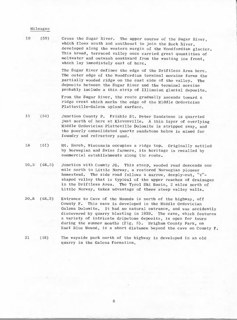
10 (59) Cross the Sugar River. The upper course of the Sugar River,which flows south and southeast to join the Rock River,developed along the western margin of the Woodfordian glacier.This broad, terraced valley once carried great quantities ofmeltwater and outwash southward from the wasting ice front,which lay immediately east of here.
The Sugar River defines the edge of the Driftiess Area here.The outer edge of the Woodfordian terminal moraine forms thepartially wooded ridge on the east side of the valley. Thedeposits between the Sugar River and the terminal moraineprobably include a thin strip of Illinolan glacial deposits.
From the Sugar River, the route gradually ascends toward aridge crest which marks the edge of the Middle OrdovicianPlatteville-Galena upland surface.
15 (54) Junction County P. Friable St. Peter Sandstone is quarriedjust north of here at Kievenville. A thin layer of overlyingMiddle Ordovician Platteville Dolomite is stripped away, andthe poorly consolidated quartz sandstone below is mined forfoundry and refractory sand.
18 (51) Mt. Horeb, Wisconsin occupies a ridge top. Originally settledby Norwegian and Swiss farmers, its heritage is recalled bycommercial establishments along the route.
20.5 (48.5) Junction with County JG. This steep, wooded road descends onemile north to Little Norway, a restored Norwegian pioneerhomestead. The side road follows a narrow, deeply—cut, ttV?ishaped valley that is typical of the upper reaches of drainagesin the Driftless Area. The Tyrol Ski Basin, 2 miles north ofLittle Norway, takes advantage of these steep valley walls.
20.8 (48.2) Entrance to Cave of the Mounds is north of the highway, offCounty F. This cave is developed in the Middle OrdovicianGalena Dolomite. It had no natural entrance, and was accidentlydiscovered by quarry blasting in 1939. The cave, which featuresa variety of intricate dripstone deposits, is open for toursduring the summer months (Fig. 5). Brigham County Park, onEast Blue Mound, is a short distance beyond the cave on County F.
21 (48) The wayside park north of the highway is developed in an oldquarry in the Galena Formation.
8
Mileages
10 (59) Cross the Sugar River. The upper course of the Sugar River,which flows south and southeast to join the Rock River,developed along the western margin of the Woodfordian glacier.This broad, terraced valley once carried great quantities ofmeltwater and outwash southward from the wasting ice front,which lay immediately east of here.
The Sugar River defines the edge of the Driftless Area here.The outer edge of the Woodfordian terminal moraine forms thepartially wooded ridge on the east side of the valley. Thedeposits between the Sugar River and the terminal moraineprobably include a thin strip of Illinoian glacial deposits.
From the Sugar River, the route gradually ascends toward aridge crest which marks the edge of the Middle OrdovicianPlatteville-Galena upland surface.
15 (54)
18 (51)
20.5 (48.5)
20.8 (48.2)
21 (48)
Junction County P. Friable St. Peter Sandstone is quarriedjust north of here at Klevenville. A thin layer of overlyingMiddle Ordovician Platteville Dolomite is stripped away, andthe poorly consolidated quartz sandstone below is mined forfoundry and refractory sand.
Mt. Horeb, Wisconsin occupies a ridge top. Originally settledby Norwegian and Swiss farmers, its heritage is recalled bycommercial establishments along the route.
Junction with County JG. This steep, wooded road descends onemile north to Little Norway, a restored Norwegian pioneerhomestead. The side road follows a narrow, deeply-cut, "V"shaped valley that is typical of the upper reaches of drainagesin the Driftless Area. The Tyrol Ski Basin, 2 miles north ofLittle Norway, takes advantage of these steep valley walls.
Entrance to Cave of the Mounds is north of the highway, offCounty F. This cave is developed in the Middle OrdovicianGalena Dolomite. It had no natural entrance, and was accidentlydiscovered by quarry blasting in 1939. The cave, which featuresa variety of intricate dripstone deposits, is open for toursduring the summer months (Fig. 5). Brigham County Park, onEast Blue Mound, is a short distance beyond the cave on County F.
The wayside park north of the highway is developed in an oldquarry in the Galena Formation.
8

Dripping stalactites hang from the ceiling of thisnarrow passageway in Cave of the Mounds near BlueMounds, Wisconsin. Photo courtesy of Cave of theMounds.
Mileages
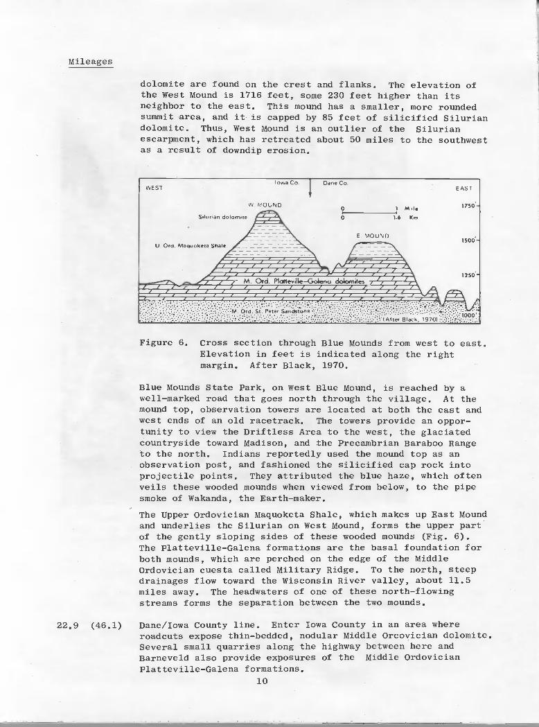
22.7 (46.3) village of Blue Mounds, nestled beneath the west and eastsummits of the Blue Mounds (Fig. 6).
The summits of East and West Blue Mounds are about 1.6 milesapart (Fig. 6). The East Mound, site of Brigham County Park,has a broad flat top developed on the Upper OrdovicianMaquoketa Shale. However a few blocks of silicif led Silurian
9
Figure 5.
Mileages
22.7 (46.3)
Figure 5. Dripping stalactites hang from the ceiling of thisnarrow passageway in Cave of the Mounds near BlueMounds, Wisconsin. Photo courtesy of Cave of theMounds.
Village of Blue Mounds, nestled beneath the west and eastsummits of the Blue Mounds (Fig. 6).
The summits of East and West Blue Mounds are about 1.6 milesapart (Fig. 6). The East Mound, site of Brigham County Park,has a broad flat top developed on the Upper OrdovicianMaquoketa Shale. However a few blocks of silicified Silurian
9
Mileages
dolomite are found on the crest and flanks. The elevation ofthe West Mound is 1716 feet, some 230 feet higher than itsneighbor to the east. This mound has a smaller, more roundedsummit area, and it is capped by 85 feet of silicif led Siluriandolomite. Thus, West Mound is an outlier of the Silurianescarpment, which has retreated about 50 miles to the southwestas a result of downdip erosion.
Cross section through Blue Mounds from west to east.Elevation in feet is indicated along the rightmargin. After Black, 1970.
Blue Mounds State Park, on West Blue Mound, is reached by awell—marked road that goes north through the village. At themound top, observation towers are located at both the east andwest ends of an old racetrack. The towers provide an oppor-tunity to view the Driftless Area to the west, the glaciatedcountryside toward Madison, and the Precambrian Baraboo Rangeto the north. Indians reportedly used the mound top as anobservation post, and fashioned the silicif led cap rock intoprojectile points. They attributed the blue haze, which oftenveils these wooded mounds when viewed from below, to the pipesmoke of Wakanda, the Earth—maker.
The Upper Ordovician Maquoketa Shale, which makes up East Moundand underlies the Silurian on West Mound, forms the upper partof the gently sloping sides of these wooded mounds (Fig. 6).The Platteville—Galena formations are the basal foundation forboth mounds, which are perched on the edge of the MiddleOrdoviclan cuesta called Military Ridge. To the north, steepdrainages flow toward the Wisconsin River valley, about 11.5miles away. The headwaters of one of these north-flowingstreams forms the separation between the two mounds.
22.9 (46.1) Dane/Iowa County line. Enter Iowa County in an area whereroadcuts expose thin—bedded, nodular Middle Orcovician dolomite.Several small quarries along the highway between here andBarneveld also provide exposures of the Middle OrdovicianPlatteville—Galena formations.
10
Figure 6.
Mileages
dolomite are found on the crest and flanks. The elevation ofthe West Mound is 1716 feet, some 230 feet higher than itsneighbor to the east. This mound has a smaller, more roundedsummit area, and it is capped by 85 feet of silicified Siluriandolomite. Thus, West Mound is an outlier of the Silurianescarpment, which has retreated about 50 miles to the southwestas a result of downdip erosion.
WEST
Silurian dolomite
U. Ord. Maquoketa Shale
Iowa Co.
W MOUND
Dane Co.
O~I--------il Mil.o 1.6 Km
E. MOUND
EAST
22.9 (46.1)
M. Ord. Plalteville-Goleno dolomites
Figure 6. Cross section through Blue Mounds from west to east.Elevation in feet is indicated along the rightmargin. After Black, 1970.
Blue Mounds State Park, on West Blue Mound, is reached by awell-marked road that goes north through the village. At themound top, observation towers are located at both the east andwest ends of an old racetrack. The towers provide an opportunity to view the Driftless Area to the west, the glaciatedcountryside toward Madison, and the Precambrian Baraboo Rangeto the north. Indians reportedly used the mound top as anobservation post, and fashioned the silicified cap rock intoprojectile points. They attributed the blue haze, which oftenveils these wooded mounds when viewed from below, to the pipesmoke of Wakanda, the Earth-maker.
The Upper Ordovician Maquoketa Shale, which makes up East Moundand underlies the Silurian on West Mound, forms the upper partof the gently sloping sides of these wooded mounds (Fig. 6).The Platteville-Galena formations are the basal foundation forboth mounds, which are perched on the edge of the MiddleOrdovician cuesta called Military Ridge. To the north, steepdrainages flow toward the Wisconsin River valley, about 11.5miles away. The headwaters of one of these north-flowingstreams forms the separation between the two mounds.
Dane/Iowa County line. Enter Iowa County in an area whereroadcuts expose thin-bedded, nodular Middle Orcovician dolomite.Several small quarries along the highway between here andBarneveld also provide exposures of the Middle OrdovicianPlatteville-Galena formations.
10
Mileages
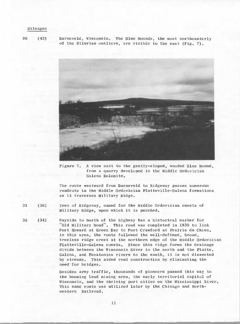
26 (43)
31 (38)
35 (34)
Barneveld, Wisconsin. The Blue Mounds, the most northeasterlyof the Silurian outliers, are visible to the east (Fig. 7).
A view east to the gently—sloped, wooded Blue Mound,from a quarry developed in the Middle OrdovicianGalena Dolomite.
The route westward from Barneveld to Ridgeway passes numerousroadcuts in the Middle Ordovician Platteville-Galena formationsas it traverses Military Ridge.
Town of Ridgeway, named for the Middle Ordovician cuesta ofMilitary Ridge, upon which it is perched.
Wayside to north of the highway has a historical marker for"Old Military Road". This road was completed in 1835 to linkFort Howard at Green Bay to Fort Crawford at Prairie du Chien.In this area, the route followed the well-defined, broad,treeless ridge crest at the northern edge of the Middle OrdovicianPlatteville-Galena cuesta. Since this ridge forms the drainagedivide between the Wisconsin River to the north and the Platte,Galena, and Pecatonica rivers to the south, it is not dissectedby streams. This aided road construction by eliminating theneed for bridges.
Besides army traffic, thousands of pioneers passed this way tothe booming lead mining area, the early territorial capitol ofWisconsin, and the thriving port cities on the Mississippi River.This same route was utilized later by the Chicago and North-western Railroad.
11
Figure 7.
Mileages
26
31
35
(43)
(38)
(34)
Barneveld, Wisconsin. The Blue Mounds, the most northeasterlyof the Silurian outliers, are visible to the east (Fig. 7).
Figure 7. A view east to the gently-sloped, wooded Blue Mound,from a quarry developed in the Middle OrdovicianGalena Dolomite.
The route westward from Barneveld to Ridgeway passes numerousroadcuts in the Middle Ordovician Platteville-Galena formationsas it traverses Military Ridge.
Town of Ridgeway, named for the Middle Ordovician cuesta ofMilitary Ridge, upon which it is perched.
Wayside to north of the highway has a historical marker for"Old Military Road". This road was completed in 1835 to linkFort Howard at Green Bay to Fort Crawford at Prairie du Chien.In this area, the route followed the well-defined, broad,treeless ridge crest at the northern edge of the Middle OrdovicianPlatteville-Galena cuesta. Since this ridge forms the drainagedivide between the Wisconsin River to the north and the Platte,Galena, and Pecatonica rivers to the south, it is not dissectedby streams. This aided road construction by eliminating theneed for bridges.
Besides army traffic, thousands of pioneers passed this way tothe booming lead mining area, the early territorial capitol ofWisconsin, and the thriving port cities on the Mississippi River.This same route was utilized later by the Chicago and Northwestern Railroad.
11

Mileages
39 (30) Junction with U.S. 18 and State 23. U.S. 18, west from here,continues along the route of the historic army road alongMilitary Ridge.
Governor Dodge State Park, located 3 miles north of thisintersection along Wisconsin 23, embraces two lakes formed byimpounding Mill Creek, a tributary to the Wisconsin River.Bedrock exposures in the park include roadcuts through thePlatteville—Galena upland surface, and scenic, natural outcrop—pings of the underlying Middle Ordovician St. Peter Sandstonealong the floor of the valleys.
Turn south on U.S. 151 into Dodgeville, Wisconsin. U.s. 151,from here to Platteville, generally follows an historic cutofffrom the Military Road to the lead mines, and the river portsalong the Mississippi.
395 (29.5) Dodgeville, Wisconsin. The city was named for Henry Dodge, anearly lead miner and Indian fighter in this district. Sincehe was well-liked and an avid supporter of President AndrewJackson, he was appointed as the first territorial governorof Wisconsin in 1836.
43 (26) Silurian outliers of Belmont Mound and Platte Mound are visibleto the southwest, as the highway crosses the rolling, partially-dissected, Middle Ordovician upland surface. Roadcuts provideexposures of Middle Ordovician dolomites along this part of theroute.
47 (22) The historical marker north of the highway commemorates theearly days of Mineral Point.
48 (21) Mineral Point, Wisconsin. This part of the zinc—lead districtwas settled in the l820t5 and 1830's by miners from other miningregions in the U.S., and by Cornish immigrants. A short sidetrip into this historic town, with its narrow, steep streets,is interesting. Here, on Shake Rag Street, the Cornish minersbuilt their small homes from local dolomite along the side ofa narrow valley across from the mines. The street receivedits name because the miners' wives waved dish rags to call themenfolk home when dinner was ready. As a carry—over from thesedays, local restaurants and bakeries still make pasties (meatpies), the traditional, hearty lunch of the Cornish miner.
Part of Shake Rag Street contains a complex of restored Cornishcottages from the 1830's and 1840's, that includes PendarvisHouse. This site is operated by the Wisconsin HistoricalSociety for the public. The Mineral Point Historical Societyhas a museum at Pine and Davis streets that contains excellentmineral samples from local mines.
49 (20) The highway south of Mineral Point follows a narrow ridge thatforms a drainage divide overlooking numerous, small, steep—sidedvalleys on either side.
12
Mileages
39 (30) Junction with U.S. 18 and State 23. U.S. 18, west from here,continues along the route of the historic army road alongMilitary Ridge.
Governor Dodge State Park, located 3 miles north of thisintersection along Wisconsin 23, embraces two lakes formed byimpounding Mill Creek, a tributary to the Wisconsin River.Bedrock exposures in the park include roadcuts through thePlatteville-Galena upland surface, and scenic, natural outcroppings of the underlying Middle Ordovician St. Peter Sandstonealong the floor of the valleys.
Turn south on U.S. 151 into Dodgeville, Wisconsin. U.S. 151,from here to Platteville, generally follows an historic cutofffrom the Military Road to the lead mines, and the river portsalong the Mississippi.
39.5 (29.5)
43 (26)
47 (22)
48 (21)
Dodgeville, Wisconsin. The city was named for Henry Dodge, anearly lead miner and Indian fighter in this district. Sincehe was well-liked and an avid supporter of President AndrewJackson, he was appointed as the first territorial governorof Wisconsin in 1836.
Silurian outliers of Belmont Mound and Platte Mound are visibleto the southwest, as the highway crosses the rolling, partiallydissected, Middle Ordovician upland surface. Roadcuts provideexposures of Middle Ordovician dolomites along this part of theroute.
The historical marker north of the highway commemorates theearly days of Mineral Point.
Mineral Point, Wisconsin. This part of the zinc-lead districtwas settled in the 1820's and 1830's by miners from other miningregions in the U.S., and by Cornish immigrants. A short sidetrip into this historic town, with its narrow, steep streets,is interesting. Here, on Shake Rag Street, the Cornish minersbuilt their small homes from local dolomite along the side ofa narrow valley across from the mines. The street receivedits name because the miners' wives waved dish rags to call themenfolk home when dinner was ready. As a carry-over from thesedays, local restaurants and bakeries still make pas ties (meatpies), the traditional, hearty lunch of the Cornish miner.
Part of Shake Rag Street contains a complex of restored Cornishcottages from the 1830's and 1840's, that includes PendarvisHouse. This site is operated by the Wisconsin HistoricalSociety for the public. The Mineral Point Historical Societyhas a museum at Pine and Davis streets that contains excellentmineral samples from local mines.
49 (20) The highway south of Mineral Point follows a narrow ridge thatforms a drainage divide overlooking numerous, small, steep-sidedvalleys on either side.
12

Mileages
52 (17) The wayside park north of the road provides another view ofPlatte and Belmont Mounds, as the route traverses the dissectedMiddle Ordovician highland surface.
54 (15) Iowa/Lafayette county line. Enter Lafayette County. Withinone mile the highway has crossed Mineral Point Branch and theupper reaches of the Pecatonica River. The valleys formed bythese drainages cut through the Middle Ordovician Platteville-Galena formations into the underlying Middle Ordovician St. PeterSandstone. The contact between these formations is exposed westof the highway near the county line.
61 (8) Enter Belmont, Wisconsin. Roadcuts expose Middle Ordoviciandolomite.
61.5 (7.5) Junction with County G in Belmont. A short side trip along thishighway provides access to two interesting state parks. Threemiles northwest on County G (and B) is First Capitol State Park,the restored site of the first Wisconsin Territorial Capitol in1836. This apparently remote location was in the booming leadmining district, and consequently at the population center ofthis territory when Governor Henry Dodge called the TerritorialLegislature to order. They met here for 46 days in 1836 todevelop a constitution. Eventually Madison, then essentiallyuninhabited and undeveloped, was selected as the permanentcapitol.
Less than a mile east of First Capitol State Park on County Gis Belmont Mound State Park. Here, a scenic parking area islocated on the south side of the mound. This is another Silurianoutlier, as evidenced by abandoned quarry exposures of thin—bedded Lower Silurian dolomite. An observation tower affordsa panoramic view that includes numerous mounds, and the distantedge of the Silurian escarpment to the south and southwest.Both the mounds and the escarpment are capped with resistantSilurian dolomite, and once were part of a continuous bedrocksurface that sloped gently to the southwest. There are severalold lead and zinc mines in this area.
62 (7) Junction of Wisconsin 126 in Belmont. U.S. 151 turns west here.
66 (3) Platte Mound, north of the highway, rises to an elevation of1430 feet. Locally, this wooded hill is called "M" Mound, becauseof the letter formed of white painted stones that is maintainedannually by mining engineering students from the University ofWisconsin—Platteville. This feature, and Little Platte Mound tothe east, are capped by resistant, cherty Lower Silurian dolomite.The nonresistant Upper Ordovician Maquoketa Shale underlies theSilurian (cap rock), and forms the gradual slopes that riseupward from the Middle Ordovician Galena surface. These isolatedhills are remnants (outliers) of an extensive Silurian uplandsurface, which eroded downdip to the southwest. The edge of thishighland is low located in northwestern Illinois and east—central
Iowa.
13
Mileages
52
54
61
(17)
(15)
(8)
The wayside park north of the road provides another view ofPlatte and Belmont Mounds, as the route traverses the dissectedMiddle Ordovician highland surface.
Iowa/Lafayette county line. Enter Lafayette County. Withinone mile the highway has crossed Mineral Point Branch and theupper reaches of the Pecatonica River. The valleys formed bythese drainages cut through the Middle Ordovician PlattevilleGalena formations into the underlying Middle Ordovician St. PeterSandstone. The contact between these formations is exposed westof the highway near the county line.
Enter Belmont, Wisconsin. Roadcuts expose Middle Ordoviciandolomite.
61.5 (7.5) Junction with County G in Belmont. A short side trip along thishighway provides access to two interesting state parks. Threemiles northwest on County G (and B) is First Capitol State Park,the restored site of the first Wisconsin Territorial Capitol in1836. This apparently remote location was in the booming leadmining district, and consequently at the population center ofthis territory when Governor Henry Dodge called the TerritorialLegislature to order. They met here for 46 days in 1836 todevelop a constitution. Eventually Madison, then essentiallyuninhabited and undeveloped, was selected as the permanentcapitol.
Less than a mile east of First Capitol State Park on County Gis Belmont Mound State Park. Here, a scenic parking area islocated on the south side of the mound. This is another Silurianoutlier, as evidenced by abandoned quarry exposures of thinbedded Lower Silurian dolomite. An observation tower affordsa panoramic view that includes numerous mounds, and the distantedge of the Silurian escarpment to the south and southwest.Both the mounds and the escarpment are capped with resistantSilurian dolomite, and once were part of a continuous bedrocksurface that sloped gently to the southwest. There are severalold lead and zinc mines in this area.
62
66
(7)
(3)
Junction of Wisconsin 126 in Belmont. U.S. 151 turns west here.
Platte Mound, north of the highway, rises to an elevation of1430 feet. Locally, this wooded hill is called "M" Mound, becauseof the letter formed of white painted stones that is maintainedannually by mining engineering students from the University ofWisconsin-Platteville. This feature, and Little Platte Mound tothe east, are capped by resistant, cherty Lower Silurian dolomite.The nonresistant Upper Ordovician Maquoketa Shale underlies theSilurian (cap rock), and forms the gradual slopes that riseupward from the Middle Ordovician Galena surface. These isolatedhills are remnants (outliers) of an extensive Silurian uplandsurface, which eroded downdip to the southwest. The edge of thishighland is low located in northwestern Illinois and east-central
Iowa.
13

Mileages
67 (2) Lafayette/Grant county line. Enter Grant County.
69 (0) Enter Platteville and pass a large quarry developed in theMiddle Ordovician Galena Dolomite to the north of the highway.Junction U.S. 151 with Wisconsin 80 and 81.
The University of Wisconsin—Platteville, with its long historyof training mining engineers and geologists, is located in thiscity. The Mining Museum, on Main Street in Platteville, providesan opportunity for tourists to tour uiilerground in the historicBevan lead mine, and to view relics from the early days of thelead rush.
END OF U.S. 151 MADISON—PLATTEVILLE LOG
Geologic Road Log for Grant County
M.G. Mudrey, Jr., W.A. Broughton1'2, A.V. Heyl3, W.S. West3
Continuation of Tuesday, May 9
This leg of the trip visits four localities that illustrate the MiddleOrdovician succession of southwestern Wisconsin, and a tour of a vintage 1830lead mine now operated as a tourist attraction. After the visit to the mine,we will return to Platteville for the evening. Lodging and dinner this eveningare covered by the field trip fee. Individual stop descriptions follow theroad logs.
Mileages
0.0 Governor Dodge Motel. Leave motel and proceed right (southwest)on U.S. 151
6.1 Stop 1 — Hoadley Hill. Excellent exposure of St. Peter,Platteville, and Decorah formations. Continue west on U.S. 151.
7.4 Right turn onto Church Road (gravel).
7.8 Bear left, at Y in road.
8.1 Stop 2 - Section 2 quarry in upper part of Platteville Formationand Decorah Formation. Quimbys Mill Member of Decorah Formationis especially well exposed. Middle Ordovician fossil locality.Turn around at top of hill, and return to U.S. 151. Continuewest on U.S. 151.
1 Wisconsin Geological and Natural History Survey2 Dept. of Geology, IJW—Platteville3 U.S. Geological Survey
14
Mileages
67 (2) Lafayette/Grant county line. Enter Grant County.
69 (0) Enter Platteville and pass a large quarry developed in theMiddle Ordovician Galena Dolomite to the north of the highway.Junction U.S. 151 with Wisconsin 80 and 81.
The University of Wisconsin-Platteville, with its long historyof training mining engineers and geologists, is located in thiscity. The Mining Museum, on Main Street in Platteville, providesan opportunity for tourists to tour underground in the historicBevan lead mine, and to view relics from the early days of thelead rush.
END OF U.S. 151 MADISON-PLATTEVILLE LOG
Geologic Road Log for Grant County
M.G. Mudrey, Jr. l , W.A. Broughtonl ,2, A.V. Hey13, W.S. west3
Continuation of Tuesday, May 9
that illustrate the Middleand a tour of a vintage 1830After the visit to the mine,
Lodging and dinner this eveningstop descriptions follow the
This leg of the trip visits four localitiesOrdovician succession of southwestern Wisconsin,lead mine now operated as a tourist attraction.we will return to Platteville for the evening.are covered by the field trip fee. Individualroad logs.
Mileages
0.0 Governor Dodge Motel. Leave motel and proceed right (southwest)on U.S. 151
Stop 1 - Hoadley Hill. Excellent exposure of St. Peter,Platteville, and Decorah formations. Continue west on U.S. 151.
Right turn onto Church Road (gravel).
7.8 Bear left, at Y in road.
8.1 stop 2 - Section 2 quarry in upper part of Platteville Formationand Decorah Formation. Quimbys Mill Member of Decorah Formationis especially well exposed. Middle Ordovician fossil locality.Turn around at top of hill, and return to U.S. 151. Continuewest on U.S. 151.
1 Wisconsin Geological and Natural History Survey2 Dept. of Geology, UW-Platteville3 U.S. Geological Survey
14
Mileages
11.7 Enter Dickeyville.
12.0 Right turn (north) onto U.S. 61 and State 35.
15.9 Cross Platte River.
16.1 Base of Potosi Hill roadcut.
16.6 Stop 3 - Potosi Hill. Excellent exposure of upper part ofPlatteville Formation, Decorah Shale, axd lower part of theGalena Formation. Continue north on U.S. 61 and State 35.
18.5 Enter Tennyson.
19.1 Turn left (west) on County 0.
19.7 Enter Potosi.
20.3 Stop sign. Proceed straight ahead (south) on State 133.
20.5 Stop 4 - St. John's Mine. Old lead mine from the 1830's.Retrace route to intersection State 133 and County 0.
21.9 Intersection with U.S. 61 and State 35. Continue east onCounty 0.
27.6 Enter Cornelia.
31.5 Junction with U.S. 151. Turn left (north) toward Platteville.
34.7 Governor Dodge Motel.
END OF LOG
15
Mileages
11. 7
12.0
15.9
16.1
18.5
19.1
19.7
20.3
20.5
21.9
27.6
31.5
34.7
Enter Dickeyville.
Right turn (north) onto U.S. 61 and State 35.
Cross Platte River.
Base of Potosi Hill roadcut.
stop 3 - Potosi Hill. Excellent exposure of upper part ofPlatteville Formation, Decorah Shale,an.d lower part of theGalena Formation. Continue north on U.S. 61 and State 35.
Enter Tennyson.
Turn left (west) on County O.
Enter Potosi.
Stop sign. Proceed straight ahead (south) on State 133.
Stop 4 - St. John's Mine. Old lead mine from the 1830's.Retrace route to intersection State 133 and County O.
Intersection with U.S. 61 and State 35. Continue east onCounty O.
Enter Cornelia.
Junction with U.S. 151. Turn left (north) toward Platteville.
Governor Dodge Motel.
END OF LOG
15
Wednesday May 10, 1978
Geologic Road Log for Lafayette County
M.G. Mudrey, Jr.', LA. Broughton1'2, A.V. Heyl3, W.S. West3
This leg of the trip visits the Shullsburg Mine of Eagle-Picher Industries,the only operating zinc—lead mine complex in the Upper Mississippi Valley basemetal district. Participants are reminded to wear appropriate safety equipment;including hard hat, light, self—rescuer, safety boots and glasses.
In the afternoon we will return to Platteville, Madison (where privateautomobiles can be picked up), and Milwaukee. Historical and cultural stopsmay be made en route. We plan to arrive in Milwaukee about 6:00 P.M.
Morning, May 10
Mileages
0.0 Leave Governor Dodge Motel and proceed left (east) on U.S. 151.
0.2 Turn right (south) on State 80 and State 81.
6.8 Buildings and tailings pond of abandoned New Jersey ZincCompany's Elmo Mine can be seen in left distance.
9.4 Enter Cuba City.
9.7 Turn left (east) on County H (best route).
10.9 Junction with County J. Turn right, proceed south on County J.
11.9 Vinegar Hill Acid Plant, closed in 1948, was located south ofroad.
13.6 Enter Benton.
14.0 Join State 11. Turn left (east). Numerous abnadoned minesare along this road.
21.8 Enter Shullsburg.
23.1 Right turn (south) on County 0.
24.7 Tailings area of Eagle-Picher Industries, Inc. Shullsburg Mineon left.
25.1 Left turn (east) on County W.
1 Wisconsin Geological and Natural History Survey2 Dept. of Geology, TJW—Platteville3 U.S. Geological Survey
16
Wednesday May 10, 1978
Geologic Road Log for Lafayette County
d 1 A h 1,2 Hey13, 3M.G. Mu rey, Jr. , W•• Broug ton , A.V. W.S. West
This leg of the trip visits the Shullsburg Mine of Eagle-Picher Industries,the only operating zinc-lead mine complex in the Upper Mississippi Valley basemetal district. Participants are reminded to wear appropriate safety equipment;including hard hat, light, self-rescuer, safety boots and glasses.
In the afternoon we will return to Platteville, Madison (where privateautomobiles can be picked up), and Milwaukee. Historical and cultural stopsmay be made en route. We plan to arrive in Milwaukee about 6:00 P.M.
Morning, May 10
Mileages
0.0
0.2
6.8
10.9
11.9
13.6
14.0
21.8
23.1
24.7
25.1
Leave Governor Dodge Motel and proceed left (east) on U.S. 151.
Turn right (south) on State 80 and State 81.
Buildings and tailings pond of abandoned New Jersey ZincCompany's Elmo Mine can be seen in left distance.
Enter Cuba City.
Turn left (eas~on County H (best route).
Junction with County J. Turn right, proceed south on County J.
Vinegar Hill Acid Plant, closed in 1948, was located south ofroad.
Enter Benton.
Join State 11. Turn left (east). Numerous abnadoned minesare along this road.
Enter Shullsburg.
Right turn (south) on County o.
Tailings area of Eagle-Picher Industries, Inc. Shullsburg Mineon left.
Left turn (east) on County W.
1 Wisconsin Geological and Natural History Survey2 Dept. of Geology, UW-Platteville3 U.S. Geological Survey
16

Mileages
25.8 Left turn (north). Entry to Eagle-Picher property.Stop 5 — Shullsburg Mine. You are reminded to have on hardhat, light, self—rescuer, safety boots, and glasses. Tourmine complex with company geologists.
29.8 About noon; return to Shullsburg for box lunch.
Afternoon, May 10
Scenic return to Platteville. Historical sights en route viaCounty W, include towns of New Diggings, and Hazel Green. Rightturn (north) on State 80 and 11 to Cuba City and Platteville.
57.1 Enter Platteville. Return to Madison. Stop to pick up privateautomobiles. Bus will continue to Milwaukee, arriving about6:00 P.M.
Geologic Road Log for Madison Beitline, 1—90, and 1-94 from Madison,Wisconsin (Junction U.S. 12 and 14 with U.S. 18 and 151) to Milwaukee,
Wisconsin (Junction 1—94 with 1—43 and I_794)*.
Rachel K. Paull' and Richard A. Paull2
This route from Madison to Milwaukee is entirely within the EasternRidges and Lowlands physical province, and it trends at right angles to thegeneral strike of the Paleozoic formations. Consequently, the bedrock alongthe route, although largely obscured by Woodfordian glacial deposits, rangesfrom Upper Cambrian formations on the west to Silurian dolomite on the east.
The glacial geology encountered along 1—94 is spectacular. As shown inFigure 8, the interstate cuts most of these glacial features essentially atright angles. From west to east, these include well-developed drumlin fields,outwash plains, the Kettle Interlobate Moraine with numerous scenic lakes, andrecessional moraines of the Lake Border morainic system. Other significantattractions along this route include: the Lapham Peak overlook high in theKettle Moraine and the subcontinental divide that separates drainage destinedfor the North Atlantic via the St. Lawrence from that which reaches the Gulfof Mexico via the Mississippi.
*This road log is published with permission of Kendall/Hunt Publishing Company,Dubuque, Iowa, and it should not be duplicated by any means without writtenpermission.
1 University of Wisconsin—Madison & Alverno College, Milwaukee
2 University of Wisconsin-Milwaukee
17
Mileages
25.8 LeftStophat,mine
turn (north). Entry5 - Shullsburg Mine.light, self-rescuer,complex with company
to Eagle-Picher property.You are reminded to have on hard
safety boots, and glasses. Tourgeologists.
29.8
57.1
About noon; return to Shullsburg for box lunch.
Afternoon, May 10
Scenic return to Platteville. Historical sights en route viaCounty W, include towns of New Diggings, and Hazel Green. Rightturn (north) on State 80 and 11 to Cuba City and Platteville.
Enter Platteville. Return to Madison. Stop to pick up privateautomobiles. Bus will continue to Milwaukee, arriving about6:00 P.M.
Geologic Road Log for Madison Beltline, 1-90, and 1-94 from Madison,Wisconsin (Junction U.S. 12 and 14 with U.S. 18 and 151) to Milwaukee,
Wisconsin (Junction 1-94 with 1-43 and 1-794)*.
Rachel K. paull l and Richard A. paul12
This route from Madison to Milwaukee is entirely within the EasternRidges and Lowlands physical province, and it trends at right angles to thegeneral strike of the Paleozoic formations. Consequently, the bedrock alongthe route, although largely obscured by Woodfordian glacial deposits, rangesfrom Upper Cambrian formations on the west to Silurian dolomite on the east.
The glacial geology encountered along 1-94 is spectacular. As shown inFigure 8, the interstate cuts most of these glacial features essentially atright angles. From west to east, these include well-developed drumlin fields,outwash plains, the Kettle Interlobate Moraine with numerous scenic lakes, andrecessional moraines of the Lake Border morainic system. Other significantattractions along this route include: the Lapham Peak overlook high in theKettle Moraine and the subcontinental divide that separates drainage destinedfor the North Atlantic via the St. Lawrence from that which reaches the Gulfof Mexico via the Mississippi.
*This road log is pUblished with permission of Kendall/Hunt Publishing Company,Dubuque, Iowa, and it should not be duplicated by any means without writtenpermission.
1 University of Wisconsin-Madison & Alverno College, Milwaukee
2 University of Wisconsin-Milwaukee
17

Mileages
Glacial deposits of southeast Wisconsin, includingglacial lake deposits, the Kettle Interlobate Moraine,drumlin patterns, and the Lake Border morainic system.The Altonian drift shown in Rock and Walworth counties,Wisconsin also includes drift that is older thanWisconsinan. Interstates 94, 43, and 90 are alsoindicated. Generalized from numerous sources,including Thwaites, 1956.
0 (83)
1 (82)
3 (80)
Intersection of U.S. 12 and 14 with U.S. 18 and 151 on thesoutheast edge of Madison, Wisconsin. Turn east on the MadisonBeltline (U.S. 12, 14, 18, and 151). Note: This was thestarting point for the U.S. 151 Madison to Platteville roadguideprovided for Tuesday May 9, 1978.
The wooded tracts on both sides of the highway are parts of the1,240 acre University of Wisconsin Arboretum. Although primarilya research and study area, hikers are permitted on 24 miles offoot trails. This nature preserve extends north from here tothe south shore of Lake Wingra.
Intersection of U.s. 12 and 18 with U.S. 14 and 151. Continueeast on U.S. 12 and 18.
4.5 (78.5) Lake Monona, north of the highway, is the second largest ofMadison's four lakes. These lakes are the result of Pleistoceneerosion and deposition along the Yahara River drainage.
5.5 (77.5) The wooded, irregular ridge visible to the south over the flatoutwash surface is part of the Woodfordian Johnstown-Miltonterminal moraine system.
6.2 (76.8) Cross the Yahara River, which connects Madison's four lakes.The Yahara flows southeasterly to join the Rock River northof Janesville, Wisconsin. The relatively flat land surfacesouth of the highway is probably an outwash deposit (valleytrain) formed during the complex Pleistocene history of theYahara River.
18
Figure 8.
'pm. ~ GLACIAL LAKE DEPOSITS
~----<16km ~~VALDERAN DRIFT
i-T7@;--.---\fij.+:.w 1·... :·.. :·:1 LAKE BORDER MORAINE::...... (WOODFORDIAN)
;:. IT] RECESSIONAL MORAINE
'i rn TERMINAL MORAINEG>~ D WOODFORDIAN DRIFT
R.cine
[l] INTER LOBATE MORAINE
[Z[] DRUMLIN TRENDS
• AL TONIAN DRIFT
IIII r - -++·~4)H+.:f>{I I
L..nG_..... i--- .....II
WALWORTH KENOSHA
1/ f 1\ .........- I
I / I I II ,\ \ I
;'l c•• 3m.1 III ,I
"I 1._......I II II II I I II"UE££E1!..S~ ~
Whit_atr-
Figure 8. Glacial deposits of southeast Wisconsin, includingglacial lake deposits, the Kettle Interlobate Moraine,drumlin patterns, and the Lake Border morainic system.The Altonian drift shown in Rock and Walworth counties,Wisconsin also includes drift that is older thanWisconsinan. Interstates 94, 43, and 90 are alsoindicated. Generalized from numerous sources,including Thwaites, 1956.
Mileages
o (83) Intersection of U.S. 12 and 14 with U.S. 18 and 151 on thesoutheast edge of Madison, Wisconsin. Turn east on the MadisonBeltline (U.S. 12, 14, 18, and 151). Note: This was thestarting point for the U.S. 151 Madison to Platteville roadguideprovided for Tuesday May 9, 1978.
1 (82) The wooded tracts on both sides of the highway are parts of the1,240 acre University of Wisconsin Arboretum. Although primarilya research and study area, hikers are permitted on 24 miles offoot trails. This nature preserve extends north from here tothe south shore of Lake Wingra.
3 (80) Intersection of U.S. 12 and 18 with U.S. 14 and 151. Continueeast on U.S. 12 and 18.
4.5 (78.5) Lake Monona, north of the highway, is the second largest ofMadison's four lakes. These lakes are the result of Pleistoceneerosion and deposition along the Yahara River drainage.
5.5 (77.5) The wooded, irregular ridge visible to the south over the flatoutwash surface is part of the Woodfordian Johnstown-Miltonterminal moraine system.
6.2 (76.8) Cross the Yahara River, which connects Madison's four lakes.The Yahara flows southeasterly to join the Rock River northof Janesville, Wisconsin. The relatively flat land surfacesouth of the highway is probably an outwash deposit (valleytrain) formed during the complex Pleistocene history of theYahara River.
18
Mileages
7.5 (75.5) Junction of U.S. 12, 18, and U.S. 51. Continue east on U.S.12 and 18.
9.2 (73.8) Junction of U.s. 12 and 18 with 1—90. Turn north (left) on 1—90.
12. (71) Interstate 90 traverses rolling, morainal countryside.
13.7 (69.3) Junction of 1—90 with 1—94. Turn east on 1—94 to Milwaukee.
Southeast of this intersection, crushed stone is produced fromtheMiddle Ordovician Platteville Formation. The underlyingSt. Peter Sandstone is also exposed in this quarry.
18 (65) Exit County N to Sun Prairie and Cottage Grove. Well-developeddrumlins, trending southwesterly, rise above rolling groundmoraine, and are cut by the interstate. The irregular, hillyridge on the skyline to the south is the Woodfordian Milton-Johnstown terminal moraine system of the Green Bay lobe.
21 (62) Area of poorly drained, peaty soil in an interdrumlin area.A commercial sod and mint farm is north of the highway.
This region is drained by Koshkonong Creek, which crossesbeneath the interstate at Baxter Road. This stream flows intoLake Koshkonong to the south, after draining a vast, marshy area.
24 (59) Exit Wisconsin 73 to Marshall and Deerfield. Southwest—trendingdrumlins form islands between swamps within the rolling countryside.Just east of this junction, a large number of glacial erraticsare present. These are part of the boulder train derived fromexposures of the Precambrian Waterloo Quartzite northeast of here.
27 (56) Goose Lake and the swamp to the south are remnants of a muchlarger shallow lake that once existed between drumlins in thisarea. Much of the land here has been ditched for drainage, butsome drumlins still rise as wooded islands surrounded by swamps.Fossil remains of a mastodon and a giant beaver dated at 9,000to 10,000 years B.P. were found in shallow peat deposits nearby.
28 (55) Dane/Jefferson county line. Enter Jefferson County, and a spec-tacular array of drumlins. An excellent swarm occurs whereCounty 0 crosses the interstate. The extensively tiered roadcutat the county line provides a transverse section through adrumlin. Erratic boulders are common in the drift in this area.
33 (50) Exit Wisconsin 89 to Lake Mills and Waterloo. The rough countryimmediately west of here consists of pitted outwash betweenpatches of the Lake Mills recessional moraine system. Rock Lake,.25 mile to the southwest, occupies a very large kettle. Thereare also many small ice stagnation features in this area. Mostof these are sandy deposits, some of which lap onto the marginsof drumlins.
19
—
Mileages
7.5 (75.5)
9.2 (73.8)
Junction of U.S. 12, 18, and U.S. 51. Continue east on U.S.12 and 18.
Junction of U.S. 12 and 18 with 1-90. Turn north (left) on 1-90.
12. (71) Interstate 90 traverses rolling, morainal countryside.
13.7 (69.3) Junction of 1-90 with 1-94. Turn east on 1-94 to Milwaukee.
Southeast of this intersection, crushed stone is produced fromtheMiddle Ordovician Platteville Formation. The underlyingSt. Peter Sandstone is also exposed in this quarry.
18
21
24
27
28
33
(65)
(62)
(59)
(56)
(55)
(50)
Exit County N to Sun Prairie and Cottage Grove. Well-developeddrumlins, trending southwesterly, rise above rolling groundmoraine, and are cut by the interstate. The irregular, hillyridge on the skyline to the south is the Woodfordian MiltonJohnstown terminal moraine system of the Green Bay lobe.
Area of poorly drained, peaty soil in an interdrumlin area.A commercial sod and mint farm is north of the highway.
This region is drained by Koshkonong Creek, which crossesbeneath the interstate at Baxter Road. This stream flows intoLake Koshkonong to the south, after draining a vast, marshy area.
Exit Wisconsin 73 to Marshall and Deerfield. Southwest-trendingdrumlins form islands between swamps within the rolling countryside.Just east of this junction, a large number of glacial erraticsare present. These are part of the boulder train derived fromexposures of the Precambrian Waterloo Quartzite northeast of here.
Goose Lake and the swamp to the south are remnants of a muchlarger shallow lake that once existed between drumlins in thisarea. Much of the land here has been ditched for drainage, butsome drumlins still rise as wooded islands surrounded by swamps.Fossil remains of a mastodon and a giant beaver dated at 9,000to 10,000 years B.P. were found in shallow peat deposits nearby.
Dane/Jefferson county line. Enter Jefferson County, and a spectacular array of drumlins. An excellent swarm occurs whereCounty 0 crosses the interstate. The extensively tiered roadcutat the county line provides a transverse section through adrumlin. Erratic boulders are common in the drift in this area.
Exit Wisconsin 89 to Lake Mills and Waterloo. The rough countryimmediately west of here consists of pitted outwash betweenpatches of the Lake Mills recessional moraine system. Rock Lake,.25 mile to the southwest, occupies a very large kettle. Thereare also many small ice stagnation features in this area. Mostof these are sandy deposits, some of which lap onto the marginsof drumlins.
19
Mileages
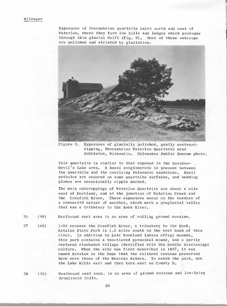
Exposures of Precambrian quartzite exist north and east ofWaterloo, where they form low hills and ledges which protrudethrough thin glacial drift (Fig. 9). Most of these outcropsare polished and striated by glaciation.
This quartzite is similar to that exposed in the Baraboo-Devil's Lake area. A basal conglomerate is present betweenthe quartzite and the overlying Paleozoic sandstone. Smallpotholes are scoured on some quartzite surfaces, and beddingplanes are occasionally ripple marked.
The main outcroppings of Waterloo Quartzite are about a mileeast of Portland, and at the junction of Waterloo Creek andthe Crawfish River. These exposures occur on the borders ofa connect4d series of marshes, which mark a preglacial valleythat was a tributary to the Rock River.
35 (48)
37 (46)
38 (45)
Eastbound rest area in an area of rolling ground moraine.
1-94 crosses the Crawfish River, a tributary to the Rock.Aztalan State Park is 1.5 miles south on the west bank of thisriver. In addition to Late Woodland Indian effigy mounds,this park contains a two-tiered pyramidal mound, and a partlyrestored stockaded village identif led with the Middle Mississippiculture. When the site was first described in 1837, it wasnamed Aztalan in the hope that the cultural remains preservedhere were those of the Mexican Aztecs. To reach the park, usethe Lake Mills exit and then turn east on County B.
Westbound rest area, in an area of ground moraine and low—lyingdrumlinoid hills.
20
Figure 9. Exposures of glacially polished, gently eastward-dipping, Precambrian Waterloo Quartzite nearHubbleton, Wisconsin. Milwaukee Public Museum photo.
Mileages
Exposures of Precambrian quartzite exist north and east ofwaterloo, where they form low hills and ledges which protrudethrough thin glacial drift (Fig. 9). Most of these outcropsare polished and striated by glaciation.
Figure 9. Exposures of glacially polished, gently eastwarddipping, Precambrian Waterloo Quartzite nearHubbleton, Wisconsin. Milwaukee Public Museum photo.
This quartzite is similar to that exposed in the BarabooDevil's Lake area. A basal conglomerate is present betweenthe quartzite and the overlying Paleozoic sandstone. Smallpotholes are scoured on some quartzite surfaces, and beddingplanes are occasionally ripple marked.
The main outcroppings of Waterloo Quartzite are about a mileeast of Portland, and at the junction of Waterloo Creek andthe Crawfish River. These exposures occur on the borders ofa connect4d series of marshes, which mark a preglacial valleythat was a tributary to the Rock River.
35
37
38
(48)
(46)
(45)
Eastbound rest area in an area of rolling ground moraine.
1-94 crosses the Crawfish River, a tributary to the Rock.Aztalan State Park is 1.5 miles south on the west bank of thisriver. In addition to Late Woodland Indian effigy mounds,this park contains a two-tiered pyramidal mound, and a partlyrestored stockaded village identified with the Middle Mississippiculture. When the site was first described in 1837, it wasnamed Aztalan in the hope that the cultural remains preservedhere were those of the Mexican Aztecs. To reach the park, usethe Lake Mills exit and then turn east on County B.
Westbound rest area, in an area of ground moraine and low-lyingdrumlinoid hills.
20

Mileages
39 (44) 1-94 crosses the Rock River. The Rock marks a generalvegetation divide between native hardwood forests to the east,and oak savannas and prairies to the west. Some think theriver formed a barrier to prairie fires, thus preserving theforests on the east.
Jefferson, 6.5 miles to the south at the junction of the Crawfishand Rock rivers, experienced a short—lived, geology-related,land boom about 1840. A federally-assisted project was plannedto construct a canal from Lake Michigan at Milwaukee to theRock River near Jefferson. Some construction was actuallyaccomplished before the million—dollar project was abandoned.Meanwhile, land values had sky—rocketed in Jefferson as theprospect of a connection between the Mississippi River andthe Great Lakes seemed imminent. Land promoters arrived, anda steamboat made it up the Rock River from St. Louis. Tractsof swampland were bought by local residents and newcomers atinflated prices, in the hope that great profits would resultwhen the canal was completed. The land promoters left townwith well—laden carpetbags, before news of the abandonment ofthe canal plans reached southern Wisconsin.
40 (43) Exit Wisconsin 26 to Watertown, Johnson Creek, and Jefferson,within the Jefferson County drumlin field. Where the interstatecuts through a drumlin, the roadcuts have been carefully soddedover to conceal the internal character of the sandy and clayey
till. However, at the northwest corner of this intersection,behind the service station and restaurant, an excavated drumlin
is exposed.
46 (37) Irregular ground moraine assumes symmetry and order as thehighway traverses a classical drumlin field, produced by theGreen Bay lobe of the Woodfordian ice advance (Fig. 10). Thesedrumlins trend essentially north—south in this area, but nearer
to Madison the orientation was southwesterly.
Poorly drained areas and tamarack swamps flank many of thedrumlins in this area.
50 (33) Wisconsin 135 exit.
52 (31) Jefferson/Waukesha county line. Enter Waukesha County. Thedrainage in this rolling countryside is poor, and farm fields
must be ditched. Numerous tamarack swamps with red osierdogwood are lingering evidence of the boreal climate of the
Pleistocene.
21
Mileages
39
40
46
50
52
(44)
(43)
(37)
(33)
(31)
1-94 crosses the Rock River. The Rock marks a generalvegetation divide between native hardwood forests to the east,and oak savannas and prairies to the west. Some think theriver formed a barrier to prairie fires, thus preserving theforests on the east.
Jefferson, 6.5 miles to the south at the junction of the Crawfishand Rock rivers, experienced a short-lived, geology-related,land boom about 1840. A federally-assisted project was plannedto construct a canal from Lake Michigan at Milwaukee to theRock River near Jefferson. Some construction was actuallyaccomplished before the million-dollar project was abandoned.Meanwhile, land values had sky-rocketed in Jefferson as theprospect of a connection between the Mississippi River andthe Great Lakes seemed imminent. Land promoters arrived, anda steamboat made it up the Rock River from St. Louis. Tractsof swampland were bought by local residents and newcomers atinflated prices, in the hope that great profits would resultwhen· the canal was completed. The land promoters left townwith well-laden carpetbags, before news of the abandonment ofthe canal plans reached southern Wisconsin.
Exit Wisconsin 26 to watertown, Johnson Creek, and Jefferson,within the Jefferson County drumlin field. Where the interstatecuts through a drumlin, the roadcuts have been carefully soddedover to conceal the internal character of the sandy and clayeytill. However, at the northwest corner of this intersection,behind the service station and restaurant, an excavated drumlinis exposeq.
Irregular ground moraine assumes symmetry and order as thehighway traverses a classical drumlin field, produced by theGreen Bay lobe of the Woodfordian ice advance (Fig. 10). Thesedrumlins trend essentially north-south in this area, but nearerto Madison the orientation was southwesterly.
Poorly drained areas and tamarack swamps flank many of thedrumlins in this area.
Wisconsin 135 exit.
Jefferson/Waukesha county line. Enter Waukesha County. Thedrainage in this rolling countryside is poor, and farm fieldsmust be ditched. Numerous tamarack swamps with red osierdogwood are lingering evidence of the boreal climate of thePleistocene.
21

Mileages
An intensively—farmed, north—south trending drumlinnear Sullivan, in Jefferson County, Wisconsin. In
this area, these streamlined hills are so numerousthat they are termed a drumlin swarm or field.Milwaukee Public Museum photo.
55 (28)
59 (24)
Wisconsin 67 exit to Oconomowoc and Dousman. The interstatenow traverses outwash and proglacial lake sediments in an areaonce occupied by the Green Bay lobe during the Woodfordian iceadvance. To the east, the view of the Interlobate Morainelooming above the flat outwash surface is impressive. A fewovergrown kettles are adjacent to the highway on the south side.To the north, rising above the flat outwash plain, is an incon-gruous landform that resembles the classic moulin kames of thenorthern Kettle Moraine. This is an artificially—created skihill near Oconomowoc.
An exit on County CC provides a side trip to view the KettleInterlobate Moraine from the observation tower on Lapham Peak(Fig. 11). This tower provides an excellent overview from thehighest vantage point in the southern Kettle Interlobate Moraine.To the west is Genesee Flat. To the east is the glacial spill—way described at Mile 61. Several scenic glacial lakes arealso visible.
22
Figure 10.
Mileages
Figure 10. An intensively-farmed, north-south trending drumlinnear Sullivan, in Jefferson County, Wisconsin. Inthis area, these streamlined hills are so numerousthat they are termed a drumlin swarm or field.Milwaukee Public Museum photo.
55
59
(28)
(24)
Wisconsin 67 exit to Oconomowoc and Dousman. The interstatenow traverses outwash and proglacial lake sediments in an areaonce occupied by the Green Bay lobe during the Woodfordian iceadvance. To the east, the view of the Interlobate Morainelooming above the flat outwash surface is impressive. A fewovergrown kettles are adjacent to the highway on the south side.To the north, rising above the flat outwash plain, is an incongruous landform that resembles the classic moulin kames of thenorthern Kettle Moraine. This is an artificially-created skihill near Oconomowoc.
An exit on County CC provides a side trip to view the KettleInterlobate Moraine from the observation tower on Lapham Peak(Fig. 11). This tower provides an excellent overview from thehighest vantage point in the southern Kettle Interlobate Moraine.To the west i~ Genesee Flat. To the east is the glacial spillway described at Mile 61. Several scenic glacial lakes arealso visible.
22
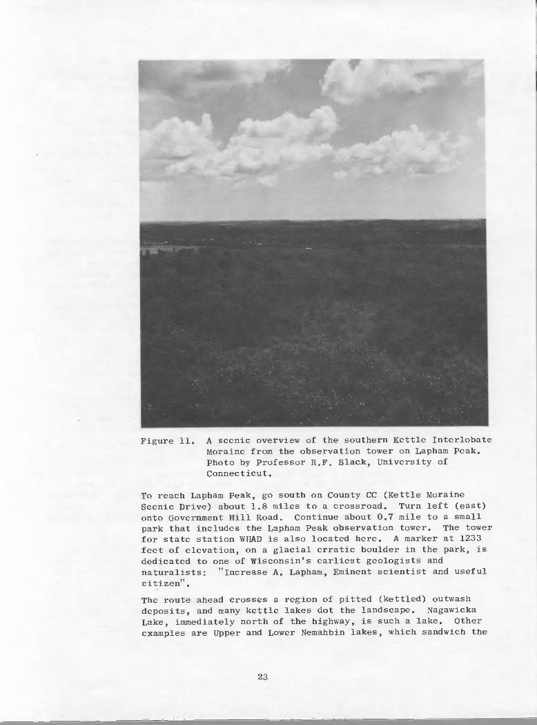
Figure 11. A scenic overview of the southern Kettle InterlobateMoraine from the observation tower on Lapham Peak.Photo by Professor R.F. Black, University ofConnecticut.
To reach Lapham Peak, go south on County CC (Kettle MoraineScenic Drive) about 1.8 miles to a crossroad. Turn left (east)
onto Government Hill Road. Continue about 0.7 mile to a smallpark that includes the Lapham Peak observation tower. The towerfor state station WHAD is also located here. A marker at 1233feet of elevation, on a glacial erratic boulder in the park, isdedicated to one of Wisconsin's earliest geologists andnaturalists: "Increase A. Lapham, Eminent scientist and usefulcitizentt.
The route ahead crosses a region of pitted (kettled) outwashdeposits, and many kettle lakes dot the landscape. NagawickaLake, immediately north of the highway, is such a lake. Otherexamples are Upper and Lower Nemahbin lakes, which sandwich the
23
Figure 11. A scenic overview of the southern Kettle InterlobateMoraine from the observation tower on Lapham Peak.Photo by Professor R.F. Black, University ofConnecticut.
To reach Lapham Peak, go south on County CC (Kettle MoraineScenic Drive) about 1.8 miles to a crossroad. Turn left (east)onto Government Hill Road. Continue about 0.7 mile to a smallpark that includes the Lapham Peak observation tower. The towerfor state station WHAD is also located here. A marker at 1233feet of elevation, on a glacial erratic boulder in the park, isdedicated to one of Wisconsin's earliest geologists andnaturalists: "Increase A. Lapham, Eminent scientist and usefulcitizen".
The route ahead crosses a region of pitted (kettled) outwashdeposits, and many kettle lakes dot the landscape. NagawickaLake, immediately north of the highway, is such a lake. Otherexamples are Upper and Lower Nemahbin lakes, which sandwich the
23

Mileages
interstate about 1 mile west of here. The ice blocks whichformed these lake basins were derived from the Green Bay lobealong the western edge of the Interlobate Moraine.
60 (23) The interstate approaches the crest of the Interlobate Moraine.A small ski area south of the highway utilizes part of thisslope. From the crest of this ridge, the radio tower andobservation tower on Lapham Peak are visible south of the highway.
The Kettle Interlobate Moraine, which trends northeasterly acrossWisconsin for about 130 miles, from Walworth to Kewaunee countiesis the premier glacial feature in Wisconsin. It is probablethat the resistant Silurian dolomite influenced the positionof the interlobate deposits in this area, by retarding thespread of the Green Bay lobe.
Within this morainal complex, the country is rolling and rugged,with abundant knobs and kettles. This feature formed during theWoodfordian glacial advance by a juxtapositioning of the terminalmoraines of the Green Bay and Lake Michigan lobes. Betweenthese icy walls, complex drainageways developed, and meitwatersreworked some of the morainal materials. The resultant depositsare a mixture of sand, gravel, boulders, and clayey till. Muchof the coarser material was derived from the Silurian dolomite,but igneous and metamorphic rock types from far to the northare also present.
61 (22) Wisconsin 83 exit. This'highway follows low ground along anagandoned drainage channel which carried the last meltwaterthat drained southward through this part of the Kettle Inter—lobate Moraine. Water drained down this .25 mile wide valleyuntil it reached Wales, about 3 miles to the south, where itcut through the Interlobate Moraine to flow west. Graveloutwash terraces flank this drainage, and a remnant of a highterrace is visible on the east side of this valley.
62 (21) Pewaukee Lake lies to the north. The church at Holy Hill, akame perched high on the Interlobate Moraine, is also visibleto the north on a clear day. Pewaukee Lake occupies a pre—glacial river valley which was scoured into the Upper OrdovicianMaquoketa Shale. This ancient valley was blocked by morainaldebris deposited along its eastern margins by the Lake Michiganlobe during the Woodfordian ice advance.
63 (20) Ground moraine deposits in this area are thin. North of thehighway on the west edge of the Tumblebrook golf course, thereis a small quarry in Silurian dolomite. Glacial striae on bed-rock in this area indicate that ice movement was west—southwest.
South of the road, the names of a subdivision (PebbleValley), and a farm (Stoney Hill), bear testimony to thecharacter of the morainal material.
24
Mileages
interstate about 1 mile west of here. The ice blocks whichformed these lake basins were derived from the Green Bay lobealong the western edge of the Interlobate Moraine.
60
61
62
63
(23)
(22)
(21)
(20)
The interstate approaches the crest of the Interlobate Moraine.A small ski area south of the highway utilizes part of thisslope. From the crest of this ridge, the radio tower andobservation tower on Lapham Peak are visible south of the highway.
The Kettle Interlobate Moraine, whi.ch trends northeasterly acrossWisconsin for about 130 miles, from Walworth to Kewaunee countiesis the premier glacial feature in Wisconsin. It is probablethat the resistant Silurian dolomite influenced the positionof the interlobate deposits in this area, by retarding thespread of the Green Bay lobe.
Within this morainal complex, the country is rolling and rugged,with abundant knobs and kettles. This feature formed during theWoodfordian glacial advance by a juxtapositioning of the terminalmoraines of the Green Bay and Lake Michigan lobes. Betweenthese icy walls, complex drainageways developed, and meltwatersreworked some of the morainal materials. The resultant depositsare a mixture of sand, gravel, boulders, and clayey till. Muchof the coarser material was derived from the Silurian dolomite,but igneous and metamorphic rock types from far to the northare also present.
Wisconsin 83 exit. This/highway follows low ground along anagandoned drainage channel which carried the last meltwaterthat drained southward through this part of the Kettle Interlobate Moraine. Water drained down this .25 mile wide valleyuntil it reached Wales, about 3 miles to the south, where itcut through the Interlobate Moraine to flow west. Graveloutwash terraces flank this drainage, and a remnant of a highterrace is visible on the east side of this valley.
Pewaukee Lake lies to the north. The church at Holy Hill, akame perched high on the Interlobate Moraine, is also visibleto the north on a clear day. Pewaukee Lake occupies a preglacial river valley which was scoured into the Upper OrdovicianMaquoketa Shale. This ancient valley was blocked by morainaldebris deposited along its eastern margins by the Lake Michiganlobe during the Woodfordian ice advance.
Ground moraine deposits in this area are thin. North of thehighway on the west edge of the Tumblebrook golf course, thereis a small quarry in Silurian dolomite. Glacial striae on bedrock in this area indicate that ice movement was west-southwest.
South of the road, the names of a subdivision (PebbleValley), and a farm (Stoney Hill), bear testimony to thecharacter of the morainal material.
24
Mileages
65 (18) Exit County G to Pewaukee. A drumlin field lies south of thehighway for the next several miles. These east-west trendingdrumlins are composed of sandy clay till that contains abundantboulders.
68 (15) Exit County F. West of this intersection, the route crossedthe Pewaukee River, which is tributary to the Fox. This valleyis paralleled by outwash terraces, which are commercial sourcesof sand and gravel in this area.
69 (14) Exit Wisconsin 164 to Sussex and Waukesha. East—west trendingdrumlins are north and south of the highway.
Colonel Dunbar, while visiting Waukesha in 1869, drank fromsome of the springs which issue from the glacial drift in thisarea with high amounts of dissolved calcium magnesium bicarbonate.Upon deciding that the local mineral waters had eliminated his!tincurable ailments", he began to advertise his cure nationwide,and Waukesha soon became a fashionable health spa. Althoughthis fad waned after about 30 years, bottled spring water isstill a Waukesha product.
Waukesha is located on the Fox River. Outwash terraces alongthis river are important commercial sources for sand and gravel.Since the glacial drift is quite thin in this region, Siluriandolomite is extensively quarried along the valley oC the Foxfrom the Waukesha area northward to Sussex, Lannon, andMenomonee Falls.
71 (12) Exit U.S. 18 (Blue Mound Road) to Waukesha and Wisconsin StatePatrol headquarters.
74 (9) Exit Moorland Road. The flat terrain here is poorly drained,clay—rich ground moraine. Ditching and channelization wererequired for the extensive development of the land north ofthe highway. The golf course to the south represents a moreintelligent land use. A few isolated patches of moraine, andseveral east—west trending drumlins rise above the generallyswampy ground.
The route ahead descends a prominent ridge, which is part ofthe Woodfordian Lake Border recessional moraine system. SunnySlope Road traverses this crest, which forms the drainage dividebetween Lake Michigan and the drainage basin of the Fox River.The Fox flows southward parallel to the Woodfordian morainesto reach the Illinois River, and ultimately the Gulf of Mexicovia the Mississippi.
76 (7) Milwaukee/Waukesha county line. Enter Milwaukee County.
78 (5) Exit 1—894 (U.S. 45) south to Chicago and U.S. 45 north toFond du Lac. The Milwaukee County Zoo is northwest of thisintersection.
25
Mileages
65
68
69
71
74
76
78
(18)
(15)
(14)
(12)
(9)
(7)
(5)
Exit County G to Pewaukee. A drumlin field lies south of thehighway for the next several miles. These east-west trendingdrumlins are composed of sandy clay till that contains abundantboulders.
Exit County F. West of this intersection, the route crossedthe Pewaukee River, which is tributary to the Fox. This valleyis paralleled by outwash terraces, which are commercial sourcesof sand and gravel in this area.
Exit Wisconsin 164 to Sussex and Waukesha. East-west trendingdrumlins are north and south of the highway.
Colonel Dunbar, while visiting Waukesha in 1869, drank fromsome of the springs which issue from the glacial drift in thisarea with high amounts of dissolved calcium magnesium bicarbonate.Upon deciding that the local mineral waters had eliminated his"incurable ailments", he began to advertise his cure nationwide,and Waukesha soon became a fashionable health spa. Althoughthis fad waned after about 30 years, bottled spring water isstill a Waukesha product.
Waukesha is located on the Fox River. Outwash terraces alongthis river are important commercial sources for sand and gravel.Since the glacial drift is quite thin in this region, Siluriandolomite is extensively quarried along the valley of the Foxfrom the Waukesha area northward to Sussex, Lannon, andMenomonee Falls.
Exit U.S. 18 (Blue Mound Road) to Waukesha and Wisconsin StatePatrol headquarters.
Exit Moorland Road. The flat terrain here is poorly drained,clay-rich ground moraine. Ditching and channelization wererequired for the extensive development of the land north ofthe highway. The golf course to the south represents a moreintelligent land use. A few isolated patches of moraine, andseveral east-west trending drumlins rise above the generallyswampy ground.
The route ahead descends a prominent ridge, which is part ofthe Woodfordian Lake Border recessional moraine system. SunnySlope Road traverses this crest, which forms the drainage dividebetween Lake Michigan and the drainage basin of the Fox River.The Fox flows southward parallel to the Woodfordian morainesto reach the Illinois River, and ultimately the Gulf of Mexicovia the Mississippi.
Milwaukee/Waukesha county line. Enter Milwaukee County.
Exit 1-894 (U.S. 45) south to Chicago and U.S. 45 north toFond du Lac. The Milwaukee County Zoo is northwest of thisintersection.
25

Mileages
79 (4) Exit Wisconsin 181 (84th Street). The Wisconsin State FairPark grounds and an Olympic—size outdoor ice rink are southeastof this junction. The interstate traverses Wisconsinan(Woodfordian) ground moraine and recessional moraines of theLake Border system. The highway here is essentially parallelto the east—west direction of ice movement, and consequentlythe inorainic ridges trend north-south. About 100 feet of glacialdeposits, primarily a boulder clay till, overlie Siluriandolomite in this area.
81 (2) U.S. 41 exit (north and south). Milwaukee County Stadium, homeof the Milwaukee Brewers and also the site of the Milwaukeegames of the Green Bay Packers, is just west of this junction.The large hill southwest of the stadium is a Silurian dolomiteexposure on the grounds of the U.S. Veterans AdministrationHospital.
82 (1) Route parallels the industrial complex along the east—westtrending Menomonee River valley. Three large, glass domes inMitchell Park are visible to the south. One contains a displayof vegetation native to a desert environment, another featurestropical plants, and the last houses local flora and is oftenused for special flower shows.
83 (0) Junction 1—94 with 1—43 (U.S. 141) and 1—794. The MilwaukeeHarbor is to the woutheast, toward the high—rise HarborFreeway bridge along the lakeshore.
Three rivers merge at the Milwaukee Harbor, the MenomoneeRiver flows from the north and west, the Milwaukee River comesfrom the north, and the Kinnickinnic River originates to thewest and south.
Milwaukee grew from three settlements that were originallyseparated by these rivers. Walker's Point, east of theKinnickinnic River, is now dominated by the towering clock ofthe Allen Bradley Company. The Milwaukee River flowed betweenKilbourntown on the west and Juneautown to the east.
The high smokestack to the east is part of the Jones IslandMetropolitan Sewage Plant. Here, sewage sludge is dried andconverted to Milorganite, a commercial fertilizer.
Jones Island, an artificially breached peninsula, also containsa tanker pier, cargo terminals and a heavylift wharf, and isheadquarters for the Port of Milwaukee. Milwaukee's innerharbor was developed by an enlargement of the lower KinnickinnicRiver, and it serves as the service and wintering area for partof U.S. Steel's iron ore carrier fleet.
END OF LOG
Proceed through downtown Milwaukee to the Pfister Hotel; head-quarters for the 24th annual meeting of the Institute on LakeSuperior Geology.
We hope you enjoy your stay in Milwaukee!
26
Mileages
79
81
82
83
(4)
(2)
(1)
(0)
Exit Wisconsin 181 (84th Street). The Wisconsin State FairPark grounds and an Olympic-size outdoor ice rink are southeastof this junction. The interstate traverses Wisconsinan(Woodfordian) ground moraine and recessional moraines of theLake Border system. The highway here is essentially parallelto the east-west direction of ice movement, and consequentlythe morainic ridges trend north-south. About 100 feet of glacialdeposits, primarily a boulder clay till, overlie Siluriandolomite in this area.
u.S. 41 exit (north and south). Milwaukee County Stadium, homeof the Milwaukee Brewers and also the site of the Milwaukeegames of the Green Bay Packers, is just west of this junction.The large hill southwest of the stadium is a Silurian dolomiteexposure on the grounds of the U.S. Veterans AdministrationHospital.
Route parallels the industrial complex along the east-westtrending Menomonee River valley. Three large, glass domes inMitchell Park are visible to the south. One contains a displayof vegetation native to a desert environment, another featurestropical plants, and the last houses local flora and is oftenused for special flower shows.
Junction 1-94 with 1-43 (U.S. 141) and 1-794. The MilwaukeeHarbor is to the woutheast, toward the high-rise HarborFreeway bridge along the lakeshore.
Three rivers merge at the Milwaukee Harbor, the MenomoneeRiver flows from the north and west, the Milwaukee River comesfrom the north, and the Kinnickinnic River originates to thewest and south.
Milwaukee grew from three settlements that were originallyseparated by these rivers. Walker's Point, east of theKinnickinnic River, is now dominated by the towering clock ofthe Allen Bradley Company. The Milwaukee River flowed betweenKilbourntown on the west and Juneautown to the east.
The high smokestack to the east is part of the Jones IslandMetropolitan Sewage Plant. Here, sewage sludge is dried andconverted to Milorganite, a commercial fertilizer.
Jones Island, an artificially breached peninsula, also containsa tanker pier, cargo terminals and a heavylift wharf, and isheadquarters for the Port of Milwaukee. Milwaukee's innerharbor was developed by an enlargement of the lower KinnickinnicRiver, and it serves as the service and wintering area for partof U.S. Steel's iron ore carrier fleet.
END OF LOG
Proceed through downtown Milwaukee to the Pfister Hotel; headquarters for the 24th annual meeting of the Institute on LakeSuperior Geology.
We hope you enjoy your stay in Milwaukee!
26

GX)LOGICAL STOP DESCRIPTIONS
Page
Stop 1 — Hoadley Hill 28
Upper part of the St. Peter Sandstone, the GlenwoodFormation, a complete section of the PlattevilleFormation, and the lower part of the Decorah Formation
Stop 2 — Section 2 Quarry 32
Quimby's Mill (upper part of the PlattevilleFormation)
Stop 3 — Potosi. Hill 33
Upper part of the Platteville Formation, the DecorahFormation, and the lower part of the Galena Formation
Stop 4 — St. John Mine (Snake Cave) 37
Dunleith Member (cherty lower unit) and Wise Lake(non—cherty upper unit) of the Galena Formation
27
—
GIDLOGICAL SIDP DESCRIPTIONS
Stop I - Hoadley Hill
Upper part of the St. Peter Sandstone, the GlenwoodFormation, a complete section of the PlattevilleFormation, and the lower part of the Decorah Formation
Stop 2 - Section 2 Quarry
QUimby's Mill (upper part of the PlattevilleFormation)
Stop 3 - Potosi Hill
Upper part of the Platteville Formation, the DecorahFormation, and the lower part of the Galena Formation
Stop 4 - St. John Mine (Snake Cave)
Dunleith Member (cherty lower unit) and Wise Lake(non-cherty upper unit) of the Galena Formation
27
28
32
33
37

Title: Hoadley Hill
Location: Exposure in roadcut at north side of U. S. Highway 151 about 6.5miles southwest of Platteville in the NW, NWI, Sec. 12, T.2N., R.2W., GrantCounty (Dlckeyville 7.5—minute topographic quadrangle, 1972),
Author: M. E. Ostrom (modified from Agnew et. al., 1956)
Description: This is the reference section for the Platteville Formation.The strata4 exposed lere are the upper part of the St. Peter Sandstone, theGlenwood Formation, a complete section of the Platteville Formation, and thelower part of the Decorah Formation. Description from Agnew et. al,, (1956)
is:
ORDOVICIAN SYSTEM
Decorah Formation
Spechts Ferry Shale Member (+1.0 feet)
62,9' — 63.4'
62.7' — 62.9'
62.5' — 62.7'
0.5'+ Shale, bluish—green.
0.2'
0.2'
Bentonite, white; weathers orange brown.
Shale, yellowish—green above to bluish-green below.
28
Title: Hoadley Hill
Location: Exposure in roadcut at north side of U. S. Highway 151 about 6.5miles southwest of Platteville in the NW!, NWt, Sec. 12, T.2N., R.2W., GrantCounty (Dickeyville 7.5-minute topographic quadrangle, 1972).
Author: M. E. Ostrom (modified from Agnew et. al., 1956)
Description: This is the reference section for the Platteville Formation.The strat~exposed qere are the upper part of the St. Peter Sandstone, theGlenwood Formation, a complete section of the Platteville Formation, and thelower part of the Decorah Formation. Description from Agnew et. al., (1956)is:
ORDOVICIAN SYSTEM
Decorah Formation
Spechts Ferry Shale Member (+1.0 feet)
62.9' - 63.4'
62.7' - 62.9'
62.5' - 62.7'
0.5'+
0.2'
0.2'
Shale, bluish-green.
Bentonite, white; weathers orange brown.
Shale, yellowish-green above to bluish-green below.
28
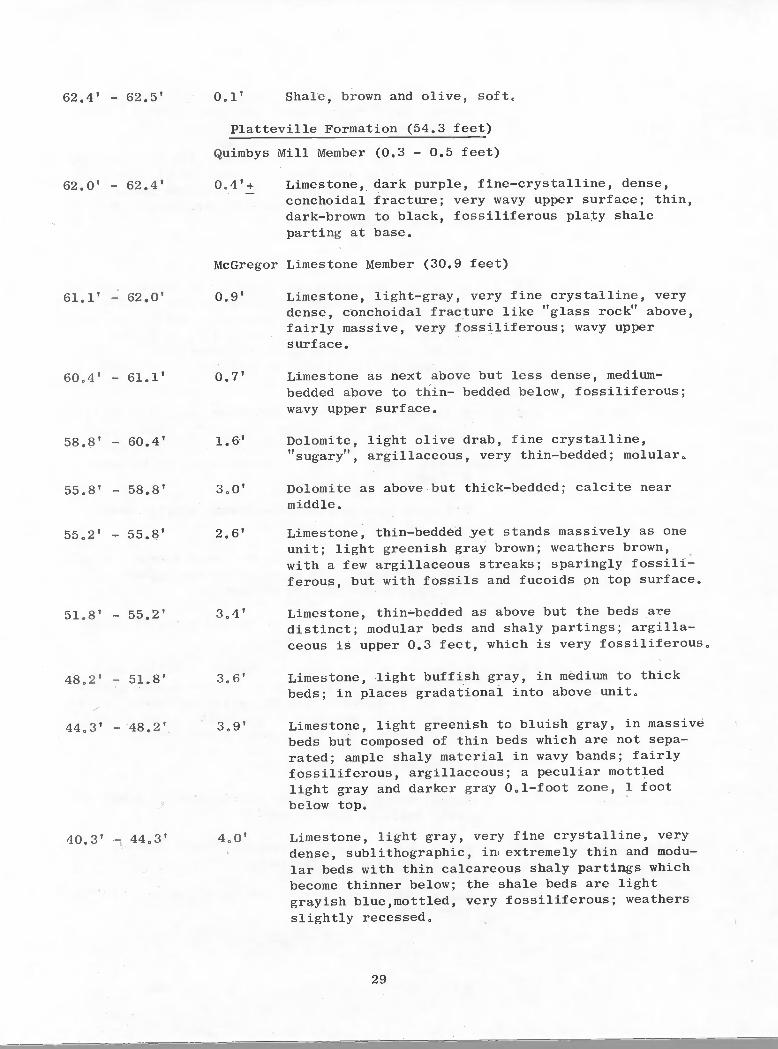
62.4' — 62.5' 001' Shale, brown and olive, soft.
Platteville Formation (54.3 feet)
Quimbys Mill Member (0.3 — 0.5 feet)
62.0' — 62.4' 0.4'± Limestone, dark purple, fine—crystalline, dense,conchoidal fracture; very wavy upper surface; thin,dark—brown to black, fossiliferous platy shaleparting at base.
McGregor Limestone Member (30.9 feet)
61.1' — 62.0' 0.9' Limestone, light—gray, very fine crystalline, verydense, conchoidal fracture like "glass rock" above,fairly massive, very fossiliferous; wavy uppersurface.
60,4' — 61.1' 0.7' Limestone as next above but less dense, medium—bedded above to thin- bedded below, fossiliferous;wavy upper surface.
58.8' — 60.4' 1.6' Dolomite, light olive drab, fine crystalline,"sugary", argillaceous, very thin—bedded; molular,
55.8' — 58.8' 3.0' Dolomite as above but thick—bedded; calcite nearmiddle.
55.2' — 55.8' 2.6' Limestone, thin—bedded yet stands massively as oneunit; light greenish gray brown; weathers brown,with a few argillaceous streaks; sparingly fossili-ferous, but with fossils and fucoids on top surface.
51.8' — 55.2' 3.4' Limestone, thin—bedded as above but the beds aredistinct; modular beds and shaly partings; argilla-ceous is upper 0.3 feet, which is very fossiliferous,
48,2' — 51.8' 3,6' Limestone, light buff ish gray, in medium to thickbeds; in places gradational into above unit,
44,3' — 48.2' 3,9' Limestone, light greenish to bluish gray, in massivebeds but composed of thin beds which are not sepa-rated; ample shaly material in wavy bands; fairlyfossiliferous, argillaceous; a peculiar mottledlight gray and darker gray 0,1-foot zone, 1 footbelow top,
40.3' — 44,3' 4,0' Limestone, light gray, very fine crystalline, verydense, sublithographic, in extremely thin and modu-lar beds with thin calcareous shaly partings whichbecome thinner below; the shale beds are lightgrayish blue,mottled, very fossiliferous; weathersslightly recessed,
29
62.4' - 62.5' 0.1' Shale, brown and olive, soft.
Platteville Formation (54.3 feet)
Quimbys Mill Member (0.3 - 0.5 feet)
62.0' - 62.4' 0.4'+ Limestone, dark purple, fine-crystalline, dense,conchoidal fracture; very wavy upper surface; thin,dark-brown to black, fossiliferous platy shaleparting at base.
McGregor Limestone Member (30.9 feet)
61.1' - 62.0'
60.4' - 61. l'
58.8' - 60.4'
55.8' - 58.8'
55.2' - 55.8'
51.8' - 55.2'
48.2' - 51.8'
44.3' - 48.2'
40.3' - 44.3'
0.9'
0.7'
1.6'
3.0'
3.4'
3.6'
3.9'
4.0'
Limestone, light-gray, very fine crystalline, verydense, conchoidal fracture like "glass rock" above,fairly massive, very fossiliferous; wavy uppersurface.
Limestone as next above but less dense, mediumbedded above to thin- bedded below, fossiliferous;wavy upper surface.
Dolomite, light olive drab, fine crystalline,"sugary", argillaceous, very thin-bedded; molular.
Dolomite as above but thick-bedded; calcite nearmiddle.
Limestone, thin-bedded yet stands massively as oneunit; light greenish gray brown; weathers brown,with a few argillaceous streaks; sparingly fossiliferous, but with fossils and fucoids on top surface.
Limestone, thin-bedded as above but the beds a~e
distinct; modular beds and shaly partings; argillaceous is upper 0.3 feet, which is very fossiliferous.
Limestone, light buffish gray, in medium to thickbeds; in places gradational into above unit.
Limestone, light greenish to bluish gray, in massivebeds but composed of thin beds which are not separated; ample shaly material in wavy bands; fairlyfossiliferous, argillaceous; a peculiar mottledlight gray and darker gray O.l-foot zone, 1 footbelow top.
Limestone, light gray, very fine crystalline, verydense, sublithographic, in. extremely thin and modular beds with thin calcareous shaly partings whichbecome thinner below; the shale beds are lightgrayish blue,mottled, very fossiliferous; weathersslightly recessed.
29

36.7' — 40.3' 3.6' Limestone, as above, but beds are not quite asthin; fossiliferous; poor gastropod zone 1.7 feetabove base; shaly zone at base,
33.1' — 36.7' 3.6' Limestone, dolomite, light—gray, fine crystalline,very slightly argillaceous, very fossiliferous,medium—bedded; Indistinct argillaceous partings,not wavy; calcite and limonite, especially Inbasal 0.6 feet.
Pecatonica Dolomite Member (21.5 feet)
28.3' — 33.1' 4.8' Dolomite, light grayish brown, very coarse crystal-line and vuggy, upper 2 feet a mixture of lithologyand a somewhat argillaceous fine crystalline "sugary"laminated dolomite; a 1-foot bed of very vuggydolomite from 1.8 to 2.8 feet above base; shalyin lower part; stylolitic partings 1 foot abovebase.
21.4' — 28.3' 6.9' DolomIte, mediuin gray, laminated, somewhat argil—laceous, fine—crystalline "sugary", fossiliferous,especially in lower 0.9 feet; medium— to thick—bedded; shaly at top; weathers brownish in lower2.5 feet.
17.8' — 21.4' 3.6' Dolomite, medium gray, laminated, argillaceous;very fossiliferous partings.
16.4' — 17.8' 1.4' Dolomite, light grayish brown, very coarse crystal-line and vuggy; thin brownish gritty dolomiticand platy shaly parting at top.
13.6' — 16.4' 2.8' Dolomite, medium gray, laminated, somewhat argil-laceous, fine crystalline.
11,6' — 13.6' 2.0' Dolomite, medium gray, laminated, argillaceous,silty and sandy with fine to coarse quartz grainssimilar to those of the St. Peter Sandstone, phos-phate nodules abundant (especially in two zones,one at base, the other 1 foot above base).
Glenwood Formation (1.5 feet)
11.2' — 11.6' 0.4' Shale, sandy with rounded quartz grains, khaki todrab, soft; phosphate nodules.
11.0' — 11.2' 0.2' Shale, sandy, olive to grayish brown; mottledyellowish brown, friable.
10.4' — 11,0' 0.6' Shale, sandy, medium— to dark—gray, olive, blocky,
very hard,
30
36.7' - 40.3'
33.1' - 36.7'
3.6'
3.6'
Limestone, as above, but beds are not quite asthin; fossiliferous; poor gastropod zone 1.7 feetabove base; shaly zone at base.
Limestone~ dolomite, light-gray, fine crystalline,very slightly argillaceous, very fossiliferous,medium-bedded; indistinct argillaceous partings,not wavy; calcite and limonite, especially inbasal 0.6 feet.
Pecatonica Dolomite Member (21.5 feet)
28.3' - 33.1'
21.4' - 28.3'
17.8' - 21.4'
16.4' - 17.8'
13.6' - 16.4'
H.6' - 13.6'
4.8'
6.9'
1.4'
2.8'
2.0'
Dolomite, light grayish brown, very coarse crystalline and vuggy, upper 2 feet a mixture of lithologyand a somewhat argillaceous fine crystalline "sugary"laminated dolomite; a I-foot bed of very vuggydolomite from 1.8 to 2.8 feet above base; shalyin lower part; stylolitic partings 1 foot abovebase.
Dolomite, medium-gray, laminated, somewhat argillaceous, fine-crystalline "sugary", fossiliferous,especially in lower 0.9 feet; medium- to thickbedded; shaly at top; weathers brownish in lower2.5 feet.
Dolomite, medium gray, laminated, argillaceous;very fossiliferous partings.
Dolomite, light grayish brown, very coarse crystalline and vuggy; thin brownish gritty dolomiticand platy shaly parting at top.
Dolomite, medium gray, laminated, somewhat argillaceous, fine crystalline.
Dolomite, medium gray, laminated, argillaceous,silty and sandy with fine to coarse quartz grainssimilar to those of the St. Peter Sandstone, phosphate nodules abundant (especially in two zones,one at base, the other 1 foot above base).
Glenwood Formation (1.5 feet)
11.2' - 11.6'
H.O' - 11.2'
10.4' - H.O'
0.4'
0.2'
0.6'
Shale, sandy with rounded quartz grains, khaki todrab, soft; phosphate nodules.
Shale, sandy, olive to grayish brown; mottledyellowish brown, friable.
Shale, sandy, medium- to dark-gray, olive, blocky,very hard.
30

10.1' — 10.4' 0.3' Shale, medium-gray, blocky, hard, sandy; streakof carbonaceous material at top.
St. Peter Sandstone Formation (÷10,2 feet)
10.0' — 10.1' 0.1' Sandstone, red and white; rounded; frosted, coarseto medium—grained.
9,8' — 10.0' 0.2' Sandstone, gray, pinkish, very friable.
9.7' — 9.8' 0,1' Sandstone, brown, iron—stained, hard.
8.4' — 9.7' 1.3' Sandstone, yellow to gray, very friable, with irre-gular lower surface.
8.3' — 8.4' 0,1' Sandstone, light—gray, very friable.
8,1' — 8,3' 0.2' Sandstone, yellow to dark—brown, laminated, hard,
7.0' — 8.1' 1.1' Sandstone, gray and yellow; hard irregular lowersurface.
0.0' — 7,0' 7.0'+ Sandstone as above, but medium— to fine-grained;spoils.
BASE OF EXPOSURE
Significance: This is the reference section for the Platteville Formation.The contact relationships and lithologies of the St. Peter, Glenwood, Platte—yule, and Decorah Formations can be examined.
Note the lithology, mineralogy, and structure of the St. Peter Formation,What direction did it come from? Does it contain evidence of life? How doyou account for its mineral homegeniety? What was the environment of deposi-tion? Does it change toward the top? What is the significance of no change?of change? What is the relationship of the St. Peter to the Glenwood? Notethe various beds of the Glenwood, What is their significance? If they couldbe traced for long distances of several hundred miles, what would be the signi-ficance? What is the nature and significance of the Glenwood/Platteville con-tact? Note the variable Platteville lithology, i.e. phosphate nodule beds,fossil beds, sandy beds, etc. What is their significance? What would be thesignificance if they could be traced several.hundred miles?
References: Dapples, 1955; Agnew et. al., 1956; Templeton and Willman, 1963;Ostrom, 1964 and 1970.
31
10.1' - 10.4' 0.3' Shale, medium-gray, blocky; hard, sandy; streakof carbonaceous material at top.
St. Peter Sandstone Formation (+10.2 feet)
10.0' - 10.1'
9.8' - 10.0'
9.7' - 9.8'
8.4' 9.7'
8.3' - 8.4'
8.1' - 8.3'
7.0' - 8.1'
0.0' - 7.0'
0.1'
0.2'
0.1'
1. 3'
0.1'
0.2'
1.1 '
7.0'+
Sandstone, red and white; rounded; frosted, coarseto medium-grained.
Sandstone, gray, pinkish, very friable.
Sandstone, brown, iron-stained, hard.
Sandstone, yellow to gray, very friable, with irregular lower surface.
Sandstone, light-gray, very friable.
Sandstone, yellow to dark-brown, laminated, hard.
Sandstone, gray and yellow; hard irregular lowersurface.
Sandstone as above, but medium- to fine-grained;spoils.
BASE OF EXPOS URE
Significance: This is the reference section for the Platteville Formation.The contact relationships and lithologies of the St. Peter, Glenwood, Platteville, and Decorah Formations can be examined.
Note the lithology, mineralogy, and structure of the St. Peter Formation.What direction did it come from? Does it contain evidence of life? How doyou account for its mineral homegeniety? What was the environment of deposition? Does it change toward the top? What is the significance of no change?of change? What is the relationship of the St. Peter to the Glenwood? Notethe various beds of the Glenwood. What is their significance? If they couldbe traced for long distances of several hundred miles, what would be the significance? What is the nature and significance of the Glenwood/Platteville contact? Note the variable Platteville lithology, i.e. phosphate nodule beds,fossil beds, sandy beds, etc. What is their significance? What would be thesignificance if they could be traced several. hundred miles?
References: Dapples, 1955; Agnew et. al., 1956; Templeton and Willman, 1963;Ostrom, 1964 and 1970.
31

Title: Section 2 Quarry
Location: Abandoned quarry on west side of gravel road about 0.7 miles northof U. S. Highway 151 about 0.3 miles west of Piddington Cementary in the SW,SW, SE, Sec. 2, T. 2 N., R. 2 W., Grant County (Dickeyville 7.5—minutetopographic quadrangle, 1972). Map location on Hoadley Hill description.
Description: See Hoadley Hill description. Quimby's Mill Member of Decorah,Formation is well exposed. Excellent Middle Ordovician fossil locality.
32
Title: Section 2 Quarry
Location: Abandoned quarry on west side of gravel road about 0.7 miles northof U. S. Highway 151 about 0.3 miles west of Piddington Cementary in the SW!,SW!, SE!, Sec. 2, T. 2 N., R. 2 W., Grant County (Dickeyville 7.S-minutetopographic quadrangle, 1972). Map location on Hoadley Hill description.
Description: See Hoadley Hill description. QUimby's Mill Member of Decorah"Formation is well exposed. Excellent Middle Ordovician fossil locality.
32
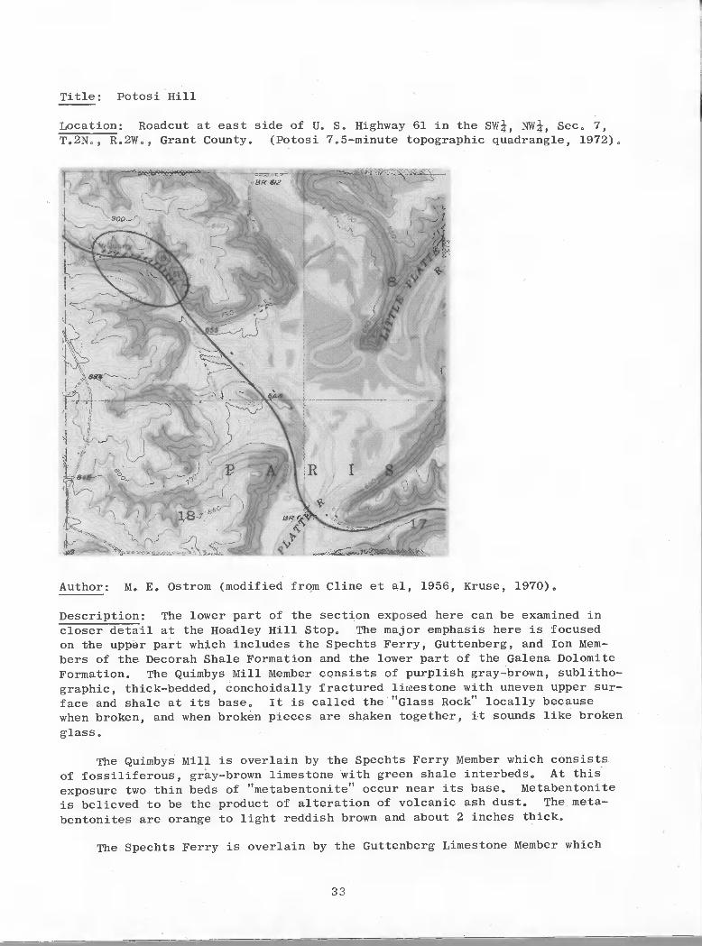
Title: Potosi Hill
Location: Roadcut at east side of U. S. Highway 61 in the SW, NW, Sec. 7,T.2N., R.2W,, Grant County. (Potosi 7.5-minute topographic quadrangle, 1972),
Author: M. E. Ostrom (modified from dine et al, 1956, Kruse, 1970).
Description: The lower part of the section exposed here can be examined incloser detail at the Hoadley Hill Stop. The major emphasis here is focusedon the uppör part which includes the Spechts Ferry, Guttenberg, and Ion Mem-bers of the Decorah Shale Formation and the lower part of the Galena DolomiteFormation. The Quimbys Mill Member consists of purplish gray-brown, sublitho—graphic, thick—bedded, conchoidally fractured limestone with uneven upper sur-face and shale at its base. It is called the "Glass Rock" locally becausewhen broken, and when broken pieces are shaken together, it sounds like broken
glass.
The Quimbys Mill is overlain by the Spechts Ferry Member which consistsof fossiliferous, gray—brown limestone with green shale interbeds. At this
exposure two thin beds of "metabentonite" occur near its base, Metabentonite
is believed to be the product of alteration of volcanic ash dust. The meta-
bentonites are orange to light reddish brown and about 2 inches thick.
The Spechts Ferry is overlain by the Guttenberg Limestone Member which
33
Title: Potosi Hill
Location: Roadcut at east side of U. S. Highway 61 in the SW!, NW!, Sec. 7,T.2N., R.2W., Grant County. (Potosi 7.5-minute topographic quadrangle, 1972).
Author: M. E. Ostrom (modified from Cline et aI, 1956, Kruse, 1970).
Description: The lower part of the section exposed here can be examined incloser detail at the Hoadley Hill Stop. The major emphasis here is focusedon the upper part wh~ch includes the Spechts Ferry, Guttenberg, and Ion Members of the Decorah Shale Formation and the lower part of the Galena DolomiteFormation. The Quimbys Mill Member consists of purplish gray-brown, sublithographic, thick-bedded, conchoidally fractured lilnestone with uneven upper surface and shale at its base. It is called the "Glass Rock" locally becausewhen broken, and when broken pieces are shaken together, it sounds like brokenglass.
The Quimbys Mill is overlain by the Spechts Ferry Member which consistsof fossiliferous, gray-brown limestone with green shale interbeds. At thisexposure two thin beds of "metabentonite" occur near its base. Metabentoniteis believed to be the product of alteration of volcanic ash dust. The metabentonites are orange to light reddish brown and about 2 inches thick.
The Spechts Ferry is overlain by the Guttenberg Limestone Member which
33

consists of hard, finely crystalline, thin—bedded, fossiliferous, light brown,limestone with brown carbonaceous shale interbeds, The presence of theseinterbeds has led to the member being referred to as the "Oil Rock" in thesouthwest Wisconsin zinc—lead mineral district,
The Ion Dolomite Member overlies the Guttenberg. It is a gray to bluedolomite, medium—crystalline, and medium—to thick—bedded with green shaleinterbeds, It is locally called the "Bluet'.
The Galena Dolomite Formation overlies the Ion,drab, cherty, thick—bedded, vuggy dolomite with mediumThe basal contact is gradational. A zone of Prasoporathe top of the Ion Member in some areas. It is absent
It is a light buff toto coarse sugary grains,insularis Ulrich markshere,
Good fossil hunting in the Spechts Ferry and Guttenberg Members.
Near the north end of the roadcut there is a quarry in which can be seenan example of "pitch—and—flat" structure which is the main site of zinc andlead mineralization in the district, Here there is no mineralization,
Description of outcrop follows:
ORDOVICIAN SYSTEM
45.8' — 65.8'
Galena Dolomite FormationCherty Unit
20.0' Dolomite, yellowish-buff, medium—to coarse—grained,vuggy, abundant white chert in upper 10',
Decorah Formation (43,8 feet)
Ion Dolomite Member (19,5 feet)(Gray unit)
38 3' — 45 8'
33,8' — 38.3'
32,8' — 33.8'
27.2' — 32.3'
26.3' — 27,2'
7,0' Dolomite, buff, thick-to massive—bedded, vuggy,green shale partings throughout, sparry calcitepresent.
5.0' Covered interval,
1.5' Dolomite, buff, medium—grained, medium—bedded,with green shale partings,
(Blue unit)
5.1' Dolomite, purplish gray, medium—grained, slightlyfossiliferous. Green shale present as partings,and as a 05' bed 0.8' below the top of the inter-val, calcite present.
0,9' Shale, green. 0.3 green dolomitic shale in middleof interval,
Guttenberg Limestone Member (15.3' feet)
34
It is a light buff toto coarse sugary grains.insularis Ulrich markshere.
consists of hard, finely crystalline, thin-bedded, fossiliferous, light brown,limestone with brown carbonaceous shale interbeds. The presence of theseinterbeds has led to the member being referred to as the "Oil Rock" in thesouthwest Wisconsin zinc-lead mineral district.
The Ion Dolomite Member overlies the Guttenberg. It is a gray to bluedolomite, medium-crystalline, and medium-to thick-bedded with green shaleinterbeds. It is locally called the "Blue".
The Galena Dolomite Formation overlies the Ion.drab, cherty, thick-bedded, vuggy dolomite with mediumThe basal contact is gradational. A zone of Prasoporathe top of the Ion Member in some areas. It is absent
Good fossil hunting in the Spechts Ferry and Guttenberg Members.
Near the north end of the roadcut there is a quarry in which can be seenan example of "pitch-and-flat" structure which is the main site of zinc andlead mineralization in the district. Here there is no mineralization.
Description of outcrop follows:
ORDOVICIAN SYSTEM
Galena Dolomite FormationCherty Unit
45.8' - 65.8' 20.0' Dolomite, yellowish-buff, medium-to coarse-grained,vuggy, abundant white chert in upper 10'.
Decorah Formation (43.8 feet)
Ion Dolomite Member (19.5 feet)(Gray unit)
38.3' - 45.8'
33.8' - 38.3'
32.8' - 33.8'
27.2' - 32.3'
26.3' - 27.2'
7.0'
5.0'
5.1'
0.9'
Dolomite, buff, thick-to massive-bedded, vuggy,green shale partings throughout, sparry calcitepresent.
Covered interval.
Dolomite, buff, medium-grained, medium-bedded,with green shale partings.
(Blue unit)
Dolomite, purplish gray, medium-grained, slightlyfossiliferous. Green shale present as partings,and as a 0.5' bed 0.8' below the top of the interval, calcite present.
Shale, green. 0.3 green dolomitic shale in middleof interval.
Guttenberg Limestone Member (15.3' feet)
34

21.7' — 26.3' 4.6' Limestone, purplish brown, fine-grained to sublitho-graphic, fossiliferous, upper 1' fine—to medium—grained, brown shale present as partings, calciteand limonite after iron sulfide present in smallamounts.
21.6' — 21.7' 0.1' Metabentonite, brownish orange, crumbly, stickywhen wet.
12.0' - 21.6' 9.6' Limestone, purplish brown, sublithographic, thin-wavey—bedded, fossiliferous, brown carbonaceousshale present as thin beds and partings, calciteand limonite present.
11.0' — 12.0' 1.0' Limestone, brown—gray, Line—grained, thick-bedded.
Spechts Ferry Shale Member (9.0 feet)
10.2' — 11.0' 0.8' Shale, orange—gray, calcareous, and limestone, tan—gray, fine—grained, limestone 0.4' to 0.7' frombase of unit.
9.6' — 10.2' 0.6' Limestone, gray, fine—grained, thin-bedded.
6.4' — 9.6' 3.2' Shale, gray, green, brown, fissle, some beds fossi—liferous, limestone present as thin lenses nearmiddle of the interval.
5.6' — 6.4' 08' Limestone, tan, with iron oxide mottlings, fine-grained, thin—bedded.
3.9' — 5.6' 1.7' Shale, gray-green—brown. Fissle, with thin lensesof gray fine—grained limestone.
3.2' — 3.9' 0.7' Limestone, dark to light gray, thin-bedded, fossil-if erous.
2.7' — 3.2' 0.5' Shale, brown—green-orange—gray, brown carbonaceousshale parting at top, metabentonite near middle.
2.2' — 2.7' 0.5' Limestone, purplish-brown, fine-grained, thin—bedded, very fossiliferous, fucoids at base.
2.0' — 2.2' 0.2' Metabentonite, orange, sticky when wet, with brownshale partings.
Platteville Formation
Quimbys Mill Member (1.2 feet)
0.8' — 2.0' 1.2' Limestone, purplish gray-brown, sublithographic,thick—bedded, conchoidal fracture, irregular uppersurface, shale at base.
35
21.7' - 26.3'
21.6' - 21.7'
12.0' - 21.6'
11.0' - 12.0'
4.6'
0.1'
9.6'
1.0'
Limestone, purplish brown, fine-grained to sublithographic, fossiliferous, upper l' fine-to mediumgrained, brown shale present as partings, calciteand limonite after iron sulfide present in smallamounts.
Metabentonite, brownish orange, crumbly, stickywhen wet.
Limestone, purplish brown, sUblithographic, thinwavey-bedded, fossiliferous, brown carbonaceousshale present as thin beds and partings, calciteand limonite present.
Limestone, brown-gray, fine-grained, thick-bedded.
Spechts Ferry Shale Member (9.0 feet)
10.2' - 11.0'
9.6' - 10.2'
6.4' - 9.6'
5.6' - 6.4'
3.9' - 5.6'
3.2' - 3.9'
2.7' - 3.2'
2.2' - 2.7'
2.0' - 2.2'
0.8'
0.6'
3.2'
0.8'
1.7'
0.7'
0.5'
0.5'
0.2'
Shale, orange-gray, calcareous, and limestone, tangray; fine-grained, limestone 0.4' to 0.7' frombase of unit.
Limestone, gray, fine-grained, thin-bedded.
Shale, gray, green, brown, fissle, some beds fossiliferous, limestone present as thin lenses nearmiddle of the interval.
Limestone, tan, with iron oxide mottlings, finegrained, thin-bedded.
Shale, gray-green-brown. Fissle, with thin lensesof gray fine-grained limestone.
Limestone, dark to light gray, thin-bedded, fossiliferous.
Shale, brown-green-orange-gray, brown carbonaceousshale parting at top, metabentonite near middle.
Limestone, purplish-brown, fine-grained, thinbedded, very fossiliferous, fucoids at base.
Metabentonite, orange, sticky when wet, with brownshale partings.
Platteville Formation
Quimbys Mill Member (1.2 feet)
0.8' - 2.0' 1.2' Limestone, purplish gray-brown, sUblithographic,thick-bedded, conchoidal fracture, irregular uppersurface, shale at base.
35

McGregor Limestone Member (O8 feet)
0.' - 0.8' O8' Limestone, purplish gray-brown, fine—to medium—grained, thick-bedded.
Significance: The Spechts Ferry and Metabentonite beds are not present every-where. In addition, in the district mineralization it quite often occurswhere the Spechts Ferry is thickest0
How could one account for the local absence of the Spechts Ferry Member?The metabentonite beds? How could one account for the thickening of theSpechts Ferry Shale coincident with mineralization? for the location andmineralization of "pitch—and—flat" structures?
References: Cline et al,, 1956; Templeton and Wiliman, 1963; Kruse, 1970.
36
McGregor Limestone Member (0.8 feet)
0.' - 0.8' 0.8' Limestone, purplish gray-brown, fine-to mediumgrained, thick-bedded.
Significance: The Spechts Ferry and Metabentonite beds are not present everywhere. In addition, in the district mineralization it quite often occurswhere the Spechts Ferry is thickest.
How could one account for the local absence of the Spechts Ferry Member?The metabentonite beds? How could one account for the thickening of theSpechts Ferry Shale coincident with mineralization? for the location andminerali'zation of "pi tch-and-flat" structures?
References: Cline et al., 1956; Templeton and Willman, 1963; Kruse, 1970.
36

Title: St. John Mine (Snake Cave)
Location: Opening is in valley wall on the north side of State Highway 133about 0.2 miles south of intersection of County Highway "0" and StateHighway 133 in Potosi in the SW, NW, SW, Sec. 34, T. 3 N., R. 2 E,,Grant County (Potosi 7.5—minute topographic quadrangle, 1972),
Author: M. G. Mudrey, Jr., (Modified from St. John Mine brochure, L.C. Ihm,owner, and Whitlow and West, 1966).
Description: This mine is a natural cave that was extensively exploited for
lead prior to 1870, By 1843, it had yielded 250,000 pounds of lead, ThePotosi sub—district produced 21,300 tons of 80 percent lead from 1862 to 1876,Galena occurs in gash veins and openings along minor joints, The vein strikes
N. 65° W., and is noted for its length and continuity.
Host rock is Ordovician Galena Dolomite, with Maquoketa Shale on the
ridge to the west.
37
Title: St. John Mine (Snake Cave)
Location: Opening is in valley wall on the north side of State Highway 133about 0.2 miles south of intersection of County Highway "0" and StateHighway 133 in Potosi in the swi, NW!, swi, Sec. 34, T. 3 N., R. 2 E.,Grant County (Potosi 7.S-minute topographic quadrangle, 1972).
Author: M. G. Mudrey, Jr., (Modified from St. John Mine brochure, L.C. Ibm,owner, and Whitlow and West, 1966).
Description: This mine is a natural cave that was extensively exploited forlead prior to 1870. By 1843, it had yielded 2S0,000 pounds of lead. ThePotosi sub-district produced 21,300 tons of 80 percent lead from 1862 to 1876.Galena occurs in gash veins and openings along minor joints. The vein strikesN. 6So W., and is noted for its length and continuity.
Host rock is Ordovician Galena Dolomite, with Maquoketa Shale on theridge to the west.
37

The floor of the cave is in the Dunleith Member (cherty lower unit) ofthe Galena Dolomite. In most outcrops, it is a pale—yellowish-brown tolight-olive—gray and grayish-orange fine- to medium—grained vuggy fossiliferousdolomite containing abundant chert as nodules or as nearly continuous layers.Chert in the Dunleith Member is nodular and distributed parallel to the bedding.Near mineralized zones chert is selectively mineralized and contains microscopicgrains of disseminated iron sulfide that color it bluish gray and locally verydark gray.
The top of the cherty unit is marked by two discontinuous layers of chertodulea separated from the main cherty section by 6—9 feet of non—chertydolomite.,
The roof of the cave is in the Wise Lake Member (non—cherty upper unit)of the Galena Dolomite. The strata of the non-cherty unit are pale—yellowish—brown to yellowish— and grayish-orange fine—grained porous fossiliferousdolomite.
The minerals of the zinc and lead deposits in the Potosi quadrangle aremostly simple suif ides, carbonates, and sulfates, The primary sulfide mineralsare sphalerite, galena, pyrite, marcasite, chalcopyrite, and digenite. Galenais fairly stable and persists above the water table.; the others are commonlyaltered. These include smithsonite, cerussite, limonite, melanterite, malachite,azurite, and erythrite,
History: St. John Mine, originally a natural cave, was first named LaSalleCave, after Robert Cavelier Sieur de La Salle, an early French explorer inNorth America, who traveled with his company on an expedition through the upperMississippi River Valley in 1679 and again in 1687 after King Louis XIV nameshim Viceroy of North America. LaSalle is the man who claimed and namedLouisiana Province for the French king.
St. John Mine was worked by the Indians many years before white pioneersarrived in the 1827 "lead rush". Drifts of the old mine follow the naturalcrevices filled with stalactites.
The foxes who used it for dens are said to have uncovered the rich leaddeposits near the entrance by digging and running in and out the natural cavecrevice. The Indians mined galena for barter but it was left to the whitemen to extensively develop these diggings,
The first white man known to have worked St. John Mine and who gave itthe name it still bears was Willis St. John, who made a small fortune from thismine between 1828 and 1870.
In the Upper Mississippi Valley, lead seems to have been discovered about1692 by Nicholas Perrott. This metal was als,o noted in 1700 by LeSueur, whotook lead out of a place which we believe from the description must have beenSnake Hollow, now Potosi, Wisconsin, In 1766 John Carver brought to St. Louisa 500 pound hunk of lead he had received from barter with the Indians who mineda cave on the eastern Mississippi bank somewhere between the mouth of the Grantand Platte Rivers. This 500 pound piece of lead may have been taken from St.John Mine, which points to the importance St. John Mine played in bringingsettlers to the lead region.
38
The floor of the cave is in the Dunleith Member (cherty iower unit) ofthe Galena Dolomite. In most outcrops, it is a pale-yellowish-brown tolight-olive-gray and grayish-orange fine- to medium~grained vuggy fossiliferousdolomite containing abundant chert as nodules or as nearly continuous layers.Chert in the Dunleith Member is nodular and distributed parallel to the bedding.Near mineralized zones chert is selectively mineralized and contains microscopicgrains of disseminated iron sulfide that color it bluish gray and locally verydark gray.
The top of the cherty unit is marked by two discontinuous layers of chertodulesnseparated from the main cherty section by 6-9 feet of non-chertydolomite.
The roof of the cave is in the Wise Lake Member (non-cherty upper unit)of the Galena Dolomite. The strata of the non-cherty unit are pale-yellowishbrown to yellowish- and grayish-orange fine-grained porous fossiliferousdolomite.
The minerals of the zinc and lead deposits in the Potosi quadrangle aremostly simple sulfides, carbonates, and sulfates. The primary sulfide mineralsare sphalerite, galena, pyrite, marcasite, chalcopyrite, and digenite. Galenais fairly stable and persists above the water table.; the others are commonlyaltered. These include smithsonite, cerussite, limonite, melanterite, malachite,azurite, and erythrite.
History: St. John Mine, originally a natural cave, was first named LaSalleCave, after Robert Cavelier Sieur de La Salle, an early French explorer inNorth America, who traveled with his company on an expedition through the upperMississippi River Valley in 1679 and again in 1687 after King Louis XIV nameshim Viceroy of North America. LaSalle is the man who claimed and named"Louisiana Province for the French king.
St. John Min~ was worked by the Indians many years before white pioneersarrived in the 1827 "lead rush". Drifts of the old mine follow the naturalcrevices filled with stalactites.
The foxes who used it for dens are said to have uncovered the rich leaddeposits near the entrance by digging and running in and out the natural cavecrevice. The Indians mined galena for barter but it was left to the whitemen to extensively develop these diggings.
The first white man known to have worked St. ·John Mine and who gave itthe name it still bears was Willis St. John, who made a small fortune from thismine between 1828 and 1870.
In the Upper Mississippi valley, lead seems to have been discovered about1692 by Nicholas Perrott. This metal was als.o noted in 1700 by LeSueur, whotook lead out of a place which we believe from the description must have beenSnake Hollow, now Potosi, Wisconsin. In 1766 John Carver brought to St. Louisa 500 pound hunk of lead he had received from barter with the Indians who mineda cave on the eastern Mississippi bank somewhere between the mouth of the Grantand Platte Rivers. This 500 pound piece of lead may have been taken from St.John Mine, which points to the importance St. John Mine played in bringingsettlers to the lead region.
38

With the arrival of permanent settlers in 1825, the Winnebago Peace Treatyand "lead rush of 1827", the convening of the first Wisconsin TerritorialLegislature in 1836, Potosi and its suburbs (La Fayette, Van Buren, Dutch Hollow,British Hollow, Buena Vista, and Rockville) flourished. Potosi in 1838 washoping to become the capital of Wisconsin; first state capitol was Belmont,but Madison won out. The Mexican War of 1847; the Gold Rush of '49 and thecholera epidemic in 1854 depleted its citizens for a few years; but by 1859when the Civil War broke out, production of lead, and with it the growth of thevillage of Potosi, was on an upswing.
Well over two—thirds of all lead for the North was supplied during theCivil War by the Galena, Benton, New Diggings, Shullsburg, Mineral Point andPotosi mines. The remainder was furnished by mining towns called Platteville,Hardscrabble, Yuba, and Meeker's Grove, all in the southwestern Wisconsinzinc—lead region.
References: Whitlow, J. W., and West, W. S., 1966, Geology of the Potosiquadrangle, Grant County, Wisconsin, and Dubuque County, Iowa: U.S. Geol.
Survey Bull, 1123—I, p. 533—571.
Heyl, A. V., Jr., Agnew, A. F., Lyons, E. J., and Behre, C. H., Jr.,1959, The Geology of the Upper Mississippi Valley Zinc—Lead District: U.S.
Geol. Survey Prof. Paper 309, 310 p.
Ihm, L. C., undated, St. John Mine Brochure, Potosi, Wisconsin.
By Norm Frater, Mike Wopat,and Priscilla Wilson
39 500-3J8T026-78
IFlowstone
ST. JOHN MINE MAPGrant County, WI.
March, 1967
Length, 1050 ft.0 25 50
Dome to Surface
With the arrival of permanent settlers in 1825, the Winnebago Peace Treatyand "lead rush of 1827", the convening of the first Wisconsin TerritorialLegislature in 1836, Potosi and its suburbs (La Fayette, Van Buren, Dutch Hollow,British Hollow, Buena Vista, and Rockville) flourished. Potosi in 1838 washoping to become the capital of Wisconsin; first state capitol was Belmont,but Madison won out. The Mexican War of 1847; the Gold Rush of '49 and thecholera epidemic in 1854 depleted its citizens for a few years; but by 1859when the Civil War broke out, production of lead, and with it the growth of thevillage of Potosi, was on an upswing.
Well over two-thirds of all lead for the North was supplied during the. Civil War by the Galena, Benton, New Diggings, Shullsburg, Mineral Point and
Potosi mines. The remainder was furnished by mining towns called Platteville,Hardscrabble, Yuba, and Meeker's Grove, all in the southwes~ern Wisconsinzinc-lead region.
References: Whitlow, J. W., and west, W. S., 1966, Geology ofquadrangle, Grant Count~ Wisconsin, and Dubuque County, Iowa:Survey Bull. 1123-1, p. 533-571.
the PotosiU.S. Geo!.
Heyl, A. V., Jr., Agnew, A. F., Lyons, E. J., and Behre, C. H., Jr.,1959, The Geology of the Upper Mississippi Valley Zinc-Lead District: U.S.Geol. Survey Prof. P~per 309, 310 p.
Ibm, L. C., undated, St. John Mine Brochure, Potosi, Wisconsin.
ST. JOHN MINE MAPGrant County, WI.
March, 1967
By Norm Frater, Mike Wopat,and Priscilla Wilson
Length, 1050 ft.
o 25 50, I I
39
tN
I
500-3J8T026-78