upgrading the great western highway mount victoria … · 100-year ari flood event refers to the...
TRANSCRIPT

Upgrading the Great Western Highway Mount Victoria to Lithgow
VALUE MANAGEMENT WORKSHOP BRIEFING PAPER
25 and 26 November 2009
Sinclair Knight Merz ABN 37 001 024 095 100 Christie Street PO Box 164 St Leonards NSW Australia 1590 Tel: +61 2 9928 2100 Fax: +61 2 9928 2500 Web: www.skmconsulting.com COPYRIGHT: The concepts and information contained in this document are the property of Sinclair Knight Merz Pty Ltd. Use or copying of this document in whole or in part without the written permission of Sinclair Knight Merz constitutes an infringement of copyright.
LIMITATION: This report has been prepared on behalf of and for the exclusive use of the Road and Traffic Authority NSW (RTA), and is subject to and issued in connection with the provisions of the agreement between Sinclair Knight Merz and the RTA. Sinclair Knight Merz accepts no liability or responsibility whatsoever for or in respect of any use of or reliance upon this report by any third party.


Value Management Workshop: Briefing Paper
D:\Documents and Settings\aspinks\My Documents\Work\EN02481\VMW\Briefing paper\VMW Briefing Paper ~ comprehensive.doc PAGE ii
Contents 1. Introduction 1
1.1. Background 1 1.2. Purpose of Value Management Workshop 2 1.3. Purpose of this briefing document 4
2. General 5 2.1. Development of route options 5 2.2. Constructability considerations 7
3. Mount Victoria sub-options 13 3.1. Description of route options 13 3.2. Summary of technical, environmental and social considerations 14 3.3. Additional geotechnical information 17 3.4. Constructability considerations 18
4. Little Hartley sub-options 25 4.1. Description of route options 25 4.2. Summary of technical, environmental and social considerations 25 4.3. Additional geotechnical information 26 4.4. Constructability considerations 26
5. River Lett Hill sub-options 31 5.1. Description of route options 31 5.2. Summary of technical, environmental and social considerations 31 5.3. Additional geotechnical information 32 5.4. Constructability considerations 32
6. Forty Bends sub-options 39 6.1. Description of route options 39 6.2. Summary of technical, environmental and social considerations 39 6.3. Additional geotechnical information 40 6.4. Constructability considerations 40
7. Additional information 45 7.1. Submissions update 45 7.2. Costs 45 7.3. Strategic road design 45


Value Management Workshop: Briefing Paper
D:\Documents and Settings\aspinks\My Documents\Work\EN02481\VMW\Briefing paper\VMW Briefing Paper ~ comprehensive.doc PAGE iv
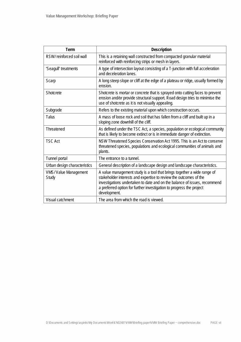
Glossary of terms and abbreviations Term Description
100-year ARI flood event Refers to the flood event that occurs, on average, once every 100 years. Also known as the 100-year Average Recurrence Interval of a flood. These events are of a random nature. It is possible to have 100-year floods in successive years. Similarly a 100-year flood event may not occur for 200 years and may not be the largest flood in the last 100 years. This also applies to 5-year and 20-year ARI flood events.
AADT/ Annual Average Daily Traffic
The total traffic in both directions at a specified location calculated from mechanically obtained axle counts.
Acid sulphate rock Rock that contains sufficient sulphide minerals to pose an environmental and/or corrosion risk when excavated or where in contact with structures.
AEP Annual Exceedance Probability
The probability of a rainfall or flood event exceeding a nominated level in a year. A 1% AEP is the probability of an event exceeding a nominated level in 100 years.
Afflux An increase in water level resulting from additional obstacles in the flow path. AHD Australian Height Datum The standard reference level used to express the relative height of various
features. A height given in metres AHD is essentially the height above sea level.
AHIMS Aboriginal Heritage Information Management System. Amenity The degree of pleasantness of an area or place. Alignment The general route (e.g. of a roadway) in plan and elevation. Arboreal To live in, or be connected with, trees. Archaeological site A site with any material evidence of past Aboriginal activity that remains
within a context or place that can be reliably related to that activity. ARL/ Assess risk level A rating of risk to life and property due to slope instability (e.g. rock falls and
landslides). The rating is between 1 (highest risk) and 5 (lowest risk) and is given to individual cuttings and fill embankments based on the size and rapidity of failure, the failure’s likely degree of impact on life and property and the probability of that impact occurring. The desirable target for new roads is ARL 4.
Asphalt or asphaltic concrete or AC
A dense, continuously graded mixture of coarse and fine aggregates, mineral filler and bitumen usually produced hot in a mixing plant.
ASS/ Acid sulphate soils Naturally acid clays, mud and other sediments usually found in swamps and estuaries. They may become extremely acidic when drained and exposed to oxygen, and may produce acidic leachate and run-off that can pollute receiving waters and liberate toxins. ASS are classified as materials which are above the groundwater, are undergoing oxidation and have a pH of less than 4.0.
Background noise level The ambient sound pressure noise level in the absence of the sound under investigation exceeded for 90 per cent of the measurement period. Normally equated to the average minimum A-weighted sound pressure level.

Value Management Workshop: Briefing Paper
D:\Documents and Settings\aspinks\My Documents\Work\EN02481\VMW\Briefing paper\VMW Briefing Paper ~ comprehensive.doc PAGE v
Term Description Batter The side slope of walls, embankments and cuttings or the degree of such
slope, usually expressed as a ratio of horizontal distance to one vertical height.
Borehole A hole produced in the ground by drilling for the investigation and assessment of soil and rock profiles.
Cantilever bridge Bridge built using cantilevers ie structures that project horizontally into space, supported on only one end. In a balanced cantilever bridge the cantilever span is counterbalanced with another cantilever arm projecting in the opposite direction.
Carriageway The portion of a roadway devoted to vehicular traffic generally delineated by kerbs, a verge or a median.
Catchment The area drained by a stream or body of water, or the area of land from which water is collected.
Concept design Initial functional layout of a concept, such as a road or road system, to provide a level of understanding to later establish detailed design parameters.
Culvert An enclosed channel for conveying a stream below a road. Cutting A formation resulting from the construction of the road below the existing
ground level after material is cut out or excavated. dBA Decibels using the A-weighted scale. Decibels are used to measure sound
levels. dBA measures loudness according to the human perception of sound. DECCW NSW Department of Environment, Climate Change and Water. Decibel Decibels are used to measure sound levels. Design speed A nominal speed used in designing a road’s geometric features (such as
curves). Earthworks The process of extracting, moving and depositing earth during construction. Earthwork balance The relative volumes of materials excavated from cuttings and materials
placed in fill embankments. A road design generally targets equal volumes of cut and fill materials, hence giving balanced earthworks.
EEC Endangered ecological community. An ecological community identified by relevant legislation as having endangered status.
EIA Environmental impact assessment. Embankment A mound or bank of earth or stone formed to support a roadway incorporating
sloping/battered faces. EP&A Act Environmental Planning and Assessment Act 1979 (NSW). EPBC Act Environment Protection and Biodiversity Conservation Act 1999
(Commonwealth). Flood immunity Relates to the level at which a particular structure would be clear of a certain
flood event. A project objective is to provide flood immunity on at least one carriageway between 1% AEP (target) and 20% AEP (absolute minimum).

Value Management Workshop: Briefing Paper
D:\Documents and Settings\aspinks\My Documents\Work\EN02481\VMW\Briefing paper\VMW Briefing Paper ~ comprehensive.doc PAGE vi
Term Description Geological unit A volume of rock of identifiable origin and age range that is readily mapped,
such as a series of interbedded sandstone and claystone beds or a body of granite.
Geotech/ geotechnology Application of the methods of engineering and science to construction that involves natural soil and rock materials.
GIS Geographical information system. Grade/ gradient Slope or steepness. Grade separation The use of an underpass and overpass to separate road, rail or other traffic
that cross each other, so that crossing movements do not conflict. Habitat The place where an organism lives. Habitats are measurable and can be
described by their flora and physical components. HV Heavy vehicle. H:V The ratio of horizontal distance to: vertical height, which is the expression of
slope generally used when referring to batters. Interchange A grade-separated junction between roads where the local road passes
above or beneath the highway via a bridge or underpass structure. Traffic joins and leaves the highway via exit and entry ramps. Traffic on both the local road and the proposed upgrade can move freely without interrupting traffic on the other road.
Intersection A junction between roads where the connection is made at the same level (grade). Traffic on the connecting road has to wait for a gap in the through road to join or cross that road. These are the types of junctions that exist between local roads and the existing Great Western Highway.
LALC Local Aboriginal land council. LEP Local environmental plan. Longitudinal section or ‘long section’
The section drawn along the length of the route showing vertical elevation.
MVKT Million vehicle kilometres travelled. PAD/ Potential archaeological deposit
Any location considered to have a moderate to high potential for subsurface archaeological material.
Posted speed Sign-posted speed limit. Can be different to the design speed. Rock anchor Rock anchors are used to stabilise large volumes of rock. They may be used
in viaduct construction to anchor piers and can also be used in retaining structures. Rock anchors are generally 10m to 30m long, and made from wire rope or steel bar. They are cement-grouted at the down hole end and then stressed with hydraulic jacks.
Rock bolt Rock bolts are used to stabilise blocks of rock in cutting batters. They generally comprise a galvanised steel bar, 2m to 6m long, which is cement-grouted into a drill hole.
RL/ relative level The relative level is measured to Australian Height Datum (AHD). Zero metres AHD is approximately mean sea level.
Value Management Workshop: Briefing Paper
D:\Documents and Settings\aspinks\My Documents\Work\EN02481\VMW\Briefing paper\VMW Briefing Paper ~ comprehensive.doc PAGE vii
Term Description RSW/ reinforced soil wall This is a retaining wall constructed from compacted granular material
reinforced with reinforcing strips or mesh in layers. ‘Seagull’ treatments A type of intersection layout consisting of a T-junction with full acceleration
and deceleration lanes. Scarp A long steep slope or cliff at the edge of a plateau or ridge, usually formed by
erosion. Shotcrete Shotcrete is mortar or concrete that is sprayed onto cutting faces to prevent
erosion and/or provide structural support. Road design tries to minimise the use of shotcrete as it is not visually appealing.
Subgrade Refers to the existing material upon which construction occurs. Talus A mass of loose rock and soil that has fallen from a cliff and built up in a
sloping zone downhill of the cliff. Threatened As defined under the TSC Act, a species, population or ecological community
that is likely to become extinct or is in immediate danger of extinction. TSC Act NSW Threatened Species Conservation Act 1995. This is an Act to conserve
threatened species, populations and ecological communities of animals and plants.
Tunnel portal The entrance to a tunnel. Urban design characteristics General description of a landscape design and landscape characteristics. VMS/ Value Management Study
A value management study is a tool that brings together a wide range of stakeholder interests and expertise to review the outcomes of the investigations undertaken to date and on the balance of issues, recommend a preferred option for further investigation to progress the project development.
Visual catchment The area from which the road is viewed.

Value Management Workshop: Briefing Paper
PAGE 1
1. Introduction 1.1. Background
Project overview
The Australian and NSW governments, together with the community, are investigating an area between Mount Victoria and Lithgow to determine the preferred route for an upgrade of the Great Western Highway. The highway upgrade project is part of both governments’ commitment to improve road safety and accessibility for communities in the Blue Mountains and Central West.
The study area for the proposed upgrade extends along an 18.4 kilometre section of the Great Western Highway from the western end of the Soldiers Pinch road-widening project near Browntown Oval at Mount Victoria to one kilometre west of McKanes Falls Road at South Bowenfels, south of Lithgow. This section of highway is used by Blue Mountains and Lithgow residents for local trips as well as to access communities in the Central West. However, it has a disproportionate number of serious and fatal crashes due to its poor alignment, geometry and grades.
The project has formed part of a number of major planning studies, including the Penrith to Orange Transport Strategy (1998), the Sydney–Dubbo Corridor Strategy (2007) and the Central West Transport Needs Study (2009).
Project objectives
The objectives of the project are to: Improve road safety. Improve road freight efficiency. Cater for the mix of through, local and tourist traffic. Be sensitive to the area’s natural environment, heritage and local communities.
Strategic and project need
The Great Western Highway is an important access route between Sydney and the Central West of NSW. The highway upgrade work that has already been completed has led to improved travel times for motorists and a safer road environment for all motorists, pedestrians and cyclists. These improvements support the position of the Australian and NSW governments to continue to upgrade the highway.
The proposed Mount Victoria to Lithgow highway upgrade is consistent with the governments’ strategic priorities of improving the highway’s safety performance and efficiency, and would help meet road network needs. In particular, the upgrade is required to:
Improve road safety. Improve travel speeds and improve level of service.

Value Management Workshop: Briefing Paper
D:\Documents and Settings\aspinks\My Documents\Work\EN02481\VMW\Briefing paper\VMW Briefing Paper ~ comprehensive.doc PAGE 2
Improve freight efficiency. Improve access to the Central West of NSW to support growth in this region. Reduce road-user costs. Better cater for the mix of local, through and tourist traffic. Address the social and environmental impacts of through traffic. Fully realise the value of public investment in the Great Western Highway upgrade program to date.
Planning to date
Selecting a preferred route for the highway upgrade will involve seven main stages:
Project announcement (May 2008). Study area investigations (investigations commenced May 2008). Initial corridor development, leading to the selection of five corridors in which routes may be feasible
(corridors announced November 2008). Confirmation of four corridors (corridors announced April 2009). Development and selection of a preferred corridor (preferred corridor announced August 2009). Development of route options – this report (route options announced October 2009). Preferred route selection (expected to be finalised in first quarter of 2010).
The project is now at the ‘preferred route selection’ stage.
1.2. Purpose of Value Management Workshop
A preferred option has not been selected at this stage. The preferred route must provide a balance across social, environmental and functional issues to meet project objectives, taking costs and community values into consideration. The value management workshop is one of several inputs to the consideration of a preferred route.
The purpose of the value management workshop is to discuss the route options and gain a shared understanding of which options provide the best balance across social, environmental, economic and engineering issues. The workshop will consider outcomes of the community and stakeholder consultation process undertaken to date, along with the outcomes of the technical, environmental and other specialist studies. The workshop includes participants from the local community, government agencies, councils, the transport industry and environmental, Aboriginal, business and other stakeholders.
The agenda for the Value Management Workshop is provided over the page.

Value Management Workshop: Briefing Paper
D:\Documents and Settings\aspinks\My Documents\Work\EN02481\VMW\Briefing paper\VMW Briefing Paper ~ comprehensive.doc PAGE 3
Day 1: 25th November 2009
Time Item 8.45 Coffee and informal chat 9.00 Welcome and introduction by RTA Project Director 9.05 Introduction to methodology and group problem solving 9.25 Strategic diagnosis outcomes (scoping) 9.30 Introduction to Link Thinking 9.35 Critical Criteria Presentations (information stage) 10.30 Break 10.45 Introduction to structured questions 10.55 Structured Q&A session 12.00 Final option list presented and arrived at 12.30 Evaluation criteria
1) Final list 2) Definitions by consensus
1.00 Lunch 1.45 Evaluation criteria weighting 2.15 Sensitivity test criteria weightings (in groups) 3.00 Option rating 3.30 Break and informal questioning 4.00 Ranking (with discussion) to create consensus rank 5.00 Final discussion (in groups) 5.15 Final discussion (full group) 5.45 Finish
Day 2: 26th November 2009
Time Item 9.00 Coffee and informal chat 9.30 Sensitivity testing of evaluation matrix (in groups) 10.00 Sensitivity testing of evaluation matrix (full group) and value ratio’s 10.30 Break 11.00 Consensus discussion and final decision on ranking of options (full group) 12.30 Lunch 1.15 Refinement of options/hybrid option investigation (in groups) 2.00 Full group discussion 3.00 Break 3.15 Action plan items for RTA 4.00 Next steps 4.30 Finish

Value Management Workshop: Briefing Paper
D:\Documents and Settings\aspinks\My Documents\Work\EN02481\VMW\Briefing paper\VMW Briefing Paper ~ comprehensive.doc PAGE 4
1.3. Purpose of this briefing document
This briefing document provides an overview of the various route options developed to date for the Mount Victoria to Lithgow upgrade project. It highlights the key technical, environmental and social issues associated with each of these options, and summarises the various community comments received in response to the display of these route options. The purpose of the briefing document is to facilitate the route option value management study and in particular the workshop to be held on 25 and 26 November 2009 by ensuring that participants have sufficient background information to engage meaningfully in the value management process.
This paper is divided into five sections:
Section 2 – General information, including a description of the route development process. Section 3 – Description of the key attributes associated with the Mount Victoria sub-options. Section 4 – Description of the key attributes associated with the Harp of Erin/ Ambermere sub-options. Section 5 – Description of the key attributes associated with the River Lett Hill sub-options. Section 6 – Description of the key attributes associated with the Forty Bends sub-options.

Value Management Workshop: Briefing Paper
D:\Documents and Settings\aspinks\My Documents\Work\EN02481\VMW\Briefing paper\VMW Briefing Paper ~ comprehensive.doc PAGE 5
2. General 2.1. Development of route options
On 27 August 2009, the Minister for Roads announced that the plans for the upgrade of the Great Western Highway between Mount Victoria and Lithgow would concentrate solely on the corridor along the existing highway, known as the orange corridor. The development of route options involved a number of inputs, including community submissions and involvement in workshops, field investigations and engineering design. The approach to the development of route involved the following (refer to Figure 2-1):
Review of confirmed corridor: The first step of the process involved a review of the confirmed corridor to ensure an understanding of the bounds within which route options could be developed, and to identify the key features associated with the corridor.
Review of topography within confirmed corridor: Topography plays the key role in route option development as it has implications for grades, earthwork requirements and the type and size of structures. Accordingly, a review of the contours within the confirmed corridor enabled the identification of the initial route options that best addressed the prevailing topography from a technical perspective, while satisfying the design objectives and criteria.
Development of route options: Based on the review of the topography, initial route options were developed that provided the best result in terms of the design criteria, grades, earthworks, structures and constructability.
Refinement of route options: The initial route options were then refined taking into consideration the suite of geotechnical, urban design, environmental and socio-economic considerations. The route options developed during the Community Route Option Workshop days were reviewed as part of this route refinement process. Any gaps in the constraint information were considered and, where possible, flagged and recorded as issues for further consideration during subsequent phases of the route development process. The refined route options were then re-checked against the design criteria and objectives to ensure they were feasible.
Technical workshops: Workshops with the broader project team were held on 28–29 July 2009 and 4 August 2009 to review and confirm the route options that had been developed. Attendees had expertise in environmental planning, socio-economic assessment, Aboriginal and non-Aboriginal heritage, urban design, biodiversity, community consultation, road design and engineering, geotechnical design and property acquisition. The route options were examined to identify opportunities for innovation, flexibility and ways to avoid or minimise impacts on key issues; and to ensure the route options addressed the issues raised during community consultation.

Value Management Workshop: Briefing Paper
D:\Documents and Settings\aspinks\My Documents\Work\EN02481\VMW\Briefing paper\VMW Briefing Paper ~ comprehensive.doc PAGE 6
Figure 2-1 Route options development process (from announcement of confirmed corridor)

Value Management Workshop: Briefing Paper
D:\Documents and Settings\aspinks\My Documents\Work\EN02481\VMW\Briefing paper\VMW Briefing Paper ~ comprehensive.doc PAGE 7
Quantm: Internal design reviews and analysis using the Quantm computer model were carried out in parallel with the route options development process. Quantm is a computer program used as part of the early planning to identify and analyse feasible route options. This program helps to ensure that the route options being considered are viable and would minimise the impact on the environment and the community. The Quantm and design review process enabled the route options and assumptions to be tested and also provided alternative options and innovations for consideration.
Design criteria
The design criteria used in the design of the route options included:
Minimum design speed: 90 kilometres per hour at the eastern end and western ends, and 110 kilometres per hour across the valley floor.
Minimum horizontal radii: 350 metres at the eastern and western ends, and 600 metres across the valley floor.
Minimum vertical curve: A sag of 26 and crest of 32 at the eastern and western ends, and a sag of 34 and crest of 95 across the valley floor.
Description of route options and sub-options
Route options were developed using the methodology outlined above. These route options include various sub-options at four locations (refer to map at end of section):
1) Mount Victoria: a) Outer bypass. b) Inner bypass. c) Long tunnel.
2) Harp of Erin/ Ambermere: a) Current alignment. b) Bypass.
3) River Lett Hill: a) Northern alignment. b) Southern alignment.
4) Forty Bends: a) Current alignment. b) Straight alignment
These sub-options are described in more detail in the following sections.
2.2. Constructability considerations
The following comments are general constructability considerations and are applicable for the whole project site:
The locations of traffic connections are critical for Occupational Health and Safety (OHS) reasons. In general, these would preferably not be located on crests or curves
Construction on a greenfield site would be easier to manage.

Value Management Workshop: Briefing Paper
D:\Documents and Settings\aspinks\My Documents\Work\EN02481\VMW\Briefing paper\VMW Briefing Paper ~ comprehensive.doc PAGE 8
From an OHS perspective, a major consideration in design would be clearances from the 132kv powerline which runs parallel to the Great Western Highway in the region of River Lett Hill/ Fernhill.
Wherever appropriate, the upgrade should maximise the use of the existing highway alignment for future service roads/accesses.

Value Management Workshop: Briefing Paper
PAGE 9

Value Management Workshop: Briefing Paper
D:\Documents and Settings\aspinks\My Documents\Work\EN02481\VMW\Briefing paper\VMW Briefing Paper ~ comprehensive.doc PAGE 10

Value Management Workshop: Briefing Paper
D:\Documents and Settings\aspinks\My Documents\Work\EN02481\VMW\Briefing paper\VMW Briefing Paper ~ comprehensive.doc PAGE 11

Value Management Workshop: Briefing Paper
D:\Documents and Settings\aspinks\My Documents\Work\EN02481\VMW\Briefing paper\VMW Briefing Paper ~ comprehensive.doc PAGE 12

Value Management Workshop: Briefing Paper
PAGE 13
3. Mount Victoria sub-options 3.1. Description of route options
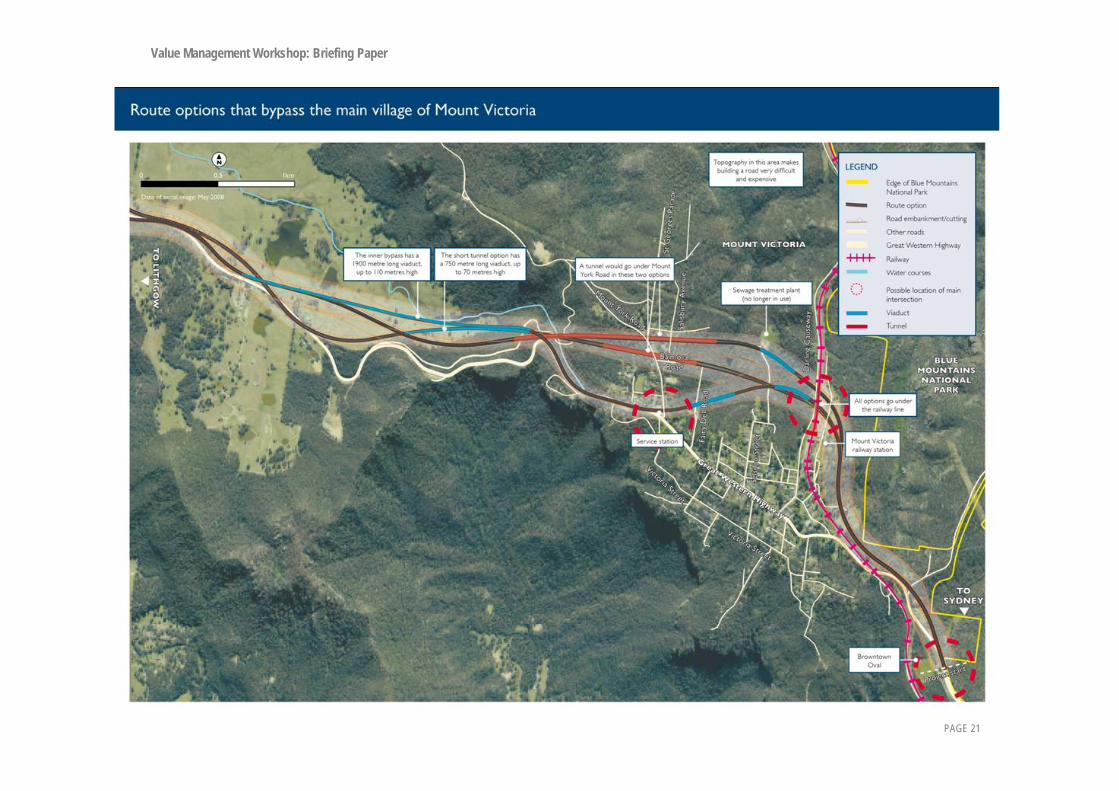
Three sub-options have been identified in Mount Victoria, extending from immediately west of the railway to about one kilometre beyond the bottom of Victoria Pass (refer to map at end of section):
Mount Victoria long tunnel bypass. Mount Victoria outer bypass. Mount Victoria inner bypass.
These sub-options are described below.
Mount Victoria long tunnel bypass This sub-option would begin at the crossing of the railway, following the most northerly route of the three sub-options through Mount Victoria, allowing it to avoid the curtilage of The Grange. A viaduct 250 metres long would be required to span the Fairy Dell Creek gully. The alignment would pass under the Mount York ridge in a 1.3 kilometre-long tunnel. The tunnel would follow a five per cent grade, emerging on Mitchells Pass Ridge, immediately to the west of the route of Berghofers Pass. It would then swing slightly to the south onto the footslopes of Mount Victoria in order to negate the need for a viaduct between the western tunnel portal and the valley floor. At the foot of Victoria Pass the alignment would traverse to the north to join the route of the Mount Victoria Inner Bypass sub-option, which it would follow to the west until the three sub-options converge in Little Hartley.
Mount Victoria outer bypass The alignment of this sub-option would begin at the crossing of the railway and would follow the southern edge of the modified orange corridor along a route to the south of the Mount Victoria long tunnel bypass. The main factor dictating the location of the alignment is the position of the tunnel, which would be sited under the saddle that runs along Mount York Road to minimise the tunnel length. The tunnel would be about 600 metres long. The other controlling factor would be the location of the railway underpass, which would be positioned to minimise effects on the existing railway lines and avoid, where possible, the curtilage of the historic railway buildings. A large dam and the sewage treatment works would be avoided, but there would be greater affect on the curtilage of The Grange.
From the western portal of the tunnel, the alignment would move as close as possible to the existing Victoria Pass, which would allow the length and height of the viaduct to the valley floor to be minimised. At an eight per cent grade, the viaduct would be 750 metres long with a maximum height of 70 metres. The alignment would therefore avoid the historic Mount Victoria convict stockade and the talus slopes, which are potentially unstable. The alignment would also cross Berghofers Pass. An option with a six per cent grade was also investigated, but was screened out as it required a 2.4 kilometre long viaduct.

Value Management Workshop: Briefing Paper
D:\Documents and Settings\aspinks\My Documents\Work\EN02481\VMW\Briefing paper\VMW Briefing Paper ~ comprehensive.doc PAGE 14
An intersection with the existing highway would need to be considered at the bottom of Victoria Pass to allow vehicles prohibited from entering the tunnel to rejoin the highway.
Mount Victoria inner bypass The inner bypass would diverge from the other sub-options to the east of the railway, where it would pass under the railway and follow an alignment further to the south of the other alignments. This sub-option alignment would bisect the curtilage of The Grange and would cross two deep gullies on viaducts before meeting Mount York Road at grade. The Caltex service station, located at the Mount York Road junction, would need to be acquired. The alignment would then follow the route of the existing highway as far as the top curve on Victoria Pass, where it would then diverge to the north. From this point, a viaduct 1.9 kilometres long and up to 110 metres high would be required at an eight per cent grade to take the highway to the valley floor. The alignment would be located to the north to avoid houses on the existing highway at the bottom of the pass. The viaduct would then pass over the historic Mount Victoria convict stockade and Berghofers Pass.
3.2. Summary of technical, environmental and social considerations
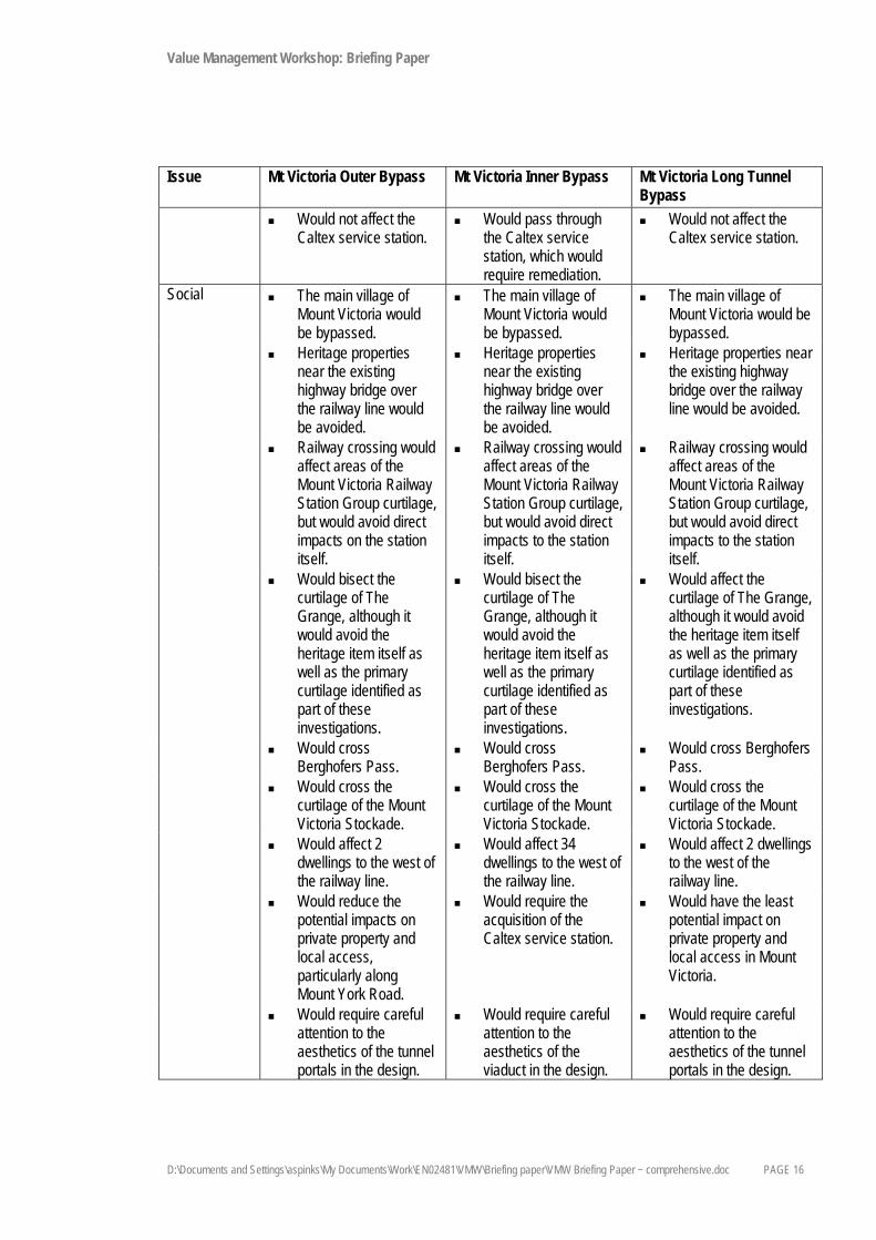
Issue Mt Victoria Outer Bypass Mt Victoria Inner Bypass Mt Victoria Long Tunnel Bypass
Technical Would have a maximum grade of 8%.
Would have a maximum grade of 8%.
Would have a maximum grade of 5%.
Horizontal and vertical alignment of the highway would be improved.
Horizontal and vertical alignment of the highway would be improved.
Horizontal and vertical alignment of the highway would be improved.
Would require large fill within the gully to the west of the railway station.
Would require large fill within the gully to the west of the railway station.
A lower underpass below the railway line than the outer bypass would be needed.
Would require large fill within the gully to the west of the railway station.
A 750 m long, 70 m high viaduct to the valley floor would be required.
2 viaducts through the Grange would be required.
Would require a viaduct to the valley floor, 1.9 km long, 110 m high.
A 250 m long viaduct over Fairy Dell Creek would be required
Would not require a viaduct between the tunnel portal and the valley floor.
The dam and sewage treatment plant would be avoided.
The dam and sewage treatment plant would be avoided.
The dam and sewage treatment plant would be avoided.

Value Management Workshop: Briefing Paper
D:\Documents and Settings\aspinks\My Documents\Work\EN02481\VMW\Briefing paper\VMW Briefing Paper ~ comprehensive.doc PAGE 15
Issue Mt Victoria Outer Bypass Mt Victoria Inner Bypass Mt Victoria Long Tunnel Bypass
Would carry geological risks associated with the construction of the tunnel.
Would require excavation of a rock outcrop at the top of Victoria Pass.
Geological risks associated with construction of a tunnel would be avoided.
Would carry geological risks associated with construction of a tunnel.
Length of the tunnel would require an alternative route for vehicles carrying Class 1 and 2 dangerous goods.
Would not impose restrictions on the types of dangerous goods that can be transported.
Length of the tunnel would require an alternative route for vehicles carrying Class 1 and 2 dangerous goods
Would have greater construction and operation costs than the inner bypass sub-option as it would include a 600 m long tunnel.
Would avoid the construction and operation costs associated with a tunnel.
Would have the greatest construction and operation costs as it would include a 1.3 km long tunnel.
Environmental Direct impacts on Blue Mountains National Park and World Heritage Area could be avoided if a retaining wall were constructed.
Direct impacts on Blue Mountains National Park and World Heritage Area could be avoided if a retaining wall were constructed.
Direct impacts on Blue Mountains National Park and World Heritage Area could be avoided if a retaining wall were constructed.
Would affect 3 ha of endangered ecological communities.
Would affect less than 0.1 ha of endangered ecological communities.
Would affect 2 ha of endangered ecological communities.
Would affect 7 ha of very high and 20 ha of high conservation value vegetation.
Would affect less than 5 ha of very high and 20 ha of high conservation value vegetation.
Would affect 6 ha of very high and 15 ha of high conservation value vegetation.
The DECCW wildlife corridor would be bisected.
The DECCW wildlife corridor would be bisected.
The DECCW wildlife corridor would be bisected.
Would affect localised areas of high-velocity flow.
Would not affect areas of high-velocity flow.
Would affect localised areas of high-velocity flow.
Would affect localised waterlogged area on the valley floor.
Would affect localised waterlogged area on the valley floor.
Would not affect localised waterlogged areas on the valley floor.
Value Management Workshop: Briefing Paper
D:\Documents and Settings\aspinks\My Documents\Work\EN02481\VMW\Briefing paper\VMW Briefing Paper ~ comprehensive.doc PAGE 16
Issue Mt Victoria Outer Bypass Mt Victoria Inner Bypass Mt Victoria Long Tunnel Bypass
Would not affect the Caltex service station.
Would pass through the Caltex service station, which would require remediation.
Would not affect the Caltex service station.
Social The main village of Mount Victoria would be bypassed.
The main village of Mount Victoria would be bypassed.
The main village of Mount Victoria would be bypassed.
Heritage properties near the existing highway bridge over the railway line would be avoided.
Heritage properties near the existing highway bridge over the railway line would be avoided.
Heritage properties near the existing highway bridge over the railway line would be avoided.
Railway crossing would affect areas of the Mount Victoria Railway Station Group curtilage, but would avoid direct impacts on the station itself.
Railway crossing would affect areas of the Mount Victoria Railway Station Group curtilage, but would avoid direct impacts to the station itself.
Railway crossing would affect areas of the Mount Victoria Railway Station Group curtilage, but would avoid direct impacts to the station itself.
Would bisect the curtilage of The Grange, although it would avoid the heritage item itself as well as the primary curtilage identified as part of these investigations.
Would bisect the curtilage of The Grange, although it would avoid the heritage item itself as well as the primary curtilage identified as part of these investigations.
Would affect the curtilage of The Grange, although it would avoid the heritage item itself as well as the primary curtilage identified as part of these investigations.
Would cross Berghofers Pass.
Would cross Berghofers Pass.
Would cross Berghofers Pass.
Would cross the curtilage of the Mount Victoria Stockade.
Would cross the curtilage of the Mount Victoria Stockade.
Would cross the curtilage of the Mount Victoria Stockade.
Would affect 2 dwellings to the west of the railway line.
Would affect 34 dwellings to the west of the railway line.
Would affect 2 dwellings to the west of the railway line.
Would reduce the potential impacts on private property and local access, particularly along Mount York Road.
Would require the acquisition of the Caltex service station.
Would have the least potential impact on private property and local access in Mount Victoria.
Would require careful attention to the aesthetics of the tunnel portals in the design.
Would require careful attention to the aesthetics of the viaduct in the design.
Would require careful attention to the aesthetics of the tunnel portals in the design.

Value Management Workshop: Briefing Paper
D:\Documents and Settings\aspinks\My Documents\Work\EN02481\VMW\Briefing paper\VMW Briefing Paper ~ comprehensive.doc PAGE 17
3.3. Additional geotechnical information
Issue Mt Victoria Outer Bypass Mt Victoria Inner Bypass Mt Victoria Long Tunnel Bypass
Rail underpass
Cutting under railway in extremely low to medium strength sandstone may need retaining.
Abutments piled. Cut material may be
suitable for retaining wall fill.
Cutting under railway in extremely low to medium strength sandstone may need retaining.
Abutments piled. Cut material may be
suitable for retaining wall fill.
Cutting under railway in extremely low to medium strength sandstone may need retaining.
Abutments piled. Cut material may be
suitable for retaining wall fill.
Viaducts east of Mount York Road
Good foundation conditions for viaducts and embankments over two valleys west of railway.
Difficult access into steep valleys for construction.
Good foundation conditions for viaducts and embankments over two valleys west of railway.
Difficult access into steep valleys for construction.
Good foundation conditions for viaducts and embankments over two valleys west of railway.
Difficult access into steep valleys for construction.
Darling Causeway Underpass
15m cut. At grade. 12m cut. Bankswall sandstone,
abutments piled, cuts retained.
Bankswall sandstone, abutments piled, cuts retained.
Tunnel Fairly good portal and tunnelling conditions in good quality sandstone and reasonable claystone.
Deep cut (42m deep) after west portal - consider further short tunnel.
No tunnel. Good quality sandstone at eastern portal and 40% of tunnel.
Western portal in weaker, weathered rock and talus difficult to construct.
60% of tunnel in more fractured, interbedded rock would require more roof support.
Possibility of coal seams and or gas in western half of tunnel. If present, gas can be managed during construction.
Line tunnel to eliminate long term gas risk.
Rockfall hazard at western portal.

Value Management Workshop: Briefing Paper
D:\Documents and Settings\aspinks\My Documents\Work\EN02481\VMW\Briefing paper\VMW Briefing Paper ~ comprehensive.doc PAGE 18
Issue Mt Victoria Outer Bypass Mt Victoria Inner Bypass Mt Victoria Long Tunnel Bypass
Difficult access to eastern portal for construction would require construction of a haulage road.
Difficult access to eastern portal for construction would require construction of a haulage road.
Difficult access to western portal.
Access to western portal via section of highway constructed first.
Viaducts Deep, costly viaduct foundations in poor quality rock. Difficult access to two eastern-most piers.
Deep, costly viaduct foundations in poor quality rock. Difficult access to two eastern-most piers.
Embankment west of tunnel on talus slope would require stabilisation of foundations.
Rockfalls Rock fall hazard for 200m section west of tunnel needs to be addressed in design.
Rock fall hazard for 200m section west of tunnel needs to be addressed in design.
Rock fall risk to viaduct piers can be managed.
Rock fall risk to viaduct piers can be managed.
3.4. Constructability considerations
Mt Victoria Outer Bypass Mt Victoria Inner Bypass Mt Victoria Long Tunnel Bypass Staging is not an option Option available of staging
construction east and west of Mt York Rd
Staging is not an option.
Tunnel east/west orientation would require consideration of sunlight issues.
No tunnel required. Tunnel east/west orientation would require consideration of sunlight issues.
Difficult ground conditions likely at eastern and western portals for construction and access.
No tunnel required. Less difficult ground conditions at western portal, difficult ground conditions at eastern portal for construction and access.
Short tunnel (600m) would require 2MW of available power load and 100000 litres of available stored water for ongoing operational needs.
No tunnel required. Long tunnel (1300m) would require 3MW of available power load and 100000 litres of available stored water for ongoing operational needs.
Design and method of construction of 750m viaduct at a grade of 7-8% would require specialist advice.
Design and method of construction of 1.9km viaduct at a grade of 7-8% would require specialist advice.
No long viaduct structures required.

Value Management Workshop: Briefing Paper
D:\Documents and Settings\aspinks\My Documents\Work\EN02481\VMW\Briefing paper\VMW Briefing Paper ~ comprehensive.doc PAGE 19
Mt Victoria Outer Bypass Mt Victoria Inner Bypass Mt Victoria Long Tunnel Bypass OHS issues with construction
and ongoing maintenance of 70m high viaduct.
OHS issues with construction and ongoing maintenance of 110m high viaduct.
No long viaduct structures required.
Consideration of undercutting Victoria Pass required below first bend.
Potential difficulty commencing construction of long viaduct and earthworks adjacent to the first bend of Victoria pass.
In tunnel zone at this location.
Fill disposal from tunnel to other sections of project difficult.
Fill less of issue due to lack of tunnel.
Large amount of fill to dispose of, large proportion possibly unsuitable for reuse on project.
Rural tunnel may need additional height clearance, tunnel excavation may need to be benched.
No tunnel required. Rural tunnel may need additional height clearance, tunnel excavation may need to be benched.
Access tracks for viaduct piers in talus would be difficult and require temporary retention.
Access tracks for viaduct piers in talus would be difficult and require temporary retention.
No large viaducts.
No long side cut in talus. No long side cut in talus. Long side cut in talus may require retention structures.

Value Management Workshop: Briefing Paper
PAGE 21

Value Management Workshop: Briefing Paper
D:\Documents and Settings\aspinks\My Documents\Work\EN02481\VMW\Briefing paper\VMW Briefing Paper ~ comprehensive.doc PAGE 22

Value Management Workshop: Briefing Paper
D:\Documents and Settings\aspinks\My Documents\Work\EN02481\VMW\Briefing paper\VMW Briefing Paper ~ comprehensive.doc PAGE 23

Value Management Workshop: Briefing Paper
D:\Documents and Settings\aspinks\My Documents\Work\EN02481\VMW\Briefing paper\VMW Briefing Paper ~ comprehensive.doc PAGE 24

Value Management Workshop: Briefing Paper
PAGE 25
4. Little Hartley sub-options 4.1. Description of route options
Almost immediately after where the Mt Victoria sub-options would converge, the route would split again into two sub-options, the Harp of Erin/ Ambermere current alignment and the Harp of Erin/ Ambermere bypass (refer to map at end of section). This split would occur approximately 600 metres east of Coxs River Road. These sub-options are discussed below.
Harp of Erin/ Ambermere current alignment The alignment of this sub-option would follow the route of the existing Great Western Highway, avoiding Rosedale, Noika and The Log Cabin, passing between Ambermere and the Harp of Erin. A four-lane upgrade along this alignment would impact the Harp of Erin and Ambermere, but a two-lane upgrade could likely be accommodated without affecting these heritage buildings.
Harp of Erin/ Ambermere bypass This sub-option would deviate to the south of the common alignment about 600 metres east of Coxs River Road, passing through Little Hartley and then reconnecting to the common alignment about 500 metres west of Coxs River Road. It would avoid impacts on the Harp of Erin, Ambermere and the Log Cabin, but would directly affect various dwellings, some sheds and business premises, including the airstrip.
4.2. Summary of technical, environmental and social considerations
Issue Harp of Erin/ Ambermere Current Alignment Harp of Erin/Ambermere Bypass Technical Would have a maximum grade of 5.8%. Would have a maximum grade of 5.8%. Horizontal and vertical alignments of
the highway would be improved. Horizontal and vertical alignments of the
highway would be improved. Environmental Would require limited vegetation
removal, although it would affect 2 ha of very high conservation value vegetation.
Would affect 3 ha of very high conservation value vegetation.
Little Hartley airfield would not be affected.
Would be located close to the Little Hartley airfield, which has been identified as a potential contaminated site.
Social A 2-lane road only could be accommodated without affecting the Harp of Erin or Ambermere.
Would avoid the need to relocate the Harp of Erin.
Would avoid Ambermere and Billesdene Grange.

Value Management Workshop: Briefing Paper
D:\Documents and Settings\aspinks\My Documents\Work\EN02481\VMW\Briefing paper\VMW Briefing Paper ~ comprehensive.doc PAGE 26
Issue Harp of Erin/ Ambermere Current Alignment Harp of Erin/Ambermere Bypass Ambermere, the Harp of Erin,
Rosedale, Billesdene Grange and The Log Cabin would be affected.
Harp of Erin, Rosedale and The Log Cabin would be affected.
Alternative access for the aforementioned heritage items would be required.
Would alter the historic context of the heritage items in relation to servicing the highway.
Would affect 10 dwellings. Would affect 8 dwellings. Would affect 16 ha of Class 3
agricultural land. Would affect 14 ha of Class 3
agricultural land. Would affect 14 ha of land zoned for
rural residential use. Would affect 15 ha of land zoned for
rural residential use. Severing the new subdivisions on the
western side of the existing highway would be avoided.
The creation of new impacts and the severance of existing housing clusters would be minimised.
Implications for local business/tourism would be minimised.
Would result in the creation of an ‘island’ surrounded by major roadways.
Would expose the residents located to the south of the existing highway to greater noise impacts and those to the north of the highway to reduced noise impacts.
Construction of an alternative intersection with Coxs River Road would be required.
Would affect the use of the Little Hartley airfield.
4.3. Additional geotechnical information
Harp of Erin/Ambemere Current Alignment Harp of Erin/Ambermere Bypass No deep cut required. A 14 m deep cutting near start of bypass may
intersect a small quantity of acid sulphate rock.
4.4. Constructability considerations
Harp of Erin/Ambemere Current Alignment Harp of Erin/Ambermere Bypass Construction under traffic difficult. Greenfield site is easier and safer. Proximity of heritage properties would create
construction issues of noise and vibration for both excavation and compaction.
Bypass option would be located further away from heritage properties.
Realignment of Cox’s River Rd and Ambermere Drive intersections would be required.
Realignment of Cox’s River Rd and Ambermere Drive intersections would be required

Value Management Workshop: Briefing Paper
PAGE 27

Value Management Workshop: Briefing Paper
D:\Documents and Settings\aspinks\My Documents\Work\EN02481\VMW\Briefing paper\VMW Briefing Paper ~ comprehensive.doc PAGE 28

Value Management Workshop: Briefing Paper
D:\Documents and Settings\aspinks\My Documents\Work\EN02481\VMW\Briefing paper\VMW Briefing Paper ~ comprehensive.doc PAGE 29

Value Management Workshop: Briefing Paper
D:\Documents and Settings\aspinks\My Documents\Work\EN02481\VMW\Briefing paper\VMW Briefing Paper ~ comprehensive.doc PAGE 30

Value Management Workshop: Briefing Paper
PAGE 31
5. River Lett Hill sub-options 5.1. Description of route options
The route would have two sub-options from the bridge over the River Lett to 500 metres east of Fernhill (refer to map at end of section). The sub-options are the River Lett southern alignment and the River Lett northern alignment, as described below.
River Lett Hill southern alignment The alignment of this sub-option would start at the River Lett Bridge. It would follow a route to the south-west of the existing highway from Jenolan Caves Road to the first bend at the top of the hill on the highway. It then would cross the highway and follow a route just to the north-east of the highway as far as the precinct boundary. The alignment would generally follow to the existing highway, which would be retained for use as a service road through this precinct.
At the top of River Lett Hill, the sub-option alignment would avoid the electricity transmission pylons. An intersection with the existing highway would need to be constructed to provide access to the properties in the River Lett Hill precinct.
River Lett Hill northern alignment The alignment of this sub-option would start at the River Lett Bridge and follow a route down the centre of the modified orange corridor to the north-east of the existing highway to the top of River Lett Hill, about 500 metres east of Fernhill. From this point, the route would follow a common alignment.
The alignment of this sub-option would be situated low in the valley and would therefore avoid most residential dwellings. The alignment would avoid the eastern side of the corridor where the nature of terrain would require substantial earthworks and large structures
5.2. Summary of technical, environmental and social considerations
Issue Southern Alignment Northern Alignment Technical Would have a maximum grade of
8%. Would have a maximum grade of 8%.
The extent of earthworks required would be reduced.
Relatively extensive earthworks and includes several large structures would be required.
Would require construction under traffic, which has cost and safety implications.
Would enable the existing highway to be kept open during its construction.
Would require a new crossing of River Lett, which could affect the hydrological regime.
Would require a new crossing of River Lett, which could affect the hydrological regime.
Would be constrained by the 132 kV transmission line pylons.
Would be constrained by the 132 kV transmission line pylons.

Value Management Workshop: Briefing Paper
D:\Documents and Settings\aspinks\My Documents\Work\EN02481\VMW\Briefing paper\VMW Briefing Paper ~ comprehensive.doc PAGE 32
Issue Southern Alignment Northern Alignment Construction of a side track on the
existing highway would be required. Construction of a side track would be
avoided. Environmental Would affect 10 ha of very high and
5 ha of high conservation value vegetation.
Would affect 10 ha of very high and 2 ha of high conservation value vegetation.
Would avoid localised waterlogged areas.
Would avoid localised waterlogged areas to the west of Hartley.
Social 2 dwellings would be affected. 2 dwellings would be affected. Visual impacts compared to the
northern alignment would be relatively minor.
Would have the greater potential to create visual impacts than the southern alignment due to the large fills and long, deep cutting.
An intersection with the existing highway to provide property access would be required.
The need for additional intersections would be avoided.
5.3. Additional geotechnical information
Southern Alignment Northern Alignment Cutting to the east of Hartley is up to 9 m deep.
Blasting of granite boulders difficult due to vibration limits at heritage buildings.
Cutting to the east of Hartley is up to 9m deep. Blasting of granite boulders difficult due to vibration limits at heritage buildings.
23 m deep cutting in microgranite is likely to be a good source of sound, durable, high strength rock.
No cut into microgranite.
No cut into acid sulphate rock. Half of the cutting at western end may intersect acid sulphate rock.
Possibility of an earthworks excess. Possibility of an earthworks deficit.
5.4. Constructability considerations
Southern Alignment Northern Alignment Requires blasting of hard granite to achieve a
max cut of 23m. Proximity of houses within 200m may be an issue to manage with respect to blasting noise and vibration.
Requires blasting to achieve a max cut of 10m. Likely to contain granite boulders which may be more difficult. Blasting noise and vibration would be an issue to manage.
Crossover of existing alignment would require a sidetrack connection during construction.
No crossovers required.
Detailed intersection design and construction required at Jenolan Caves Rd.
Detailed intersection design and construction required at Jenolan Caves Rd.
Ground conditions likely to be uniform providing consistent working conditions and materials.
Ground conditions likely to be difficult and costly in areas of fill.
Visual impacts of constructed option are less than the northern alignment.
Visual impacts of constructed option would be greater than the southern alignment.

Value Management Workshop: Briefing Paper
D:\Documents and Settings\aspinks\My Documents\Work\EN02481\VMW\Briefing paper\VMW Briefing Paper ~ comprehensive.doc PAGE 33
Southern Alignment Northern Alignment Use of the existing highway as a service/ access
road would be maintained. Use of the existing highway as a service/
access road would be maintained.


Value Management Workshop: Briefing Paper
PAGE 35

Value Management Workshop: Briefing Paper
D:\Documents and Settings\aspinks\My Documents\Work\EN02481\VMW\Briefing paper\VMW Briefing Paper ~ comprehensive.doc PAGE 36

Value Management Workshop: Briefing Paper
D:\Documents and Settings\aspinks\My Documents\Work\EN02481\VMW\Briefing paper\VMW Briefing Paper ~ comprehensive.doc PAGE 37

Value Management Workshop: Briefing Paper
D:\Documents and Settings\aspinks\My Documents\Work\EN02481\VMW\Briefing paper\VMW Briefing Paper ~ comprehensive.doc PAGE 38

Value Management Workshop: Briefing Paper
PAGE 39
6. Forty Bends sub-options 6.1. Description of route options
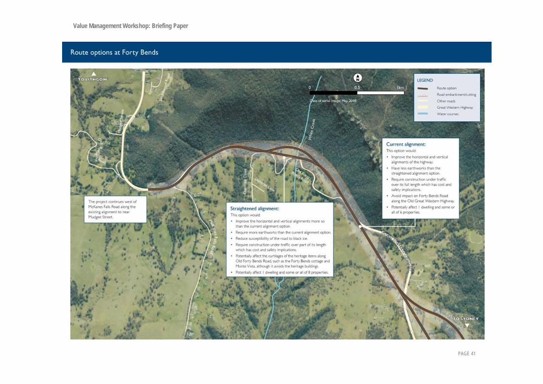
The alignment would have two sub-options located about 400 metres east of the turn-off to Old Forty Bends Road (refer to map at end of section). These sub-options are: the Forty Bends current alignment and the Forty Bends straight alignment.
Forty Bends current alignment The alignment of this sub-option would follow the route of the existing highway, but would incorporate improvements to enable this section of road to meet the 90 kilometres per hour design speed criteria. By keeping to the existing alignment, opportunities would be lost to move the road away from the shadow of Hassans Walls and thereby reduce the formation of black ice on the road.
Forty Bends straight alignment This sub-option would deviate to the south-west of the existing highway, bypassing three substandard curves on the existing highway and would move the alignment further from the base of Hassans Walls. As well as enabling some safety improvements, this alignment would likely help to reduce the formation of black ice. Although this sub-option would take the alignment closer to the heritage items located just south of the Old Forty Bends Road, none of these items would be directly affected.
6.2. Summary of technical, environmental and social considerations
Issue Current alignment Straight alignment Technical Would have a maximum grade of 6%. Would have a maximum grade of 8%. Horizontal and vertical alignments of
the highway would be improved. A far greater improvement to the
horizontal and vertical alignments of the highway than the current alignment would be provided.
The extent of earthworks would be reduced.
A greater extent of earthworks than the current alignment would be required.
Would not reduce susceptibility of the road to black ice.
Would reduce susceptibility of the road to black ice.
Would require construction under traffic over its full length.
Would require construction under traffic over part of its length.
Environmental Would affect 15 ha of high conservation value vegetation, but vegetation clearance is limited as this alignment predominantly follows the existing highway.
Would affect 15 ha of high conservation value vegetation, but vegetation clearance only required where there are deviations from the existing highway.
Would require a new crossing of Whites Creek, which could affect the hydrological regime.
Would require a new crossing of Whites Creek, which could affect the hydrological regime.

Value Management Workshop: Briefing Paper
D:\Documents and Settings\aspinks\My Documents\Work\EN02481\VMW\Briefing paper\VMW Briefing Paper ~ comprehensive.doc PAGE 40
Issue Current alignment Straight alignment Social 0 dwellings would be affected. 0 dwellings would be affected. Would affect 25 ha of Class 3
agricultural land. Would affect 25 ha of Class 3
agricultural land. Would avoid impacts on Aboriginal site
in this area. Would avoid impacts on Aboriginal site
in this area. Impacts on Heritage items along the
Old Forty Bends Road would be avoided.
Would affect the curtilages of the heritage items along the Old Great Western Highway, such as Forty Bends cottage and Monte Vista, although it would avoids the heritage item itself.
Would largely avoid affecting the historic route of Mitchells Road.
The historic route of Mitchells Road would be crossed.
6.3. Additional geotechnical information
Current Alignment Straight Alignment Risk from rock fall from Hassan's Walls is very
low Risk from rock fall from Hassan's Walls is very
low Cuttings in talus would need to be retained and
should be avoided Cuttings in talus would need to be retained and
should be avoided
6.4. Constructability considerations
Current Alignment Straight Alignment Existing alignment would be more
difficult/complicated to manage the mix of construction and local traffic.
Greenfield site would make construction easier to manage.
Construction closer to the unstable talus slope should be avoided.
Avoids talus slopes.
Provided talus slope could be avoided there is no great differentiation between constructability of the route options.
Provided talus slope could be avoided there is no great differentiation between constructability of the route options.
Value Management Workshop: Briefing Paper
PAGE 41

Value Management Workshop: Briefing Paper
D:\Documents and Settings\aspinks\My Documents\Work\EN02481\VMW\Briefing paper\VMW Briefing Paper ~ comprehensive.doc PAGE 42

Value Management Workshop: Briefing Paper
D:\Documents and Settings\aspinks\My Documents\Work\EN02481\VMW\Briefing paper\VMW Briefing Paper ~ comprehensive.doc PAGE 43

Value Management Workshop: Briefing Paper
D:\Documents and Settings\aspinks\My Documents\Work\EN02481\VMW\Briefing paper\VMW Briefing Paper ~ comprehensive.doc PAGE 44

Value Management Workshop: Briefing Paper
7. Additional information 7.1. Submissions update
7.2. Costs
7.3. Strategic road design

7.1 Submissions summary update The project team received 266 feedback forms and personal letters. Over 3000 form letters and emails were received expressing opposition to the project.
Most of the submissions expressing opposition to the project raised concerns about trucks and resident safety, cost, the bottleneck at Blackheath and the heritage, tourism and social impacts of the upgrade. Several suggested safety upgrades and speed control measures as an alternative to the highway upgrade. Many suggested rail alternatives for freight and upgrading the Bell’s Line of Road. Many comments were received concerning viaducts, mostly opposing them on the grounds of visual and noise impacts.
Most important factors:
Respondents who completed the feedback form were asked to list three factors they considered most important when selecting the preferred route. The highest response was safety, closely followed by travel time and efficiency and visual and noise impacts for residents.

Which specific aspect of these issues do you feel is most relevant?
The graph below indicates the issue listed in response to this question. If two answers were given they were each ranked 0.5, if three answers were given they were each ranked 0.333. Please note the scale of this graph is different to the scale of the previous graph.
0 20 40 60 80 100
1
Other
Biodiversity
Heritage
Value for money - managementof public fundsPrivate property impacts
Local traffic flow
Amenity and local character
Visual and noise impacts forlocal residentsLocal business and tourism
Travel time and efficiency
Road Safety

Mount Victoria Of the 141 responses that answered the area specific question, 63 preferred the long tunnel option, 14 preferred the outer bypass and 3 preferred the inner bypass. A further 9 responses expressed preference for either tunnel option. Many responses expressed opposition to the route options at Mount Victoria, however gave limited support to the long tunnel option. 17 responses expressed opposition to the inner bypass.
The reasons for opposing all options were:
• Cost. • Engineering. • Safety of tunnels. • Environmental impact. • Noise and property impacts.
The reasons most often given for the long tunnel preference were:
• Lessening visual impact (sometimes with reference to avoiding viaducts). • Minimising effect on property. • Minimising impact on Mount Victoria village. • Easy grades. • Fuel efficiency of easy grades. • Heritage:
• Preserving Berghoffer’s Pass. • Preserving views to convict built walls. • Minimising impact on The Grange.
The reasons given for the outer bypass preference were: • Shorter tunnel, which will have less ventilation issues. • Shorter viaduct, which will have less visual impact. • Less impact on properties than the inner bypass. • Less conflict with local traffic, especially at Mount York Road.
The reasons given for the inner bypass preference were:
• Economical. • Access to Mount Victoria township.
Opposition to the inner bypass focussed on: • Opposition to the long viaduct. • Impact on The Grange curtilage. • Potential for sun-blindness. • Community severance.
One response indicated opposition to the 8% grade of both the inner and outer bypasses.

Alternative construction ideas were suggested:
• A short or long tunnel exiting through the protruding cliff at Berghoffer’s Pass with a short viaduct hugging the Berghoffer’s Pass line and rejoining Victoria Pass at the point where it meets Major Mitchell’s original line for the lower Pass.
• Three arched passages under the new tunnel to access the other side of Berghoffer’s Pass. • Pass lower under the railway and enter the long tunnel at a deeper level to avoid a long viaduct. Enables
lowering of the tunnel exit and enables the road to wind closer to the valley floor. • Use the National Park corner of land at Browntown to avoid houses. •
Little Hartley Of the 88 responses received for the area specific question, opinion was divided about whether the current alignment or the bypass was preferred. 23 responses specified a preference for the bypass and 19 specified a preference for the current alignment.
The reasons given for preferring the current alignment were:
• Most economic solution. • Less impact and disruption. • Straighter road. • Less environmental impact. • Less property acquisition. • Less noise impacts for residents south of the highway.
The reasons given for preferring the bypass alignment were:
• Heritage. • Safety of intersections (particularly Cox’s River Road). • Less vibration impact on heritage buildings. • Four lanes. • To avoid impact on the Harp of Erin.
Concerns expressed for either option:
• Several comments opposing viaducts were received. • Heritage. • Visual impact. • Amenity and local character. • Concern was expressed that increased speed would mean increased accidents as people entered/exited
the highway. • The danger of intersections was mentioned a number of times, mainly Cox’s River Road but also Baaner’s
Lane and Brown’s Gap Road where they meet the Great Western Highway.

Alternative construction ideas were suggested:
• Harp of Erin/ Ambermere bypass with modification of removal of the curve from the bottom of the descent from Mount Victoria to Coxs River Road, cutting through the hill before Coxs River Road, (not as shown, curve around it).
• A different four lane route close to the northern side of the highway to minimize the damage to vegetation, minimize the acquisition of dwellings, avoid severing the new subdivisions on the western side of the highway, minimize the severance of existing housing clusters and prevent exposing the residents to the south of the highway to greater noise impacts.
River Lett Hill Of the 81 responses received for the area specific question, 16 were in favour of the southern alignment, 24 were in favour of the northern alignment and 5 supported current works only.
The reasons given for the southern alignment were:
• Minimising visual impact. • Minimising gradient. • Less expensive option. • Safety. • Straighter. • Minimises impact on watercourses, riparian vegetation and threatened species adjacent to Blackmans
Creek. • Less earthworks required.
Concerns raised about the southern alignment were for the 10ha of high conservation land, protecting the extended curtilage of Fernhill and the impact on property owners.
The reasons given for the northern alignment were:
• Less disruption during construction. • Less impact on property. • Less impact on biodiversity. • Less intersections. • Land conservation.
Alternative construction ideas were suggested:
• A line closer to the current route to lessen the impact of the scar such a choice will make. • The northern alignment going under the existing highway in a cut to improve the grade and leave the old
highway with only two intersections to the new. • The southern alignment switching to the current highway where the highway crosses the southern alignment
and then rejoining the road design where the options merge to the west.
Forty Bends Of the 76 responses received for the area specific question, 37 responses indicated a preference for the straightened alignment and 11 responses indicated a preference for the current alignment. Several responses indicated that they

preferred neither option. One response raised concerns that the options didn’t address ice or rock slide issues. Another response questioned whether the large fill required for the straightened alignment would address weather issues. Concern was raised in another response that Old Forty Bends Road be preserved.
The reasons given for preferring the straightened alignment were:
• Safety. • Avoiding black ice. • To minimise traffic disruption.
The reasons given for preferring the current alignment were:
• Less impact on properties. • Less impact on heritage items. • Less damaging to surrounding areas. • Less impact on native vegetation. • Less expensive.
Alternative construction ideas were suggested:
• A straight line from south east of the Old Forty Bends Road, where the Great Western Highway intersects with the road design to just north east of the McKanes Falls Road, Great Western Highway intersection.
• Minimum deviation from the current highway.

GREAT WESTERN HIGHWAY – MOUNT VICTORIA TO LITHGOW UPGRADE
PRELIMINARY COST ESTIMATES FOR DISCUSSION AT NOVEMBER 2009
VALUE MANAGEMENT WORKSHOP
26 November 2009
Note: refer to attached diagram for route options Estimated Cost (2009 dollars incl contingency) MOUNT VICTORIA OPTIONS Current cost estimates are not sufficiently robust for use.
1.1 Outer Bypass (Short Tunnel) 1.2 Outer Bypass (Long Tunnel) 1.3 Inner Bypass
LITTLE HARTLEY OPTIONS (3 lanes)
2.1 Existing alignment $30M 2.2 Ambermere / Harp of Erin Bypass $35M
HARTLEY (3 lanes)
3.0 Hartley common $80M RIVER LETT OPTIONS (4 lanes)
4.1 Northern alignment $85M 4.2 Southern alignment $70M
FORTY BENDS EAST (3 lanes)
5.0 Common alignment $25M FORTY BENDS OPTIONS (3 lanes)
6.1 Current alignment $25M 6.2 Straight alignment $30M
FORTY BENDS WEST (3 lanes)
7.0 Common alignment $20M
