updated market analysis - pipeline safety trust · updated market analysis subject property the...
TRANSCRIPT

U P D A T E D M A R K E T A N A L Y S I S S U B J E C T P R O P E R T Y
THE IMPACT OF NATURAL GAS PIPELINES ON PROPERTY VALUES
P R E P A R E D F O R Mr. Henry P. Morse Jr. General Manager/Project Manager Palomar Gas Transmission LLC 1400 SW Fifth Avenue, Suite 900 Portland, Oregon 97201
P R E P A R E D B Y Donald R. Palmer, MAI

February 21, 2008 Mr. Henry P. Morse Jr. General Manager/Project Manager Palomar Gas Transmission LLC 1400 SW Fifth Avenue, Suite 900 Portland, Oregon 97201 RE: THE IMPACT OF NATURAL GAS PIPELINES
ON PROPERTY VALUES At the request of the client, This report represents a real property consulting appraisal assignment and is intended to comply with the reporting requirements of Standard (5) of the Uniform Standards of Professional Appraisal Practice (USPAP) Real Property Appraisal Consulting, Reporting, as adopted by the Appraisal Institute, and the Oregon Appraiser Certification and Licensure Board. The appraisal service was performed in such a manner that the results of the analysis, opinion, or conclusion be that of a disinterested third party.
We have prepared a market study regarding the impact of natural gas pipelines on property values. PGP Valuation Inc. has completed a number of market studies and was hired to do a market study for NW Natural Gas’s proposed pipeline as well as a subsequent update. This market study will focus on the newest data available and will use data from sales ranging from 2004-present. The subject sales to be analyzed are all encumbered by right of way easements because of their location with respect to the NW Natural Gas pipeline that was installed in 2003/2004. All comparable sales are in the same or similar rural market areas and were sold within the same timeframe as the subject properties. The pipeline route analyzed starts in Molalla, Oregon (Clackamas County,) travelling west into Washington County, then north along the western edge of the Portland Metropolitan area ending in Mist, Oregon in Columbia County. The presentation of our findings is included within this report, as well as a description of the methodology and data collected. In determining the effect of high-pressure natural gas pipelines, we have presented analysis of sales in Clackamas and Washington Counties. We have performed a comprehensive study of recent sales along pipeline corridors and compared those sales with non-affected, comparable property sales. This comparison attempts to isolate any influence on property values caused by natural gas pipelines.
110 SW Yamhill Street, Suite 200Portland, OR 97204 503.226.0983503.273.4273 facsimile
www.pgpinc.com
Real Estate Appraisers and ConsultantsOffiCEs in CAlifORniA, OREgOn & WAshingtOn
VA L UA T I O N I N CPGP
VA L UA T I O N I N CPGP

LETTER OF TRANSMITTAL (CONTINUED)
COPYRIGHT © 2008 PGP VALUATION INC. ALL RIGHTS RESERVED
Our conclusion is that there is no measurable impact on property values resulting from high-pressure natural gas pipelines. Significant professional assistance in the research and preparation of this report has been provided by Real Estate Analyst Rob K. Klever and Brandon M. Krahn (OR State Registered Appraiser Assistant No. AA02323). Sincerely, PGP VALUATION INC
Donald R. Palmer, MAI OR State Certified General Appraiser No. C000060

C080104 COPYRIGHT © 2008 PGP VALUATION INC. ALL RIGHTS RESERVED 1
IMPACT OF NATURAL GAS PIPELINE ON PROPERTY VALUES
INTRODUCTION This analysis represents an extension of the previous studies regarding the impact of high-pressure natural gas pipelines on property values. The first phase was completed in 2000 and the second was completed in 2004 and then submitted to NW Natural Gas. This extension will include recent sales (2004-present) that are located along the South Mist Pipeline Extension Project. Properties are being evaluated to measure impact of pipeline easements on property values. This information will then be used to assist Palomar Gas Transmission LLC in forecasting possible compensation for property owners along their proposed pipeline. The study utilizes a sales comparison methodology as was used in the NW Natural market studies. This also includes looking at a body of literature relating to the impact of utility easements and their effect on real estate. Also, a number of professional and scholarly studies were read as part of our market area research and general understanding of easements. This report will attempt to isolate the effect of natural gas pipelines from the wide range of variables that effect property value and sale price. We have researched sales of properties along the South Mist Pipeline, the existing project routed from Molalla, Oregon to Mist, Oregon, that are affected by the natural gas pipeline ranging in size, type and use. The affected properties that have recently sold are compared with non-affected properties. Additionally, the principals involved in the subject sales (buyers, sellers, and real estate agents) were interviewed when possible to help identify their motivations regarding the pipeline location when making these transactions. Although it may not be feasible to measure the precise impact of a variable isolated from several transactions, we believe that by studying all affected transactions, a reasonable data pool can be analyzed from which to draw an accurate conclusion. This study is important because it can help to predict long term effects on property value for properties within the pipeline’s easement area. This can help Palomar Gas Transmission LLC in estimating possible costs and risks associated with their project. OBJECTIVE/OVERVIEW The objective of this study is to determine the effect of natural gas pipelines on property values. This will be accomplished by locating sales of properties influenced by a natural gas pipeline and comparing that sale (subject sale) with sales of non-influenced comparable properties. The study will be presented by first outlining the approach taken in the study. This will be followed by a description of the data collection, which includes two separate study areas. Conclusions will be drawn from the data as well as a discussion of the results of similar studies. METHODOLOGY In order to isolate the effect of natural gas pipelines on property values, we began our study by identifying properties encumbered by the South Mist Pipeline and of those, the properties that have sold since January 2004. These properties were then researched for transactions through county records, Metroscan data, and the Realtors Multiple Listing Service (RMLS.) Transactions that were not arm’s length (title transfers, related parties etc.) were excluded. In addition, there were a limited number of encumbered sales that were excluded because a meaningful conclusion could not be drawn from the data. This included unique properties that are difficult to bracket with comparable properties, or transactions that were influenced by unusual buyer/seller motivation, such as property assemblage, business opportunity, foreclosures, etc.

IMPACT OF NATURAL GAS PIPELINE ON PROPERTY VALUES (CONTINUED)
C080104 COPYRIGHT © 2008 PGP VALUATION INC. ALL RIGHTS RESERVED 2
Each sale encumbered by a natural gas pipeline (subject sale) was then further researched by inspecting the property and attempting to confirm the transaction with a participant. During the confirmation process, we asked whether or not the pipeline affected the transaction. A 61 percent confirmation rate (11 of 18 reportable sales) was achieved, as several parties were either unavailable or not willing to respond. To determine whether or not the natural gas pipeline affected value, similar sales (comparable sales) were researched using county records and RMLS. This process attempts to bracket the subject sale with the most similar property types, sold under similar conditions, to isolate the effects of the natural gas pipeline. Factors such as location, size, zoning, date of sale, improvement type, and quality were considered. Reliance has been placed upon finding comparables similar to the subject in this regard. Any adjustments made were limited to show an accurate picture of the market and maintain a level of objectivity. Those comparable sales that occurred generally one year or greater before or after the subject sale are adjusted appropriately at approximately 3 percent per year. This process represents a paired sales analysis, however, rather than one; we are expanding the number of comparables to two or more. The comparables were then averaged on an overall price (property as a whole) or a unit price such as price per acre or price per square foot and compared with the subject sale. The difference was then converted to a positive or negative percentage of the subject sale. For example, a subject sale greater than the comparable average would represent a positive percentage. A subject sale at a level below the comparable average is a negative percentage.
Subject Sale Price – Average Comparable Sale Price Subject Sale Price = ± %
By averaging comparables, the variability of the data is reduced. We have used both an overall sale price method and a price per unit analysis where difference in size required adjustments. We have selected a series of comparables, to average a range of highly similar properties, thereby reducing the variability caused by selecting only one comparable. There are many variables involved in a real estate transaction, particularly in residential properties, involve personal preference and are very difficult to quantify. We have attempted to avoid statistical analysis of the data, choosing to analyze each sale as we would in a typical appraisal process. It should be noted that this report represents a market analysis, not an appraisal. Therefore a complete appraisal process was not performed for each set of data. The resulting percentage (data point) represents a positive or negative difference between the subject sales price and the average price of the comparables. Whether a single data point is positive or negative does not indicate the precise impact of the natural gas pipeline. However, by applying the same methodology over each subject sale, the actual impact will be distinguishable when the whole group of data is considered. If there is a negative effect, we would expect to see a negative trend in the data. Also, our survey of transaction participants would indicate that the natural gas pipeline influenced their purchase if there were an impact on value. DATA COLLECTION The study area for the purposes of this report are properties along the South Mist pipeline expansion project. We have analyzed sales of affected properties from January 2004 to January 2008 in Clackamas and Washington counties, roughly separated by Highway 99W. Although the pipeline affected properties in Marion County we were unable to identify arm’s length transactions within the analysis period. Marion County did however provide some sales that could be used as comparable sales because of their similarities to subject properties.

IMPACT OF NATURAL GAS PIPELINE ON PROPERTY VALUES (CONTINUED)
C080104 COPYRIGHT © 2008 PGP VALUATION INC. ALL RIGHTS RESERVED 3
Construction of this South Mist pipeline was completed in late 2004, so nearly every sale utilized reflects properties encumbered with permanent easements for the finished pipeline. One sale in Washington County did have an existing overhead power line easement that could have some impact on the sales price but only a corner of the property (in filbert orchard production away from the main residence) was impacted. One sale in Washington County occurred on a property that had two pipeline easements, one from a late 1980’s installation in addition to the recent 2003 construction.
Several encumbered properties that sold in this time frame included those that were not an arm’s length transaction (between family members) or were for special purpose properties that had owner/user characteristics.
The 6.8-acre site at 18790 SW Scholls-Sherwood Road ($995,000 on August 13, 2007) was the purchase of the Windmill Nursery in Sherwood that was described as “turnkey” for commercial operation and included multiple commercial greenhouses and processing structures as well as a single-family residence.
The 7.05-acre site of the newly constructed Timberline Baptist Church was also not utilized. The purchase in December 2004 for $500,000 represents a site on the edge of the Urban Growth Boundary for Sherwood but was not expected to be available for urban expansion for many years. The property has an elongated triangular shape the limits development potential but has significant street frontage along Highway 99W. The existing manufactured home was moved for new construction of the church, which was a conditional use in the zoning district. The Timberline representative said they were looking for a site with proximity to an urban area and this property matched their needs. Overall, this site and the price paid on a per acre basis represented the motivation for a particular buyer and do not reflect market value for similar properties.
In Clackamas County, the December 2004 sale for $1,600,000 of a 257.43-acre nursery improved with two single-family residences was also excluded from this analysis. This was an estate sale with a highly motivated seller that accepted a below market price for a quick sale.
These transactions are summarized on the Excluded Sales Tabulation Chart at the end of the Addenda.
Clackamas County (Eastern Portion of Pipeline)--- This area represents properties just outside of the Portland Metropolitan area east of Highway 99W. Most of the area in this region is outside the Urban Growth Boundary (UGB). This area is comprised primarily of properties that are generally zoned for rural residential or farm/forest use (RRFF-5, AF-5 or EFU.) Each of these zoning types promotes rural homesite use and farming uses. There are also occasional industrial and commercial uses within this market area. We attempted to interview both buyers and sellers in order to obtain accurate information from both parties to the transaction. A confirmation rate of 62.5 percent (5/8) was achieved for this section. Of the parties interviewed regarding subject sales, there were no indications that the pipeline had negatively impacted property value or sales price. Overall, 8 encumbered sales were utilized from this section. This included residential, agricultural and industrial sales. The data points range from -2.93% to +9.23 percent with an average of +3.14 percent. This indicates little to no affect on value for the encumbered properties.

Site Sales Year Unit # Ref. Parcel # Property Type Size(AC) Price Built Price Unit Sale Date Comp Avg. Difference
1 41E06 01701 Vacant Industrial Land 2.00 $375,000 N/A $4.30 SF 11/13/2006 $4.15 3.65%2 41E07 05600 Rural Residential 3.95 $375,000 1909 $375,000 Site 3/31/2006 $386,000 -2.93%3 41E20 00606 Rural Residential 2.93 $399,900 1974 $253.90 Improved SF 10/17/2005 $240.76 5.18%4 41E20 00616 Rural Residential Land 5.75 $220,000 N/A $38,261 AC 3/2/2005 $38,684 -1.10%5 31W08B 01100 Rural Residential 5.33 $549,000 1957 $549,000 Site 3/11/2004 $511,300 6.87%6 41E06 01301 Rural Residential 9.43 $385,000 1925 $385,000 Site 5/31/2006 $364,302 5.38%7 41E26 01700 Rural Residential 14.02 $425,000 1930 $425,000 Site 3/5/2007 $420,000 -1.18%8 31W16 02306 Rural Residential 20.00 $905,000 1980 $905,000 Site 12/15/2004 $821,500 9.23%
Total Average Variation 3.14%
Clackamas Co. Sales

IMPACT OF NATURAL GAS PIPELINE ON PROPERTY VALUES (CONTINUED)
C080104 COPYRIGHT © 2008 PGP VALUATION INC. ALL RIGHTS RESERVED 5
Washington County Study Area--This study area represents the eastern portion of the Portland metropolitan area. The area is primarily rural residential with homesites generally from 5 to 10 acres in size. Larger farmlands from 20 to 100 acres with and without existing or allowed homesites are interspersed. These larger farmlands vary in value considerations with differing soil conditions, irrigation rights, floodplain, and tillable areas, among others.
Overall, 10 encumbered sales were utilized from this section. This included rural residential sales on small and large parcels as well as large acreage farms. The data points range from -5.60 percent to +13.50 percent with an average of +2.23 percent. This indicates no affect on value for encumbered properties.
Located within this area are two natural gas transmission lines constructed by Northwest Natural. One, constructed in the Dairy Creek area north of Highway 26 in the late 1980’s and the new 24-inch line installed in 2003-2004 that is routed from the Upper Dairy Creek area, south across Washington County skirting the west side of North Plains, Hillsboro, and Sherwood. The corridor turns to the east, just south of Sherwood and continues into Clackamas County.
The data utilized in this study area was restricted to those properties encumbered by the natural gas pipeline built in 2003/2004 and were involved in a market value transaction since January 2004. Those 10 sales meeting these criteria are described in the Addenda of this report.
A confirmation rate of 60 percent (6 of 10) of the sales analyzed was achieved for this section. While several property owners indicated they felt some amount of negative value impact due to the location of the pipeline, no one could quantify any discount attributed to the sales price and the sales comparables did not reflect actual price reductions.

Site Sales Year Unit # Ref. Parcel # Property Type Size (AC) Price Built Price Unit Sale Date Comp Avg. Difference
1 1S31200 1300 Rural Residential 8.90 $550,000 2001 $550,000 Site 4/8/2005 $537,282 2.31%2 2S20300 900, 1000 Rural Residential 29.10 $750,000 1936 $750,000 Site 3/11/2004 $697,167 7.04%3 2N31600 1200 Rural Residential 8.23 $715,000 1920 Remod $715,000 Site 8/15/2007 $721,017 -0.84%4 1N30200 1100 Improved Farmland 64.26 $865,000 1936 $13,461 AC 8/27/2007 $11,643 13.50%5 2S20400 100 Improved Farmland 79.67 $715,000 1962 $8,975 AC 7/15/2004 $8,831 1.60%6 1N335 00 1500 (+3 other) Land-Farm/Forest 93.40 $700,000 n/a $7,495 AC 4/17/2007 $7,914 -5.60%7 2S22400 400, 501, 513 Improved Farmland 75.24 $775,000 1971 $10,300 AC 11/12/2004 $9,582 6.98%8 2N31600 502, 503, 504 Rural Residential 11.66 $400,000 1926 $400,000 Site 3/15/2007 $418,197 -4.55%9 2N31600 502, 503, 504 Rural Residential 11.66 $283,100 1926 $283,100 Site 7/16/2006 $270,975 4.28%10 1S23000 302 Rural Residential 10.28 $950,000 1995 $950,000 Site 4/21/2006 $983,000 -3.47%
Total Average Variation 2.13%
Washington Co. Sales

IMPACT OF NATURAL GAS PIPELINE ON PROPERTY VALUES (CONTINUED)
C080104 COPYRIGHT © 2008 PGP VALUATION INC. ALL RIGHTS RESERVED 7
FINDINGS Based upon our analysis and investigation, there is no measurable impact on property values caused by natural gas pipelines. There results are summarized as follows:
Clackamas County Washington County Total of All Sections Affected Sales 8 10 19 Price Range Difference -2.93% to +9.23% -5.60% to +13.50% -5.60% to +13.50% Avg Difference +2.13% +3.14% +2.58%
No significant trends were indicated by the data collected. We would expect to see a negative difference trend greater than 10 percent to be able to conclude a decrease in market value was evident, but not such trend was observable. Additionally, confirmation comments indicated that a majority of the property owners felt the pipeline had little to no impact on their decisions to purchase the properties and did not perceive a long term impact on value of their property. Although the data pool may be somewhat limited due to the limited number of encumbered properties in the area, the methodology applied to the study allows for accurate conclusions to be drawn. By testing for impacted property values, we are essentially looking for any negative effect, whether real or perceived, as a result of the perceived hazards of having a natural gas line present. The data selected is the group of sales where the effect of the natural gas pipeline can be isolated from other factors. Sales were excluded if significantly impacted by electrical transmission easements or if the parcel was not directly encumbered. It can be assumed that if values were impacted by any negative stigma, this effect would most likely occur where easements are recorded on deed documents and the line is well marked and known. Second, a negative impact on value would likely be found in residential properties, which is the most common property type within the study. Large diameter natural gas distribution pipelines are typically located within roadways or other easements when passing through urban areas. Due to this characteristic, much of the data collected represents either rural areas, or recently suburbanized areas that have expanded into areas encumbered by natural gas pipeline easements. This point is of particular importance for determining if there is an impact on property values. It has been our experience that purchasers of commercial and industrial property are mainly concerned with how the easement will affect access, vacant land use, and configuration of improvements. However, any stigma regarding pipeline incidents do not appear to be a consideration of a typical buyer in these markets. It can be assumed that residential properties are the most likely of all property types to be impacted by a stigma effect. Since our study has produced mainly data concerning residential properties, this data pool would be the most likely to indicate any impact on value. PIPELINE EVENTS IN THE REGION In the previous market studies done for NW Natural there were four pipeline incidents in the Pacific Northwest that occurred between 1997 and 2000 and two incidents that happened between 2000 and 2004, which took place in New Mexico and Washington. There have been few publicized transmission line incidents since 2004. The two incidents found during research were ruptures in New Jersey and Pennsylvania of small service lines to individual properties and did not involve the larger transmission lines that are the focus of this survey.

IMPACT OF NATURAL GAS PIPELINE ON PROPERTY VALUES (CONTINUED)
C080104 COPYRIGHT © 2008 PGP VALUATION INC. ALL RIGHTS RESERVED 8
RELATED STUDIES In addition to studying the impact of natural gas pipelines in the Portland area, we also researched related studies regarding utility easements. There are numerous articles addressing the impact of high-voltage transmission lines on residential property values, but limited literature regarding natural gas pipelines. The first study was a speculative study entitled Forecast of the Net Economic Benefits of a Proposed LNG Terminal in Coos County, Oregon. This article was released on October 16, 2006 and published by ECO Northwest. This article is related in that it forecasts effects of a proposed Liquid Natural Gas pipeline (LNG). Effectively LNG is the liquefied state of Natural Gas. It makes transportation of natural gas easier and more cost effective. Once it reaches its destination it is “regassified” for distribution and use. This study discusses the proposed benefits to the local economy of having an LNG storage facility. It discusses the feasibility, drawbacks and bonuses associated with the proposed project. Among the identified possible drawbacks, the study explores the idea that there might be a decrease in value as a result of being adjacent to a LNG storage tank. In order to study this possibility, data was taken from county tax assessors to study properties near long-standing LNG facilities. The facilities studied are located in Portland and Newport. This report focused more on industrial/commercial type properties within a half-mile radius. The study then compared the values of the properties that may be affected by the presence of the LNG facility to those in the same market area and compared the values. The net conclusion of the studies section on property values was that there was “no evidence of disamenity”1. The second and more relevant study was performed by William N. Kinnard, Jr., Sue Ann Dickey and Beth Geckler, which was summarized in their article, entitled Natural Gas Pipeline Impact on Residential Property Values: An Empirical Study of Two Market Areas. 2 This June/July 1994 analysis was performed using a multiple regression analysis in two separate market areas. Sales data was collected from two public sources for residential properties within one mile of a natural gas pipeline. Two conclusions were made: (1) no systematic pattern of measurable negative impacts on sales prices of residential properties close to an existing or proposed high-pressure gas transmission pipeline was observed; and (2) no systematic pattern of variations in sales price effects was observed and no correlation was observed between price levels and distance from the pipeline. The results of the multiple regression analysis are dependant upon acquiring a large pool of data. In order to form such a data set, public records must be relied upon with little or no confirmation process. In markets where sales are plentiful and the properties demonstrate a low degree of variability, such as a residential subdivisions, this method can be used to accurately isolate the effects of specific variables. However, the approach has significant drawbacks in areas of limited sales and where properties demonstrate a high degree of variability, particularly rural areas. New Literature--- A scholarly study done by Professors of Economics, and a Professor of Finance at Western Washington University entitled Environmental Hazards and Residential Property Values: Evidence from a Major Pipeline Event was studied and consulted3. This article was written in 2004 and uses a hedonic housing price methodology. This type of modeling addresses the bundle of amenities present in a home purchase and seeks to quantify them. 1 ECONorthwest, “Forecast of the Net Economic Benefits of a Proposed LNG Terminal in Coos County, Oregon October, 16 2006, 1-8 2 William N. Kinnard, Jr., Sue Ann Dickey and Mary Beth Geckler, “Natural Gas Pipeline Impact on Residential Property Values: An Empirical Study of Two Market Area,” Right of Way, June/July 1994, 26-29 3 Benson, Hagen, Hansen, “Environmental Hazards and Residential Property Values: Evidence from a Major Pipeline Event”

IMPACT OF NATURAL GAS PIPELINE ON PROPERTY VALUES (CONTINUED)
C080104 COPYRIGHT © 2008 PGP VALUATION INC. ALL RIGHTS RESERVED 9
It focuses mainly on the pipeline incident in Bellingham, Washington that involved gasoline and not natural gas. This incident, which occurred in 1999, is the rupture of the Olympic pipeline and the subsequent 229,000 gallon gasoline leak into Whatcom Creek and subsequent fire. The age and material condition of the facility was a factor in the incident. The study then focuses on the hypothesis that, if there is not a highly publicized event, properties on a pipeline corridor do not have a deviation in average price as a result of their orientation to the pipeline. Data from properties within the pipeline corridor is then compared with data from the same market area without any pipeline orientation. Pre and post-pipeline accident data analysis are also compared to obtain any variance in price that could be attributed to easement value. Conclusions for the study reveal that proximity to a pipeline corridor does not impact value of a property. However proximity to a pipeline incident site does affect value, albeit in the short term, normally. Long term value effects are not readily observable. The second conclusion comes as no surprise, as accident sites are an obvious disamenity. The first part of the study uses a different methodology and scope; however the conclusion supports this report. A national case study was conducted in 2001 by the Interstate Natural Gas Association of America (INGAA).4 This study looked at four communities from various regions around the country to determine the impact of having a property located on a natural gas pipeline. The study found no significant impact on sales price. These areas included a suburban area traversed by one natural gas pipeline, a suburban area traversed by multiple natural gas and products pipelines, a rural area traversed by one natural gas pipeline, and a commercial area traversed by a natural gas and one different product line. This study is similar to our study in scope. Data was collected on sales and development activity surrounding natural gas pipelines. In order to measure the impact of a pipeline on property values, sale transactions on and off the pipeline were compared. Property types included vacant sales, single family dwellings, and combined with statistical analysis in comparison of averages. In addition to the sales analysis, a discussion of case law and literature relating to natural gas pipelines is analyzed. The overall conclusions are as follows. There is no discernable and significant impact on sales price of property located along
natural gas pipelines in the areas studied. The size (diameter) of the pipeline does not effect on sales price in the study areas.
The product carried by the pipeline has no impact on the sales price.
There is no discernable impact on demand for properties located along natural gas pipelines
(no extended marketing period). The existence of a pipeline does not impede development of the surrounding properties in
the study area. The existence of a pipeline has no significant impact on development decisions such as lot
size or type of improvement constructed in the areas studied. It is likely that the results and conclusions developed in the study are transferable to other
market situations across the country involving natural gas pipelines.
4 Allen, Williford and Seal, Inc., “Natural Gas Impact Study.” INGAA, 2001

IMPACT OF NATURAL GAS PIPELINE ON PROPERTY VALUES (CONTINUED)
C080104 COPYRIGHT © 2008 PGP VALUATION INC. ALL RIGHTS RESERVED 10
Overall, this study is considered most similar in scope and structure to our analysis. The similar results found by Allen, Willifor & Seale, Inc, provides further support for the conclusions made herein, that natural gas pipelines do not have a negative impact on property values. CONCLUSIONS Our conclusions indicate that there is no measurable long-term impact on property values resulting from natural gas pipelines for the particular pipeline project studied. As reported in previous studies done for NW Natural, the variations in short term values are either not substantial or non-existent. Interviews with buyers and brokers indicated no measurable impact on value. However, it is not inconceivable that there could be a material affect on value to an individual potential buyer because of the pipeline. This could come as a result of limits on crop types (shallow root crops only) or prohibitions on permanent structures within the easement area. Data was considered on marketing periods for encumbered properties. There was no trend in the data to suggest an extension of marketing periods for properties with gas pipeline easements. The results of the study are conclusive in asserting that no measurable long-term impact on encumbered properties exists. This conclusion is also supported by additional research on related studies. Although the results of this particular study may be more statistically significant with a larger data pool, the degree of accuracy achieved by using strict parameters (dates of sale, distance from easement, etc) were not compromised. It is our opinion that by broadening the parameters the results may be skewed, but there would be an increased range of percentages, or standard deviation from the mean. Our conclusions can be summarized as follows: The long-term impact of natural gas pipeline easements on property values within the study
area is insignificant. Residential properties are not impacted by a natural gas pipelines easement any more or
less than other property types. Related studies regarding utility easements indicate that their impact on property values is
insignificant.

C080104 COPYRIGHT © 2008 PGP VALUATION INC. ALL RIGHTS RESERVED 11
CERTIFICATE OF APPRAISAL
We certify that, to the best of our knowledge and belief:
The statements of fact contained in this report are true and correct.
The reported analyses, opinions, and conclusions are limited only by the reported assumptions and limiting conditions, and are our personal, impartial, and unbiased professional analyses, opinions, and conclusions.
I have no present or prospective interest in the properties analyzed in this report, and no personal interest with respect to the parties involved.
I have no bias with respect to the properties analyzed, or to the parties involved with this assignment.
My engagement in this assignment was not contingent upon developing or reporting predetermined results.
My compensation for completing this assignment is not contingent upon the development or reporting of a predetermined result or direction in the result that favors the cause of the client, the attainment of a stipulated result, or the occurrence of a subsequent event directly related to the intended use of this report.
My analyses, opinions, and conclusions were developed, and this report has been prepared, in conformity with the requirements of the Code of Professional Ethics and Standards of Professional Appraisal Practice of the Appraisal Institute, and the Uniform Standards of Professional Appraisal Practice, as set forth by the Appraisal Standards Board of the Appraisal Foundation.
Real Estate Analyst Rob K. Klever and Brandon Krahn (OR State Registered Appraiser Assistant No. AA02323) made a personal inspection of the property that is the subject of this report and all of the comparables, and provided significant assistance in all aspects of the appraisal process as outlined in OAR 161-025-0030 (9) (a) (A) through (H), as indicated below:
Define the appraisal problem;
Conduct preliminary analysis, select and collect applicable data;
Conduct an analysis of the subject property;
Conduct highest and best use analysis;
Estimate land value, including on-site improvements;
Estimate value of the property using the three approaches of value—cost, income capitalization, and sales comparison approaches only;
Reconcile each value indication and reconcile the final value estimate; and
Report estimate(s) of value(s) as defined
The use of this report is subject to the requirements of the Appraisal Institute relating to review by its duly authorized representatives.
February 21, 2008 Donald R. Palmer, MAI OR State Certified General Appraiser No. C000060
Date

C080104 COPYRIGHT © 2008 PGP VALUATION INC. ALL RIGHTS RESERVED ADDENDA
ADDENDA
SUBJECT PROPERTY DATA SHEETS AND SALES COMPARISON GRIDS

C080104 COPYRIGHT © 2008 PGP VALUATION INC. ALL RIGHTS RESERVED ADDENDA
CLACKAMAS COUNTY SALE 1 Reference Parcel Number: 41D06 01701 Location: 6840 S Anderson Rd Aurora, Oregon 97002 Buyer Name: Jeff Kersey Construction Property Type: Industrial Land Pipeline Orientation: Encumbered on the Western region of the property line,
beginning at Anderson Road. Approximately 6,348 sq feet. Distance from the Pipeline: No Improvements Sale Date: 11/13/2006 Sale Price: $375,000 Document Number: 06-105121 Verification: Jeff Kersey, Owner Site Size: 87,120 SF Improvement Size: N/A Year Built: N/A Description: N/A Variance from Comparables: +3.65% Comments: This is a vacant industrial site bought for future industrial
use by Jeff Kersey Construction. There is a structure to be built on this property. Mr. Kersey indicated that there was no impact on the property value as a result of the pipeline easement.

LOCATION SUBJECT COMPARABLE 1 COMPARABLE 2 COMPARABLE 3Owner: Jeff Kersey Construction Kinetic Investments LLC Pioneer Property LLC Trend LLC
Address: 6840 S Anderson Rd 125 SE Hazel Dell Way 461 NE 3rd Ave 260 Sequoia Parkway
City, State: Aurora, OR Canby, OR Canby, OR Canby
County Clackamas Clackamas Clackamas ClackamasReference Parcel Number 41E06 01701 31E34 04100 31E33DB02100 31E34 01702Assessor's Parcel No.: 1589098 5013095 795303 50150544
SALE INFORMATIONTransaction Date: 13-Nov-06 15-Aug-06 13-Feb-06 10-Jun-05Transaction Price: $375,000 $509,057 $767,214 $182,080Adjustment: $23,016 $5,462Analysis Price: $375,000 $509,057 $790,230 $187,542Recording Number: 006-105121 06-081467 005-053205PHYSICAL CHARACTERISTICSProperty Type: Vacant Industrial Land Vacant Industrial Land Vacant Industrial Land Vacant Industrial LandSize (Acres): 2.00 2.90 4.40 1.00Size )SF): 87,120 126,324 191,664 43,560Shape: Rectangular Square Rectangular RectangularTopography: Level Level Level LevelAccess: Average Average Average AverageANALYSISSubject Sale Price/SF: $4.30 $4.03 $4.12 $4.31 Average Comparable Sale Price/SF $4.15Difference in Price $0.15 Subject Sales Price Variance 3.65%Comments CONFIRMATIONConfirmation: Jeff Kersey Telephone: 503.266.3103Date: 1/23/2008
SALE 1 SUMMATION TABLE

C080104 COPYRIGHT © 2008 PGP VALUATION INC. ALL RIGHTS RESERVED ADDENDA
CLACKAMAS COUNTY SALE 2 Reference Parcel Number: 41E07 05600 Location: 25541 S Barlow Road Canby, Oregon 97013 Buyer Name: Daryl and Danielle Inness Property Type: Rural Homesite, Agricultural Land Pipeline Orientation: Encumbered on the Northeast corner of the property line.
Located along Barlow Rd. Approximately 3,000 sq. feet Distance from the Pipeline: Approximately 100 ft Sale Date: 03/31/2006 Sale Price: $375,000 Document Number: 06-028862 Verification: Metro Scan/ County Assessors office Site Size: 172,062 SF Improvement Size: 2,223 Year Built: 1909 Description: 4 Bedroom, 2 Bathroom Shake Exterior, Concrete
Foundation home. Variance from Comparables: -2.93% Comments: This is a sale of a rural homesite with a 1909 home.
Pipeline easement is approximately 3,000 square ft. Unable to reach buyer or seller.

LOCATION SUBJECT COMPARABLE 1 COMPARABLE 2Owner: Daryl/Danielle Inness Eric Haines Amy TempletonAddress: 25541 S Barlow Rd 19858 S Highway 211 12481 SW Westfall RdCity, State: Canby, OR Colton, OR Sherwood, ORCounty Clackamas Clackamas ClackamasReference Parcel Number 41E07 05600 53E05 00900 31W10C 02900Assessor's Parcel No.: 1005637 1116697 69289SALE INFORMATIONTransaction Date: 31-Mar-06 3-Aug-06 23-Apr-04Transaction Price: $375,000 $295,000 $450,000Adjustment: $27,000Analysis Price: $375,000 $295,000 $477,000Recording Number: 6028862 006-0741386 004-035486PHYSICAL CHARACTERISTICSProperty Type: Rural Residential Rural Residential Rural ResidentialSize (Acres): 3.95 8.38 12.14Shape: Irregular Rectangular IrregularTopography: Level Level RollingAccess: Average Average AverageView Amenity: Territorial None YesIMPROVEMENT CHARACTERISTICSYear Built 1909 1920 1900Size (SF) 2,223 1,425 1,638Bedrooms 4 2 3Bathrooms 2 1 1.5Levels 1 2 2Main Floor 1,471 952 1,116Upper Level 584 473 522Basement (SF) 168 (unfinished) 1,425 No basementOther Amenities older outbuildings Barn (in fair condition) Storage building 12x12, 6 outbuildings, shop,
storageQuality Fair Fair FairANALYSISSubject Sale Price: $375,000 $295,000 $477,000Average Comparable Sale Price $386,000Difference in Price ($11,000)Subject Sales Price Variance -2.93%Days on Market 136 days Unavailable 62 daysComments This homesite has some territorial views. Pipeline
easement of approximately 7.400 square feet. Since purchase home has been torn down and new home has been constructed.
This comparable has similar access and private rural setting. Quality of outbuildings and home as well as landscaping are slightly inferior to the subject.
Improvements are in average condition. They are slightly superior to the subject in both quality and repair.
CONFIRMATIONConfirmation: Metro Scan/County AssessorTelephone: Not availableDate: Not available
SALE 2 SUMMATION TABLE

C080104 COPYRIGHT © 2008 PGP VALUATION INC. ALL RIGHTS RESERVED ADDENDA
CLACKAMAS COUNTY SALE 3 Reference Parcel Number: 41E20 00606 Location: 7040 S Mark Rd Canby, Oregon 97013 Property Type: Rural Homesite, Agricultural Land Pipeline Orientation: Encumbered on the Western border of the property line
along Barlow Road and starting at Mark Road. Approximately 16,416 sq. feet.
Buyer Name: K&P J’s Investment LLC Distance from the Pipeline: Approximately 150 ft Sale Date: 10/17/2005 Sale Price: $399,900 Document Number: 05-103233 Verification: Metro Scan/County Assessors Office Site Size: 127,748 SF Improvement Size: 1,575 SF Year Built: 1974 Description: 3 Bedroom, 2 Bath, concrete foundation, wood house. Variance from Comparables: +5.18% Comments: This is the sale of a rural homesite with a home and other
various improvement. House is in average condition with one small outbuilding. Surrounding uses include farming and other rural homesites. Property was sold in 2005 and then sold again for no consideration to a related party. Left numerous messages, buyer did not respond.

LOCATION SUBJECT COMPARABLE 1 COMPARABLE 2 COMPARABLE 3Owner: Kelly/Patricia Sampson Ryan Jacobsen Susanne Danese Trust Darrel/ Barbara CollinsAddress: 7040 S Mark Rd 28101 SW Ladd Hill Rd 20920 SW 216th Pl 23851 S Engstrom RdCity, State: Canby, OR Sherwood, OR Sherwood, OR Colton, ORCounty Clackamas Clackamas Washington ClackamasReference Parcel Number 41E20 00606 31W18 00108 2S22600 00801 43E36 00500Assessor's Parcel No.: 1012246 815309 R0573105 1057206SALE INFORMATIONTransaction Date: 17-Oct-05 9-Nov-06 30-Oct-05 31-Jun-05Transaction Price: $399,900 $495,000 $481,000 $285,000Adjustment: -$14,850Analysis Price: $399,900 $480,150 $481,000 $285,000Recording Number: 005-103233. 004-038641 114434 005-049639PHYSICAL CHARACTERISTICS 50000Property Type: Rural Residential Rural Residential Rural Residential Rural ResidentialSize (Acres): 2.93 6.00 4.57 4.93Shape: Rectangular Square Irregular RectangularTopography: Sloping Level Level Generally LevelAccess: Average Average Average AverageView Amenity: None Valley and mountains None NoneIMPROVEMENT CHARACTERISTICSYear Built 1974 1976 1977 1979Size (SF) 1,575 2,093 2,040 1,140Bedrooms 3 5 3 2Bathrooms 2 4 2 1Levels 1 2 2 1Main Floor 1,575 2,093 1,020 1,140Upper Level None none 1,020 noneBasement (SF) none none none noneOther Amenities Fenced pasture, pen, shop and barn 3 stall barn, pastures and arena. Pole barn, Mill Creek pond, shop, carportQuality Average Average Average Fair/AverageANALYSIS 3Subject Sale Price: $399,900 $495,000 $481,000 $285,000Price Per SF $253.90 $236.50 $235.78 $250.00Average Comparable Sale Price $240.76
Difference in Price $13.14 Subject Sales Price Variance 5.18%Days on Market 47 days Not available 60 days 62 daysComments House in average condition with one small
outbuilding. Surrounding uses include farming and other rural homesites.
Property has private setting with views. Barn in poor condition. Christmas trees planted.
This is an average property with some horse improvements.
Secluded and private setting with home in fair/average condition. Some outbuildings in the same condition.
CONFIRMATIONConfirmation: Metro Scan/County AssessorTelephone: Not availableDate: Not available
SALE 3 SUMMATION TABLE

C080104 COPYRIGHT © 2008 PGP VALUATION INC. ALL RIGHTS RESERVED ADDENDA
CLACKAMAS COUNTY SALE 4 Reference Parcel Number: 41E20 00616 Location: 27200 S Barlow Rd Canby, Oregon 97013 Property Type: Rural Homesite without improvements, Agricultural Land Pipeline Orientation: Encumber the Eastern region of border of the property line,
beginning at Anderson Road. Buyer Name: Jeffrey Egli Distance from the Pipeline: No Improvements when purchased Sale Date: 03/02/2005 Sale Price: $220,000 (Land Only) Document Number: 05-018224 Verification: Jeffrey Egli, Owner Site Size: 250,470 SF Improvement Size: 2,666 SF Description: 4 Bedroom, 2.5 Bath, Home, Also a 1280 SF Shop on the
property (all built in 2005 after purchase) Variance from Comparables: -1.10% Comments: This is a sale of a 5.75 acre homesite. A home was
subsequently built later in 2005. Mr. Egli said that the easement was not disclosed to him when he purchased the property, but that the easement would not have had an effect the price that he paid for the land.

LOCATION SUBJECT COMPARABLE 1 COMPARABLE 2Owner: Jeffrey Egli Joanne/Paul Askew Gann OwenAddress: 27200 S Barlow Rd 25378 SE Yew Wood Dr S Greenview Dr.City, State: Canby, Oregon Boring Oregon City, ORCounty Clackamas Oregon ClackamasReference Parcel Number 41E20 00616 23E14 00700 33E18A 00400Assessor's Parcel No.: 1012344 625808 917235SALE INFORMATIONTransaction Date: 2-Mar-05 11-Feb-04 18-May-05Transaction Price: $220,000 $199,000 $165,000Adjustment: $5,970Analysis Price: $220,000 $204,970 $165,000Recording Number: 005-018224 005-012478 005-039185PHYSICAL CHARACTERISTICS
Property Type: Rural Residential Rural Residential Rural ResidentialSize (Acres): 5.75 5.08 4.32Shape: Rectangular Irregular IrregularTopography: Level Sloping, with level homesite LevelAccess: Average Average AverageView Amenity: None No No ANALYSISSubject Sale Price/AC: $38,261 $39,173 $38,194Average Comparable Sale Price $38,684Difference in Price ($423)Subject Sales Price Variance -1.10%Days on Market Not available Not available Not availableComments Property was bought as land only as
a homesite development. Property has a permanent pipeline easement.
Irregular shaped parcel has a private setting at the end of a local road. Southern border is Deep Creek and the property has steep slopes around this creek. However, the homesite is near the road and is level and was partially cleared at the time of the sale.
Sloping site approximately 25% of site is buildable. Road is not improved.
CONFIRMATIONConfirmation: Jeffrey EgliTelephone: Not availableDate: 1/23/2008
SALE 4 SUMMATION TABLE

C080104 COPYRIGHT © 2008 PGP VALUATION INC. ALL RIGHTS RESERVED ADDENDA
CLACKAMAS COUNTY SALE 5 Reference Parcel Number: 31W08B 01100 Location: 15730 SW Pleasant Hill Sherwood, Oregon 97140 Property Type: Rural Homesite, Agricultural Land Pipeline Orientation: Encumbers northeastern corner of the property with 151 ft
along Pleasant Hill Road. Approximately 6,200 SF. Buyer Name: Barbara Livingston Distance from the Pipeline: Approximately 75 feet Sale Date: 03/11/2004 Sale Price: $536,000 Adjusted Sales Price: $549,000 (Includes Real Estate Commission not recorded) Document Number: 04-020444 Verification: Metro Scan/ County Assessors Office. Confirmed with Ms.
Livingston in 2004. Site Size: 232,175 SF Improvement Size: 3,291 SF Year Built: 1957 Description: 5 Bedroom, 3 Bath, Concrete Foundation, Bevel Sided
home Variance from Comparables: +6.87% Comments: This is the sale of a large home on a 5.33 acre site. Home
is in average condition and in an average area. Sale was confirmed in May 2004 after the sale.

LOCATION SUBJECT COMPARABLE 1 COMPARABLE 2 COMPARABLE 3Owner: Barbara Livingston Kyle & Jennifer Christensen Au Witlow WL Trust William/Janet JordanAddress: 15730 SW Pleasant Hill Road 29110 SW Ladd Hill Road 21345 SW Aebischer Road 21053 SW Ringer StCity, State: Sherwood, OR Sherwood, OR Sherwood, OR Sherwood, ORCounty Clackamas Clackamas Washington ClackamasReference Parcel Number 3S1W08B 01100 31W17 00704 2S22600 01203 3S20200 00203Assessor's Parcel No.: 803312 814550 R1161637 R0588369SALE INFORMATIONTransaction Date: 11-Mar-04 26-Jan-04 5-Apr-04 23-Jun-04Transaction Price: $536,000 $445,900 $559,000 $519,000
Analysis Price: $549,000 $445,900 $569,000 $519,000Recording Number: 03-160215 04-005349 04-34690 71058PHYSICAL CHARACTERISTICSProperty Type: Rural Residential Rural Residential Rural Residential Rural ResidentialSize (Acres): 5.33 5.00 9.56 4.82Shape: Irregular Flag Irregular RectangularTopography: Rolling Rolling Sloping LevelAccess: Average Average Average AverageView Amenity: MountainIMPROVEMENT CHARACTERISTICS
Year Built 1957 1981 1980 1964Size (SF) 3,291 2,820 3,762 3,348Bedrooms 5 4 3 4Bathrooms 3 3 3 2Levels 1 2 1 3Main Floor 2,203 1,360 1,881 1,427Upper Level 0 1,460 0 494Basement (SF) 1,088 finished 0 1,881 1,427Other Amenities 6-stall stable, large outbuilding & vinyl
fencingRV-parking RV-parking RV Parking, Shop
Quality Average Average Average AverageANALYSISSubject Sale Price: $549,000 $445,900 $569,000 $519,000.00Average Comparable Sale Price $511,300Difference in Price $37,700 Subject Sales Price Variance 6.87%Days on Market 44 49 252 14 daysComments Price adjusted up $13,000 for real
estate commission.
CONFIRMATIONConfirmation: Barbara LivingstonTelephone: 503.260.0333Date: 5/7/2004
SALE 5 SUMMATION TABLE

C080104 COPYRIGHT © 2008 PGP VALUATION INC. ALL RIGHTS RESERVED ADDENDA
CLACKAMAS COUNTY SALE 6 Reference Parcel Number: 41E06 01301 Location: 6501 S Anderson Rd Aurora, Oregon 97002 Property Type: Rural Homesite, Agricultural Land Pipeline Orientation: Encumbered on the Eastern region of the property line,
with 318 feet along Anderson Road. The easement is approximately 12,720 SF.
Buyer Name: Paul Sperling Saecho Distance from the Pipeline: Existing home burned down while pipeline was being
installed. Sale Date: 05/31/2006 Sale Price: $385,000 Document Number: 06-49679 Verification: Metro Scan/County Assessor Site Size: 410,771 SF Improvement Size: 2,888 SF Year Built: 1925 Description: Concrete foundation, Composition home Variance from Comparables: +5.38% Comments: This is the sale of a rural homesite with an older (1925)
home built on it. Buyer did not have a listed phone number.

LOCATION SUBJECT COMPARABLE 1 COMPARABLE 2 COMPARABLE 3Owner: Paul Saecho Sperling Eric Haines Toma/Bobi Amendolara William/Cindy GrierAddress: 6501 S Anderson Rd 19858 S Highway 211 27899 S Oglesby Rd 23950 S Barlow RdCity, State: Aurora, OR Colton, OR Canby, OR Canby, ORCounty Clackamas Clackamas Clackamas ClackamasReference Parcel Number 41E06 01301 53E05 00900 41E20 01401 31E32 02500Assessor's Parcel No.: 1004683 1116697 1012549 780177SALE INFORMATIONTransaction Date: 31-May-06 3-Aug-06 29-Apr-05 14-Jan-05Transaction Price: $385,000 $295,000 $485,000 $289,666Adjustment: $14,550 $8,690Analysis Price: $385,000 $295,000 $499,550 $298,356Recording Number: 006-049679 006-0741386 005-039185 005-003919PHYSICAL CHARACTERISTICSProperty Type: Rural Residential Rural Residential Rural Residential Rural ResidentialSize (Acres): 9.43 8.38 12.48 5.43Shape: Rectangular Rectangular Irregular IrregularTopography: Level Level Level LevelAccess: Average Average Average AverageView Amenity: None None No No IMPROVEMENT CHARACTERISTICS
Year Built 1925 1920 1900(remodeled) 1937Size (SF) 1,888 1,425 2,210 1,296Bedrooms 3 2 3 3Bathrooms 1 1 2 1.5Levels 3 2 2 2Main Floor 1,056 952 1,310 932Upper Level 776 473 900 364Basement (SF) 1056(unfinished) 1,425 No basement 812 (unfinished)Other Amenities Outbuildings in fair condition. Barn (in fair condition) Barn, shop, sprinklers, garden Barn and other outbuildings (fair condition)Quality Fair Fair Average FairANALYSISSubject Sale Price: $385,000 $295,000 $499,550 $298,356Average Comparable Sale Price $364,302Difference in Price $20,698 Subject Sales Price Variance 5.38%Days on Market 48 Unavailable 51 35Comments Due to a fire after the sale the home is no
longer standing on this site. There are a number of outbuildings including a barn, RV pad and other outbuildings in fair condition.
Updated home with many outbuildings in average condition.
CONFIRMATIONConfirmation: Metro Scan/County AssessorTelephone: Not availableDate: Not available
SALE 6 SUMMATION TABLE

C080104 COPYRIGHT © 2008 PGP VALUATION INC. ALL RIGHTS RESERVED ADDENDA
CLACKAMAS COUNTY SALE 7 Reference Parcel Number: 41E26 01700 Location: 28676 S Dryland Rd Canby, Oregon 97013 Property Type: Rural Homesite, Agricultural land Pipeline Orientation: Encumbered on the southeastern region of border of the
property line, beginning at Dryland Road. Approximately 7,400 SF
Buyer Name: Bill Masaligin Distance from the Pipeline: Approximately 150 ft Sale Date: 03/05/2007 Sale Price: $425,000 Document Number: 07-018916 Verification: Daniel Leighton, Seller Site Size: 610,711 SF Improvement Size: 1,536 Year Built: 1930 Description: 2 Bedroom, 1 Bathroom, Concrete foundation, Bevel siding Variance from Comparables: -1.18% Comments: This is a rural homesite on just over 14 acres. Home is in
average/fair condition with some outbuildings that are in fair/poor condition. Subject is in an open area and has rolling topography.

LOCATION SUBJECT COMPARABLE 1 COMPARABLE 2 COMPARABLE 3Owner: Bill Masaligin Jason/Julie Bozarth Toma/Bobi Amendolara Amy TempletonAddress: 28767 S Dryland Rd 6720 S Knights Bridge Rd 27899 S Oglesby Rd 12481 SW Westfall RdCity, State: Canby, Oregon Canby, OR Canby, OR Sherwood, ORCounty Clackamas Clackamas Clackamas ClackamasReference Parcel Number 41E26 01700 31E31 01900 41E20 01401 31W10C 02900Assessor's Parcel No.: 1016322 779697 1012549 69289SALE INFORMATIONTransaction Date: 5-Mar-07 10-Jun-05 29-Apr-05 23-Apr-04Transaction Price: $425,000 $325,000 $485,000 $450,000Analysis Price: $425,000 $325,000 $485,000 $450,000Recording Number: 007-018916 005-053559 005-039185 004-035486PHYSICAL CHARACTERISTICSProperty Type: Rural Residential Rural Residential Rural Residential Rural ResidentialSize (Acres): 14.02 8.32 12.48 12.14Shape: Rectangular Rectangular Irregular IrregularTopography: Level Level Level RollingAccess: Average Average Average AverageView Amenity: None None No YesIMPROVEMENT CHARACTERISTICS
Year Built 1930 1925 1900(remodeled) 1900Size (SF) 1,536 1,341 2,210 1,638Bedrooms 2 4 3 3Bathrooms 1 1 2 1.5Levels 3 2 2 2Main Floor 768 1,109 1,310 1,116Upper Level 0 232 900 522Basement (SF) 768 (Unfinished) none No basement No basementOther Amenities Outbuildings in poor condition. Barn, shop, sprinklers, garden Barn and other outbuildings (fair conditionQuality Average Average Average FairANALYSISSubject Sale Price: $425,000 $325,000 $485,000 $450,000Average Comparable Sale Price $420,000Difference in Price $5,000 Subject Sales Price Variance -1.18%Days on Market Not available 23 53 62Comments Pipeline easement of approximately 7.400
square feet.This property has a similar location and similar characteristics to the subject property. Property has 3000 2 year old Christmas trees planted and 3 acres of raspberries.
Broker noted that because of the conditions of the improvements they will most likely be demolished. This subject isinferior in quality to the subject
Broker stated that all structures needed repairs. An indicated value of 65,000 was a reasonable value that improvements contributed to property. This property has a superior location but inferior improvements.
CONFIRMATIONConfirmation: Daniel LeightonTelephone: 503.829.6787Date: 1/23/2008
SALE 7 SUMMATION TABLE

C080104 COPYRIGHT © 2008 PGP VALUATION INC. ALL RIGHTS RESERVED ADDENDA
CLACKAMAS COUNTY SALE 8 Reference Parcel Number: 31W16 02306 Location: 13645 SW Bell Rd Sherwood, Oregon 97140 Property Type: Rural Homesite, Agricultural Land Pipeline Orientation: Encumbered on the western boundaries of property line,
beginning at Bell Road and extending into the middle of the property. Easement is approximately 44,090 SF.
Buyer Name: Todd I Miller Distance from the Pipeline: Varying Sale Date: 12/15/2004 Sale Price: $905,000 Document Number: 04-114304 Verification: Todd I Miller, Owner Site Size: 871,200 SF Improvement Size: 2,656 SF Year Built: 1980 Description: 3 Bedroom, 3.5 Baths, Concrete foundation, Bevel Siding Variance from Comparables: -1.18% Comments: This is the sale of a large rural homesite. Mr. Miller
confirmed that there was no impact on the value of his land because of the easement created by the pipeline orientation. He felt that it did not diminish the value of his land. The house is in good condition with above average home and landscaping.

LOCATION SUBJECT COMPARABLE 1 COMPARABLE 2 COMPARABLE 3Owner: Todd I Miller James Hook/Ingrid Thornquist Sang Lee Steve ShovolyAddress: 13645 SW Bell Rd 29477 SW Ladd Hill Rd 7475 SW Frog Pond Ln. 889 SW Hoffman Rd.City, State: Sherwood, OR Sherwood, OR Wilsonville, OR West Linn, ORCounty Clackamas Clackamas Clackamas ClackamasReference Parcel Number 31W16 02306 53E05 00900 31W12D 601 31E1600 2701Assessor's Parcel No.: 814060 814710 805757 766175SALE INFORMATIONTransaction Date: 15-Dec-04 12-Nov-04 30-Jun-05 24-May-04Transaction Price: $905,000 $780,000 $863,000 $847,295Adjustment:Analysis Price: $905,000 $780,000 $863,000 $847,295Recording Number: 004-114304 004-104489 05-061271 04-046839PHYSICAL CHARACTERISTICSProperty Type: Rural Residential Rural Residential Rural Residential Rural ResidentialSize (Acres): 20.00 22.50 13.13 13.16Shape: Irregular Irregular Irregular IrregularTopography: Sloping Sloping Level to sloping Level to slopingAccess: Average Average Average AverageView Amenity: Territorial Yes, Creek Territorial, creek Good SW viewsIMPROVEMENT CHARACTERISTICSYear Built 1980 1990 1995 1987Size (SF) 2,656 2,135 4,213 3,655Bedrooms 3 3 4 4Bathrooms 3.5 2 3.5 2.5Levels 3 1 2 2Main Floor 1,388 2,135 2,008 1,620Upper Level 1,268 none 2,205 2,035Basement (SF) 952 (unfinished) none None NoneOther Amenities Good condition barn, outdoor arena,
creek, pastures, filbert trees.Oversize 2 car garage. Private tree lined setting. 3 barns in working condition.
2-car attached, shop above storage, Master on main and upper level. Secluded, wooded, two creeks.
3-car attached, in ground pool, garden, large mahogany deck. Private 1AC homesite with 12 AC forest deferral.
Quality Good Good Good GoodANALYSISSubject Sale Price: $905,000 $780,000 $863,000 $847,295Average Comparable Sale Price $821,500Difference in Price $83,500 Subject Sales Price Variance 9.23% Subject Price Per SF $340.74 Ave. of Comparable Sales Prices Per SF $365.34 $365.34
Variance from Sub. Property Price Per SF 7.22%
Days on Market 10 months 31 daysComments Homesite with private setting and
territorial views. Above average landscaping and private fencing. Pipeline easement is approximately 44,090 square feet.
CONFIRMATIONConfirmation: Todd I MillerTelephone: 503.582-0496Date: 1/23/2008
SALE 8 SUMMATION TABLE

C080104 COPYRIGHT © 2008 PGP VALUATION INC. ALL RIGHTS RESERVED ADDENDA
WASHINGTON CO. SALE 1 Reference Parcel Number: 1S31200 1300 Location: 3893 SW Hillsboro Highway
Hillsboro, OR 97123 Buyer Name: Leland Ackerman Property Type: 8.90 AC Rural Residential Pipeline Orientation: Encumbered approximately 330 feet along eastern
property line, 40 ft. wide, 13,200 SF Distance from the Pipeline: Residence approximately 380 feet from easement. Sale Date: 4/8/05 Sale Price: $550,000 Document Number: 38634 Verification: Unable to confirm with buyer/seller – phone calls not
returned. Site Size: 8.9 Acres Improvement Size: 2,556 SF above grade, 2 metal pole barns. Year Built: 2001 Description: 4BR/3BA, 2-story home with outbuildings. Small orchard
near homesite,, rear ½ of property in crops. Well and septic, irrigation rights.
Variance from Comparables: +2.31% Comments: Home footprint in center of the lot, removed from
easement. Unable to verify sale with principals.

LOCATION SUBJECT COMPARABLE 1 COMPARABLE 2 COMPARABLE 3Owner: Leland Ackerman Kyle & Jennifer Christensen Au Witlow WL Trust Robert HoughAddress: 3893 SW Hillsboro Highway 29110 SW Ladd Hill Road 21345 SW Aebischer Road 1555 NW Cavens LaneCity, State: Hillsboro, OR Sherwood, OR Sherwood, OR Hillsboro, ORCounty Washington Clackamas Washington WashingtonReference Parcel Number 1S31200 1300 31W17 00704 2S22600 01203 1N335A 500Assessor's Parcel No.: R0430661 814550 R1161637 R0756319SALE INFORMATIONTransaction Date: 8-Apr-05 26-Jan-04 5-Apr-04 28-May-04Transaction Price: $550,000 $445,900 $559,000 $560,000Improvement Adjustments:Time Adjustments: $13,377 $16,770 $16,800Analysis Price: $550,000 $459,277 $575,770 $576,800Recording Number: 38634 04-005349 04-34690 03-40509PHYSICAL CHARACTERISTICSProperty Type: Rural Residential Rural Residential Rural Residential Rural ResidentialSite Size (AC): 8.90 5.00 9.56 5.38Shape: Rectangular Flag Irregular IrregularTopography: Level Rolling Sloping RollingAccess: Average Average Average AverageIMPROVEMENT CHARACTERISTICSYear Built 2001 1981 1980 1989Size (SF) 2,556 2,820 3,762 2,878Bedrooms 4 4 3 3Bathrooms 3 3 3 2.5Levels 2 2 1 1Main Floor 1,133 1,360 1,881 2,878Upper Level 1,423 1,460 0 0Basement 0 0 1,881 0Other Amenities 2 Outbuildings/pole barns, fenced yard, 2-
car attachedRV-parking RV-parking Carport, outbuilding. Property later sold for
$650,000 on 7/10/06
Quality Good Average Average AverageANALYSISSubject Sale Price: $550,000 $459,277 $575,770 $576,800Average of Comparable Sales Prices $537,282Difference in Price $12,718 Subject Sales Price Variance 2.31%Days on Market n/a 49 252 n/aComments Unable to confirm sale with principals.
CONFIRMATIONConfirmation: Metroscan data onlyTelephone:Date: Feb-08
WASHINGTON CO. SALE 1 SUMMATION TABLE

C080104 COPYRIGHT © 2008 PGP VALUATION INC. ALL RIGHTS RESERVED ADDENDA
WASHINGTON CO. SALE 2 Reference Parcel Number: 2S20300 900, 1000 Location: 13395 SW River Road Hillsboro, OR 97123 Buyer Name: Raymond Bayer Property Type: 29.10 AC; Improved Agricultural (2 Tax Lots) Pipeline Orientation: Encumbered along the northern property line adjacent to
River Road, 40 ft. wide, 10,920 SF total on Tax Lot 900 only, then veers to roadway.
Distance from the Pipeline: Improvement on adjacent tax lot (1000) 350 from
easement on TL 900; pipeline in roadway approx. 80 ft. north of residence.
Sale Date: 5/24/04 Sale Price: $750,000 Document Number: 58863 Verification: Raymond Bayer, Buyer Site Size: 29.10 Acres Improvement Size: 3,672 SF above grade, 840 Finished Basement, 840 SF
Unfinished Basement Year Built: 1936 Description: 4BR/4.5BA, 2-story, brick, Georgian-style estate residence
with 3-car detached garage. Reported with excellent quality interior. Caretaker accessory quarters. Hazelnut orchard. Well and septic. 4-AC water rights. Outbuilding, 2 cement floor shops with power. Possible Historical designation available.
Variance from Comparables: +7.04% Comments: Owner/buyer reported pipeline installation or location had
no effect on the purchase price paid.

LOCATION SUBJECT COMPARABLE 1 COMPARABLE 2 COMPARABLE 3Owner: Raymond Bayer Cindy Whitcher Jim Taylor Kendall AuelAddress: 13395 SW River Road 17147 SW Elsner Rd. 22180 SW Mountain Home Rd. 22727 SW Stafford Rd.City, State: Hillsboro, OR Sherwood Sherwood TualatinCounty Washington Washington Washington ClackamasReference Parcel Number 2S20300 900, 1000 2S11700 204 2S23400 901 21E31A 301Assessor's Parcel No.: R0562661 R0527736 R0575639 1400718SALE INFORMATION 5/26/2004Transaction Date: 11-Mar-04 16-Aug-04 3-May-05 1-Apr-05Transaction Price: $750,000 $704,500 $707,000 $680,000Improvement Adjustments:Time Adjustments:Analysis Price: $750,000 $704,500 $707,000 $680,000Recording Number: 58863 94967 49132 05-043884PHYSICAL CHARACTERISTICSProperty Type: Rural Residential Rural Residential Rural Residential Rural ResidentialSite Size (AC): 29.10 11.62 4.70 5.00Shape: Rectangular Rectangular Rectangular RectangularTopography: Gentle slope to level Level to sloped Level to sloped LevelAccess: Average - Corner Lot Average Average AverageIMPROVEMENT CHARACTERISTICSYear Built 1936 1972 Remodeled 1977 Remodeled 1900 Historic, RestoredSize (SF) 3,672 2,360 4,414 2,314Bedrooms 4 4 3 3Bathrooms 4.5 2.5 3 2Levels 2 1 2 2Main Floor 1,957 2,360 2,436 1,290Upper Level 1,715 0 0 1,024Basement 840 Fin, 840 Unfin 0 1978 Daylight 0Other Amenities Filbert Orchard, Georgian-style brick,
quality interior, caretaker/accessory unit, English garden. 3-car detached.
Horse facility, in-ground pool, bard with 33 stalls, indoor/outdoor arena, shop outbuildings. Onsite MFR for caretaker.
Horse facility, 5-stall barn, outdoor arena, 3-bay shop, equip building, separate home office structure. Good mountain and valley views.
Victorian farmhouse in Stafford Basin "Lookout Llama Farm" Barns, shop, outbuildings. Creek frontage and mature trees. Water rights.
Quality GoodANALYSISSubject Sale Price: $750,000 $704,500 $707,000 $680,000Average of Comparable Sales Prices $697,167Difference in Price $52,833 Subject Sales Price Variance 7.04%Days on Market 145 189 193 79Comments Estate home but located on a busy
intersection.CONFIRMATIONConfirmation: Raymond Bayer, BuyerTelephone:Date: 2/1/2008
WASHINGTON CO. SALE 2 SUMMATION TABLE

C080104 COPYRIGHT © 2008 PGP VALUATION INC. ALL RIGHTS RESERVED ADDENDA
WASHINGTON CO. SALE 3 Reference Parcel Number: 2N31600 1200 Location: 19955 NW Dairy Creek Road North Plains, OR 97133 Buyer Name: James Beardsley Property Type: 8.23 AC; Rural Homesite Improved Pipeline Orientation: Encumbered 135-feet east of western property line in
floodplain area. 40 ft. wide, 22,844 SF. Distance from the Pipeline: Improvement approximately 60 ft. from easement. Sale Date: 8/15/07 Sale Price: $715,000 Document Number: 89657 Verification: Listing Agent, Catherine Fredette (J.L. Scott) Site Size: 8.23 Acres Improvement Size: 3BR/2.5BA, 2,076 SF Above Grade, 2,076 SF Finished
Daylight Basement Year Built: 1920 Description: Daylight ranch homesite, remodeled, new fixtures incl.
water heater, furnace. 3-car attached garage. Residence removed from immediate view, secluded. Reported good valley view. Orchard/garden. Dairy Creek adjacent. Well and septic.
Variance from Comparables: -0.84% Comments: Agent reported easement had no effect on the purchase
price. Pipeline located in floodplain area.

LOCATION SUBJECT COMPARABLE 1 COMPARABLE 2 COMPARABLE 3Owner: James Beardsley Dudley Keen Elliot Ford Jay WagnerAddress: 19955 NW Dairy Creek Rd. 22615 SW Scholls Sherwood Rd. 29700 SW Ladd Hill Rd. 36100 NE Wild Horse Mountain Rd.City, State: North Plains, OR Sherwood, OR Sherwood, OR Sherwood, ORCounty Washington Washington Clackamas ClackamasReference Parcel Number 2N31600 1200 2S210D 1500 31W17 9098 31W18 400Assessor's Parcel No.: R2032091 R0565105 814863 815611SALE INFORMATION 5/26/2004Transaction Date: 15-Aug-07 24-May-07 1-Nov-06 11-Oct-06Transaction Price: $715,000 $685,000 $665,000 $770,000Improvement Adjustments:Time Adjustments: $19,950 $23,100Analysis Price: $715,000 $685,000 $684,950 $793,100Recording Number: 89657 57897 06-104134 06-094022PHYSICAL CHARACTERISTICSProperty Type: Rural Residential Rural Residential Rural Residential Rural ResidentialSite Size (AC): 8.23 4.82 4.50 11.20Shape: Rectangular Rectangular Rectangular RectangularTopography: Gentle slope to level Level Level LevelAccess: Average Average Average AverageIMPROVEMENT CHARACTERISTICSYear Built 1920 Remod 1972 1976 1980Size (SF) 2,076 2,452 1,747 1,400Bedrooms 3 3 3 2Bathrooms 2 3 2 1Levels 1 1 1 1Main Floor 2,076 2,452 1,747 1,400Upper Level 0 0 0 0Basement 2,076 Finished 0 0 0Other Amenities Daylight Ranch, heavily timbered, mature
trees. 3-car attached, Outbuilding. Small orchard.
Barn with extended foundation for expansion, gated entrance, Mt. Hood view.
4-stall barn, round pen, outdoor pool and shop. Separate outside office.
Good Mt. Hood and city views. Custom home. Mature trees and creek.
Quality Good, Remodeled Good, Remodeled Good, Remodeled Good Mt. Hood and city views. Custom home. Mature trees and creek.
ANALYSISSubject Sale Price: $715,000 $685,000 $684,950 $793,100Average of Comparable Sales Prices $721,017Difference in Price ($6,017)Subject Sales Price Variance -0.84%Days on Market n/a 145Comments Estate home but located on a busy
intersection.Mature trees/timber
CONFIRMATIONConfirmation: Catherine Fredette, Listing AgentTelephone:Date: 2/1/2008
WASHINGTON CO. SALE 3 SUMMATION TABLE

C080104 COPYRIGHT © 2008 PGP VALUATION INC. ALL RIGHTS RESERVED ADDENDA
WASHINGTON CO. SALE 4 Reference Parcel Number: 1N30200 1100 Location: 10810 NW Milne Road Cornelius, OR 97113 Buyer Name: DC/MS Farms Property Type: 64.26 AC; Improved Agricultural Pipeline Orientation: Encumbered along the western property line adjacent to
Vadis Road, 40 ft. wide, 64,920 SF. Distance from the Pipeline: Improvement approximately 60 ft. from easement. Sale Date: 8/27/07 Sale Price: $865,000 Document Number: 93872 Verification: Unable to verify with Buyer (DC/MS Farms) or Seller (June
Wright); Metroscan information used. Site Size: 64.26 Acres Improvement Size: 2,196 SF Year Built: 1936 Description: 3BR/1BA, 2-story farmhouse with attic, detached garage,
outbuilding. Structure located in near northwest corner of the site. Level farmland (grass). TVID irrigation pipeline along north property line, well and septic.
Variance from Comparables: +13.50% Comments: Seller telephone disconnected, no listing under buyer
name.

LOCATION SUBJECT COMPARABLE 1 COMPARABLE 2 COMPARABLE 3Owner: DC/MS Farms Joseph Stenger Jack Sanders Willie ArndtAddress: 10810 NW Milne Rd. 20076 NW Dairy Creek Road 9415 SW Hardebeck Rd. 10400 NW Gales Creek Rd.City, State: Cornelius, OR North Plains, OR Gaston, OR Forest Grove, ORCounty Washington Washington Washington WashingtonReference Parcel Number 1N30200 1100 2N310000 800 1S42500 300 1N40500 601, 1N40600 3200Assessor's Parcel No.: R0732470 R0792716 R0447476 R0766834SALE INFORMATIONTransaction Date: 27-Aug-07 20-Sep-06 2-Aug-07 28-Sep-07Transaction Price: $865,000 $659,000 $650,000 $630,000Improvement Adjustments: $56,000Time Adjustments: $19,770Analysis Price: $865,000 $734,770 $650,000 $630,000Recording Number: 93872 112490 n/a n/aPHYSICAL CHARACTERISTICSProperty Type: Improved Farmland Improved Farm/Forest Farm/Forest Improved Farm/ForestSite Size (AC): 64.26 67.00 62.00 46.74Shape: Rectangular Rectangular Rectangular RectangularTopography: Level Hilly, Wooded Level to sloping LevelAccess: Average Average Average AverageIMPROVEMENT CHARACTERISTICSYear Built 1936 1979 (MFR) MFR to be removed 1926Size (SF) 2,196 1,344 2,634Bedrooms 3 2 3Bathrooms 1 1 2Levels 2 1 2Main Floor 1,260 1,344 1,016Upper Level 936 0 1,016Basement 0 0 602Other Amenities Older farmhouse on corner 1-AC,
detached garage. Near HWY 26/Mountdale exit.
Manufactured Home. Valley view from elevated homesite. Timber value $56,000
MFR not part of sale but homesite preserved with well and septic. Very good valley and mountain views.
Older farmhouse with deferred maintenance. 2-car detached. Gales Creek frontage, irrigation rights. 35 AC leased for farming. Valley views. Barn outbuildings, corral.
Quality Average Average Below AverageANALYSISSubject Sale Price: $865,000 $734,770 $650,000 $630,000Sales Price Per AC: $13,461 $10,967 $10,484 $13,479Average of Comparable Sales Prices $11,643Difference in Price $1,818 Subject Sales Price Variance 13.50%Days on Market n/a 119Comments Estate sale sold as-is.
CONFIRMATIONConfirmation: Metroscan data only. Buyer/Seller phones
not listed/disconnected.
Telephone:Date: Feb-08
WASHINGTON CO. SALE 4 SUMMATION TABLE

C080104 COPYRIGHT © 2008 PGP VALUATION INC. ALL RIGHTS RESERVED ADDENDA
WASHINGTON CO. SALE 5 Reference Parcel Number: 2S20400 100 Location: 12740 SW River Road
Hillsboro, OR 97123 Buyer Name: Decker Farms Property Type: 79.67 AC Improved Agricultural
Please note that this property “straddles” River Road; 23 AC (with residence) North and 57 AC South of the ROW.
Pipeline Orientation: Encumbered approximately 557 feet along southern
property line adjacent to River Road, 40 ft. wide, 22,280 SF.
Distance from the Pipeline: Residence approximately 60 ft. from easement. Sale Date: 7/15/04 Sale Price: $715,000 Document Number: 63898 Verification: Buyer, Marvin Decker. Site Size: 79.67 Acres Improvement Size: 1BR/1BA; 1,100 SF (with attic) and outbuilding. The
northern part is in Hazelnut orchards, southern in level farmland.
Year Built: 1962 Description: Smaller farmhouse in average condition for age. Well and
septic, local views only, water rights for irrigation. Variance from Comparables: +1.60% Comments: Mr. Decker reported that he believed the existence of the
natural gas pipeline negatively affects market value but added there was essentially no discount from market value compared to similar properties not so encumbered.

LOCATION SUBJECT COMPARABLE 1 COMPARABLE 2 COMPARABLE 3Owner: Decker Farms Jeffery Oh Bradley Young ProSteelAddress: 12740 SW River road 23500 SW Tile Flat Rd. 32860 SW Tongue Rd. 33810 NW Mountaindale Rd.City, State: Hillsboro, OR Hillsboro, OR Cornelius OR North Plains, ORCounty Washington Washington Washington WashingtonReference Parcel Number 2S20400 100 1S23400 1600 1S31400 600, 700 2N33400 900Assessor's Parcel No.: R0562714 R0398929 R0430769 M1466425SALE INFORMATIONTransaction Date: 15-Jul-04 17-Mar-04 26-Oct-04 10-Jul-03Transaction Price: $715,000 $520,000 $300,000 $787,000Improvement Adjustments:Time Adjustments: $23,610Analysis Price: $715,000 $520,000 $300,000 $810,610Recording Number: 63898 27416 157846 112245PHYSICAL CHARACTERISTICSProperty Type: Improved Farmland Farm Improved Farm Improved Land Farm/ForestSite Size (AC): 79.67 61.99 30.68 97.35Shape: Rectangular Rectangular Rectangular IrregularTopography: Level to Gently sloping Level Undulating LevelAccess: Average Average Average AverageIMPROVEMENT CHARACTERISTICSYear Built 1962 1908 1960 1962Size (SF) 1,741 1,998 n/a 1,741Bedrooms 1 6 1Bathrooms 1 1 1Levels 2 2 2Main Floor 1,175 1,224 1,175Upper Level 566 774 566Basement 0 0 0Other Amenities Older farmhouse on split lot (N. of River
Rd.) 1-car detached. Orchard, farmland.Older farmhouse need maintenance. Additional MFR added with conditional use.
Home in below average condition, buyer attributed no value.
Older farmhouse on split lot (N. of River Rd.) 1-car detached. Orchard, farmland.
Quality Average Average Average AverageANALYSISSubject Sale Price: $715,000 $520,000 $300,000 $810,610Sales Price Per AC: $8,975 $8,388 $9,778 $8,327Average of Comparable Sales Prices $8,831Difference in Price $143 Subject Sales Price Variance 1.60%Days on Market n/aComments 50 AC in Dairy Creek floodplain, TVID
irrigation.Irrigation rights, small drainage way in north.
CONFIRMATIONConfirmation: Marvin Decker
Telephone:Date: Feb-08
WASHINGTON CO. SALE 5 SUMMATION TABLE

C080104 COPYRIGHT © 2008 PGP VALUATION INC. ALL RIGHTS RESERVED ADDENDA
WASHINGTON CO. SALE 6 Reference Parcel Number: 1N335 1500; 1N336 4700, 4900, 5000 Location: n/t 1205 NW Cavens Lane
Hillsboro, OR 97124 Buyer Name: Metro Greenspaces Property Type: 93.40 AC Farm Land, 4 Tax Lots Pipeline Orientation: Encumbered approximately 2,500 feet along eastern
portion of the parcel – north to south along Dairy Creek corridor, 100,250 SF
Distance from the Pipeline: Vacant Land Sale Date: 4/13/07 Sale Price: $700,000 Document Number: 41567 Verification: Confirmed sale with Hillary Wilton, Metro Site Size: 93.40 Acres Improvement Size: N/A; existing residence at time of pipeline construction was
later partitioned onto a separate 5-AC lot. Year Built: N/A Description: Large acreage irrigated floodplain with approximately 15
acres of upland area. Irrigation water rights. Variance from Comparables: -5.60% Comments: TVID irrigation pipeline easement across the parcel near
the natural gas pipeline easement area. Parcel purchased for $7,500/AC for Metro Greenspaces acquisition. Buyer said pipeline location was not a consideration.

LOCATION SUBJECT COMPARABLE 1 COMPARABLE 2 COMPARABLE 4Owner: Metro Greenspaces Finegan Farms Andre Meyer ProSteelAddress: W. of 1205 NW Cavens Lane 42840 NW Vandehey Lane 23500 SW Scholls Ferry Road 33810 NW Mountaindale rd.City, State: Hillsboro, OR Cornelius, OR Hillsboro, OR North Plains, ORCounty Washington Washington Washington WashingtonReference Parcel Number 1N33500 1500; 1N33600 4700, 4900, 1N31800 01300 & 1N41300 00100 2S21000 100 2N33400 900Assessor's Parcel No.: Various R0736476 R0564945 R0803312SALE INFORMATION 4/13/2007Transaction Date: 17-Apr-07 29-Oct-04 24-Sep-03 10-Jul-03Transaction Price: $700,000 $1,143,000 $795,000 $787,000Improvements: None None 2 SFR No Value NoneTime Adjustments: $102,870 $95,400 $94,440Analysis Price: $700,000 $1,245,870 $890,400 $881,440Recording Number: 41567 $125,317 162450 112245PHYSICAL CHARACTERISTICSProperty Type: Land-Farm/Forest Land-Farm/Forest Land-Farm/Forest Land Farm/ForestSite Size (AC): 93.40 157.00 131.85 97.35Shape: Irregular Irregular Irregular IrregularTopography: Level Level Level LevelAccess: Below Average Average Average AverageUTILITIESWater: Irrigation Irrigation Well WellSewer: None No Septic SepticElectricity: None No Yes YesANALYSISSubject Sale Price/AC: $7,495 $7,935 $6,753 $9,054Average of Comparable Prices $7,914Difference in Price ($420)Subject Sales Price Variance -5.60%Days on MarketComments Irrigated floodplain purchased for Metro
Greenspaces initiative.50 AC in Dairy Creek floodplain, TVID irrigation.
2 older SFR contributed no value. Irrigation rights for 120 AC. Lower portion in floodplain.
2/3 in floodplain, 60 AC tillable. 18AC forest; small stream and stocked small lake.
CONFIRMATIONConfirmation: Hillary Wilton, MetroTelephone:Date: Feb-08
WASHINGTON CO. SALE 6 SUMMATION TABLE

C080104 COPYRIGHT © 2008 PGP VALUATION INC. ALL RIGHTS RESERVED ADDENDA
WASHINGTON CO. SALE 7 Reference Parcel Number: 2S22400 00400, 501, 513 Location: 19315 SW Lebeau Road Sherwood, OR 97140 Buyer Name: Emil Nemarnik Property Type: 75.24 AC; Improved Agricultural (3 Tax Lots) Pipeline Orientation: Encumbered along the eastern property line adjacent to
Scholls-Sherwood Rd. 40 ft. wide, 41,320 SF total on Tax Lot 513 only.
Distance from the Pipeline: Improvement on adjacent tax lot (501) 1,100 ft west of
easement. Sale Date: 11/12/04 Sale Price: $775,000 Document Number: 130039 Verification: Emil Nemarnik, Buyer Site Size: 75.24 Acres Improvement Size: 1,178 SF + 1,360 SF Unfinished Basement Year Built: 1971 Description: 4BR/2BA, Single level residence and Hazelnut orchard.
Well and septic. Outbuilding, 2 cement floor shops with power. Good Mt. Hood views from residence.
Variance from Comparables: +6.98% Comments: Owner/buyer reported pipeline installation or location had
no effect on the purchase price paid. Area of easement already impacted by overhead BPA lines.

LOCATION SUBJECT COMPARABLE 1 COMPARABLE 2 COMPARABLE 3Owner: Emil Nemarnik Talon Buchholzh Bradley Young ProSteelAddress: 19315 SW Lebeau Rd. 37773 SW Blooming Fern Hill Rd. 32860 SW Tongue Rd. 33810 NW Mountaindale Rd.City, State: Sherwood, OR Cornelius, OR Cornelius OR North Plains, ORCounty Washington Washington Washington WashingtonReference Parcel Number 2S22400 400, 501, 513 1S31600 200, 1S30900 1200 1S31400 600, 700 2N33400 900Assessor's Parcel No.: R0562714 R0431107 R0430769 M1466425SALE INFORMATION 5/26/2004Transaction Date: 12-Nov-04 4-Aug-03 26-Oct-04 10-Jul-03Transaction Price: $775,000 $612,500 $300,000 $787,000Improvement Adjustments: NoneTime Adjustments: $18,375 $39,350Analysis Price: $775,000 $630,875 $300,000 $826,350Recording Number: 130039 128748 157846 112245PHYSICAL CHARACTERISTICSProperty Type: Improved Farmland Farm Improved Farm Improved Land Farm/ForestSite Size (AC): 75.24 60.21 30.68 97.35Shape: Rectangular Irregular Rectangular IrregularTopography: Gentle slope to level Level Undulating LevelAccess: Average Average Average AverageIMPROVEMENT CHARACTERISTICSYear Built 1971 1976 1960 1962Size (SF) 2,538 3,532 n/a 1,741Bedrooms 4 5 1Bathrooms 2 3 1Levels 2 2 2Main Floor 1,178 1,766 1,175Upper Level 0 0 566Basement 1,360 Daylight Fin 1,766 Day ranch 0Other Amenities Filbert Orchard, Day ranch , secluded,
1100 ft. from easement area (BPA overhead lines near pipeline easement area. Accessory unit. Mt. views.
Pastoral view, pole barn, small orchard, 48 AC irrigated. 3-carr oversize garage.
Home in below average condition, buyer attributed no value.
Older farmhouse on split lot (N. of River Rd.) 1-car detached. Orchard, farmland.
Quality Average Average Average AverageANALYSISSubject Sale Price: $775,000 $630,875 $300,000 $826,350Sales Price Per AC: $10,300 $10,478 $9,778 $8,488Average of Comparable Prices $9,582Difference in Price $719 Subject Sales Price Variance 6.98%Days on Market n/a 78Comments Estate home but located on a busy
intersection.Irrigation rights, small drainage way in north.
CONFIRMATIONConfirmation: Emil Nemarnik, BuyerTelephone:Date: 2/1/2008
WASHINGTON CO. SALE 7 SUMMATION TABLE

C080104 COPYRIGHT © 2008 PGP VALUATION INC. ALL RIGHTS RESERVED ADDENDA
WASHINGTON CO. SALE 8 Reference Parcel Number: 2N31600 502, 503, 504 Location: 19295 NW Dairy Creek Road North Plains, OR 97133 Buyer Name: Justin Spiering Property Type: 11.66 AC; Rural Residential/Farmland Pipeline Orientation: Encumbered approximately 675 feet diagonally across Tax
Lot 504 from NW to SE. 20 ft. wide, 13,489 SF. Please note: This easement is adjacent to an existing
30-foot wide pipeline easement and gas pipeline constructed in 1989.
Distance from the Pipeline: Residence on Tax Lot 502 (adjacent to Dairy Creek Road)
is 470-feet from easement. Sale Date: 3/15/07 Sale Price: $400,000 Sale Note: See Sale #9 - Prior Sale 7/17/06 ($283,000) Document Number: 28251 Verification: Unable to verify with Buyer or Seller (disconnected) Site Size: 11.66 Acres Improvement Size: 3BR/1BA; 1,512 SF (504 SF Attic) farmhouse. Year Built: 1926 Description: Level, non-irrigated homesite/farmland. Large metal
outbuilding, vehicle storage outside. Well and septic on Tax Lot 502. Property had existing pipeline from 1989 construction. No significant view.
Variance from Comparables: -3.50% Comments: Unable to verify details with buyer or seller. Phone calls not
returned.

LOCATION SUBJECT COMPARABLE 1 COMPARABLE 2 COMPARABLE 3Owner: Justin Spiering Patrick Gould William Stowell Jesus CardenasAddress: 19295 NW Dairy Creek Rd. 40740 SW Gibson Rd. 47930 NW David Hill Rd. 10025 SW River RoadCity, State: North Plains, OR Gaston, OR Forest Grove, OR Hillsboro, ORCounty Washington Washington Washington WashingtonReference Parcel Number 2N31600 502, 503, 504 2S30700 1700 1N42200 705 1S23200 100Assessor's Parcel No.: Various R0580570 R0771150 R0398359SALE INFORMATION 5/26/2004Transaction Date: 15-Mar-07 14-Jul-06 28-Apr-06 14-Sep-07Transaction Price: $400,000 $420,000 $399,990 $410,000Improvement Adjustments:Time Adjustments: $12,600 $12,000Analysis Price: $400,000 $432,600 $411,990 $410,000Recording Number: 28251 133701 51120 99790PHYSICAL CHARACTERISTICSProperty Type: Rural Residential Rural Residential Rural Residential Rural ResidentialSite Size (AC): 11.66 22.26 5.41 12.43Shape: Rectangular Rectangular Rectangular RectangularTopography: Level Level Level to sloping LevelAccess: Average Average Average AverageIMPROVEMENT CHARACTERISTICSYear Built 1926 1940 1971 1945Size (SF) 1,512 1,465 1,944 1,272Bedrooms 3 3 3 2Bathrooms 1 1 2 1Levels 2 1 1 1Main Floor 1,008 1,944 1,944 1,272Upper Level 504 0 0 0Basement 0 0 0 0Other Amenities Older farmhouse but well-maintained.
Outbuildings/pole barns.Public water, 15 AC irrigation rights, home in fair condition but buyer may build new. Valley and coast range view.
1-car attached, shop with power, stove, insulation. Valley and Coast Range views.
Irrigation water rights, small orchard, 1-car attached.
Quality AverageANALYSISSubject Sale Price: $400,000 $432,600 $411,990 $410,000Average of Comparable Sales Prices $418,197Difference in Price ($18,197)Subject Sales Price Variance -4.55%Days on Market 44Comments Smaller home with porch, fenced rear
yard.CONFIRMATIONConfirmation: Metroscan data only. Buyer no return call,
Seller No. disconnected.Telephone:Date: 2/1/2008
WASHINGTON CO. SALE 8 SUMMATION TABLE

C080104 COPYRIGHT © 2008 PGP VALUATION INC. ALL RIGHTS RESERVED ADDENDA
WASHINGTON CO. SALE 9 Reference Parcel Number: 2N31600 502, 503, 504 Location: 19295 NW Dairy Creek Road North Plains, OR 97133 Buyer Name: Shane Wilhelm (Later sold to Justin Spiering on March 15,
2007) Property Type: 11.66 AC; Rural Residential/Farmland Pipeline Orientation: Encumbered approximately 675 feet diagonally across Tax
Lot 504 from NW to SE – Western portion of the three lots. 20 ft. wide, 13,489 SF.
Please note: This easement is adjacent to an existing
30-foot wide pipeline easement and gas pipeline constructed in 1989.
Distance from the Pipeline: Residence on Tax Lot 502 (adjacent to Dairy Creek Road)
is approximately 470-feet from easement. Sale Date: 7/17/06 Sale Price: $283,000 Sale Note: See Sale 8, subsequent sale 3/15/07 ($400,000) Document Number: 84600 Verification: Unable to verify with Buyer or Seller (disconnected) Site Size: 11.66 Acres Improvement Size: 3BR/1BA; 1,512 SF (504 SF Attic) farmhouse. Year Built: 1926 Description: Level, non-irrigated homesite/farmland. Large metal
outbuilding, vehicle storage outside. Well and septic on Tax Lot 502. Property had existing pipeline from 1989 construction. No significant view.
Variance from Comparables: +4.28% Comments: Unable to verify details with buyer or seller. Phone calls not
returned.

LOCATION SUBJECT COMPARABLE 1 COMPARABLE 2 COMPARABLE 3Owner: Shane Wilhelm Scott Cram Brian Brisbane Judith GoetzAddress: 19295 NW Dairy Creek Rd. 46455 SW South Rd. 7650 SW Joshua Pl. 19239 NW North Star Dr.City, State: North Plains, OR Gaston, OR Gaston, OR Banks, ORCounty Washington Washington Washington WashingtonReference Parcel Number 2N31600 502, 503, 504 1S43500 2600 1S42300 1608 2N413A 106Assessor's Parcel No.: Various R0449438 R0446690 R0808371SALE INFORMATION 5/26/2004Transaction Date: 16-Jul-06 26-Sep-05 22-Mar-07 26-Aug-05Transaction Price: $283,100 $257,500 $279,900 $260,000Improvement Adjustments:Time Adjustments: $7,725 $7,800Analysis Price: $283,100 $265,225 $279,900 $267,800Recording Number: 28251 116769 31237 11724PHYSICAL CHARACTERISTICSProperty Type: Rural Residential Rural Residential Rural Residential Rural ResidentialSite Size (AC): 11.66 11.31 5.36 6.29Shape: Rectangular Rectangular Irregular IrregularTopography: Level Level Level Level to slopingAccess: Average Average Average AverageIMPROVEMENT CHARACTERISTICSYear Built 1926 1920 1979 MFR 1978Size (SF) 1,512 1,153 1,848 1,380Bedrooms 3 3 3 3Bathrooms 1 1 2 1Levels 2 1 1 1Main Floor 1,008 1,153 1,848 1,380Upper Level 504 0 0 0Basement 0 0 0Other Amenities Older farmhouse but well-maintained.
Outbuildings/pole barns.Older cottage4 that borders the Tualatin River. Barn.
Home has deferred maintenance. Fenced, 3-stall pole barn. City water. Valley views
Home has deferred maintenance. Shop with power, mature trees
Quality Average Average Average Below AverageANALYSISSubject Sale Price: $283,100 $265,225 $279,900 $267,800Average of Comparable Sales Prices $270,975Difference in Price $12,125 Subject Sales Price Variance 4.28%Days on Market n/a 205 8Comments Smaller home with porch, fenced rear
yard.Pasture, irrigation rights. Home sold 4/25/06 for $365,000
CONFIRMATIONConfirmation: Metroscan data only. Buyer/Seller No.
disconnected. Home later sold for $400,000 Mar/07
Telephone:Date: 2/1/2008
WASHINGTON CO. SALE 9 SUMMATION TABLE
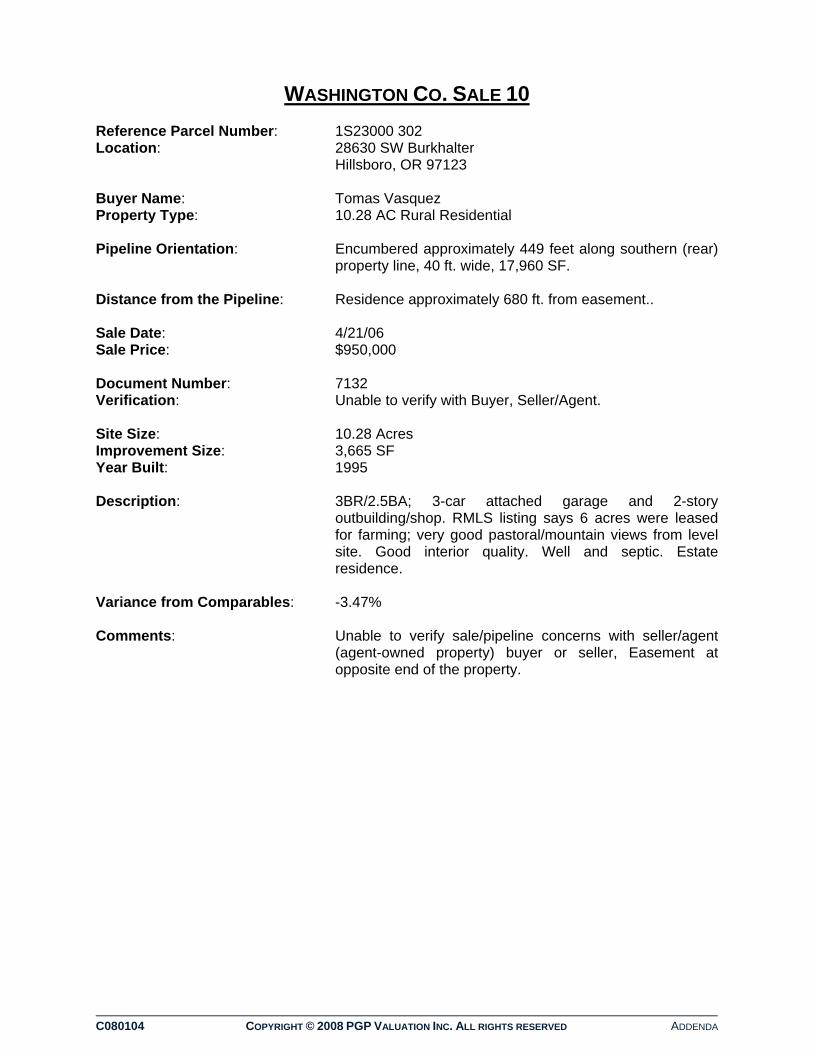
C080104 COPYRIGHT © 2008 PGP VALUATION INC. ALL RIGHTS RESERVED ADDENDA
WASHINGTON CO. SALE 10 Reference Parcel Number: 1S23000 302 Location: 28630 SW Burkhalter
Hillsboro, OR 97123 Buyer Name: Tomas Vasquez Property Type: 10.28 AC Rural Residential Pipeline Orientation: Encumbered approximately 449 feet along southern (rear)
property line, 40 ft. wide, 17,960 SF. Distance from the Pipeline: Residence approximately 680 ft. from easement.. Sale Date: 4/21/06 Sale Price: $950,000 Document Number: 7132 Verification: Unable to verify with Buyer, Seller/Agent. Site Size: 10.28 Acres Improvement Size: 3,665 SF Year Built: 1995 Description: 3BR/2.5BA; 3-car attached garage and 2-story
outbuilding/shop. RMLS listing says 6 acres were leased for farming; very good pastoral/mountain views from level site. Good interior quality. Well and septic. Estate residence.
Variance from Comparables: -3.47% Comments: Unable to verify sale/pipeline concerns with seller/agent
(agent-owned property) buyer or seller, Easement at opposite end of the property.

LOCATION SUBJECT COMPARABLE 1 COMPARABLE 2 COMPARABLE 3Owner: Tomas Vasquez Craig Lyman Farid Jame Neal NguyenAddress: 28630 SW Burkhalter Rd. 1205 NW Cavens Lane 21832 SW Scholls-Sherwood Rd. 10575 SW Grabhorn Rd.City, State: Hillsboro, OR Hillsboro, OR Sherwood, OR Aloha, ORCounty Washington Washington Washington WashingtonReference Parcel Number 1S23000 302 1N335A 600 2S21500 301 1S23600 300Assessor's Parcel No.: R0397485 R0756328 R0566934 R0399198SALE INFORMATION 5/26/2004Transaction Date: 21-Apr-06 1-Nov-06 7-Nov-06 13-Apr-06Transaction Price: $950,000 $975,000 $985,000 $989,000Improvement Adjustments:Time Adjustments:Analysis Price: $950,000 $975,000 $985,000 $989,000Recording Number: 47426 130186 132053 43601PHYSICAL CHARACTERISTICSProperty Type: Rural Residential Rural Residential Rural Residential Rural ResidentialSite Size (AC): 10.28 4.93 9.65 15.18Shape: Rectangular Rectangular Rectangular RectangularTopography: Level Level (Bench above floodplain) Level Level Access: Average Average - Gated Average AverageIMPROVEMENT CHARACTERISTICSYear Built 1995 1992 1964 1986Size (SF) 3,665 4,959 1,906 3,639Bedrooms 3 3 3 4Bathrooms 2.5 4.5 2 3.5Levels 2 2 1 2Main Floor 1,802 3,879 1,906 2,478Upper Level 1,863 1,080 0 1,161Basement 0 0 0 0Other Amenities Contemporary with 3-car attached.
Detached 2-car RV garage/shop with upper level attic. 6AC farm leased.
Traditional estate home overlooking 60AC floodplain. Pole barn, in-ground pool, wine cellar.
Well-maintained ranch and horse facility, arena, 18 stalls, pastures. 2-Car oversize. Outbuildings/shops, extra parking.
Tudor-style estate with 2-level barn, 2-car attached. Good views of valley and mountains.
Quality Good Good to Excellent Good GoodANALYSISSubject Sale Price: $950,000 $975,000 $985,000 $989,000Average of Comparable Sales Prices $983,000Difference in Price ($33,000)Subject Sales Price Variance -3.47%Days on Market 220 142Comments Estate home now listed on the market
for $1,150,000Estate home later sold for $1,100,000 Nov-2007
Addtl. 5-AC avail for pasture lease. Mature trees.
CONFIRMATIONConfirmation: Seller/agent did not return calls, No
number for buyer. Metroscan/RMLS listing data usedTelephone:
Date: February-08
WASHINGTON CO. SALE 10 SUMMATION TABLE

C080104 COPYRIGHT © 2008 PGP VALUATION INC. ALL RIGHTS RESERVED ADDENDA
EXCLUDED SALES TABULATION CHART

Owner & Location Owner & Location Sale Date Sale Price Size/AC Comments
Owner: Kate Gregory 4-Feb-05 $301,000 43.54Address: 24155 NW Dairy Creek RdCity, State: North Plains, OR 3BR 1BACounty Washington 1,496 SFReference Parcel Number 3N333C0 300 Blt. 1967Assessor's Parcel No.: R0821466
Owner: Timberline Baptist Church 9-Dec-04 $500,000 7.05Address: 24645 SW Old Highway 99WCity, State: Sherwood, OR Manufactured HomeCounty Washington No Additional ValueReference Parcel Number 3S201AO 700Assessor's Parcel No.: R0587626
Owner: Reid Family Enterprises 13-Aug-07 $995,000 6.80Address: 18790 SW Scholls-Sherwood Rd.City, State: Sherwood, OR 3BR/2BACounty Washington 3,216 SFReference Parcel Number 2S22400 506 Blt 1922 RestoredAssessor's Parcel No.: R0571900 24 Greenhouses
Owner: Spada Trust 23-Dec-04 $1,600,000 257.43Address: 28180 S. Oglesby Rd.City, State: Canby, OR 4BR/2BA, 3BR/2.5BACounty Clackamas 2,220 SF, 2,385 SFReference Parcel Number Various 1970, 1990Assessor's Parcel No.: Various
This is the sale of an nursery property. It is improved with two residences. Parcel numbers are as follows: 41E21 01800, 01900;1E28 00300, 00400, 00501, 00600, 00700, 00780. Transaction was an estate sale and seller was unusually motivated to sell, in order to avoid inheritance taxes. Very large property size and two residences make sales comparables not reliable.
The purchase of the Windmill Nursery in Sherwood that was described as “turnkey” for commercial operation and included multiple commercial greenhouses and processing structures as well as a single-family residence. This is a special purpose property with owner/user characteristics.
EXCLUDED SALES TABULATION CHART
Ms. Gregory was related to the seller and the purchase price was negotiated in 1999. Litigation filed by other family members delayed the recording of the sale until 2004. This is not considered an arm's length transaction.
site on the edge of the Urban Growth Boundary for Sherwood but was not expected to be available for urban expansion for many years. The property has an elongated triangular shape the limits development potential but has significant street frontage along Highway 99W. The existing manufactured home was moved for new construction of the church, which was a conditional use in the zoning district. The Timberline representative said they were looking for a site with proximity to an urban area and this property matched their needs. Overall, this site and the price paid on a per acre basis represented the motivation for a particular buyer and do not reflect market value for similar properties.

C080104 COPYRIGHT © 2008 PGP VALUATION INC. ALL RIGHTS RESERVED ADDENDA
QUALIFICATIONS OF PGP VALUATION INC
QUALIFICATIONS OF PGP VALUATION INC
PGP VALUATION INC
PGP VALUATION INC is a leading provider of real estate valuation and consulting services. Founded in 1978, PGP has offices in Atlanta, Boise, Calgary, Dallas, Edmonton, Halifax, Honolulu, Irvine, Las Vegas, Los Angeles, Phoenix, Portland, Sacramento, San Diego, Seattle, Toronto, Vancouver (BC), and Vancouver (WA). PGP’s partnership with Colliers Macaulay Nicholls, Inc (Colliers CMN), one of the largest commercial real estate services providers in the world, has expanded PGP’s ability to serve clients globally. PGP has extensive experience in a diverse range of commercial property appraisals, with an expertise in large portfolio valuations. With over 200 experienced appraiser professionals and an efficient commercial appraisal system, PGP has built a reputation for excellence, customer service and responsiveness. PGP’s comprehensive valuation reports are created using the most advanced analytical tools and recognized appraisal methods. PGP’s appraiser professionals adhere to the Code of Ethics established by the Appraisal Institute, and strive to maintain the highest level of professional integrity. PROFESSIONAL SERVICES PGP Valuation Inc offers a wide range of services related to the valuation of real estate: Appraisals: Single asset and portfolio valuations on all property types,
including residential, commercial, industrial, Low Income Housing Tax Credits (LIHTC), infrastructure and easements
Partial interest and business valuations Highest and Best Use Consultation regarding the most profitable utilization of real & Market Studies: property assets Feasibility and absorption studies of housing and commercial
developments
Preparation of FNMA condominium market studies and valuation Consultation: Analysis of real estate regarding values, site development
potential, market standards versus competitive edge amenities, market conditions, etc.
Litigation Support: Professional opinions as expert witnesses regarding the
valuation of real estate Property Tax Representation before government agencies regarding ad Analysis/Appeal: valorem taxes, including preliminary value consultation
appraisals and Board of Equalization presentations

PGP VALUATION INC OFFICE LOCATIONS - USA
PGP VALUATION INC
ATLANTA 3350 Riverwood Parkway Suite 1750 Atlanta, GA 30339 770.953.2082 Phone 770.953.2085 Fax Donald Johnson, MAI Senior Vice President & Regional Director Wallace White, MAI Senior Managing Director BOISE 910 Main Street Suite 354 Boise, ID 83702 208.342.0163 Phone 208.424.7767 Fax James Gibson Managing Director DALLAS 4311 Oak Lawn Avenue Suite 400 Dallas, TX 75219 214.599.9808 Phone 214.853.5900 Fax Stan Wolf, MAI Senior Managing Director Daniel Boring, MAI Senior Vice President, Business Development HONOLULU 1038 Queen Street Suite 2D Honolulu, HI 96814 808.591.2846 Phone 808.591.2848 Fax Bobby Hastings, MAI Senior Managing Director IRVINE One Park Plaza Suite 950 Irvine, CA 92614 949.253.9510 Phone 949.253.9075 Fax Bob Bell, MAI Senior Managing Director
LAS VEGAS 10161 Park Run Drive Suite 150 Las Vegas, NV 89145 702.835.6872 Phone 702.835.6873 Fax Jonathan Fletcher Senior Appraiser LOS ANGELES 865 South Figueroa Street Suite 3500 Los Angeles, CA 90017 213.532.3246 Phone 760.444.8123 Fax Kenneth Harrison, MAI President & CEO PHOENIX 2390 East Camelback Road Phoenix, AZ 85016 602.222.5000 Phone 602.222.5001 Fax Dennis Farr, MAI Senior Managing Director PORTLAND 110 SW Yamhill Street Suite 200 Portland, OR 97204 503.226.0983 Phone 503.273.4273 Fax Jeremy Snow, MAI Senior Managing Director Jeff Grose Managing Director Grant Norling Managing Director Donald Palmer, MAI Principal & Senior Team Leader SACRAMENTO 3000 Lava Ridge Court Suite 220 Roseville, CA 95661 916.724.5500 Phone 916.724.5600 Fax Cheryl Mandich Chief Financial Officer Robert Steed Managing Director
SAN DIEGO 5796 Armada Drive Suite 210 Carlsbad, CA 92008 877.720.2525 Phone 760.730.3372 Fax Phil Steffen, MAI Executive Vice President Russell McCoy, MAI Senior Managing Director Jared Mathews Managing Director Sean S. Yousofy Managing Director Kevin S. Ritter Managing Director SEATTLE 1325 4th Avenue Suite 500 Seattle, WA 98101 206.343.7477 Phone 206.682.7207 Fax John Campbell Managing Director Joe Creech Managing Director Reid Erickson Managing Director Cheryl Lotz Managing Director VANCOUVER (WA) 112 West 11th Street Suite 250 Vancouver (SFR), WA 98660 360.699.4844 Phone 360.699.1904 Fax Dean Meyer, MAI Senior Managing Director Steve Waugh Managing Director David Groth, MAI Senior Team Leader

PGP VALUATION INC OFFICE LOCATIONS - CANADA
PGP VALUATION INC
CALGARY 1000 Royal Bank Building 335 - 8 Avenue SW Calgary, AB T2P 1C9 403.265.9180 Phone 403.265.6495 Fax Chris Marlyn, AACI Managing Director EDMONTON 3555 Manulife Place 10180-101 Street Edmonton, AB T5J sS4 780.420.1585 Phone 780.424.7830 Fax Kenneth Duffin, AACI Managing Director
HALIFAX 1791 Barrington Street Suite 900 Halifax, NS B3J 3K9 902.422.1422 Phone 902.429.9866 Fax Mitch Wile Senior Manager TORONTO 1 Queen Street East Suite 2200 Toronto, ON M5C 2Z2 416.777.2277 Phone 416.643.3470 Fax Shawn Oakley, AACI Managing Director
VANCOUVER (BC) Granville Square 200 Granville Street Suite 1910 Vancouver, BC V6C 2R6 604.681.4111 Phone 604.661.0849 Fax Howie Charters, CLP, FRI Managing Director

C080104 COPYRIGHT © 2008 PGP VALUATION INC. ALL RIGHTS RESERVED ADDENDA
QUALIFICATIONS OF APPRAISERS

© PGP VALUATION INC
DONALD R. PALMER, MAI Principal
Don Palmer was born in Sunnyside, Washington in 1948. Don spent his early years in the lower Yakima Valley, graduating from Washington State University in 1970 with a Bachelor of Arts in Business Administration. Since graduating, he has resided in Portland, Oregon, and has been active in the Appraisal Institute, the Oregon Mortgage Bankers Association, the Portland Metro Building Owner's Association, Multnomah Athletic Club, and Tualatin Country Club.
Washington State University ♦ 1970 Bachelor of Arts Degree ♦ Business Administration
Washington Eminent Domain Conference ♦ 2005
Oregon Eminent Domain Conference ♦ 2005 - 2006
Principal ♦ PGP VALUATION INC (formerly Palmer, Groth & Pietka, Inc.) Real Estate Appraiser ♦ Curtis & MacKenzie
Appraiser ♦ Assessor's Office, Multnomah County, Oregon
Certified General Real Estate Appraiser ♦ State of Oregon Certificate No. C000060
Certified General Real Estate Appraiser ♦ State of Washington License No. 27011 1100446
Certified General Real Estate Appraiser ♦ State of California License No. AG042956
Appraisal Institute Oregon Mortgage Bankers Association
MAI ♦ Appraisal Institute
PROFESSIONAL EDUCATION
GUEST LECTURER
REAL ESTATE EXPERIENCE
LICENSE AND CERTIFICATION
PROFESSIONAL AFFILIATIONS
PROFESSIONAL DESIGNATIONS

© PGP VALUATION INC
Qualifications of Donald R. Palmer, MAI (Continued)
Board of Directors, 1983-1984 - Athletic Association, Portland State University Board of Directors, 1985-1986 - Parry Center
Board of Directors, 1987-1990 - Appraisal Institute President, 1989 - Appraisal Institute
Board of Directors, 1988-1989 - Oregon Mortgage Bankers Association Real Estate Advisory Committee - Boy Scouts of America
Board of Directors, 1987-1990 - Portland Metro Buildings & Owners Association Board of Directors, 1990-1991 - State of Oregon, Real Estate Agency
President, 1992 - Portland Metro Buildings, Owners, & Managers Association Cathedral School Board, 1991-1992
Board of Directors, President, Vice President, Treasurer, 1995 to 2001 – Tualatin Country Club SW Community Center Task Force, 1998 – City of Portland
Washington State University Planned Giving Advisory Board, 2002-Present St. Mary’s Auction Chairperson, 2002
Portland Metro Builders & Owners Association Member of the Year, 1985
COMMUNITY SERVICES
COMMUNITY AWARDS