unsustainable streams and wetlands mitigation costs in ... streams and wetland... · unsustainable...
TRANSCRIPT

Unsustainable Streams and Wetlands Mitigation Costs in Northern Kentucky
Current & Future Economic Development Projects are Threatened
• In-Lieu Fees for streams and wetlands mitigation have increased 176% since 2009
o Public sector costs equal at least $29.42M in mitigation fees since 1999
o Private sector costs are at least $6.39M over the last ten years
• Prospective projects may be lost due to mitigation costs that exceed the fair market value of the land
itself, in some cases doubling the cost to acquire land for development
Actionable Solutions
CHANGE HOW FUNDS ARE USED
• Use mitigation funds for needed sewer system expansions, repairs and replacements to better improve
our water quality by eliminating sanitary sewer overflows from our streams
CHANGE HOW PROJECTS ARE EVALUATED
• Add development industry leaders to the Kentucky Interagency Review Team for streams and wetlands
project review
• Ease overly-aggressive inspections and use best management practices that do not unduly burden property owners
• Require public reporting of tax dollars spent on streams and wetlands mitigation and use a database to
track cost, impact and outcomes for mitigation projects
• Determine a more concrete definition of “Waters of the U.S.” and “nexus”
CHANGE HOW COSTS ARE INCURRED
• Freeze or reduce costs through moratoriums, alternative agency jurisdictions, creation of a new streams and wetlands bank, or regulatory relief from the US Army Corps of Engineers or US EPA
CHANGE CONTROL OF FEDERAL MANDATES TO STATE BASED PROGRAMS
• Allow the Commonwealth to create and administer an EPA Section 404 program rather than administer a
Federal mandate
Authors
This white paper was authored collaboratively by:
• Building Industry Association of Northern Kentucky
• Northern Kentucky Chamber of Commerce
• Tri-County Economic Development Corporation (Northern Kentucky Tri-ED)
Questions should be directed to:
Economic Development Impacts
Daniel E. Tobergte, CEcD
President/CEO
Northern Kentucky Tri-ED
859.750.4041
Construction/Development Impacts
Brian Miller
Executive Vice President
Building Industry Association, NKY
859.653.4815
Legislative Impacts
Kristin BaldwinVice President, Public Affairs
NKY Chamber of [email protected]
Unsustainable Streams and Wetlands Mitigation Costs in Northern Kentucky
The development community in the Northern Kentucky region, comprised of developers, engineers, commercial real estate brokers, industrial users, financial institutions, etc., have expressed grave concerns to the Building Industry Association of Northern Kentucky, the Northern Kentucky Chamber of Commerce and the Tri-County Economic Development Corporation (Northern Kentucky Tri-ED) about the length of time to permit and the quick escalation of in-lieu fees to mitigate impacts to streams and wetlands on industrial, commercial, and residential sites.
In Northern Kentucky, nearly all expansion and new development projects for industrial, commercial and residential uses require stream mitigation due to the typical rolling terrain of Northern Kentucky and the current, aggressive interpretation of what was only recently considered regulated waterways. Public projects funded by taxpayer and ratepayer dollars are mandated to comply with the same program.
The recent increases in the cost of mitigation in Northern Kentucky have grown well beyond practicality and, as a direct result, are significantly inhibiting current and future development in Boone, Campbell, and Kenton counties in Northern Kentucky. Northern Kentucky development opportunities are imperiled due to the rise in these mitigation fees, especially when compared to neighboring areas in the Midwest and the South. This white paper is authored by the Building Industry Association of Northern Kentucky, the Northern Kentucky Chamber of Commerce, and Northern Kentucky Tri-ED with the intent of describing the current, unsustainable status of the Waters of the U.S. (WOTUS), its impact relating to streams and wetlands mitigation in Northern Kentucky and includes specific recommendations to alleviate these impacts.
Overview of the Waters of the United States in Northern Kentucky: Under current regulations, there are three mechanisms for providing compensatory mitigation for development projects in Northern Kentucky that affect either streams or wetlands listed in order of preference: mitigation banks, in-lieu fee programs, and permittee-responsible mitigation.
In Northern Kentucky, the Northern Kentucky University Center for Environmental Restoration (NKUCER) operates the Northern Kentucky Stream and Wetland Restoration Program (NKSWRP) under an agreement with the U.S. Army Corps of Engineers (USACE), Louisville District office. The NKSWRP provides an in-lieu fee compensatory mitigation option to public and private entities that impact aquatic ecosystems as determined by the USACE. The NKSWRP Compensation Planning Framework is contained in Appendix A. An NKSWRP Advisory Committee was formed in October, 2015 with Boone County Judge-Executive Gary Moore as Chair to provide input to Northern Kentucky University on the impacts of the NKSWRP on the
1 Unsustainable Streams and Wetlands Mitigation Costs in Northern Kentucky
2 Unsustainable Streams and Wetlands Mitigation Costs in Northern Kentucky
development community and to improve the efforts of the NKSWRP to develop affordable in-lieu fees (see Appendix B).
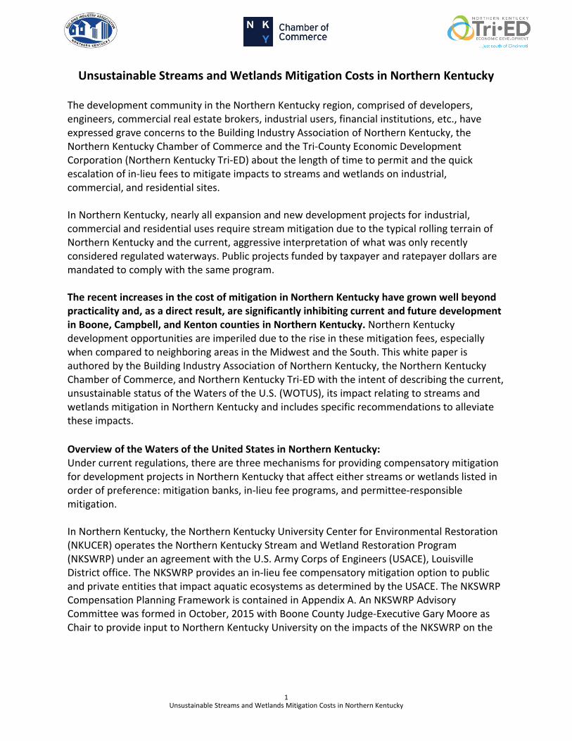
Since 2009, the in-lieu fees per adjusted mitigation unit (AMU) for streams and wetlands mitigation in Northern Kentucky have drastically increased, rising to $470/AMU, which is 57% higher than the current market rate in Kentucky and Ohio which stands at $300/AMU, thus negatively impacting companies looking to develop land in Northern Kentucky (see Chart 1).
Chart 1. Northern Kentucky Stream and Wetland Restoration Program In-Lieu Fee Rates
Year Fee per Adjusted Mitigation Unit (AMU)
% Change
2009 $170 -
2012 $215 +26%
2013 $240 +12%
2014 $296 +23%
2015 $470 +59%
2016 $470 +0%
Overall, a 176% increase since 2009
Source: NKSWRP (values derived from their respective annual report years)
Source: NKSWRP (values derived from their respective annual report years)
0
100
200
300
400
500
2009 2010 2011 2012 2013 2014 2015 2016 2017
Fee
per
AM
U (
$)
Year
Northern Kentucky Stream and Wetland Restoration Program In-Lieu Fee Rates
3 Unsustainable Streams and Wetlands Mitigation Costs in Northern Kentucky
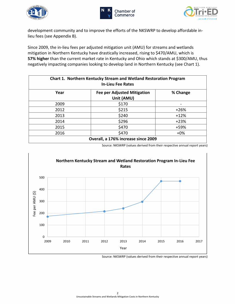
The 2016 Annual Report highlights the total in-lieu fees through December of 2016 to be approximately $34.8 million (Appendix B, page 2 in Annual Report). This report also details each project that undertook mitigation efforts and the cost associated with each project (Appendix B, pages 9-13 in the 2016 Annual Report).
Source: NKSWRP (values derived from their respective annual report years)
Taxpayers have paid $29.4M in rates and taxes since 1999, and over the last ten years the private industry has paid $6.4M (Appendix B). There has been, and continues to be, a disproportionate burden placed on taxpayers for these mitigation costs.
-
500,000
1,000,000
1,500,000
2,000,000
In-L
ieu
Fee
s ($
)
Year
Northern Kentucky Stream and Wetland Restoration Program Total Private In-Lieu Fees
4 Unsustainable Streams and Wetlands Mitigation Costs in Northern Kentucky
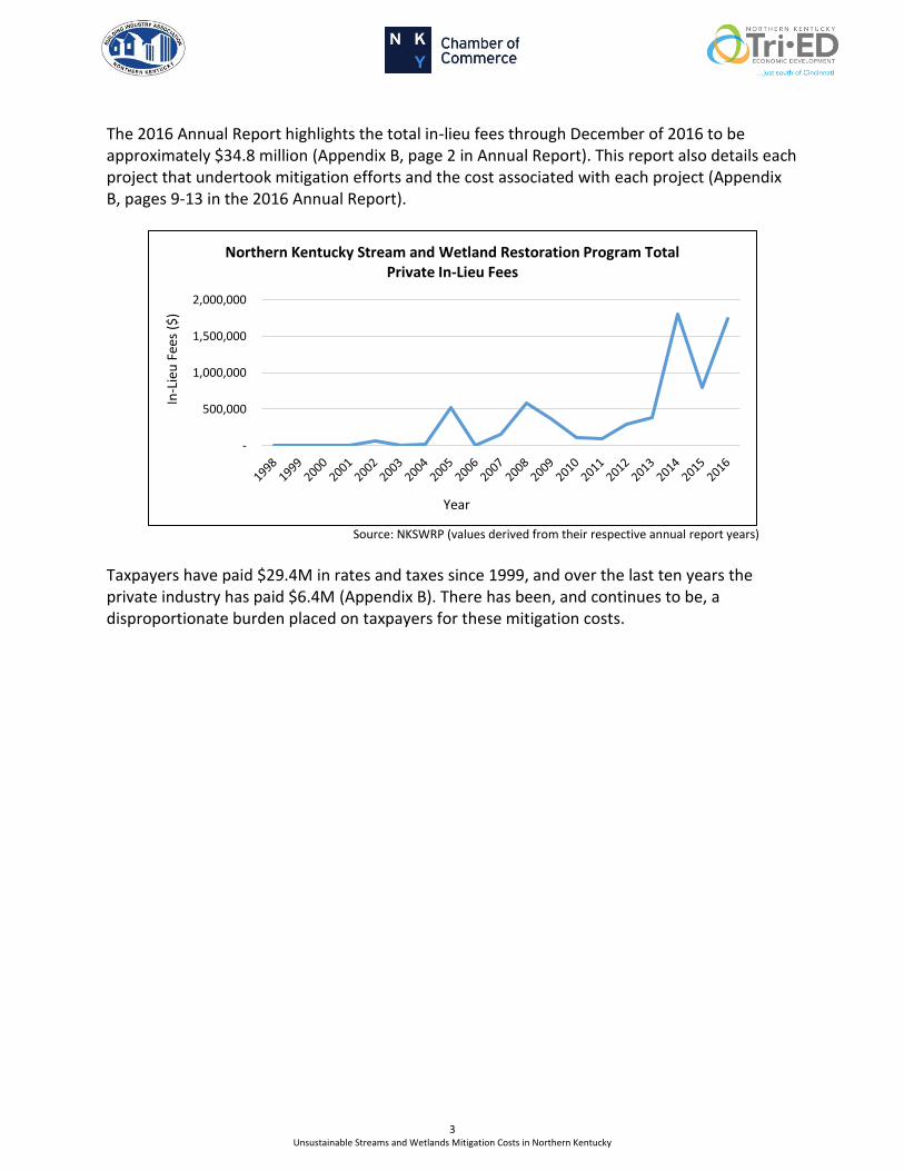
Developments Affected by Streams and Wetlands Mitigation in Northern Kentucky The projects below are a sample of developments where streams and wetlands mitigation costs through the NKSWRP have greatly affected the cost of the project.
Development Year* Project Acres
Streams and Wetlands
Mitigation Costs
Mitigation Cost/Acre
Fair Market Value/Acre
Kenton County Airport Board
(Wayfair) 2015 47 $593,400 $12,625 $60,000
Kenton County Airport Board
(Bosch) 2016 11 $774,000 $70,400 $90,000
FedEx NKY Hub Facility 2016 80 $748,000 $9,350 $87,500
Al Neyer 2016 49 $580,000 $11,800 $70,700
Lyons Magnus East Inc. 2016 17 $409,400 $24,100 $51,000
*Year recorded with the USACESources: Northern Kentucky Stream and Wetland Restoration Program, Table 2 (2016), CVG
These projects demonstrate the burdensome costs forced upon developers in Northern Kentucky through this program. The average streams and wetlands mitigation cost from projects provided in this table is $15,200 per acre. This produces an additional cost and substantial deterrent for developers. For additional projects affected by streams and wetlands mitigation please see the Northern Kentucky Stream and Wetland Restoration Program Annual Report in Appendix B.
5 Unsustainable Streams and Wetlands Mitigation Costs in Northern Kentucky
Prospective Developments This table gives examples of prospective projects that are pending due to the excessive streams and wetlands mitigation costs that are required if they wish to develop the land. These projects could potentially be lost solely due to mitigation costs.
Prospective Projects Year* Project Acres
Projected Streams and Wetlands
Mitigation Costs
Mitigation Cost/Acre
Fair Market Value/Acre
Kenton County Airport Board
2015 300 $13M-$15M $50,000 $45,000
Walton Industrial Park 2016 290 $4M-$6M $20,700 $15,000
*Year evaluated by the USACESources: CVG, Cushman & Wakefield
This table exemplifies that mitigation expenses are extreme and disproportionate, as the mitigation cost exceeds the market value of the land itself.
An additional development that will be occurring in Northern Kentucky is the Amazon air cargo hub for Amazon Prime Air. This 900-acre project, with a $1.5 billion capital investment, is undoubtedly going to be strained by streams and wetlands mitigation.
Prominent Issues and Proposed Solutions Secretary Charles G. Snavely of the Kentucky Energy and Environment Cabinet was briefed on the status of the streams and wetlands mitigation impact in Northern Kentucky by Brian Miller from the Building Industry Association of Northern Kentucky. Our community is seeking support for the following actions to alleviate the drastic consequences of this program:
1) Using mitigation funds for sewer system expansions, repairs, and replacementsa. This was expressed in a joint resolution of the legislature in 2012
(see Appendix C). Subsequently, Senator John Schickel filed SB 203 (Appendix D) which intended to result in the same. The Secretary agreed that available Clean Water Act (CWA) funds, under any section, should be used to the greatest ability to reduce negative impacts to the environment and human health.He agreed addressing raw sewage serves the greater good and that the funds needed to comply with federal consent decrees are not readily available to sanitation districts. To address this, he suggests that some streams restoration and wetlands restoration project funds should be used for these consent decree issues. He indicated that the argument that these are two separate sections of the CWA is irrelevant.
6 Unsustainable Streams and Wetlands Mitigation Costs in Northern Kentucky
2) A seat at the table for streams and wetlands mitigation projects through the Interagency Review Team (IRT)
a. There is a need for industry presence, implement an economic review team including private industry.
b. The lack of industry representation on the IRT is an issue. This can be solved by adding development representatives on the IRT to provide a practical approach to the implementation of administrative rules and regulations considering the economic feasibility and practicality of the impact of streams and wetlands mitigation rules and regulations.
3) Post construction maintenance of water quality Best Management Practices (BMP’s)a. Focus on lessening requirements and not burdening property owner.b. Progress has already been made in the Draft Phase II Small Municipal Separate
Storm Sewer System (MS4) Kentucky Pollutant Discharge Elimination System(KPDES) permit. The property owners are placed in the position to be saddled with the monitoring, maintenance, repair and replacement of thesesystems. We need an effort to have cities, counties or preferably, the MS4 to take these systems over. Not only are they the experts, but they also have the equipment to adequately address these systems in a proactive manner unlike the property owners, who would have to defer to experts; thereby making the solution for the systems’ future issues far more expensive and intensive. This could be done in concert with the MS4 receiving an apportionment of future Stream Restoration Project and Wetland Restoration Project funds.
4) Construction BMP’s and inspectionsa. Need to ease off aggressive inspections and lessen the amount and intensity of
required BMP’s.b. The Secretary agreed that there is little use for overly aggressive inspections,
such as inspectors waiting to inspect until immediately after a rainfall. Direction needs to be given to ease the tenacity of inspection personnel.
5) Require public reporting of tax money spent on streams mitigation by each department in the Commonwealth
a. Understand where the money is spent.b. Create a comparative database to inform the legislators/congressional delegation
of variances in implementation, cost, and adverse impact to each part of the Commonwealth. The intent being to demonstrate how much taxpayer money is used to fund the program.
6) Utilize Kentucky Division of Water streams designations as a basis for initial review of streams and wetlands
a. Do not require Army Corps of Engineers evaluation for every stream.b. Test the database to determine functionality.
7 Unsustainable Streams and Wetlands Mitigation Costs in Northern Kentucky
7) Utilize the State's Division of Water classification systema. Determine if the State’s Division of Water has a classification system in place
which can be used to define what is a “Water of the U.S” and which have a“Nexus.”
b. The uncertainty of the timeframe needed by the USACE to evaluate a propertyprior to development, as well as the uncertainty of which streams will beclassified, slows the speed to market and creates a significant delay on projects.
8) Allow the Commonwealth to create and administer an EPA Section 404 programa. A report was submitted in May, 2017 by the “Assumable Waters Subcommittee”
(Appendix E). The conclusion, in brief, by the stakeholders involved in thesubcommittees work is that the U.S. Army Corps of Engineers should retainjurisdiction over waters originally assigned to it in the Rivers and Harbors Act toaddress compliance with Section 404 of the Clean Water Act and including up to300 feet of adjacent waters thereto. These waters represent flowing streams,rivers and harbors where actual commerce is currently taking place. The findingsin the majority of the subcommittee are that all other waters shall be controlledby the states and that the states shall create and administer their own programsand not merely administer a federally mandated program. The EPA and USACOEare currently reviewing the report and have pledged to give it its dueTheconsideration. On several occasions in the media it has been reported thatthe Governor of the Commonwealth would agree to create and administer aKentucky program for these waters.
Proposed Alternatives to Reduce Costs The Northern Kentucky Stream and Wetland Restoration Program (NKSWRP) Advisory Committee met in October 2015 at Northern Kentucky University to learn more about the NKSWRP and discuss potential alternatives to reduce the escalating costs.
Alternatives Comments Reduce NKSWRP Fees Discussed with NKU – not tenable per NKU
Freeze NKSWRP Fees for 2 years Discussed with NKU – not tenable per NKU
Utilize KY Fish & Wildlife The US Army Corps of Engineers recently proposed a revision to the KY F&W jurisdiction to include Northern Kentucky.
Create new streams and wetlands mitigation bank in NKY
Under consideration by NKY development community
Seek regulatory relief from US Army Corps/US EPA
Discussed locally but not with US Army Corps nor U.S. EPA

Overview of Waters of the United States (WOTUS) Clean Water Rule: A new Clean Water Rule was established in August of 2015 that aimed to streamline the analysis process through the development of categorical classifications of waters and wetlands. The rule has the potential to reduce documentation requirements and time frames by decreasing the need for case specific analysis. The Clean Water Rule established eight categories of jurisdictional waters:
1. Traditional Navigable Waters2. All interstate waters, including interstate wetlands3. Territorial Seas4. Impoundments of Waters of the U.S.5. Covered tributaries, tributaries of 1-3 above (waters that flow directly to or through
another water and connect to a water body identified in 1-3)6. Covered adjacent waters, all waters adjacent (within 100 feet of the high-water
mark) to waters identified in 1-57. Five types of waters that have been determined to be “similarly situated” through a
significant nexus analysis: Prairie potholes, Delmarva and Carolina Bays, pocosins,Western vernal pools in California, and Texas costal prairie wetlands
8. Waters located within the 100-year FEMA floodplain of 1-3 above and waterslocated within 4,000 feet of the high tide line or ordinary high water mark of 1-5above
Waters described in 7 and 8 may be found to have a significant nexus on a case-specific basis, while 1-6 are jurisdictional by rule and do not require any additional analysis.
*Source for 1-8 water descriptions is: Terracon Winter 2016 Newsletter
Conclusion The conversation of this pressing issue is already occurring at the federal level with President Trump’s recently signed Executive Order regarding the 2015 Clean Water Rule. President Trump has directed the EPA to develop a new WOTUS rule that follows Justice Scalia’s decision in the Rapanos v. United States Supreme Court ruling. However, change at the federal level may take years, and these current regulations are having a significant negative impact on the region today; thus, there is a need for immediate action.
We now ask our state officials to assist in reducing the AMU costs affecting the Northern Kentucky region. This reduction could result by allowing the Northern Kentucky region to utilize alternative sources for credits such as Kentucky Fish and Wildlife, or a new mitigation bank, as well as having regulatory relief from the United States Army Corps of Engineers and the United States EPA. We encourage the state of Kentucky to take action in forming a community lobbying effort to reduce these importunate regulations affecting the Commonwealth. These substantial barriers have created, and are continuing to create, a negative business climate in the Northern Kentucky region.
8 Unsustainable Streams and Wetlands Mitigation Costs in Northern Kentucky
9 Unsustainable Streams and Wetlands Mitigation Costs in Northern Kentucky
The Building Industry Association of Northern Kentucky, the Northern Kentucky Chamber of Commerce, and Northern Kentucky Tri-ED have proposed these solutions to alleviate the burden companies and developers encounter with these regulations. These organizations are committed to being a resource to the EPA as it goes about the important work of developing a rule that will balance the protection of the environment and economic development.
Appendix A: The NKSWRP Compensation Planning Framework (28 pages)

1
Compensation Planning Framework
Northern Kentucky Stream and Wetland Restoration Program
February 2012 (Future proposed changes in red)
LRL-2010-326-pgj
This Compensation Planning Framework (CPF) addresses the requirements of 33 CFR 332.8[c], and describes how the Northern Kentucky Stream and Wetland Restoration Program (NKSWRP), using a watershed-based approach, will select in-lieu fee mitigation project sites to compensate for aquatic resource impacts. The NKSWRP is described at http://environmentalrestoration.nku.edu/program.html.The NKSWRP is also referred to as the NKU Stream Program.
Figures and Tables referenced in the text are provided at the end of this document.
I. SERVICE AREA
The NKSWRP serves a single Service Area encompassing the northern Kentucky region, a region which shares common characteristics including physiography, Ecoregions, topography, land use, historic and current stream impairments, wildlife preservation prioritization, and community and governmental natural resource management partnerships.
The core of the Service Area is comprised of the nine northern-most Kentucky counties: Boone, Kenton, Campbell, Carroll, Gallatin, Grant, Pendleton, Bracken, and Mason. These counties are readily accessible from NKU for project implementation (approximately one hour or less travel time, thus facilitating utilization of NKU student interns), and have the closest cultural ties to NKU and the northern Kentucky metropolitan area. At present the NKSWRP is the only in-lieu fee program serving the nine core Service Area counties. The remainder of the state is served by Kentucky Division of Fish and Wildlife.
Outlying counties of the northern Kentucky region and within the NKSWRP Service Area include particularly Oldham, Trimble, Henry, Owen, Harrison, Robertson and Nicholas. These counties are within the same major watersheds (Ohio River Tributaries, Licking, and/or Kentucky), and the same Level IV Ecoregions as the core Service Area counties (Outer Bluegrass and Hills of the Bluegrass). Fleming and Lewis Counties to the east are also within the same major watersheds as the core Service
2
Area counties, but include significant portions of an additional Ecoregion (Knobs-Lower Scioto Dissected Plateau). Outlying counties are more rural and provide a greater opportunity to create larger, more consolidated mitigation projects. The outlying counties are served by both the NKSWRP and the KDFWR in-lieu fee programs.
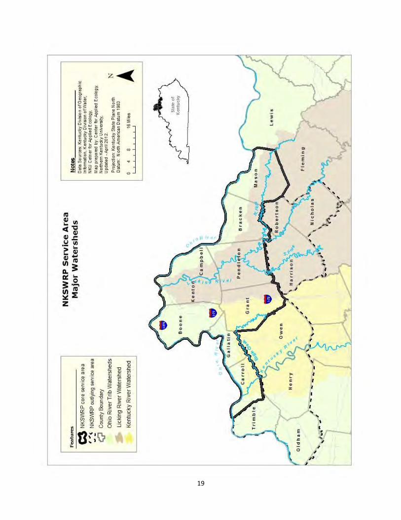
A. MAJOR WATERSHEDS
The NKSWRP Service Area includes portions of three major watersheds: Ohio River Tributaries (streams that drain directly to the Ohio River); the Licking River, and the Kentucky River. A map illustrating the major watersheds is attached. In order of predominance, the Licking River watershed constitutes about 51 percent of the Service Area core counties, versus 36 for Ohio River Tributaries, and 13 percent for the Kentucky River watershed. The Eagle Creek watershed constitutes nearly the entire Kentucky River watershed within the Service Area core counties.
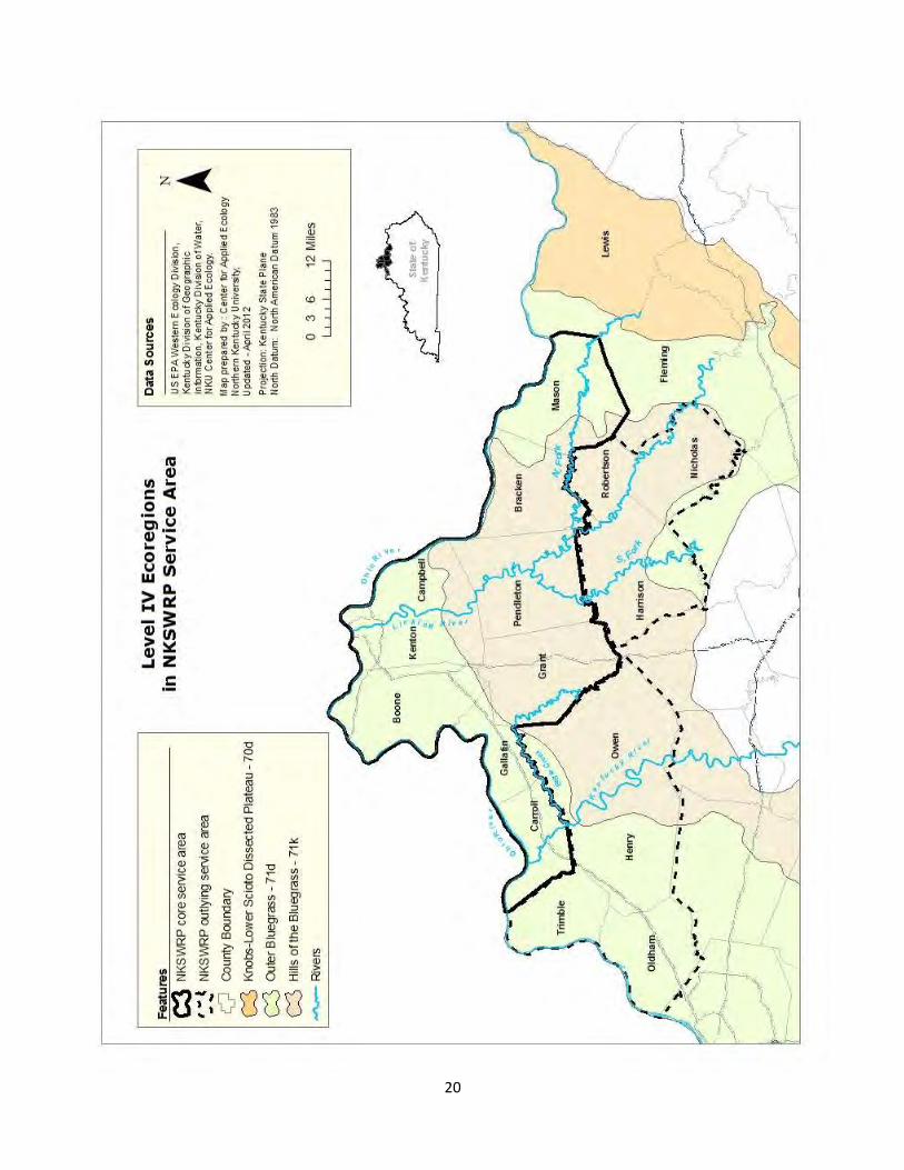
B. ECOREGIONS
At the Level IV Ecoregion scale, the Service Area core counties include approximately equal proportions of two similar ecoregions: Outer Bluegrass (71d): most of Carroll, Gallatin, Boone, Kenton, Campbell, and Mason Counties Hills of the Bluegrass (71k): most of Grant, Pendleton, and Bracken Counties
The next tier northern Kentucky counties are also predominantly within these same Ecoregions, except the Knobs-Lower Scioto Dissected Plateau (70d) Ecoregion constitutes a significant proportion of Fleming County (approx. 30%) and Lewis County (approx. 70%).
A map illustrating the Level IV Ecoregions is attached. They are characterized as follows:
71d. Outer Bluegrass. The rolling to hilly Outer Bluegrass (71d) contains sinkholes, springs, entrenched rivers, and intermittent and perennial streams. Local relief is variable. Discontinuous glacial outwash and leached, pre-Wisconsinan till deposits occur in the north from Louisville to Covington. Glacial deposits do not occur elsewhere in Kentucky. Ecoregion 71d is mostly underlain by Upper Ordovician limestone and shale. Natural soil fertility is higher than in the shale-dominated Hills of the Bluegrass (71k). Today, pastureland and cropland are widespread and dissected areas are wooded. At the time of settlement, open savanna woodlands were found on most uplands. On less fertile, more acidic soils derived from Silurian dolomite, white oak stands occurred and had barren openings. Cane grew along streams and was especially common in the east. Distinct vegetation grew in areas underlain by glacial drift. Upland streams have moderate to high gradients and cobble, boulder, or bedrock substrates. Mean stream density is less than in Ecoregion 71k. Concentrations of suspended sediment and nutrients can be high. 71k. Hills of the Bluegrass. The mostly forested Hills of the Bluegrass (71k) are underlain by Upper Ordovician calcareous shale, siltstone, and limestone. It is lithologically unlike the Outer Bluegrass (71d).
3
Upland soils are fairly high in phosphorus, potassium, and lime but are not as naturally fertile as Ecoregion 71d; they support young, mixed forests rich in white oak, hickory, and cedar. The Hills of the Bluegrass (71k) has steeper terrain, droughtier soils, lower soil fertility, higher drainage density, and is more erosion-prone than Ecoregion 71d. As a result, less than ten percent of Ecoregion 71k is suited to row crop agriculture and the rest is wooded, pastureland, or hayland. Stream nutrient levels are generally lower than in Ecoregions 71d. Upland streams are often intermittent and have cobble, boulder, or bedrock substrates. Fish and macroinvertebrate assemblages are similar to Ecoregions 71d. 70d. Knobs–Lower Scioto Dissected Plateau contains rounded hills and ridges, narrow valleys with high gradient streams, and a few wide, locally swampy, bottoms underlain by weak shales. Cliffs occur especially in the south. High amounts of topographic and geologic variation are typical and create substantial ecological diversity. Ecoregion 70d is underlain by a mixture of Pennsylvanian-age through Silurian-age sedimentary rocks that is absent from the rest of Ecoregion 70. Ecoregion 70d is geographically adjacent and ecologically connected to the Western Allegheny Plateau (70) and, as such, is not a part of the Interior Plateau (71). Uplands knobs are forested and oak and oak–pine forests predominate. Broad valleys are mostly covered by bottomland forests but some are used for livestock or general farming. Elevation, local relief, and forest density are much greater than in Ecoregions 71d and 71k. Nutrient and ionic concentrations in streams are lower than in Ecoregions 71d. No coal mining or related stream acidity problems occur.
Descriptions are adapted from: ftp://ftp.epa.gov/wed/ecoregions/ky/ky_front.pdf
II. HISTORIC LOSSES AND THREATS TO AQUATIC RESOURCES
A. WETLANDS
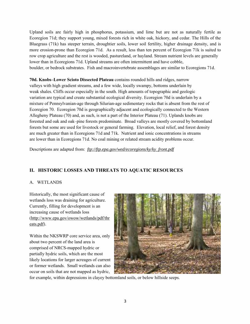
Historically, the most significant cause of wetlands loss was draining for agriculture. Currently, filling for development is an increasing cause of wetlands loss (http://www.epa.gov/owow/wetlands/pdf/threats.pdf). Within the NKSWRP core service area, only about two percent of the land area is comprised of NRCS-mapped hydric or partially hydric soils, which are the most likely locations for larger acreages of current or former wetlands. Small wetlands can also occur on soils that are not mapped as hydric, for example, within depressions in clayey bottomland soils, or below hillside seeps.
4
During the first 11 years of operation, less than one acre of wetlands loss was mitigated through the NKSWRP. Nevertheless, wetlands have been created or enhanced as a component of previous stream restoration projects, since wetlands are an integral part of stream quality and function (floodwater detention, pollutant removal, groundwater recharge, amphibian habitat, etc.).
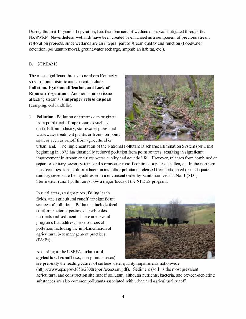
B. STREAMS
The most significant threats to northern Kentucky streams, both historic and current, include Pollution, Hydromodification, and Lack of Riparian Vegetation. Another common issue affecting streams is improper refuse disposal (dumping, old landfills).
1. Pollution. Pollution of streams can originate
from point (end-of-pipe) sources such as outfalls from industry, stormwater pipes, and wastewater treatment plants, or from non-point sources such as runoff from agricultural or urban land. The implementation of the National Pollutant Discharge Elimination System (NPDES) beginning in 1972 has drastically reduced pollution from point sources, resulting in significant improvement in stream and river water quality and aquatic life. However, releases from combined or separate sanitary sewer systems and stormwater runoff continue to pose a challenge. In the northern most counties, fecal coliform bacteria and other pollutants released from antiquated or inadequate sanitary sewers are being addressed under consent order by Sanitation District No. 1 (SD1). Stormwater runoff pollution is now a major focus of the NPDES program.
In rural areas, straight pipes, failing leach fields, and agricultural runoff are significant sources of pollution. Pollutants include fecal coliform bacteria, pesticides, herbicides, nutrients and sediment. There are several programs that address these sources of pollution, including the implementation of agricultural best management practices (BMPs).
According to the USEPA, urban and agricultural runoff (i.e., non-point sources) are presently the leading causes of surface water quality impairments nationwide (http://www.epa.gov/305b/2000report/execsum.pdf). Sediment (soil) is the most prevalent agricultural and construction site runoff pollutant, although nutrients, bacteria, and oxygen-depleting substances are also common pollutants associated with urban and agricultural runoff.

5
2. Hydromodification. Hydromodification (aka hydrology modification) refers primarily to deliberate, physical alterations of a stream, and has been a common practice in both rural and urban landscapes. Once completed, most stream channel alterations are poorly maintained or not maintained at all, which exacerbates the negative impacts. Specific examples of deliberate stream hydromodification include:
Channelization: channel straightening,
concrete lining, dredging and/or relocation Damming Hard bank armoring: sheetpile, concrete, demolition debris, refuse Culvertizing: piping, encasement Floodplain and/or channel encroachment: filling, levee construction Undersized and/or misaligned stream crossings (culverts, low water crossings, etc.)
Hydromodification can also refer to stream channel erosion due to modified landuse. Land clearing for agriculture results in reduced rainfall retention (loss of topsoil, un-vegetated soil, reduced evapotranspiration). Similarly, urban development results in impervious surfacing, stormwater concentration into pipes, and soil compaction. Both agricultural and urban development increase and concentrate stormwater runoff, resulting in channel erosion as receiving streams must adjust to create more channel capacity.
Hydromodification results in stream and riparian habitat loss, stream bank erosion, channel incision and/or scouring, slope failures, sedimentation/siltation of aquatic habitat, infrastructure damage, disconnection from the floodplain, downstream flooding, increased stream temperatures, increased light levels and other problems.
3. Lack of Riparian Vegetation. A buffer of native vegetation along stream corridors provides numerous benefits to streams such as organic material inputs (food web), aquatic and riparian habitat, temperature moderation, channel roughness (stream energy dissipation), nutrient and sediment removal, and bank protection (root reinforcement). The removal of native riparian vegetation, for example by forest clearing, livestock grazing, or mowing to the edge of banks, forfeits these benefits. The most obvious impairment associated with loss of riparian vegetation is bank erosion resulting in stream sedimentation/siltation. Where riparian vegetation is allowed to recover after removal, although bank stability generally improves, invasive/non-native plants and low biodiversity often reduces the quality of the riparian buffer compared to pre-disturbance conditions.

6
7
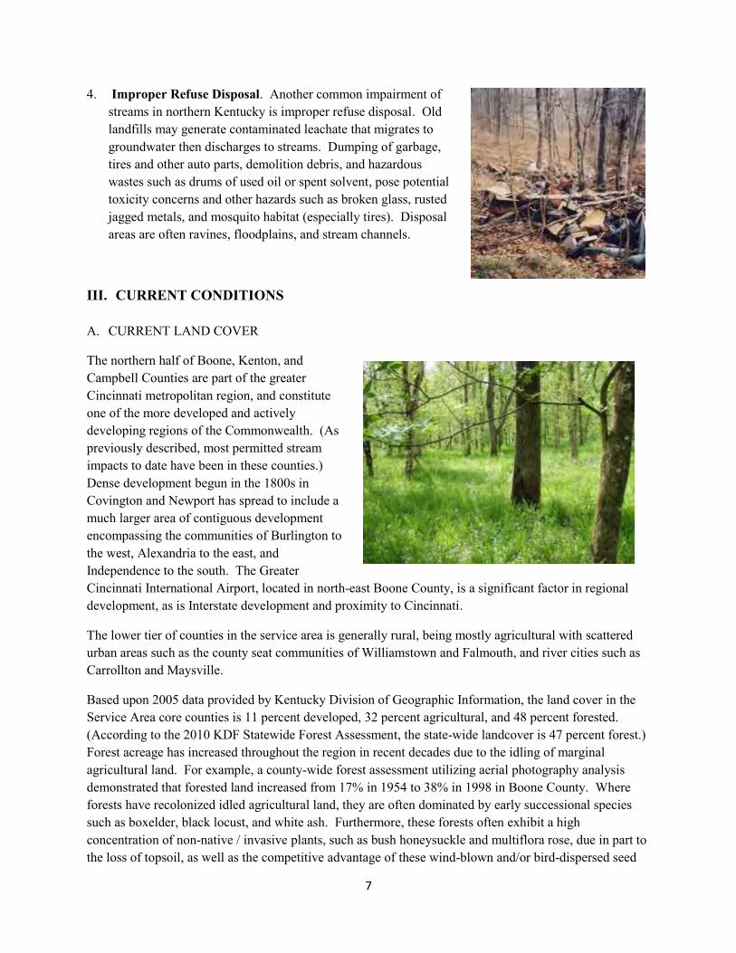
4. Improper Refuse Disposal. Another common impairment of streams in northern Kentucky is improper refuse disposal. Old landfills may generate contaminated leachate that migrates to groundwater then discharges to streams. Dumping of garbage, tires and other auto parts, demolition debris, and hazardous wastes such as drums of used oil or spent solvent, pose potential toxicity concerns and other hazards such as broken glass, rusted jagged metals, and mosquito habitat (especially tires). Disposal areas are often ravines, floodplains, and stream channels.
III. CURRENT CONDITIONS
A. CURRENT LAND COVER
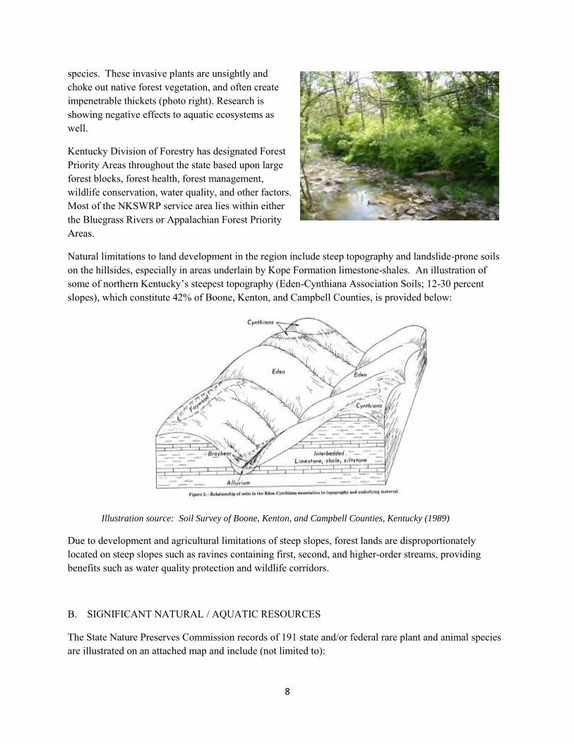
The northern half of Boone, Kenton, and Campbell Counties are part of the greater Cincinnati metropolitan region, and constitute one of the more developed and actively developing regions of the Commonwealth. (As previously described, most permitted stream impacts to date have been in these counties.) Dense development begun in the 1800s in Covington and Newport has spread to include a much larger area of contiguous development encompassing the communities of Burlington to the west, Alexandria to the east, and Independence to the south. The Greater Cincinnati International Airport, located in north-east Boone County, is a significant factor in regional development, as is Interstate development and proximity to Cincinnati.
The lower tier of counties in the service area is generally rural, being mostly agricultural with scattered urban areas such as the county seat communities of Williamstown and Falmouth, and river cities such as Carrollton and Maysville.
Based upon 2005 data provided by Kentucky Division of Geographic Information, the land cover in the Service Area core counties is 11 percent developed, 32 percent agricultural, and 48 percent forested. (According to the 2010 KDF Statewide Forest Assessment, the state-wide landcover is 47 percent forest.) Forest acreage has increased throughout the region in recent decades due to the idling of marginal agricultural land. For example, a county-wide forest assessment utilizing aerial photography analysis demonstrated that forested land increased from 17% in 1954 to 38% in 1998 in Boone County. Where forests have recolonized idled agricultural land, they are often dominated by early successional species such as boxelder, black locust, and white ash. Furthermore, these forests often exhibit a high concentration of non-native / invasive plants, such as bush honeysuckle and multiflora rose, due in part to the loss of topsoil, as well as the competitive advantage of these wind-blown and/or bird-dispersed seed
8
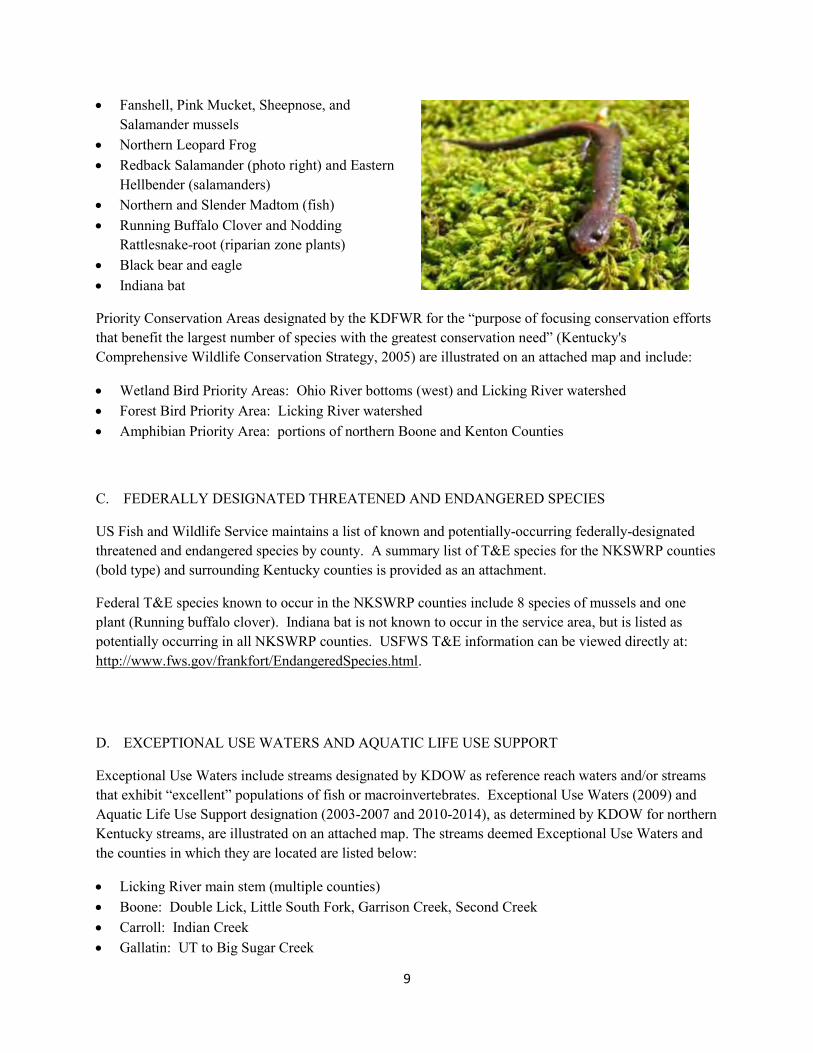
species. These invasive plants are unsightly and choke out native forest vegetation, and often create impenetrable thickets (photo right). Research is showing negative effects to aquatic ecosystems as well.
Kentucky Division of Forestry has designated Forest Priority Areas throughout the state based upon large forest blocks, forest health, forest management, wildlife conservation, water quality, and other factors. Most of the NKSWRP service area lies within either the Bluegrass Rivers or Appalachian Forest Priority Areas.
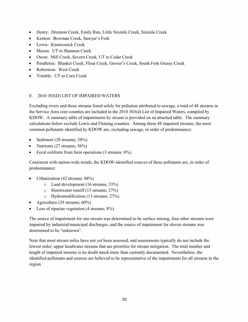
Natural limitations to land development in the region include steep topography and landslide-prone soils on the hillsides, especially in areas underlain by Kope Formation limestone-shales. An illustration of some of northern Kentucky’s steepest topography (Eden-Cynthiana Association Soils; 12-30 percent slopes), which constitute 42% of Boone, Kenton, and Campbell Counties, is provided below:
Illustration source: Soil Survey of Boone, Kenton, and Campbell Counties, Kentucky (1989)
Due to development and agricultural limitations of steep slopes, forest lands are disproportionately located on steep slopes such as ravines containing first, second, and higher-order streams, providing benefits such as water quality protection and wildlife corridors.
B. SIGNIFICANT NATURAL / AQUATIC RESOURCES
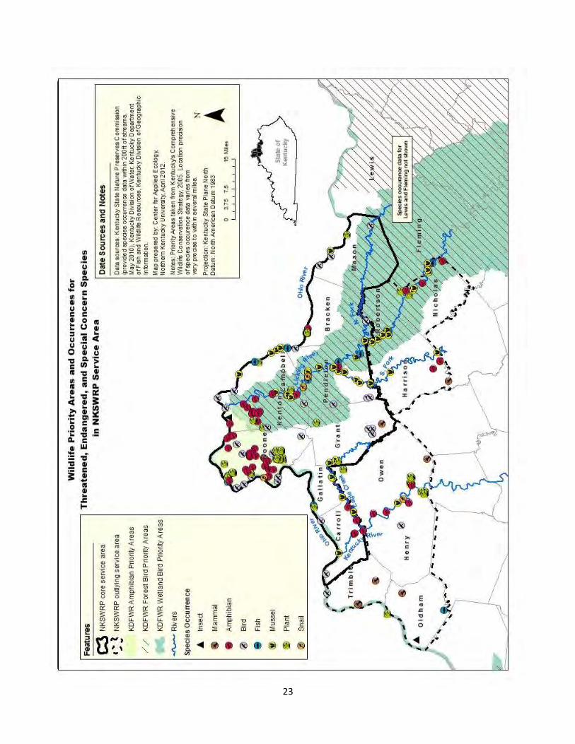
The State Nature Preserves Commission records of 191 state and/or federal rare plant and animal species are illustrated on an attached map and include (not limited to):
9
Fanshell, Pink Mucket, Sheepnose, and Salamander mussels
Northern Leopard Frog Redback Salamander (photo right) and Eastern
Hellbender (salamanders) Northern and Slender Madtom (fish) Running Buffalo Clover and Nodding
Rattlesnake-root (riparian zone plants) Black bear and eagle Indiana bat
Priority Conservation Areas designated by the KDFWR for the “purpose of focusing conservation efforts that benefit the largest number of species with the greatest conservation need” (Kentucky's Comprehensive Wildlife Conservation Strategy, 2005) are illustrated on an attached map and include:
Wetland Bird Priority Areas: Ohio River bottoms (west) and Licking River watershed Forest Bird Priority Area: Licking River watershed Amphibian Priority Area: portions of northern Boone and Kenton Counties C. FEDERALLY DESIGNATED THREATENED AND ENDANGERED SPECIES
US Fish and Wildlife Service maintains a list of known and potentially-occurring federally-designated threatened and endangered species by county. A summary list of T&E species for the NKSWRP counties (bold type) and surrounding Kentucky counties is provided as an attachment.
Federal T&E species known to occur in the NKSWRP counties include 8 species of mussels and one plant (Running buffalo clover). Indiana bat is not known to occur in the service area, but is listed as potentially occurring in all NKSWRP counties. USFWS T&E information can be viewed directly at: http://www.fws.gov/frankfort/EndangeredSpecies.html.
D. EXCEPTIONAL USE WATERS AND AQUATIC LIFE USE SUPPORT
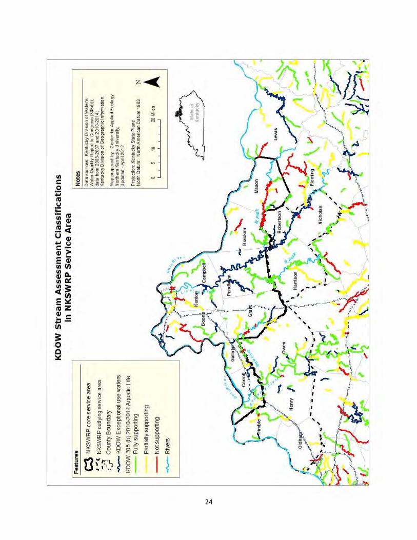
Exceptional Use Waters include streams designated by KDOW as reference reach waters and/or streams that exhibit “excellent” populations of fish or macroinvertebrates. Exceptional Use Waters (2009) and Aquatic Life Use Support designation (2003-2007 and 2010-2014), as determined by KDOW for northern Kentucky streams, are illustrated on an attached map. The streams deemed Exceptional Use Waters and the counties in which they are located are listed below:
Licking River main stem (multiple counties) Boone: Double Lick, Little South Fork, Garrison Creek, Second Creek Carroll: Indian Creek Gallatin: UT to Big Sugar Creek
10
Henry: Drennon Creek, Emily Run, Little Sixmile Creek, Sixmile Creek Kenton: Bowman Creek, Sawyer’s Fork Lewis: Kinniconick Creek Mason: UT to Shannon Creek Owen: Mill Creek, Severn Creek, UT to Cedar Creek Pendleton: Blanket Creek, Flour Creek, Grover’s Creek, South Fork Grassy Creek Robertson: West Creek Trimble: UT to Corn Creek
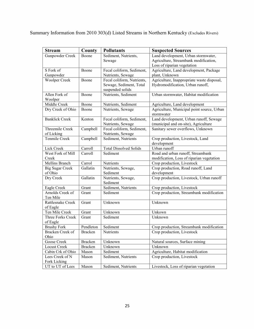
E. 2010 303(D) LIST OF IMPAIRED WATERS
Excluding rivers and those streams listed solely for pollution attributed to sewage, a total of 48 streams in the Service Area core counties are included in the 2010 303(d) List of Impaired Waters, compiled by KDOW. A summary table of impairments by stream is provided on an attached table. The summary calculations below exclude Lewis and Fleming counties. Among these 48 impaired streams, the most common pollutants identified by KDOW are, excluding sewage, in order of predominance:
Sediment (28 streams; 58%) Nutrients (27 streams; 56%) Fecal coliform from farm operations (3 streams; 6%).
Consistent with nation-wide trends, the KDOW-identified sources of these pollutants are, in order of predominance:
Urbanization (42 streams; 88%) o Land development (16 streams; 33%) o Stormwater runoff (13 streams; 27%) o Hydromodification (13 streams; 27%)
Agriculture (29 streams; 60%) Loss of riparian vegetation (4 streams; 8%)
The source of impairment for one stream was determined to be surface mining, four other streams were impaired by industrial/municipal discharges, and the source of impairment for eleven streams was determined to be “unknown”.
Note that most stream miles have not yet been assessed, and assessments typically do not include the lowest order, upper headwater streams that are priorities for stream mitigation. The total number and length of impaired streams is no doubt much more than currently documented. Nevertheless, the identified pollutants and sources are believed to be representative of the impairments for all streams in the region.

11
F. SD1 WATERSHED CHARACTERIZATION REPORTS
In addressing its consent decree with USEPA and KDOW, SD1 assessed the conditions of 16 watersheds (not HUC 8 sub-basins) that comprise Boone, Kenton, and Campbell Counties, and prepared Watershed Characterization Reports for each watershed. These reports address current and future land cover, stream conditions such as bank and bed erosion, water quality sampling data, etc. They provided the basis for the development of 5-Year Watershed Plans submitted to the agencies in June 2009 and to be updated every five years until 2025. The Plans were based upon a watershed approach to water quality attainment, emphasizing green solutions rather than only conventional “gray” (concrete) technologies. The primary focus of the consent order is fecal coliform (determined to be an issue “almost everywhere” in the SD1 service area); however, the reports also address sediment and other pollutants, hydromodification, and other impairments to some extent. Information on obtaining the watershed reports can be found at: sd1.org.
Map source: http://sd1.org/documents/Summary-2009_Final.pdf
G. LAND USE TRENDS
Positive trends in land use and development in northern Kentucky include:
Implementation of construction site BMPs (sediment and erosion control) Improving regulation of agricultural and urban stormwater runoff (quality and quantity) Emerging awareness of green engineering and infrastructure, riparian buffer and floodplain
protections, low-impact / conservation development, and other practices benefiting aquatic resources among local government, developers, and citizens
Idled land reforestation (albeit with high invasive/non-natives and low diversity) Voluntary land conservation among private, non-profit (e.g., local conservancies), government, and
government-supported (EQIP, WHIP, CRP, HIP) landowners Correction of failing sewer systems such as combined sewer overflows (CSOs) and sanitary sewer
overflows (SSOs) by SD1 (consent decree compliance deadline 2025) and reduction of straight pipe discharges in rural areas (e.g., 319 grants)
12
Improved waste management and refuse cleanup (e.g., Clean County Certification)
Negative or flat trends in land use and development in northern Kentucky include:
Increasing impervious surfaces and stormwater piping associated with continued development Resistance to zoning and subdivision regulation changes to facilitate conservation development
practices (e.g., curb and gutter drainage, minimum pavement width requirements) Development on land-slide prone, currently-forested hillsides Lack of maintenance or repair of prior stream hydromodifications: impoundment failure, culvert
plugging/outlet erosion, bank armor failure, bank erosion, channel incision, etc. Spread of invasive/non-native vegetation such as bush honeysuckle Slow implementation of agriculture water quality BMPs H. CHRONIC ISSUES
All of the causes of stream impairment described above—urban and agricultural runoff pollution, hydromodification, lack of riparian vegetation, and improper refuse disposal—are chronic stream issues in northern Kentucky. Among historic impairments, perhaps only industrial point sources and landfill leachate are no longer uncontrolled, systemic issues.
IV. GOALS AND OBJECTIVES
The goal of the NKSWRP is to locally fulfill the purpose of Section 404 of the Clean Water Act and the Compensatory Mitigation Rule, namely:
To restore and maintain the chemical, physical and biological integrity of the Nation’s waters, and To compensate for the loss of aquatic resource functions and services that result from permitted
impacts to streams and wetlands.
Practically speaking, the most commonly permitted impact to streams is the culvertization (loss) of headwater streams for land development. Mitigation projects will offset the permitted stream losses by restoring streams at project sites—addressing urban and agricultural runoff pollution, hydromodification, lack of riparian vegetation, and improper refuse disposal.
V. PRIORITIZATION STRATEGY
To the extent practicable, NKSWRP mitigation projects will be selected considering the following priorities:
In-kind mitigation. In general, stream impacts will be mitigated with stream projects, and wetland impacts will be mitigated with wetland projects. Furthermore, perennial and intermittent headwater streams will be prioritized, since these are the jurisdictional streams most commonly
13
impacted. Headwater streams are defined by KDOW as generally draining less than 5 square miles, and in northern Kentucky headwater streams are generally high gradient (rocky-bottom). In order to address a major regional stream impairment source—urban stormwater runoff—mitigation using “green” practices such as stormwater wetlands or biodetention may be appropriate, so long as it is not addressing regulatory requirements of other parties. Similarly, riparian wetlands are often integral to stream functions and services, such as groundwater/baseflow recharge, floodwater storage and energy dissipation, and habitat, and may be an appropriate component of a stream mitigation project. The Corps may approve mitigation using out-of-kind and/or non-jurisdictional waters on a case-by-case basis where it serves the aquatic resource needs of the watershed.
Addresses multiple functions and services: aquatic and wildlife habitat, floodwater storage and downstream flood protection, water energy dissipation, temperature moderation, pollutant removal, natural aesthetics, environmental education, etc.
Protects buffers, aquatic or semi-aquatic T&E species, and/or critical habitat. Located adjacent to or near previously approved ILF project, public natural lands,
environmental conservation lands, etc. Located within the same major river basin (i.e., Ohio, Licking, or Kentucky) where impacts
were generated. To the extent practicable, projects will be proportionately distributed to major river basins based upon impacts. Other considerations such as the size, quality, and timeliness of available project sites may override this criterion.
Addresses pollutants and/or sources identified in watershed or stream assessments and/or the 303(d) list, such as sediment or nutrients attributable to hydromodification, bank erosion, lack of riparian buffer, etc. Water quality issues which are too severe may eliminate project sites from consideration. Projects should directly reduce pollutants of concern, or other actions within the watershed should address identified water quality issues so that restored habitat may be utilized by organisms. Sewage related impairments, such as rural straight pipes and failing septic systems, or antiquated urban sanitary sewers, will not be directly mitigated.
Practicability of implementation: cost-effectiveness, constructability, self-sustainability, development trends, landscape position, habitat connectivity, etc. will be considered to maximize project benefits and the probability of long-term success. Candidate sites with multiple utility line or roadway easements will be scrutinized to ensure the existing or planned disturbance will not significantly compromise the mitigation site success.
Voluntary landowner participation. Preference will be given to projects with voluntary participation from either public or private landowners; however, purchase of conservation easements or land title may be necessary or desirable under certain circumstances (e.g., habitat for threatened or endangered aquatic or semi-aquatic species, mature riparian forest, adjoining public natural area, etc.).
Existing watershed plans (not necessarily USEPA Watershed Based Plan format or contents). The following watersheds have plans developed or under development:
o Upper Allen Fork (Boone County Engineer) o Banklick Creek (Banklick Creek Watershed Council; KDOW First Priority Watershed) o Gunpowder Creek (Boone County Conservation District) o Woolper Creek (Boone County Conservation District) o Lower Eagle Creek (Kentucky Watershed Management Framework 2001 Priority Watershed) o Ten Mile Creek (N. Ky Independent Health District; mostly focused on fecal coliform)
14
o 16 watersheds of the SD1 service area (see above)
Other plans may exist or be under development.
Complements regional conservation initiatives such as: o Local watershed planning initiatives (see above) o KDOW Licking River Basin Management Unit o USDA Mississippi River Basin Initiative Focus Area Watershed (Licking River) o SD1 Green Infrastructure Program and Watershed Community Council o Licking River Watershed Watch o Northern Kentucky Urban and Community Forestry Council
Risk to aviation. From the Compensatory Mitigation Rule preamble: “Locating compensatory
mitigation projects near airports is likely to attract wildlife species and pose hazards to aviation.
This does not mean that no compensatory mitigation projects can be located near any airport; it
means that compatibility with existing facilities must be considered.”
VI. PRESERVATION
From the Compensatory Mitigation Rule preamble: Preservation is particularly valuable for protecting
unique, rare, or difficult-to-replace aquatic resources, such as bogs, fens, and streams, and may be the
most appropriate form of compensatory mitigation for those resources.
According to USEPA, “existing, relatively intact ecosystems are the keystone for conserving biodiversity, and provide the biota and other natural materials needed for the recovery of impaired systems” (http://www.epa.gov/owow/wetlands/restore/principles.html). In addition to protection of Exceptional Use Waters, aquatic or semi-aquatic T&E species, and other priority natural or aquatic resources, preservation may also be appropriate as a means to preserve and restore streams and riparian vegetation in other urban and rural landscapes. Restoration and preservation of riparian buffers is currently being promoted by numerous land management entities such as SD1, Conservation Districts, NRCS, Boone County Planning, Northern Kentucky Area Planning, etc. to address issues of urban stormwater runoff quantity and quality, flooding, agricultural water quality, bank erosion, wildlife corridors, greenspace and livable communities, air pollution, and (recently) carbon sequestration. ILF projects consisting of 100% preservation or where preservation is the major emphasis of a project may be implemented if it meets the needs of the watershed, the resource is rare or difficult to replace, or for other reasons as approved by the Corps. Preservation may be used to provide mitigation when all the following criteria are met:
1. The resources to be preserved provide important physical, chemical, or biological functions for the watershed.
15
2. The resources to be preserved contribute significantly to the ecological sustainability of the watershed (to be determined quantitatively if practicable). [Interpreted to mean the resource
must be in high quality condition rather than impaired condition based upon functional
assessment.]
3. Preservation is determined to be appropriate and practicable.
4. The resources are under threat of destruction or adverse modifications.
5. The preserved site will be permanently protected through an appropriate site protection instrument (e.g., easement, title transfer to state resource agency or land trust).
VII. STAKEHOLDER INVOLVEMENT
An October 2010 draft of this CPF was submitted via email to over 100 individuals and organizations known to be involved in natural resources conservation and protection within the service area, many of whom have worked directly with the NKSWRP on past projects. In addition to being invited to review and comment on the CPF, stakeholders were invited to forward the invitation to other potentially interested parties, and to suggest candidate mitigation project opportunities. Additionally, anyone visiting the NKSWRP website (http://nkswrp.nku.edu) will see a link to view the CPF. Email solicitation of stakeholder input will be repeated approximately biannually. Stakeholder input will be incorporated into future updates to this CPF.
VIII. LONG-TERM PROTECTION AND MANAGEMENT
Mitigation project sites are to be provided long-term site protection to protect the site against future incompatible uses to the extent practicable. (In cases of public or private lands that inherently have a natural areas preservation function, such as state wildlife management areas and natural areas owned by conservation organizations, a project-specific site protection instrument may not be necessary.) The options for long-term site protection include conservation easement or deed restriction, transfer of title to a conservation organization or agency, or in certain circumstances, a management agreement. Prior to executing a conservation easement or deed restriction, the NKSWRP will conduct a title search. If it is determined that there is a mortgage on the property, the NKSWRP will attempt to subordinate the mortgagee’s interest to the conservation easement. The Corps will be apprised of the site protection mechanism in the Mitigation Project Plan.
Site protection instruments executed after the effective date of this Instrument will include a clause requiring the Corps to be notified 60 days prior to voiding or substantially modifying the instrument. The conservation easement holder (if applicable) and Corps shall also be notified 60 days prior to transfer of property ownership.

16
If efficacious to move the project forward in a timely manner, the landowner may sign a memorandum of agreement to execute the site protection instrument at a later date.
Each project budget will include a line item cost to be deposited into the Site Protection Account. This is to be a non-wasting account (endowment) used to perform long-term site protection tasks including, but not limited to, periodic site inspections, replacement of boundary posts, fencing, landowner or neighbor contacts, and legal assistance to ensure the provisions of conservation easements, deed restriction, and/or management agreements are enforced.
NKURF, as designated holder of all conservation easements obtained to date, has established a formal conservation easement monitoring and enforcement policy.
IX. EVALUATION AND REPORTING
Program Evaluation and Reporting is addressed in the NKSWRP Instrument, to which this CPF is an attachment.
17
FIGURES Impact and Project Sites
Major Watersheds
Level IV Ecoregions
Hydric and Partially Hydric Soils
Land Cover
Wildlife Priority Areas and Occurrences for Threatened, Endangered, and Special Concern Species
KDOW Stream Assessment Classifications
TABLES
Summary Information from 2010 303(d) Listed Streams in Northern Kentucky
T&E Species Potentially Occurring is Service Area

18
19
20

21

22
23
24
25
Summary Information from 2010 303(d) Listed Streams in Northern Kentucky (Excludes Rivers)
Stream County Pollutants Suspected Sources Gunpowder Creek Boone Sediment, Nutrients,
Sewage Land development, Urban stormwater, Agriculture, Streambank modification, Loss of riparian vegetation
S Fork of Gunpowder
Boone Fecal coliform, Sediment, Nutrients, Sewage
Agriculture, Land development, Package plant, Unknown
Woolper Creek Boone Fecal coliform, Nutrients, Sewage, Sediment, Total suspended solids
Agriculture, Inappropriate waste disposal, Hydromodification, Urban runoff,
Allen Fork of Woolper
Boone Nutrients, Sediment Urban stormwater, Habitat modification
Middle Creek Boone Nutrients, Sediment Agriculture, Land development Dry Creek of Ohio Boone Nutrients, Sewage Agriculture, Municipal point source, Urban
stormwater Banklick Creek Kenton Fecal coliform, Sediment,
Nutrients, Sewage Land development, Urban runoff, Sewage (municipal and on-site), Agriculture
Threemile Creek of Licking
Campbell Fecal coliform, Sediment, Nutrients, Sewage
Sanitary sewer overflows, Unknown
Tenmile Creek Campbell Sediment, Nutrients Crop production, Livestock, Land development
Lick Creek Carroll Total Dissolved Solids Urban runoff West Fork of Mill Creek
Carroll Sediment Road and urban runoff, Streambank modification, Loss of riparian vegetation
Mellins Branch Carrol Nutrients Crop production, Livestock Big Sugar Creek of Ohio
Gallatin Nutrients, Sewage, Sediment
Crop production, Road runoff, Land development
Dry Creek Gallatin Nutrients, Sewage, Sediment
Crop production, Livestock, Urban runoff
Eagle Creek Grant Sediment, Nutrients Crop production, Livestock Arnolds Creek of Ten Mile
Grant Sediment Crop production, Streambank modification
Rattlesnake Creek of Eagle
Grant Unknown Unknown
Ten Mile Creek Grant Unknown Unkown Three Forks Creek of Eagle
Grant Sediment Unknown
Brushy Fork Pendleton Sediment Crop production, Streambank modification Bracken Creek of Ohio
Bracken Nutrients Crop production, Livestock
Goose Creek Bracken Unknown Natural sources, Surface mining Locust Creek Bracken Unknown Unknown Cabin Crk of Ohio Mason Sediment Agriculture, Habitat modification Lees Creek of N Fork Licking
Mason Sediment, Nutrients Crop production, Livestock
UT to UT of Lees Mason Sediment, Nutrients Livestock, Loss of riparian vegetation
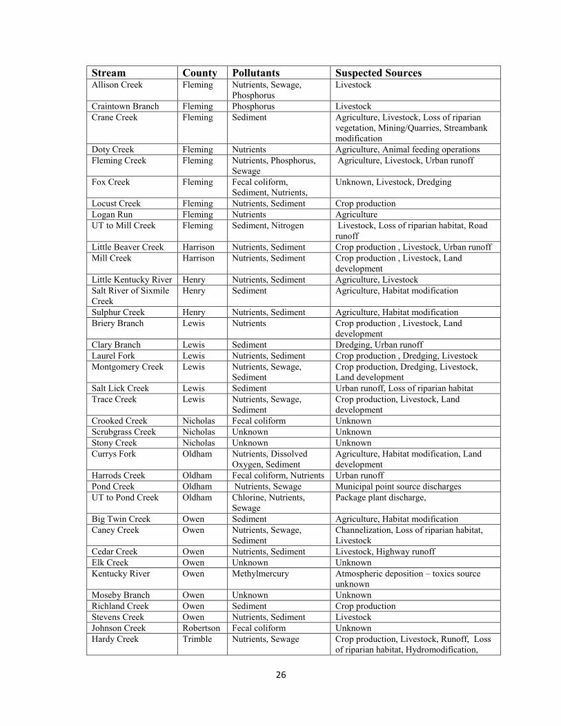
26
Stream County Pollutants Suspected Sources Allison Creek Fleming Nutrients, Sewage,
Phosphorus Livestock
Craintown Branch Fleming Phosphorus Livestock Crane Creek Fleming Sediment Agriculture, Livestock, Loss of riparian
vegetation, Mining/Quarries, Streambank modification
Doty Creek Fleming Nutrients Agriculture, Animal feeding operations Fleming Creek Fleming Nutrients, Phosphorus,
Sewage Agriculture, Livestock, Urban runoff
Fox Creek Fleming Fecal coliform, Sediment, Nutrients,
Unknown, Livestock, Dredging
Locust Creek Fleming Nutrients, Sediment Crop production Logan Run Fleming Nutrients Agriculture UT to Mill Creek Fleming Sediment, Nitrogen Livestock, Loss of riparian habitat, Road
runoff Little Beaver Creek Harrison Nutrients, Sediment Crop production , Livestock, Urban runoff Mill Creek Harrison Nutrients, Sediment Crop production , Livestock, Land
development Little Kentucky River Henry Nutrients, Sediment Agriculture, Livestock Salt River of Sixmile Creek
Henry Sediment Agriculture, Habitat modification
Sulphur Creek Henry Nutrients, Sediment Agriculture, Habitat modification Briery Branch Lewis Nutrients Crop production , Livestock, Land
development Clary Branch Lewis Sediment Dredging, Urban runoff Laurel Fork Lewis Nutrients, Sediment Crop production , Dredging, Livestock Montgomery Creek Lewis Nutrients, Sewage,
Sediment Crop production, Dredging, Livestock, Land development
Salt Lick Creek Lewis Sediment Urban runoff, Loss of riparian habitat Trace Creek Lewis Nutrients, Sewage,
Sediment Crop production, Livestock, Land development
Crooked Creek Nicholas Fecal coliform Unknown Scrubgrass Creek Nicholas Unknown Unknown Stony Creek Nicholas Unknown Unknown Currys Fork Oldham Nutrients, Dissolved
Oxygen, Sediment Agriculture, Habitat modification, Land development
Harrods Creek Oldham Fecal coliform, Nutrients Urban runoff Pond Creek Oldham Nutrients, Sewage Municipal point source discharges UT to Pond Creek Oldham Chlorine, Nutrients,
Sewage Package plant discharge,
Big Twin Creek Owen Sediment Agriculture, Habitat modification Caney Creek Owen Nutrients, Sewage,
Sediment Channelization, Loss of riparian habitat, Livestock
Cedar Creek Owen Nutrients, Sediment Livestock, Highway runoff Elk Creek Owen Unknown Unknown Kentucky River Owen Methylmercury Atmospheric deposition – toxics source
unknown Moseby Branch Owen Unknown Unknown Richland Creek Owen Sediment Crop production Stevens Creek Owen Nutrients, Sediment Livestock Johnson Creek Robertson Fecal coliform Unknown Hardy Creek Trimble Nutrients, Sewage Crop production, Livestock, Runoff, Loss
of riparian habitat, Hydromodification,
27
Data Source: http://www.water.ky.gov/NR/rdonlyres/58E97683-C9B7-4F9F-BA87-93671E6A02D9/0/2008volume2final.pdf
Notes Regarding Summary Information:
Sediment = Sediment/Siltation or Turbidity Nutrients = Nutrients/Eutrophication Sewage = Sewage/Organic Enrichment Livestock – Grazing, Feedlots, Dairies Bold – TMDL to be released 2009 Italics – TMDL being developed No TMDL targets have been developed for Nutrients and Sewage Strikethrough – Omits streams listed only for bacteria (fecal coliform).

28
MA
MM
AL
SM
US
SE
LS
PL
AN
TS
Myo
tis
soda
lis
Myo
tis
gris
esce
ns
Ple
urob
ema
clav
a
Cyp
roge
nia
steg
aria
Ple
thob
asus
coop
eria
nus
Lam
psili
s
abru
pta
Ple
urob
ema
plen
m
Epi
obla
sma
toru
losa
rang
iana
Ob
ovar
ia
retu
sa
Epi
obla
sma
o. o
bliq
uata
Trif
oliu
m
stol
onife
rum
Ara
bis
pers
tella
ta
Sol
idag
o
shor
tii
Ara
bis
pers
tella
nta
Indi
ana
bat
gray
bat
club
shel
lfa
nshe
llor
ange
foot
pim
pleb
ack
pink
muc
ket
roug
h pi
gtoe
nort
hern
riffle
shel
l
ring
pink
purp
le
cats
paw
pear
lym
usse
l
runn
ing
buffa
lo c
love
r
Bra
un's
rock
cres
s
Sho
rt's
gold
enro
d
Bra
un's
rock
cres
s
End
ange
red
End
ange
red
End
ange
red
End
ange
red
End
ange
red
End
ange
red
End
ange
red
End
ange
red
End
ange
red
End
ange
red
End
ange
red
End
ange
red
End
ange
red
End
ange
red
Bo
on
e
Pot
entia
lP
oten
tial
Pot
entia
lP
oten
tial
Kn
ow
nP
oten
tial
Pot
entia
lK
no
wn
Bra
cke
nP
oten
tial
Kn
ow
nK
no
wn
Pot
entia
lP
oten
tial
Pot
entia
lP
oten
tial
Pot
entia
lP
oten
tial
Ca
mp
be
llP
oten
tial
Kn
ow
nK
no
wn
Kn
ow
nK
no
wn
Kn
ow
nP
oten
tial
Pot
entia
lP
oten
tial
Ca
rro
llP
oten
tial
Pot
entia
lP
oten
tial
Kn
ow
nK
no
wn
Pot
entia
lP
oten
tial
Pot
entia
l
Ga
lla
tin
Pot
entia
lK
no
wn
Pot
entia
lP
oten
tial
Pot
entia
lP
oten
tial
Pot
entia
lP
oten
tial
Gra
nt
Pot
entia
lP
oten
tial
Pot
entia
l
Ke
nto
nP
oten
tial
Kn
ow
nK
no
wn
Kn
ow
nK
no
wn
Kn
ow
nK
no
wn
Kn
ow
nK
no
wn
Kn
ow
n
Ma
son
K
no
wn
Kn
ow
nK
now
nP
oten
tial
Pot
entia
lP
oten
tial
Pot
entia
lP
oten
tial
Pe
nd
leto
nP
oten
tial
Kn
ow
nK
no
wn
Pot
entia
lK
no
wn
Kn
ow
nK
no
wn
Pot
entia
lP
oten
tial
Har
rison
Pot
entia
lK
no
wn
Kn
ow
nP
oten
tial
Pot
entia
lP
oten
tial
Kn
ow
n
Hen
ryP
oten
tial
Kn
ow
nP
oten
tial
Kn
ow
nK
no
wn
Lew
isP
oten
tial
Pot
entia
lK
no
wn
Kn
ow
nK
no
wn
Kn
ow
nK
no
wn
Kn
ow
n
Nic
hola
sP
oten
tial
Pot
entia
lK
no
wn
Pot
entia
lP
oten
tial
Pot
entia
lP
oten
tial
Kn
ow
n
Old
ham
P
oten
tial
Kn
ow
nP
oten
tial
Pot
entia
lP
oten
tial
Pot
entia
lP
oten
tial
Pot
entia
lP
oten
tial
Ow
en
Pot
entia
lK
no
wn
Kn
ow
nP
oten
tial
Kn
ow
n
Rob
erts
onP
oten
tial
Kn
ow
nK
no
wn
Pot
entia
lP
oten
tial
Pot
entia
lP
oten
tial
Kn
ow
n
Trim
ble
Kn
ow
nP
oten
tial
Pot
entia
lK
no
wn
Pot
entia
lP
oten
tial
Pot
entia
lP
oten
tial
sour
ce:
htt
p://
ww
w.fw
s.go
v/fra
nkfo
rt/E
ndan
gere
dSpe
cies
.htm
l
Jan-
12
Appendix B: NKSWRP 2016 Annual Report (16 pages)
NKSWRP Annual Report Page 1
Northern Kentucky
Stream and Wetland Restoration Program
2016 Annual Report
February 2017
Background / Purpose
The Northern Kentucky Stream and Wetland Restoration Program (NKSWRP) is an in-lieu-fee
program providing compensatory mitigation for the loss of stream and wetland resources in
northern Kentucky due to land development. The program was established in 1999, and operates
under an Agreement among the Louisville District of the U.S. Army Corps of Engineers (Corps),
the Northern Kentucky University Center for Environmental Restoration (CER), and the Northern
Kentucky University Research Foundation (NKURF).
Funding for the program is generated from the sale of mitigation credits to entities that impact (fill)
streams or wetlands for land development under permit from the Corps. NKURF receives in-lieu-
fee (ILF) payments from permittees, and distributes funds to the CER to operate the program and
implement mitigation projects. The CER identifies stream and wetland restoration and
preservation opportunities, then undertakes projects to protect, enhance, restore, and monitor
projects. Project sites, plans, and compliance reports are subject to approval by the Corps, in
consultation with the Interagency Review Team (IRT).
The Compensation Planning Framework, which describes how the CER selects and prioritizes
mitigation projects, may be viewed at environmentalrestoration.nku.edu/.
In accordance with the federal rule entitled Compensatory Mitigation for Losses of Aquatic
Resources (April 2008), the CER, NKURF, and the Corps executed a new program Agreement to
replace the prior Agreement. Mitigation implemented under the original Agreement (1999) is
referred to as Phase 1; no additional impacts are being mitigated through this program. Mitigation
implemented after the effective date of the new Agreement (April 2012) is referred to as Phase 2.
NKSWRP Annual Report Page 2
Record of ILF Payments
A record of ILF payments is provided in Table 1 (Phase 1) and Table 2 (Phase 2). One payment
collected from Kentucky Utilities (KU) under the Phase 1 program is managed and accounted
separately due to its unusually large scale. Additionally, two Phase 1 payments were a pass-
through to USFWS and a refunded payment. Lastly, Phase 1 funds not obligated to approved
projects at the time of Phase 2 initiation were transferred to the Phase 2 Program. Based upon
these accounting adjustments, total adjusted ILF deposits to each program through December 2016
are as follows:
Phase 1: $12,976,207
Phase 2: $8,549,356
Kentucky Utilities: $13,290,792
TOTAL $34,816,355
Figure 1 illustrates 69 Corps-permitted development sites for which ILF payments were received
through December 2016:
Phase 1: 50 impact sites, including Kentucky Utilities
Phase 2: 19 impact sites
Phase 2 Debit/Credit Ledger
Table 2 provides the debit/credit ledger for the Phase 2 program, which documents Phase 2 ILF
deposits and debits from the program’s Advance Credits. Approximately 26,000 stream credits
out of 60,000 Advance Credits have been sold through December 2016 (43%).
No wetlands credits have been sold from the ten advance wetlands credits are available for sale
from the NKSWRP. Wetlands mitigation credits are available to the development community
from the Northern Kentucky Mitigation Bank.
Summary of Mitigation Projects
Figure 2 illustrates the locations of 28 Corps/IRT approved mitigation projects:
Phase 1: 20 mitigation projects
KU: 5 mitigation projects
Phase 2: 3 mitigation projects
NKSWRP Annual Report Page 3
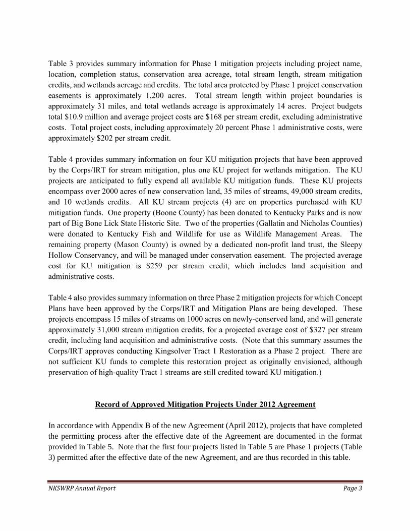
Table 3 provides summary information for Phase 1 mitigation projects including project name,
location, completion status, conservation area acreage, total stream length, stream mitigation
credits, and wetlands acreage and credits. The total area protected by Phase 1 project conservation
easements is approximately 1,200 acres. Total stream length within project boundaries is
approximately 31 miles, and total wetlands acreage is approximately 14 acres. Project budgets
total $10.9 million and average project costs are $168 per stream credit, excluding administrative
costs. Total project costs, including approximately 20 percent Phase 1 administrative costs, were
approximately $202 per stream credit.
Table 4 provides summary information on four KU mitigation projects that have been approved
by the Corps/IRT for stream mitigation, plus one KU project for wetlands mitigation. The KU
projects are anticipated to fully expend all available KU mitigation funds. These KU projects
encompass over 2000 acres of new conservation land, 35 miles of streams, 49,000 stream credits,
and 10 wetlands credits. All KU stream projects (4) are on properties purchased with KU
mitigation funds. One property (Boone County) has been donated to Kentucky Parks and is now
part of Big Bone Lick State Historic Site. Two of the properties (Gallatin and Nicholas Counties)
were donated to Kentucky Fish and Wildlife for use as Wildlife Management Areas. The
remaining property (Mason County) is owned by a dedicated non-profit land trust, the Sleepy
Hollow Conservancy, and will be managed under conservation easement. The projected average
cost for KU mitigation is $259 per stream credit, which includes land acquisition and
administrative costs.
Table 4 also provides summary information on three Phase 2 mitigation projects for which Concept
Plans have been approved by the Corps/IRT and Mitigation Plans are being developed. These
projects encompass 15 miles of streams on 1000 acres on newly-conserved land, and will generate
approximately 31,000 stream mitigation credits, for a projected average cost of $327 per stream
credit, including land acquisition and administrative costs. (Note that this summary assumes the
Corps/IRT approves conducting Kingsolver Tract 1 Restoration as a Phase 2 project. There are
not sufficient KU funds to complete this restoration project as originally envisioned, although
preservation of high-quality Tract 1 streams are still credited toward KU mitigation.)
Record of Approved Mitigation Projects Under 2012 Agreement
In accordance with Appendix B of the new Agreement (April 2012), projects that have completed
the permitting process after the effective date of the Agreement are documented in the format
provided in Table 5. Note that the first four projects listed in Table 5 are Phase 1 projects (Table
3) permitted after the effective date of the new Agreement, and are thus recorded in this table.
NKSWRP Annual Report Page 4
Mitigation Timeline
As of December 2015, all 20 Phase 1 mitigation projects have been constructed. All projects were
completed as planned with only minor modifications, except a portion of the Latonia-Banklick
project was not completed due to the landowner’s inability to control trespass ATV usage. Eight
projects are in the maintenance and monitoring phase. All others have been released from
monitoring, having demonstrated project performance/success criteria.
Relative to the five approved Kentucky Utilities mitigation projects (Table 2), the Corps has
determined physical restoration should be initiated by the end of the third full growing season after
approval of project Concept Plans. All four stream mitigation projects were approved in 2013;
therefore, the target restoration start date for KU stream mitigation projects was before October
31, 2016. The individual KU stream mitigation projects have each met the physical restoration
timelines as follows:
Stephens Creek: Permits issued and stream restoration initiated Summer 2016
Big Bone Phase 3: Permits issued and upland & stream restoration initiated Summer 2016
Sleepy Hollow: Upland work initiated Summer 2015 (watershed restoration, refuse and
1000+ tires removed, and emergency dam repair)
Kingsolver Tract 1: Upland work initiated Summer 2015 (refuse and 100+ tires removed).
Stream restoration to be proposed under Phase 2 program due to KU budget constraints.
Relative to the KU wetlands mitigation project, the St Annes project Concept Plan was approved
in April 2016. Pre-restoration hydrology monitoring is underway, and physical restoration will
commence prior to April 2019 in accordance with the timeline.
Relative to Phase 2 mitigation, the Agreement (Section III.H.) stipulates physical/ecological
improvements should begin by the end of the third full growing season after credit sales, if
sufficient funds are available. For simplicity, credit sales (Table 2) are deemed to have occurred
on December 31 of the year of sale. The following is a summary of physical restoration timelines:
Year of credit sale Credits sold Restoration start deadline
2012 2298 10/31/2015
2013 6614 10/31/2016
2014 6083 10/31/2017
2015 4821 10/31/2018
2016 5982 10/31/2019
NKSWRP Annual Report Page 5
Physical restoration at Darlington Farms (2,290 credits +/-) was initiated in the summer of 2015
(invasive species removal) thus essentially fulfilling the mitigation timeline for Year 2012 credit
sales. Additionally, stormwater basin dam removal was completed in April 2016 after Sanitation
District 1 approval.
Physical restoration at Sleepy Hollow Tracts 2 & 3 (7,562 credits +/-) was initiated in the summer
of 2015 (upland watershed restoration) thus fulfilling the mitigation timeline for Year 2013 credit
sales.
Physical restoration of Kingsolver Tract 2 (> 8,000 credits) is projected to be initiated in Spring
2018. Therefore we anticipate being approximately 6 months late meeting the Year 2014 credit
sales timeline. The restoration of both Tract 1 and 2 under Phase 2 (> 21,000 credits) will satisfy
the mitigation credits and timeline for 2014 through 2016 credit sales.
Fund Report
NKURF prepares an annual Fund Report documenting program receipts and expenses, account
balances, and interest income through the end of each fiscal year. The attached Report documents
that total funds available at the end of June 2016 were approximately $12 million in seven program
accounts established in accordance with the Agreement: Program Administration, Phase 1
Projects, Phase 2 Projects, Kentucky Utilities Projects, Site Protection (endowment), Site
Protection Income (for conservation easement management expenses), and Program Contingency.
Audit Report
The NKU Office of Internal Audit performs an annual audit of the Fund to ensure proper
accounting of revenues (ILF deposits and interest), program and project expenses, bank statements,
investments, etc. A copy of the audit summary memo for FY 2016 is attached, and documents that
no exceptions from generally accepted accounting practices were identified.
Credit Pricing
In accordance with the Agreement, credit pricing is based upon full cost accounting for program
operation and project expenses, including land acquisition and administration. The current stream
mitigation credit price is $470 per Adjusted Mitigation Unit. This price is based upon the estimated
restoration cost for a potential Phase 2 project under negotiation with the landowner, including
land acquisition, monitoring, contingency, and administrative costs.

NKSWRP Annual Report Page 6
Stream credit pricing will be adjusted periodically as actual project costs/estimates dictate.
Wetlands credits are not currently for sale by the NKSWRP, since ample wetlands credits are
available from Northern Kentucky Mitigation Bank.
Program Contingency
The NKSWRP seeks to maintain a minimum contingency fund in the amount of 10 percent of the
estimated project costs for outstanding Phase 1 and KU mitigation, and 15 percent of estimated
project costs for Phase 2. As documented in Table 2, the target minimum contingency fund is
approximately $1M. The current balance of the Program Contingency Fund is approximately $2.1
million (Fund Report), which is well above the target minimum.
In accordance with the Agreement, the NKSRP may utilize excess Program Contingency funds to
construct a new office and shop facility from which to more efficiently and effectively operate the
NKSRP.
Program Adaptive Management
The following changes were implemented to the NKSWRP in 2016:
An Advisory Committee was formed from members of the regional land development and
economic development communities, county judge executives (Boone, Kenton,
Campbell), local conservancies, watershed groups, and Sanitation District 1. The purpose
of the Committee is to keep stakeholders informed about the program and about
mitigation, and to inform the NKSWRP of potential mitigation projects that complement
their conservation and other efforts. The Committee is chaired by a judge executive, and
meets approximately quarterly. Of note, in January 2017, the Committee partnered with
the Kentucky Division of Compliance Assistance to host a “Floodplains, Stream and
Wetlands Compliance Workshop” on the NKU campus.
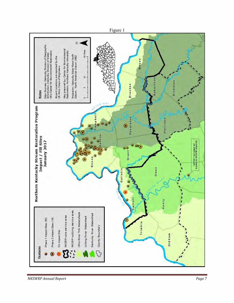
NKSWRP Annual Report Page 7
Figure 1
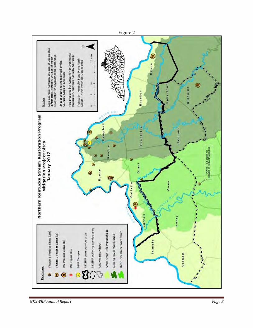
NKSWRP Annual Report Page 8
Figure 2
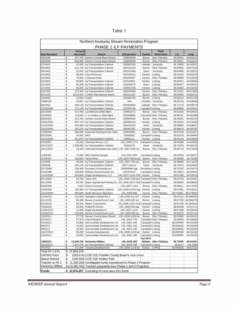
NKSWRP Annual Report Page 9
Table 1
Date Received
Amount
Received Source COE permit # County
Major
Watershed Lat Long
09/22/99 327,750$ Kenton County Airport Board 199900699 Boone Ohio Tributary 39.05091 -84.6613203/02/00 646,800$ Kenton County Airport Board 199900699 Boone Ohio Tributary 39.05091 -84.6613207/24/02 32,000$ Ky Transportation Cabinet 200000780 Gallatin Kentucky 38.70839 -84.9094709/19/02 211,755$ Ky Transportation Cabinet 200101229 Boone Ohio Tributary 38.94691 -84.6762610/14/02 22,200$ Ky Transportation Cabinet 200101568 Grant Kentucky 38.64696 -84.5832110/14/02 35,000$ City of Elsmere 200100512 Kenton Licking 39.01030 -84.6023512/10/02 70,000$ Corporex Parks 200200927 Kenton Ohio Tributary 39.05899 -84.6261812/13/02 99,800$ Ky Transportation Cabinet 200100501 Kenton Licking 38.99341 -84.5859912/13/02 95,200$ Ky Transportation Cabinet 200200679 Grant Licking 38.68327 -84.5802412/13/02 95,000$ Ky Transportation Cabinet 200001036 Kenton Licking 38.94930 -84.5933501/07/03 175,450$ Ky Transportation Cabinet 200200908 Kenton Ohio Tributary 39.01361 -84.5788504/11/03 3,016,000$ Cin/NK International Airport 200101187 Boone Ohio Tributary 39.05096 -84.661311/5/2004 19,000$ FedEx 200300748 Boone Licking 38.95414 -84.617037/28/2004 32,061$ Ky Transportation Cabinet N/A Franklin Kentucky 38.28746 -84.846488/6/2004 626,130$ Ky Transportation Cabinet 200300653 Gallatin Ohio Tributary 38.71270 -84.9487312/10/2004 175,140$ Ky Transportation Cabinet 200300766 Campbell Licking 38.86869 -84.394512/21/2005 414,750$ LandAmerica (Wal-Mart) 199901671 Boone Ohio Tributary 39.01049 -84.649323/15/2005 114,000$ J. A. Fielden co (Wal-Mart) 200300865 Campbell Ohio Tributary 38.98791 -84.404868/30/2005 221,700$ Kenton County Airport Board 199900699 Boone Ohio Tributary 39.05091 -84.6613210/31/2005 997,740$ Ky Transportation Cabinet 200300154 Kenton Licking 38.92544 -84.5440011/21/2005 194,469$ Ky Transportation Cabinet 200401022 Grant Kentucky 38.65806 -84.5868711/22/2005 242,220$ Ky Transportation Cabinet 200401357 Kenton Licking 38.99079 -84.587871/18/2006 506,280$ Industrial Developments International Inc.200500081 Boone Ohio Tributary 38.87329 -84.618079/22/2006 45,000$ NKU 20060001 Campbell Licking 39.03278 -84.4586410/12/2006 341,670$ Ky Transportation Cabinet 20050111 Kenton Licking 39.03143 -84.526084/16/2007 53,160$ Overlook-Reece, LLC LRL-2006-1774 Campbell Licking 39.06388 -84.4548310/11/2007 2,308,860$ Ky Transportation Cabinet 20061578 Grant Kentucky 38.71978 -84.6047910/11/2007 23,040$ Industrial Developments International Inc.LRL-2007-528-ncc Boone Ohio Tributary 39.06770 -84.70008
11/8/2007 75,840$ NKU Parking Garage LRL-2007-609 Campbell Licking 39.03259 -84.4607111/5/2007 108,000$ Terra Firma LRL-2007-00134-pjl Boone Ohio Tributary 39.06608 -84.702891/3/2008 45,000$ Ky Transportation Cabinet LRL-2007-794-jea Boone Ohio Tributary 39.09606 -84.716191/8/2008 105,120$ Ky Transportation Cabinet 2007-104ncc Grant Kentucky 38.74074 -84.606542/27/2008 236,400$ Rumpke of Kentucky, Inc 200600464-pgj Pendelton Licking 38.73155 -84.404734/14/2008 140,000$ Kilbane Environmental, Inc. 200101514 Campbell Licking 39.10031 -84.4869211/10/2008 204,600$ Eagle Development, LLC LRL-2007-1210-THE Kenton Licking 38.97288 -84.592169/11/2009 23,760$ Trans-Ash LRL-2006-1762-jea Campbell Ohio Tributary 39.03729 -84.404079/11/2009 63,780$ Eaton Asphalt and Paving Co, IncLRL-2006-1337-mdhCampbell Licking 38.89600 -84.386009/28/2009 1,623$ Drees Company LRL-2007-1153 Boone Ohio Tributary 39.09611 -84.7442510/5/2009 162,360$ KY Transportation Cabinet LRL-2004-01357-pgj Kenton Licking 38.97281 -84.4281112/14/2009 283,600$ North American Stainless LRL-2009-858 Carroll Ohio Tributary 38.719091 85.0739051/13/2010 121,500$ Sanitation District No 1 LRL-2009-41-LET Kenton Licking 38.97213 -84.5560303/11/2010 96,480$ Boone County Fiscal Court LRL-2005-597-pjl Boone Licking 38.97793 -84.5964706/10/2010 65,100$ Maxim Craneworks LRL-2006-1337-mdhCampbell Licking 38.87139 -84.3955507/19/2010 33,315$ Potterhill Homes LRL-2005-930-pgj Kenton Licking 38.95408 -84.5171112/20/2010 11,000$ Eagle Development LRL-2007-1210 Kenton Licking 38.97288 -84.5921612/20/2010 230,640$ Boone County Fiscal Court LRL-2009-805-pjl Boone Ohio Tributary 39.01978 -84.657101/16/2011 27,720$ Kenton County Airport Board LRL-2009-1033-let Boone Ohio Tributary 39.02686 -84.654313/10/2011 57,375$ City of Newport LRL-2007-778 Campbell Ohio Tributary 39.09460 -84.468404/15/2011 10,000$ Summerlake Development, Inc LRL-2001-100 Campbell Licking 38.926945 -84.391956/6/2011 10,000$ Summerlake Development, Inc LRL-2001-100 Campbell Licking 38.926945 -84.391959/8/2011 10,000$ Summerlake Development, Inc LRL-2001-100 Campbell Licking 38.926945 -84.3919510/27/2011 59,280$ Tuscany Development LRL-2008-1119-let Kenton Licking 39.005539 -84.5243312/2/2011 10,000$ Summerlake Development, Inc LRL-2001-100 Campbell Licking 38.926945 -84.39195
12/8/2011 13,290,792$ Kentucky Utilities LRL-2009-358
Carroll &
Gallatin Ohio Tributary 38.72966 -85.00281
12/19/2011 1,037,076$ Ky Transportation Cabinet LRL-2003-766 Campbell Licking 38.8477 -84.37863/1/2012 171,840$ Tuscany Development LRL-2008-1119-let Kenton Licking 39.005539 -84.52433
Total Ph 1 ILFs 27,834,376$ USFWS Pass (203,674)$ COE 015; Franklin County Braun's rock cressAirport Refund (155,500)$ COE 018; Walton ParkTransfer to Ph 2 (1,208,203)$ Unobligated funds transitioned to Phase 2 ProgramKentucky Utilities (13,290,792)$ Tracked separately from Phase 1 and 2 ProgramsTotal Ph 1
Funds 12,976,207$ Excluding KU and pass-thru funds
Northern Kentucky Stream Restoration ProgramPHASE 1 ILF PAYMENTS

NKSWRP Annual Report Page 10
Table 2
STREAMS WETLANDS
Advance Credits 60,000 Advance Credits 10.0 Credits Sold 25,798 Credits Sold 0.0 Released Credits Released CreditsReserve Released Credits Reserve Released CreditsAdvance Stream AMU Balance 34,202 Advance Wetlands AMU Balance 10.0
Permittee Corps IDDate Rec'd Latitude Longitude County
Major Watershe
d
Stream Credits
Sold $/AMU
Wetlands
Credits $/AMUMitigation Fee
$Note
s
Unobligated Ph 1 funds (1st) LRL-2008-1172 5/1/2012 n/a n/a n/a n/a 1,149 215$ n/a n/a 246,961.06$ (1)
Hemmer Airpark Int'l II LRL-2012-255 8/8/2012 39.0751 (84.6705) Boone Ohio R 221 215$ n/a n/a 47,520.00$ (1)
KYTC Ky-36 bridge LRL-2012-205 9/26/2012 38.7170 (85.2536) Carroll Ohio R 551 215$ n/a n/a 118,357.50$ (1)
Triple Crown LRL-2012-286 10/10/2012 38.9120 (84.6531) Boone Ohio R 314 215$ n/a n/a 67,524.00$ (1)
Rumpke Landfill Exp LRL-2006-464 10/10/2012 38.7330 (84.4054) Pendleton Licking R 63 215$ n/a n/a 13,545.00$
KYTC Ky-237 LRL-2012-254 1/8/2013 39.0210 (84.7013) Boone Ohio R 965 215$ n/a n/a 207,432.00$
Tuscany Development LRL-2008-1119 3/8/2013 39.0055 (84.5243) Kenton Licking R 272 240$ n/a n/a 65,280.00$ (1)
IDI Park South LRL-2005-81-pjl 8/16/2013 38.9025 (84.6216) Boone Ohio R 1,372 240$ n/a n/a 329,280.00$
Unobligated Ph 1 funds (2nd) LRL-2008-1172 10/11/2013 n/a n/a n/a n/a 4,005 240$ n/a n/a 961,242.42$ (1)
Ark Encounter, LLC LRL-2013-680-mdh 8/1/2014 38.6260 (84.5929) Grant Kentucky R 3,883 296$ n/a n/a 1,149,249.60$
Anchor Properties, Inc LRL-2013-975-mck 9/26/2014 38.9887 (84.6464) Boone Ohio R 2,200 296$ n/a n/a 651,200.00$
Schottenstein Real Est Group LRL-2014-631-pjl 2/23/2015 39.0061 (84.6623) Boone Ohio R 72 296$ n/a n/a 21,312.00$
Kenton County Airport Board LRL-2014-967-mck 6/12/2015 39.0455 (84.6376) Boone Ohio R 1,818 350$ n/a n/a 636,300.00$
Kenton County Airport Board LRL-2014-603-mck 6/22/2015 39.0368 (84.6590) Boone Ohio R 1,291 350$ n/a n/a 451,850.00$
Chavez Properties (FastPark) LRL-2014-346 9/28/2015 39.0730 (84.6586) Boone Ohio R 1,497 470$ n/a n/a 703,590.00$
Seven Hills Church LRL-2014-197-pgj 9/29/2015 39.0149 (84.6253) Boone Ohio R 143 470$ n/a n/a 67,210.00$
Lyons Magnus East Inc LRL-2014-305-mck 2/18/2016 38.9188 (84.6160) Boone Ohio R 871 470$ n/a n/a 409,370.00$
KYTC Johns Hill to Threemile LRL-2009-1251-jea 3/21/2016 39.0341 (84.4691) Campbell Licking R 638 470$ n/a n/a 299,860.00$
FedEx N KY Hub Facility LRL-2015-785-mdh 7/22/2016 38.9425 (84.6114) Kenton Licking R 1,592 470$ n/a n/a 748,202.40$
Al Neyer LRL-2016-00065-teh 9/28/2016 39.079172 -84.722235 Boone Ohio R 1,234 470$ n/a n/a 579,980.00$
Kenton County Airport Board LRL-2016-138-mdh 10/28/2016 39.01778 -84.64667 Boone Ohio R 1,647 470$ n/a n/a 774,090.00$
TOTAL PHASE 2 25,798 8,549,355.98$ Notes:
(1) - Total mitigation fee set by Corps under MOU LRL-2008-1172; converted to Ph 2 debits based upon then-current Ph 2 $/AMU.
Project Acct Balance Reserve %Phase 1 Contingency: 93,000$ X 10% =
KU Contingency: 3,438,000 X 10% =Phase 2 Contingency: 4,606,000 X 15% =
Total Contingency Target:
Contingency
1,044,000$
Updated information highlighted in yellow
Northern Kentucky Stream Restoration Program
12/31/16
PHASE 2 DEBIT / CREDIT LEDGER
Proposed Agreement modifications pending final IRT approval in red
TARGET PROGRAM CONTINGENCY ACCOUNT BALANCE
AND TARGET PROGRAM CONTINGENCY
9,300$ 343,800$ 690,900$
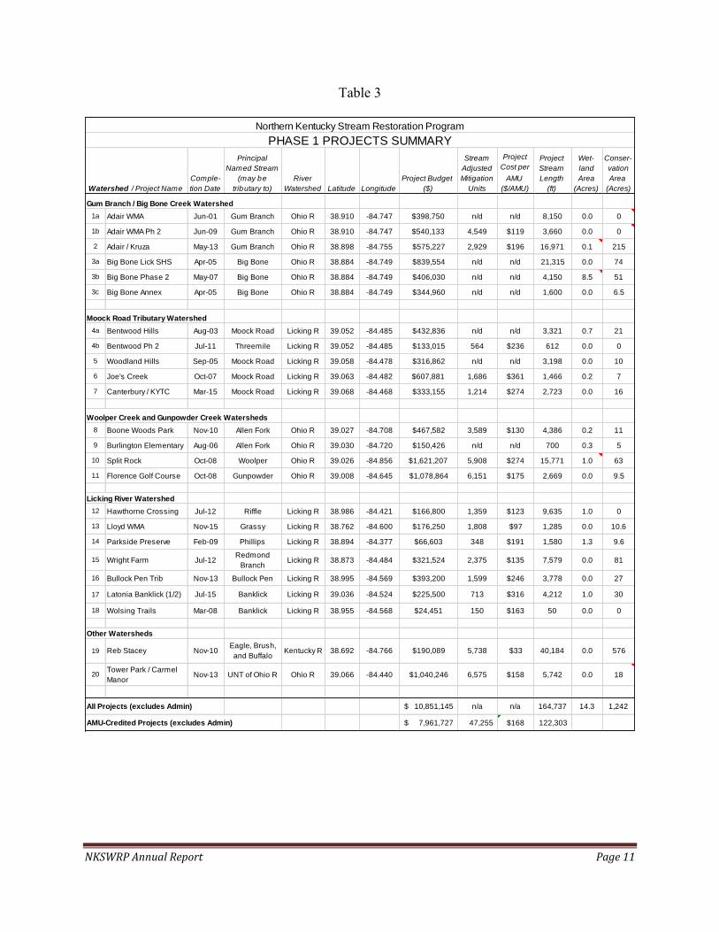
NKSWRP Annual Report Page 11
Table 3
Comple-
tion Date
Principal
Named Stream
(may be
tributary to)
River
Watershed Latitude Longitude
Project Budget
($)
Stream
Adjusted
Mitigation
Units
Project
Cost per
AMU
($/AMU)
Project
Stream
Length
(ft)
Wet-
land
Area
(Acres)
Conser-
vation
Area
(Acres)
Gum Branch / Big Bone Creek Watershed
1a Adair WMA Jun-01 Gum Branch Ohio R 38.910 -84.747 $398,750 n/d n/d 8,150 0.0 0
1b Adair WMA Ph 2 Jun-09 Gum Branch Ohio R 38.910 -84.747 $540,133 4,549 $119 3,660 0.0 0
2 Adair / Kruza May-13 Gum Branch Ohio R 38.898 -84.755 $575,227 2,929 $196 16,971 0.1 215
3a Big Bone Lick SHS Apr-05 Big Bone Ohio R 38.884 -84.749 $839,554 n/d n/d 21,315 0.0 74
3b Big Bone Phase 2 May-07 Big Bone Ohio R 38.884 -84.749 $406,030 n/d n/d 4,150 8.5 51
3c Big Bone Annex Apr-05 Big Bone Ohio R 38.884 -84.749 $344,960 n/d n/d 1,600 0.0 6.5
Moock Road Tributary Watershed
4a Bentwood Hills Aug-03 Moock Road Licking R 39.052 -84.485 $432,836 n/d n/d 3,321 0.7 21
4b Bentwood Ph 2 Jul-11 Threemile Licking R 39.052 -84.485 $133,015 564 $236 612 0.0 0
5 Woodland Hills Sep-05 Moock Road Licking R 39.058 -84.478 $316,862 n/d n/d 3,198 0.0 10
6 Joe's Creek Oct-07 Moock Road Licking R 39.063 -84.482 $607,881 1,686 $361 1,466 0.2 7
7 Canterbury / KYTC Mar-15 Moock Road Licking R 39.068 -84.468 $333,155 1,214 $274 2,723 0.0 16
Woolper Creek and Gunpowder Creek Watersheds
8 Boone Woods Park Nov-10 Allen Fork Ohio R 39.027 -84.708 $467,582 3,589 $130 4,386 0.2 11
9 Burlington Elementary Aug-06 Allen Fork Ohio R 39.030 -84.720 $150,426 n/d n/d 700 0.3 5
10 Split Rock Oct-08 Woolper Ohio R 39.026 -84.856 $1,621,207 5,908 $274 15,771 1.0 63
11 Florence Golf Course Oct-08 Gunpowder Ohio R 39.008 -84.645 $1,078,864 6,151 $175 2,669 0.0 9.5
Licking River Watershed
12 Hawthorne Crossing Jul-12 Riffle Licking R 38.986 -84.421 $166,800 1,359 $123 9,635 1.0 0
13 Lloyd WMA Nov-15 Grassy Licking R 38.762 -84.600 $176,250 1,808 $97 1,285 0.0 10.6
14 Parkside Preserve Feb-09 Phillips Licking R 38.894 -84.377 $66,603 348 $191 1,580 1.3 9.6
15 Wright Farm Jul-12Redmond
BranchLicking R 38.873 -84.484 $321,524 2,375 $135 7,579 0.0 81
16 Bullock Pen Trib Nov-13 Bullock Pen Licking R 38.995 -84.569 $393,200 1,599 $246 3,778 0.0 27
17 Latonia Banklick (1/2) Jul-15 Banklick Licking R 39.036 -84.524 $225,500 713 $316 4,212 1.0 30
18 Wolsing Trails Mar-08 Banklick Licking R 38.955 -84.568 $24,451 150 $163 50 0.0 0
Other Watersheds
19 Reb Stacey Nov-10Eagle, Brush, and Buffalo
Kentucky R 38.692 -84.766 $190,089 5,738 $33 40,184 0.0 576
20 Tower Park / CarmelManor
Nov-13 UNT of Ohio R Ohio R 39.066 -84.440 $1,040,246 6,575 $158 5,742 0.0 18
All Projects (excludes Admin) 10,851,145$ n/a n/a 164,737 14.3 1,242
AMU-Credited Projects (excludes Admin) 7,961,727$ 47,255 $168 122,303
Northern Kentucky Stream Restoration ProgramPHASE 1 PROJECTS SUMMARY
Watershed / Project Name

NKSWRP Annual Report Page 12
Table 4
Project Name Status
Final
Land
Owner
Conser-
vation
Acres
Stream
Feet
Price /
Acre
Total
Land
Cost
$M
Est'd
Project
Cost
$M
Est'd
Land +
Project
$M
Est'd
Stream
AMUs
Est'd
Wetlnd
AMUs
Est'd
Land +
Project
$/AMU
Est'd
Total
$/AMU
incl
Admin
KENTUCKY UTILITIESBig Bone Phase 3 (Piner) Mit Plan KY Parks 229 30,325 3,500$ 0.8$ 3.0$ 3.8$ 15,674 - 242$ 303$
Kingsolver Tract 1 (Preservation) Mit Plan KDFWR 540 33,082 1,500$ 0.8$ 0.7$ 1.5$ 4,941 - 306$ 382$ (1)
Sleepy Hollow Tract 1 Mit Plan SHC 876 85,695 1,700$ 1.5$ 1.0$ 2.5$ 19,945 - 125$ 156$
Stephens Creek Construct KDFWR 398 37,472 2,846$ 1.1$ 1.3$ 2.4$ 8,896 - 273$ 342$
St Annes Wetlands Mit Plan CCCD - - -$ -$ 0.3$ 0.3$ - 10.9 -$ -$
TOTAL 2,042 186,574 4.2$ 6.3$ 10.6$ 49,456 10.9 207$ 259$ (2)
PHASE 2Darlington Farm Mit Plan HOA 4 1,030 -$ -$ 0.2$ 0.2$ 2,290 - 87$ 127$
Kingsolver Tract 1 (Restoration) Mit Plan KDFWR - 3,048 -$ -$ 2.7$ 2.7$ 11,239 - 240$ 348$
Kingsolver Tract 2 (Preservation) Mit Plan KDFWR 405 21,265 1,512$ 0.6$ -$ 0.6$ 1,849 - 331$ 480$ (3)
Kingsolver Tract 2 (Restoration) Mit Plan KDFWR - 9,271 -$ -$ 2.3$ 2.3$ 8,371 - 275$ 398$
Sleepy Hollow Tracts 2 & 3 Mit Plan SHC 623 46,641 1,700$ 1.1$ 0.2$ 1.3$ 7,562 - 167$ 241$
1,032 81,255 1.7$ 5.4$ 7.1$ 31,311 226$ 327$ (4)
Notes:
(1) - Mitigation credits based upon preservation of good/exc ephemeral reaches. Land cost incl survey, legal, 106, CP, CEC design, boundary control, transfer to KDFWR, road relocation.
(2) - Project credit generation subject to revision up to close-out. Final KU projects scope/credits may be budget l imited. Total Admin 20%. $/AMU excludes wetlands.
(3) - Mitigation credits based upon preservation of good/excellent plus fair/average (nat'l recovery and watershed protection) reaches. Land cost incl survey, legal, 106, etc.
(4) - Project credit generation subject to revision up to close-out. Total Admin 31%.
PHASE 2 - UNDER NEGOTIATIONSt Annes / D*** pre-contr CCCD/DE 25 5,064 6,000$ 0.2$ 1.2$ 1.4$ 3,855 - 350$ 508$ (*)
Big Bone Phase 4 pre-contr KY Parks
(*) - Conservation acres includes new D*** CA only; CCCD already conserved via KHLCF.
Northern Kentucky Stream Restoration Program
KU AND PHASE 2 PROJECTS SUMMARY
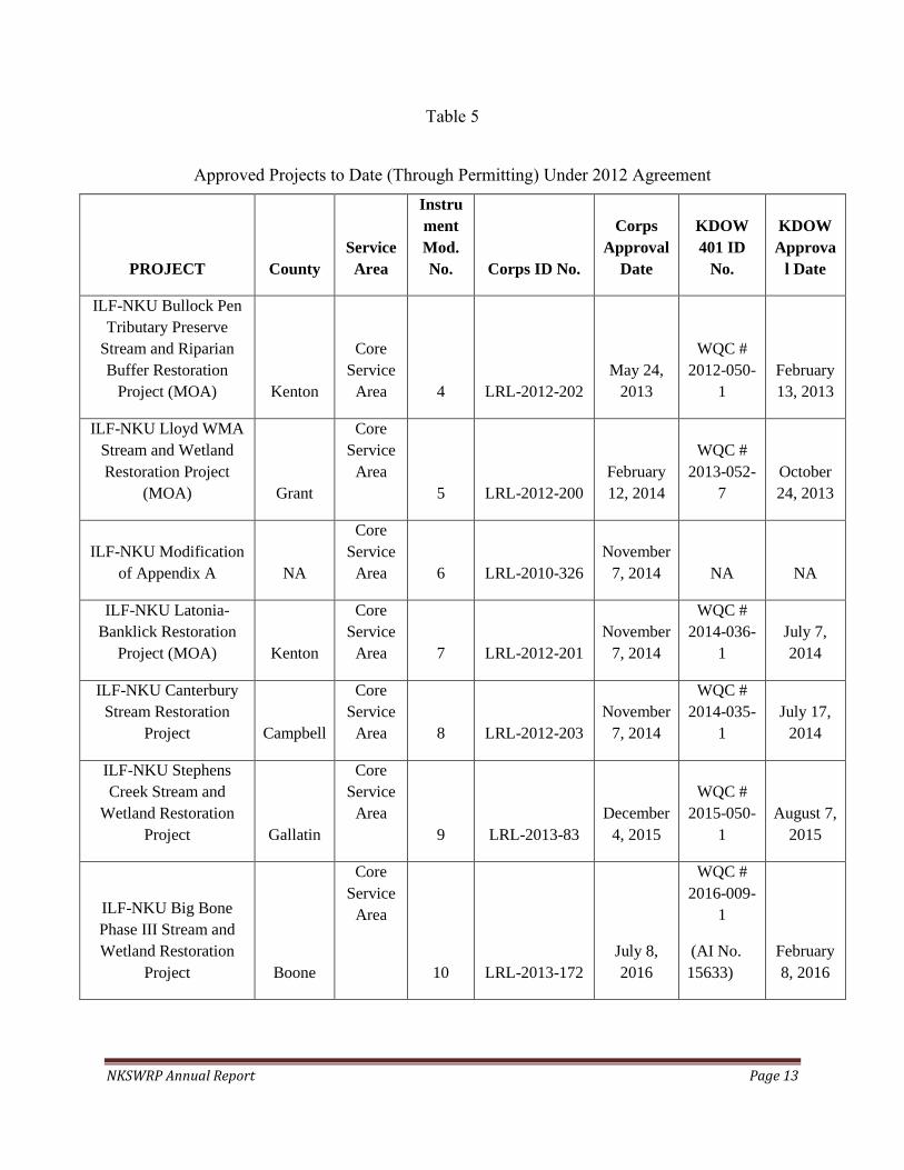
NKSWRP Annual Report Page 13
Table 5
Approved Projects to Date (Through Permitting) Under 2012 Agreement
PROJECT County
Service
Area
Instru
ment
Mod.
No. Corps ID No.
Corps
Approval
Date
KDOW
401 ID
No.
KDOW
Approva
l Date
ILF-NKU Bullock Pen
Tributary Preserve
Stream and Riparian
Buffer Restoration
Project (MOA) Kenton
Core
Service
Area 4 LRL-2012-202
May 24,
2013
WQC #
2012-050-
1
February
13, 2013
ILF-NKU Lloyd WMA
Stream and Wetland
Restoration Project
(MOA) Grant
Core
Service
Area
5 LRL-2012-200
February
12, 2014
WQC #
2013-052-
7
October
24, 2013
ILF-NKU Modification
of Appendix A NA
Core
Service
Area 6 LRL-2010-326
November
7, 2014 NA NA
ILF-NKU Latonia-
Banklick Restoration
Project (MOA) Kenton
Core
Service
Area 7 LRL-2012-201
November
7, 2014
WQC #
2014-036-
1
July 7,
2014
ILF-NKU Canterbury
Stream Restoration
Project Campbell
Core
Service
Area 8 LRL-2012-203
November
7, 2014
WQC #
2014-035-
1
July 17,
2014
ILF-NKU Stephens
Creek Stream and
Wetland Restoration
Project Gallatin
Core
Service
Area
9 LRL-2013-83
December
4, 2015
WQC #
2015-050-
1
August 7,
2015
ILF-NKU Big Bone
Phase III Stream and
Wetland Restoration
Project Boone
Core
Service
Area
10 LRL-2013-172
July 8,
2016
WQC #
2016-009-
1
(AI No.
15633)
February
8, 2016

NKSWRP Annual Report Page 14
Fund Report
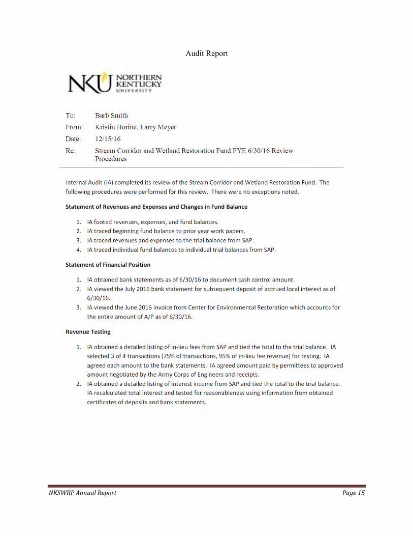
NKSWRP Annual Report Page 15
Audit Report

NKSWRP Annual Report Page 16
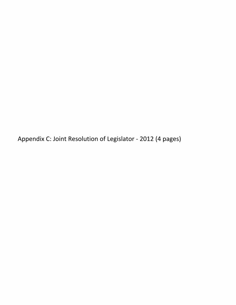
Appendix C: Joint Resolution of Legislator - 2012 (4 pages)


Appendix D: SB203, filed by Senator John Schickel (4 pages)
UNOFFICIAL COPY AS OF 12/16/15 15 REG. SESS. 15 RS BR 1355
Page 1 of 4 BR135500.100 - 1355 - 4010 Jacketed
AN ACT relating to stream restoration and mitigation funds and making an
appropriation therefor.
Be it enacted by the General Assembly of the Commonwealth of Kentucky:
Section 1. KRS 150.255 is amended to read as follows:
(1) Upon request of any state agency or any other entity, the department may contract
with the agency or party to undertake any compensatory mitigation project,
including, but not limited to, wetland or stream mitigation.
(2) The department may establish and manage wetland or stream compensatory
mitigation banks, the purpose of which shall be to restore, create, or enhance
wetlands and streams as compensatory mitigation where a state agency or other
party is required to provide compensatory mitigation, and where the use of banked
mitigation is approved by the agency requiring mitigation. The department may
create the bank in advance of requests for banked mitigation credits.
(3) There is established and created in the State Treasury the "Kentucky Wetland and
Stream Mitigation Fund" for the purpose of restoring, creating, enhancing, or
preserving the Commonwealth's wetlands or streams that may be damaged or
destroyed due to any project, recovering costs associated with performing these
projects, funding infrastructure projects that preserve and enhance the aquatic
resources of the Commonwealth, and administering these programs. The fund shall
be deemed a trust and agency fund account and made available solely for the
purposes and benefits of the Kentucky wetland and stream mitigation projects,
including infrastructure projects. The fund may receive state appropriations, gifts,
grants, federal funds, revolving funds, and any other funds both public and private.
Money deposited in the fund shall be disbursed by the State Treasurer upon the
request of the commissioner with the approval of the commission. Twenty-five
percent (25%) of in-lieu fees contributed to the fund by permittees for
compensatory mitigation projects shall be allocated solely for use on
UNOFFICIAL COPY AS OF 12/16/15 15 REG. SESS. 15 RS BR 1355
Page 2 of 4 BR135500.100 - 1355 - 4010 Jacketed
infrastructure projects that preserve or enhance the aquatic resources of the
Commonwealth. Any unallocated or unencumbered balance in the fund shall be
invested as provided in KRS 42.500(9), and any income earned from the
investments, along with the unallocated or unencumbered balance in the fund, shall
not lapse.
(4) As used in this section, "infrastructure project" means the extension of sewer
lines, the extension of water lines, improvements to existing sewer and water
infrastructure, roadway improvements that incorporate green infrastructure, and
repair and maintenance of regional storm water systems, natural features, and
waterways.
Section 2. KRS 151.611 is amended to read as follows:
(1) A Stream Restoration and Mitigation Authority may be established for any HUC 10
watershed in the Commonwealth. Each authority formed under this section shall be
a public body corporate and politic with the authority to:
(a) Sue and be sued;
(b) Enter into contracts with public and private individuals and corporations and
engage in cooperative agreements with federal, state, and local governments
or agencies, utilities, special districts, and nonprofit organizations for the
performance of its duties and functions under KRS 151.610 to 151.615;
(c) Employ personnel as needed, as its fiscal resources may allow, and use the
services of volunteers individually or through agreement with governmental
agencies, nonprofit organizations, or foundations;
(d) Receive and expend funds from any source, including but not limited to
private donations, charitable contributions, public grants, 404 In-lieu Fee
Program, and appropriations from the General Assembly; and
(e) Acquire, sell, and hold real interests in property.
(2) Nothing in KRS 151.610 to 151.615 shall be construed to empower or authorize an
UNOFFICIAL COPY AS OF 12/16/15 15 REG. SESS. 15 RS BR 1355
Page 3 of 4 BR135500.100 - 1355 - 4010 Jacketed
authority established under KRS 151.610 to 151.615 to exercise regulatory powers
with respect to water resources or water quality. An authority established under
KRS 151.610 to 151.615 shall not be vested with the power of eminent domain.
(3) It is the preference of the General Assembly that funds contributed by a permittee
under a Section 404 Permit into an in-lieu fund for a project designed for stream
restoration and mitigation be utilized within the watershed where the adverse effects
occur. The General Assembly recognizes that conservation and protection of the
water resources of the Commonwealth, including streams, rivers, wetlands, and
riparian habitats, may involve, in addition to restoration and enhancement of aquatic
and riparian habitat, proper management of wastewater and stormwater, and
abatement of pre-existing sources of pollution. Therefore, each authority shall
allocate twenty-five percent (25%) of moneys received into an in-lieu fund for use
solely on infrastructure projects that preserve or enhance the aquatic resources of
the Commonwealth. Where an authority has been qualified by the USACE to
manage an in-lieu fee or other compensatory mitigation arrangement that is
approved after July 15, 2008, under Section 404, and to the extent that the USACE
and the Mitigation Review Team has approved the use of such funds for elimination
of pre-existing sources of pollution, the authority may expend the remaining
seventy-five percent (75%)[a portion] of the funds for non-infrastructure
projects[those purposes], provided that the:
(a) Funds spent on water quality improvements are a component of a stream or
wetland restoration plan for replacement of aquatic resource functions and
values; and
(b) Project has been reviewed and approved by the USACE and the Division of
Water as being consistent with Sections 404 and 401 of the Clean Water Act.
(4) Nothing in KRS 151.610 to 151.615 shall preclude the authority, when acting as an
approved qualified organization managing an in-lieu fee arrangement approved after

UNOFFICIAL COPY AS OF 12/16/15 15 REG. SESS. 15 RS BR 1355
Page 4 of 4 BR135500.100 - 1355 - 4010 Jacketed
July 15, 2008, from combining funding from other sources with in-lieu fees in order
to achieve efficiencies in stream restoration or mitigation.
(5) As used in this section, "infrastructure project" means the extension of sewer
lines, the extension of water lines, improvements to existing sewer and water
infrastructure, roadway improvements that incorporate green infrastructure, and
repair and maintenance of regional storm water systems, natural features, and
waterways.
Appendix E: Final Report of the Assumable Waters Subcommittee (72 pages)
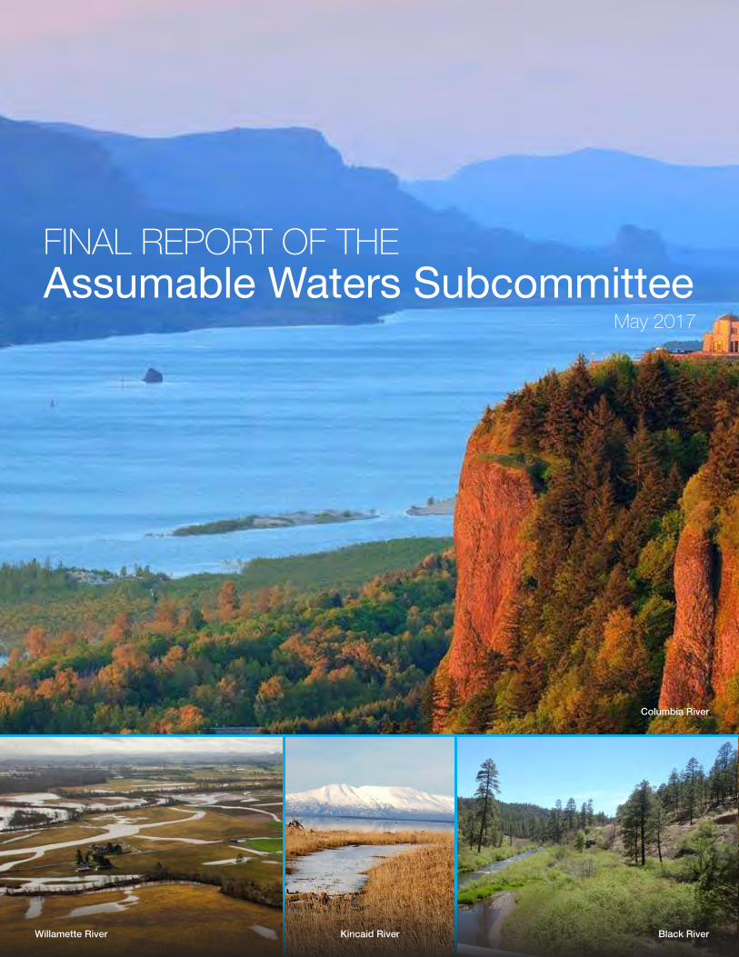
FINAL REPORT OF THEAssumable Waters Subcommittee
May 2017
Columbia River
Black RiverWillamette River Kincaid River

Intentionally left blank
Report of the Assumable Waters NACEPT Subcommitteei
Table of ContentsExecutive Summary ..................................................................................................................................iii
Problem Statement ........................................................................................................................................... iii
Underlying Assumptions ................................................................................................................................... iv
Subcommittee Activities .................................................................................................................................... iv
Subcommittee Findings and Recommendations .................................................................................................v
Implementation and Process Recommendations ................................................................................................vi
1. Statement of the Problem ................................................................................................................... 1
2. Background ....................................................................................................................................... 2
What is Assumption? ........................................................................................................................................ 2
Tribal Considerations Regarding Assumption ..................................................................................................... 3
Overview of Assumption by Michigan and New Jersey ....................................................................................... 3
No Further Assumption by States or Tribes Since the 1990s .............................................................................. 5
The Importance of Assumption to States and Tribes ........................................................................................... 5
Establishment of the Subcommittee .................................................................................................................. 6
Operation of the Subcommittee ........................................................................................................................ 7
About the Writing of this Report ......................................................................................................................... 7
3. Origin and Purpose of Section 404(g) ................................................................................................. 9
Organization of the Work Group ........................................................................................................................ 9
Background on Navigable Waters to be Retained by the USACE as Defined in Section 404(g)(1) ......................... 9
Background on Adjacent Wetlands to be Retained by the USACE .................................................................... 11
4. Description of Alternatives for Identifying Waters (other than Wetlands) Assumable by a State or Tribe, and Waters that Must be Retained by the USACE ................................................ 13
Waters Alternative A ........................................................................................................................................ 14
Waters Alternative B ........................................................................................................................................ 14
Waters Alternative C ....................................................................................................................................... 15
Report of the Assumable Waters NACEPT Subcommitteeii
5. Subcommittee Discussion and Recommendations for Identifying Retained Waters ............................. 17
Majority Recommendation ............................................................................................................................... 17
USACE Recommendation ............................................................................................................................... 21
6. Description of Alternatives for Identifying Adjacent Wetlands Assumable by a State or Tribe, and Adjacent Wetlands that Must be Retained by the USACE .............................. 23
Wetlands Alternative A .................................................................................................................................... 24
Wetlands Alternative B .................................................................................................................................... 25
Wetlands Alternative C .................................................................................................................................... 25
7. Subcommittee Discussion and Recommendations on Identifying Adjacent Wetlands ........................ 29
Majority Recommendation ............................................................................................................................... 29
USACE Recommendation ............................................................................................................................... 34
8. Implementation and Process Recommendations ............................................................................... 35
Maintain Michigan and New Jersey 404 Assumed Programs ............................................................................ 35
Develop Guidance for the Field ....................................................................................................................... 35
Provide Flexibility ............................................................................................................................................. 36
Incorporate National Principles and Considerations into Field Guidance ............................................................. 36
Provide General Procedures for the Assumption Process ................................................................................. 37
Utilize Best Available Technology ..................................................................................................................... 38
Appendix A: Tribal Findings, Issues, and Considerations during Assumption ........................................... 39
Appendix B: Michigan and New Jersey’s Assumed Programs ................................................................ 41
Appendix C: Letter from the Association of Clean Water Administrators, the Environmental Council of the States, and the Association of State Wetland Managers ......................... 47
Appendix D: List of Subcommittee Members ......................................................................................... 50
Appendix E: Subcommittee Charter ....................................................................................................... 52
Appendix F: The Legislative History of Section 404(g)(1) of the Clean Water Act ...................................... 55
Report of the Assumable Waters NACEPT Subcommitteeiii
Executive SummaryPROBLEM STATEMENT
Section 404 of the Clean Water Act (CWA) authorizes the US Army Corps of Engineers (USACE) to issue permits for discharge of dredged or fill material in navigable waters. “Navigable waters” is defined under the CWA to mean “the waters of the United States and territorial seas.” Section 404(g) of the CWA authorizes states,1 with approval from the US Environmental Protection Agency (EPA), to assume authority to administer the 404 program in some, but not all, navigable waters and adjacent wetlands. Section 404(g)(1) describes the waters over which the USACE must retain administrative authority even after program assumption by a state or tribe.
Only two states, Michigan and New Jersey, have been approved to assume the Section 404 Program. Other states have explored assumption, but those efforts have not borne fruit in part due to uncertainty over the scope of assumable waters and wetlands. The EPA formed the Assumable Waters Subcommittee under the auspices of the National Advisory Council for Environmental Policy and Technology (NACEPT) to provide advice and develop recommendations for NACEPT on how the EPA can best clarify for which waters a state or tribe may assume CWA section 404 permit responsibilities, and for which waters the USACE retains CWA section 404 permit responsibility under an approved state or tribal program. The Subcommittee included 22 members representing states and tribes, federal agencies, and other stakeholders. This report represents the results of the Subcommittee’s work from October 2015 to April 2017 and is being presented to NACEPT for its consideration.
1 Tribes were not specifically called out in the 1977 CWA amendments but are able to assume as provided in Section 518(e) of the CWA.
Report of the Assumable Waters NACEPT Subcommitteeiv
UNDERLYING ASSUMPTIONS
Recommendations to the NACEPT were developed against the background of the following assumptions.
• In accordance with the requirements of Section 404, a state or tribe may only be authorized to assume the Section 404 Program if it has authority over all assumable waters of the United States, and demonstrates that it will apply legal standards consistent with the Clean Water Act (CWA) requirements in operating a permitting program.
• Assumption by a state or tribe does not alter CWA jurisdiction over waters of the United States. Moreover, nothing in the report or recommendations of the subcommittee is intended to alter in any way the definition or scope of federal jurisdiction. Rather, this report speaks only to the administrative division of authority under Section 404 between the USACE and an approved state or tribe.
• In accordance with EPA’s charge to the subcommittee, recommendations are intended to provide clarity, to be practical and readily implementable in the field, and to be consistent with the CWA, particularly Section 404(g)(1).
• Waters, such as rivers, lakes, and streams, and adjacent wetlands are clearly linked legally, in policy, and in hydrology, and in total are often referred to as “waters.” However, for the purposes of developing recommendations and for usage in this report, the Subcommittee chose the use of two terms: “waters” and “adjacent wetlands.”
• Since the EPA will be receiving formal advice from the NACEPT, the EPA participated actively in the discussion, formulation, and review of the alternatives and provided technical advice, but did not take a position regarding the specific recommendations made by the Subcommittee. The US FWS also participated in the discussions but did not take a position on the final recommendations. Members who took a position regarding the recommendations are referred to as “recommending members.” These include all members, including the USACE, but not the US EPA and the US FWS.
SUBCOMMITTEE ACTIVITIES
Subcommittee members met eight times and also worked independently from October 2015 through April 2017. Investigations and discussions were divided into three primary topics.
• The origins, legislative history, and processes of Section 404 state or tribal assumption. Subcommittee members, including attorneys and others, reviewed the language of Section 404(g), the legislative history, and other policy documents. The full findings of this group are included in Appendix F. The histories of the programs in Michigan and New Jersey are included in Appendix B.
• The extent of waters of the United States that may be assumed by an approved state or tribe, and the extent of waters where Section 404 authority must be retained by the USACE, even following state or tribal assumption. Findings and recommendations are discussed in detail in this report.
• The extent of wetlands that must also be retained by the USACE following state or tribal assumption. Findings and recommendations are discussed in detail in this report.
Report of the Assumable Waters NACEPT Subcommitteev
SUBCOMMITTEE FINDINGS AND RECOMMENDATIONS
Waters (other than Wetlands) Assumable by a State or Tribe, and Waters that Must be Retained by the USACE
MAJORITY RECOMMENDATION. All the recommending Subcommittee members (the majority) except the member representing the USACE recommend to NACEPT that the EPA develop guidance or regulations to clarify that when a state or tribe assumes the 404 program, the USACE must retain authority over waters included on lists of waters regulated under Section 10 of the Rivers and Harbors Act (RHA). These lists are compiled and maintained by the USACE district offices for every state except Hawaii, and the majority of the Subcommittee recommends the lists be used with two minor modifications: any waters that are on the Section 10 lists based solely on historic use (e.g. based solely on historic fur trading) are not to be retained (based on the Congressional record and statute), and waters that are assumable by a tribe (as defined in the report) may also be retained by the USACE when a state assumes the program. The majority recognizes that waters may be added to Section 10 lists after a state or tribe assumes the program, and recommends in that case, such waters may also be added to lists of USACE-retained waters at that time.
The majority believes that this option is clear and practical, can be implemented efficiently at the time a state or tribe seeks assumption as well as in the operation of an assumed program, and is consistent with Congress’ intent that the USACE retain authority over RHA Section 10 waters and adjacent wetlands. This alternative also is based on relatively stable and predictable information.
All other waters of the United States (with the exception of adjacent wetlands as discussed below) are assumable by a state or tribe.
MINORITY RECOMMENDATION. The Subcommittee member representing the USACE recommends USACE retain authority over waters on the Section 10 lists, and also waters that have been identified as Traditional Navigable Waters (TNWs) under the CWA in accordance with USACE CWA regulations at 33 CFR 328.3(a)(1) and guidance issued by the USACE and the EPA to implement the Supreme Court’s opinion in Rapanos, Appendix D.2 Under this recommendation waters that are officially determined by a USACE district as Section 10 or stand-alone CWA (a)(1) TNW waters at the time a state or tribe assumes the program would be retained by the USACE. In addition, the District would evaluate all of its completed case-specific TNW determinations to determine whether addition of that water to the retained waters list is warranted under a stand-alone determination. Waters that are later identified and officially determined as a Section 10 or stand-alone CWA(a)(1) TNW after assumption occurs will also be added to the list of retained waters. The USACE believes there should not be a distinction between different uses of the term “navigable waters” under different sections of the statute, and believes this is consistent with the purposes of the CWA and Section 404(g). While the statutory language of the CWA Section 404(g) parenthetical waters slightly differs from the regulatory language of 328.3(a)(1), the USACE believes the interpretation of the term “navigable waters” is the same under 404(g) and 328.3(a)(1) (other than those waters considered navigable based solely on their historic use).
2 Appendix D of the 2007 “US Army Corps of Engineers Jurisdictional Determination Instructional Guidebook” available at: http://www.usace.army.mil/Portals/2/docs/civilworks/regulatory/cwa_guide/ app_d_traditional_navigable_waters.pdf. The Guidebook, of which Appendix D is part, was dated 1 June 2007 and signed by USACE and the US EPA on 5 June 2007.
Report of the Assumable Waters NACEPT Subcommitteevi
Adjacent Wetlands Assumable by a State or Tribe, and Adjacent Wetlands that Must be Retained by the USACE
MAJORITY RECOMMENDATION. All the recommending Subcommittee members (the majority) except for the USACE member recommend that the EPA adopt and implement a policy under which the USACE would retain administrative authority over all wetlands adjacent to retained navigable waters landward to an administrative boundary agreed upon by the state or tribe and the USACE. The USACE CWA regulatory definition of “adjacent” would be used to identify adjacent wetlands, and the USACE would retain administrative authority only over adjacent wetlands within the agreed-upon administrative boundary. This administrative line could be negotiated at the state or tribal level to take into account existing state regulations or natural features that would increase practicability or public understanding; if no change were negotiated, a 300-foot national administrative default line would be used.
The majority of the subcommittee understands that the purpose of retention by the USACE of wetlands adjacent to Section 10 waters is primarily to ensure that the USACE has authority over activities that may alter the physical structure of the navigational channel or otherwise interfere with navigation. Thus, it believes that the extent of USACE authority over adjacent wetlands under an assumed program is reasonably limited to wetlands that are likely to affect navigation.
MINORITY RECOMMENDATION. The representative of the USACE recommends that the USACE retain the entirety of wetlands that are “adjacent” to retained navigable waters, using the definition of adjacent wetlands currently being used by the USACE for regulatory actions under Section 404 (i.e. the wetlands defined as adjacent under 33 CFR 328.3, implemented through the 2008 Rapanos guidance). The USACE believes that this recommendation is consistent with CWA Section 404, provides clarity regarding the permitting authority, and is easily understood and implementable in the field.
IMPLEMENTATION AND PROCESS RECOMMENDATIONS
This report also provides general recommendations regarding the potential content of new guidance or regulations on state or tribal assumable waters, and effective procedures for implementation.
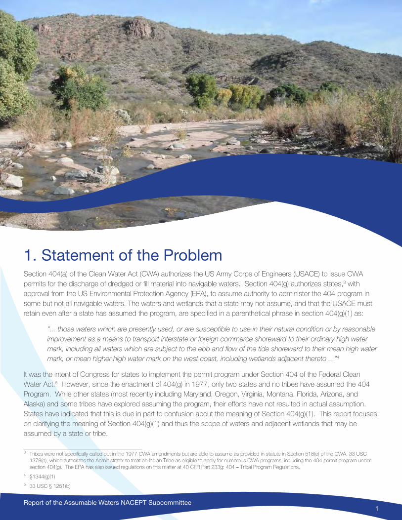
Report of the Assumable Waters NACEPT Subcommittee1
1. Statement of the ProblemSection 404(a) of the Clean Water Act (CWA) authorizes the US Army Corps of Engineers (USACE) to issue CWA permits for the discharge of dredged or fill material into navigable waters. Section 404(g) authorizes states,3 with approval from the US Environmental Protection Agency (EPA), to assume authority to administer the 404 program in some but not all navigable waters. The waters and wetlands that a state may not assume, and that the USACE must retain even after a state has assumed the program, are specified in a parenthetical phrase in section 404(g)(1) as:
“... those waters which are presently used, or are susceptible to use in their natural condition or by reasonable improvement as a means to transport interstate or foreign commerce shoreward to their ordinary high water mark, including all waters which are subject to the ebb and flow of the tide shoreward to their mean high water mark, or mean higher high water mark on the west coast, including wetlands adjacent thereto ...”4
It was the intent of Congress for states to implement the permit program under Section 404 of the Federal Clean Water Act.5 However, since the enactment of 404(g) in 1977, only two states and no tribes have assumed the 404 Program. While other states (most recently including Maryland, Oregon, Virginia, Montana, Florida, Arizona, and Alaska) and some tribes have explored assuming the program, their efforts have not resulted in actual assumption. States have indicated that this is due in part to confusion about the meaning of Section 404(g)(1). This report focuses on clarifying the meaning of Section 404(g)(1) and thus the scope of waters and adjacent wetlands that may be assumed by a state or tribe.
3 Tribes were not specifically called out in the 1977 CWA amendments but are able to assume as provided in statute in Section 518(e) of the CWA, 33 USC 1378(e), which authorizes the Administrator to treat an Indian Tribe as eligible to apply for numerous CWA programs, including the 404 permit program under section 404(g). The EPA has also issued regulations on this matter at 40 CFR Part 233g: 404 – Tribal Program Regulations.
4 §1344(g)(1)5 33 USC § 1251(b)
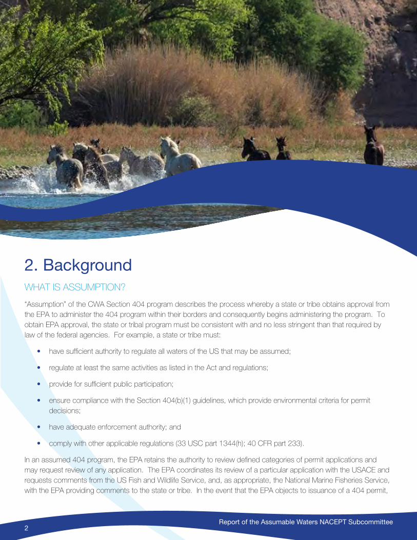
Report of the Assumable Waters NACEPT Subcommittee2
2. BackgroundWHAT IS ASSUMPTION?
“Assumption” of the CWA Section 404 program describes the process whereby a state or tribe obtains approval from the EPA to administer the 404 program within their borders and consequently begins administering the program. To obtain EPA approval, the state or tribal program must be consistent with and no less stringent than that required by law of the federal agencies. For example, a state or tribe must:
• have sufficient authority to regulate all waters of the US that may be assumed;
• regulate at least the same activities as listed in the Act and regulations;
• provide for sufficient public participation;
• ensure compliance with the Section 404(b)(1) guidelines, which provide environmental criteria for permit decisions;
• have adequate enforcement authority; and
• comply with other applicable regulations (33 USC part 1344(h); 40 CFR part 233).
In an assumed 404 program, the EPA retains the authority to review defined categories of permit applications and may request review of any application. The EPA coordinates its review of a particular application with the USACE and requests comments from the US Fish and Wildlife Service, and, as appropriate, the National Marine Fisheries Service, with the EPA providing comments to the state or tribe. In the event that the EPA objects to issuance of a 404 permit,

Report of the Assumable Waters NACEPT Subcommittee3
the state or tribe cannot issue the 404 permit unless the EPA’s objection is resolved. If the objection is not resolved, the USACE takes responsibility for the permit, including the decision to issue or deny the permit. These provisions of federal law provide safeguards that ensure consideration of both state or tribal and federal requirements as well as national consistency.
Before assuming the program, the state or tribe must enter into and sign separate Memoranda of Agreement (MOAs) with both the EPA and USACE. The MOA with the USACE must describe which navigable waters and adjacent wetlands will be retained by the USACE. To date, there has been little guidance to USACE districts, EPA regions, or states and tribes on how to make that determination.6
TRIBAL CONSIDERATIONS REGARDING ASSUMPTION7
Section 518 of the CWA, enacted as part of the 1987 amendments to the statute, authorizes the EPA to treat eligible Indian tribes in a manner similar to states (“treatment as a state“ or TAS) for a variety of purposes, including administering each of the principal CWA regulatory programs and receiving grants under several CWA authorities (81 FR at 30183). This includes CWA Section 404. Tribal governments pursuing assumption of the 404 program will follow the same process as states, though it is expected that there will be some nuanced differences; for example, in addressing Tribal Indian Reservation boundaries.
In a state-assumed program, states will generally not assume authority for administering the 404 program within Indian country; instead, such authority will generally be retained by the USACE unless the tribe itself is approved by the EPA to assume the 404 program. Because Tribal Indian Reservation boundaries are not static and precise definitions and considerations vary from state to state, it is essential that waters to be retained by the USACE on tribal lands be specifically addressed in any MOA developed between the USACE and a state assuming the program.
Per Executive Order 13175 of November 6, 2000 – Consultation and Coordination With Indian Tribal Governments,8 the federal government has an obligation to consult with federally-recognized tribes that may be affected during a state assumption effort.
OVERVIEW OF ASSUMPTION BY MICHIGAN AND NEW JERSEY
Since Section 404(g) was enacted in 1977, two states have assumed the program: Michigan and New Jersey.
Michigan and EPA signed a MOA regarding assumption in 1983. In 1984, the state and the USACE signed a MOA describing waters over which the USACE retained administration. Prior to assumption, Michigan had enacted a number of statutes related to water protection, including the 1955 Great Lakes Submerged Lands Act, the 1972
6 In 1980, the EPA produced a document entitled: “The State’s Choice: 404 Permit Program” that provides some insight into the agency’s thinking at that time (US EPA, Office of Water Regulations and Standards Criteria and Standards Division, EPA 440/5-81-002, October 1980). The EPA’s implementing regulations also provide very general guidance. These regulations state that the MOA between the USACE and state or tribe will contain “A description of waters of the United States within the State over which the Secretary retains jurisdiction, as identified by the Secretary.” 40 CFR Part 233: 404 State Program Regulations.
7 See Appendix A, Tribal Findings, Issues, and Considerations during Assumption.8 Federal Register Vol. 65, No. 218, pages 67249-67252.

Report of the Assumable Waters NACEPT Subcommittee4
Inland Lakes and Streams Act, and the 1979 Wetland Protection Act. The Wetland Protection Act was passed to facilitate assumption of the 404 Program. In 1984, EPA formally approved Michigan’s program.9
The waters and wetlands assumed by Michigan are described in the MOA between Michigan and the USACE. In this MOA, the USACE retains responsibility for waters that are on a Rivers and Harbors Act (RHA) Section 10 list maintained by the USACE district office. In addition, the USACE retains permitting authority over the Great Lakes, which although not on the list clearly qualify as Section 10 waters. This list is specific and results in well-defined boundaries and upstream limits for waters retained by the USACE. Most of these USACE-retained waters are within a narrow band of streams that flow into the Great Lakes. This list has been refined over time with the addition of some small tributaries and wetlands that are influenced by the water level of the Great Lakes. Michigan has assumed the remaining waters, which are the vast majority of the waters internal to the state.
The extent of adjacent wetlands over which the USACE retains authority is determined by the USACE on a case-by-case basis – generally including wetlands in close proximity to Section 10 waters, and having a direct surface water connection to and within the influence of the ordinary high water mark of those waters.
There are some waters over which Michigan and the USACE have joint authority. In these cases the two agencies work together on the permitting and compliance activities, and site inspections. Usually the state takes the lead on mitigation because the state has a robust mitigation program and can own property, hold conservation easements, and hold financial instruments, which the USACE cannot.
New Jersey assumed the program in 1994.10 Prior to assumption, New Jersey passed its Wetlands Act in 1970, Coastal Zone Management Act in 1972, and the Freshwater Wetlands Protection Act in 1987. As part of the Freshwater Wetlands Protection Act, New Jersey undertook a mapping program to identify freshwater wetlands and waters. While the maps are not regulatory in nature, New Jersey’s 404 program is keyed to these freshwater wetlands maps.
In the MOA between New Jersey and the USACE, the USACE retained regulatory authority over those wetlands that are: “... partially or entirely located within 1000 feet of the ordinary high water mark or mean high tide of the Delaware River, Greenwood Lake, and all water bodies which are subject to the ebb and flow of the tide.”11 State-administered waters in turn are generally determined by superimposing head of tide data on the state’s freshwater wetlands quarter quadrangles that are at a scale of one inch equals 1000 feet. A line was established parallel to and 1000 feet from the ordinary high water mark or mean high tide of the waters described above. The USACE retains permitting authority over all wetlands that are waterward of, or intersected by, the administrative line described above. Because New Jersey regulates all wetlands/waters, it rarely has to determine whether a wetland is assumable or non-assumable. However, if there is any question or a reason that it makes a difference to an applicant, the state either adds a permit condition informing the applicant or contacts the USACE in advance to request the USACE determine whether they will or will not assert authority to regulate. See Appendix B for further elaboration of these two states’ assumed programs.
9 49 FR 38948, Oct. 2, 1984. Redesignated at 53 FR 20776, June 6, 1988. Redesignated at 58 FR 8183, Feb. 11, 1993. Effective date, October 16, 1984.10 59 FR 9933, Mar. 2, 1994.11 Ibid.

Report of the Assumable Waters NACEPT Subcommittee5
NO FURTHER ASSUMPTION BY STATES OR TRIBES
SINCE THE 1990s
The legislative history and statute indicate that Congress intended and expected that a number of states would choose to assume authority over the discharge of dredged or fill materials under the provisions of Section 404(g). However, no states or tribes have assumed the 404 Program since Michigan and New Jersey. There are many possible reasons for this, from the increasing complexity and cost of administering the program, to decades-long challenges about which waters should even be regulated under Section 404, to the fact that unlike several other EPA programs, Congress did not dedicate specific additional funding for states or tribes to cover the costs of administering a 404 program. Additionally, EPA and the USACE have not provided specific guidance that can be used to identify the waters (and wetlands) that must be retained by the USACE under 404(g). Without specific guidance, individual states or tribes and USACE districts have been left to interpret the meaning of 404(g)(1) to determine the extent of waters to be retained in each MOA negotiation. In turn, these negotiations have often broken down or stopped due to lack of clarity, uncertainty, or disagreement over the scope of retained waters and wetlands.
THE IMPORTANCE OF ASSUMPTION TO STATES AND TRIBES
States and tribes play a significant role in many Clean Water Act programs (for example, point and nonpoint source management, waste management, wastewater permitting under Section 402, and development of water quality standards). In most CWA programs, states and tribes partner primarily with the EPA. Section 404 is unique in the sharing of regulatory responsibilities with the USACE in addition to EPA. For those states or tribes with mature, integrated water management programs that include the regulation of dredged or fill activities, 404 Program assumption allows a state or tribe to carry out a fully integrated and comprehensive water program addressing the full range of state, tribal, and CWA requirements. Despite the complexity of the program and potential administrative costs, states and tribes remain interested in pursuing assumption.
While not all states and tribes are qualified or positioned to assume Section 404 responsibility, or are willing to bear the additional cost of doing so, assumption may have significant benefits for some states and tribes, as well as the public. State or tribal assumption in accordance with Section 404(g) could reduce the overlap and duplication of state, tribal, and federal permitting programs, and be the best use of state, tribal, and federal program resources. This is, of course, dependent upon assurance that the state or tribal program is as stringent as is required by the federal statutes and regulations, an assurance required by the CWA and provided by initial EPA approval and by ongoing federal oversight. Assumption allows a state or tribe to meet state or tribal regulatory time constraints; to incorporate needed local requirements and permit conditions; and, to integrate review of applications for discharge of dredged or fill material with other applicable regulatory requirements. The public may be supportive of assumption and willing to accept the costs to a state or tribal government and the potentially higher permit fees given potentially significant streamlining of the permitting process for many projects.
Report of the Assumable Waters NACEPT Subcommittee6
ESTABLISHMENT OF THE SUBCOMMITTEE
In 2014, the Association of Clean Water Administrators, the Environmental Council of the States, and the Association of State Wetland Managers asked EPA to clarify which waters are assumable under the statute (see Appendix C for a copy of the request from the state associations). In response, EPA convened a stakeholder group to provide advice on this matter. To form the stakeholder group, EPA drew on its authority under the Federal Advisory Committee Act (FACA), Public Law 92-46312. In 1988, EPA established the National Advisory Council for Environmental Policy and Technology (NACEPT), a body subject to FACA, to provide advice to the EPA Administrator on a broad range of environmental policy, management, and technology issues. In March 2015, the Agency published a Federal Register Notice announcing that NACEPT would be establishing the Subcommittee to address the issue raised by the states and national organizations, and that it was seeking nominations for membership. In June of that year, EPA announced the appointment of 22 members representing federal, state, and tribal governments, non-governmental organizations and the regulated public (see Appendix D for a list of members and their affiliations).
EPA directed the Subcommittee to focus on a narrow and specific task related to the waters for which a state or tribe may assume permitting responsibility (see the Subcommittee Charter in Appendix E). The Subcommittee was asked to provide advice and develop recommendations for NACEPT on how EPA can best clarify for which waters a state or tribe may assume CWA section 404 permit responsibilities, and for which waters the USACE retains CWA section 404 permit responsibility under an approved state or tribal program.
As set forth in the Charter’s Charge to the Subcommittee: “this effort will address the States’ request to provide clarity on this issue enabling them to assess and determine the geographic scope and costs and benefits associated with implementing an approved program.” The Subcommittee has had a limited duration and narrow focus. Other aspects of state or tribal assumption were not within the scope of Subcommittee deliberations. In particular, the Charge emphasized that “the subcommittee will not be deliberating on the merits of assumption, nor on any aspect of the larger question of which waters are ‘waters of the US.’”
EPA asked that the final Subcommittee report to NACEPT reflect consideration of the following assumptions:
• A CWA section 404 permit is required – meaning there is an activity regulated under section 404 that will result in a discharge of dredged or fill material into a water of the US;
• Any recommendation must be consistent with the CWA and in particular section 404(g); and
• Clarity regarding who is the permitting authority (the state or tribe or the USACE) should be easily understood and implementable in the field.
12 5 USC Appendix 2
Report of the Assumable Waters NACEPT Subcommittee7
OPERATION OF THE SUBCOMMITTEE
With this direction in mind, the Subcommittee held its initial meeting October 6–7, 2015, followed by four additional multi-day meetings and three webinars. The early meetings were spent clarifying and understanding the nature of the question being asked. Subsequently, the Subcommittee formed four work groups to focus on assigned issues – specifically, Tribal Considerations, Origin and Purpose of Section 404(g), Waters, and Adjacent Wetlands.
The Tribal Considerations work group clarified issues that both states and tribes need to address from the earliest stages of consideration of assumption. The work of the Origin and Purpose of Section 404(g) work group served as an underpinning not only for the entire Subcommittee’s work but particularly for the work of the Waters and Adjacent Wetlands work groups. Waters, such as rivers, lakes, and streams, and adjacent wetlands are clearly linked legally, in policy, and in hydrology, and in total are often referred to as “waters.” However, for the purposes of developing recommendations and for usage in this report, the Subcommittee chose the use of two terms: “waters” and “adjacent wetlands.” The Subcommittee felt that the recommendation for which waters could be assumed vs. retained would relate directly to which adjacent wetlands would be assumed vs. retained: only wetlands adjacent to waters retained by the USACE, for example, would be retained by the USACE, regardless of the nature of the recommendation for retained wetlands.
The work groups were tasked with studying the assigned topics, reporting their findings, and developing alternatives for consideration by the entire Subcommittee. Typically, the work groups met during Subcommittee meetings at key points, and between meetings continued their work through conference calls and exchanges of emails.
It was immediately apparent to all participants that the Subcommittee should not deviate from the defined charge and should avoid addressing questions about the scope of CWA jurisdiction over “the waters of the United States.” Thus, consistent with EPA’s Charge to the Subcommittee, the question for the Subcommittee was not which waters are “waters of the United States,” but rather which of the “waters of the United States” will be retained by the USACE, and which “waters of the United States” may be assumed by a state or tribe. All waters of the United States will continue to be regulated in accordance with Section 404 requirements regardless of whether a state or tribe assumes the program. The Subcommittee stresses that this distinction between administrative responsibility and jurisdictional authority is essential to keep in mind in reading the findings and recommendations in this report. The Subcommittee’s focus has been on clarifying administrative responsibility.
ABOUT THE WRITING OF THIS REPORT
This report is based on extensive written work completed by the Subcommittee’s work groups and reviewed and discussed by the full Subcommittee. A drafting work group assembled and edited the final report based on those work groups’ products.
The work groups carried out extensive discussion, then one or two participants produced a draft working paper or brief that was in turn reviewed and edited by all work group members, and then further reviewed and edited by all Subcommittee members. In the case of the Origin and Purpose of Section 404(g) section, the Subcommittee relied heavily on non-agency Subcommittee members who were attorneys with extensive experience in the CWA.
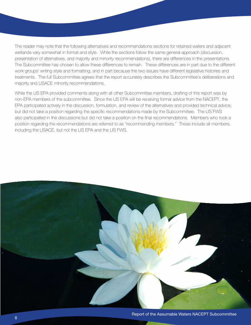
Report of the Assumable Waters NACEPT Subcommittee8
The reader may note that the following alternatives and recommendations sections for retained waters and adjacent wetlands vary somewhat in format and style. While the sections follow the same general approach (discussion, presentation of alternatives, and majority and minority recommendations), there are differences in the presentations. The Subcommittee has chosen to allow these differences to remain. These differences are in part due to the different work groups’ writing style and formatting, and in part because the two issues have different legislative histories and treatments. The full Subcommittee agrees that the report accurately describes the Subcommittee’s deliberations and majority and USACE minority recommendations.
While the US EPA provided comments along with all other Subcommittee members, drafting of this report was by non-EPA members of the subcommittee. Since the US EPA will be receiving formal advice from the NACEPT, the EPA participated actively in the discussion, formulation, and review of the alternatives and provided technical advice, but did not take a position regarding the specific recommendations made by the Subcommittee. The US FWS also participated in the discussions but did not take a position on the final recommendations. Members who took a position regarding the recommendations are referred to as “recommending members.” These include all members, including the USACE, but not the US EPA and the US FWS.
Report of the Assumable Waters NACEPT Subcommittee8
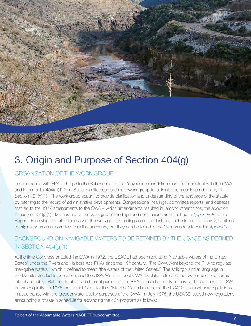
Report of the Assumable Waters NACEPT Subcommittee9
3. Origin and Purpose of Section 404(g) ORGANIZATION OF THE WORK GROUP
In accordance with EPA’s charge to the Subcommittee that “any recommendation must be consistent with the CWA and in particular 404(g)(1),” the Subcommittee established a work group to look into the meaning and history of Section 404(g)(1). The work group sought to provide clarification and understanding of the language of the statute by referring to the record of administrative developments, Congressional hearings, committee reports, and debates that led to the 1977 amendments to the CWA – which amendments resulted in, among other things, the adoption of section 404(g)(1). Memoranda of the work group’s findings and conclusions are attached in Appendix F to this Report. Following is a brief summary of the work group’s findings and conclusions. In the interest of brevity, citations to original sources are omitted from this summary, but they can be found in the Memoranda attached in Appendix F.
BACKGROUND ON NAVIGABLE WATERS TO BE RETAINED BY THE USACE AS DEFINED
IN SECTION 404(g)(1)
At the time Congress enacted the CWA in 1972, the USACE had been regulating “navigable waters of the United States” under the Rivers and Harbors Act (RHA) since the 19th century. The CWA went beyond the RHA to regulate “navigable waters,” which it defined to mean “the waters of the United States.” The strikingly similar language in the two statutes led to confusion, and the USACE’s initial post-CWA regulations treated the two jurisdictional terms interchangeably. But the statutes had different purposes: the RHA focused primarily on navigable capacity; the CWA on water quality. In 1975 the District Court for the District of Columbia ordered the USACE to adopt new regulations in accordance with the broader water quality purposes of the CWA. In July 1975, the USACE issued new regulations announcing a phase-in schedule for expanding the 404 program as follows:
Report of the Assumable Waters NACEPT Subcommittee10
• Phase I: [effective immediately] discharges of dredged material or of fill material into coastal waters and coastal wetlands contiguous or adjacent thereto or into inland navigable waters of the United States and freshwater wetlands contiguous or adjacent thereto are subject to … regulation.
• Phase II: [effective July 1, 1976] discharges of dredged material or of fill material into primary tributaries, freshwater wetlands contiguous or adjacent to primary tributaries, and lakes are subject to … regulation.
• Phase III: [effective after July 1, 1977] discharges of dredged material or of fill material into any navigable water [including intrastate lakes, rivers and streams landward to their ordinary high water mark and up to the headwaters that are used in interstate commerce] are subject to … regulation.
Many in Congress were concerned about the expansion of the USACE’s CWA dredge or fill regulatory program as addressed in their 1975 regulations quoted above, and in 1976 the House of Representatives passed HR 9560 which redefined the CWA term “navigable waters” specifically for the 404 program (but not the rest of the CWA) to:
The term “navigable waters” as used in this section shall mean all waters which are presently used, or are susceptible to use in their natural condition or by reasonable improvement as a means to transport interstate or foreign commerce shoreward to their ordinary high water mark, including all waters which are subject to the ebb and flow of the tide shoreward to their mean high water mark (mean higher high water mark on the west coast).
This House bill was not approved by the Senate and therefore it never became law. The Committee report accompanying the House bill explained that the new definition would be “the same as the definition of navigable waters of the United States as it has evolved over the years through court decisions ... with one exception. [It] omits the historical test of navigability.” The Committee believed “that if a water is not susceptible of use for the transport of interstate or foreign commerce in its present condition or with reasonable improvement,” then it should be excluded from the definition. “Activities addressed by section 404, to the extent they occur in waters other than navigable waters of the United States ... are more appropriately and more effectively subject to regulation by the States.”
Although HR 9560 did not include wetlands in the definition of navigable waters, it protected wetlands by requiring 404 permits for dredged or fill activities in “coastal wetlands and ... those wetlands lying adjacent and contiguous to navigable streams.”
The Senate declined to redefine “navigable waters” for purposes of the 404 program. But the Senate did pass a bill in August 1977 that allowed the states to assume 404 permitting authority, subject to EPA approval, in phase II and III waters (as defined in the USACE’s 1975 regulations quoted above). Until the approval of a state program for Phase II and III waters, the USACE would administer section 404 in all navigable waters. After assumption, the USACE would retain 404 permitting authority in Phase I waters.
The final bill, HR 3199, referred to as the 1977 CWA Amendments, was a compromise. It did not change the definition of “navigable waters” for the 404 program. But it allowed the states to assume permitting authority in “phase II and III waters after the approval of a program by [EPA].”
To effectuate this intent, the final bill inserted the language from HR9560 that had limited the term “navigable waters” into a parenthetical phrase in section 404(g)(1) that defined the waters the USACE must retain. The parenthetical
Report of the Assumable Waters NACEPT Subcommittee11
tracked the language the House Committee had originally used to limit USACE jurisdiction, except that the Conference Committee added “wetlands adjacent thereto” to the parenthetical phrase that defined waters to be retained by the USACE, known as “retained waters.”
The legislative history of 404(g) in both the House and the Senate evidences a Congressional expectation that most States would assume the 404 program, and therefore effectively limit USACE permitting authority to Phase I waters (except waters deemed navigable based solely on historical use, which are assumable by a state). The USACE defined Phase I waters as “navigable waters of the United States” and “wetlands contiguous or adjacent thereto.” The preamble to the USACE’s 1977 regulations described them as “waters already being regulated by the USACE,” i.e., those waters subject to regulation by the USACE under section 10 of the RHA, plus adjacent wetlands.
Numerous judicial opinions over more than a century have factored into the meaning and scope of USACE jurisdiction under the RHA. As the USACE states in its 1977 section 10 regulations, “[p]recise definitions of ‘navigable waters’ or ‘navigability’ are ultimately dependent on judicial interpretation, and cannot be made conclusively by administrative agencies.” Therefore, if and when questions arise in identifying the RHA waters to be retained according to the 404(g)(1) formula at the time a state or tribe assumes permitting authority, agency expertise will be necessary to interpret the RHA standard and apply it on the ground to determine whether a particular feature is assumable or must be retained by the USACE, all of which will be subject to judicial review.
BACKGROUND ON ADJACENT WETLANDS TO BE RETAINED BY THE USACE
When a state or tribe assumes permitting authority, the USACE must retain those waters described above and “wetlands adjacent thereto.”
The phrase “wetlands adjacent thereto” was first added to Section 404(g)(1) by the Conference Committee during the final run-up to enactment of the 1977 amendments, although there had been a reference to wetlands earlier, in HR 9560, which had been passed by the House in the summer of 1976. That bill did not include wetlands in the definition of “navigable waters” but it required permits for discharges to “wetlands lying adjacent and contiguous to navigable streams.” However, neither the House nor the Conference Committee defined what they meant by the terms “adjacent,” “contiguous” or “wetlands.”
While actual definitions of adjacent and wetlands were not included, the terms “contiguous or adjacent wetlands” were used in the USACE’s July 1975 regulations. In July 1977 the USACE for the first time promulgated definitions of “adjacent” and “wetlands” for purposes of its “waters of the United States” regulatory definitions under the CWA. The preamble to the 1977 rule explained that:
“[s]ince ‘contiguous’ is only a subpart of the term ‘adjacent,’ we have eliminated the term ‘contiguous.’ At the same time, we have defined the term ‘adjacent’ to mean ‘bordering, contiguous, or neighboring.’ The term would include wetlands that directly connect to other waters of the United States, or that are in reasonable proximity to these waters but physically separated from them by man-made dikes or barriers, natural river berms, beach dunes, and similar obstructions.”13
13 42 Fed. Reg. 37,122, 37,129 (July 19, 1977).

Report of the Assumable Waters NACEPT Subcommittee12
There are no references in the legislative history of section 404(g) to the USACE’s 1977 definition of “adjacent,” though the regulatory definition quoted above was in place when Congress debated the 1977 amendments. Mention of the meaning of the term “adjacent” came up only once during the final floor debate on the 1977 amendments. In response to questions raised by another Member, Congressman Don H. Clausen, the ranking minority member of the Subcommittee on Water Resources of the House Committee on Public Works and Transportation and one of the drafters of the 1977 CWA amendments, replied that the word “adjacent” as used in 404(g)(1) means “immediately contiguous to the waterway.” Other than this colloquy, there is no significant discussion of what Congress intended by using the word “adjacent” for purposes of allocating permitting authority under 404(g)(1).
In sum, no definitive meaning of the term “adjacent” in 404(g)(1) emerges from a review of the legislative history. Therefore, the meaning of adjacency within 404(g)(1) is susceptible to various interpretations.
Report of the Assumable Waters NACEPT Subcommittee12
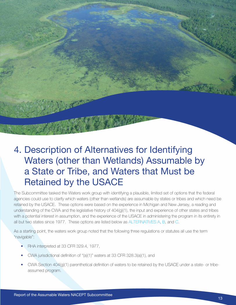
Report of the Assumable Waters NACEPT Subcommittee13
4. Description of Alternatives for Identifying Waters (other than Wetlands) Assumable by a State or Tribe, and Waters that Must be Retained by the USACE
The Subcommittee tasked the Waters work group with identifying a plausible, limited set of options that the federal agencies could use to clarify which waters (other than wetlands) are assumable by states or tribes and which need be retained by the USACE. These options were based on the experience in Michigan and New Jersey, a reading and understanding of the CWA and the legislative history of 404(g)(1), the input and experience of other states and tribes with a potential interest in assumption, and the experience of the USACE in administering the program in its entirety in all but two states since 1977. These options are listed below as ALTERNATIVES A, B, and C.
As a starting point, the waters work group noted that the following three regulations or statutes all use the term “navigable”:
• RHA interpreted at 33 CFR 329.4, 1977,
• CWA jurisdictional definition of “(a)(1)” waters at 33 CFR 328.3(a)(1), and
• CWA Section 404(g)(1) parenthetical definition of waters to be retained by the USACE under a state- or tribe-assumed program.

Report of the Assumable Waters NACEPT Subcommittee14
However, the term “navigable” has different meanings in each of these passages, and the statutes and/or regulations that use “navigable” have different purposes. For example, the purpose of 328.3(a)(1) is to define the scope of jurisdiction under the CWA, while the purpose of 404(g) is to provide for an administrative division of permitting responsibilities between states or tribes and the USACE.
WATERS ALTERNATIVE A: Case-by-case determination of USACE-retained and state- or tribal-assumable waters at the time of program assumption (the status quo).
At the time a state or tribe decides to pursue assumption, the USACE district and the state or tribe will work together to identify, utilizing existing information, which waters will be retained by the USACE and which will be assumed by the state or tribe. Under this alternative, neither EPA nor the USACE would provide further guidance or clarification on criteria to be used to help define the scope of retained vs. assumed waters, but states or tribes would retain their ability to seek assumption within existing processes and procedures. While the Subcommittee deemed it important to put forward this option as one of three, it should be noted that states and tribes have requested that EPA clarify the extent of assumable waters because uncertainty regarding the potential scope of state and tribal permitting authority under an assumed program has proven to be a barrier to full consideration of 404 Program assumption by the states and tribes. This option provides no further clarity due to historic differences and communications in different states, tribes, and districts.
WATERS ALTERNATIVE B: Primary Dependence on RHA Section 10 Lists of Navigable Waters to Define USACE-Retained Waters
This alternative uses existing USACE lists of RHA Section 10 waters to define USACE-retained waters. USACE district offices maintain state-by-state lists of waters that are regulated by the USACE under Section 10 of the RHA for every state except Hawaii. These include waters that are subject to the ebb and flow of the tide and/or are presently used, or have been used in the past, or may be susceptible for use to transport interstate or foreign commerce. This district-maintained list will be used as the basis for the list of USACE-retained waters (List of Retained Waters) for any state or tribe pursuing assumption.
Waters included on the Section 10 lists based solely on historical navigational use may be assumed by a state or tribe,14 and thus would be deleted from a list of USACE-retained waters. All waters of the United States not included on the list of USACE-retained waters would be assumable by a state or tribe.
As discussed earlier in this report in Section 2, subsection on Tribal Considerations Regarding Assumption (see page 3), if a state (as opposed to a tribe) is seeking assumption, waters associated with lands held in trust for federally recognized Indian tribes – that is, that are subject to assumption by a tribe – could also be retained by the USACE unless and until the time of a tribal assumption.
Under ALTERNATIVE B, when a state or tribe initiates the assumption process, the USACE district will use the Section 10 list to develop a List of Retained Waters by (1) deleting waters included on the Section 10 list based on
14 See Appendix F of this report regarding assumption of such waters.

Report of the Assumable Waters NACEPT Subcommittee15
historical use only (applying the relevant factors set forth in the RHA Section 10 regulations); (2) in the case of a state assumption, adding tribal waters, and (3) identifying and adding waters that appropriately belong on the Section 10 list and therefore on the List of Retained Waters.
If the USACE identifies waters that are eligible for but not included on the list of waters regulated under RHA Section 10, either at the time of assumption or following some future alteration in the physical condition of a water body, the USACE can add such waters following consideration of the RHA case law and relevant factors set forth in the RHA Section 10 regulations, including 33 CFR 329.8 (improved or natural conditions of the water body), 329.9(a) (past use), 329.9(b) (future or potential use), and 329.10 (existence of obstructions). Under ALTERNATIVE B, these waters would be retained by the USACE only if they are added to the Section 10 list, unless the determination is based solely on historical use. Once added, these waters would be included in the List of Retained Waters.
The Subcommittee discussed variations within this option at length, but all variations relied on the use of the existing Section 10 lists as the starting point. When a state or tribe seeks assumption, the state or tribe, the USACE, and the EPA would collaborate in review of the existing Section 10 list, clarify the scope of assumable waters, and resolve any waters that do not clearly meet the guidance described in the above paragraph. It is of note that while the state and federal agencies would collaborate in the development of the List of Retained Waters, the USACE would still have sole responsibility for maintaining and adding to the underlying Section 10 list. Inclusion of EPA in these discussions would further assure consideration of state or tribal assumption factors and concerns in devising the List of Retained Waters, including consideration of related issues (e.g., tribal waters). The EPA and the USACE would need to establish a clear dispute resolution procedure to be followed if the state or tribe and the USACE district were not able to complete the List of Retained Waters as part of their MOA development within a reasonable time frame.
WATERS ALTERNATIVE C: Rivers and Harbors Act (RHA) Section 10 Waters plus CWA 33 CFR 328.3(a)(1) Waters as
Retained Waters.
ALTERNATIVE C was proposed by the USACE representative on the Subcommittee and the following explanation of the Alternative has been written by the USACE.
Under this option, retained waters would be determined using both the RHA Section 10 lists, and additional waters determined by the USACE to be Traditional Navigable Waters (TNWs, or (a)(1) waters) under the CWA. In this option, the following process would be used15.
15 The USACE recognizes that there may be Section 10 and/or TNW waters that are not on the existing District lists under paragraphs (i) and (ii). If a state or tribal government asks the USACE for a list of Section 10 waters and TNWs that the USACE does not believe are subject to state CWA Section 404 assumption, the appropriate District office(s) will provide to the state or tribe the existing list of Section 10 waters (minus those based solely on historical use) and TNWs the USACE has available at that time. However, if and when assumption of the Section 404 program is being pursued by a state or tribe, at that time the USACE may be able to provide a more complete and updated list of retained waters, which might differ from the list given initially, and would include the waters resulting from completion of the process outlined in paragraphs (i) and (ii). The USACE recognizes that in many states some waters that have the legal status of Section 10 waters and/or TNWs have not yet been determined by the USACE to have such status. To the extent that available USACE resources allow, the USACE would try to update the list of retained waters for any particular state before the assumption process is finalized by the EPA. For purposes of clarity for the administrative process of state or tribal assumption and in recognition of limited USACE resources to identify all Section 10 and/or TNW waters with such legal status which have not yet been identified within a state, it is practical to limit the list of retained waters by the USACE at the time of final state assumption to those already identified as a Section 10 and/or TNW waters. Nothing in this part diminishes the statutory authorities over waters that may be Section 10 and/or TNWs but have not yet been formally determined as such.
Report of the Assumable Waters NACEPT Subcommittee16
• Include the RHA Section 10 “navigable waters of the US” identified on Section 10 lists developed by the USACE districts within their areas of responsibility. These include waters that are subject to the ebb and flow of the tide and/or are presently used, or have been used in the past, or may be susceptible for use to transport interstate or foreign commerce. For purposes of state or tribal assumption, the list would exclude any waters or reaches of such waters based solely on use in the past.
• Include the Traditional Navigable Waters (TNWs).16,17 For purposes of state or tribal assumption, the list of “navigable waters” that would be retained by the USACE would include any waters for which TNW stand-alone determinations or EPA TNW determinations have been previously made. In addition, case-specific TNW determinations are also made by USACE Districts but are only valid for the specific approved jurisdictional determination for which they are prepared. At the time a state or tribe begins assumption discussions with a USACE District, the District would evaluate all of their completed case-specific TNW determinations to determine whether addition of that water to the retained navigable waters list is warranted under a stand-alone determination. Any CWA (a)(1) TNW18 determination can also serve as precedent for evaluation as a navigable water of the US to be added to the District Section 10 list.
• For purposes of the assumption process, only those waters in paragraphs (i) and (ii) would be retained by the USACE except for the rare exceptions described in paragraph iv below which may occur after a state or tribe has assumed the program under 404(g).
• Post-Assumption: There may be rare occasions when the USACE must make a new or revised Section 10 or TNW determination after it has provided its “retained navigable waters” list to a state or tribe (e.g., when a District independently makes changes to determinations per regulations at 33 CFR 329.14 or under TNW determination guidance, or when a Federal court has made a determination of “navigable waters of the US” or TNW, or when Congress makes a “non-navigable” determination under 33 USC Chapter 1, Subchapter II). In these cases, as with the above option, appropriate adjustments would be made to the retained navigable waters list to account for these revisions. Note that the state or tribe will primarily take on permitting and thereby jurisdictional determinations under their state or tribal programs post-assumption unless and otherwise triggered by these exceptions.
16 See 33 CFR 328.3(a)(1) and Appendix D of the 2007 “US Army Corps of Engineers Jurisdictional Determination Instructional Guidebook” for a definition and guidance on identifying TNWs available at: http://www.usace.army.mil/Portals/2/docs/civilworks/regulatory/cwa_guide/app_d_traditional_navigable_waters.pdf
17 TNWs in this paragraph are only based on the EPA determinations or determinations made under the USACE’s approved jurisdictional determinations and do not include determinations made under a preliminary jurisdictional determination which only indicate which waters “may be” subject to USACE jurisdiction under the USACE’s statutory authorities.
18 The USACE proposes retaining waters that the USACE deems to be “traditional navigable waters” or TNWs under the CWA regulation defining ‘the waters of the United States’ at 33 CFR Section 328.3(a)(1). To avoid confusion with “navigable waters of the United States” regulated under the Rivers and Harbors Act, this report refers to these as “CWA (a)(1) TNWs.”
Report of the Assumable Waters NACEPT Subcommittee17
5. Subcommittee Discussion and Recommendations for Identifying Retained Waters
MAJORITY RECOMMENDATION: WATERS ALTERNATIVE B – Primary Dependence on RHA Section 10 Lists of Navigable Waters to Define USACE Retained Waters
After consideration of various options, all recommending subcommittee members with the exception of the USACE member recommend that EPA adopt and implement policy (guidance and/or regulations) consistent with ALTERNATIVE B to differentiate between assumable waters and those that must be retained by the USACE. The majority of the Subcommittee understands this option to have two primary advantages: clarity, and consistency with CWA Section 404(g)(1) as understood by the majority of Subcommittee members. The following discussion provides reasons for this recommendation as developed by the majority of the Subcommittee, referencing two of the criteria included in the charge to the Subcommittee and identifying a separate third criteria related to Congressional intent based on the legislative history of 404(g). These recommendations are made with the understanding that the Subcommittee is not making any recommendation that would affect the jurisdictional definition of waters of the United States.
Note that none of the Subcommittee members endorsed ALTERNATIVE A – essentially a “no action” alternative – and thus the Subcommittee provides no further discussion of this alternative.

Report of the Assumable Waters NACEPT Subcommittee18
CRITERION 1. Does the recommendation provide clarity and is it easily understood and implementable in the field?
ALTERNATIVE B – the use of Section 10 lists to define USACE retained waters – is practical at the field level, being based on currently available information. It is also reasonably predictable for both the agencies and the public.
The recommended alternative provides a clearly defined set of waters to be retained by the USACE based on an existing administrative tool: the RHA Section 10 lists. This reduces confusion, uncertainty, and prolonged negotiations between a state or tribe and the associated USACE district or districts. Thus, it meets the criterion set forth in the Charge to the Subcommittee.
Lists of RHA Section 10 navigable waters of the United States are maintained by the USACE for all states except Hawaii. Additionally, ALTERNATIVE B recognizes that some RHA Section 10 lists, while generally stable, may not include all Section 10 regulated waters, and that the status of a specific water may change over time (e.g., removal of a dam that renders a stream reach navigable under the RHA). If changes are necessary, agencies can rely on existing regulations to guide the process for modifying the list. This alternative acknowledges that as the USACE and RHA case law amends a state Section 10 list as needed, parallel revisions may be made to the list of USACE-retained waters.
It is not expected that the overall reach of these lists will be modified greatly in the future. Thus, states and tribes can predict with reasonable accuracy which waters would be retained by the USACE in considering whether to pursue an application for Section 404 assumption. Moreover, relying on pre-existing lists (which may be augmented based on existing regulations and RHA case law) will foster efficient assumption procedures and minimize disagreements.
Of equal importance, identification of USACE-retained waters on a list of retained waters in a manner that is generally consistent with RHA Section 10 lists will allow the public to readily determine which agency is responsible for Section 404 regulation at a specific location under a state or tribal assumed program. The Section 10 lists are well established, and can be relatively easily labeled on regional maps or GIS systems, and therefore the Lists of Retained Waters would similarly be easily labeled. As noted in the discussion of the alternatives, the one complexity in utilizing the RHA Section 10 list for state or tribal assumption is those RHA Section 10 listed waters that may be based solely on historical use and would not be retained by the USACE.
By contrast, ALTERNATIVE C could result in uncertainty at the statewide and field level regarding the scope of state- or tribal-assumable versus USACE-retained waters, both before and after state or tribal program assumption. Under ALTERNATIVE C, the USACE would retain both RHA Section 10 waters and CWA “traditional navigable waters” under the USACE’s jurisdictional regulations at 33 CFR 328.3(a)(1). As compared to ALTERNATIVE B, which relies on the clear definition of RHA waters, ALTERNATIVE C depends on multiple regulations, guidance, and procedures, and ties the identification of retained waters to determining the extent of CWA (a)(1) TNWs – waters that are less clearly defined than Section 10 waters.
Whereas the majority of RHA Section 10 waters are identified on lists maintained by each USACE district, the location and extent of CWA (a)(1) TNWs that would be retained by the USACE in the case of assumption are identified through a number of different approaches. The USACE and EPA have made some “stand-alone” CWA (a)(1) TNW determinations, and the USACE districts have documented some of these. These stand-alone determinations would be included in the list of retained waters under ALTERNATIVE C. The USACE also issues approved jurisdictional

Report of the Assumable Waters NACEPT Subcommittee19
determinations when they are requested by landowners or other interested parties. Many of these case-by-case jurisdictional determinations issued after the Supreme Court decision in Rapanos v. United States, 547 US 715 (2006) identify the nearest CWA (a)(1) TNW, but these “case-by-case” determinations are not considered permanent.
Because most TNWs have not yet been identified as such and thus lists of stand-alone TNWs could increase, ALTERNATIVE B provides more clarity, certainty and predictability to states, tribes and the regulated community regarding the scope of the state or tribal program.
After state or tribal program assumption, the USACE proposes to cease routine jurisdictional determinations in assumed waters but ALTERNATIVE C notes that additional waters might still be identified as CWA (a)(1) TNW waters in association with various legal proceedings, including federal enforcement actions. These CWA (a)(1) TNWs identified after assumption would be added to the List of Retained Waters at the time they are identified.
CRITERION 2. Is the recommendation consistent with the CWA, and with Section 404(g)?
ALTERNATIVE B is consistent with CWA Section 404(g) based on the plain language of Section 404(g) and the legislative history. Congress clearly intended that states and tribes should play a significant role in the administration of Section 404 – as they do in other CWA programs – anticipating that many states would assume the Section 404 program.
Congress also recognized the long-standing role and expertise of the USACE in maintaining navigation under the RHA, and therefore specified that the USACE would retain the parallel 404 permitting authority in those RHA waters and adjacent wetlands even after a state or tribe assumed 404 permitting authority over remaining waters and wetlands. Congress relied on RHA Section 10 to identify USACE-retained waters, with one exception: waters that were deemed “navigable” for RHA purposes based solely on historical practices (e.g., waters capable of carrying canoes for fur- trading in the 18th century) are also assumable by states or tribes.
On the other hand, all Subcommittee members except the USACE member believe that ALTERNATIVE C – under which the USACE would retain both RHA Section 10 waters and CWA (a)(1) TNWs identified up to the date of assumption – is not consistent with CWA Section 404(g), based upon its plain language and the legislative history. Congress was specific about what it intended in 404(g):
“The Committee amendment does not redefine navigable waters. Instead the committee amendment intends to assure continued protection for all of the Nation’s waters, but allows States to assume primary responsibility for protecting those lakes, rivers, streams, swamps, marshes and other portions of the navigable waters outside the USACE program in the so-called Phase I waters.”19
The USACE’s 1977 regulations reinforced that understanding. The preamble characterized Phase I as covering “waters already being regulated by the USACE [i.e. RHA waters] plus all adjacent wetlands to these waters.”
19 Clean Water Act of 1977 Report of the Committee on Environment and Public Works, United States Senate, July 1977, pg. 75

Report of the Assumable Waters NACEPT Subcommittee20
The USACE definition of “navigable waters of the United States” under the RHA is similar to the definition of waters to be retained by the USACE under Section 404(g)(1) – except for the deletion of historically used waters and addition of adjacent wetlands.
Section 10 regulations, 33 CFR section 329.4: “Navigable waters of the United States are those waters that are subject to the ebb and flow of the tide and/or are presently used, or have been used in the past, or may be susceptible to use to transport interstate or foreign commerce.”
Section 404(g)(1) description of waters to be retained by the USACE: “ ... waters that are presently used, or are susceptible to use in their natural condition or by reasonable improvement as a means to transport interstate and foreign commerce ... including wetlands adjacent thereto.”
This similarity leads the majority of Subcommittee members to again conclude that the “navigable waters” to be retained by the USACE were intended to be the same waters regulated by the RHA. Further, the USACE regulation indicates that, “This definition does not apply to authorities under the Clean Water Act, which definitions are described at 33 CFR parts 323 and 328.”20
Moreover, the majority of the Subcommittee also understands the USACE to have acknowledged during Subcommittee discussions that the USACE can and does distinguish between Section 10 waters and CWA (a)(1) waters for regulatory purposes, displaying maps showing the two different categories in two states where USACE districts have identified Section 10 and CWA TNW waters. The Nationwide Permits issued by the USACE on January 6, 2017 also repeatedly distinguish between RHA waters and CWA waters, suggesting that such a distinction is and can be made with relative ease. Therefore, the majority of the Subcommittee holds that distinguishing between Section 10 and CWA (a)(1) waters for the purpose of distinguishing between assumable and USACE-retained waters remains practical and appropriate in accordance with 404(g).
CRITERION 3. Does the Recommendation comport with Congressional intent that qualified states assume responsibility for the Section 404 regulatory program?
The Subcommittee majority views that ALTERNATIVE B makes it easier for states and tribes to understand the costs associated with assumption and thus more readily weigh the costs and benefits of assuming the program, thereby encouraging state or tribal assumption, if desired, consistent with Congressional intent and with other CWA programs.
States and tribes may be willing to undertake Section 404 program assumption for the reasons discussed earlier in this report, but they do incur the cost of development and administration of a state or tribal 404 program. Assumption of all CWA waters except those on the RHA Section 10 list minus solely historical use – as has occurred in Michigan and New Jersey – would provide an economy of scale to the state and the public, which could make the development and ongoing fixed costs more acceptable for qualified states or tribes who wish to pursue this approach under the CWA.
ALTERNATIVE C would be an effective barrier to assumption for many if not most states and tribes. The impact of ALTERNATIVE C would vary geographically, but particularly in states with significant wetlands and other water resources, the USACE could retain a greater percentage of waters (and adjacent wetlands) under this option. As
20 33 CFR §329.1.
Report of the Assumable Waters NACEPT Subcommittee21
an example, during Subcommittee discussions the USACE representatives presented a graphic map prepared by the Kansas City District that compared CWA (a)(1) waters to RHA Section 10 waters in the district. RHA Section 10 waters in the district totaled 887 stream miles; the addition of CWA (a)(1) waters tripled this to 2476 stream miles. The extent of adjacent wetlands would be expected to increase proportionally.
Many waters identified as “TNWs” under CWA jurisdictional guidance21, such as inland lakes, have an impact on interstate commerce resulting from tourism, but may have little to no impact on the transport of interstate or foreign commerce (as do RHA waters). Examples of determinations made under this jurisdictional federal guidance include Bah Lake (an isolated 70-acre water, maximum depth 10 feet) and Boyer Lake (300-acre 28-feet maximum depth) – both of which are defined as CWA (a)(1) TNWs. Such water bodies are common on the American landscape. While the scale might be different in different states it is clear that there are more CWA (a)(1) TNW waters, and more scattered across the landscape, than are RHA waters. The net effect is that the scope and location of CWA (a)(1) TNW waters are such that having the USACE retain these waters could undermine Congress’s intent that the states assume authority over most of the waters within their borders.
Finally, it should be noted that states and tribes have operated for many years under the belief that if they develop a comprehensive wetland/dredge and fill permitting program consistent with federal statute and regulations, they will be eligible to assume that program for all but Section 10 waters (and adjacent wetlands). In order to protect state waters, many states have developed wetland assessment and monitoring programs, wetlands water quality standards, and regulatory processes that would eventually help to provide eligibility for full Section 404 assumption should they choose to pursue that option. ALTERNATIVE C could decrease the value of that investment.
USACE RECOMMENDATION: WATERS ALTERNATIVE C – Section 10 waters plus CWA (a)(1) Waters as Retained Waters.
While the USACE is neutral with respect to state or tribal assumption of Section 404 of the CWA program, the USACE does believe there are valid considerations that must be factored into the determination of which waters must be retained (and ultimately which waters can be assumed by a state or tribe). The USACE believes there should not be a distinction between different uses of the term “navigable waters” under different sections of the statute, and believes this is consistent with the purposes of the CWA and Section 404(g). While the statutory language setting forth the CWA Section 404(g) parenthetical waters slightly differs from the regulatory language of 328.3(a)(1), the USACE believes the interpretation of the term “navigable waters” is the same under 404(g) and 328.3(a)(1) (other than those waters considered navigable based solely on their historic use). The USACE believes TNWs reflect the concept of “navigability” appropriate to ensure the objective of the CWA to restore and maintain the chemical, physical, and biological integrity of the Nation’s waters (see “Appendix D: Legal Definition of ‘Traditional Navigable Waters’”22). The USACE has maintained this position since at least the 2008 post-Rapanos guidance was issued and it is not a “new” position created by the agency for purposes of this subcommittee.
21 Appendix D of the 2007 “US Army Corps of Engineers Jurisdictional Determination Instructional Guidebook” available at: http://www.usace.army.mil/Portals/2/docs/civilworks/regulatory/cwa_guide/app_d_traditional_navigable_waters.pdf
22 Ibid.
Report of the Assumable Waters NACEPT Subcommittee22
A narrower reading of those waters retained by the USACE under the state assumption program would not take into consideration the evolution of the USACE Regulatory Program since 1977. The USACE must continue to modify its program to reflect changes in law, policy, science, and other considerations, including changes in what waters constitute waters of the US under the CWA.
Different definitions for the term “navigable waters” under different provisions of the same statute could also result in confusion that would not provide clarity for the regulated public. The states and tribes would know the Section 10 waters (as identified by the District lists) as well as the stand-alone TNW determinations made by the Districts. All approved jurisdictional determinations made by the USACE are posted on District websites and are publicly available. Thus, the case-specific TNW determinations that may be included on the retained waters list when the state initiates that process are also available. In conclusion, these lists and waters are known and publicly available and therefore provide clarity to the USACE, the state, and the regulated public.
Report of the Assumable Waters NACEPT Subcommittee22
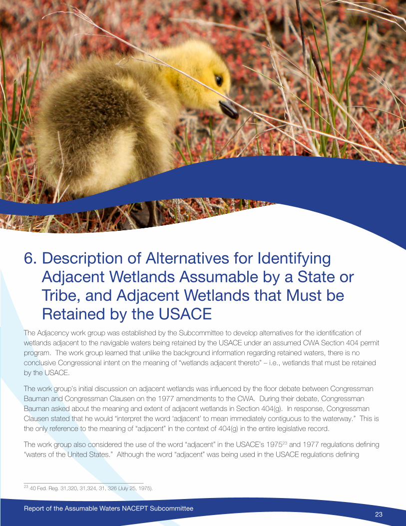
Report of the Assumable Waters NACEPT Subcommittee23
6. Description of Alternatives for Identifying Adjacent Wetlands Assumable by a State or Tribe, and Adjacent Wetlands that Must be Retained by the USACE
The Adjacency work group was established by the Subcommittee to develop alternatives for the identification of wetlands adjacent to the navigable waters being retained by the USACE under an assumed CWA Section 404 permit program. The work group learned that unlike the background information regarding retained waters, there is no conclusive Congressional intent on the meaning of “wetlands adjacent thereto” – i.e., wetlands that must be retained by the USACE.
The work group’s initial discussion on adjacent wetlands was influenced by the floor debate between Congressman Bauman and Congressman Clausen on the 1977 amendments to the CWA. During their debate, Congressman Bauman asked about the meaning and extent of adjacent wetlands in Section 404(g). In response, Congressman Clausen stated that he would “interpret the word ‘adjacent’ to mean immediately contiguous to the waterway.” This is the only reference to the meaning of “adjacent” in the context of 404(g) in the entire legislative record.
The work group also considered the use of the word “adjacent” in the USACE’s 197523 and 1977 regulations defining “waters of the United States.” Although the word “adjacent” was being used in the USACE regulations defining
23 40 Fed. Reg. 31,320, 31,324, 31, 326 (July 25, 1975).
Report of the Assumable Waters NACEPT Subcommittee24
“waters of the United States” just prior to the 1977 CWA amendments, there are no references to the USACE regulations in the legislation or Committee reports. In addition, the regulatory definition of adjacency was established after the original statutory language, but before final passage, of the 1977 amendments. Because of the timing of the various actions, the Subcommittee could not assume that Congress was aware of the USACE regulatory definition when this section of the statute was written. For most subcommittee members, it is clear, however, that the word “adjacent” in 404(g) was referring to adjacency to RHA waters, which were being retained primarily to foster federal navigation interests. Therefore, while the meaning of adjacent in 404(g) is not certain, the majority of the Subcommittee believes the purpose of adjacent in 404(g) is different than the jurisdictional definition in the USACE “waters of the United States” regulations. “Adjacent” is used in Section 404(g) to allocate permitting responsibilities between the USACE and a state or tribe that is assuming the 404 program, whereas “adjacent” is used in the USACE “waters of the United States” regulations to define the scope of jurisdiction under the CWA. Agencies generally have discretion in making judgments on how to administer their programs, and thus should have some discretion in how they define what is adjacent for purposes of allocating administrative authority between states or tribes and the USACE.
WETLANDS ALTERNATIVE A: USACE Retains All Wetlands Whether Touching or Not Touching Retained Navigable Waters, Regardless of Furthest Reach
WETLANDS ALTERNATIVE A interprets the word “adjacent” in 404(g) to mean the same as the word “adjacent” in regulations24 currently being used by the USACE to identify jurisdictional “adjacent” wetlands. Under WETLANDS ALTERNATIVE A, the USACE would retain permitting authority over all wetlands adjacent to retained navigable waters whether or not they are touching retained navigable waters and regardless of their extent (see Figure 1: WETLANDS ALTERNATIVE A).
ALTERNATIVE A would require that the USACE retain expansive wetland systems that are touching a retained water, regardless of their extent. Thus, the specific extent of retained wetlands could not be determined at the time of program assumption and the majority of projects would require a case-by-case field inspection to determine whether the USACE would retain permitting authority.
24 33 CFR S328.3(c). (“The term adjacent means bordering, contiguous, or neighboring. Wetlands separated from other waters of the United States by man-made dikes or barriers, natural river berms beach dunes and the like are ‘adjacent wetlands’.”
Figure 1. WETLANDS ALTERNATIVE A

Report of the Assumable Waters NACEPT Subcommittee25
WETLANDS ALTERNATIVE B: USACE Retains Entirety of Wetlands Touching Retained Waters, Regardless of Furthest Reach
WETLANDS ALTERNATIVE B also relies on the current definition of “adjacent” in the regulations that define “waters of the United States,” but under this alternative, the USACE would not retain all “adjacent” wetlands. Rather, it would only retain permitting authority over wetlands touching the waters being retained by the USACE.
As discussed in the Origin and Purpose of Section 404(g) section of this report, above, Congress intended that in a case of state or tribal assumption the USACE would retain permitting authority over “Phase I waters” (except waters deemed navigable based solely on historical use, which would be assumable by a state or tribe). Phase I waters were defined in the USACE’s 1975 regulations as coastal and inland “navigable waters of the United States” and wetlands “contiguous or adjacent thereto” – i.e., waters subject to regulation by the USACE under Section 10 of the RHA, plus adjacent wetlands. The RHA is designed to protect the navigable capacity of the “navigable waters of the US” and thus requires permits for work in “navigable waters of the US” and work outside “navigable waters of the US ... if these structures or work affect the course, location, or condition of the waterbody in such a manner as to impact on its navigable capacity.” WETLANDS ALTERNATIVE B assumes that wetlands touching retained waters have the greatest ability to impact navigability under Section 10 of the RHA and that wetlands not affecting navigability can be assumed by a state or tribe for administrative purposes under the CWA. As a result, wetlands that are “not touching” retained waters could be assumed by a state or tribe (see Figure 2: WETLANDS ALTERNATIVE B).
Like WETLANDS ALTERNATIVE A, WETLANDS ALTERNATIVE B would require that the USACE retain expansive wetland systems that are touching a retained water, regardless of their extent. Also similar to WETLANDS ALTERNATIVE A, the specific extent of retained wetlands could not be determined at the time of program assumption and the majority of projects would require a case-by-case field inspection to determine whether the USACE would retain permitting authority.
WETLANDS ALTERNATIVE C:
Establishment of a National Administrative Boundary
WETLANDS ALTERNATIVE C requires the establishment of a national administrative boundary based on a fixed distance from USACE-retained navigable waters (e.g., 100, 300, or 1,000 feet). The boundary would depict the limits of federal program administration and the beginning of state or tribal program administration under an assumed CWA Section 404 permit program.
The establishment of a national administrative boundary to assign regulatory responsibility over adjacent wetlands should build on USACE authorities under the RHA. The RHA was enacted primarily to protect navigation and the
Figure 2. WETLANDS ALTERNATIVE B
Report of the Assumable Waters NACEPT Subcommittee26
navigable capacity of the nation’s waters. Section 10 of the RHA requires that the following regulated activities be approved or permitted by the USACE: placement and removal of structures; work involving dredging; disposal of dredged material; filling, excavation, or any other disturbance of soils or sediments; or modification of a navigable waterway. All of these activities have the potential to affect navigability, further underscoring that the RHA’s primary purpose is to protect navigable capacity. Depicting adjacent wetlands retained by the USACE as an administrative distance from retained waters based on existing state-established setbacks, buffers, or a defined elevation as in the case of New Jersey, or other criteria, preserves the USACE’s control over waters and wetlands necessary to protect these waters from activities that may adversely impact navigability.
In general, the activities taking place landward of the “ordinary high water mark” (inland) or “mean high water mark” (coastal) that potentially impact navigation and warrant continued regulation by the USACE under an assumed program are those that are likely to generate sediment and debris that reach channels and harbors and affect the navigable capacity of waters used to transport interstate or foreign commerce. Consequently, activities taking place in wetlands adjacent to navigable waters may warrant regulation by the USACE either under the CWA, the RHA, or both. Regulated activities that may impact navigable capacity, however, would likely occur in areas that are in close proximity to the waterways retained by the USACE. Riparian buffers and setbacks are established by many states to, among other purposes, help store floodwaters and prevent sediment transport, directly supporting and preserving navigation. Thus, such state-established boundaries can provide both a practical and a logical basis for the establishment of a national administrative boundary between wetlands retained by the USACE and wetlands assumed by a state or tribe.
The establishment of a national administrative boundary would resolve a number of adjacency issues. The use of an administrative line to assign regulatory responsibility for the implementation of the CWA ensures complete protection of water and wetland resources without confusion or unnecessary duplication, while preserving the USACE’s responsibility to protect and maintain navigation under the RHA as required by Congress. Since the boundary defines the landward extent of the adjacent wetlands retained by the USACE, it eliminates the need to determine the extent and connectivity of large wetland systems to allocate administrative authority between the USACE and a state or tribe. The boundary would be established prior to program assumption and incorporated into GIS or other mapping methods to facilitate a state or tribe’s assessment of the costs and benefits of assumption. Finally, because WETLANDS ALTERNATIVE C establishes a bright line boundary, the entirety of expansive wetland systems such as those in examples from Alaska, Minnesota, and the Fond du Lac Reservation would not be retained by the USACE. Thus, more wetlands would be assumable than would be the case under other alternatives.
Based on the above discussion, the Subcommittee agreed that a default distance of 300 feet from the retained navigable water would be fully adequate to protect federal navigation interests and could serve as a reasonable national administrative boundary. The Subcommittee identified several possible implementation strategies once this national administrative boundary is established, which are presented below.
WETLANDS ALTERNATIVE C1: USACE Retains All Wetlands Touching Retained Navigable Waters and Extending Landward to the National Administrative Boundary
Under WETLANDS ALTERNATIVE C1, the USACE would retain permitting authority over all wetlands physically “touching” retained navigable waters and extending landward to the national administrative boundary. The state or tribe would assume those wetlands beyond the established boundary. Additionally, wetlands that are shoreward of

Report of the Assumable Waters NACEPT Subcommittee27
the administrative boundary but not “touching” a retained navigable water would be assumed by the state or tribe (see Figure 3: WETLANDS ALTERNATIVE C1).
While the administrative boundary would clearly define the extent of USACE retention for large or expansive wetlands, many projects would still require a case-by-case field inspection to determine whether the affected wetland is in fact touching the retained water. This alternative would likely result in the greatest amount of wetlands assumable by a state or tribe, but contains some implementation inefficiencies similar to WETLANDS ALTERNATIVES A and B due to the need for case-by-case field inspections on many projects. For instance, physical separations, such as river berms or beach dunes are dynamic, meaning that this alternative would result in an equally dynamic “sometimes in or sometimes out” scenario that is not conducive to predictability for the public.
WETLANDS ALTERNATIVE C2: USACE Retains All Adjacent Wetlands Between Retained Waters and the National Administrative Boundary
Under WETLANDS ALTERNATIVE C2, the USACE retains permitting authority over all wetlands adjacent to retained navigable waters up to the national administrative boundary. The state or tribe would only assume those wetlands beyond the national administrative boundary (see Figure 4: WETLANDS ALTERNATIVE C2).
Under this alternative, there is no need for case-by-case field investigations to determine the extent and connectivity of large or expansive wetland systems. The partitioning of administrative authority under Section 404 assumption would be completely separate from issues relating to determining Section 404 jurisdiction, and the farthest reach of all retained wetlands would be known prior to program assumption. WETLANDS ALTERNATIVE C2 provides substantial clarity and certainty for states, tribes, the USACE, and the regulated public.
WETLANDS ALTERNATIVE C3: USACE Retains All Wetlands Landward to an Administrative Boundary Established During the Development of the Memorandum of Agreement with the USACE, with a 300-foot National Administrative Boundary as a Default
WETLANDS ALTERNATIVE C3 establishes a 300-foot national administrative boundary up to which the USACE retains permitting authority over all wetlands regardless of whether they are touching retained navigable waters. However, under this alternative, that boundary could shift in accordance with negotiations between a state or tribe and the
Figure 3. WETLANDS ALTERNATIVE C1
Figure 4. WETLANDS ALTERNATIVE C2
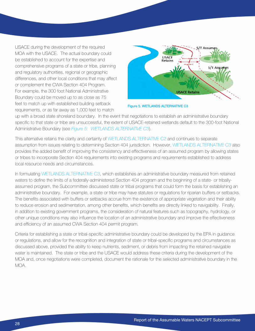
Report of the Assumable Waters NACEPT Subcommittee28
USACE during the development of the required MOA with the USACE. The actual boundary could be established to account for the expertise and comprehensive programs of a state or tribe, planning and regulatory authorities, regional or geographic differences, and other local conditions that may affect or complement the CWA Section 404 Program. For example, the 300 foot National Administrative Boundary could be moved up to as close as 75 feet to match up with established building setback requirements, or as far away as 1,000 feet to match up with a broad state shoreland boundary. In the event that negotiations to establish an administrative boundary specific to that state or tribe are unsuccessful, the extent of USACE-retained wetlands default to the 300-foot National Administrative Boundary (see Figure 5: WETLANDS ALTERNATIVE C3).
This alternative retains the clarity and certainty of WETLANDS ALTERNATIVE C2 and continues to separate assumption from issues relating to determining Section 404 jurisdiction. However, WETLANDS ALTERNATIVE C3 also provides the added benefit of improving the consistency and effectiveness of an assumed program by allowing states or tribes to incorporate Section 404 requirements into existing programs and requirements established to address local resource needs and circumstances.
In formulating WETLANDS ALTERNATIVE C3, which establishes an administrative boundary measured from retained waters to define the limits of a federally-administered Section 404 program and the beginning of a state- or tribally-assumed program, the Subcommittee discussed state or tribal programs that could form the basis for establishing an administrative boundary. For example, a state or tribe may have statutes or regulations for riparian buffers or setbacks. The benefits associated with buffers or setbacks accrue from the existence of appropriate vegetation and their ability to reduce erosion and sedimentation, among other benefits, which benefits are directly linked to navigability. Finally, in addition to existing government programs, the consideration of natural features such as topography, hydrology, or other unique conditions may also influence the location of an administrative boundary and improve the effectiveness and efficiency of an assumed CWA Section 404 permit program.
Criteria for establishing a state or tribal-specific administrative boundary could be developed by the EPA in guidance or regulations, and allow for the recognition and integration of state or tribal-specific programs and circumstances as discussed above, provided the ability to keep nutrients, sediment, or debris from impacting the retained navigable water is maintained. The state or tribe and the USACE would address these criteria during the development of the MOA and, once negotiations were completed, document the rationale for the selected administrative boundary in the MOA.
Figure 5. WETLANDS ALTERNATIVE C3
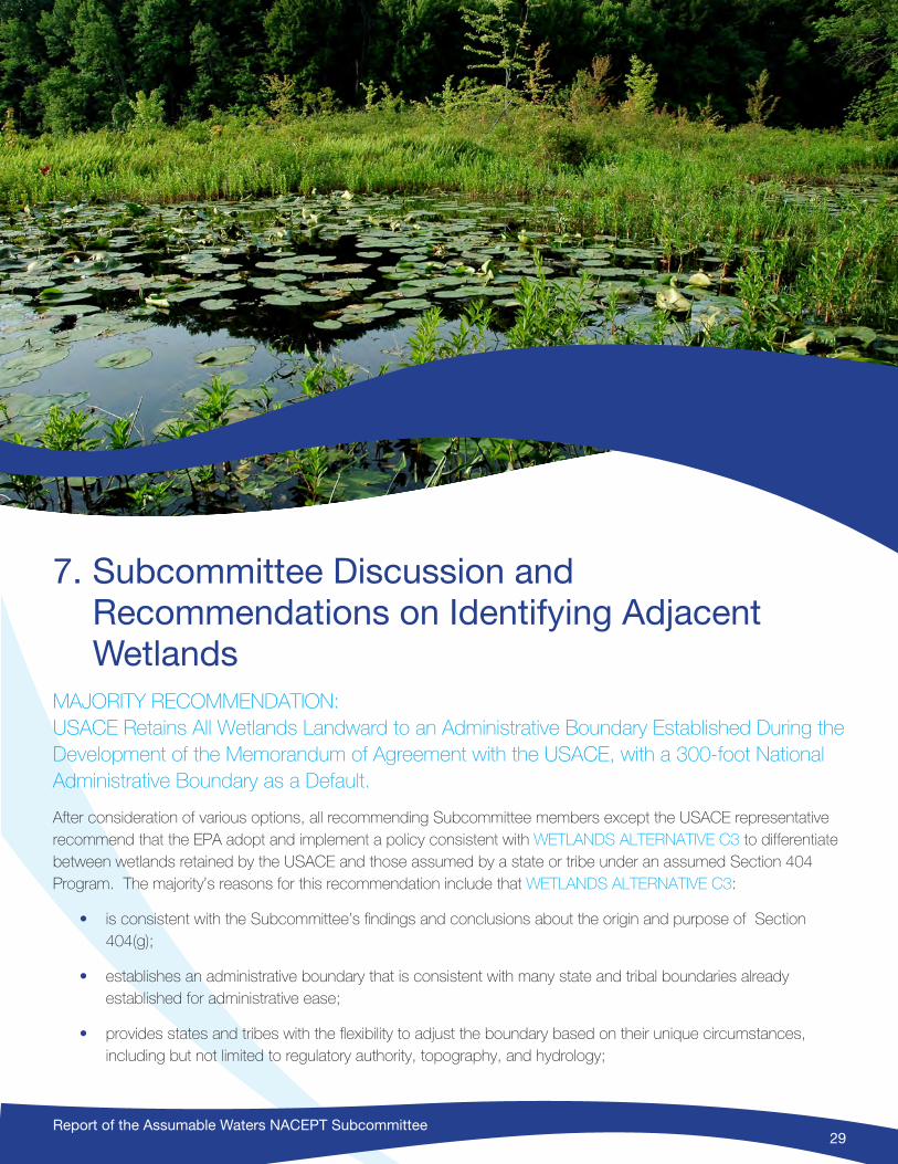
Report of the Assumable Waters NACEPT Subcommittee29
7. Subcommittee Discussion and Recommendations on Identifying Adjacent Wetlands
MAJORITY RECOMMENDATION: USACE Retains All Wetlands Landward to an Administrative Boundary Established During the Development of the Memorandum of Agreement with the USACE, with a 300-foot National Administrative Boundary as a Default.
After consideration of various options, all recommending Subcommittee members except the USACE representative recommend that the EPA adopt and implement a policy consistent with WETLANDS ALTERNATIVE C3 to differentiate between wetlands retained by the USACE and those assumed by a state or tribe under an assumed Section 404 Program. The majority’s reasons for this recommendation include that WETLANDS ALTERNATIVE C3:
• is consistent with the Subcommittee’s findings and conclusions about the origin and purpose of Section 404(g);
• establishes an administrative boundary that is consistent with many state and tribal boundaries already established for administrative ease;
• provides states and tribes with the flexibility to adjust the boundary based on their unique circumstances, including but not limited to regulatory authority, topography, and hydrology;
Report of the Assumable Waters NACEPT Subcommittee30
• assures that the USACE is able to maintain navigability as required by the Rivers and Harbors Act;
• allows for the identification and mapping of the administrative boundary prior to program assumption, providing clarity, understanding, and after assumption, ease of implementation;
• uses a process to determine the extent of retained wetlands that is easily distinguished from the process used to determine Section 404 jurisdiction, resulting in improved efficiency, regulatory certainty, and sufficient wetland resources for a state or tribe to assume;
• provides a clear, reasonable, and implementable separation of administrative authority by establishing a clearly demarcated boundary between USACE-retained and state or tribally-assumed wetland areas; and
• maximizes the efficiency and effectiveness of assumed programs by allowing them to be tailored to a state’s or tribe’s specific circumstances.
Discussion on the justification and rationale for WETLANDS ALTERNATIVE C3 follows, including comparisons to other alternatives when appropriate based on criteria developed by the Adjacency work group.
CRITERION #1: WETLANDS ALTERNATIVE C3 is consistent with Section 404(g) of the CWA.
Congress passed 404(g) with the expressed intention that states and tribes would play a significant role in the administration of the Section 404 program. The purpose of section 404(g)(1) is to identify those waters and wetlands that must be retained by the USACE. The legislative history also indicates that the purpose of retention by the USACE is related to RHA Section 10 authorities primarily to maintain navigability and related interests.
WETLANDS ALTERNATIVE C3 is consistent with Congressional intent because it provides clarity on the wetlands for a state or tribe may assume, thereby removing one of the current barriers to assumption. WETLANDS ALTERNATIVE C3 is also consistent with Congressional intent because it establishes an administrative boundary that will ensure that the USACE can protect and maintain navigability and water quality in retained waters.
The unique state-assumed section 404 program administered by New Jersey since 1994 has clearly demonstrated that a state-specific administrative boundary, different from a CWA jurisdictional boundary, is both implementable and consistent with Section 404(g)(1). WETLANDS ALTERNATIVE C3 allows for the establishment of other assumed programs with state-specific or tribal-specific administrative boundaries.
CRITERION #2: WETLANDS ALTERNATIVE C3 provides a clear, reasonable, and implementable separation of administrative authority.
The stated charge of the Assumable Waters Subcommittee is to provide advice and recommendations on how to best clarify which waters a state or tribe can assume under an EPA-approved CWA Section 404 program. WETLANDS ALTERNATIVE C3, by establishing a “bright line” administrative boundary, provides needed clarity. The public, states, tribes, and federal agencies can easily identify the appropriate permitting authority at the time an application is submitted.
WETLANDS ALTERNATIVE A (USACE Retains All Wetlands, Whether Touching or Not Touching Retained Navigable Waters, Regardless of Furthest Reach) and WETLANDS ALTERNATIVE B (USACE retains entirety of wetlands touching
Report of the Assumable Waters NACEPT Subcommittee31
retained waters, regardless of further reach) would result in four problem scenarios. First, large wetland complexes can extend tens or even hundreds of miles from the retained water. Examples provided by the states of Alaska and Minnesota demonstrate that using the regulatory CWA jurisdictional definition of adjacency to describe retained wetlands would result in expansive wetland systems being retained by the USACE, leaving fewer wetlands to be assumed by a state or tribe.
Second, wetlands often extend away from navigable waters in intricate and snakelike networks, which could result in a confusing pattern of USACE and state or tribal permitting authority across the landscape. For example, the St. Louis River (a tributary to Lake Superior) forms some of the boundaries of the Fond du Lac Indian Reservation in Minnesota where wetlands comprise 44% of the Reservation. Wetlands adjacent to the St. Louis River, which has been determined to be a navigable water, are interconnected with other wetlands that extend tens of miles away from the river, well beyond other wetlands that are not connected or adjacent to the river.
Third, wetlands adjacent to USACE-retained waters can extend beyond state-assumed waters. For example, the USACE retains a stream with the exception of the upstream portion of it that is beyond the point of navigability (or “head of navigation”), but wetlands adjacent to the retained portion of the stream continue to extend farther up the watershed (a common occurrence, particularly in upstream reaches). Absent some administrative demarcation of which adjacent wetlands would be retained, an awkward situation results where a state or tribe assumes an upstream section of a stream, but the USACE retains its adjacent wetlands.
Fourth, scenarios that require case-by-case field inspections to determine the appropriate regulating authority will reduce the efficiencies of an assumed program.
Prior to assumption, the problems associated with WETLANDS ALTERNATIVES A and B would make it difficult for states or tribes to accurately assess the feasibility and benefits of assumption because the extent of retained wetlands would be unknown or unclear. Lacking a known boundary for retained wetlands, it would require a significant upfront investment for a state or tribe to make an informed decision about pursuing assumption of the 404 program and accurately planning for its development. In the event that a state or tribe assumed the program without having ascertained the boundary, the problem scenarios discussed above would essentially make it more difficult for the state or tribe to deliver on the stakeholder efficiencies anticipated under an assumed Section 404 permit program such as ease of determining administrative control, speed of reaching a permit decision, and other customer service improvements. Use of WETLANDS ALTERNATIVE C3 would eliminate these problems by establishing a standard national boundary.
CRITERION #3: WETLANDS ALTERNATIVE C3 establishes an administrative boundary that can be consistent with already established state or tribal program boundaries.
Many states and tribes have already established various boundaries, lines, or demarcations in their state or tribal programs. For administrative ease, these established lines can be used to establish the administrative line for retained and assumable waters. Such an administrative boundary will assure that the USACE is able to maintain navigability as required by RHA waterward of the boundary, while the state or tribe assumes authority to protect wetlands and water quality as required by the CWA landward of the boundary.
Report of the Assumable Waters NACEPT Subcommittee32
CRITERION #4: WETLANDS ALTERNATIVE C3 provides flexibility to maximize the efficiency and effectiveness of a State- or Tribally-assumed 404 program.
In WETLANDS ALTERNATIVE C3, under prescriptive guidance or regulations that establish a default administrative boundary (i.e., 300 feet from retained navigable water), states and tribes can still further negotiate the location of the administrative boundary with the USACE during the establishment of the relevant MOA (for example, 75 or 1,000 feet). Unlike WETLANDS ALTERNATIVES C1 and C2, WETLAND ALTERNATIVE C3 allows the parties to establish a boundary taking into account other existing regulatory programs or requirements and the unique landscape characteristics of the state or tribal territory. This could lead to better environmental results, administrative efficiency, clarity for the public and regulators, and a strengthening of the aligned state or tribal program.
WETLANDS ALTERNATIVE C3 also provides states and tribes with the ability to tailor the line to features specific to the state or tribe. In such a large geographically and biologically diverse nation, there are significant differences in landscapes and the nature of our waters and wetlands among the states. WETLANDS ALTERNATIVE C3 allows USACE and the state or tribe to address these regional resource differences and provide an opportunity to utilize the best available information, tools, and procedures. For example, the distance used to establish the administrative boundary could vary based on unique floodplain characteristics of a given waterbody. Focusing on up-front mapping may even encourage the development of improved, more comprehensive inventories and cartography.
CRITERION #5: Under WETLANDS ALTERNATIVE C3, the administrative boundary for retained wetlands can be identified and mapped prior to program assumption, providing clarity, understanding, and ease of implementation.
In many cases, the state or tribe would assert continuous permitting authority over all waters and wetlands regardless of whether the USACE also regulates those waters and wetlands. In other cases, a state or tribe may choose to minimize or eliminate permitting duplication entirely and not require a permit for projects permitted by the USACE (i.e., exempt landowners from state or tribal permitting requirements). While in either case, the extent of retained waters and wetlands must be identified, in those instances where a state or tribe exempts federally regulated activities, it is even more important for landowners to know the permitting authority before submitting a permit application (i.e., know the boundary and extent of retained wetlands) because the application will go to either the state, tribe or the USACE. WETLANDS ALTERNATIVE C3 provides a relatively simple and consistent mechanism for identifying the clear boundary of retained wetlands.
The extent of the wetlands retained by the USACE under WETLANDS ALTERNATIVES A and B is not limited by distance. This could make identifying and mapping assumable waters extremely challenging. WETLANDS ALTERNATIVES A and B would often require a case-by-case analysis or the equivalent of a jurisdictional determination of proposed projects to determine the appropriate permitting authority(s).
CRITERION #6: WETLANDS ALTERNATIVE C3 improves applicant confidence and program effectiveness.
Absent a map or clearly identified boundary criteria, applicants may not know who the permitting authority is until after their application is submitted. This uncertainty would result in longer or inconsistent permitting timeframes. Regulatory uncertainty also tends to result in less effective regulation. A standardized boundary eliminates permitting barriers. Separating the administrative boundary from Section 404 jurisdiction issues and coupling it with other state and tribal
Report of the Assumable Waters NACEPT Subcommittee33
regulatory programs improves predictability for agencies and applicants. Improved consistency shortens permitting wait times.
CRITERION #7: WETLANDS ALTERNATIVE C3 improves decision-making abilities for States and Tribes
Bounding the extent of retained wetlands allows states and tribes to better assess potential assumption and development of a 404 program. The WETLANDS ALTERNATIVES A and B do not support a consistent and clear basis for states or tribes to determine the extent and location of wetlands they would be assuming.
CRITERION #8: WETLANDS ALTERNATIVE C3 identifies retained and assumable wetlands independently of Section 404 jurisdiction
WETLANDS ALTERNATIVES A and B use the same or similar criteria to determine retained wetlands as are used to determine Section 404 jurisdiction. These alternatives generate confusion between the administrative process of assumption and the CWA jurisdictional determinations of the regulatory program. WETLANDS ALTERNATIVE C3 provides a state or tribe with a well-understood and precise scope of assumable wetlands that should not be affected or confused by changes to CWA jurisdictional definitions. WETLANDS ALTERNATIVE C3 provides regulatory certainty about the agency responsible for 404 permitting, even while certainty may change over whether the activity will require a permit under federal law.
Summary of Majority Recommendation
Congress passed section 404(g) of the CWA to enable a state or tribe to assume section 404 permitting authority over many, but not all, of the “waters of the United States.” However, the legislative history relating to retained wetlands does not reveal a conclusive legislative intent about the meaning of “adjacent.” What is certain is that the word “adjacent” in 404(g)(1) was focused on adjacency to Phase 1 waters, essentially Section 10 RHA waters. WETLANDS ALTERNATIVE C3 ensures the USACE’s ability to maintain navigability as required by the RHA, while the state or tribe (under an assumed program) protects wetlands and water quality as required by the CWA.
It is also clear to the majority of the Subcommittee that the word “adjacent” is used in Section 404(g)(1) for a different purpose than it is used in the “waters of the United States” regulations published by the USACE in 1977. The USACE regulations define the wetlands that are subject to CWA regulation while Section 404(g)(1) describes which entity will exercise permitting authority over them. As a result, the EPA has substantial administrative discretion in allocating administrative authority between states, tribes, and the USACE pursuant to Section 404(g)(1). Since all jurisdictional wetlands will continue to be subject to 404 protections, it is reasonable to use that discretion to establish an administrative boundary that clearly identifies the division of regulatory authority.
WETLANDS ALTERNATIVE C3 is not only consistent with the CWA and legislative history, but it also addresses shortcomings of other alternatives. It provides clarity while still allowing individual states and tribes the ability to tailor the program to their administrative needs and align with other regulatory programs to improve the efficiency and effectiveness of the regulations. WETLANDS ALTERNATIVE C3 clearly separates administrative authority from jurisdiction, resulting in clear, predictable, and implementable administrative boundaries; a reasonable extent of assumable wetlands; and state or tribal programs that are insulated from challenges to 404 jurisdiction.
Report of the Assumable Waters NACEPT Subcommittee34
Under WETLANDS ALTERNATIVE C3, states and tribes will be able to accurately assess the feasibility and benefits of assumption because the extent of retained wetlands will be a known factor. States and tribes can make informed decisions about pursuing an assumed program and plan for its development. Finally, WETLANDS ALTERNATIVE C3 ensures that the regulated public, states, tribes, and federal agencies will know the permitting authority at the time an application is submitted.
USACE RECOMMENDATION: WETLANDS ALTERNATIVE A – USACE Retains All Adjacent Regardless of Furthest Reach
The USACE representative on the Subcommittee proposed WETLANDS ALTERNATIVE A and has written the following section explaining the reasons the USACE favors this Alternative.
Under WETLANDS ALTERNATIVE A, the USACE would retain permitting authority over all wetlands adjacent to retained navigable waters. WETLANDS ALTERNATIVE A uses the definition of adjacent wetlands currently being used by the USACE for regulatory actions under Section 404. Adjacent wetlands are determined in accordance with current regulations and implementing guidance.
With respect to implementing which “wetlands adjacent thereto” should be retained by the USACE under state or tribal assumption, such wetlands would be identified by continuing to use the definition of adjacent wetlands which has not changed since it was originally published in USACE regulations in July 1977. This definition existed at the time Congress passed Section 404(g). It is reasonable to conclude that if Congress had desired to limit the wetlands that are to be retained by the USACE during a program assumption, more restrictive language would have been included in the statute rather than simply using the term “adjacent” which had already been defined and of which the Congress would have certainly been aware. The interpretation of “legislative intent” based on Congressional Committee Reports and floor debates has not provided rationale to support changes in interpretation of the term “adjacent”. This alternative inherently satisfies the criterion in the charge to the subcommittee that the recommendation be consistent with the CWA and in particular section 404(g). The USACE has a defined process of determining whether particular wetlands are considered adjacent and USACE personnel are familiar with these procedures. In practice, if a discharge of dredged or fill material is proposed into a wetland that is determined to be adjacent to retained navigable waters, the USACE would be the permitting authority. If it is not, the state or tribe would be. The process of determining whether a particular wetland is adjacent to the retained navigable waters would be agreed upon during development of the MOA. This alternative meets the criterion of providing clarity regarding who is the permitting authority (the state or tribe or the USACE) and it is easily understood and implementable in the field.
Report of the Assumable Waters NACEPT Subcommittee35
8. Implementation and Process Recommendations
The Subcommittee also developed additional implementation and process recommendations. These recommendations apply no matter which substantive recommendations are followed. Note that the recommendations below sometimes refer to regulation changes, sometimes to field level guidance, and sometimes to memos. The important point is that the guidance is requested, while it is understood that the form the guidance takes may be different. All recommending members of the Subcommittee support these recommendations. The USACE supports these recommendations, except and unless they contradict their preferred alternatives as described earlier in this report.
MAINTAIN MICHIGAN AND NEW JERSEY 404 ASSUMED PROGRAMS
Nothing in these recommendations or report is intended to require alterations or changes to the existing assumed programs in Michigan and New Jersey. The Subcommittee recognizes that these two long-standing programs were created through specific state-district negotiations and have established and functional track records.
DEVELOP GUIDANCE FOR THE FIELD
The Subcommittee recommends that the federal agencies develop guidance or regulations on state and tribal 404 Program assumption. This guidance could be in the form of a memorandum to the field, and/or amendments to current EPA Section 404 State Program Regulations (40 CFR Part 233). The EPA and USACE should develop this guidance jointly, with input from states and tribes, for use by the EPA Regional Offices and USACE districts, as well as
Report of the Assumable Waters NACEPT Subcommittee36
by state and tribal governments. The guidance should enable states or tribes and the USACE districts to distinguish between state- or tribal-assumable waters and those waters where responsibility for 404 permitting is to be retained by the USACE following assumption. It is also important that the guidance carefully differentiate between the legal definition of jurisdictional waters (i.e. waters of the United States), and the assignment of administrative authority based on state- or tribally-assumed waters and USACE-retained waters. The Subcommittee did not determine whether the guidance should be implemented through policy or regulation.
PROVIDE FLEXIBILITY
The distribution and concentration of waters of the United States, as well as the subset of those waters that may be administered under an assumed Section 404 program, differ greatly across the nation. For example, state or tribal territory can be comprised of coastal zones or arid western regions; they can support larger interstate rivers, or sustain numerous lakes, streams, and wetlands within their territorial boundaries. The extent of waters, the primary hydrologic patterns that dictate the flow and use of waters, and the overall ecology can also vary greatly, as can the type and extent of interstate and foreign commerce transported on the waters within state or tribal territory. This variability requires that the guidance called for above provide states and tribes sufficient flexibility to meet the geographically and programmatically diverse needs of the states and tribes while adhering to CWA section 404 (g)(1).
INCORPORATE NATIONAL PRINCIPLES AND CONSIDERATIONS INTO FIELD GUIDANCE
Field guidance should incorporate general principles and considerations – arising from the language of Section 404(g), records reflecting Congressional intent, and subsequent federal regulations – that identify the extent of state or tribal assumable waters, and lead to relatively consistent decisions from state to state and tribe to tribe, and certainly within a particular state from the perspective of various agencies. The principles and considerations that should be incorporated into national guidance are listed below.
• Federal agencies should support state or tribal assumption, consistent with Congressional intent. Most Subcommittee members believe, based on the background leading up to the enactment of the 1977 CWA amendments, that Congress intended states and tribes to play a significant role in the administration of Section 404, as they do in other CWA programs, including assumption.
• Program assumption is a partnership between a state or tribe and federal agencies. This partnership enables a state or tribe to not only reduce duplication of state, tribal and federal permitting, but also take full advantage of state, tribal and federal expertise. Provisions of the program assumption regulations ensure an equivalent or greater level of resource protection meeting 404 criteria, provide for federal government oversight, and maintain USACE responsibilities in navigable waters, including adjacent wetlands
• The final list of retained waters prepared by the USACE in accordance with current federal law and regulations should also include input from the state or tribe and the appropriate federal agencies. The list should be available at the signing of the MOA between the state or tribe and the USACE.
• A national methodology should be developed to support the identification of retained waters. The methodology should be flexible and enable a state or tribe and USACE to use the best records, data, and procedures available.

Report of the Assumable Waters NACEPT Subcommittee37
• Tribal lands defined as Indian country, including lands within reservation boundaries, dependent Indian communities, and other lands held in trust for the tribes by the federal government, may be assumed by a tribe if approved by the EPA, but typically may not be assumed by a state.
PROVIDE GENERAL PROCEDURES FOR THE ASSUMPTION PROCESS
Field level national guidance prepared by the EPA and USACE, with input from states and tribes, should include general procedures to be followed when a state or tribe proposes to assume the Section 404 permit program. The guidance would amend or supplement existing EPA regulations governing the state assumption process in 40 CFR Part 233 by providing a greater degree of specificity about negotiations between a state or tribe and the USACE.
• A state or tribe initiates the 404 Program assumption process with the EPA and the USACE.
• Upon request by a state or tribe that is considering assumption, the USACE District will provide a list and/or map of waters within state or tribal borders that would be retained by the USACE based upon national guidance or regulation.
• The terms used in 404(g)1 such as the “ordinary high water mark” (inland) or “mean high water mark” (coastal) or “mean higher high water mark” (West coast) may require further clarification or definition in the USACE District’s initial listing.
• The USACE list of retained waters provided by the USACE, EPA, and/or the tribe may include waters located on Indian reservation land (unless such waters have already been assumed by a tribe). In many cases, these waters will be retained by the USACE for CWA 404 administration because states will lack authority to regulate activities on Indian reservation lands. Engagement with tribes will be important to determine the extent of these lands.
• Where a tribe is proposing 404 Program assumption, the tribe will prepare a description (list, map) of Indian country lands over which the tribe would request Section 404 program authority. The tribe will coordinate with the EPA and state regulatory authorities and state and federal tribal coordinators in the review of lands that would be under tribal authority.
• The state or tribe will review the retained waters list, and may request additional information from the USACE regarding the basis for including particular waters, if needed. The USACE will make available to the state or tribe any written navigational determinations, court orders, or similar documentation. The state or tribe and the USACE may also agree to modify the list based on more accurate, currently available geographic information. The EPA should participate in this review, to ensure that the list of assumed waters is consistent with the CWA and acceptable at the time the EPA approves assumption.
• The state or tribe and the USACE will include the agreed-upon list of waters for which Section 404 administration must be retained by the USACE in an MOA regarding state or tribal assumption (see 40 CFR §233.14). The MOA will clarify that all other waters will be under the administration of the state or tribe in accordance with 404(g) upon approval of the state or tribal program by the EPA. Descriptions of waters
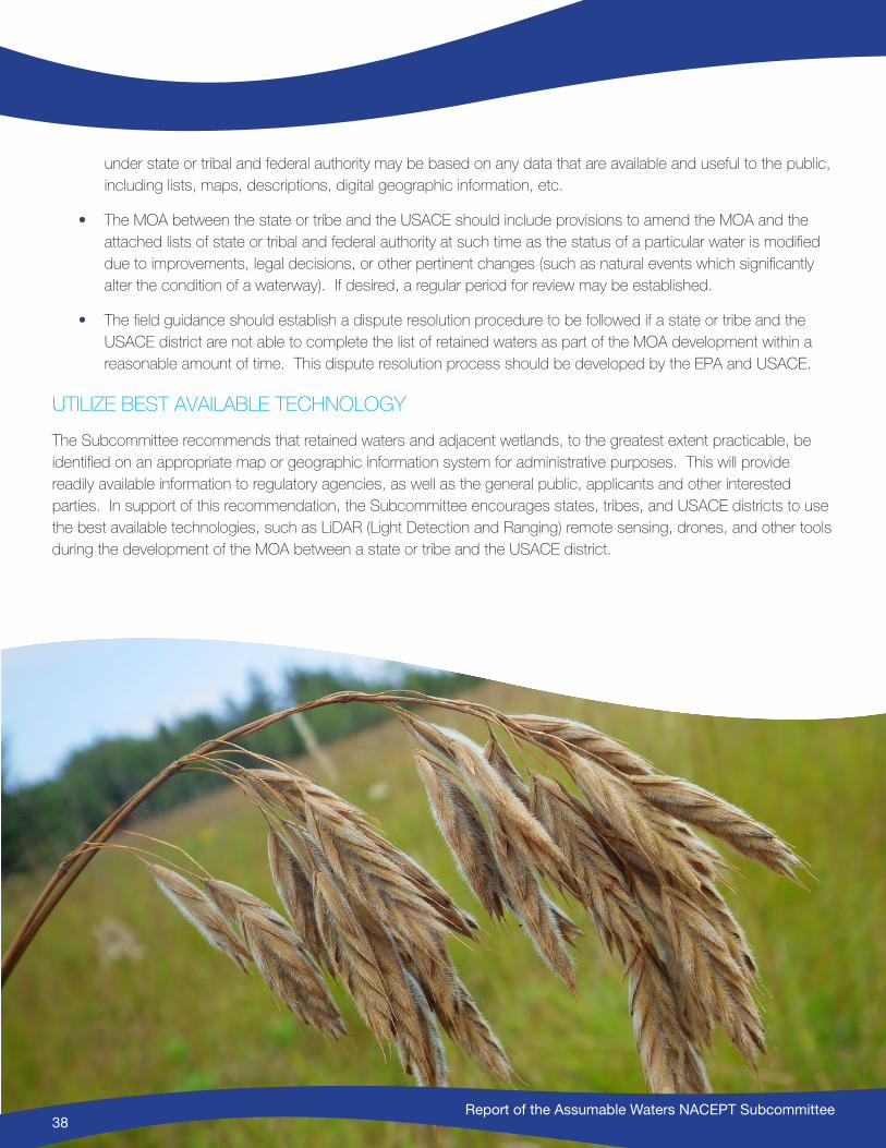
Report of the Assumable Waters NACEPT Subcommittee38
under state or tribal and federal authority may be based on any data that are available and useful to the public, including lists, maps, descriptions, digital geographic information, etc.
• The MOA between the state or tribe and the USACE should include provisions to amend the MOA and the attached lists of state or tribal and federal authority at such time as the status of a particular water is modified due to improvements, legal decisions, or other pertinent changes (such as natural events which significantly alter the condition of a waterway). If desired, a regular period for review may be established.
• The field guidance should establish a dispute resolution procedure to be followed if a state or tribe and the USACE district are not able to complete the list of retained waters as part of the MOA development within a reasonable amount of time. This dispute resolution process should be developed by the EPA and USACE.
UTILIZE BEST AVAILABLE TECHNOLOGY
The Subcommittee recommends that retained waters and adjacent wetlands, to the greatest extent practicable, be identified on an appropriate map or geographic information system for administrative purposes. This will provide readily available information to regulatory agencies, as well as the general public, applicants and other interested parties. In support of this recommendation, the Subcommittee encourages states, tribes, and USACE districts to use the best available technologies, such as LiDAR (Light Detection and Ranging) remote sensing, drones, and other tools during the development of the MOA between a state or tribe and the USACE district.
Report of the Assumable Waters NACEPT Subcommittee38

Report of the Assumable Waters NACEPT Subcommittee39
Appendix A: Tribal Findings, Issues, and Considerations during AssumptionSection 518 of the CWA, enacted as part of the 1987 amendments to the statute, authorizes the EPA to treat eligible Indian tribes in a manner similar to states (“treatment as a state“ or TAS) for a variety of purposes, including administering each of the principal CWA regulatory programs and receiving grants under several CWA authorities (81 FR at 30183). This includes CWA Section 404.
The Subcommittee, with the leadership of its two tribal participants, identified a set of “Tribal Issues” that the EPA, USACE, states, tribes and other interested parties should be aware of when considering assumption under CWA Section 404(g)(1). It should be noted that there may be specific jurisdictional and other legal matters that are in dispute within specific states and with specific tribes. The EPA may need to consider these issues as it addresses any application for assumption of the program.
USACE RETAINS INDIAN COUNTRY AQUATIC RESOURCES
The EPA-approved state assumed programs generally would not extend to waters and wetlands within Indian country. Instead, such areas would generally continue to be administered by USACE, at least until such time that a tribe is approved by the EPA to assume the 404 program itself.25 This retention of administration by USACE should be outlined in any MOA between the USACE and the state when such state wishes to assume the 404 program.
25 See 40 CFR 233.1(b).
Report of the Assumable Waters NACEPT Subcommittee40
INDIAN RESERVATION BOUNDARIES
Tribal Indian Reservation boundaries are not necessarily static; for instance, additional lands can be added to reservations and new reservations can be created. As stated in the Indian Reorganization Act of 1934 “The Secretary of the Interior is hereby authorized to proclaim new Indian reservations on lands acquired pursuant to any authority conferred by this Act, or to add such lands to existing reservations: Provided, that lands added to existing reservations shall be designated for the exclusive use of Indians entitled by enrollment or by tribal membership to residence at such reservations,” (25 US Code Section 467) and as provided by the Bureau of Indian Affairs regulations (25 CFR Section § 151.3, 151.10, and 151.11).
In addition, Indian Reservations can have varied land ownership patterns. Some Indian reservations consist solely of lands that are held in trust status with the United States. Other reservations may have mixed ownership of property within the reservation (including tribal, public and private ownership). Mixed ownership and trust status within reservations can occur for a variety of reasons including land inheritance, when and how the reservation was established, and treatment of the reservation by Congress as interpreted in court decisions. The EPA has interpreted CWA section 518 as including a delegation of authority by Congress to eligible Indian tribes to administer regulatory programs under the statute over their entire reservations, irrespective of who owns the land 81 FR 30183 (May 16, 2016).
LANDS OUTSIDE OF THE RESERVATION
In CWA Section 518(e)(2), the phrase “…or otherwise within the borders of an Indian reservation.” is interpreted to modify each category of land (i.e., “…held by an Indian tribe, held by the United States in trust for Indians, held by a member of an Indian tribe if such property interest is subject to a trust restriction on alienation…”).26 Thus, any land that an Indian tribe wishes to regulate under the CWA – including under section 404 – must qualify as Indian reservation land as used in CWA 518. Such lands must therefore be located within the exterior boundaries of a formal Indian reservation, or qualify as an informal Indian reservation – e.g., tribal trust lands located outside the boundaries of a formal reservation or Pueblos. Thus, privately owned reservation lands that are part of the reservation should generally be excluded from assumed state programs, and thus retained by USACE), or could generally be assumed by the relevant tribe.
Lands can be brought into trust at various times, before or after a state or tribe has assumed a 404 program, and trust lands can create a patchwork of assumed and retained waters. Thus, cooperative relationships and agreements should be developed between the federal agencies, states and tribes in order to appropriately administer the program. Therefore, the assumption MOAs between the states or tribes and the EPA and the USACE should contain language on how changes in the trust status of Indian land is going to be handled.
26 See Preamble to the Clean Water Act Treatment As a State – TAS rules at 56 FR 64881 and 58 FR 8177). (See also CWA Section 518(e)(2).

Report of the Assumable Waters NACEPT Subcommittee41
Appendix B: Michigan and New Jersey’s Assumed ProgramsCASE STUDY OF MICHIGAN PROGRAM
Michigan has a long history of leadership in environmental protection and management, beginning with passage of a state water pollution control statute in 1929. So with passage of the Federal Water Pollution Control Act Amendments of 1972, Michigan began working to align state programs with the new federal regulations to enable Michigan to administer the CWA programs. Michigan was delegated authority to administer the Section 402, National Pollution Discharge Elimination Program in 1973. In 1972 Michigan also passed an inland lakes and streams statute that established dredged or fill regulations over inland waters. Regulations over dredged or fill activities and bottomland occupations within the Great Lakes had been in place since 1955.
During the 1970’s as the federal agencies were developing implementation guidelines and regulations, and Congress was considering amendments to the CWA, Michigan began development of a wetland program and was building a partnership with the USACE. Michigan and the USACE signed an agreement in 1977 to use a joint permit application form for projects within all state and federally regulated waters, and to coordinate public hearings when required for those projects. Over the next several years, the agencies continued to align the state and federal programs to improve efficiency and reduce duplication, including issuance of additional federal general permits and state statutory amendments. Following passage of the 1977 CWA amendments that added Section 404(g)(1), Michigan passed a wetland statute in 1979 with the intention of assuming the Section 404 program.
In 1981 the agencies entered into two additional agreements to streamline the state and federal programs. The first was an agreement to coordinate enforcement actions and after-the-fact permitting procedures. The second was

Report of the Assumable Waters NACEPT Subcommittee42
an agreement to share staff resources; this agreement allowed the state to place staff in locations throughout the state to conduct site reviews for both state and federal permits, in exchange the USACE provided joint staff training, reimbursed state travel costs, and funded the development of public outreach materials.
This effort laid the groundwork for assumption of the 404 program. Michigan formally requested assumption in 1983 and the Environmental Protection Agency (EPA) approved the program the same year. With the signing of the USACE Memorandum of Agreement (MOA) in 1984, which identified the retained waters, Michigan became the first state to assume the 404 program27.
The EPA and USACE Memoranda
The 1983 MOA with the EPA provided the framework for Michigan’s administration of the 404 program. The agreement specifies the state’s responsibilities for permitting and enforcement, the federal oversight responsibilities including procedures for federal review of certain permit applications, and state program reporting requirements. The categories of permit applications which the EPA did not waive federal review under Section 404(j) are specifically defined; they include proposed state general permit categories and major discharges of dredged or fill material. Major discharges are further defined and include: discharges of toxic pollutants or hazardous substances; impacts to unique waters for a geographic region, commercial or recreational values of a significant area, or endangered or threatened species; and wetland fills, breakwater or seawall construction, or culvert enclosures of specified volumes and sizes.
Michigan’s program agreement with the EPA was updated in 2011 after an extensive review of Michigan’s program and nearly three decades of program changes at both the federal and state level. The updated agreement is substantially the same as the original agreement, with new language added to clarify responsibilities for coordination with other states and tribes, coordination with federal agencies for mitigation banks, and streamlining of reporting requirements.
The 1984 MOA with the USACE identifying retained waters is still in effect. In defining waters to be assumed by the state and the waters to be retained by the USACE the MOA simply states that all waters within the state are assumed other than waters identified by the language in 404(g)(1). The MOA quotes the 404(g)(1) language, and then states that those waters are identified on an attached list of “Navigable Waters of the United States in US Army Engineer District, Detroit, November 1981”. The list of navigable waters of the United States identifies specific waterways by name and location, and identifies the head of navigation that is the upstream limit of the USACE’s retained authority under the 404 program.
Current Status of Michigan’s Program
Michigan has been successfully implementing the 404 program for over 3 decades. But implementation requires continual coordination with the federal agencies. State staff screen each permit application to determine if the proposed project is located within assumed or retained waters. If the project is in a retained area, a copy of the application is forwarded to the USACE. Michigan still regulates all waters and wetlands throughout the state, so applications within retained waters are coordinated with the USACE. All application information is shared between the agencies, site inspections are coordinated when appropriate, and permit conditions and mitigation requirements
27 49 FR 38948, Oct. 2, 1984. Redesignated at 53 FR 20776, June 6, 1988. Redesignated at 58 FR 8183, Feb. 11, 1993. Effective date, October 16, 1984.

Report of the Assumable Waters NACEPT Subcommittee43
are coordinated to avoid conflicts and inconsistencies. Since Michigan has a robust wetland mitigation program and the state can own property, hold conservation easements, and hold financial instruments, state staff normally take the lead in negotiating and reviewing mitigation proposals. The state and USACE also coordinate compliance and enforcement actions within retained waters to reduce duplication and prevent conflicting compliance requirements.
Coordination with the United States Fish and Wildlife Service (US FWS) is also a necessary part of the program. State staff are responsible for screening applications for potential impacts to threatened and endangered species and coordinating with US FWS and state endangered species staff. State staff also work with US FWS to develop species specific screening criteria, permit conditions and best management practices.
State staff work continuously with the EPA staff to coordinate review of major discharge applications, new or revised general permit categories, major enforcement actions, and all statutory, rule or policy changes that affect the 404 program. The state has one staff person who is designated as the 404 program liaison to streamline communication between the agencies.
Annually Michigan processes approximately 3,000 to 4,000 permit applications under the 404 program in assumed waters. Normally 60 to 70 percent of those projects fall within the state’s general permit categories. Typically, the EPA reviews one to two percent of the total applications because they fall within the major discharge categories described in the state’s MOA with the EPA. In addition, state staff investigates and takes action on approximately 1000 to 1500 reports of non-compliance.
CASE STUDY OF NEW JERSEY PROGRAM
New Jersey is the most densely populated state in the nation with a population of 8,958,013 in 8,721.3 square miles or 1,195.5 people per square mile (2015 Statistics from the US Census). As a result, New Jersey faces many environmental issues in advance of other states and has developed an active and vocal grass roots environmental movement.
As early as 1917, New Jersey enacted a Waterfront Development law to protect navigation and ensure adequate dockage for shipping along the coast. In 1929, the state began protecting streams under the Flood Hazard Area Control Act which regulated structures placed within the natural waterway of any stream. The New Jersey Department of Environmental Protection was created on the first Earth Day, April 22, 1970. That same year, New Jersey passed the Coastal Wetlands Act.
In response to passage of the 1972 Federal Coastal Zone Management Act, in 1973 New Jersey passed the Coastal Area Facility Review Act. In 1977, the state’s Pinelands Preservation Act began protecting from development a unique area in the southern part of New Jersey. It also prohibited development in freshwater wetlands.
New Jersey does not have its own USACE District. The state is served by the New York District, located in New York City and serving New York state and the eastern portion of New Jersey; and the Philadelphia District, located in Philadelphia, Pennsylvania and serving Pennsylvania and the western part of New Jersey. In the 1980s, the USACE program included Nationwide permits which were self-regulating and that allowed up to 10 acres of impacts per permit. New Jersey used its Water Quality Certificate authority to try to limit the impacts. However, a review by the
Report of the Assumable Waters NACEPT Subcommittee44
US Fish and Wildlife Service of 40 wetland fill cases in northern New Jersey between 1980 and 1984 documented approximately 800 acres of wetland impacts resulting from illegal filling, Nationwide permits, and Individual permit activities.
In the mid-1980s, environmental groups in New Jersey united with the goal of obtaining a state freshwater wetlands protection law. On June 8, 1987, Governor Tom Kean enacted a building moratorium prohibiting all development in wetlands until passage of a wetland law. On July 1, 1987, New Jersey passed the Freshwater Wetlands Protection Act (FWPA), effective July 1, 1988.
The law contained a provision, directing the state to “take all appropriate action to secure the assumption of the permit jurisdiction exercise by the United States Army Corps of Engineers pursuant to the Federal Act.” (NJSA 13:9B-27) To fulfill this mandate, the statute was structured to give the state the necessary authority to assume the Federal permitting program. In addition, the state legislature appropriated sufficient funds for the Department of Environmental Protection to staff and equip a statewide, freshwater wetlands regulatory program independent of the USACE.
New Jersey submitted an application for assumption to the EPA in 1993. The program was approved and New Jersey became the second state to implement an assumed Federal 404 program in 1994.
MOA with the EPA
As required by the Federal Transfer Regulations28, New Jersey signed a memorandum of agreement with the EPA. In addition to those projects that continue to require Federal review in accordance with the EPA transfer regulations, New Jersey agreed that the following project types would also continue to get Federal review under its assumed program:
• Filling of 5 or more acres of wetlands;
• Significant reduction in ecological, commercial or recreational value of 5 or more acres;
• Culverts longer than 100 feet;
• Channelization of more than 500 feet of river or stream.
MOA with the Army USACE
As required by the Federal Transfer Regulations, the State of New Jersey signed a memorandum of agreement with the USACE29. The state and the USACE agreed to the following definition to distinguish assumed and non-assumed waters:
“All waters of the United States, as defined at 40 CFR Section 232.2(q), within the State of New Jersey will be regulated by NJDEP as part of their state program, with the exception of those waters which are presently used, or are susceptible to use in their natural condition or by reasonable improvement as a means to transport interstate or foreign commerce shoreward to their ordinary high water mark, including all waters which are subject to the ebb and flow of the tide shoreward to their mean high water mark, including wetlands adjacent thereto. For the purposes of this agreement, the USACE will retain regulatory authority over those
28 40 CFR Part 233: 404 State Program Regulations29 59 FR 9933, Mar. 2, 1994

Report of the Assumable Waters NACEPT Subcommittee45
wetlands that are partially or entirely located within 1,000 feet of the ordinary high water mark or mean high tide of the Delaware River, Greenwood Lake, and all water bodies which are subject to the ebb and flow of the tide.”
The “1,000 feet” criterion had two sources. First, the USACE traditionally took jurisdiction to elevation 10 in coastal areas in New Jersey under the Rivers and Harbors Act. They consider any wetlands and/or waters located between the water and 10 feet above sea level to be navigable waters or “wetlands adjacent thereto.” They estimated that on average, the distance from the Mean High Water Line landward to 10 feet above sea level is approximately 1,000 feet. In addition, the state’s wetland maps were drawn at a scale where one inch equals 1,000 feet. Therefore, the state and the USACE agreed to use 1,000 feet from the ordinary high water mark or mean high tide as the division between waters to be retained (regulated by both agencies), and those to be assumed (regulated by the state alone).
MOU with the US Fish and Wildlife Service
The US Fish and Wildlife Service (FWS) opposed assumption by the State of New Jersey. In order to assuage their concerns, the state voluntarily signed a memorandum of understanding (MOU) with both the EPA and FWS. The MOU requires the state to provide certain applications directly to the FWS for review if they are located within municipalities known to contain federally-listed threatened or endangered species.
Coordination with State Historic Preservation Office (SHPO)
As part of its assumed program, the state also screens applications for referral to the SHPO to comply with Section 106 of the National Historic Preservation Act (16 USC Section 470(f)).
Current Status of Program
The state of New Jersey reviews all incoming wetlands/waters permit applications regardless of whether they are in assumed or non-assumed waters. The state also conducts jurisdictional determinations throughout most of the state. The state prescreens incoming permit applications to identify projects constituting “major discharges,” which are then sent to the EPA for Federal review. In addition, if a permit application falls within one of the identified municipalities with federally-listed threatened or endangered species, and constitutes one of the permit types of concern to the FWS, the state screens the application and sends a copy to the FWS. The FWS returns comments to DEP and the EPA for consideration. If the state cannot satisfy FWS concerns, the project begins a new review with the EPA through the “major discharge” process. The state cannot approve a Section 404 permit over the EPA objections.
In those cases where a project is in a non-assumed water, the state issues its state permit independently of the USACE. However, monthly coordination meetings with the USACE let the agencies compare information on projects under review by both agencies. In addition, the agencies coordinate required mitigation. New Jersey also reviews and approves mitigation banks independently in assumed areas. In non-assumed areas, the state is a member of both the New York and Philadelphia USACE Interagency Review Teams.
The state also conducts compliance and enforcement for violations in non-assumed waters.

Report of the Assumable Waters NACEPT Subcommittee46
Over the years, the state has made between 550 and 2,000 permit decisions annually. Of these, on average fewer than 10 applications per year require coordination with the EPA as “major discharges,” approximately 80 per year required FWS review, and between 225 and 250 are coordinated with the State Historic Preservation Office.
In addition, the state’s Enforcement Bureau has undertaken an average of 1,000 actions annually on reports of non-compliance.
Report of the Assumable Waters NACEPT Subcommittee46
Report of the Assumable Waters NACEPT Subcommittee47
Appendix C: Letter from the Association of Clean Water Administrators, the Environmental Council of the States, and the Association of State Wetland Managers
Report of the Assumable Waters NACEPT Subcommittee48
April 30, 2014
Nancy K. Stoner Acting Assistant Administrator for Water U.S. Environmental Protection Agency William Jefferson Clinton Building 1200 Pennsylvania Avenue, NW (4101M) Washington, DC 20460
Via email to: [email protected]
Dear Acting Assistant Administrator Stoner:
Re: Assumable Waters under Clean Water Act Section 404
In the rule proposed by the U.S. Environmental Protection Agency (EPA) and the U.S. Army Corps of Engineers (Corps) regarding the scope of the definition of “waters of the United States,” a statement in the preamble explains that the rule does not affect the scope of waters subject to state assumption in accordance with §404(g). 79 Fed. Reg. 22,188, p. 22,200 (April 21, 2014). The undersigned organizations appreciate that such language was included in the proposed rule addressing this critical aspect of state §404 program assumption.
We agree with the preamble statement in the rule that “[c]larification of waters that are subject to assumption by states or tribes or retention by the Corps could be made through a separate process under section 404(g)” (ibid). We recommend that steps to further clarify the scope of assumable and non-assumable waters be initiated in a timely manner. We are concerned that states currently considering assumption are having difficulty making progress because of the current uncertainty.
We would appreciate the opportunity to actively engage in a discussion with EPA to address this issue. Our organizations recognize that any steps toward clarification must be undertaken thoughtfully in accordance with the provisions of §404(g), and without altering the existing state 404 programs in Michigan and New Jersey.
Clear identification of assumable and non-assumable waters has been made more difficult by legal decisions that address terms such as “navigable” and “adjacent.” Nonetheless, Congress intended that states be able to assume regulatory responsibility for the majority of waters within their boundaries. Clarification of assumable waters will help to facilitate state assumption where it is desired – providing benefits to the public, the resource, and the state and federal agencies.
Under §404 of the Clean Water Act – all waters regulated by the Corps or by a state/tribal program – are deemed “waters of the United States.” We believe that “other waters,” as well as some portion of both “navigable waters,” and “adjacent wetlands” may be administered by a state or tribe in accordance with 404(g). We look forward to discussions with EPA to explore this very important area of public policy.
Report of the Assumable Waters NACEPT Subcommittee49
Our goal is to work collaboratively to discern the criteria that will be used by a state/tribe, EPA, and the Corps to identify assumable/non-assumable waters pursuant to §404(g). We would also like to reach agreement on how to formalize these criteria (e.g., Memorandum of Understanding). Several steps may be needed to address both the immediate concerns of states pursuing assumption and the needs of those that may do so in the future.
Our organizations are committed to supporting state efforts to assume the Section 404 program by identifying issues and working with partners to resolve them. See, for example, ECOS Resolution #08-3 on State Delegation of the Clean Water Act Section 404 Permit Program – originally approved in 2008 – was on April 2, 2014 reaffirmed, with the addition of the following language: “[NOW, THEREFORE, BE IT RESOLVED THAT THE ENVIRONMENTAL COUNCIL OF THE STATES] Encourages U.S. EPA to work with states to bring clarity and certainty to the identification of assumable and non-assumable waters.”
We look forward to a timely and productive discussion with you. Please contact Jeanne Christie of ASWM at 207-892-3399 or [email protected], to discuss this request. Thank you again for your attention to this matter. Sincerely, Alexandra Dapolito Dunn Sean Rolland Jeanne Christie ECOS ACWA ASWM Cc: Ken Kopocis, EPA Benita Best-Wong, EPA Jim Pendergast, EPA Bill Ryan, OR DSL Ben White, AK Eric Metz, OR DSL Ginger Kopkash, NJ Bill Creal, MI

Report of the Assumable Waters NACEPT Subcommittee50
Appendix D: List of Subcommittee Members
COLLIS G. ADAMS, CWS, CPESCWetlands Bureau AdministratorNew Hampshire Department of Environmental ServicesLand Resources Management
VIRGINIA S. ALBRECHT Special Counsel National Association of Home BuildersHunton & Williams LLP
CRAIG W. AUBREYChief, Division of Environmental ReviewEcological Services ProgramUS Fish and Wildlife Service HeadquartersEcological Services, MS: ES
TREVOR BAGGIORE Division Director, Water Quality Arizona Department of Environmental Quality
LAUREEN MONICA BOLESNACEPT Liaison
PEG BOSTWICKSenior Policy AnalystAssociation of State Wetland ManagersGreat Lakes Office
DAVID L. DAVIS, CPWD, PWSDirector, Office of Wetlands & Stream ProtectionVirginia Department of Environmental Quality
JAMES P. DENOMIE Tribal ConsultantTribal Member of Bad River Chippawa Tribe of Lake SuperiorMidwest Alliance of Sovereign Tribes
Report of the Assumable Waters NACEPT Subcommittee51
TOM DRISCOLLGovernment Relations RepresentativeNational Farmers Union
DAVID S. EVANS, DEPUTY DIRECTORCo-Chair of the SubcommitteeOffice of Wetlands, Oceans, and WatershedsUSEPA OWOW (resigned as of 12-9-2016 due to employment change)
KIMBERLY FISH Assistant Division ChiefMichigan Department of Environmental QualityWater Resources Division
RICHARD D. GITARWater Regulatory Specialist/Tribal InspectorOffice of Water ProtectionFond du Lac Reservation
JAN GOLDMAN-CARTERDirector of Wetlands and Water Resources, National Wildlife FederationNational Advocacy Center
MICHELLE HALEDirector, Division of Water Alaska Department of Environmental Conservation
WILLIAM L. JAMESUS Army Corps of Engineers National Mining Expert
LES LEMMWetlands Section ManagerMinnesota Board of Water and Soil Resources
SUSAN D. LOCKWOODEnvironmental Specialist 4New Jersey DEP Division of Land Use Regulation
ERIC D. METZ, P.W.S.Planning and Policy ManagerAquatic Resource Management ProgramOregon Department of State Lands
BARRY RABE, PH.DCo-Chair of the SubcommitteeDirector of the Center for Local, State, and Urban Policy Gerald R. Ford School of Public Policy University of Michigan
DAVE ROSSSenior Assistant Attorney GeneralWyoming Attorney General’s OfficeWater & Natural Resources Division (resigned as of 5-16-2016 due to employment change)
GARY T. SETZERPolicy Advisor, Office of the SecretaryMaryland Department of the Environment
MICHAEL J. SZERLOG, MANAGERAquatic Resources UnitOffice of Environmental Review and Assessment, Environmental Protection Agency, EPA Region 10

Report of the Assumable Waters NACEPT Subcommittee52
Appendix E: Subcommittee CharterINTRODUCTION
Section 404(g) of the Clean Water Act (CWA) lays out the requirements for the assumption and implementation of state and tribal CWA section 404 permitting programs. Congress, with the addition of CWA section 404(g), made clear that states and tribes wishing to assume administration of the dredge and fill permit program, could do so for certain waters. This Subcommittee under the National Advisory Council for Environmental Policy and Technology (NACEPT) will focus on a very narrow and specific charge related to which waters a state or tribe assumes permitting responsibility for under an approved CWA section 404 program and for which waters the US Army Corps of Engineers (USACE) will retain CWA section 404 permitting authority. To be known as the “Assumable Waters Subcommittee,” (Subcommittee), the Subcommittee will be asked to provide advice and develop recommendations on how the US Environmental Protection Agency (EPA) can best clarify for which waters the state/tribe has CWA section 404 permit responsibilities, and for which waters the USACE retains CWA section 404 permit responsibility, under an approved state/tribal program. This effort is part of the Administrator’s priorities as it supports states and tribes seeking to assume the CWA section 404 program by providing clarity on the scope of waters for which they would be responsible for administering the CWA section 404 program. Specifically, this effort will address the states’ request to provide clarity on this issue enabling them to assess and determine the geographic scope and costs associated with implementing an approved program.
BACKGROUND
The NACEPT is a Federal Advisory Committee chartered under the Federal Advisory Committee Act (FACA), Public Law 92–463. The EPA established the NACEPT in 1988 to provide advice to the EPA Administrator on a broad
Report of the Assumable Waters NACEPT Subcommittee53
range of environmental policy, management, and technology issues. The EPA is now seeking to form a subcommittee under the NACEPT, to be known as the Assumable Waters Subcommittee (Subcommittee) to provide advice on how the EPA can best clarify the waters that a state or tribe may assume permitting responsibility for under an approved CWA dredge and fill permit program. Subcommittee members, like the parent NACEPT committee, serve as representatives from academia, industry, non-governmental organizations, and federal, state, tribal, and local governments.
The Subcommittee is being formed to provide advice and recommendations concerning a focused, but critical, aspect of implementing the CWA section 404 program for the discharge of dredge and fill materials. The USACE currently evaluates CWA section 404 permit applications for activities in the majority of the nation’s waters subject to the CWA. Although states and tribes may assume the dredge and fill permit responsibilities pursuant to section 404(g) of the CWA, only two states (Michigan and New Jersey) and no tribes have assumed such responsibility to date. When a state or tribe considers assuming such responsibilities, among the first questions that needs to be answered is for which waters will the state or tribe assume permitting responsibility and for which waters will the USACE retain permitting authority. States have raised concerns to the EPA that section 404 of the CWA and its implementing regulations lack sufficient clarity to enable states and tribes to estimate the extent of waters for which they would assume program responsibility and thus calculate associated program implementation costs.30 The lack of clarity on these questions has been identified by the states as a challenge to pursuing assumption as envisioned under the CWA.31
The Subcommittee will have a limited duration and narrow focus. Other aspects of state or tribal assumption will not be within the scope of the deliberations for this Subcommittee. For example, the Subcommittee will not be deliberating on the merits of assumption, nor on any aspect of the larger question of which waters are “waters of the US.” It will focus on how the EPA can clarify the waters for which a state or tribe assumes CWA section 404 permitting responsibility and for which waters the USACE will retain this authority.
CHARGE TO THE SUBCOMMITTEE
The final Subcommittee report to NACEPT should provide advice and recommendations to EPA on how to clarify for which waters states and tribes will assume CWA section 404 permitting responsibilities, and for which waters the USACE will retain permitting authority. The recommendations should reflect consideration of the following assumptions:
1. A CWA section 404 permit is required – meaning there is an activity regulated under section 404 that will resultin a discharge of dredge or fill material to a Water of the US
2. Any recommendation must be consistent with the CWA and in particular section 404(g)
3. Clarity regarding who is the permitting authority (the state/tribe or the USACE) should be easily understood andimplementable in the field
30 Environmental Council of States, the Association of Clean Water Administrators, and the Association of State Wetland Managers letter. April 30, 2014. Letter can be found in the docket.
31 Ibid
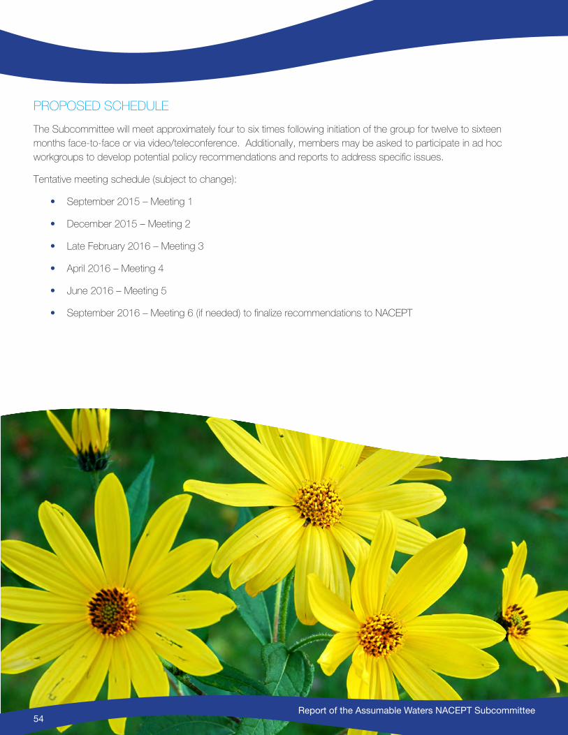
Report of the Assumable Waters NACEPT Subcommittee54
PROPOSED SCHEDULE
The Subcommittee will meet approximately four to six times following initiation of the group for twelve to sixteen months face-to-face or via video/teleconference. Additionally, members may be asked to participate in ad hoc workgroups to develop potential policy recommendations and reports to address specific issues.
Tentative meeting schedule (subject to change):
• September 2015 – Meeting 1
• December 2015 – Meeting 2
• Late February 2016 – Meeting 3
• April 2016 – Meeting 4
• June 2016 – Meeting 5
• September 2016 – Meeting 6 (if needed) to finalize recommendations to NACEPT
Report of the Assumable Waters NACEPT Subcommittee54
Report of the Assumable Waters NACEPT Subcommittee55
Appendix F: The Legislative History of Section 404(g)(1) of the Clean Water Act32 INTRODUCTION
Section 404 of the Clean Water Act (CWA) authorizes the US Army Corps of Engineers (the USACE) to issue permits for the discharge of dredged or fill material into “navigable waters.”33 Pursuant to section 404(g)(1), States, with approval from the Environmental Protection Agency (EPA), may assume authority to administer the 404 permit program in some but not all navigable waters. The waters that a state may not assume, and which the USACE must retain even after a state has assumed the program, are defined in a parenthetical phrase in section 404(g)(1) as:
(… those waters which are presently used, or are susceptible to use in their natural condition or by reasonable improvement as a means to transport interstate or foreign commerce shoreward to their ordinary high water mark, including all waters which are subject to the ebb and flow of the tide shoreward to their mean high water mark, or mean higher high water mark on the west coast, including wetlands adjacent thereto) …34
This memorandum explores the meaning of this parenthetical language by reviewing the legislative history of the 1977 CWA amendments that led to section 404(g)(1). The legislative history summarized below includes the reports of the House Committee on Public Works and Transportation and the Senate Committee on Environment and Public Works, passages from earlier versions of both the House and Senate bills, and excerpts from the Conference
32 Prepared by Virginia S. Albrecht, Jan Goldman-Carter, and Dave Ross33 33 USC § 1344(a).34 33 USC § 1344(g)(1).

Report of the Assumable Waters NACEPT Subcommittee56
Report regarding the final language of the amendments. After careful review of this material, it is clear that the waters Congress intended the USACE to retain after a state assumed 404 authority are: (1) the waters identified by the USACE as Phase I waters in its 1975 regulations, except for those navigable waters of the United States deemed navigable based solely on historic uses, and (2) wetlands adjacent to the retained Phase I waters.35
HISTORY OF SECTION 404(g)(1)
Responding to a court order, the USACE proposes to expand its definition of navigable waters for section 404.
After the CWA was enacted in 1972, the USACE promulgated regulations defining the CWA term “navigable waters” synonymously with the RHA term “navigable waters of the United States.” The National Wildlife Federation and the Natural Resources Defense Council challenged the USACE’ CWA definition, and in March 1975 the District Court for the District of Columbia ordered the USACE to issue new regulations broadening the definition to accord with the broader water quality purposes of the CWA.36 On July 25, 1975, in compliance with the court order, the USACE issued revised regulations creating a phased schedule for expanding the program, as follows:
• Phase I: [effective immediately] discharges of dredged material or of fill material into coastal waters and coastal wetlands contiguous or adjacent thereto or into inland navigable waters of the United States37 and freshwater wetlands contiguous or adjacent thereto are subject to … regulation.
• Phase II: [effective July 1, 1976] discharges of dredged material or of fill material into primary tributaries, freshwater wetlands contiguous or adjacent to primary tributaries, and lakes are subject to … regulation.
• Phase III: [effective after July 1, 1977] discharges of dredged material or of fill material into any navigable water [including intrastate lakes, rivers and streams landward to their ordinary high water mark and up to the headwaters that are used in interstate commerce] are subject to … regulation.38
35 As described below, Phase I waters were understood to be “navigable waters of the United States” already regulated by the USACE under section 10 of the Rivers and Harbors Act (RHA), plus adjacent wetlands.
36 Nat. Res. Def. Council, Inc. v. Callaway, 392 F. Supp. 685 (D.D.C. 1975). The CWA defines the term “navigable waters” to mean “the waters of the United States.” At the time the CWA was passed, the USACE had been regulating “navigable waters of the United States” under the Rivers and Harbors Act for more than 100 years. The strikingly similar language in the two statutes led to confusion. The USACE’ initial post-CWA regulations treated the terms synonymously. 39 Fed. Reg. 12,115, 12,119 (Apr. 3, 1974). But the two statutes had different purposes – the RHA was focused on maintaining navigable capacity, the CWA on water quality. And the CWA Conference Report stated that the “term ‘navigable waters’ [should] be given the broadest possible constitutional interpretation unencumbered by agency determinations which have been made or may be made for administrative purposes.” S. Rep. No. 92-1236, at 144 (1972), reprinted in Comm. oN pub. WoRkS, 93d CoNg., 1 A LegiSLAtive HiStoRy of tHe WAteR poLLutioN CoNtRoL ACt AmeNdmeNtS of 1972, at 281, 327 (Jan. 1973).
37 The term “navigable waters of the United States” is a term of art used to reference waters subject to the USACE jurisdiction under the RHA. The USACE defined the term in the 1975 regulations as “waters that have been used in the past, are now used, or are susceptible to use as a means to transport inter-state commerce landward to their ordinary high water mark and up to the head of navigation as determined by the Chief of Engineers, and also waters that are subject to the ebb and flow of the tide shoreward to their mean high water mark…. See 33 CFR 209.260 … for a more definitive explanation of this term.” 40 Fed. Reg. 31,320, 31,324 (July 25, 1975). The regulatory cross-reference included in this definition was to the USACE’ then current RHA regulations. Those regulations emphasized that, “[p]recise definitions of ‘navigable waters’ or ‘navigability’ are ultimately dependent on judicial interpretation, and cannot be made conclusively by administrative agencies.” 33 CFR § 209.260(b) (1973). Those regulations were later updated, and now read “[p]recise definitions of ‘navigable waters of the United States’ or ‘navigability’ are ultimately dependent on judicial interpretation and cannot be made conclusively by administrative agencies.” 33 CFR § 329.3 (2015).
38 40 Fed. Reg. at 31,326.
Report of the Assumable Waters NACEPT Subcommittee57
Responding to the USACE’ regulations, the House Committee on Public Works writes a bill to limit 404 jurisdiction to Phase I waters.
Reviewing the new USACE regulations, the House Committee on Public Works and Transportation expressed concern that “full implementation of this permit program under the new regulations would have a dramatic effect on the overall Corps of Engineers permit program.”39 The Committee Report noted that permits under the RHA numbered close to 11,000 per year and were expected to remain constant, but the new 404 regulations would increase 404 applications from 2,900 to 30,000 per year as Phases II and III became effective.40 The Committee was concerned that the expanded 404 program “will prove impossible of effective administration and … discourage the States from exercising their present responsibilities in protecting water and wetland areas.”41 The Committee report stated that environmental protection should be a shared responsibility of the States and the Federal government. Noting that “[t]he Federal government has traditionally had the responsibility of protecting the navigable waters of the United States for public use and enjoyment,” the Committee concluded that “activities addressed by section 404, to the extent they occur in waters other than navigable waters of the United States … are more appropriately and more effectively subject to regulation [by] the States.”42
The House bill tracks the RHA definition, except it omits “historic” navigable waters of the United States.
To address the concerns identified in the Committee report, section 17 of the Committee bill, H.R. 9560, added a definition of “navigable waters” to be applied to the 404 program that is “the same as the definition of navigable waters of the United States as it has evolved over the years through court decisions with one exception. [It] omits the historical test of navigability.”43 The Committee noted that the historical test had been used “to classify as navigable … many bodies of water … [that] were not capable of supporting interstate commerce in their existing condition or with reasonable improvement,”44 for example, waters that were used in the fur trade in the 1700’s, “where traders would transport their furs by trail to the lake, across the lake by boat, and then again by trail into another State.”45 Similarly, “small lakes located entirely within one State, which were part of a highway of commerce in the 1800’s by virtue of their proximity to a railway track which led into another State, [had] been classified as navigable.”46 Thus, the Committee intended to exclude “small intra-state lakes … which could not conceivably be used today or in the future for interstate commerce.”47 The Committee “fe[lt] strongly that if a water is not susceptible of use for the transport of interstate or foreign commerce in its present condition or with reasonable improvement, then it should not be considered a ‘navigable water of the United States.’”48
39 H.R. Rep. No. 94-1107, at 22 (1976).40 Id.41 Id.42 Id.43 Id. at 23.44 Id.45 Id.46 Id.47 Id. at 23-24.48 Id. at 24
Report of the Assumable Waters NACEPT Subcommittee58
Reflecting these Congressional intentions, section 17 read as follows:
The term “navigable waters” as used in this section shall mean all waters which are presently used, or are susceptible to use in their natural condition or by reasonable improvement as a means to transport interstate or foreign commerce shoreward to their ordinary high water mark, including all waters which are subject to the ebb and flow of the tide shoreward to their mean high water mark (mean higher high water mark on the west coast).49
As discussed below, section 17 morphed during the legislative process, and the above language ended up in 404(g)(1) and was used to describe the navigable waters the USACE would retain in a case of state assumption. The language “wetlands adjacent thereto” was added to the final bill separately.
During debate in the House, the 404 permit requirement is extended to certain wetlands, and certain activities are exempted.
Section 17 was debated vigorously on the House floor in 1976.50 Many vehemently opposed restricting the USACE’ jurisdiction, while proponents of section 1751 feared the USACE’s infringement on States’ authorities and farmers’ operations.52 In a compromise, the final House bill included the Committee’s definition of “navigable waters” (for 404 purposes), but protected wetlands by requiring 404 permits for dredge and fill activities in “coastal wetlands and … those wetlands lying adjacent and contiguous to navigable streams.”53 The bill did not include wetlands in the definition of navigable waters, however.
The bill also exempted from the permit program normal farming activities, ranching, and the construction or maintenance of farm or stock ponds and irrigation ditches.54 Additionally, it created a process for States to administer the program themselves whenever the Secretary of the Army found that they have sufficient legal authority and capability to carry out such functions and that the delegation of authority would be within the public interest.55 The House of Representatives passed H.R. 9560 and approved these amendments to the 404 program on June 3, 1976.56
The Senate bill creates a mechanism for States to assume the 404 program but does not modify the definition of navigable waters.
The Senate took up the bill in the summer of 1977. Emphasizing the ambitious water quality goals of the 1972 Clean Water Act, the Senate Committee on Environment and Public Works declined to redefine “navigable waters” for purposes of the 404 program. Instead, the Senate bill, S. 1952, in section (l)(5), allowed States to assume the
49 Id. at 63.50 See 122 CoNg. ReC. 16,514-73 (June 3, 1976).51 Note: In the final bill, the definition of “navigable waters” appears in section 16. Id. at 16,572.52 See id. at 16,514-73.53 Id. at 16,553.54 Id. at 16,552.55 Id. at 16,572.56 Id. at 16,569.

Report of the Assumable Waters NACEPT Subcommittee59
primary responsibility for implementing the permit program “outside the USACE program in the so-called phase I waters.”57 The waters that would be retained by the USACE if a state assumed the program were the same waters the House bill had defined as “navigable waters” except section (l)(5) added adjacent wetlands:
[A]ny coastal waters of the United States subject to the ebb and flow of the tide, including any adjacent marshes, shallows, swamps and mudflats, and any inland waters of the United States that are used, have been used or are susceptible to use for transport of interstate or foreign commerce, including any adjacent marshes, shallows, swamps and mudflats.58
S. 1952 would allow the States to assume authority over “phase 2 and phase 3 waters.”59 The assumption procedures were modeled on the 402 procedures for transfer of National Pollutant Discharge Elimination System (“NPDES”) authority to the States in the hopes that the familiar process would expedite state adoption of the program.60 The amendment also exempted activities similar to those exempted in the House bill and provided for general permits to eliminate delays and administrative burdens associated with the program.61 The Senate concluded that until the approval of a state program for Phase II and Phase III waters, the USACE would administer section 404 in all navigable waters.62 The Senate passed S. 1952 on August 4, 1977.63
The final bill does not change the definition of “navigable waters” but does provide for state assumption that would effectively limit USACE permitting authority in assumed States to Phase I waters.
Ultimately, the final bill, H.R. 3199, referred to as the 1977 Clean Water Act Amendments, did not change the definition of navigable waters for the 404 program. Instead, the amendments were a combination of the House and Senate bills. While members of the House, and more specifically the House Committee on Public Works and Transportation, wanted to redefine “navigable waters” for the 404 program, others strongly opposed such restrictions. Both chambers agreed, however, that the States could properly assume authority for administering the 404 program in waters other than those called out in section 17 of the House bill and section (l)(5) of the Senate bill. Accordingly, the conferees agreed upon an amendment that would leave the definition of “navigable waters” unchanged, but would allow the States to assume the program in most waters.
Thus, under the 1977 amendments, the States can administer an individual and general permit program for the discharge of dredged or fill material into “phase 2 and 3 waters after the approval of a program by the Administrator.”64
57 S. Rep. No. 95-370, at 75 (1977) reprinted in Comm. oN eNv’t & pubL. WoRkS, 95tH CoNg., 4 A LegiSLAtive HiStoRy of tHe CLeAN WAteR ACt of 1977 (“LegiS. HiStoRy 1977”), at 635, 708 (Oct. 1978).
58 4 LegiS. HiStoRy 1977, at 830.59 Id. at 708.60 Id. at 710-11.61 Id. at 707.62 Id. at 708.63 123 CoNg. ReC. 26,775 (Aug. 4, 1977).64 H.R. Rep. No. 95-830, at 101 (1977) reprinted in 3 LegiS. HiStoRy 1977, at 185, 285.

Report of the Assumable Waters NACEPT Subcommittee60
If and when a state assumed the program, the C’ permitting authority would be limited to “those waters defined as the phase I waters in the Corps … 1975 regulations, with the exception of waters considered navigable solely because of historical use.”65
The final bill inserted the language that the House Committee had originally used to limit USACE jurisdiction, except that the Conference Committee added “wetlands adjacent thereto” to the parenthetical phrase defining the waters over which the USACE would always retain permitting authority.66
The legislative history in both the House and the Senate evidences a Congressional expectation that most States would assume the 404 program, and therefore effectively limit USACE permitting authority to Phase I waters.
By using the established mechanism in section 402 …, the committee anticipates the authorization of state management of the [404] permit program will be substantially expedited. At least 28 state entities which have already obtained approval of the national pollutant discharge elimination system under the section should be able to assume the program quickly.67
Also, “the corps [conducted] … a study [in 1976] to determine the scope of state programs similar to or duplicative of corps regulations and to determine the interest of the States in accepting delegation of the 404 program.”68 Based on the preliminary responses of 52 states and territories, 34 indicated their intent, under certain conditions, such as federal funding, to assume the dredge and fill program.69 Only 6 responded that they would not seek assumption of the program, and 12 were undecided.70
Summary of Key Points
The language in the 404(g)(1) parenthetical phrase that defines the waters over which the USACE will retain jurisdiction in an assumed state is identical to the language used by the House Committee to narrow the definition of “navigable waters,” except that it includes “wetlands adjacent thereto.”
Congress intended that the parenthetical language be interpreted to mean the same waters as the USACE had defined as Phase I waters in its 1975 regulations, except those deemed navigable based solely on historical use. Thus, waters deemed navigable based on historical use only are assumable by a state.
The 1977 Congress anticipated that most states would assume the 404 program and therefore regulate dredge and fill activities in Phase II and III waters, leaving the USACE with authority over Phase I waters (including their adjacent wetlands but excluding historical use waters).
65 123 CoNg. ReC. 38,969 (Dec. 15, 1977). The USACE’s July 19, 1977 final regulations characterized Phase I as covering “waters already being regulated by the Corps[ ] plus all adjacent wetlands to these waters.” 42 Fed. Reg. 37,122, 37,124 (July 19, 1977).
66 H.R. Rep. No. 95-830, at 39, reprinted in 3 LegiS. HiStoRy 1977, at 285.67 S. Rep. No. 95-370, at 77-78, reprinted in 4 LegiS. HiStoRy 1977, at 710-11.68 H.R. Rep. No. 95-139, at 67, reprinted in 4 LegiS. HiStoRy 1977, at 1196, 1262.69 Id.70 Id.
Report of the Assumable Waters NACEPT Subcommittee61
The parenthetical waters identified by the USACE as Phase I waters in its 1975 regulations incorporated the description of “navigable waters of the United States” already regulated by the USACE under section 10 of the RHA, except the parenthetical excluded waters deemed navigable based solely on historical use, and included adjacent wetlands. The USACE’s regulations at the time emphasized that “[p]recise definitions of ‘navigable waters’ or ‘navigability’ are ultimately dependent on judicial interpretation, and cannot be made conclusively by administrative agencies.” 33 CFR § 209.260(b) (1973). The language changed later, and the current regulation now states “[p]recise definitions of ‘navigable waters of the United States’ or ‘navigability’ are ultimately dependent on judicial interpretation and cannot be made conclusively by administrative agencies.” 33 CFR § 329.3 (2015).
Report of the Assumable Waters NACEPT Subcommittee61