university of oulu p.o. box universitatis ouluensis a
TRANSCRIPT

U N I V E R S I TAT I S O U L U E N S I SACTAA
SCIENTIAE RERUMNATURALIUM
OULU 2006
A 452
Jyrki Autio
ENVIRONMENTALFACTORS CONTROLLINGTHE POSITION OFTHE ACTUAL TIMBERLINE AND TREELINE ON THE FELLS OF FINNISH LAPLAND
FACULTY OF SCIENCE, DEPARTMENT OF GEOGRAPHY,UNIVERSITY OF OULU
ABCDEFG
UNIVERS ITY OF OULU P.O. Box 7500 F I -90014 UNIVERS ITY OF OULU F INLAND
A C T A U N I V E R S I T A T I S O U L U E N S I S
S E R I E S E D I T O R S
SCIENTIAE RERUM NATURALIUM
HUMANIORA
TECHNICA
MEDICA
SCIENTIAE RERUM SOCIALIUM
SCRIPTA ACADEMICA
OECONOMICA
EDITOR IN CHIEF
EDITORIAL SECRETARY
Professor Mikko Siponen
Professor Harri Mantila
Professor Juha Kostamovaara
Professor Olli Vuolteenaho
Senior assistant Timo Latomaa
Communications Officer Elna Stjerna
Senior Lecturer Seppo Eriksson
Professor Olli Vuolteenaho
Publication Editor Kirsti Nurkkala
ISBN 951-42-8006-7 (Paperback)ISBN 951-42-8007-5 (PDF)ISSN 0355-3191 (Print)ISSN 1796-220X (Online)
A 452
AC
TA Jyrki A
utio
A452etukansi.kesken.fm Page 1 Friday, January 27, 2006 10:07 AM


A C T A U N I V E R S I T A T I S O U L U E N S I SA S c i e n t i a e R e r u m N a t u r a l i u m 4 5 2
JYRKI AUTIO
ENVIRONMENTAL FACTORS CONTROLLING THE POSITION OF THE ACTUAL TIMBERLINE AND TREELINE ON THE FELLS OF FINNISH LAPLAND
Academic Dissertation to be presented with the assent ofthe Faculty of Science, University of Oulu, for publicdiscussion in Raahensali (Auditorium L10), Linnanmaa, onFebruary 25th, 2006, at 12 noon
OULUN YLIOPISTO, OULU 2006

Copyright © 2006Acta Univ. Oul. A 452, 2006
Supervised byProfessor Olavi Heikkinen
Reviewed byProfessor Taneli KolströmProfessor Jukka Käyhkö
ISBN 951-42-8006-7 (Paperback)ISBN 951-42-8007-5 (PDF) http://herkules.oulu.fi/isbn9514280075/ISSN 0355-3191 (Printed )ISSN 1796-220X (Online) http://herkules.oulu.fi/issn03553191/
OULU UNIVERSITY PRESSOULU 2006

Autio, Jyrki, Environmental factors controlling the position of the actual timberlineand treeline on the fells of Finnish LaplandFaculty of Science, Department of Geography, University of Oulu, P.O.Box 3000, FI-90014University of Oulu, Finland Acta Univ. Oul. A 452, 2006Oulu, Finland
AbstractAir and soil temperatures, snow cover, serious snow load damage to coniferous trees, wind,topography and edaphic factors on the fells situated between 67°N and 68°N in Finnish Lapland aredescribed and their influence on the location of the actual timberline and treeline is discussed. Inaddition the relation between annual climate conditions and pollen deposition in the timberlineecotone is analysed and the results of seedling density monitoring in the same environment arepresented. The potential for the actual timberline and treeline to advance to a higher elevation is alsodiscussed. The field studies were carried out on the fells of Aakenustunturi, Yllästunturi andPyhätunturi.
The average altitude of the actual timberline varies from 370 metres to 402 metres a.s.l. The actualtimberline is hardly ever composed of a single tree species but featured alternating occurrences ofNorway spruce (Picea abies), Scots pine (Pinus sylvestris) and mountain birch (Betula pubescens ssp.czerpanovii). The mean tetratherms on the southern and northern slopes (+10.3°C and +10.1°C,respectively), the mean maximum tetratherm on the southern slope (+15.1°C) and the correspondingmeasures for the treeline (460 m a.s.l), the minimum tetratherm (+6.3°C), mean July temperature(+12.6°C), biotemperature (+3.3°C) and minimum effective temperature sum (455 d.d.), coincideclosest with the results of earlier studies. The maximum altitudes of the actual timberline are dictatedby many climatic factors on southern and western slopes with a gentle inclination, and the forest covergradually becomes thinner, in which case the actual timberline does not form any easilydistinguishable line. The lowest altitudes of the actual timberline are the results of an extremely highproportion of block fields, slope steepness and snow patches on the northern and eastern slopes. Onthe precipitous and rocky slopes trees have difficulties in taking root and in obtaining nutrients andwater, while as a consequence of snow patches the growing season may be too short for tree growthat all, and if trees exist there they are suffering from low soil temperature and parasitic snow fungi.Serious snow load damage to trees evidently hampers any advance in the actual timberline, as doavalanches and mires.
The location of the treeline is the result of a combination of a great number of unfavourableconditions for tree regeneration, seedling establishment and tree growth, such as inadequate snowprotection, extreme soil temperatures, almost total destruction of trees by the snow load, windpressure, an often inadequate effective temperature sum and length of the growing season, night frostin early summer, and poor, dry soil suffering from excessive evaporation.
Actual timberline responses to predicted climate warming will differ greatly from site to site inrelation to the local topography, edaphic features and associated ecological limitations. Any advancein the treeline to a higher elevation is likely to be slower and at least less certain than that in the actualtimberline. In addition, advances in the actual timberline and treeline may even be prevented byphenomena occurring along with climate change. A potential key factor in this is serious snow loaddamage to the trees.
Keywords: actual timberline and treeline advance, climate warming, edaphic feature,thermoclimatic indicators, timberline and treeline ecotone, topography


Acknowledgements
All my theses, the Master’s thesis, the Licentiate thesis and the doctoral dissertation, inwhich I was able to combine my deep interest in timberlines with geoecological aspects,stem from the geographical-biological project led by Professor Olavi Heikkinen andfunded by the Academy of Finland (Project SA 1012). Later on, my work was part of theEU-funded FOREST project, the coordinator of which was Professor Sheila Hicks. Thefinancial support for this work was provided by the European Union, under the projectENV4-CT95-0063, “Forest Response to Environmental Stress at Timberlines: sensitivityof Northern, Alpine and Mediterranean forest limits to climate (FOREST)”, Tauno Tön-ning Foundation, Oulu University Scholarship Foundation and Scholarship from the Fac-ulty of Science, University of Oulu.
Upon the completion of this study, I owe the greatest gratitude to my supervisor OlaviHeikkinen for his support and inspiration, and for being so easy to approach whenever Ineeded comments on the thesis manuscripts. I am also very grateful also to the other co-authors, Sheila Hicks for introducing me pollen research and for providing me the possi-bility to work EU-funded projects, and Professor Alfred Colpaert for helping in GIS tech-niques.
The gathering of data has required a lot of field work. Among the numerous peoplewho have helped to gather the field data, I would especially like to thank Mr. Pertti Vuol-teenaho and Dr. Pekka Kauppila. Pertti and Pekka have been great friends and excellenttraveling and discussion company during the whole work. I would like to thank Mr. JormaPaasilinna from Finnish Forest and Park Service for the permission to establish fourmeteorological stations on Aakenustunturi. I am very grateful to my parents, Leena andRaimo, and my parents-in-law, Kirsti and Heikki, who have taken loving care of mydaughters Eveliina and Matleena so many times during my data gathering journeys. Spe-cial thank is also to Mrs. Anja Kaunisoja for drawing several figures and maps for thiswork, to Mr. Ahti Mustonen for helping to sort a huge amount of air and soil temperaturedata, and to Mr. Malcolm Hicks, M.A., for revising the language of the synopsis.
My warmest thanks also go to the official referees Professor Jukka Käyhkö and Profes-sor Taneli Kolström for their useful comments and constructive criticism.
I also want to thank my former colleagues at the Department of Geography, Univer-sity of Oulu, for their company and inspirational discussions, especially Mrs. Mervi

Tuovinen, Phil. Lic., Docent Leo Koutaniemi, Dr. Pentti Åman, Mr. Timo Kumpula,M.Sc., Mr. Jari Jämbäck, Phil. Lic., Dr. Ismo Kinnunen, Dr. Seppo Luoma-aho, Mrs. SatuRäsänen, M.Sc., Mrs. Miia Parviainen, M.Sc. and Dr. Kirsi Valta-Hulkkonen. Manythanks are also due to Professor Jarmo Rusanen who offered me working facilities in thefinal stage of my work in a familiar environment at the Department of Geography. Iwould also like to thank Mr. Pekka Hulkkonen who was always there to help with anytechnical problems I came across.
I wish to thank my friends Mr. Pekka Rauvala and Mr. Jouni Selkälä, M.E., who havefollowed the progress of my work with interest and sometimes helped to gather the fielddata.
In addition, I am very grateful to Aakenustunturi, Yllästunturi and Pyhätunturi for giv-ing me such a beautiful research environment. Thank you, my friends!
Finally, I thank my dear wife, Raakkel, and my lovely daughters Eveliina andMatleena for the most important support one can imagine. I’m overjoyed that you havebravely survived the process and supported me throughout.
Oulu, 7 January 2006A day of mild, southerly wind
Jyrki Autio

List of original papers
This thesis is based on the following papers, which are referred to in the text by theirRoman numerals:
I Autio J & Heikkinen O (2002) The climate of northern Finland. Fennia 180:1–2,61–66. (Special Issue, with CD-Rom).
II Autio J & Hicks S (2004) Annual variations in pollen deposition and meteorologicalconditions on the fell Aakenustunturi in northern Finland: Potential for using fossilpollen as a climate proxy. Grana 43, 31–47.
III Autio J (2005) Impact of climate and soil temperature on the position of the actual tim-berline and treeline on the fell of Aakenustunturi, northern Finland. Manuscript, sub-mitted for publication.
IV Autio J & Colpaert A (2005) The impact of elevation, topography and snow loaddamage of trees on the position of the actual timberline on the fells in central FinnishLapland. Fennia 183:1, 15–36.


Responsibilities of the authors
Paper I. The material was gathered and processed by Jyrki Autio, and the paper was writ-ten jointly by Jyrki Autio and Olavi Heikkinen. Jyrki Autio was responsible for the publi-cation process, as with the other papers.
Paper II. Jyrki Autio was responsible for the field survey, except for the pollen deposi-tion measurements, which were planned by Sheila Hicks. The pollen samples were analy-sed by Raija-Liisa Huttunen. Jyrki Autio carried out most of the data analyses and all thestatistical analyses. Sheila Hicks was responsible for the description of the pollen deposi-tion background and for the part of the manuscript dealing with it. Jyrki Autio wroteremainder of the manuscript. The interpretation was the work of both authors.
Paper III. Jyrki Autio was responsible for this paper alone.Paper IV. Jyrki Autio carried out the field survey, data analyses, writing and interpreta-
tion. Alfred Colpaert defined the elevations of the actual timberlines by the GIS tech-nique.

List of figures
Fig. 1. Schematic diagram of floristic change in a plant association with a gradually changing climate, according to Walter (1964). . . . . . . . . . . . . . . 20
Fig. 2. Different treelines and timberlines: ideas and concepts mainly according to Hustich (1966), Tuhkanen (1993), Veijola (1998) and Heikkinen and others (2002). . . . . . . . . . . . . . . . . . . . . . . . . . . . . . . . . . 23
Fig. 3. Location of Aakenustunturi, Yllästunturi, Pyhätunturi and Muonio, together with the major vegetation zones of Fennoscandia. . . . . . . . . . . . . . 26
Fig. 4. Schematic presentation of field data collection at the actual timberline.. . . . 29Fig. 5. Classification of altitudes (m a.s.l.) into four class intervals at
actual timberline points on Aakenustunturi. . . . . . . . . . . . . . . . . . . . . . . . . . 33Fig. 6. Classification of altitudes (m a.s.l.) into four class intervals at
actual timberline points on Yllästunturi. . . . . . . . . . . . . . . . . . . . . . . . . . . . . 34Fig. 7. Classification of altitudes (m a.s.l.) into four class intervals at
actual timberline points on Pyhätunturi. . . . . . . . . . . . . . . . . . . . . . . . . . . . . 35Fig. 8. Influence of slope inclination, landforms and block fields on
the physiognomy of the actual timberline.. . . . . . . . . . . . . . . . . . . . . . . . . . . 42Fig. 9. Relationship between slope inclination and incidence of block fields
at the actual timberline on Aakenustunturi and Yllästunturi. . . . . . . . . . . . . 43Fig. 10. Main factors determining the position and structure of the treeline,
combined mainly from author’s and Holtmeier (2003) results.. . . . . . . . . . . 44Fig. 11. Effects of low air temperature during the growing season and short
growing season on trees at treeline. . . . . . . . . . . . . . . . . . . . . . . . . . . . . . . . 45Fig. 12. Effects of strong wind on trees and site conditions at treeline,
combined from studies of Tranquillini (1979), Holtmeier (2003)and author’s own results. . . . . . . . . . . . . . . . . . . . . . . . . . . . . . . . . . . . . . . . . 46


List of tables
Table 1 Summary of the data used in the present work. . . . . . . . . . . . . . . . . . . . . . . . . 27Table 2 Lapse rates (°C/100m) of mean monthly temperatures measured
at a height of 2 m above ground between the monitoring sites to TL, ATLN to TL and ATLS to TL on Aakenustunturi. . . . . . . . . . . . . . . . . . 36
Table 3 8-year (1994–2001) and 30-year (1961–1990) means of thermoclimaticindicators measured at a height of 2 m above ground at the monitoring sites CF, ATLN, TL and ATLS on Aakenustunturi. . . . . . . . . . . . . . . . . . . . 38


Contents
AbstractAcknowledgementsList of original papersResponsibilities of the authorsList of figuresList of tablesContents1 Introduction . . . . . . . . . . . . . . . . . . . . . . . . . . . . . . . . . . . . . . . . . . . . . . . . . . . . . . . . 19
1.1 Timberline and treeline definitions and terminology . . . . . . . . . . . . . . . . . . . . 211.2 Aims of the research . . . . . . . . . . . . . . . . . . . . . . . . . . . . . . . . . . . . . . . . . . . . . 24
2 Material and methods . . . . . . . . . . . . . . . . . . . . . . . . . . . . . . . . . . . . . . . . . . . . . . . . 252.1 The area studied . . . . . . . . . . . . . . . . . . . . . . . . . . . . . . . . . . . . . . . . . . . . . . . . 252.2 Field studies . . . . . . . . . . . . . . . . . . . . . . . . . . . . . . . . . . . . . . . . . . . . . . . . . . . 26
2.2.1 Air and soil temperature . . . . . . . . . . . . . . . . . . . . . . . . . . . . . . . . . . . . . 282.2.2 Snow depth and duration, wind direction and velocity . . . . . . . . . . . . . . 282.2.3 Actual timberline position and elevation . . . . . . . . . . . . . . . . . . . . . . . . . 292.2.4 Topography and orographic features . . . . . . . . . . . . . . . . . . . . . . . . . . . . 302.2.5 Pollen deposition and seedling density . . . . . . . . . . . . . . . . . . . . . . . . . . 30
2.3 Statistical analysis . . . . . . . . . . . . . . . . . . . . . . . . . . . . . . . . . . . . . . . . . . . . . . 313 Results and discussion . . . . . . . . . . . . . . . . . . . . . . . . . . . . . . . . . . . . . . . . . . . . . . . . 32
3.1 Altitudinal positions of the actual timberline and treeline . . . . . . . . . . . . . . . . 323.2 Character of the local climate in the timberline ecotone . . . . . . . . . . . . . . . . . 35
3.2.1 Temperature . . . . . . . . . . . . . . . . . . . . . . . . . . . . . . . . . . . . . . . . . . . . . . . 353.2.2 Snow cover . . . . . . . . . . . . . . . . . . . . . . . . . . . . . . . . . . . . . . . . . . . . . . . 393.2.3 Wind . . . . . . . . . . . . . . . . . . . . . . . . . . . . . . . . . . . . . . . . . . . . . . . . . . . . 39
3.3 Environmental factors influencing the actual timberline and its physiognomy 403.4 Environmental factors influencing the formation of the treeline . . . . . . . . . . . 433.5 The relationship between pollen production and climate conditions at the
timberline ecotone . . . . . . . . . . . . . . . . . . . . . . . . . . . . . . . . . . . . . . . . . . . . . . 463.6 Potential for actual timberline and treeline advance . . . . . . . . . . . . . . . . . . . . 473.7 Significance of the present results . . . . . . . . . . . . . . . . . . . . . . . . . . . . . . . . . . 48

3.8 Evaluation of material and methods, guidelines for future studies . . . . . . . . . 494 Conclusions . . . . . . . . . . . . . . . . . . . . . . . . . . . . . . . . . . . . . . . . . . . . . . . . . . . . . . . . 505 References . . . . . . . . . . . . . . . . . . . . . . . . . . . . . . . . . . . . . . . . . . . . . . . . . . . . . . . . . 53Original papers

1 Introduction
The timberline is a traditional and still fascinating object of phytogeographical research(Tuhkanen 1999). The uppermost limit of continuous or almost continuous forest, i.e., theactual timberline, is the most conspicuous phytogeographical boundary in mountain areasalmost everywhere in the world (Holtmeier 2003). It is a socioeconomically importanttransition zone, being the one in which the largest winter resorts in Finland are situated. Itis also an ecologically significant transition zone, in which the tree-ring width (Hustich1948, Mikola 1952), density, growth and the altitudinal limit of young seedlings(Kellomäki et al. 1997, Juntunen et al. 2002) react quite quickly to climate change. Thecurrent interest in studying the timberline has been prompted by widespread predictionsof future climate change and its impact on the environment, including the altitudinal loca-tion of timberlines (Kullman 2000, Juntunen et al. 2002, Holtmeier 2003, Kultti 2004).The effects of earlier climate changes on the advance of the timberlines horizontally orvertically have nevertheless been found to have taken place slowly (Payette & Fillion1984), even over decades or centuries (Holtmeier 2003). Holocene changes in timber-lines and treelines in circumpolar and mountain areas in Europe have been studied usingevidence from pollen (Hyvärinen 1975, Seppä 1996) and plant macrofossils, includingtree-ring widths (Eronen, 1979, Eronen & Zetterberg 1996, Barnekow 1999, Kultti 2004).
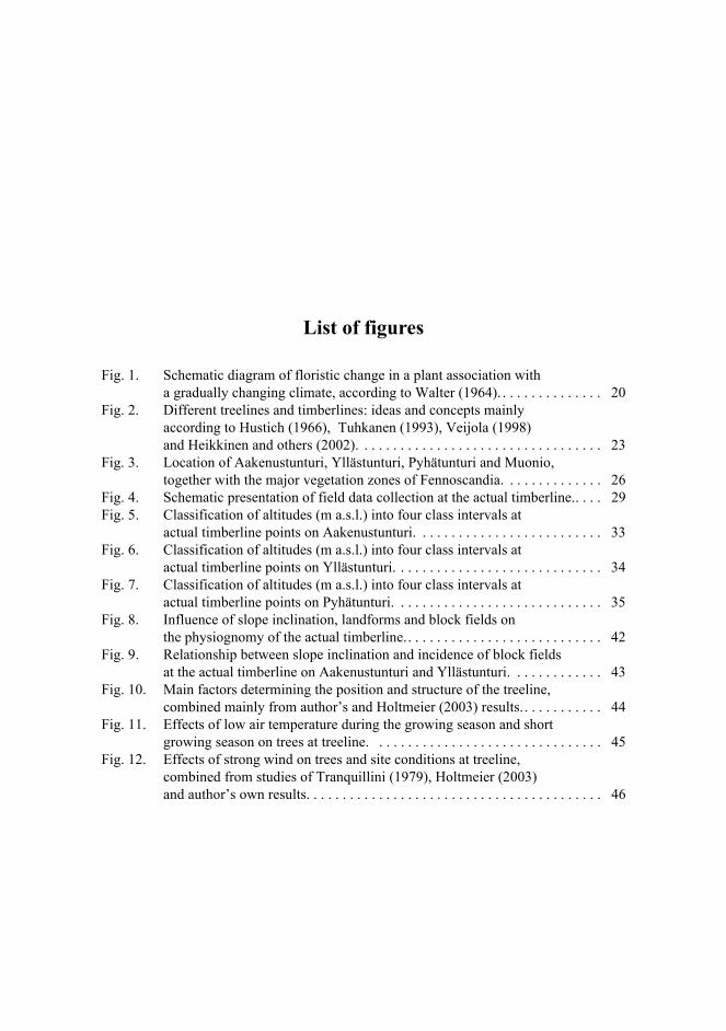
Forest cover may gradually become thinner with increasing altitude, in a manner simi-lar to the case of continuum theory (Whittaker 1956, Walter 1964), so that it is difficult todistinguish the vegetation types from each other (Fig. 1, line B). In this case, the actualtimberline does not form any easily distinguishable or delineable line that can be per-ceived in the terrain or on aerial photographs. On the other hand, it may be abrupt, border-ing on a treeless or almost treeless area in the landscape. This is similar to line D in thecontinuum theory, as shown in Figure 1, where the vegetation types form a distinguish-able flat growth zone. Sometimes an actual timberline suggestive of the case line C inFigure 1 is to be found in Finnish Lapland. It is always possible to define the uppermostlimit of continuous forest, in contrast to the total continuum of the continuum theory (Fig.1, line A).
The timberline has fascinated researchers for about 200 years. The earliest reports, inwhich the focus was on observing its altitudinal position, appeared about 200 years ago(Zschokke 1805, cit. Holtmeier 2003). Early timberline research was reviewed by Däni-

20
ker (1923), who first studied this phenomenon with special regard to ecological condi-tions and who was the first to use ecological research methods (Tranquillini 1979,Tasanen & Veijola 1994, Holtmeier 2003), although some studies on ecological condi-tions at the timberline were carried out also before Däniker (1923), such as the mono-graph of Kihlman (1890) on the northern tree line on the Kola Peninsula. Those studieswere based on careful observations and considerations, but not on experimental ecologi-cal measurements. Proposals have been appearing in the scientific literature for more thana hundred years concerning the climatic parameters and indices that best denote the loca-tion of the timberline and treeline (Tuhkanen 1984, 1999). Supan (1884) and later Köppen(1919) emphasized at an early stage the conspicuous coincidence of the polar treeline andtimberline with the 10oC isotherm for the warmest month of the year, which is the oldestand best-known climatic indicator for these limits.
Fig. 1. Schematic diagram of floristic change in a plant association with a gradually changingclimate, according to Walter (1964).
The timberline and treeline are influenced by many abiotic (climatic, edaphic andtopographic), biotic (parasitic snow fungi, insect pests, other animals) and anthropogenicfactors (felling, grazing, air pollution, fire), which are often interrelated in a complex way(Holtmeier 2003). There is a firmly established conception among timberline researchers,however, that climate is the main factor primarily controlling the general position of tim-berlines and treelines in polar and mountain regions (Hustich 1948, Tranquillini 1979,Wardle 1993), just as it acts as the main factor governing the distribution of vegetation onthe Earth as a whole (Tuhkanen 1984). Air temperature has generally been considered themain climatic factor determining both the altitudinal and northern timberline and treeline(Tranquillini 1979, Larsen 1989, Dahl 1998, Tuhkanen 1999). The impact of thermal fac-
A
B
C
12
34
5
12
34
5
Climatic change
Continuum, not possible to distinguish
plant associations
Gradually changing plant associations (1-5)
Abruptly changing plant associations (1-5)
1
23
45
D
Rather abruptly changing plant associations (1-5)

21
tors on the formation of the timberline and treeline or on trees growing there has beenstudied widely (Hustich 1948, 1952, 1966, 1983, Sarvas 1970, Perttu 1972, Skre 1972,Holtmeier 1974, 2003, Tranquillini 1979, Kullman 1981, 1992, 1997, Dahl 1986, Wood-ward 1988, Nikolov & Helmisaari 1992, Slettjord 1993, Tuhkanen 1993, Norokorpi 1994,Autio 1995a, Mook & Vorren 1996, Odland 1996, Kellomäki et al. 1997), while wind as aregulating factor has been studied by Perttu (1972), Tranquillini (1979), Hadley andSmith (1983, 1989), Robertson (1993), Wardle (1993), Sirén (1994), Kullman (2001) andHoltmeier (2003). The important role of the snow cover and its properties and durationhas similarly been studied extensively (Holtmeier 1974, 2003, Tranquillini 1979, Arno1984, Kullman 2001), and the damage inflicted by heavy snow loads, i.e., the combina-tion of ice, rime and snow on trees, and its influence on the altitude of the timberline hasbeen studied by Heikinheimo (1920), Norokorpi and Kärkkäinen (1985), Norokorpi(1994) and Heikkinen and others (2002). The consequences of the predicted global cli-mate warming on the formation of heavy, ice-packed snow have been discussed by Jal-kanen and Konôpka (1998). Radiation parameters such as annual global net radiation andnet radiation during the growing season (Ritchie 1960) are associated with the position ofthe boreal and arctic vegetation zones, and the location of the timberline has also beenexplained in terms of air mass climatology (Bryson 1966). The position of the arctic frontin summer closely coincides with the northern timberline in Eurasia and Canada (Mitchell1973, Larsen 1974, Tuhkanen 1999).
Sometimes the timberline is unable to reach its climatic limit, in which case its loca-tion may be regulated more obviously by locally varying orographic (Hustich 1937,Piirola 1967, Holtmeier 1974, 2003, Tranquillini 1979, Autio 1995a, 1995b, Holtmeier etal. 2003) and topographic (Perttu 1972, Arno 1984, Mayer & Ott 1991, Autio 1995a,1995b, Kjällgren & Kullman 2002, Holtmeier 2003) factors than by climatic factors.Also, soil temperature has proved to be just as important as air temperature as a control-ling factor (Holtmeier 2003), and anthropogenic and biotic factors have been shown tolower the altitudinal position of the timberline (Holtmeier 1974, 2003, Veijola 1998).
Despite the long tradition of timberline research, there is still no uniform theory thataccounts for it exhaustively, and there is still an evident need to investigate the timberlineand treeline, especially with respect to its local levels (horizontal distribution 100 m – 1km) and regional levels (horizontal distribution 1 – 100 km) (Holtmeier 2000, 2003,Kjällgren & Kullman 2002). In the case of Central Finnish Lapland, for example, the areabetween the parallels 67oN and 68oN, no highly accurate local or regional picture is avail-able on the relation between climatic, orographic or topographic factors in determiningthe location of timberline and treeline. The purpose of the present work is to remedy thisinsufficiency.
1.1 Timberline and treeline definitions and terminology
An operational definition of timberline and treeline is often needed (Tuhkanen 1993).Most definitions of the timberline refer to a certain minimum forest cover and those ofthe treeline to a minimum tree height (Holtmeier 2003). The critical minimum cover mayrange from 30 to 40% (Holtmeier 1974, Ellenberg 1986, Påhlsson 1995) and the mini-

22
mum tree height may range from two to three metres (Wardle 1974, Kullman 1979, 1990,Holtmeier 2003).
The terms related to the timberline, i.e., the transitional zone between forested andtreeless areas, are numerous and rather ambiguous (Hustich 1966, 1979, Heikkinen 1984,2005, Tuhkanen 1993, 1999, Autio 1995b, Heikkinen et al. 2002, Holtmeier 2003), onaccount of the great ecological, physiognomic and taxonomic variety of mountain timber-lines (Tuhkanen 1993, Holtmeier 2003) and multidisciplinary and multilinguistic natureof the subject matter (Tasanen & Veijola 1995). Some terms refer to the location of thetimberline (upper, lower timberline), others are related to factors controlling it (climatic,orographic, anthropogenic timberline) and others refer to both location and causes(alpine, northern, continental, maritime timberline). Proposals for the standardization ofthe nomenclature have been made (Löve 1970, Hustich 1979), but the generally acceptednomenclature is far from complete (Hustich 1966; Atkinson 1981, Payette 1983, Kull-man 1990, Tuhkanen 1993, Holtmeier 2003). It seems that there are almost as many defi-nitions as there have been researchers working with timberlines, and it is certainly thecase that traditions regarding timberline terminology differ from one country to another(Tuhkanen 1999). It is nevertheless obvious that an abundant terminology and range ofconcepts is needed so that the phenomenon can be discussed accurately.
One of the most widely used sets of timberline terminology is that suggested by Hus-tich (1966, Fig. 2), more detailed descriptions of which are presented in paper III. Thishas been used later by many others to define the physiognomic forest line (Heikkinen1984, Tuhkanen 1993, Autio 1995b, Heikkinen et al. 2002) or the physiognomic timber-line (Veijola 1998) as that represented by the limit of continuous or nearly continuous for-est cover bordering on a treeless or almost treeless fell summit. Since this line is more orless clearly distinguishable in the landscape, it is also known as the empirical (Dahl 1998)or actual timberline (Lauer & Klaus 1975, Dahl 1998, Veijola 1998, Holtmeier 2000,2003). As far as the altitudinal limit of forest is concerned, the concepts of upper timber-line and alpine timberline are used, too (Tuhkanen 1999, Holtmeier 2003, Heikkinen2005), although these are not very coherent concepts in the case of Finland, which has nolower timberlines, for example, to the counterpart of the upper timberline. This may thecase in spite of the fact that the upper timberline may be a consequence of the same effectthat brings about the lower timberline, e.g., a cold air lake (Whiteman 2000) and formsthe front for the actual timberline (III). For this reason altitudinal timberline (see Kull-man 1990, Barnekow 1999) would be a more neutral and applicable term than upper tim-berline. The word alpine is closely associated with the Alps and high-mountain regions,and is therefore not entirely accurate for describing the low, rounded fells of NorthernFinland (Heikkinen 2005). Since the term alpine should, according to Holtmeier (1974),be defined as applying only to the Alps, maybe fell timberline would be more logical touse in Fennoscandia. There are several reasons why it was decided here to use the termactual timberline to describe the limit of continuous or nearly continuous forest cover bor-dering on a treeless or almost treeless fell summit. Firstly, actual timberline is more com-mon and customary than physiognomic or empirical timberline. Secondly, the word actual(Hustich 1979) literally means the present limit of continuous forest, which reflects theimportance of prevailing environmental conditions such as climate together with the sitehistory (Holtmeier 1997, 2002), thus alluding to the changing nature of the timberline intime and space, i.e., it is dynamic. Thirdly actual also means distinct; the actual timberline

23
is a more and less conspicuous phenomenon in the visible landscape, either abrupt orgradual. Fourthly, it doesn’t refer to any particular controlling factor; on the contrary, theactual timberline is a result of many unfavourable factors, as is a typical feature in moun-tain areas. In contrast to the present author, Holtmeier (2003) uses the term actual timber-line to refer to a limit resulting from factors other than climate. Actual timberline willnevertheless be used here as a generic term for more or less continuous forests borderingon treeless or almost treeless fell summits whatever their causes.
The transitional zone between the economic timberline and the tree-species line iscalled the timberline ecotone (Fig. 2) (Heikkinen et al. 2002, III, IV). When the historicalaspect, the changing nature of the actual timberline in time and space, is included, thisecotone could be extended as far as the historical timberline. The transitional zonebetween the actual timberline and the treeline, characterized by isolated trees and smallstands, even forest patches, is called the treeline ecotone (Holtmeier et al. 2003). Thetreeline itself is the extreme boundary where trees still achieve arboreal form and size (2m) (Hustich 1966, Tuhkanen 1993). Since the area between the remote individual trees iscompletely treeless, it may be said that the treeline ecotone is relatively treeless and anopen fell summit is completely treeless (see Krujkov 1993, cit. Tasanen & Veijola 1995),with only crippled growth forms of tree species existing, e.g., mat forms.
Fig. 2. Different treelines and timberlines: ideas and concepts mainly according to Hustich(1966), Tuhkanen (1993), Veijola (1998) and Heikkinen and others (2002).
Limit for the extreme outposts of a tree speciesduring earlier, more favourable climatic stages
Limit for the occurrences of a tree speciesTree species appear in any growth forms (krummholz, flag- and mat forms)
Limit for the extreme tree-like occurrences of a tree species
Trees grow in clumps or individually in favourable soil and exposures
Limit for continuous forest
Natural regeneration is slow and unsure
Tree regeneration is active. Timber cuttings are possible
HISTORICTREELINE
TREE-SPECIESLINE
TREELINE
ACTUALTIMBERLINE
ECONOMICTIMBERLINE
TIM
BER
LIN
E E
CO
TON
E
TREELINEECOTONE

24
1.2 Aims of the research
The main questions considered in the present research are:1. What are the altitudinal positions of the actual timberline and treeline? (IV)2. What are the special characteristics of the local climate in the timberline ecotone? (I,
II, III)3. What factors control the position and formation of the actual timberline? (III, IV)4. What factors control the position of the treeline? (III, IV)5. What is the relationship between local climate conditions and pollen deposition at the
timberline ecotone? (II)6. What is the potential for actual timberline and treeline advance? (III, IV)

2 Material and methods
2.1 The area studied
The field studies were carried out on the fells of Aakenustunturi, Yllästunturi and Pyhä-tunturi, situated between 67oN and 68oN in Finnish Lapland (Fig. 3). The area lies withinthe northern boreal vegetation zone in the system of phytogeographical zones (Ahti et al.1968) and sectors for north-west Europe, lying in sector OC, which is indifferent in termsof continentality/oceanity (Tuhkanen 1984, Hämet-Ahti 1988). General characterizationsof the climate of northern Finland and the fell climate are presented in paper I anddetailed climate characterizations of Aakenustunturi in papers II and III.
The fells belongs to one of the most ancient residual mountains in the world, some ofits rocks being around 2000 million years old (Manner & Tervo 1988). Most of the rock isquartzite (Mielikäinen 1979, Rastas 1984), with a high resistance to chemical weather-ing. Angular quartzite blocks have been pried apart by water that freezes in the cracks attheir joints, forming wide fields of frost-shattered boulders. The round summits of thefells display patterned ground and block streams formed on a till containing local quartz-ite (Autio & Kinnunen 1992, McCarroll et al. 1996). The fells are characterized by geo-morphological landforms such as lateral meltwater channels and glaciofluvial overflowchannels (IV). Orographic and topographic influence on the position of the actual timber-line is discussed in paper IV. Human activity is confined to occasional visitors on Aake-nustunturi and in the areas of Yllästunturi and Pyhätunturi that are not reserved for down-hill skiing. Ylläs, the westernmost summit of Yllästunturi, and Pyhäkero, the easternmostsummit of Pyhätunturi, are important winter resorts, with downhill skiing slopes that arevisible in all directions over an area of dozens of kilometres in summertime (Ukkola1995, Autio 1997).

26
Fig. 3. Location of Aakenustunturi, Yllästunturi, Pyhätunturi and Muonio, together with themajor vegetation zones of Fennoscandia: OA – oroarctic, NB – northern boreal, and MB – mid-dle boreal (Ahti et al. 1968).
2.2 Field studies
Summary of the data used in the present work is described in Table 1.

27
Table 1. Summary of the data used in the present work.Data type Observation
periodObservation site Data
analyserUsed technique/instrument/data source
Air temperature at a 2.0 m above the ground
Eight growing seasons (1994–2001) and con-tinuously 1.3.1996–28.2.1998
4 sites on Aakenustun-turi
Jyrki Autio Data logger, model KM1420
Reference air temper-ature data
Normal period 1961–1990
4 sites on Aakenustunturi
Jyrki Autio Program of Ojansuu & Henttonen (1983)
Air temperature at a 0.1 m and 0.3 m above the ground
Summer 1997 3 sites on Aakenustunturi
Jyrki Autio Data logger, model KM1420
Soil temperature at a 0.1 m below the ground
1.3.1996–28.2.1998 and summer 1998
3 sites on Aakenustunturi
Jyrki Autio Data logger, model KM1420
Snow depth and duration
1994–1998 9 sites on Aakenustunturi
Jyrki Autio Depth gauge
Delayed snow depos-its
1998 Aakenustunturi Jyrki Autio Digital aerial photographs by FM-kartta Oy
Heavy snow load damage to spruce and pine
2000 Aakenustunturi and Yllästunturi
Jyrki Autio Estimated from the sample plot size of 400 m2 at the actual tim-berline
Wind direction and velocity
Growing sea-sons 1994–2001
Muonio (1994–2001) Yllästunturi (1994–1999)
Jyrki Autio Muonio (Finnish Meteo-rological Institute)Yllästunturi (Digita Oy)
Actual timberline position
2000 and 2001 Aakenustunturi, Ylläs-tunturi, Pyhätunturi (total number of plots is 787)
Jyrki Autio Uppermost limit where canopy achieve c. 30% (sample plots size 400 m2) coordinates recorded on a GPS
Actual timberlineelevation
2000 and 2001 Aakenustunturi, Ylläs-tunturi, Pyhätunturi (787 plots)
Alfred Colpaert
ArcGis program and elevation model by National Land Survey
Treeline 1989, 1990 and 1993(Autio 1997)
Aakenustunturi, Ylläs-tunturi, Pyhätunturi
Jyrki Autio Uppermost limit where trees achieve arboreal form and size (2 m)
Actual timberline exposure
2000 and 2001 Aakenustunturi, Ylläs-tunturi, Pyhätunturi (787 plots)
Jyrki Autio Method by Perttu (1972)
Slope inclination at the actual timberline
2000 and 2001 Aakenustunturi, Ylläs-tunturi (787 plots)
Jyrki Autio Hypsometer, model PM-5/1520
Thickness of humuslayer and soil type
1989 (Autio 1997) and 1994
Pyhätunturi (1989) and Aakenustunturi (1994)
Jyrki Autio grain-size analysis
Seedling density andmortality
2004 15 sites on Aakenustunturi
Jyrki Autio Number of seedlings on sample plots (size 300m2/500m2)
Pollen deposition 1996–2001 4 sites on Aakenus-tunturi
Sheila Hicks and Raija-Liisa Huttunen
Tauber trap

28
2.2.1 Air and soil temperature
Air temperature measurements were carried out in the closed forest near the economictimberline (330 m a.s.l.), the actual timberline on the northern slope (390 m a.s.l.), thetreeline (482 m a.s.l.) and the actual timberline on the southern slope (430 m a.s.l.) alonga south-to-north transect across Aakenustunturi. The sites on the actual timberlines weresituated close to the climatic forest limit in each case (III, IV). At each site air tempera-tures were measured at one-hour intervals by means of four-channel data loggers, modelKM 1420, at a standard height of 2.0 metres above the ground surface. The temperaturesensors were fitted with white plastic covers with ventilation slits to interrupt direct solarradiation. The measurements covered the summer periods of eight years, 1994–2001 (II,III), in addition to which year-round measurements were taken throughout the periodfrom 1st March 1996 to 28th February 1998 (I, III). The vertical distributions of air tem-peratures at heights of 2.0, 0.3 and 0.1 metres above the ground surface and 0.1 metresbelow the ground surface in summer 1997 are presented in paper III.
Monthly mean temperatures and effective temperature sums for the normal period1961–1990, calculated using the model of Ojansuu and Henttonen (1983), were used asreference data (II, III). The measured and calculated data were a quite similar, althoughthe monthly mean temperatures deduced from the model values were usually lower thanthose for the measurement site at the actual timberline on the southern slope (II). Calcula-tions and definitions of biotemperature, July mean and July mean maximum tempera-tures, mean tetratherm, maximum and minimum tetratherms, mean tritherm, effectivetemperature sum, effective temperature sum minimum and length of growing season areprovided in paper III.
Soil temperatures at a depth of 0.1 metre were measured at one-hour intervals at theactual timberline on the northern slope, the treeline and the actual timberline on the south-ern slope at Aakenustunturi all the year round for the period 1.3.1996–28.2.1998, and soiltemperatures were measured in summer 1998 (III). Soil and air temperatures were moni-tored using the same data loggers.
The accuracy of the data logger model at reference temperatures of -100oC to 300oC is±0.2oC (KM1400 Series 1989), and the accuracy of the instruments was re-tested at refer-ence temperatures of -40oC to +40oC during calibration, where it was found to be ±0.1oC,i.e., at least as good as data loggers such as Tiny-Talk (Data Logger… 2005) and Ham-ster (Elpro 2005), as used by Mook and Vorren (1996) and Vorren and others (1999).
Missing temperature readings for the treeline station in 1995 were filled in using lin-ear regression based on data for the adjacent actual timberline station during the sameperiod. The square of the correlation (R2) in the regressions ranged between 0.945 and0.977.
2.2.2 Snow depth and duration, wind direction and velocity
Snow depths were recorded over the period 1994–1998 at nine sites at different altitudesalong the south-north transect on Aakenustunturi (III). Digital aerial photographs wereused to illustrate the relation between lingering snowpatches and the position of the actual

29
timberline (IV). Some observations on snowpatches are also included in paper I. Heavysnow load damage to the spruce and the pine were estimated (see Norokorpi & Kärkkäi-nen 1985) from circular monitoring plots of size 400 m2 (radius 11.5 m) bordering on theactual timberline (Fig. 4) and the influence of these factors on the altitude of the actualtimberline was assessed (IV).
Wind directions and velocities were estimated on the basis of data available from theFinnish Meteorological Institute’s observation station at Muonio (254 m a.s.l.) and thesummit of Yllästunturi (718 m a.s.l.) (II, III).
Fig. 4. Schematic presentation of field data collection at the actual timberline. Black dots il-lustrate sites where the canopy of the continuous or almost continuous forest is still c. 30 % andwhere the altitudinal position of actual timberline was recorded on GPS receiver. The propor-tion of canopies, tree species and snow load damage to spruce and pine were estimated from cir-cular monitoring plots of size 400 m2 (radius 11.5 m) bordering on the actual timberline. Theextents of block or boulder fields were measured by estimating their percentual coverage of therectangular sample plots of size 400 m2. Slope inclination has measured exactly at the actualtimberline (black dots).
2.2.3 Actual timberline position and elevation
The actual timberline was drawn along the line where the crown canopy of the continu-ous or almost continuous forest was still c. 30% (Holtmeier 1974, Påhlsson 1995). Deter-minations were made on at 367 sites Aakenustunturi and 76 sites on Yllästunturi,employing a selection strategy in which a sampling site was declared whenever a changewas observed in the altitudinal position of the actual timberline. Other factors measured
Treeline
Actual timberline
Increasing altitude
Treelineecotone
Fell heath

30
at the same sites were exposure and slope inclination. Presence and cover of block fieldsmeasured just above the actual timberline. Whereas amount of snow damage to spruceand pine and proportions of the tree species were measured just below the actual timber-line (Fig. 4). Exposure and the location of the actual timberline were measured at a totalof 344 sites on Pyhätunturi. The coordinates (lat, long) of all the sites were recorded on aGPS receiver, model GARMIN GPS 12XL, employing the average position function,which means that the GPS receiver calculates moving averages of the coordinates andmeasurement is continued until this moving average stabilises, which takes approximate-ly five minutes (Owner’s manual & reference 1998). The accuracy of the position wasfive to ten metres on average. The elevations of the actual timberline sites were deter-mined using the overlay analysis technique in the ArcGis program and elevation modelsprovided by the National Land Survey. By combining the line connecting the actual tim-berline sites with digital aerial photographs it was possible verify the accuracy of theactual timberline altitudes whenever they coincided with the lower edges of block fields(IV). In addition, digital aerial photographs were used to illustrate the relation betweenthe actual timberline and environmental factors that lower or raise its position. Treelinealtitudes are based on the data published by Autio (1997).
2.2.4 Topography and orographic features
Slope inclination (in degrees) at the actual timberline was measured using an optical hyp-someter, model PM-5/1520. The orientations of the actual timberline sites were estab-lished in relation to the nearest fell summit. The fell were divided into four sectors, eachstanding for one cardinal point, with the half-cardinal points serving as sector bound-aries, the final exposure of each timberline site then being determined on the basis of thecardinal point of the sector in which the target was situated (IV) (see Perttu 1972).
The extents of block or boulder fields were measured by estimating their percentualcoverage of the land area (400 m2) at the actual timberline (IV, Fig. 4). The thicknesses ofthe humus layers and soil types were measured at the sites used for the air temperatureobservations (III).
2.2.5 Pollen deposition and seedling density
Annual variation in pollen deposition was measured during the period 1996–2001 bymeans of Tauber traps placed at exactly the same spots on the transect across Aakenus-tunturi as were used for the air temperature measurements. The pollen results areexpressed as annual pollen deposition (grains cm-2 year-1) (II).
Seedling density (number of height < 2 m/ha) and mortality (number/ha) were moni-tored for spruce and pine separately on Aakenustunturi at points immediately above theactual timberline and in the middle of the treeline ecotone on the southern and northernslopes and at the treeline. The total number of plots used was 15. At the actual timberline

31
plots had an area of 300 m2 (radius 9.8 m) and those in the middle of the treeline ecotoneand at the treeline had an area of 500 m2 (radius 12.5 m) (IV).
2.3 Statistical analysis
Non-parametric statistical analyses were used, because the materials did not follow thenormal distribution, which was always checked before application of the Kolmo-grov-Smirnov test (SPSS Base 8.0 1998). Spearman correlation analysis was used toexamine the direction and intensity of the connection between pollen deposition and thevarious temperature indicators, i.e., mean monthly temperature and mean monthly effec-tive temperature sum, two-week mean temperature and cumulative effective temperaturesums for the current and previous summer (II). Spearman correlation was also used tostudy the direction and intensity of the correlation between the altitudes of the actual tim-berline, coverage of block fields, slope inclination and snow damage to spruce and pine(IV).
The altitudes of the actual timberlines with different exposures were analysed with thenon-parametric Mann-Whitney’s U test to test the null hypothesis that the groups of sitesdefined for the four points of the compass would be at equal altitudes (IV). Mann-Whit-ney’s U test was also used to test the null hypothesis that air and soil temperatures wouldbe identical (III).

3 Results and discussion
The results are described in detail in original papers I–IV.
3.1 Altitudinal positions of the actual timberline and treeline
The average actual timberline elevation varies from ca. 370 metres to 400 metres a.s.l.The lowest vertical forest limit lies at approximately 270 m a.s.l., and the highest continu-ous forest reaches almost 460 m a.s.l. The difference between the highest and lowest alti-tudinal positions of the actual timberline on Aakenustunturi and Yllästunturi is greatest atthe northern exposure but on Pyhätunturi at the southern exposure (III).
The effect of exposure is significant on the altitude of the actual timberline, which isusually highest on the west and south-facing slopes (Figs. 5, 6, 7) and lowest on the northand east-facing slopes. In some cases, however, the altitude of the actual timberline mayremain significantly lower than average even on south-facing slopes, as on Pyhätunturi(Fig. 7), where it is affected by very steep and very rocky slopes (IV).
The average altitudinal position of the treeline is highest on south-facing slopes (473 ma.s.l.) (Autio 1997), where the most favourable thermoclimatic conditions are prevailing(I, II, III), while on north-facing slopes the average altitudinal position of the treeline is450 m a.s.l. The maximum height of the treeline, 516 m a.s.l., is reached on the south-fac-ing slope of Yllästunturi (Autio 1997).

33
Fig. 5. Classification of altitudes (m a.s.l.) into four class intervals at actual timberline points onAakenustunturi. The number of actual timberline points (circles of different colours) for eachinterval class is also given in parentheses. Contours are presented at 10-metre intervals.
21
kilometres
0
Z
Z
Z
ZZ
Z
Z
Z
ZZ
Vasalaki 460
430
Vaulokuru
M oloslaki 530M oloslaki 530M oloslaki 530M oloslaki 530M oloslaki 530M oloslaki 530M oloslaki 530M oloslaki 530M oloslaki 530
Vareslaki 485Pallilaki 570
Pallikuru (
67° 39' 04"
24° 23' 44"24° 23' 44"24° 23' 44"24° 23' 44"24° 23' 44"24° 23' 44"24° 23' 44"24° 23' 44"24° 23' 44"
Altitudes of the actual timberline ( m a.s.l.)
402 - 440 (75)363 - 401 (161)324 - 362 (89)284 - 323 (42)

34
Fig. 6. Classification of altitudes (m a.s.l.) into four class intervals at actual timberline points onYllästunturi. The number of actual timberline points (circles of different colours) for each in-terval class is also given in parentheses. Contours are presented at 10-metre intervals.
67° 33' 10"
(((((((((24° 10' 16"
Keskinenlaki 610
Kellostapuli
502.7
Ylläs 718.5
Varkaankuru
Z
Z
Z
222222222
kilometreskilometreskilometreskilometreskilometreskilometreskilometreskilometreskilometres
111111111000000000
Altitudes of the actual timberline ( m a.s.l.)
410 - 456 (31)364 - 409 (30)318 - 363 (8)272 - 317 (5)
502.7

35
Fig. 7. Classification of altitudes (m a.s.l.) into four class intervals at actual timberline points onPyhätunturi. The number of actual timberline points (circles of different colours) for each in-terval class is also given in parentheses. Contours are presented at 10-metre intervals.
3.2 Character of the local climate in the timberline ecotone
3.2.1 Temperature
Fell summits are colder on average than areas situated at lower altitudes (I, II, III),because in the standard atmosphere a hundred-metre rise in altitude will bring about atemperature decrease of 0.65oC (Gregg 1949) and high winds will also lower mean tem-peratures (Tranquillini 1979). The lapse rate of the mean annual temperature deducedfrom the values observed on Aakenustunturi is much greater between the actual timber-lines and the treeline than between the closed forest and the treeline, especially on thesouth-facing slope (Table 2) (see Mook & Vorren 1996). The drop in mean annual tem-perature with height between the closed forest and treeline is almost the same as in thestandard atmosphere (Table 2; III). The lapse rates of the other temperature indicators thatmay be regarded as serving best to explain the location of the actual timberline and
67° 00' 25"
Peurakuru
Peurakero 504
(27° 04' 35"
Z
kilometre
10.50
Altitudes of the actual timberline (m a.s.l.)
410 - 435 (97)385 - 409 (210)360 - 384 (28)335 - 359 (9)

36
treeline behave with increasing altitude in the same way as the mean annual temperature(III). The observations also show that the lapse rates vary seasonally (Table 2, I), a situa-tion also noted elsewhere (Yoshino 1975). Despite the fact that the lapse rate varies withexposure, season and height in a standard atmosphere, it is often used in vertical extrapo-lation of temperatures from official weather stations due the lack of in situ temperaturemeasurements in mountain areas (Mook & Vorren 1996, McKenzie et al. 2003), especial-ly in timberline environments (Tuhkanen 1999).
Table 2. Lapse rates (°C/100m) of mean monthly temperatures measured at a height of 2 mabove ground between the monitoring sites CF (330 m a.s.l., closed forest near the econo-mic timberline) to TL (482 m a.s.l., treeline), ATLN (390 m a.s.l., actual timberline on thenorth-facing slope) to TL and ATLS (430 m a.s.l., actual timberline on the south-facingslope) to TL on Aakenustunturi. Values are 4-year means (1.8.1994–31.7.1998).
The highest July absolute maximum temperatures measured at the actual timberlineare always higher than at the treeline and nearly always higher than in the closed forest.The number of hot days (daily maximum temperature +25oC or more) during the period1994–2001, for example, was 59 at the actual timberline on the southern slope, 35 at theactual timberline on the northern slope, 29 in the closed forest and 18 at the treeline. Tem-poral and spatial variations were observed in the distribution of temperature stratificationwithin the lowest 2 m of the air mass, in that temperatures near the ground surface wereseveral degrees higher than at 2 m in the middle of the day at the actual timberline on thesouthern slope and in the afternoon at the actual timberline on the northern slope. Temper-atures could be relatively high at night as well at the actual timberline on the northernslope in summer (III). Actual timberlines on south-facing and north-facing slopes withinclinations of 10–15° usually receive more solar radiation than more gentle (2°), forestedslopes (Geiger et al. 1995; Whiteman 2000). In the present case the most extreme temper-ature conditions are to be found at the actual timberline on the southern slope (Autio1995a, 1995b, Autio et al. 1998, II, III).
Temperature inversions (Huovila 1987, Tammelin 1988, Whiteman 2000) are encoun-tered particularly in winter and can be of over three days’ duration (I, III). When a fellsummit is situated about 500 m a.s.l., the greatest temperature difference between thelowest-lying place, the closed forest, which is also the coldest place, and the fell summit,the warmest place, can be as much as 16°C. The top of the inversion is nearly always onthe summit among fells where the highest point does not reach more than 500 m a.s.l.(III), but on fells of high altitude, such as Yllästunturi (718 m a.s.l.), the top lies some-where in the middle of the slope, near the actual timberline (Kurula & Heikkinen 1996).On the other hand, it must be remembered that the height of the top of an inversion varieswith the season of the year (Tammelin & Säntti 1992). The observations from Aakenus-tunturi show, for example, that the top of the inversion sometimes lies at the actual tim-
Site to site Differencein height
(m)
Jan Feb Mar Apr May Jun Jul Aug Sep Oct Nov Dec Year
CF to TL 152 0.84 0.51 0.79 0.69 1.20 0.92 0.80 0.33 0.30 0.91 0.20 0.18 0.64
ATLN to TL 92 0.98 0.47 0.71 0.49 1.03 0.79 1.10 0.33 0.71 0.65 0.58 0.90 0.73
ATLS to TL 52 0.73 0.58 1.40 0.83 1.83 1.73 1.90 1.10 1.44 0.58 0.77 0.63 1.10

37
berline on the south-facing slope (430 m a.s.l.), especially in early winter (I, III). Rapidtemperature fluctuations are typical during temperature inversions (III). Inversions ofshorter duration, less infrequent and less pronounced than in winter, were also observedduring the growing season, mostly in the night and early morning, at which time the coldair slid down the slope, coming to rest in the area just above the actual timberline, whereit caused a cold air lake (Tammelin 1988, Whiteman 2000), thus exposing this area to thedanger of night frost. Small-scale temperature inversions are also quite common close theground surface on cold summer nights, being most obvious at the actual timberline, inwhich case temperatures below 0oC are recorded just above the ground surface while thetemperature is above 0oC at a height of 2 m (III). At the treeline, however, the air temper-ature is more or less the same near the ground surface and at 2 m.
Orographically caused exposure to night frosts is more common at the treeline than atlower altitudes, i.e., at the actual timberline or in closed forests, at the beginning of thegrowing season, and the late spring and early summer are much colder at the treeline thanin lower lying places. By contrast, night frosts occur most commonly at the actual timber-line on southern slopes and least at the treeline at the end of the growing season, inAugust and September (III).
The observations show that the mean minimum tetratherm (+6.3°C, cf. Slettjord 1993),mean July temperature (+12.6°C, Norin 1978, cit. Tuhkanen 1993), biotemperature (+3.3°C,cf. Tuhkanen 1980) and minimum effective temperature sum (455.4 d.d., cf. Nikolov &Helmisaari 1992) on the treeline coincide with the results of earlier studies, while the meantetratherm (+10.3°C and +10.1°C, respectively) at the actual timberline on the southern andnorthern slopes, together with the mean maximum tetratherm (+15.4oC, cf. Mook & Vorren1996) on the southern slope coincide with the results of earlier studies. In practice the meanlength of the growing season is c. 118 days both at the actual timberlines on the southern andon the northern slopes. This is 6 days longer than at the treeline. The growing seasonbecomes shorter by 5 days per 100 m between the closed forest and treeline, but the shorten-ing is more pronounced between the actual timberline and treeline. The mean effective tem-perature sum at the actual timberline on the southern slope is 704 d.d., which is c. 27 d.d.higher than on the northern slope and c. 85 d.d. higher than on the treeline (III). The ther-moclimatic indicators calculated from the observed values and from the climate model ofOjansuu & Henttonen (1983) for the actual timberlines and treeline (Table 3) were mostlyhigher than in earlier studies (III).

Table 3. 8-year (1994–2001) and 30-year (1961–1990) means (the latter calculated using the m
odel of Ojansuu and H
enttonen 1983) oftherm
oclimatic indicators m
easured at a height of 2 m above ground at the m
onitoring sites CF (330 m
a.s.l., closed forest near the econo-m
ic timberline), ATLN
(390 m a.s.l., actual tim
berline on the north-facing slope), TL (482 m a.s.l., treeline) and ATLS (430 m
a.s.l., actualtim
berline on the south-facing slope) on Aakenustunturi.
Year Site
JulyM
ean
°C
JulyM
ean m
ax°C
JulyM
ean m
in°C
TetrathermM
ean
°C
Tetrat.M
ean m
ax°C
Tetrat.M
ean m
in°C
TrithermM
ean°C
TrithermM
eanm
ax°C
TrithermM
eanm
in°C
Biotem
p.
°C
Grow
ingseason days
Effectivetem
p. sumd.d.
8-year m
ean C
F13.5
17.89.3
10.214.2
6.411.8
16.17.6
3.7120.1
698.3ATLN
13.318.0
9.210.1
14.36.4
11.616.2
7.63.6
118.5677.1
TL12.6
16.28.7
9.413.0
6.310.9
15.07.3
3.3112.5
619.4ATLS
13.518.6
8.810.3
15.16.1
11.817.0
7.33.7
118.3704.0
30-year m
ean
CF
13.29.9
11.53.7
690.0ATLN
13.09.6
11.23.6
663.0
TL12.6
9.210.8
3.4613.0
ATLS
12.9
9.5
11.1
3.5
644.0
38

39
The period for which air and soil temperature measurements were carried out waslonger and the network more extensive in this case than in any other study of timberlinesand the treeline undertaken in Finnish Lapland (III). Thermoclimatic characterizations ofthe timberline ecotone and the effects of climate on the formation of timberlines andtreelines in northern Norway (e.g. Mook & Vorren 1996) and in Sweden (Perttu 1972) arealso usually based on shorter time series than this. The sparseness of representativerecords of air temperatures (Tranquillini 1979, Mook & Vorren 1996, Tuhkanen 1999,McKenzie et al. 2003) and soil temperatures (Holtmeier 2003) in the timberline ecotonetogether with the indeterminacy of the concept of timberline and its highly variable natureboth physiognomically and taxonomically create difficulties in comparing the presentresults with earlier ones.
3.2.2 Snow cover
The depth of the snow cover on fells varies greatly on account of altitude, exposure, the veg-etation cover, land surface structure and roughness, i.e., microtopography and geomorphiclandforms, wind direction and velocity (III, Holtmeier 1974, 2003). The depth continues toincrease above the actual timberline, but eventually decreases towards the fell summit,where the maximum depth will be less than 0.3 m. There are also places, usually convexsurfaces, where no snow accumulates at all because the wind blows it away. Reindeer graz-ing also left some snow-free places behind on the fell summit in the present case. The larg-est amount of snow, c. 4.0 m, accumulated in lateral meltwater channels near the actual tim-berline on the north-facing slopes (I, III), where the snow patches usually persist until theend of July each year. The convex microtopography on the fell summits and the sun-exposedslopes of the meltwater channels usually become clear of snow during April, at which timethe maximum depth of snow, 1.65 m, is to be found in front of the actual timberline. Thehardness of the snow varies locally, with that in wind-exposed places, if not rapidlyremoved, becoming increasingly compacted and hardened by the wind while that on moreor less forested slopes is softer. Thus the heat insulation effect of the snow is weaker atplaces between the actual timberline and the fell summit than in places below the actualtimberline. Rime accretion on trees between the actual timberline and the treeline wassometimes very heavy, especially in early winter (III). Newly falling snow can easilyaccumulate on rimy or icy trees, causing a heavy snow load, sometimes some thousandsof kilogrammes (Jalkanen & Konôpka 1998), which can break the crowns and branches,so that about 80% of the trees forming the actual timberline have been damaged by heavysnow loads (IV), and about 100% at the treeline (Mustonen 1997). Spruce appeared to bemore resistant to snow breakage than pine (IV).
3.2.3 Wind
Wind speeds commonly reach storm proportions (21 m/s) in summer time at Yllästunturi(III) and sometimes hurricane proportions (>32 m/s) during the winter (Lehtonen 1992).

40
The mean wind direction in western Lapland for the months June-September is from thesouth (III), but that prevailing two weeks before and after the flowering of spruce, pineand birch (in June-July) is from the east (II).
3.3 Environmental factors influencing the actual timberline and its physiognomy
The actual timberline reaches its highest altitude (456 m a.s.l.) on slopes with a gentleinclination and few or no block fields, where soil properties are similar to those in theclosed forest and in sheltered furrows where there are no snow patches. Finally, its posi-tion is controlled by many climatic features that are unfavourable for tree growth andregeneration (IV). Those slopes are characterized by a gradual progression from forest totreeless or almost treeless terrain, in which case the actual timberline does not form aneasily distinguishable or delineable line that can be perceived in the field or in aerial pho-tographs (Fig. 8A, see also Fig. 1 point B).
Many climatic factors of significance for forest growth and regeneration deteriorate atthe actual timberline relative to their state in closed forest. The length of the growing sea-son is shorter, for instance, and it can be delayed considerably (II, III), the snow tends tobe deeper and it melts much later (I, III, IV), snow load damage to the trees is much morefrequent and more severe (IV), wind velocity is greater, night frosts are more commonduring the growing season and summer temperatures are more extreme (II, III). Interac-tion between the factors mentioned above results in a situation where forest regenerationis slower and more chancy and seedling mortality may be more common at the actual tim-berline than in the closed forest (IV). The regeneration process in spruce from bud forma-tion to seed maturation, for example, takes two warm summers, so that certain climaticconditions must be fulfilled during the summer preceding that of seed maturation in orderto ensure successful formation of the regenerative buds, flowering and seed formation(Sarvas 1970). Correspondingly, the regeneration process for pine takes three warm sum-mers (Sarvas 1962). Thus the probability of achieving conditions propitious for the suc-cessful regeneration for either pine (Kellomäki and others 1997) or spruce is low at theactual timberline. Not only are summer temperatures relevant to the process of treeregeneration, but severe snow load damage to trees, breaking the crowns and branches, isalso frequent in places where the regeneration process is taking place. Heavy snow loaddamage increases with altitude, and pine is more susceptible to it than spruce, while birchis the most resistant. Asexual and sexual reproduction appear to be most successful inbirch, as this is the dominant tree species at the highest actual timberlines (IV). On theother hand, it is pine which achieves arboreal form and size at the highest altitude at thetreeline (Autio 1997). Pine and spruce reach equal altitudes as tree species forming theactual timberline (IV). Monotonous wind direction may also delay forest regeneration(II), in that trees growing on wind-shadow slopes may be prevented from pollinating.According to Sarvas (1962), pollination is the key minimum factor for seed yield.
Seedling mortality appears to be dependent on exposure, as mortality is 28.0% forconifer seedlings on north-facing slopes but only 4.4% on south-facing slopes. Delayed

41
snow melting and its consequences on the northern slopes are the key factors causing thedifference in seedling mortality, although the total number of conifer seedlings also var-ies between north and south-facing slopes, the former having only 1/5 of number to befound on the latter (IV).
The most severe winter frosts (-31.3°C) appear not to pose any problems for fullygrown trees at the actual timberline (III), as these are well adapted to severe (Sakai &Eiga 1983) and fluctuating conditions (Hustich 1983). On the other hand, the Red Beltphenomenon observed in connection with repeated temperature inversions (Jalkanen &Närhi 1993) may affect the actual timberline locally by destroying the parts of the treesextending above the surface of the snow, probably through pronounced inversion and therapid temperature fluctuations which were typical during the inversions observed here (I,III). Frost dehydration in the late winter, i.e., in April and May, can also pose a threat(Tranquillini 1979, Havranek & Tranquillini 1995, Kjällgren & Kullman 1998), as therewere numerous occasions when the air temperature rose to +10oC while the ground wasstill frozen (III).
One problematic feature of the climate at the actual timberline is the tendency for coldair to slide down the slopes in the early and late summer and become trapped to form coldair lakes (cf. Tammelin 1988, Whiteman 2000). The more compact and abrupt the limit ofcontinuous forest is, the longer this cold air will remain trapped. In such a situation seed-lings and new shoots may be damaged or even destroyed (see Luomajoki 1993, III, IV).
The snow patches which form in lateral meltwater channels (Fig. 8B, see also Fig. 1point C) and between an abrupt actual timberline and a steep slope (Fig. 8C, see also Fig.1 point D) prevent any rise in the altitude of the actual timberline on sheltered north-fac-ing or east-facing slopes (I, III, IV). Delayed snow melting will also slow down the rise inthe actual timberline on south-facing slopes (III, IV). Slopes with a great number of lat-eral meltwater channels (Kujansuu 1967, Abrahamsson 1974) are characterized by unfor-ested patches, which are result of delayed snow melting. Finally, the generation of contin-uous or almost continuous forest is prevented by snow patches situated at the actual tim-berline (Fig. 8B). This timberline is in practice a clearly defined abrupt line in places suchas snow patches, where its altitude is evidently lower than average.
One consequence of delayed snow melting is that the growing season is shortened(Holtmeier 1974), often to the extent that it is too short for tree growth at all (III,IV), thesoil temperature is kept low until early summer by high soil moisture or even waterlog-ging (Holtmeier 2003) and evergreen conifers are threatened by parasitic snow fungi(Holtmeier 1973, Ellenberg 1986). Such conditions prevent the establishment and growthof seedlings, and sites will remain treeless (III, IV). The length of the growing season islikely to remain even shorter than that determined on the basis of temperature because thesnow cover hardly ever disappears from the open ground, which is one of the criteria forthe start of the growing season as defined by the Finnish Meteorological Institute (Ter-minen kasvukausi… 2005).

42
Fig. 8. Influence of slope inclination, landforms and block fields on the physiognomy of the ac-tual timberline. The main types of actual timberline are as follows: A – gradual transition fromcontinuous forest to scattered and often crippled trees bordering on upper oroboreal vegetati-on, B – abrupt timberline caused by a snow patch on a lateral meltwater channel, C – abrupttimberline caused by a snow patch situated between the compact timberline and a steeper bar-ren slope, D – abrupt timberline bordering on block fields. E – slope inclination in degrees. Ideafrom Norton and Schönenberger (1984) and Holtmeier (2003).
The proportion of block fields is the most significant and visible single factor control-ling the position and physiognomy of the actual timberline (Fig. 8D; see also Fig. 1 pointD) (IV). Timberlines dictated by block fields make up at least 9.7% of the total length ofthe actual timberline on Aakenustunturi, 52.5% on Pyhätunturi and 28.0% on Yllästun-turi. Slope inclination essentially increases the occurrence of block fields (Fig. 9). Forexample, the lowest altitude of the actual timberline (272 m a.s.l.) is the result of anextremely high proportion of block fields (about 80% of the land surface) and steepslopes (inclination more than 30o). Trees have difficulties in taking root on precipitousand rocky slopes and their roots have difficulties in taking up nutrients and water. In suchareas the actual timberline is forced to withdraw and is not able to reach its climatic alti-tude. On slopes with a steep topography (inclination 30°–40°) the actual timberline eleva-tion may also be reduced by avalanches (IV; see Autio & Heikkinen 1999). The influenceof paludification force the actual timberline to lower altitudes, too (IV).
Actualtimberline
Actualtimberline
Actualtimberline
Actualtimberline
Frost-shatteredblocks
Snow patches
Snowpatch
Lateral meltwaterchannels
40°
30°
20°
10°
A
D
B
C
E

43
Fig. 9. Relationship between slope inclination and incidence of block fields at the actual timber-line on Aakenustunturi (n=367) and Yllästunturi (n=76). Slope inclination has statistically sig-nificant correlations at the 0.01 level with block fields on Aakenustunturi (r=0.58) and on Yl-lästunturi (r=0.62).
3.4 Environmental factors influencing the formation of the treeline
The treeline is a result of many factors that are unfavourable for tree regeneration andgrowth (Fig. 10), the main one being temperature during the growing season. The long-term minimum effective temperature sum for the normal period 1961–1990 calculated forthe treeline using the climatic model of Ojansuu and Henttonen (1983) is 415 d.d., whichis 40 d.d. lower than the measured value for the years 1994–2001 (III). This figure of 415d.d. is also clearly lower than those of 470 d.d. and 450 d.d. quoted by Nikolov andHelmisaari (1992) as coinciding with the northern treeline of spruce and pine, respective-ly. This implies that the effective temperature sum is too small in some years. Low tem-peratures during the growing season can mean a negative carbon budget, i.e., negative drymatter production in the trees (Tranquillini 1979).
0102030405060708090
100
0 10 20 30 40 50
Slope inclination (o)
Fros
t-sha
ttere
d bl
ocks
(%)
Yllästunturi
Aakenustunturi
Trendline forAakenustunturiTrendline forYllästunturi

44
Fig. 10. Main factors determining the position and structure of the treeline, combined mainlyfrom author’s and Holtmeier (2003) results.
Short and cool growing season (II, III; Fig. 11) reduces remarkably seed germinationrate and development of the seedlings. In addition in nutrient poor, dry and stony soilssprouting of the seeds are usually failed, because the ability to obtain nutrient and water isprevented (Holtmeier 2003, Holtmeier et al. 2003). Night frosts impede the seedlings sur-vival and increase mortality of them during the growing season (III). More than half of allconifer seedlings are dead at treeline (IV). Short and cool growing season can also meanthat trees are not able to complete their annual cycle on account of deficient lingnifica-tion and poor development of terminal buds, rendering them susceptible to damage bynight frosts (Tranquillini 1979). Thermoclimatic indicators such as the length of growingseason variability is larger at treeline than at the actual timberline (II, III), which makesthe regeneration of trees even more uncertain (see Sarvas 1962, 1970).
A thin or absent snow cover will fail to offer sufficient protection for seedlings againstthe cold of winter (IV). A thin snow cover is liable to be increasingly compacted andhardened by the wind, which will detract from its insulation properties even more, and thepenetration of cold air into the ground is often improved by a short, scattered bottom andfield layer vegetation and a thin humus layer (III). It is obvious that the roots of spruceand pine trees are unable to tolerate long periods of low soil temperatures without damage(III, Sutinen et al. 1997). It is also possible that the roots of conifer saplings may be inca-pable of reacting sufficiently quickly to the sudden drops in soil temperature that are typi-cal of treeline conditions. In addition, frost dehydration in late winter can pose a threat totrees at the treeline. In summer, when soil temperatures rise at the treeline and in thetreeline ecotone, coarse soils with a lack of organic matter may suffer from drought andexcessive evaporation (III, Holtmeier et al. 2003). It has been claimed that excessively
Treeline
Strong wind
Thin or absentsnow cover
Low soil temperaturein winterHigh soil temperaturein summer
Low air temperatureduring the growing season
Short growing season
Night frost at thebeginning of the growingseason
Severe and regularsnow load damageto trees
Convex and unshelteredmicrotopography
Nutrient poor, dry andstony soils
Great thermoclimatic variations between years
Sudden drops in soiltemperature

45
high soil temperatures can delay seed germination (Holtmeier 2003) and seedling estab-lishment (Holtmeier et al. 2003).
Fig. 11. Effects of low air temperature during the growing season and short growing season ontrees at treeline. Ideas and concepts according to Tranquillini (1979).
The proportion of trees suffering serious snow load damage has been reported to bealmost 100% at the treeline (Mustonen 1997), so that damage of this kind is one of themost essential and visible factors controlling the position of the treeline (see Norokorpi1994).
Snow and ice crystals carried along the surface of the snow or just above it by highwinds (III) impose a mechanical stress on the branches, needles and bark of the trees,detracting from their vitality (Holtmeier 1974) and exposing them to frost damage andfrost drought (Hadley & Smith 1983, 1989). The high winds (Fig. 12) also lower the airtemperature and reduce CO2 uptake (Tranquillini 1979) and photosynthesis (Holtmeier1978; Hadley & Smith 1983). The radial and height growth of trees is reduced by highwinds (Kronfuss & Havranek 1999, Holtmeier 2003), leading many tree species to adoptflag and mat-like growth forms (Hustich 1966). High winds in conjunction with highmaximum temperatures may increase dehydration in the soil and also evaporation fromthe soil and trees, while at other times they can break the tree crowns and branches, espe-cially in the presence of heavy snow loads. At sites with a convex topography, winds willmainly transport conifer seeds away from the treeline rather than dispersing them at it(Holtmeier 2003), and this is also true of pollen (II). Everything considered, the winds ataltitudinal treelines are such that trees are constantly under pressure (Holtmeier 1971,Yoshino 1975).
The trees forming the treeline are the remotest exceptions, which are able to survival inspite of reductions in factors promoting regeneration and growth and the presence of fac-tors increasing mortality. On the other hand, they do not need to compete with each otherfor nutrients, for example.
Low air temperatureduring the growingseason
Short growingseason
Night frost at thebeginning of the growing season
Negative photosynthesisbalance
Irregular and arrestedphenological cycle
Reduction in drymatter production
Incomplete developmentof cuticular layer
Late bud formation
Reduction in shoot and needle growth in radial growth in root growth in seed production
Increased risk forearly winter frost
Increasedtranspirationand winterdesiccation
Incomplete lignification
Temperaturefactors
C o n s e q u e n c e s Resultant effect

46
Fig. 12. Effects of strong wind on trees and site conditions at treeline, combined from studies ofTranquillini (1979), Holtmeier (2003) and author’s own results.
3.5 The relationship between pollen production and climate conditions at the timberline ecotone
It is known that the vast majority of the pollen deposits on the ground fairly close to itssource and a much smaller proportion is transported further afield (Hicks 2001, II). Thismeans that numerically much more pollen reaches the area at the closed forest or at theactual timberline than the treeline, where pollen deposition can have come from severalkilometres away. The dominant wind direction two weeks before and two weeks after theestimated time of anthesis of birch, pine and spruce was from the east, while north-eastand northern winds were also common. Southern winds were the least frequent of all, sothat contribution of windblown pollen from the south was minimal. In view of the Muo-nio and Yllästunturi wind direction results, any pollen transported from outside the fellarea likely originates from the east or north rather than the south or west, an assumptionthat is supported by the fact that pollen deposition was regularly greater at the north-facing actual timberline than at the actual timberline on the south-facing slope at Aake-nustunturi. In fact, the summit of Aakenustunturi serves as a topographical barrier againstpollen depostion. The amount of tree (birch, pine and spruce) pollen along the altitudinalgradient from closed forest to treeline usually declined (emphasized when the averagevalue for the six years is considered), with an exception of pine pollen, the amount ofwhich was highest on the north-facing slope of the actual timberline (II).
As the majority of the pollen originates from fairly close to its origin, i.e., the forest onthe fell and its surroundings, pollen deposition does indeed reflect local pollen produc-
Lowersair temperature
Restrictsphotosynthesis
Impairs CO2 -uptake
Breaks branches andcrowns on trees withheavy snow load
Causes windfalls
Reduces radial and heightgrowth
Reduction indry matterproduction (such as shoot, needle,radial and rootgrowth, and seedproduction)
Inadequateresistanceto deleteriousfactors
Reductionin watertransport
Increased cuticular andbark transpiration andwinter desiccation
Inadequate protectionfor young trees androots
Low and varyingsoil temperaturein winter
Low soil moisture
Limited wateruptake
Reduction inregeneration
Desiccationdamage
Frostdamage
Causesice andsnowabrasion
Causes thinor absentsnow cover
Causes hardness of snow cover
Increases evaporationfrom soil
Causes flag- and matgrowth forms
Removes seed and pollenfrom convex topography
Poor resistanceto winter conditions
Strong Wind

47
tion, which is, in northern situations affected by temperature conditions the previous sum-mer (II), a situation which also has been noted elsewhere (Hicks 1999, McCarroll et al.(2003). A big variation in thermoclimatic indicators from one year to the next (II, III)reflects to the amount of birch, pine and spruce pollen, which also varies from one yearto the next. This is consistent at all sites of timberline ecotone (II). The timing of esti-mated anthesis of birch, pine and spruce varies from one year to the next and in differentparts of the timberline ecotone. An examination of the correlations between the deposi-tion of pollen of each three tree species and the two-week temperature variables in termsof the sums of deposition at all four sites situated in different parts of the timberline eco-tone taken together (n=22) pointed to a clear temporal sequence for the species: birchpollen appeared to be statistically significantly correlated with temperature variables inthe early summer, spruce with those for the midsummer period and pine with the latesummer variables (II).
It was noticeable that the temperature variables calculated on a two-week basis weremore strongly correlated with pollen deposition than monthly temperature variables, andprovided more accurate information on which part of the previous year’s growing seasonwas relevant to pollen production among each tree species.
3.6 Potential for actual timberline and treeline advance
Conifer seedlings show a relatively rapid response to climate warming (see Kellomäki etal. 1997), which is reflected in new regeneration and dense stands of sturdy saplings atthe actual timberline and in the treeline ecotone, particularly on south-facing slopes (IV).Recent new regeneration near the actual timberline and treeline has also been observedelsewhere in Finnish Lapland. The seedling density of spruce, for example, doubledbetween the early 1980s and the late 1990s at the actual timberlines in western FinnishLapland (Juntunen et al. 2002). Temperature conditions during the growing season havebeen favourable (II, III, IV) for seedling regeneration, so that the regeneration of conifersin high-altitudinal stands in northern Fennoscandia has not been limited very much bysummer temperatures during recent decades (Stöcklin & Körner 1999, Kullman 2000).The air temperatures measured here show that the summer seasons were warmer than inthe normal period 1961–1990, especially in 1997 and 1999–2001 (II, III), and this situa-tion has been reflected in high deposition of birch and pine pollen, which have been evenhigher at the actual timberline than in the closed forest (II). At least 3 or 4 good regenera-tion years for conifers, the result of warm summers in the mid-1920’s and late 1930’s,have been recorded at high elevations in northern Finland (Hustich 1948, 1983), as indi-cated by the fact that pines and spruces that started their growth in those warm years 70–80 years ago have formed thriving actual timberlines on Aakenustunturi (Aho 1999) andon Pyhätunturi and Yllästunturi (Sonninen 1993, Tuovinen 1997). It is possible that thenumber and successive occurrence of abnormally warmer summers may increase withglobal and regional climate warming, and this could mean that the regeneration of coni-fers is ensured in the timberline ecotone. It has been shown that the regeneration of treesin the marginal zone, e.g., in the timberline ecotone, is dependent on summers that arewarmer than usual (Sarvas 1967).

48
The present results and those presented by e.g., Kullman (2000) and Juntunen andothers (2002) indicate an advance of the actual timberline and treeline as a result of cli-mate warming, while the response to potential future climate warming will probably dif-fer from site to site in relation to local orographic factors, topography and associated eco-logical constraints (see Kjällgren & Kullman 2002, Holtmeirer 2003). The actual timber-line will advance to a higher elevation in the next few decades on the south-facing andwest-facing slopes with a gentle inclination and few or no block fields, while the transi-tion will take place more slowly on slopes of other orientations. Actual timberlines causedby block fields and/or slope steepness will hardly change, however, not even in the longterm (IV, see also Holtmeier 2003).
Treelines situated close to fell summits will probably advances more slowly than theactual timberlines, or at least the treeless areas are less likely to become stocked withyoung saplings than they are near the actual timberline (see Holtmeier et al. 2003) This isindicated by the fact that the warm summers of recent decades that were reflected in sev-eral good regeneration years at the actual timberline and in the treeline ecotone on thesouth-facing slopes are not observed at the treeline near the fell summit. On the contrary,seedlings densities are very low there and seedling mortality is high (IV). On the otherhand, treelines on south-facing slopes at a greater distance from fell summits, such as thaton the high fell of Yllästunturi, might rise faster than those near a fell summit.
The predicted climate warming and its favourable implications for actual timberlineand treeline advance may be slowed down or even prevented by many phenomena intro-duced by climate change itself, e.g., the increased occurrence of strong winds or gales(Holopainen et al. 1996), increased winter rains (Houghton et al. 2001) and an increase inthe frequency of extreme climate events (Hänninen 1991). It is predicted that the alreadyrather long open-water season in the Bothnian Bay will become even longer (Kauppi &Kämäri 1996), which may increase rime formation and also the frequency of heavy snowloads on the trees of the fell area in Finnish Lapland (IV, see also Solantie 1974). In asso-ciation with the more frequent occurrence of strong winds, this would mean an increasedrisk of severe snow load damage to trees in the timberline ecotone in the future (IV, seealso Jalkanen & Konôpka 1998). Strong winds combined with heavy snow loads caneasily break tree crowns and branches (Holtmeier 2003). Some authors (Leemans 1995,Fleming 1996, Greifenhagen 1998) also suggest that the present tree species are unable toadapt to drastic increases in temperature. Also, mild winters would mean increased massoutbreaks of Epirrita autumnata and its destructive and debilitating effects on actual tim-berlines formed by mountain birch.
3.7 Significance of the present results
In situ measurements of air and soil temperatures based on relatively long time series (8years for air temperatures and 3 years for soil temperatures) were carried out here for thefirst time in the timberline ecotone of fells situated between 67oN and 68oN in FinnishLapland, and in this sense the results provide new knowledge on topographically modi-fied local climatic characteristics and their effects on the formation of the actual timber-line and the treeline in that area. The air temperature results can also be utilized in mod-

49
els developed to predict climate change in high altitude areas, as existing climate modelsdo not make adequate allowance for topographically determined climatic variability(Martin 1996).
This is one of the very few instances in which correlations have been sought betweentemperature factors and pollen deposition at exactly the same spot, and the results clearlyindicate a relationship between them. This opens up possibilities for the quantitativereconstruction of past temperatures at a high temporal (annual) resolution. If the sameannual pollen deposition variations can be extracted from peat profiles or annually lami-nated lake sediments, the pollen record can potentially provide a proxy for summer tem-peratures which could be set alongside the dendroecological record. The statistically sig-nificant correlations between pollen deposition and temperature factors during the preced-ing summer enable us to make annual forecasts of the intensity of flowering and pollenproduction in the coming year. This could be of use to people suffering from pollen aller-gies.
The positions of actual timberlines and the environmental properties prevailing therehave been documented from spatial data sources, which provide opportunities to use themin follow-up studies, particularly in the case of temporal changes in actual timberlines.
3.8 Evaluation of material and methods, guidelines for future studies
Validity, reliability and sufficiency of climatic data have been discussed in paper III. Inaddition limitation of pollen deposition data has been discussed in paper II. The accuracyof data loggers used for temperature recording has been evaluated earlier in this synop-sis. Although air temperature and pollen deposition were monitored on four sites ofAakenustunturi, it is possible to generalize results also to cover the timberline ecotone ofother fells situated in northern boreal vegetation zone. The same concerns also soil tem-perature data.
The definition of actual timberline was based on the percentual estimation of canopy.Also boulder fields were measured by estimating their percentual coverage of the landarea at the actual timberline. In spite of the subjective manner of the used assessmentmethods, the results here are quite reliable because measurements were carried out by oneperson, the author. It is true that the errors in the assessment caused by different measur-ers might vary from 10.9 % to 33.9 % (Haara & Korhonen 2004). The accuracy of theposition and elevation of the actual timberline bas been discussed earlier in the synopsis.
In future studies, the plan is to do a comparison between visual assessment methodsused to estimate percentual canopy and boulder fields of a certain land area in the fieldand digital classification based on the aerial photographs. Also modern digital tools anduse of DEM (Digital Elevation Model) for classifying the aspect and slope inclinationwill be used in future investigations. One more approach, not treated here, is to use PCA-analysis (Principal Components Analysis) to examine the interaction and significance ofenvironmental factors affecting the position of the actual timberline.

4 Conclusions
The six questions raised at the beginning of this research may be answered in the follow-ing ways:1. The highest average (c. 400 m a.s.l.) and maximum altitudes (c. 460 m a.s.l.) of the
actual timberlines are usually found on the south and west-facing slopes with a gentleinclination and no block fields. Altitude differences might be remarkable between theactual timberlines situated on different exposures and even within the same exposure.Nearly everywhere the actual timberline is composed of three tree species, spruce,pine and mountain birch, even at its highest altitudes. The highest average (c. 470 ma.s.l.) and maximum (c. 515 m a.s.l.) altitudes of treelines are found on the south-facing slopes. There the treeline is formed by pine.
2. The actual timberline area, where the sheltered forest encounters a more or less open,windy landscape, is obviously likely to develop a distinctive local climate which isdifferent from that of the open, windy treeline situated above it. The local climaticfeatures that are most typical of the actual timberline are a thick snow cover, delayedsnow melting, regular heavy snow load formation on trees, extreme temperatures (i.e.high daytime temperatures and low night time temperatures near the ground surface,night frost in the late summer, hot days in summer time), cold air lakes and rapid tem-perature fluctuations during inversions. Local temperature and snow patterns aremodified greatly by the varying topographical features and geomorphological land-forms to be found at actual timberlines.
Thermoclimatic indicators that denote the location of the actual timberline andtreeline are usually the highest at the actual timberline on the south-facing slope, evenhigher than in closed forest. This area represents the most extreme temperature condi-tions, too. Mean July temperature at the actual timberline is 13.3oC on the southernslopes and 13.3oC on the northern slopes. The mean effective temperature sums forthe same places are 704 d.d. and 677 d.d. respectively. Mean July temperature at thetreeline is 12.6oC and the mean effective temperature sum is c. 620 d.d. These ther-moclimatic factors are higher than the results of earlier studies. Also thermoclimaticindicators such as biotemperature, mean maximum July temperatures, mean tempera-ture for June-September (tetratherm), mean maximum tetratherm, mean temperature forJune-August (tritherm), and minimum effective temperature sum for the actual timber-

51
line and treeline of the area studied are higher than those regarded in earlier research asserving best to characterize these limits.
An open, highly exposed treeline is characterized by a thin or absent snow cover,extremely heavy, regular snow load formation on trees and seedlings, strong windsand gales, a short growing season and the consequent inadequate effective tempera-ture sum, considerable fluctuations in thermoclimatic conditions between years, rapidtemperature fluctuations during inversions and night frost at the beginning of the gro-wing season. The snow and wind properties at the treeline differ most conspicuouslyfrom those at the actual timberline.
The meteorological effect called ground surface temperature inversion is typical,particularly in winter, when the top of the ground inversion is usually situated around500 m a.s.l. On the other hand, the height of the top of an inversion sometimes lies atthe actual timberline, especially in early winter.
The vertical temperature gradient, i.e., mean lapse rate, between the closed forest andtreeline is -0.59°C/100 m, only very slightly lower than the normal vertical gradient of0.65°C/100 m. On the other hand, the drop in temperature with height is very much gre-ater between the timberlines and the treeline than between the closed forest and the tree-line. The observations also show that the lapse rates vary seasonally.
3. The topography and orographic features are the most significant and conspicuous fac-tors regulating the position and physiognomy of the actual timberline. The highestelevation is reached on gentle southern and western slopes, while the lowest elevationis found on steep slopes with a high incidence of block fields on northern and easternslopes. On steep, rocky slopes the actual timberline is abrupt and easy to define in theterrain or in aerial photographs, whereas it does not form an easily distinguishable ordelineable line on gentle slopes without any block field, where the position of theactual timberline is controlled by the many unfavourable climatic features mentionedabove. As also mentioned above, the topography and geomorphological landformsmodify features of the local climate such as temperature and snow cover. This is inevidence on the steep north-facing slopes, for instance, where snow patches and coldair lakes are formed. These factors and their consequences are the real determinantsof the position of the actual timberline there. Thus the factors regulating the actualtimberline are often interrelated in a complex way. Heavy snow load damage evi-dently detracts from tree vitality and reduces the advance of the actual timberline.
4. On account of the great number of current and historical environmental factors andprocesses that determine or influence the treeline, it is difficult to ascertain which oneis ultimately more decisive or more critical for tree growth than the others. One maycome to the conclusion that the prevailing environmental conditions, inadequate snowprotection, extreme soil temperatures (long periods of low soil temperatures and sud-den drops in winter, high soil temperatures in summer), almost ubiquitous heavysnow load damage to trees, wind pressure, an often inadequate effective temperaturesum and length of growing season, night frosts in early summer, poor, dry soils thatsuffer from excessive evaporation, together form a collective minimum factor for treeregeneration and growth.
5. Seven features emerge from the results of the pollen depositon relation to climateconditions: (a) For the majority of individual years there is a fall in the amount ofbirch, pine and spruce pollen along an altitudinal gradient from closed forest to tree-

52
line area. (b) There is a big variation in temperature conditions, which in turn causesbig variations in pollen deposition from one year to next, which is consistent everyw-here at the timberline ecotone. (c) The summit of fell serves as a topographical barrieragainst pollen access to the pollen trap situated on the opposite slope side to the pre-vailing wind direction. (d) The temperature variables calculated on a two-week basiswere more strongly correlated with pollen deposition than monthly temperaturevariables, and provided more accurate information on which part of the previousyear’s growing season was relevant to pollen production in each three tree species. (e)Each tree species has its own specific temperature period during the preceding sum-mer which influences its pollen production. (f) Annual fossil pine pollen quantitiesare a potential climate proxy (g) Finally, it is possible to use temperature parametersof the current year to make forecasts of the intensity of flowering and pollen produc-tion for the following year.
6. The present results demonstrated the existence of dense stands of thriving seedlingsnear the actual timberline and in the treeline ecotone, as observed in earlier investiga-tions (Kullman 2000, Juntunen et al. 2002). On the other hand, seedling density alongan altitudinal gradient from the actual timberline to the treeline ecotone is high onlyon south-facing and not north-facing slopes. This observation suggests that anyadvance of the actual timberline to a higher elevation as a result of climate warmingwill occur first on the south and west-facing slopes. Elsewhere any such advance willtake place more slowly, while actual timberlines caused by block fields and/or slopesteepness will hardly change at all, not even in the long term. Pine and spruce treeswhich started to grow in the warm years of the 1920’s and 1930’s are now forming theactual timberline in many places on these fells, and this together with the recent war-ming observed here indicates a potential for the actual timberline to advance to ahigher elevation in just a few decades. Any such advance may nevertheless be sloweddown or even prevented by many phenomena introduced by climate change, such asthe possible increase in the occurrence of heavy snow load damage and strong winds.The regeneration and growth of trees at the treeline near the fell summit is uncertainand seedling mortality rate is high, so that the treeline will probably rise more slowlythere than at the actual timberline.

5 References
Abrahamsson KV (1974) Äkäslompolo-områdets glacialmorfologi och deglaciation. Geografiska ra-portter. Rapport B1: 1–254.
Aho R (1999) Ilmaston vaikutus kuusen (Picea abies) paksuuskasvuun Aakenustunturin metsänraja-vyöhykkeellä. Unpublished MSc thesis. Department of Geography, University of Oulu, Oulu.
Ahti T, Hämet-Ahti L & Jalas J (1968) Vegetation and their sections in northwestern Europe. AnnalesBotanici Fennici 5: 169–211.
Arno S (1984) Timberline: Mountain and arctic forest frontiers. The Mountaineers, Seattle.Atkinson K (1981) Vegetation zonation in the Canadian subarctic. Area 13: 13–17.Autio J (1995a) Local temperature differences and their relation to altitudinal vegetation zones and
the location of the timberline: an example from the fell of Aakenustunturi in Finnish Lapland.Nordia Geographical Publications 24(2): 103–111.
Autio J (1995b) Altitudinal zonation of heath vegetation in Finnish Lapland: an example from the Py-hätunturi fjell. Prace Geograficzne 98: 17–39.
Autio J (1997) Peräpohjolan tuntureiden kasvillisuustyypit, kasvillisuuden korkeusvyöhykkeet jametsänrajat. Unpublished Phil.Lic. Thesis. Department of Geography. University of Oulu, Oulu.
Autio J & Kinnunen M (1992) Pyhätunturin kansallispuiston kangasmaiden kasvillisuustyypit ja ko-rkeusvyöhykkeet. Unpublished MSc thesis. Department of Geography, University of Oulu, Oulu.
Autio J, Colpaert A & Hara Y (1998) Vertical summer temperature variation and phytogeographicalzonation at the fell of Aakenustunturi in Finnish Lapland. Proceedings of the General Meeting ofthe Association of Japanese Geographers 54: 296–297.
Autio J & Heikkinen O (1999) Lumi vyöryy laattana, pallona, pulverina. Tiede 2000 3: 48–49.Barnekow L (1999) Holocene tree-line dynamics and inferred climatic changes in the Abisko area,
Northern Sweden, based on macrofossil and pollen records. The Holocene 9: 253–265.Bryson RA (1966) Air masses, streamlines and the boreal forest. Geographical bulletin 8: 228–269.Dahl E (1986) Zonation in arctic and alpine tundra and fellfield ecobiomes. In: Polunin N (ed) Eco-
system theory and application. John Wiley, New York, 35–62.Dahl E (1998) The phytogeography of northern Europe. (British Isles, Fennoscandia and adjacent ar-
eas). Cambridge University Press, Cambridge.Däniker A (1923) Biologische Studien über Baum- und Waldgrenze, insbesondere über die klima-
tischen Ursachen und deren Zusammenhänge. Vierteljahrsshrift Naturforschenden Gesellschaft inZürich 68: 3–102.
Data Logger Selector – Tinytalk (2005) Gemini. Cited March 7th 2005 from: http://www.geminida-taloggers.com/products/selector/tinytalk/

54
Ellenberg H (1986) Vegetation ecology of Central Europe, 4th edition. Cambridge University Press,Cambridge.
Elpro (2005). The Datalogger Specialist. Cited March 7th 2005 from: http://www.elpro.ch/download/datenblaetter/pdf/datalogger_hamster_datasheets_e.pdf/
Eronen M (1979) The retreat of pine forest in Finnish Lapland since Holocene climatic optimum: ageneral discussion with radiocarbon evidence from subfossil pines. Fennia 157(2): 93–114.
Eronen M & Zetterberg P (1996) Climatic changes in northern Europe since late glacial times, withspecial reference to dendroclimatological studies in northern Finnish Lapland. Geophysica 32:35–60.
Fleeming RA (1996) A mechanistic perspective of possible influences of climate change on defoliat-ing insects in North America’s boreal forests. Silva Fennica 30(2–3): 281–294.
Geiger R, Aron RH & Todhunter P (1995) The Climate Near the Ground. 5th edition. Vieweg & SohnVerlagsgesellschaft mbH, Braunschweig/Wiesbaden.
Gregg R (1949) Smithsonian Meteorological Tables. In: List RJ (ed) Standard Atmosphere. 6th edi-tion. National Advisory Committee for Aeronautics, 265–267.
Greifenhagen S (1998) The impact of climate change on fungi in the forest ecosystem. In: ColomboSJ & Buse LJ (eds) The impact of climate change on Ontario’s forests. Ontario Forest ResearchInformation Paper 143: 12–14.
Haara A & Korhonen KT (2004) Kuvioittaisen arvioinnin luotettavuus. Metsätieteellinen aikakuskir-ja 4: 489–508.
Hadley JL & Smith WK (1983) Influence of wind exposure on needle desiccation and mortality fortimberline conifers in Wyoming U.S.A. Arctic and Alpine Research 15: 127–135.
Hadley JL & Smith WK (1989) Wind erosion of leaf surface wax in alpine timberline conifers. Arcticand Alpine Research 21(4): 392–398.
Havranek WH & Tranquillini W (1995) Physiological Processes during Winter Dormancy and Theirecological Significance. In: Smith WK & Hinckley TM (eds) Ecophysiology of Coniferous For-est. Academic Press, Inc., San Diego, 95–124.
Heikinheimo O (1920) Suomen lumituhoalueet ja niiden metsät. (Die Schneeschadengebiete in Finn-land und ihre Wälder). Communicationes ex Instituto Quaestionum Forestalium Finlandiae Editae3: 1–134.
Heikkinen O (1984) The timber-line problem. Nordia 18(2): 105–114.Heikkinen O (2005) Boreal Forests and Northern and Upper Timberlines. In: Seppälä M (ed) The
Physical Geography of Fennoscandia. Oxford University Press, Oxford, 185–199.Heikkinen O, Tuovinen M & Autio J (2002) What determines the timberline? Fennia 180(1–2): 67–
74. (Special Issue, with CD-Rom).Hicks S (1999). The relationship between climate and annual pollen deposition at northern tree-lines.
Gemosphere Global Change Sci. 1: 403–416Hicks S (2001). The use of annual arboreal pollen deposition values for delimiting tree-lines in the
landscape and exploring models of pollen dispersal. Rev. Palaeobotan. Palynol. 117: 1–29.Holopainen E, Heikinheimo M & Kulmala M (eds) (1996) Ilmakehä. In: Kuusisto E, Kauppi L & Hei-
kinheimo P (eds) Ilmastonmuutos ja Suomi, 11–69.Holtmeier F-K (1971) Der Einfluß der orographischen Situation auf die Windverhältnisse im Spiegel
der Vegetation – dargestellt an Beispielen aus dem Val Maroz (Bergell), aus dem Oberengadinund vom Pru del Vent (Puschlav). Erdkunde 25(3): 178–195.
Holtmeier F-K (1973) Geoecological aspects of timberline in northern and central Europe. Arctic andAlpine Research 5: 45–54.
Holtmeier F-K (1974) Geoökologische Beobachtungen und Studien an der subarktischen und alpinenWaldgrenze in vergleichender Sicht (nordliches Fennoskandien/Zentralalpen). Erdwissenschatf-liche Forschung VIII. Franz Steiner Verlag, Wiesbaden.
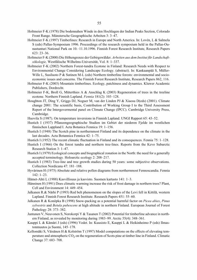
55
Holtmeier F-K (1978) Die bodennahen Winde in den Hochlagen der Indian Peaks Section, ColoradoFront Range. Münstersche Geographische Arbeiten 3: 3–47.
Holtmeier F-K (1997) Timberlines: Research in Europe and North America. In: Lovén, L & SalmelaS (eds) Pallas-Symposium 1996. Proceedings of the research symposium held in the Pallas-Ou-nastunturi National Park on 10.–11.10.1996. Finnish Forest Research Institute, Research Papers623: 23–36.
Holtmeier F-K (2000) Die Höhengrenze der Gebirgswälder. Arbeiten aus dem Institut für Landschaft-sökologie, Westfälische Wilhelms-Universität, Vol. 8: 1–337.
Holtmeier F-K (2002) Northern Forest-tundra Ecotone in Finland: Research Needs with Respect toEnvironmental Change Considering Landscape Ecology. (abstract). In: Kankaanpää S, Müller-Wille L, Susiluoto P & Sutinen M-L (eds) Northern timberline forests: environmental and socio-economic issues and concerns. The Finnish Forest Research Institute, Research Papers 862, 116.
Holtmeier F-K (2003) Mountain timberlines. Ecology, patchiness and dynamics. Kluwer AcademicPublishers, Dordrecht.
Holtmeier F-K, Broll G, Müterthies A & Anschlag K (2003) Regeneration of trees in the treelineecotone. Northern Finnish Lapland. Fennia 181(2): 103–128.
Houghton JT, Ding Y, Griggs DJ, Noguer M, van der Linden PJ & Xiaosu D(eds) (2001). Climatechange 2001: The scientific basis, Contribution of Working Group I to the Third AssessmentReport of the Intergovermental panel on Climate Change (IPCC). Cambridge University Press,Cambridge.
Huovila S (1987). On temperature inversions in Finnish Lapland. UNGI Rapport 65: 43–52.Hustich I (1937) Pflanzengeographische Studien im Gebiet der niederen Fjelde im westlichen
finnischen Lappland I. Acta Botanica Fennica 19: 1–156.Hustich I (1948) The Scotch pine in northernmost Finland and its dependence on the climate in the
last decades. Acta Botannica Fennica 42: 1–75.Hustich I (1952) The recent climatic fluctuation in Finland and its consequences. Fennia 75: 1–128.Hustich I (1966) On the forest tundra and northern tree-lines. Reports from the Kevo Subarctic
Research Station 3: 1–47.Hustich I (1979) Ecological concepts and biographical zonation in the North: the need for a generally
accepted terminology. Holoarctic ecology 2: 208–217.Hustich I (1983) Tree-line and tree growth studies during 50 years: some subjective observations.
Collection Nordicana 47: 181–188.Hyvärinen H (1975) Absolute and relative pollen diagrams from northernmost Fennoscandia. Fennia
142: 1–23.Hämet-Ahti L (1988) Kasvillisuus ja kasvisto. Suomen kartasto 141: 1–3.Hänninen H (1991) Does climatic warming increase the risk of frost damage in northern trees? Plant,
Cell and Environment 14: 449–454.Jalkanen R.& Närhi P (1993) Red belt phenomenon on the slopes of the Levi fell in Kittilä, western
Lapland. Finnish Forest Research Institute. Research Papers 451: 55–60.Jalkanen R & Konôpka B (1998) Snow-packing as a potential harmful factor on Picea abies, Pinus
sylvestris and Betula pubescens at high altitude in northern Finland. European Journal of ForestPathology 28: 373–382.
Juntunen V, Neuvonen S, Norokorpi Y & Tasanen T (2002) Potential for timberline advance in north-ern Finland, as revealed by monitoring during 1983–99. Arctic 55(4): 348–361.
Kauppi L & Kämäri J (eds) (1996) Vedet. In: Kuusisto E, Kauppi L & Heikinheimo P (eds) Ilmas-tonmuutos ja Suomi, 145–178.
Kellomäki S, Väisänen H & Kolström T (1997) Model computations on the effects of elevating tem-perature and atmospheric CO2 on the regeneration of Scots pine at timber line in Finland. ClimaticChange 37: 683–708.

56
Kihlman AO (1890) Pflanzenbiologische Studien aus Russisch Lappland. Ein Beitrag zur Kentnissder regionalen Gliederung an der polaren Waldgrenze. Acta Societatis pro Fauna et Flora Fennica6(3): 1–263.
Kjällgren L & Kullman L (1998) Spatial pattern and structure of the mountain birch tree-limit in thesouthern Swedish Scandes: A regional percpective. Geografiska Annaler 80 A(1): 1–15.
Kjällgren L & Kullman L (2002) Geographical patterns of tree-limits of Norway spruce and Scotspine in southern Swedish Scandes. Norwegian Journal of Geography 56: 237–245.
KM1400 Series (1989) Mk II Data Loggers Operating Manual. Kane-May Limited, Hertfordshire.Köppen W (1919) Baumgrenze und Lufttemperatur. Petermanss Geographische Mitteilungen 65: 39–
42.Krjukov VV (1993) Ohranjaemye prirodnye territorii Kol’skogo Severa: realnoe polozenie i perspek-
tivy. In: Kalbin GV (ed) Rastitel’nye resursy Evropeiskogo Severa: produktivnast, racional’noeispolzoanie, ohrana. Kolskij Naucnyj Centr, Rosskoj Akademii Nauk, Apatity, 102.
Kronfuss H & Havranek WM (1999) Effects of elevation and wind on the growth of Pinus cembra L.in a subalpine afforestation. Phyton (Austria) Speciall Issue: “Eurosilva” 39(4): 99–106.
Kujansuu R (1967) On the deglaciation of western Finnish Lapland. Bulletin de la ComissionGéologique de Finlande 232: 1–98.
Kullman L (1979) Change and stability in the altitude of birch tree-limit in the southern SwedishScandes 1915–1975. Acta Phytogeographica Suecica 65: 1–121.
Kullman L (1981) Recent tree-limit dynamics of Scots pine (Pinus sylvestris L.) in the southernSwedish Scandes. Wahlenbergia 8: 1–67.
Kullman L (1990) Dynamics of altitudinal tree-limit in Sweden: a review. Norsk GeografiskTidsskrift 44: 103–116.
Kullman L (1992) Climatically induced regeneration patterns of marginal populations of Pinussylvestris in northern Sweden. Oecologia Montana 1: 5–10.
Kullman L (1997) Tree-limit stress and disturbance. A 25-year survey of geoecological change in theScandes Mountains of Sweden. Geografiska Annaler 75A: 139–165.
Kullman L (2000) Tree-limit rise and recent warming: A geoecological case study from the SwedishScandes. Norwegian Journal of Geography 54: 49–59.
Kullman L (2001) 20th-centry climate warming and tree-limit rise in the southern Scandes of Sweden.Ambio 30: 72–80.
Kultti S (2004) Holocene changes in treelines and climate from Ural mountains to Finnish Lapland.Yliopistopaino. Helsinki.
Kurula T & Heikkinen O (1996) Vertical temperature inversion on the fjell Ylläs, northern Finland.Prace Geograficzne 102: 453–458.
Larsen JA (1974) Ecology of the northern Continental forest border. In: Ives J & Barry R (eds) Arcticand Alpine Environments. Methuen, London, 341–369.
Larsen JA (1989) The northern forest border in Canada and Alaska – biotic communities and ecolog-ical relationships. Springer-Verlag, Berlin, Heidelberg, New York.
Lauer W & Klaus D (1975) Geological investigations on the timberline of Pico de Orizaba, Mexico.Arctic and Alpine Research 7(4): 315–330.
Leemans R (1995) Modelling global change impacts. (abstract) In: Korpilahti E, Salonen T & Oja S(eds) Caring for the forest: research in a changing world. IUFRO XX World Congress, 6–12August 1995, Tampere Finland, 127.
Lehtonen P (1992) Wind measurements at Ylläs broadcasting station 1982–1991. In: Tammelin B,Säntti K, Peltola E & Neuvonen H (eds) BOREAS, North wind – Pohjatuuli, an international ex-perts’ meeting on wind power in icing conditions, Hetta 10.–13.2.1992. Finnish MeteorologicalInstitute, Helsinki, 1–10.
Löve D (1970) Subarctic and subalpine: where and what? Arctic and Alpine Research 2: 63–73.

57
Luomajoki A (1993) Climatic adaptation of Norway spruce (Picea abies (L.) Karsten) in Finlandbased on male flowering phenology. Acta Forestalia Fennica 242: 1–28.
Manner R & Tervo T (1988) Lapin geologiaa, hiekkarannoista tuntureiksi, tulivuorista tasangoiksi,mannerjäätiköistä maaperäksi. Lapin maakuntaliitto ry. Lapin lääninhallitus, Rovaniemi.
Martin P (1996) Regional aspect of climate change. In: Peter D, Maracchi A & Ghazi A (eds) Climatechange impact on agriculture and forestry. European Comission, Brussels, 33–52.
Mayern H & Ott E (1991) Gebirgswaldbau Schutzwaldpflege. Gustav Fisher Verlag, Stuttgart – NewYork.
McCarroll D, Autio J, Heikkinen O & Koutaniemi L (1996) Degree of rock surface weathering onfjell summits in northern Finalnd: implications for thermal regime of last ice sheet. Boreas 25: 1–7.
McCarroll D, Jalkanen R, Hicks S, Tuovinen M, Gagen M, Pawellek, F, Eckstein D, Schmitt U, AutioJ & Heikkinen O (2003). Multiproxy dendroclimatology: a pilot study in northern Finland. TheHolocene 13 (6):829–838.
McKenzie D, Peterson DW, Peterson DL & Thorton PE (2003) Journal of Biogeography 30: 1093–1108.
Mielikäinen P (1979) Geological map of Finland, Quaternary deposits 1:100 000, sheet 3642 Pyhä-tunturi. Geological survey of Finland.
Mikola P (1952) The effect of recent climatic variations on forest-growth in Finland. Fennia 75: 69–75.
Mitchell VL (1973) A theoretical tree line in central Canada. Annals of the Association of AmericanGeographers 63: 296–301.
Mook R & Vorren K-D (1996) The temperature climate at the altitudinal vegetation limits in Skibotn,northern Norway. Paläoklimaforschung 20: 61–74.
Mustonen T (1997) Tykkyvauriot Kittilän Aakenustunturilla. Unpublished MSc thesis. Departmentof Geography, University of Oulu, Oulu.
Nikolov VV & Helmisaari H (1992) Silvics of the circumpolar boreal forest tree species. In: ShugartH, Leemans R & Bonan G (eds) A system analysis of the boreal forest.Cambridge UniversityPress, Cambridge, 13–84.
Norin BM (ed) (1978) Ary-Mas. Priodnye usloviya, flora i rastitel’nost’ samago severnogo v mirelesnogo massiva. Nauka, Leningrad.
Norokorpi Y (1994) Havumetsänrajan määräytyminen Suomessa. Metsäntutkimuslaitoksen tiedo-nantoja 539: 7–15.
Norokorpi Y & Kärkkäinen S (1985) Maaston korkeuden vaikutus puusto- ja kasvupaikkatunnuksiinsekä tykkytuhoihin Kuusamossa. Folia Forestalia 632: 1–26.
Norton DA & Schönenberger W (1984) The growth forms and ecology of Nothofagus solandri at thealpine timberline, Craigieburn Range, New Zealand. Arctic and Alpine Research 16(3): 361–370.
Odland A (1996) Differences in the vertical distribution pattern of Betula pubescens in Norway andits ecological significance. Paläoklimaforschung 20: 42–59.
Ojansuu R & Henttonen H (1983) Kuukauden keskilämpötilan, lämpösumman ja sademäärän paikal-listen arvojen johtaminen Ilmatieteen laitoksen mittaustiedoista. (Estimation of local values ofmonthly mean temperature, effective temperature sum and precipitation sum from the measure-ments made by the Finnish Meteorological Office). Silva Fennica 17: 143–160.
Owners’s manual & reference (1998) GARMIN Corporation. Hsin Tien, Taiwan.Payette S (1983) The forest tundra and present tree-lines of the Northern Quèbec-Labrador Peninsula.
Collection Nordicana 47: 3–23.Payette S & Fillion L (1984) White spruce expansion at the tree line and recent climatic cahnge. Ca-
nadian Journal of Forest Research 15: 241–251.Perttu K (1972) Skogsgänsens beroende av olika klimatologiska och topografiska faktorer. Skoghög-
skulan, Institutionen för skogsföryngring, Raporter och Uppsatser 34: 1–91.

58
Piirola J (1969) Rakkakenttien suhde metsänrajoihin Saariselällä. (Summary: Realtionship betweenBlock Fields and Forest Limits in Saariselkä, Finnish Lapland). Terra 81(3): 206–208.
Påhlsson L (ed) (1995). Vegetationtyper I Norden. Nordiska Ministerrådet, København. Tema Nord1994.
Rastas P (1984) Geological map of Finland, Quaternary deposits 1:100 000, sheet 2732 Kittilä. Geo-logical survey of Finland.
Ritchie JG (1960) The vegetation of the Northern Manitoba. Establishing the major zonation. Arctic13: 210–229.
Robertson A (1993) Effects of wind on boreal forests. In: Alden J, Mastrantonio JL & Ødum S (eds)Forest Development in Cold Climates. Plenum Press, New York, 203–225.
Sakai A & Eiga S (1983) Physiological and ecological aspects of cold adaption of boreal conifers. InKaurin Å, Junttila O & Nilsen J (eds) Plant production in the north. Proceedings from “Plant adap-tion workshop” Tromsö, Norway. September 4–9, 1983. Norwegian University Press, Tromsö-Oslo-Bergen-Stavanger, 157–170.
Sarvas R (1962) Investigations on the flowering and seed crop of Pinus sylvestris. CommunicationesInstituti Forestalis Fenniae 53: 1–198.
Sarvas R (1970) Investigations on the flowering and seed crop of Picea abies. Communicationes In-stituti Forestalis Fenniae 67: 1–84.
Seppä H (1996) Post-glacial dynamics of vegetation and tree-lines in the far north of Fennoscandia.Fennia 174: 1–96.
Sirén G (1994) Piirteitä Ylä-Lapin puu- ja metsänrajan siirtymisestä 1900-luvulla. Metsäntutkimus-laitoksen tiedonantoja 539: 23–34.
Slettjord S (1993) Development of an environmental forest and arboretum on the outer cost ofFinnmark county, Norway. In: Alden J, Mastrantonio JL & Ødum S (eds) Forest Development inCold Climates. Plenum Press, New York, 437–461.
Skre O (1972) High temperature demands for growth and development in Norway Spruce (Piceaabies /L.) Karst.) in Scandinavia. Meldinger fra Norges Landbrukshögskole 51(7): 1–29.
Solantie R (1974) Pohjois-Suomen lumipeitteestä. (On Snow Cover in Northern Finland). Acta Lap-ponica Fenniae 8: 74–89.
Sonninen M (1993) Puiden kasvumuodot ja kasvun vaihtelut korkeusvyöhykkeittäin PyhätunturinLaakakerolla. Unpublished MSc thesis. Department of Geography, University of Oulu, Oulu.
SPSS Base 8.0 (1998) Applications guide. SPSS Inc, Chicago.Stöcklin J & Körner C (1999) Recruitment and mortality of Pinus sylvestris near the Nordic tree line:
The role of climatic change and herbivory. Ecological Bulletins 47: 168–177.Supan A (1884) Grundzüge der physischen Erdkunde. Veit et Comp, Lepzig.Sutinen M-L, Ritari A, Holappa T & Kujala K (1997) Seasonal Changes in Soil Temperature and in
the Frost Hardiness of Scots Pine Roots Under Subarctic Conditions. Proceedings of the interna-tional symposium on physics, chemistry and ecology of seasonally frozen soils. Fairbanks,Alaska, June 10–12.1997. Special report. U.S. Army, cold regions research and engineeringlaboratory, 513–517.
Tammelin B (1988) Orografian aiheuttamista pienilmastollisista eroista Saariselän alueella. (Oro-graphically-caused microclimate variation in the Saariselkä region). Meteorological publications7: 1–67.
Tammelin B & Säntti K (1992). Huurrekertymät tunturien lakialueilla. (Rime accretation at the topareas of fells). Meteorological publications 19: 1–39.
Tasanen T & Veijola P (1994) Metsänraja tutkimuksen kohteena – kirjallisuuskatsaus. Metsäntut-kimuslaitoksen tiedonantoja 539: 80–145.
Terminen kasvukausi ja sen ilmastoseuranta (2005). Ilmatieteen laitos. Cited March 7th 2005 from:http://www.fmi.fi/saa/tilastot_72.html/

59
Tranquillini W (1979) Physiological ecology of the alpine timberline. Ecological studies 31.Springer-Verlag, Berlin, Heidelberg and New York.
Tuhkanen S (1980) Climatic parameters and indices in plant geography. Acta PhytogeographicaSuecica 67: 1–110.
Tuhkanen S (1984) A circumpolar system of climatic-phytogeographical regions. Acta BotanicaFennica 127: 1–50 p. + app.1–2.
Tuhkanen S (1993). Treeline in relation to climate, with special reference to oceanic areas. In: AldenJ, Mastrantonio JL & Ødum S (eds) Forest Development in Cold Climates. Plenum Press, NewYork, 115–134.
Tuhkanen S (1999) The northern timberline in relation to climate. In: Kankaanpää S, Tasanen T &Sutinen M-L (eds) Sustainable development in northern timberline forests. Proceedings of theTimberline workshop, May 10–11, 1998 in Whitehorse, Canada. Finnish Forest Research Insti-tute. Research Papers 734, 29–61.
Tuovinen M (1997) Ilmaston vaikutus männyn (Pinus sylvestris L.) paksuuskasvuun Yllästunturin al-titudinaalisella metsänrajavyöhykkeellä. Unpublished Phil.Lic. Thesis. Department of Geo-graphy. University of Oulu, Oulu.
Ukkola R (1995). Trampling tolerance of plants and ground cover in Finnish Lapland, with examplefrom the Pyhätunturi national park. Prace Geograficzne 98: 91–110.
Veijola P (1998) The northern timberlines and timberline forests in Fennoscandia. The Finnish ForestResearch Institute. Research Papers 672: 1–242.
Vorren K-D, Jensen C, Kirchhefer A, Alm T, Mørkved B, Karlsen SR & Kunzendorf H (1999).Regional Report 1. Northern Sub-oceanic. (Unpublished Report). In: Hicks S, Jalkanen R,McCarroll D, Gagen M & Pettigrew E (eds) FOREST, Final Reprort, 12–34.
Walter H (1964) Die Vegetation der Erde in öko-physiologisher Betrachtung. Bd. I, Die tropischenund subtropischen Zonen. Veb Gustav Fischer Verlag, Jena.
Wardle P (1974) Alpine timberlines. In: Ives JD & Barry RG (eds) Arctic and Alpine Environment.Methuen and Co Ltd, London, 371–402.
Wardle P (1993) Causes of alpine timberline: a review of the hypothesis. In: Alden J, MastrantonioJL & Ødum S (eds) Forest Development in Cold Climates. Plenum Press, New York, 89–103.
Whiteman CD (2000) Mountain meteorology. Fundamentals and applications. Oxford UniversityPress, Hong Kong.
Whittaker R H (1956) Vegetation of the Great Smoky Mountains. Ecological Monographs 26: 1–80.Woodward F (1988) Temperature and the distribution of plant species. In: Long S. & Woodward F
(eds) Plants and temperature. Symposia of the society for experimental biology, Number XXXXII. Society of Experimental Biology, Cambridge, 59–75.
Yoshino M (1975) Climate in a small area. An introduction to local meteorology. University of TokyoPress, Tokyo.
Zschokke H (1805) Beobachtungen im Hochgebirge auf einer Alpenreise in Sommer 1803. Isis,Wochenschrift von deutschen und schweizerischen Gelehrten BdI/II, Zürich.

A C T A U N I V E R S I T A T I S O U L U E N S I S
Distributed byOULU UNIVERSITY LIBRARY
P.O. Box 7500, FI-90014University of Oulu, Finland
Book orders:OULU UNIVERSITY PRESSP.O. Box 8200, FI-90014University of Oulu, Finland
S E R I E S A S C I E N T I A E R E R U M N A T U R A L I U M
436. Mänttäri, Satu (2005) Dihydropyridine receptors in skeletal muscle withcomparative reference to muscle development and exercise in mouse and salmon
437. Ruotsalainen, Heli (2005) Lysyl hydroxylases. Characterization of mouse lysylhydroxylases and generation of genetically modified lysyl hydroxylase 3 mouselines
438. Aflatuni, Abbas (2005) The yield and essential oil content of mint (Mentha ssp.) inNorthern Ostrobothnia
439. Tero, Niina (2005) Genetic structure at different spatial scales in metapopulationsof Silene tatarica
440. Säkkinen, Hannele (2005) Variation in the blood chemical constituents ofreindeer. Significance of season, nutrition and other extrinsic and intrinsic factors
441. Riihimäki, Mona-Anitta (2005) Flowering time and natural selection in Arabidopsislyrata
442. Koskela, Harri (2005) Some aspects of polarisation transfer in NMR spectroscopy
443. Jäkäläniemi, Anne (2005) Adaptation, population viability and colonization-extinction dynamics of Silene tatarica in riparian habitats
444. Kiviahde, Maija (2005) Effects of authentic learning and e-learning in anintroductory chemistry laboratory course
445. Meissner, Kristian (2005) Consequences of predator-prey interactions in borealstreams. Scaling up from processes to large-scale patterns
446. Oksanen, Pirita O. (2005) Development of palsa mires on the northern Europeancontinent in relation to Holocene climatic and environmental changes
447. Harjumaa, Lasse (2005) Improving the software inspection process with patterns
448. Ylianttila, Mari (2005) Structure-function studies of the peroxisomalmultifunctional enzyme type 2 (MFE-2)
449. Moisio, Kari (2005) Numerical lithospheric modelling: rheology, stress anddeformation in the central Fennoscandian Shield
450. Pöykkö, Heikki (2005) Host range of lichenivorous moths with special referenceto nutritional quality and chemical defence in lichens
451. Kinnula, Marianne (2006) The formation and management of a softwareoutsourcing partnership. A case study
A452etukansi.kesken.fm Page 2 Friday, January 27, 2006 10:07 AM

U N I V E R S I TAT I S O U L U E N S I SACTAA
SCIENTIAE RERUMNATURALIUM
OULU 2006
A 452
Jyrki Autio
ENVIRONMENTALFACTORS CONTROLLINGTHE POSITION OFTHE ACTUAL TIMBERLINE AND TREELINE ON THE FELLS OF FINNISH LAPLAND
FACULTY OF SCIENCE, DEPARTMENT OF GEOGRAPHY,UNIVERSITY OF OULU
ABCDEFG
UNIVERS ITY OF OULU P.O. Box 7500 F I -90014 UNIVERS ITY OF OULU F INLAND
A C T A U N I V E R S I T A T I S O U L U E N S I S
S E R I E S E D I T O R S
SCIENTIAE RERUM NATURALIUM
HUMANIORA
TECHNICA
MEDICA
SCIENTIAE RERUM SOCIALIUM
SCRIPTA ACADEMICA
OECONOMICA
EDITOR IN CHIEF
EDITORIAL SECRETARY
Professor Mikko Siponen
Professor Harri Mantila
Professor Juha Kostamovaara
Professor Olli Vuolteenaho
Senior assistant Timo Latomaa
Communications Officer Elna Stjerna
Senior Lecturer Seppo Eriksson
Professor Olli Vuolteenaho
Publication Editor Kirsti Nurkkala
ISBN 951-42-8006-7 (Paperback)ISBN 951-42-8007-5 (PDF)ISSN 0355-3191 (Print)ISSN 1796-220X (Online)
A 452
AC
TA Jyrki A
utioA452etukansi.kesken.fm Page 1 Friday, January 27, 2006 10:07 AM