university of hannover inst. of physical geography and landscape ecology volume modelling of soils...
TRANSCRIPT

University of HannoverInst. of Physical Geography and Landscape Ecology
Volume modelling of soils using GRASS
GIS 3D Tools
presented at
Second Italian GRASS Users Meeting,University of Trento, Feb. 1-2 2001
Markus NetelerUniversity of Hannover
Dr. Jaro Hofierka GeoModel, Bratislava

University of HannoverInst. of Physical Geography and Landscape Ecology
Outline of Presentation
GRASS 3D volume modeling tools
Examples on soil science applications(ongoing research)
Discussion

University of HannoverInst. of Physical Geography and Landscape Ecology
GRASS 3D volume modeling tools
GRASS 3D Raster Data Model (G3D)
Data representation: raster voxels
x, y, z, w(Rase 1998)

University of HannoverInst. of Physical Geography and Landscape Ecology
GRASS 3D volume modeling tools
3D Import
3D-ASCII sites (s.in.dbf): name|profile3d
desc|RECHTS HOCH MTIEF 1:OTIEF 2:UTIEF 3:STONR 4:IL_BOD2_ID 5:SNAS 6:FEUCH 7:ST3570018.000000|5766419.000000|-17.500000|%0.0 %35.0 %1.0 %22.0 %2.0 %5.0 %1.0 %3570018.000000|5766419.000000|-40.500000|%36.0 %45.0 %1.0 %22.0 %2.0 %5.0 %1.03570018.000000|5766419.000000|-78.000000|%46.0 %110.0 %1.0 %22.0 %2.0 %5.0 %1.03570018.000000|5766419.000000|-115.500000|%111.0 %120.0 %1.0 %22.0 %2.0 %5.0 %13570378.000000|5766152.000000|-15.000000|%0.0 %30.0 %10.0 %48.0 %0.0 %5.0 %9.03570378.000000|5766152.000000|-35.500000|%31.0 %40.0 %10.0 %14.0 %0.0 %5.0 %9.03570773.000000|5766415.000000|-35.500000|%31.0 %40.0 %10.0 %26.0 %0.0 %5.0 %9.03570773.000000|5766415.000000|-35.500000|%31.0 %40.0 %10.0 %43.0 %0.0 %5.0 %9.0
s.vol.idw Interpolation
s.vol.rst
s.to.rast3 Conversion

University of HannoverInst. of Physical Geography and Landscape Ecology
GRASS 3D volume modeling tools
3D data interpolation
s.vol.idw
Inverse Distance Weighted interpolation
s.vol.rst
Regularized Splines with Tension (Mitasova et. al)
tension parameter gradient calculation

University of HannoverInst. of Physical Geography and Landscape Ecology
GRASS 3D volume modeling tools
3D data tools for manipulation and exploration
s.vol.rst (Mitasova et al.) 3D interpolation from sites
Gradient calculation
Horizontal and vertical aspects

University of HannoverInst. of Physical Geography and Landscape Ecology
GRASS 3D volume modeling tools
3D data tools for manipulation and exploration
r3.mapcalc (Paudits & Hofierka) Grid volume data calculator
Operators comparing to 2D r.mapcalc
3D neighbourhood modifier: map[r,c,d]
r3.mapcalc test="if((ph_rst > 6.8) && (ph_rst < 7.1), ph_rst, null())"
pH value pH value

University of HannoverInst. of Physical Geography and Landscape Ecology
GRASS 3D volume modeling tools
3D data export and visualization
Export to 3D sites: r3.to.sites/NVIZ

University of HannoverInst. of Physical Geography and Landscape Ecology
GRASS 3D volume modeling tools
3D data visualization
r3.mkdspf/
r3.showdspf - openGL viewer
University of HannoverInst. of Physical Geography and Landscape Ecology
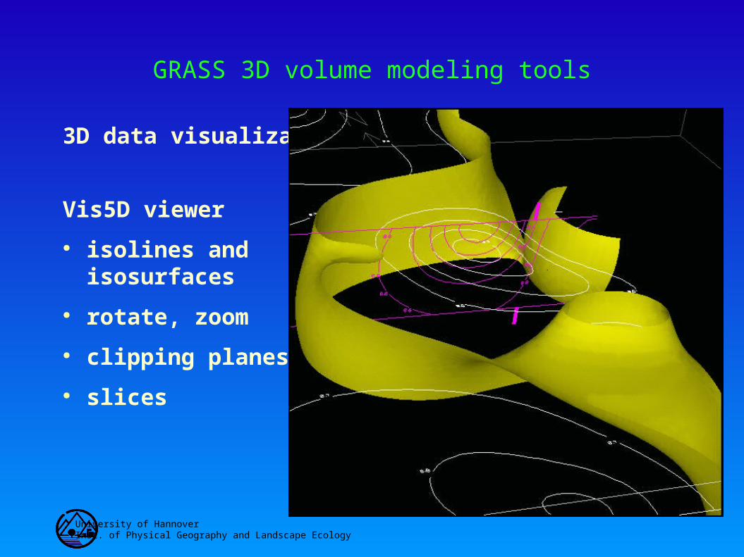
GRASS 3D volume modeling tools
3D data visualization
Vis5D viewer
isolines andisosurfaces
rotate, zoom
clipping planes
slices

University of HannoverInst. of Physical Geography and Landscape Ecology
GRASS 3D volume modeling tools
3D data visualization
r3.to.v5d
Vis5D viewer
volume visualization
3D data query withcursor

University of HannoverInst. of Physical Geography and Landscape Ecology
GRASS 3D volume modeling tools
3D Examples
Study area: 3x3 km2 south of Hannover, 2m soil depth max.

University of HannoverInst. of Physical Geography and Landscape Ecology
GRASS 3D volume modeling tools
3D Soil Data RECHTS East
HOCH NorthMTIEF avr. depth for horizontILDE_ID IDSTONR int. profile numberNR profile numberOTIEF upper horizont boundaryUTIEF lower horizont boundaryGWS influence of g.water (class)SNAS damming wetness (class)FEUCH soil moisture (class)LGDI soil compactnessSTEINE stones contentsORGSUB organic matter contentsKALK limestone contents (class)GWTIEFE depth to groundwater tableFSAND fine sand fractionMSAND medium sand fractionGSAND coarse sand fractionFSCHLUFF fine silt fractionMSCHLUFF medium silt fraction
GSCHLUFF coarse silt fractionTON clay fractionPHWERT pH-valueKFWERT permability coefficientNGESAMT nitrate contentsKAKPOT pot. cation exchange capacitySWERT sum of basic interacting cationsVWERT base saturationPHOS phosphor contentsBOTYP soil type (German taxonomy)KULTUR landuseMGW avr. depth to groundwater tableGRUN rootable depthHORIZ letter suffixes of master horizonsFARBE soil colorHNBOD soil textureWURZELN rooting activitySKELETT skeletal elements contentsLDSV effective compactness

University of HannoverInst. of Physical Geography and Landscape Ecology
GRASS 3D volume modeling tools
Demonstration of
Vis5D

University of HannoverInst. of Physical Geography and Landscape Ecology
GRASS 3D volume modeling tools
Conclusion
Technical view
Technology which performs on common PC
However limitations due to data intensity
Still inconsistencies to fix in 2D/3D GRASS

University of HannoverInst. of Physical Geography and Landscape Ecology
GRASS 3D volume modeling tools
Conclusion
Scientific view
Problem of 3D data availability
Note: Interpolations don't represent natural phenomena
Problem of 3D modelling within boundaries (soil units)
Time representation incomplete