united states land use in maine: determinants … use in maine: determinants of past trends and...
TRANSCRIPT

Land Use in Maine:Determinants of Past Trendsand Projections of FutureChangesAndrew J. Plantinga, Thomas Mauldin, and Ralph J. Alig
United StatesDepartment ofAgriculture
Forest Service
Pacific NorthwestResearch Station
Research PaperPNW-RP-511June 1999

ANDREW J. PLANTINGA is an assistant professor and THOMAS MAULDIN isresearch assistant, Department of Resource Economics and Policy, University ofMaine, Orono, ME 04469-5782; and RALPH J. ALIG is a research forester, U.S.Department of Agriculture, Forest Service, Pacific Northwest Research Station, 3200 SW Jefferson Way, Corvallis, OR 97331.
Authors

Plantinga, Andrew J.; Mauldin, Thomas; Alig, Ralph J. 1999. Land use in Maine:determinants of past trends and projections of future changes. Res. Pap. PNW-RP-511. Portland, OR: U.S. Department of Agriculture, Forest Service, PacificNorthwest Research Station. 20 p.
About 90 percent of the land in Maine is in forests. We analyzed past land usetrends in Maine and developed projections of future land use. Since the 1950s, thearea of forest in Maine has increased by almost 400,000 acres; however, the trendsdiffer among ownerships, as the area of nonindustrial private timberland declined by800,000 acres since 1950, while private industrial area rose by 681,000 acres. Weused econometric analyses to identify variables affecting land allocation, such aspopulation density. Estimated equations were used to generate decadal land useprojections to 2050. Our projections showed that private timberland area will declineby almost 3 percent by 2050, with urban areas increasing by 56 percent.
Keywords: Land use change, urban development, land rents, timberland area projections.
We examined past area trends for the major land uses in Maine as a basis fordeveloping projection models of future areas by forest ownership. This study pro-vides land use projections as input to the U.S. Department of Agriculture, ForestService's periodic efforts to assess future trends in the Nation's forest resources, inaccordance with the 1974 Resources Planning Act. Since the 1950s, the area of for-est land in Maine has increased by almost 400,000 acres, while the area of cropand pasture land has declined by about 900,000 acres. The increase in forest areais partially due to the natural reversion of agricultural land to trees. In contrast tomost states, the area of urban land in Maine has remained fairly stable over thepast several decades, at about 2.5 percent of total land area.
Private owners control 96 percent of the timberland in Maine, with slightly less thanhalf in private industrial ownership. The area of private industrial timberland hasdeclined by almost 960,000 acres since the 1970s, while nonindustrial private areaincreased by 680,000 acres.
Our area projections indicated that private timberland area will decline by almost 3 percent by 2050. This change would reduce the land available for timber produc-tion and other forest-based ecosystem goods and services. We also projected con-tinuing declines in agricultural areas.
Maine's population is projected to increase by 16 percent, which would result inurban land increases of 56 percent by 2050. The largest urban area increases arepredicted for counties in southern and central Maine.
Our results supported theoretical and empirical findings that land use patterns aredetermined by relative rents and land quality. Land tends to be allocated to the useproviding the highest land rents, and the rents associated with a given use mayaffect tradeoffs among other uses.
Abstract
Summary
1 Introduction
1 Land Use in Maine: Historical Trends and Determinants
4 An Econometric Model of Land Use in Maine
9 Projections of Land Use in Maine
16 Conclusions
17 Acknowledgments
18 Literature Cited
Contents

Since the 1950s, the area of forest land in Maine has increased by almost 400,000acres, while the area of crop and pasture land has declined by about 900,000 acres(table 1). The increase in forest area is, in part, the result of the reversion of agricul-tural lands to trees, a trend prevalent throughout New England since the turn of the20th century. In contrast to urban land expansion in most states in the Nation, thearea of urban land in Maine has remained stable over the past several decades atabout 2.5 percent of total land area.
The purpose of this report was to analyze past land use trends in Maine and, basedon these results, develop projections of future land use. The immediate purpose of this work was to provide input to the U.S. Department of Agriculture, ForestService's nationwide effort to assess future trends in the Nation’s forest resources inaccordance with the 1974 Resources Planning Act (RPA) (e.g., Haynes and others1995). Changes in land use, and particularly forest use, have important conse-quences for the future availability of timber, wildlife habitat, and other benefits pro-vided by forests. These results also support timber supply research being conductedby the Maine Forest Service, analyses of urban sprawl by the Maine State PlanningOffice (1997), and studies of development pressures on the forests in the NorthernUnited States (Northern Forest Lands Council 1994).
The next section of this paper discusses past trends in land use in Maine andreviews previous studies of the determinants of land use. Empirical evidence andland use theory are brought together under “An Econometric Model of Land Use.” In “Projections of Land Use in Maine,” projections are generated based on the estimation results of the econometric model section of this paper. Conclusions are contained in a final section.
According to the most recent data, about 90 percent of the land in Maine is forestland (table 1). The remaining 10 percent of the land area is divided among agricul-tural uses (3 percent), urban uses (2 percent), and other uses (5 percent). Defini-tions for these land use categories are provided in table 1. Forest and agriculturalland (crop and pasture land) are defined by the predominant vegetative cover.Urban land is defined by population concentrations, and other land is the differencebetween total land area and forest, agricultural, and urban land. Other land includesdeveloped land not classified as urban land (i.e., suburban housing, farmsteads,and rural transportation uses), wetlands, and miscellaneous uses.
Between 1950 and 1995, forest land area in Maine increased by 377,000 acres,principally as the result of a 329,000-acre increase in timberland. Within the timber-land category, private industrial land and non-Federal public land rose by 681,000and 487,000 acres, respectively. These increases were partially offset by a loss of802,000 acres of nonindustrial private timberland and a decline in Federal timber-land of 37,000 acres.
Although the dominant trend in timberland ownership over the last four decades hasbeen toward larger holdings by private industrial and non-Federal public land own-ers, during the last two decades, the opposite patterns have been observed. Privateindustrial timberland has declined by almost 960,000 acres since the 1970s. Sincethe 1980s, non-Federal public timberland has declined by about 45,000 acres, andprivate nonindustrial timberland has increased by over 650,000 acres.
Introduction
1
Land Use in Maine:Historical Trendsand Determinants

The dominant forest type groups in Maine are spruce-fir and northern hardwoods(Griffith and Alerich 1996, Powell and Dickson 1984). On average, over the pastseveral decades, 44 percent of Maine’s timberland was in the spruce-fir group compared to 32 percent for northern hardwoods. The remaining timberland was in white-red pine (11 percent), aspen-birch (9 percent), oak-hickory (2 percent), and elm-ash-red maple (2 percent). From 1971 to 1995, the area of timberland in spruce-fir declined considerably from 8,400,000 to 6,000,000 acres, mirroring an increase in northern hardwoods acreage from 4,900,000 to 6,400,000 acres. This trend is due to the reclassification of spruce-fir stands as northern hardwoodsfollowing harvests of spruce-fir species.
2
Table 1—Land use trends in Maine, 1950-95
Change1950s to
Land use 1950s 1960s 1970s 1980s 1990s 1990s
Thousand acres
Forest land:a 17,312 17,489 17,749 17,607 17,689 +377Timberland— 16,609 16,779 16,894 17,060 16,938 +329
Private industrial 6,617 6,521 8,255 8,016 7,298 +681 Private nonind. 9,810 10,053 8,328 8,353 9,008 -802Federal 90 66 73 65 53 -37Non-Federal public 92 139 238 625 579 +487
Other forest land 703 710 854 548 752 +49Crop landb 1,272 894 642 611 559 -713Pasture land 203 98 68 47 30 -174Urban landc 410 556 471 581 476 +66Other landd 556 716 824 907 999 +444
a Forest land is at least 1 acre in size, with trees stocked at a minimum of 10 percent or formerly hadsuch tree cover and is not currently developed. Timberland is forest land capable of producing crops of industrial wood greater than 20 cubic feet per acre per year and not withdrawn from timber utilization.Private industrial, private nonindustrial, Federal, and non-Federal public are different ownership typeswithin the timberland category. Other forest land is calculated as the difference between timberland andforest land. Sources: Ferguson and Kingsley 1972, Griffith and Alerich 1996, Powell and Dickson 1984,and Waddell and others 1989.
b Crop land is defined as land from which crops were harvested or hay was cut; land in orchards, citrusgroves, vineyards, nurseries, and greenhouses; crop land used for pasturing and grazing; land in covercrops, legumes, and soil-improvement grasses; land on which all crops failed; land cultivated in summerfallow; and idle crop land. Pasture land is land used for pasture or grazing other than crop land or woodland pastured (Census of Agriculture).
c The most recently used definition of urban land (Daugherty 1992) is (1) territory within an urbanizedarea or (2) a town with at least 2,500 people. An urbanized area comprises one or more places and theadjacent surrounding territory (urban fringe) that together have a minimum of 50,000 people. The urbanfringe generally has a density of at least 1,000 people per square mile.
d Other land is calculated as the difference between total land area and forest land, crop land, pastureland, and urban land. This category includes developed uses not classified as urban (e.g., suburbanhousing), wetlands, and miscellaneous uses.
to

Since the 1950s, agricultural land area has declined substantially, with crop landlosing 713,000 acres and pasture land losing 174,000 acres. Most of these lossesoccurred during the 1950s and 1960s. Given the large increases in forest area during this time, it is probable that much of this land reverted to forest. It also seemsthat a considerable share of these agricultural lands were converted to uses classi-fied as “other,” because other land area increased greatly. Notably, losses of agricul-tural acreage have diminished since the 1960s.
Urban land area has remained relatively stable at about 500,000 acres, reflectingMaine’s roughly constant population since the 1950s. The fluctuations in urban area reported in table 1 are the result of minor changes in the definition of urbanland over time. Although in some decades urban land area seems to decline, onlypositive changes should be observed because land development tends to be irre-versible. Lastly, other land area has almost doubled since the 1950s. In part, thismay be the result of development in rural areas (Maine State Planning Office 1997).
Previous theoretical and empirical studies of land use offer insights into the determi-nants of land use change in Maine. Modern land use theory builds on the early contributions of Ricardo and von Thunen. Ricardo introduced the concept of landrent, the supranormal profits derived by owners of highly productive land, and von Thunen explained how land use patterns arise when landowners allocateparcels to the use providing the highest rent. In his well-known model of a feature-less plain, agricultural commodities are produced in concentric zones surrounding a market center. Commodities that are more costly to transport and more perishabletend to be produced closer to the market.
Recent analyses extended the earlier work by Ricardo and von Thunen. Barlowe(1958) specified rents for given uses as decreasing functions of a fertility and loca-tion index termed “use-capacity.” Found (1971) modified the basic von Thunenmodel to allow for soil productivity differences and more complicated topographicalarrangements. In addition, the theories of Ricardo and von Thunen have been incorporated into structural models and tested empirically (e.g., Alig 1986, Caswelland Zilberman 1985, Howard and Lutz 1991, Lichtenberg 1989, Parks and Murray1994, Plantinga 1996, Plantinga and others 1989, Stavins and Jaffe 1990, Whiteand Fleming 1980, Wu and Brorsen 1995, Wu and Segerson 1995). The empiricalstudies support the central finding of the theoretical analyses that relative rents andland characteristics such as location and soil productivity determine land use.
Howard and Lutz (1991) estimated a land use model for the Northeastern UnitedStates (including Maine, New York, and Pennsylvania) and for each state individual-ly. Their model specified the shares of land in urban and other uses, pasture, crop,industrial timberland, farmer-owned timberland, and all other private timberland aslinear functions of urban population, rural population, per capita income, net farmincome, a stock market index, and pulping capacity. The data consist of time-seriesand cross-sectional observations at the survey unit level. In the equations for Maine,few of the parameter estimates are significantly different from zero, and some haveunexpected signs. Net farm income is positively related to shares of land in pastureand crop, but rural and urban population levels have negative and positive effects,respectively, on agricultural shares. In the forest land equations, only the coefficienton the urban population variable is significantly different from zero.
3

4
The results of previous studies dictate the specification of the econometric model inthe following section. In particular, landowners were assumed to allocate parcels tothe use providing the highest rent. Furthermore, land use patterns were influencedby soil quality. In general, we expected higher quality land to be allocated to agricul-tural uses and lower quality land to be in forests. No systematic relation was antici-pated between urban land and soil quality. Finally, many agricultural commoditiesand wood products produced in Maine are transported by truck down Interstate 95,through New Hampshire, and to markets beyond. Accordingly, we expected the travel time to the New Hampshire border to be an important determinant of land use patterns.
Our approach departed in several important ways from earlier work on Maine by Howard and Lutz (1991). First, we developed explicit rent measures for forest and agricultural uses by using available data on timber and agricultural commodityprices and yields. Our hope was that these variables would provide a sharper meas-ure of the monetary incentives for allocating land to these uses. Second, we includ-ed explicit measures of soil quality. Land quality measures were notably absent fromthe Howard and Lutz models. Plantinga (1995) demonstrated that the omission ofland quality variables can account for mixed results in previous empirical studies ofland use. Third, we used cross-sectional data on counties rather than survey units inan effort to use, to the greatest extent possible, homogeneous observational units.
In this section, we specify and test a statistical model of land use in Maine. Obser-vations of the shares of land in private timberland, agricultural land (crop and pas-ture land), and urban land in 16 counties and the years 1971, 1982, and 1995 wereconstructed from Forest Service inventories, Census of Agriculture reports, and thepopulation census. The shares of land in forest, agriculture, and urban uses aredenoted Fit, Ait, and Uit, respectively, where i indexes counties and t indexes time.According to table 1, these categories have accounted for roughly 90 percent of thetotal land area over the past several decades.
The remaining uses were not modeled explicitly, principally because suitable meas-ures of explanatory variables were unavailable. For example, it is difficult to identifymuch less measure the determinants of public forest land area. Among the landuses considered, less aggregated measures were available in some cases. Forinstance, private timberland can be divided into industrial and nonindustrial cate-gories. Corresponding measures of explanatory variables, however, cannot be constructed, thereby necessitating the use of the aggregate categories.
Proxies for land rents associated with the three land uses are included as explana-tory variables. For private timberland, rents are represented by a weighted averageof bare land values equal to the present discounted value of an infinite series ofrotations starting from bare ground (FRENTit). Values were estimated for each ofthe major forest species (white pine, spruce-fir, red maple, hard maple, and aspen)
An EconometricModel of LandUse in Maine

and averaged by using weights reflecting the species composition in each county.1
For agricultural land, the rent proxy is a weighted average of revenues equal to theproduct of crop price and yield (ARENTit). Weights reflect the shares of crop land ineach county planted in the major crops (hay, potatoes, oats, and corn).2 Urban landrents are represented by population density equal to total population divided by land area (URENTit). We hypothesized that larger populations result, all else beingequal, in greater development pressures and higher rents from developed uses.
Land quality measures were constructed from National Resources Inventory data(USDA Natural Resource Conservation Service 1996) on soil characteristics.AVERLCCit is the average land capability class (LCC) rating. The LCC system rankssoils (I to VIII, where I is highest) according to 12 characteristics (slope, permeabili-ty, etc.), and the overall LCC rating equals the lowest score in any category. TheLCC rating is based on the assumption that the characteristic receiving the lowestrating is the limiting factor for agricultural production. LCCI&IIit equals the percent-age of all land in LCCs I and II. Typically, high-quality land is allocated to agriculturaluses, whereas lower quality land is put into forest.
The last variable was the travel time to Portsmouth, New Hampshire (TRAVTIMEit).Travel times were measured from the major city or town closest to the geographiccenter of the county by using the software package PCMILER.3 Travel times corre-spond to the fastest route over major roads.
1 Stumpage prices are from the Maine Forest Service. A 3-yearaverage lagged 4 years was used to account for expectations formation and stand establishment as in Plantinga (1996). The price average was used to account for the possibility thatlandowners need to see a sustained change in prices beforecommitting their land to forest. The lag was used because deci-sions to put land in forest are observable only after trees havebecome established. Species weights were from U.S. Depart-ment of Agriculture, Forest Service (Haynes and other 1995);inventories and yields are from Birdsey (1992).
2 Crop prices and yields are from New England AgriculturalStatistics Service, personal communication,1997. Farmers wereassumed to have myopic expectations, namely, future pricesequal last year’s price (Wu and Segerson 1995). Weights wereconstructed from census of agriculture data on crop landacreages.
3 The use of trade or firm names in this publication is for readerinformation and does not imply endorsement by the U.S.Department of Agriculture of any product or service.
5

Following Caswell and Zilberman (1985), Lichtenberg (1989), Parks and Murray(1994), Wu and Brorsen (1995), and Wu and Segerson (1995), the shares of land inforest, agriculture, and urban uses were specified as multinomial logistic functions ofthe explanatory variables, Xit, and unknown parameters, β
F, β
A, β
U:
Fit = (1)
Ait = (2)
Uit = (3)
where
Fit = share of land in forest use in county i and year t,Ait = share of land in agricultural use in county i and year t,Uit = share of land in urban use in county i and year t,Xit = independent variables indexed to county i and year t, andβ = vector of unknown parameters.
Estimable models linear in the βs result from the transformations:
ln [Ait / Fit ] = (β0A - β0F) + (β1A - β1F) X1i t + (β2A - β2F) X2i t + . . +eitAF
ln [Uit / Fit] = (β0U - β0F) + (β1U - β1F) X1i t + (β2U - β2F) X2i t + . . +eitUF
ln [Uit / Ait ] = (β0U - β0A) + (β1U - β1A) X1i t + (β2U - β2A) X2i t + . . +eitUA
where the eit are heteroskedastic and, by assumption, normally distributed errors.4
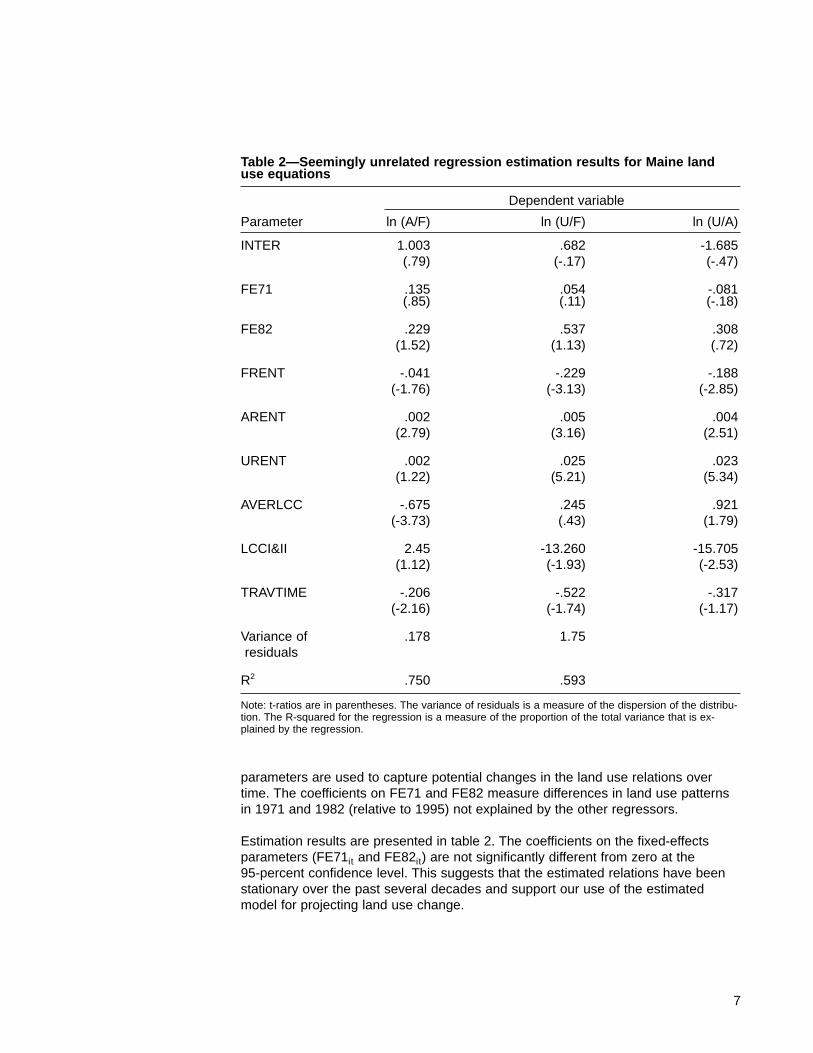
The error terms are likely to be correlated across equations because each of theshares appear in two equations. Accordingly, we estimated the first two equationsas a system by using Zellner’s Seemingly Unrelated Regression approach. The thirdequation is redundant because the vector of parameters equals the parameter vec-tor in the second equation minus the parameter vector in the first equation.5 Thetime-series and cross-sectional observations are pooled, and fixed effects para-meters for the 1971 and 1982 observations are included (FE71it and FE82it ). An intercept term (INTERit) also is included and so the fixed effects parameter for1995 is omitted to avoid perfect collinearity between regressors. The fixed effects
6
4 The structure of the heteroskedasticity is known in the case ofthe binomial logit model (Zellner and Lee 1965) but unknown inthe multinomial model.
5 The third equation is not included in the seemingly unrelatedregression analysis; however, parameter estimates and standarderrors for the third equation can be calculated from the estimatesfor the first two equations: (β0U - β0A) = (β0U - β0F) - (β0A - β0F)and Var(β0U - β0A) = Var(β0U - β0F) + Var(β0A - β0F) - 2Cov[(β0U- β0F)(β0A - β0F)].
eβF
1Xit
eβF
1 Xit + eβA
1 Xit + eβU
1 Xit
eβA
1Xit
eβF
1 Xit + eβA
1 Xit + eβU
1 Xit
eβU
1Xit
eβF
1 Xit + eβA
1 Xit + eβU
1 Xit
,
, and
7
parameters are used to capture potential changes in the land use relations overtime. The coefficients on FE71 and FE82 measure differences in land use patternsin 1971 and 1982 (relative to 1995) not explained by the other regressors.
Estimation results are presented in table 2. The coefficients on the fixed-effectsparameters (FE71it and FE82it) are not significantly different from zero at the 95-percent confidence level. This suggests that the estimated relations have beenstationary over the past several decades and support our use of the estimatedmodel for projecting land use change.
Table 2—Seemingly unrelated regression estimation results for Maine landuse equations
Dependent variable
Parameter ln (A/F) ln (U/F) ln (U/A)
INTER 1.003 .682 -1.685(.79) (-.17) (-.47)
FE71 .135 .054 -.081(.85) (.11) (-.18)
FE82 .229 .537 .308(1.52) (1.13) (.72)
FRENT -.041 -.229 -.188(-1.76) (-3.13) (-2.85)
ARENT .002 .005 .004(2.79) (3.16) (2.51)
URENT .002 .025 .023(1.22) (5.21) (5.34)
AVERLCC -.675 .245 .921(-3.73) (.43) (1.79)
LCCI&II 2.45 -13.260 -15.705(1.12) (-1.93) (-2.53)
TRAVTIME -.206 -.522 -.317(-2.16) (-1.74) (-1.17)
Variance of .178 1.75residuals
R2 .750 .593
Note: t-ratios are in parentheses. The variance of residuals is a measure of the dispersion of the distribu-tion. The R-squared for the regression is a measure of the proportion of the total variance that is ex-plained by the regression.

Most of the coefficients on the rent variables (FRENT, ARENT, URENT) were signifi-cantly different from zero (95-percent confidence level) and had the expected signs.Higher forest rents decreased the shares of agricultural and urban land relative tothe forest share, all else being equal. This implied that where forest rents were high-er, either agricultural and urban land shares tended to be lower or forest sharestended to be greater, or both. In the case of agricultural land, higher forest rentsmay have shifted the extensive margin between forestry and agriculture (i.e., thoseparcels providing the same returns to the two uses) in favor of forestry. With urbanland, higher returns to forestry may have forestalled conversion to developed uses.Finally, forest rents affected the tradeoff between agricultural and urban lands. Incounties with higher forest rents, the share of urban land relative to agricultural landtended to be lower.
Higher agricultural rents increased the share of agricultural land relative to the forestshare, with all else being equal. As above, higher agricultural rents may have shiftedthe extensive margin between agriculture and forestry in favor of agriculture.Unexpectedly, higher agricultural rents increased the share of urban land relative to the agriculture share, all else being equal. We expect the coefficient to either be negative or not significantly different from zero if urban rents greatly outweighedthose from agriculture. Lastly, counties with higher agricultural returns tended tohave more urban land relative to forest.
Counties with higher rents for urban uses tended to have higher shares of urbanland relative to shares of forest and agricultural land. In both cases, coefficient estimates were significantly different from zero. The coefficient on the urban rentvariable in the ln (A/F) equation was relatively small and not significantly differentfrom zero. This may indicate that the level of urban land rents has little effect on thetradeoff between agricultural and forest lands. Alternatively, higher urban rents mayhave affected agricultural and forest land shares in a manner that leaves the ratio of one to the other unchanged.
To a large degree, the coefficients on the land quality and travel time variables con-formed to expectations. Counties with lower quality land (i.e., higher average LCCratings) tended to have less agricultural land relative to forest. In contrast, thereseemed to be no systematic relation between land quality and shares of urban landrelative to forest and agricultural land. This is a plausible result because the rentsfrom urban uses were not affected by soil quality. Counties with higher percentagesof land in LCC I and II tend to have more agricultural land relative to forest andurban land, though the coefficient was not significantly different from zero in the ln (A/F) equation. Finally, the coefficients on the travel-time variable suggested thatmore remote counties (i.e., those farther from Portsmouth, New Hampshire) tendedto have less agricultural and urban land and more forest.
8

The estimated equations in table 2 were used to generate decadal land use projec-tions for Maine to 2050. Among the variables in the model, only the rent variablescould be expected to change in the future. Soil characteristics remained essentiallyconstant even over long periods, and the travel variable is assumed to be invariantwith respect to time. Changes in the rent variables implied changes in the land useshare ratios. From equation (2), the coefficient on a rent variable measured the per-centage change in the share ratio for a small increase in the rent. For instance, ifpopulation density increased by one person per square mile, A/F, U/F, and U/Awould increase by about 0.2, 2.5, and 2.3 percent, respectively.
The effects of changes in the rent variables on the individual shares A, F, and Uwere not identified by the relations in equation (2); however, the shares were identi-fied if the sum of the shares (i.e., A + F + U) is known. This value is equal to oneminus the share of land in public timberland, other forest land, and other land (table 1). Over the past three decades, these lands (hereafter, referred to as non-AFU lands) have increased by about 20,000 acres per year on average. For ourprojections, we assumed an annual increase of 10,000 acres and tested the sensi-tivity of our assumption by considering 0- and 20,000-acre increases (table 3).6
We isolated the effects of changes in rents by considering population, stumpageprice, and agricultural commodity price projection scenarios individually. State popu-lation projections were taken from U.S. Department of Commerce (1990), and coun-ty-level figures were derived by assuming that each county’s share of populationchange during the 1980s remains constant in the future. County-level changes inthe land use share ratios were calculated for the increases in population assumingthe medium projection for non-AFU land acreage (table 3) and holding forest andagricultural rents constant at 1995 levels. Individual land use shares were recoveredas described above.
The urban rent scenario implies that urban land acreage increases and forest andagricultural land acreages decline (table 4). Urban area is projected to increase byabout 265,000 acres by 2050, with much of the increase occurring in the first twodecades of the next century. Large losses of forest acreage are projected (declinesby 2050 are about 804,000 acres), yet agricultural acreage losses are relatively low at about 50,000 acres. The low losses of agricultural acreage are due in part to the positive effect of urban rents on the share of agricultural land relative to forest (table 2).
9
Projections of Land Use in Maine
6 Maine’s governor, Angus King, recently formed the LandAcquisition Priorities Advisory Committee for the purpose ofdeveloping strategies to increase conservation lands in the state. The group has recommended increasing the area of con-servation lands by 1,000,000 acres by 2020. Among the landtypes identified as conservation priorities are urban open space,undeveloped coastline, and large tracts of forest land in thenorthern part of the state. Some of these land uses (e.g., urbanopen space) are currently non-AFU lands, but others, includingforest lands in the northern part of the state, are now classifiedas private timberland. Thus, achieving the goal of a 1,000,000-acre increase will likely require some increase in the area ofnon-AFU lands. If, for instance, 500,000 acres of private timber-land are diverted to conservation uses by 2020, non-AFU landwill, on average, increase by 25,000 acres annually.

10
Stumpage price projections were from Haynes and others (1995). They project soft-wood and hardwood sawtimber and pulpwood stumpage prices for the NorthernUnited States, comprised of the north-central and northeast regions. We used thepercentage changes in these prices to project changes in stumpage prices forMaine forest types (table 3). The county-level weights for 1995 were assumed toapply throughout the projection period. Unlike the population scenario projections,we examined the effect of stumpage price changes only on the ratio of agricultural
Table 3—Price, population, and non-AFU landa trends used in projections
Year
Parameter 2000 2010 2020 2030 2040 2050
NumberSawtimber stumpageprices ($/mbf):
White pine 115 186 225 267 298 333Red maple 36 36 39 43 47 53Hard maple 77 77 83 92 102 114
Pulpwood stumpageprices ($/cf):
Spruce-fir 13 13 16 17 21 26Aspen 5 6 6 6 7 7
Crop returns($/acre):
Hay 116 151 181 200 220 242Potatoes 1,044 869 713 687 662 561Oats 59 71 78 82 86 91Corn 344 447 536 590 649 714
State population(x 1,000): 1,308 1,377 1,433 1,445 1,460 1,475
Non-AFU land(thousand acres):a
Low 2,421 2,421 2,421 2,421 2,421 2,421Medium 2,471 2,571 2,671 2,771 2,871 2,971High 2,521 2,721 2,921 3,121 3,321 3,521
Note: All dollar figures are in constant 1982 dollars. The Department of Commerce projects state popula-tion by decade to 2040. We assumed the same increase in population from 2040 to 2050 as projected for2030 to 2040.
a Non-AFU land = all land other than that in private timberland, agricultural land, and urban land; thisconsists of land in public timberland, other (nontimberland), forest land, and other miscellaneous land.
Sources: Haynes and others (1995) and U.S. Department of Commerce (1990).

land to forest. In the other equations, increases in forest rents imply large declinesin urban land acreage.7 Because it is plausible to assume that urban land areachanges can only be positive, we focused on the effects of stumpage prices on the tradeoff between forest and agricultural land.
Increases in real forest rents were projected for all counties in Maine. Assuming themedium scenario for non-AFU land and agricultural and urban rents were constantat 1995 levels, we projected declines of about 170,000 and 390,000 acres in forestland and agricultural land, respectively, by 2050 (table 5). Urban land is projected toremain roughly constant.8 Relative to the projections in table 4, forest declines aresubstantially lower. This result is due to increases in forest rents and the absence ofgains in urban land acreage, which account for forest area reductions in the first setof projections. The forest rent increases appear to draw a considerable amount ofland out of agriculture. Declines in agricultural acreage are considerably larger com-pared to the projections in table 4 that assume constant forest rents.
Table 4—Land use projections for Maine: urban rent scenario
Year
Land use 2000 2010 2020 2030 2040 2050
Thousand acres
Privatetimberland 16,215 16,035 15,862 15,743 15,623 15,502
Agriculturalland 563 557 551 547 543 538
Urban land 503 589 668 692 716 741
Non-AFU landa 2,471 2,571 2,671 2,771 2,871 2,971
Note: Forest and agricultural rents are assumed to remain constant at 1995 levels. Population increasesaccording to figures in table 3, and the medium values of non-AFU land are assumed.
a Non-AFU land = all land other than that in private timberland, agricultural land, and urban land; thisconsists of land in public timberland, other (nontimberland), forest land, and other miscellaneous land.
11
7 Because urban land shares are small relative to forestand agricultural land shares, there is considerable variationin the dependent variables ln(U/F) and ln(U/A). Conse-quently, the estimated coefficients on the forest rent vari-ables in these equations are relatively large (table 2). Thecoefficients may simply represent differences across coun-ties rather than measuring underlying causal effects.
8 As discussed above, we expect future changes in urbanland area to typically be positive and, thus, no significanceshould be attached to the small projected declines in urbanland area reported in tables 5 and 6. Projected decreasesare related to the assumption of constant urban rents andthe requirement that the land shares sum to 1.

Projections of agricultural returns were based on projections by the U.S. Departmentof Agriculture, Economic Research Service and Alig and others (1997) (table 3).Real per-acre returns are expected to increase for all commodities except potatoes.Accordingly, with the exception of Aroostook County where Maine potato productionis concentrated, increases in agricultural rents are predicted for all counties. Thishad the effect of reducing declines in agricultural acreage relative to the scenariosassuming constant agricultural rents. When forest and urban rents are held constantat 1995 levels, agricultural land area remains stable (table 6).
12
Table 5—Land use projections for Maine: forest rent scenarios
Year
Land use 2000 2010 2020 2030 2040 2050
Thousand acres
Privatetimberland 16,334 16,293 16,255 16,209 16,174 16,134
Agricultural land 488 432 372 320 258 200
Urban land 460 457 455 452 450 448
Non-AFU landa 2,471 2,571 2,671 2,771 2,871 2,971
Note: Stumpage prices are assumed to follow the projections in table 3. Agricultural and urban rentsare held constant at 1995 levels and the medium values of non-AFU land are assumed.
a Non-AFU land = all land other than that in private timberland, agricultural land, and urban land; thisconsists of land in public timberland, other (nontimberland), forest land, and other miscellaneous land.
Table 6—Land use projections for Maine: agricultural rent scenarios
Year
Land use 2000 2010 2020 2030 2040 2050
Thousand acresPrivatetimberland 16,283 16,198 16,108 16,004 15,899 15,802
Agriculturalland 539 526 519 525 533 532
Urban land 460 457 455 452 450 448
Non-AFU landa 2,471 2,571 2,671 2,771 2,871 2,971
Note: Agricultural returns are assumed to follow the projections in table 3. Forest and urban rents areheld constant at 1995 levels, and the medium values of non-AFU land are assumed.
a Non-AFU land = all land other than that in private timberland, agricultural land, and urban land; thisconsists of land in public timberland, other (nontimberland), forest land, and other miscellaneous land.

The effects of higher urban, forest, and agricultural rents were evaluated simultane-ously in a final set of projections (table 7). Urban, forest, and agricultural rents werechanged according to projections in table 3, and we considered the three scenariosfor non-AFU land. The medium scenario for non-AFU land might be regarded as themost likely. In this case, forest land declined by about 448,000 acres by 2050, andagricultural land declined by 407,000 acres from 1995 levels. Urban land increasedby about 265,000 acres. Assumptions about future changes in non-AFU land hadthe greatest effect on projections of forest acreage. There was almost a 1,000,000-acre difference in forest area between the low and high non-AFU scenarios. Pro-jections of agricultural and urban land area were much less sensitive to assump-tions about non-AFU land.
There was considerable variation in projected land use changes at the county level.We reported net changes in land use for the period 1995-2050 for Maine counties(table 8). The projections to 2050 assumed the medium scenario for non-AFU landand projected changes in forest, agricultural, and urban rents. The largest declinesin private timberland were projected for Cumberland, Piscataquis, and YorkCounties (fig. 1). In Cumberland and York Counties, large gains in urban areaincreases are expected. In these counties, timberland is primarily in white pine,
13
Table 7—Land use projections for Maine: non-AFU land scenariosa
Year
Land use 2000 2010 2020 2030 2040 2050
Thousand acresPrivate timberland:
Low 16,366 16,340 16,320 16,333 16,355 16,379Medium 16,318 16,198 16,083 16,003 15,929 15,858High 16,271 16,056 15,847 15,672 15,503 15,337
Agricultural land:Low 462 398 335 293 242 188Medium 460 395 330 287 236 182High 459 391 326 282 230 177
Urban land:Low 504 594 678 706 735 764Medium 503 589 668 692 716 741High 502 585 659 679 698 718
Non-AFU land:a
Low 2,421 2,421 2,421 2,421 2,421 2,421Medium 2,471 2,571 2,671 2,771 2,871 2,971High 2,521 2,721 2,921 3,121 3,321 3,521
Note: Forest, agricultural, and urban rents follow the projections in table 3.
a Non-AFU land = all land other than that in private timberland, agricultural land, and urban land; thisconsists of land in public timberland, other (nontimberland), forest land, and other miscellaneous land.

oak-hickory, and northern hardwood forest types and held primarily by nonindus-trial owners. Agricultural land area declines the most in Aroostook County as the result of projected decreases in potato prices. Non-AFU increases are largest in Piscataquis County, where a large share of private timberland is expected to be reclassified as non-Federal public timberland and other land. Timberland in Piscataquis County is evenly split between spruce-fir and northern hardwoods forest types.
Lastly, we presented projections for disaggregated land use categories derived from the scenario reported in table 7. In spite of some recent changes mentionedabove, industrial and nonindustrial shares of private timberland have remainedroughly constant since the 1950s at 45 and 55 percent, respectively. We assumedthese percentages apply throughout the projection period. The share of total agricul-tural land for crop land increased from about 85 percent in the 1950s to about 95percent currently. We assumed that the share of agricultural land for crop land willcontinue to be 95 percent in the future, with pasture land accounting for the remain-ing 5 percent. The share of Federal timberland non-AFU land is assumed to remain at 2 percent until 2050 and, likewise, the share of other land is assumed to hold at 42 percent. In view of current efforts by the Maine State government to increase
14
Table 8—Changes in land use projected for Maine counties, 1995-2050
Private Agricultural Urban Non-AFUa
County timberland land land land
Acres
Androscoggin -12,000 -20,000 27,000 6,000Aroostook 60,000 -153,000 -3,000 96,000Cumberland -101,000 -22,000 101,000 23,000Franklin -15,000 -7,000 0 22,000Hancock -31,000 -6,000 2,000 35,000Kennebec 6,000 -35,000 20,000 9,000Knox -10,000 -3 3,000 11,000Lincoln -6,000 -8,000 0 15,000Oxford -25,000 -19,000 0 43,000Penobscot -32,000 -29,000 7,000 54,000Piscataquis -100,000 -7,000 0 107,000Sagadahoc -10,000 -6,000 11,000 5,000Somerset -19,000 -19,000 1,000 38,000Waldo -13,000 -6,000 5,000 15,000Washington -44,000 -17,000 0 61,000York -94,000 -24,000 107,000 11,000
Total -447,000 -38,4000 280,000 550,000
Note: Acreages for 2050 assume projected values of forest, agricultural, and urban rents and the mediumscenario for non-AFU land.
a Non-AFU land = all land other than that in private timberland, agricultural land, and urban land; thisconsists of land in public timberland, other (nontimberland), forest land, and other miscellaneous land.

Figure 1—Maine counties.
15

land in conservation uses, the share of non-AFU land classified as non-Federal public timberland is assumed to increase to 30 percent by 2000 and increase by 1 percent each decade thereafter. Since the 1950s, the share of non-Federal publictimberland has increased from 6 percent to 24 percent. Finally, the acreage of otherforest land is assumed to remain roughly constant, implying annual 1 percentdeclines in the share of other forest land of non-AFU land.
The projections for disaggregated land uses are reported in table 9. Private indus-trial and nonindustrial timberland are projected to decline by about 160,000 and250,000 acres, respectively. Federal timberland and other forest land show littlechange, and non-Federal public timberland increases by almost 500,000 acres by2050, roughly doubling from 1995 levels. Crop and pasture land show significantdeclines, with the largest absolute losses in crop land area, and urban and otherland increase by about 265,000 and 250,000 acres, respectively.
The land use projections presented in this analysis support the Resources PlanningAct (e.g., Haynes and others 1995) analyses currently being conducted by the U.S. Department of Agriculture, Forest Service. Our results provided area projec-tions for private and public forest land and nonforest uses that will be incorporatedinto a national assessment of forest resources. An important component of thenational assessment is the analysis of future timber supplies. Our projections showthat in Maine, private timberland acreage will decline by almost 3 percent by themiddle of the 21st century. This change will reduce the land available for timber production, though the effect on timber supply is not likely to be dramatic given thatlarge acreages of timberland will still remain. The timberland area projections alsoprovide input to current timber supply analyses by the Maine Forest Service.
16
Table 9—Land use projections for Maine: disaggregated land use categories
Year
Land use 2000 2010 2020 2030 2040 2050
Thousand acres
Forest land: 16,961 16,841 16,725 16,640 16,561 16,482Timberland— 16,318 16,198 16,083 16,003 15,929 15,858
Private ind. 7,343 7,289 7,238 7,201 7,168 7,136 Private nonind. 8,975 8,909 8,846 8,801 8,761 8,722Federal 49 51 53 55 57 59Non-Federal public 741 797 855 914 976 1,040
Other forest land 642 643 641 637 632 624Crop land 437 375 314 273 225 173Pasture land 23 20 17 14 12 9Urban land 503 589 668 692 716 741Other land 1,038 1,080 1,122 1,164 1,206 1,248
Note: The medium scenarios for non-AFU land is used.
Conclusions

Since the 1950s, the area of urban land in Maine has remained stable, yet if popu-lation increases according to Department of Commerce projections, this pattern may change dramatically. The population projections show a 16-percent increase in Maine's population by 2050, which results in urban land area increases of 56 per-cent. As evidenced, there is an elastic relation between urban land area and popu-lation (the elasticity equals 3.5). The largest urban area increases are predicted forcounties in southern and central Maine. These changes may have potentially largefiscal impacts on local municipalities in addition to adverse effects on the characterof rural communities and environmental quality (Maine State Planning Office 1997).
For the remaining land uses, we expect historical trends to continue.9 Non-Federalpublic timberland is projected to increase by about 100 percent from 1995 levels by2050, continuing the large increases starting in the 1950s. We also project continu-ing declines in agricultural acreage, though in absolute terms, changes are expectedto be lower in the next 50 years compared to the previous 50 years. Finally, we pro-ject continuing increases in other land; however, average annual increases areexpected to be about 50 percent lower than historical increases.
Our results lend further support to the theoretical and empirical findings that landuse patterns are determined by relative rents and land quality. The coefficients onrent variables in the econometric model indicated that land tends to be allocated tothe use providing the highest rents and that the rents associated with a given usemay affect the tradeoff between other uses. Furthermore, we found that higher qual-ity land tends to be allocated to agricultural uses, that lower quality land tends to beforested, and that land quality does not significantly affect urban land use patterns.Lastly, our results support the von Thunen land use model in which distances tomarkets affect land use patterns.
Financial support for this research was provided by a Cooperative Agreementbetween the University of Maine and U.S. Department of Agriculture, Forest Service,Pacific Northwest Research Station. The authors thank Jacqueline Keoghegan, JeffKline, and Todd Schatzki for valuable comments and suggestions, and Carol Alerich,U.S. Department of Agriculture, Forest Service, Pacific Northwest Research Station,for providing data and review comments.
17
9 It should be reemphasized that our projections of non-Federal public timberland and other land are based on pasttrends, rather than being generated from the estimates ofour econometric model.
Acknowledgments

Alig, R.J. 1986. Econometric analysis of the factors influencing forest acreagetrends in the southeast. Forest Science. 32: 119-134.
Alig, R.J.; Adams, D.; McCarl, B. [and others]. 1997. Assessing effects of globalchange mitigation strategies with an intertemporal model of the U.S. forest andagricultural sectors. Environmental and Resource Economics. 9(3): 259-274.
Barlowe, R. 1958. Land resource economics; the political economy of rural andurban land resource use. Englewood Cliffs, NJ: Prentice-Hall. 585 p.
Birdsey, R.A. 1992. Changes in forest carbon storage from increasing forest areaand timber growth. In: Sampson, N.R.; Hair, D., eds. Forests and global change,volume one: opportunities for increasing forest cover. Washington, DC: AmericanForests: 23-40. Chapter 3.
Caswell, M.; Zilberman, D. 1985. The choices of irrigation technologies inCalifornia. American Journal of Agricultural Economics. 67: 224-234.
Caswell, M.; Zilberman, D. 1986. The effects of well depth and land quality on thechoice of irrigation technology. American Journal of Agricultural Economics. 68:798-811.
Daugherty, A.B. 1992. Major uses of the land in the United States, 1992.Agricultural Economic Report No. 723. Washington, DC: U.S. Department ofAgriculture, Economic Research Service. 39 p.
Ferguson, R.H.; Kingsley, N.P. 1972. The timber resources of Maine. Resour. Bull. NE-26. Upper Darby, PA: U.S. Department of Agriculture, Forest Service,Northeastern Forest Experiment Station. 129 p.
Found, W.C. 1971. A theoretical approach to rural land-use patterns. London:Edward Arnold. 190 p.
Griffith, D.M.; Alerich, Carol L. 1996. Forest statistics for Maine, 1995. Resour.Bull. NE-135. Radnor, PA: U.S. Department of Agriculture, Forest Service,Northeastern Forest Experiment Station. 134 p.
Haynes, R.W.; Adams, D.M.; Mills, J.R. 1995. The 1993 RPA timber assessmentupdate. Gen. Tech. Rep. RM-259. Fort Collins, CO: U.S. Department ofAgriculture, Forest Service, Rocky Mountain Forest and Range ExperimentStation. 66 p.
Howard, Theodore E.; Lutz, Jack. 1991. Land use and ownership change in the Northeast. Unnumbered report. New Hampshire, Durham: New HampshireAgricultural Experiment Station. 43 p.
Lichtenberg, E. 1989. Land quality, irrigation development, and cropping patterns in the Northern High Plains. American Journal of Agricultural Economics. 71: 187-194.
Literature Cited
18

Maine State Planning Office. 1997. The cost of sprawl. Maine: Maine StatePlanning Office. 41 p.
Northern Forest Lands Council. 1994. Finding common ground: conserving thenorthern forest. The Recommendations of the Northern Forest Lands Council,[Place of publication unknown]; September. 98 p.
Parks, P.; Murray, B. 1994. Land attributes and land allocation: nonindustrial forestuse in the Pacific Northwest. Forest Science. 40: 558-575.
Plantinga, A.J. 1995. The allocation of land to forestry and agriculture. Berkeley:University of California. 89 p. Ph.D. dissertation.
Plantinga, A.J. 1996. The effect of agricultural policies on land use and environ-mental quality. American Journal of Agricultural Economics. 78: 1082-1091.
Plantinga, Andrew; Buongiorno, Joseph; Alig, Ralph J.; Spencer, John S., Jr.1989. Timberland area change in the Lake States: past trends, causes, and pro-jections. Res. Pap. NC-287. St. Paul, MN: U.S. Department of Agriculture, ForestService, North Central Forest Experiment Station. 17 p.
Powell, D.S.; Dickson, David R. 1984. Forest statistics for Maine: 1971 and 1982.Resour. Bull. NE-81. Broomall, PA: U.S. Department of Agriculture, ForestService, Northeastern Forest Experiment Station. 194 p.
Stavins, R.; Jaffe, A. 1990. Unintended impacts of public investment on privatedecisions: the depletion of forest wetlands. American Economics Review. 80: 337-352.
U.S. Department of Agriculture, Natural Resources Conservation Service.1992. The 1992 National Resource Inventory in the United States. Unnumberedreport, Washington, DC. 33 p.
U.S. Department of Commerce, Bureau of Economic Analysis. 1990. Bureau ofEconomic Analysis regional projections to 2040: volume I. Washington, DC: U.S.Government Printing Office. 79 p.
Waddell, K.L.; Oswald, D.D.; Powell, D.S. 1989. Forest statistics of the UnitedStates, 1987. Resour. Bull. 168. Portland, OR: U.S. Department of Agriculture,Forest Service, Pacific Northwest Research Station. 106 p.
White, F.; Fleming, F. 1980. An analysis of competing agricultural land uses.Southern Journal of Agricultural Economics. 12: 99-103.
Wu, J.; Brorsen, B.W. 1995. The impact of government programs and land characteristics on cropping patterns. Canadian Journal of Agricultural Economics.43: 87-104.
19

Wu, J.; Segerson, K. 1995. The impact of policies and land characteristics onpotential groundwater pollution in Wisconsin. American Journal of AgriculturalEconomics. 77: 1033-1047.
Zellner, A.; Lee, T.H. 1965. Joint estimation of relationships involving discrete random variables. Econometrica. 33: 382-394.
20

This page has been left blank intentionally.Document continues on next page.

This page has been left blank intentionally.Document continues on next page.
Plantinga, Andrew J.; Mauldin, Thomas; Alig, Ralph J. 1999. Land use in Maine: deter-minants of past trends and projections of future changes. Res. Pap. PNW-RP-511.Portland, OR: U.S. Department of Agriculture, Forest Service, Pacific Northwest ResearchStation. 20 p.
About 90 percent of the land in Maine is in forests. We analyzed past land use trends inMaine and developed projections of future land use. Since the 1950s, the area of forest inMaine has increased by almost 400,000 acres; however, the trends differ among owner-ships, as the area of nonindustrial private timberland declined by 800,000 acres since1950, while private industrial area rose by 681,000 acres. We used econometric analysesto identify variables affecting land allocation, such as population density. Estimated equa-tions were used to generate decadal land use projections to 2050. Our projectionsshowed that private timberland area will decline by almost 3 percent by 2050, with urbanareas increasing by 56 percent.
Keywords: Land use change, urban development, land rents, timberland area projections.
The Forest Service of the U.S. Department of Agricul-ture is dedicated to the principle of multiple use man-agement of the Nation’s forest resources for sustainedyields of wood, water, forage, wildlife, and recreation.Through forestry research, cooperation with the Statesand private forest owners, and management of theNational Forests and National Grasslands, it strives—as directed by Congress—to provide increasinglygreater service to a growing Nation.
The U.S. Department of Agriculture (USDA) prohibitsdiscrimination in all its programs and activities on thebasis of race, color, national origin, gender, religion,age, disability, political beliefs, sexual orientation, ormarital or family status. (Not all prohibited bases applyto all programs.) Persons with disabilities who requirealternative means for communication of program infor-mation (Braille, large print, audiotape, etc.) should con-tact USDA's TARGET Center at (202) 720-2600 (voiceand TDD).
To file a complaint of discrimination, write USDA,Director, Office of Civil Rights, Room 326-W, WhittenBuilding, 14th and Independence Avenue, SW,Washington, DC 20250-9410 or call (202) 720-5964(voice and TDD). USDA is an equal opportunity providerand employer.
Pacific Northwest Research Station333 S.W. First AvenueP.O. Box 3890Portland, Oregon 97208-3890
U.S. Department of AgriculturePacific Northwest Research Station333 S.W. First AvenueP.O. BoxPortland, Oregon 97208-3890
Official BusinessPenalty for Private Use, $300
do NOT detach Label