united states department of the interior states department of the interior ... proposed action on...
TRANSCRIPT

United States Department of the Interior
FISH AND WILDLIFE SERVICE 10711 Burnet Road, Suite 200
Austin, Texas 78758 512 490-0057
FAX 490-0974
December 3, 2004
Wayne A. Lea Chief, Regulatory Branch Fort Worth District, Corps of Engineers P.O. Box 17300 Fort Worth, Texas 76102-0300 Consultation No. 2-15-F-2004-0242 Dear Mr. Lea: This document transmits the U.S. Fish and Wildlife Service's (Service) biological opinion based on our review of the proposed water operations by the Colorado River Municipal Water District (District) on the Colorado and Concho rivers, located in Coleman, Concho, Coke, Tom Green, and Runnels counties. These actions are authorized by the U.S. Army Corps of Engineers (Corps) under Permit Number 197900225, Ivie (Stacy) Reservoir project, pursuant to compliance with the Clean Water Act. The District and the Corps have indicated, through letters dated September 10, 2004, and September 13, 2004, respectively, that an emergency condition affecting human health and safety exists with this action. We have considered the effects of the proposed action on the federally listed threatened Concho water snake (Nerodia harteri paucimaculata) in accordance with formal interagency consultation pursuant to section 7 of the Endangered Species Act (Act) of 1973, as amended (16 U.S.C. 1531 et seq.). The emergency consultation provisions are contained within 50 CFR section 402.05 of the Interagency Regulations. Your July 8, 2004, request for reinitiating formal consultation was received on July 12, 2004. You designated District as your non-federal representative. This biological opinion is based on information provided in agency reports, telephone conversations, field investigations, and other sources of information. A complete administrative record of this consultation is on file at the Austin Ecological Services Field Office. Consultation History Conference Report On February 21, 1986, the Corps requested the Service prepare a section 7 Conference Report for the Concho water snake under Section 7(a)(4) of the Act. That report, dated May 5, 1986, concurred with the Corps' finding that Stacy Dam was likely to jeopardize the continued existence of the Concho water snake (then proposed for listing) and was likely to adversely modify proposed critical habitat. The Concho water snake was listed as a threatened species on September 3, 1986. Critical habitat, proposed for the snake on January 22, 1986, was deferred until the economic data on the impact of that proposal could be gathered and assessed.

Biological Opinion, USACE/CRMWD (2-15-F-2004-0242) December 3, 2004
2
Original biological opinion On December 19, 1986, the Service issued its biological opinion, finding the proposed action was likely to jeopardize the continued existence of the Concho water snake and adversely modify the proposed critical habitat (Service 1986). The Federal action under consultation was the proposal by the Corps to issue a Section 404 (Clean Water Act) and Section 10 (Rivers and Harbors Act) permit to the District for the construction and operation of the proposed Stacy Dam, O.H. Ivie Reservoir, and pump station on the Colorado River in Coleman, Concho, and Runnels counties, Texas. The biological opinion was the culmination of all the research that had been completed on the Concho water snake from 1979 through 1986. It provided detailed information on the snake, its known biology, distribution, and presented a comprehensive account of the potential threats plus viability of the species based upon a computer generated risk analysis model. The opinion provided ten (10) reasonable and prudent alternatives (RPAs) to be implemented by the District to avoid jeopardizing the snake. A commitment to carry out the RPAs was confirmed in a Memorandum of Agreement (MOA), signed March 1987, between the District, the Service, and the Corps. The Corps issued a Federal permit on April 8, 1987. Amendment No. 1 On March 7, 1989, the biological opinion was amended as a result of new information that had been collected. Some of the reasonable and prudent alternatives were modified to be consistent with the new available information. Amendment No. 2 The final rule designating critical habitat for Concho water snake was published June 29, 1989. On November 28, 1989, the biological opinion was amended to address critical habitat (adverse modification was determined) and removed some requirements to move snakes within reservoir basins. Amendment No. 3 On November 23, 1992, the biological opinion was amended (labeled Amendment #2) to include District plans to construct a water pipeline from the San Angelo pump station to the Midland/Odessa metropolitan area. The pipeline crossed the Concho River roughly 3 miles (4.8 kilometers) northeast of the community of Paint Rock. Amendment No. 4 On December 21, 2000, the Service issued another amendment to the biological opinion (Consultation Number 2-15-00-F-0636). This amendment included an additional action by District to construct a pump station at Ivie Reservoir, a water pipeline to Abilene and a water treatment plant in Taylor County. Present Consultation The Corps requested the Service reinitiate consultation on this project by letter dated July 8, 2004. The Service responded by letter to the Corps dated July 16, 2004, to reinitiate formal

Biological Opinion, USACE/CRMWD (2-15-F-2004-0242) December 3, 2004
3
consultation (Consultation Number 2-15-F-2004-0242). District indicated to the Service by letter dated September 10, 2004, that an emergency situation existed due to a limited water supply endangering public health and safety to their municipal customers (450,000 people). The Corps concurred with the emergency consultation by email to the Service, dated September 13, 2004. The Interagency Regulations define an emergency as "situations involving acts of God, disasters, casualties, national defense or security emergencies, etc." The 10-year drought and the implementation of the conditions in the Service's December 19, 1986, biological opinion, were the basis for this emergency. District documented, by letter dated September 16, 2004, their intent to decrease reservoir releases from Spence and Ivie reservoirs as a result of the ongoing low water situation. District indicated the low water situation would be alleviated when both reservoirs reach 50 percent capacity (at the time Spence Reservoir was at 7 percent capacity and Ivie Reservoir was at 30 percent capacity). The Service concurred with the District emergency procedures by letter dated September 21, 2004. This consultation will apply once the current emergency has ended, in other words when both Spence and Ivie reservoirs are at, or above, 50 percent capacity in water storage or once the District, in discussions with the Corps and the Service, has determined that other factors have ended the emergency condition. The District will notify the Corps and the Service when either of the above conditions trigger the end of the emergency condition. This Revised Biological Opinion replaces the Biological Opinion dated December 19, 1986. When the emergency condition ends, the requirements of this Revised Biological Opinion will go into effect. BIOLOGICAL OPINION I. Description of Proposed Action Historical Operation. The District was authorized in 1949 by an Act of the 51st Legislature of the State of Texas for the purpose of providing water to the District's Member Cities of Odessa, Big Spring, and Snyder (see Figure 1). The District also has contracts to provide specified quantities of water to the Cities of Midland, San Angelo, Stanton, Robert Lee, Grandfalls, Pyote, and Abilene (through the West Central Texas Municipal Water District). A twelve-member Board of Directors governs the District. Each Member City appoints four Board members. Members serve on the Board for two-year terms. The District owns and operates three major surface water supplies on the Colorado River in west Texas. These are Lake J. B. Thomas, the E. V. Spence Reservoir, and the O. H. Ivie Reservoir. Together, the full combined capacity of these reservoirs is 1.247 million acre-feet (1,538 million cubic meters). Additionally, District operates four well fields for water supply. The Member Cities prior to 1949 developed two of these fields. The third field, located in Martin County, began delivering water in 1952. The fourth field, located in Ward County southwest of Monahans, can supply up to 21 million gallons (79,500 cubic meters) of water per day. The District primarily uses these well fields to supplement surface water deliveries during the summer months when municipal demand is high.

Biological Opinion, USACE/CRMWD (2-15-F-2004-0242) December 3, 2004
4
The District also operates a "diverted water" supply system. The primary function of this system is to prevent the highly mineralized low flow of the Colorado River and Beals Creek (a tributary of the Colorado River) from reaching the Spence Reservoir. The system delivers this highly mineralized water to oil companies for use in oil field secondary recovery operations. Figure 1. Member and customer cities of the District.
Colorado River Municipal Water District Water Supply System. The District's water supply system includes three major reservoirs, three diversion works, numerous storage reservoirs, and more than 600 miles (966 kilometers) of transmission line. Lake J. B. Thomas is the oldest water supply reservoir. It was constructed in Borden and Scurry counties in 1952. The E. V. Spence Reservoir was completed in Coke County in 1969, and the O. H. Ivie Reservoir, the District's newest water supply reservoir, was finished in 1990. Five of the reservoirs are used to control and evaporate poor quality "diverted water". The Barber Reservoir and its diversion works, located near Colorado City, were built in 1969 to reduce the chloride pollution entering the Spence Reservoir downstream. Red Draw Reservoir was constructed in 1985 along with a diversion works on Beals Creek. Both the Natural Dam Lake improvements and the Sulphur Draw Reservoir were built following the 1986 spill of poor quality water from Natural Dam Lake. The Mitchell County Reservoir was created to expand

Biological Opinion, USACE/CRMWD (2-15-F-2004-0242) December 3, 2004
5
the District's ability to store and dispose of poor quality water. The complete scope of the District's Water Quality Enhancement System will not be addressed within this document. Table 1 presents a summary of the District reservoirs, their purpose, year of construction, and maximum capacity in acre-feet (million cubic meters). Table 1. District Reservoirs.
Reservoir Purpose Year Max. Capacity J.B. Thomas ....... Water Supply...........1952 ................ 204,000 (251.6) E.V. Spence........ Water Supply...........1969 ................ 488,760 (602.9) O.H. Ivie............. Water Supply...........1990 ................ 554,340 (683.8) Barber................. Quality Control .......1969 .................... 2,500 (3.1) Red Draw ........... Quality Control .......1985 .................... 8,538 (10.5) Natural Dam....... Quality Control .......1988 .................. 54,560 (67.3) Mitchell Co. ....... Quality Control .......1991 .................. 27,266 (33.6) Sulphur Draw..... Quality Control .......1993 .................... 8,000 (9.9) The District operates four well fields for municipal water supply. Two of these fields, located at Snyder and near Odessa, served as those city water supplies prior to the District's inception. The District developed the third field, located in Martin County northwest of Stanton, in the early 1950's. The fourth field, which is the largest District well field, is located in Ward County, southwest of Monahans, and was developed in 1971. Table 2 lists the District's well fields, their locations, and production rates.
Table 2. District well fields; Production in millions of gallons per day (cubic meters per day)
Well Field Location Year Production Snyder W.F. ............. Scurry Co...........1940's............. 1.2 (4,500) Odessa W.F. .............Ector Co.............1940's............. 1.1 (4,200) Martin Co. W.F. .......Martin Co. .........1951 ............... 2.0 (7,600) Ward Co. W.F. .........Ward Co. ...........1971 ............. 21.0 (79,500) The District also owns and operates a water distribution network encompassing twenty-two pump stations and more than 600 miles (970 kilometers) of water transmission pipeline. The system features numerous miles of parallel lines and interconnects, which makes it quite flexible. Consequently, the District is able to furnish almost any customer with water from any source.

Biological Opinion, USACE/CRMWD (2-15-F-2004-0242) December 3, 2004
6
Conjunctive Use. Groundwater throughout most of West Texas is essentially mined. Recharge rates are quite low, or in some cases nonexistent, and thus the water pumped may never be replaced. Consequently, the District has practiced the conjunctive use of surface and groundwater assets for many years. During the 1950's, the District used the Martin County Well Field only in the summer months when Odessa's water demands exceeded the transmission capacity from Lake Thomas. A parallel 33-inch (84-centimeter) line was laid from the Martin County Pump Station to Odessa for that purpose. During the 1960's, the District even "artificially recharged" the Martin County Well Field by injecting surplus water from Lake Thomas into the aquifer during the winter months, thereby increasing the quantity available for pumping the next summer. When the Ward County Well Field came on line in the early 70's, the District continued its practice of conjunctive use. The City of Odessa typically uses water from that source only during the summer months to meet the increased demands. The well field is rested during the fall, winter, and spring months. In contrast, water from surface reservoirs is used at a mostly uniform rate throughout the year. District Water Quality Enhancement System. As previously mentioned, the District has developed an extensive system of diversions, pipelines, and reservoirs in an effort to reduce the overall tonnage of chlorides and dissolved solids accumulating in the E. V. Spence Reservoir. These efforts began in 1969 with the construction of the diversion works and Barber Reservoir north of Colorado City. The current system includes five reservoirs, with a combined storage capacity of more than 100,000 acre-feet (123 million cubic meters), three diversion stations, and approximately 100 miles (161 kilometers) of water transmission line. In all, the District has spent more than $28 million on efforts to improve the water quality at the Spence Reservoir. Water taken from the diversion works is either sold to oil companies for use in oil field re-pressurization, or sent to the Barber, Red Draw, or Mitchell County reservoirs for evaporation. Although the District's permits from the Texas Commission on Environmental Quality (TCEQ) authorize the use of up to 8,000 acre-feet (9.9 million cubic meters) of potable surface water annually for re-pressurization purposes, since 1969 the District's Board of Directors has elected to restrict the use of municipal quality surface or groundwater for that purpose. Between 1969 and 1998, a total of 783,500 tons (796,100 metric tons) of chlorides were captured which would have otherwise traveled to, and accumulated within, the Spence Reservoir. Overall, these efforts have helped the District retain Spence as a valid municipal water supply source, which might not have been possible had the chlorides continued to gather within the reservoir and deteriorated its water quality. Strategic Water Releases. Despite the District's diversion efforts, the water impounded in the Spence Reservoir has tended to be quite high in dissolved solids and chlorides. Prior to 1986, chloride levels rose to a high around 1000 ppm in 1980. Heavy rainfall that year dropped this level to 600 ppm, where it remained until the spill of saline water from the Natural Dam Lake in 1986-87. That spill resulted in the chlorides rising to the recent 1,000-1,200 ppm level. The municipal use of water containing such high concentrations of chlorides is marginal at best, even with extensive dilution by better quality waters from other sources.

Biological Opinion, USACE/CRMWD (2-15-F-2004-0242) December 3, 2004
7
Consequently, the District made a water release totaling 50,000 acre-feet (61.7 million cubic meters) during May and June of 1996. This release reduced the total impounded chlorides (tons) by one-third. This process was repeated when conditions again became favorable in 1998. That year the releases totaled 20,000 acre-feet of water, which reduced the impounded chlorides by 22,000 tons. Both of these releases were timed to be passed through the Ivie Reservoir downstream with minimal impact on that reservoir's water quality. The result of these releases will be dramatically better water quality once Spence receives significant inflow. Precipitation Enhancement. In 1971, the District began a precipitation enhancement program (weather modification) in an attempt to increase the rainfall over the drainage areas of Lake Thomas and the Spence Reservoir. This program has operated almost every year since, and has been evaluated by the TCEQ, the U.S. Department of the Interior, and the Bureau of Reclamation. It is believed that an increase of 10 to 15 percent in rainfall has been achieved through these efforts. One indicator of this increase has been the rise in dry-land cotton production within the "target area" of the project. Although there is evidence that weather modification has increased precipitation, it is difficult, if not impossible, to determine what increase in runoff has occurred. Brush Management. The rapid proliferation of saltcedar (Tamarix sp.) in all of riparian reaches of the upper Colorado River basin including the basins of E.V. Spence and O.H. Ivie Reservoirs is having a significant impact on all surface water resources. Saltcedar is an exotic, rapid invader of riparian waterways that consumes enormous quantities of water. One mature saltcedar tree may consume 200 gallons (0.76 cubic meters) of water in one day. Estimates indicate there may be as much as 25,000 acres (10,000 hectares) of saltcedar in the upper Colorado River basin upstream of the S.W. Freese Dam (Ivie Reservoir). Efforts to control saltcedar are underway by the Texas State Soil and Water Conservation Board (TSSWCB). Aerial application of the herbicide Arsenal (BASF) will be used to make the initial control of the saltcedar in the watershed above the Robert Lee Dam (E.V. Spence Reservoir). Treatment is scheduled to begin in September 2005 and be completed by September 2006. Using bio-control for follow-up maintenance, USDA-ARS researchers are releasing saltcedar leaf beetles in selected areas of the upper Colorado River basin. Prospects for long-term maintenance control with the leaf beetles appear hopeful. Drought Contingency Plan. Droughts are quite common in West Texas. Fortunately, the Colorado River Municipal Water District has developed a very flexible water supply system, which uses multiple surface and groundwater sources, to reduce the impact a drought-affected source has on District deliveries. This plan presents a guideline for District operations during a severe drought. The implementation of the plan will need to be done in the manner best suited to the drought conditions. The actions listed may need to be modified to best fit a given situation. This plan only focuses on the District's surface water system. The District's Surface Water Supply System. As discussed above, the District's surface water

Biological Opinion, USACE/CRMWD (2-15-F-2004-0242) December 3, 2004
8
system includes (1) Lake J. B. Thomas, (2) E. V. Spence Reservoir, and (3) O. H. Ivie Reservoir. However, only E.V. Spence and O.H. Ivie reservoirs are relevant to the conservation of the Concho water snake and these water sources are vulnerable in the following areas:
• Low water reserves. • High dissolved solids and chloride levels. • Short-term contamination from localized pollution.
It should be noted that surface water evaporation significantly depletes the District's water reserves each year. Throughout the service area, the average rainfall is only about 20 inches (51 centimeters) per year, while the average gross evaporation rate is about 82 inches (208 centimeters) per year. Subtracting these two numbers leaves a net evaporation of 62 inches (158 centimeters) per year. If the Ivie Reservoir remained at elevation 1,549.20, an elevation the reservoir has met or exceeded 50 percent of the time since impoundment, the evaporation would remove approximately 94,000 acre-feet (116 million cubic meters) per year. That figure is 40 percent greater than the 5-year combined annual peak use of all District customers. The water supply system's problems, with the exception of a localized pollution problem, are relatively long term. The problems come relatively slowly, such as a drought depleting available water reserves, but can resolve themselves quickly when heavy rains come. Dealing with these problems happens on a monthly or yearly timeframe. Drought Management. The following is the District’s drought contingency plan (Table 3).

Biological Opinion, USACE/CRMWD (2-15-F-2004-0242) December 3, 2004
9
Table 3. Drought trigger conditions (based on historical data). Trigger Condition Mild Moderate Severe Historical Percent 80% 90% 95% Spence-Elevation 1,855.70 1,848.57 1,831.70 Spence-Capacity (acre-feet) 108,400 77,180 29,550 Spence-Percent of Full 22.18% 15.79% 6.05% Ivie-Elevation 1,541.41 1,514.95 1,508.90 Ivie-Capacity (acre-feet) 382,360 114,601 83,569 Ivie-Percent of Full 68.98% 20.67% 15.08% Combined-Capacity 490,760 191,781 113,119 Combined-Percent of Full 39.35% 15.38% 9.07% Mild Conditions. Upon reaching an above-listed trigger level, the District performs the following: E. V. Spence Reservoir:
• Notify the Cities of Robert Lee and San Angelo that Spence Reservoir has reached this stage.
• May refrain from any large release from Spence Reservoir for water quality purposes.
O. H. Ivie Reservoir:
• No activity required.
Combined Reservoirs:
• Recommend all appropriate customers institute the "Mild Drought" conditions of their Plans.
Moderate Conditions. Upon reaching an above-listed trigger level, the District performs the following: E. V. Spence Reservoir:
• Notify the Cities of Robert Lee and San Angelo that Spence Reservoir has reached this stage.
• Recommend San Angelo cease large-scale pumping operations.
O. H. Ivie Reservoir:
• Notify all appropriate customers that Ivie Reservoir has reached this stage.
• May refrain from any large release from Ivie Reservoir for water quality purposes.

Biological Opinion, USACE/CRMWD (2-15-F-2004-0242) December 3, 2004
10
Combined Reservoirs:
• Recommend all appropriate customers institute the "Moderate Drought" conditions of their Plans.
Severe Conditions. Upon reaching an above-listed trigger level, the District performs the following: E. V. Spence Reservoir:
• Notify the Cities of Robert Lee and San Angelo that Spence Reservoir has reached this stage.
• May refrain from any transfers of Spence water to other reservoirs.
O. H. Ivie Reservoir:
• Notify all appropriate customers that Ivie Reservoir has reached this stage.
• Recommend San Angelo institutes the "Moderate Drought" conditions of their Plan.
Combined Reservoirs:
• Recommend all appropriate customers institute the "Severe Drought" conditions of their Plans.
• Ration water between the appropriate customers as required by conditions.
System Emergency (Critical Condition). A pipeline break, equipment failure, or system contamination can cause an extremely critical water problem within a short period of time. However, in most cases, the District is prepared to handle such situations without significant disruption of water deliveries. For example, as a general rule, the District operates with the combined capacity of our six water storage reservoirs being 50 percent or greater. That leaves about 150 million gallons (568,000 cubic meters) available for the Cities to use while system repairs are being made. As previously mentioned, the District's system includes multiple pipelines taking water from multiple sources. Thus, the District can still deliver water from more than one source even in the event of a failure on another system. For example, consider water deliveries on the west-end (to Odessa, Midland, Big Spring, and Stanton) during the peak summer month with a breakdown on the Ivie System. The total peak month demand for those Cities is 72.8 million gallons per day (MGD) (276,000 cubic meters per day, CMD). Without Ivie, the delivery capability on the west end would be 47.1 MGD (178,000 CMD), leaving a shortfall of 25.7 MGD (98,000 CMD). With storage half-full, the District could ride 4-5 days during a repair. The loss of the Thomas, Spence, or Ward County systems would not be as critical.

Biological Opinion, USACE/CRMWD (2-15-F-2004-0242) December 3, 2004
11
The Cities of San Angelo and Midland have both expressed the ability and willingness to use their own water resources during such emergencies. San Angelo could provide their own needs during a system emergency between the Ivie Reservoir and their community. Midland could provide up to 25 MGD (95,000 CMD) for their own use, which would almost eliminate the shortfall listed above. In the event of a System Emergency, the District's staff assesses the situation considering the system which failed, an estimated time for repairs, water demands of the cities, alternate sources of water which may be available, our current storage capacity, and each City's internal storage capacity. Each City which could be affected would then be briefed by telephone. Should the situation persist, and District's reservoir storage continues to be depleted, the affected cities may be asked to implement the restrictions listed under the "Emergency Condition" portion of their Drought Contingency Plans. 1986 Biological Opinion. The 1986 biological opinion from the Service required changes in operation of the District's system, which is listed in the Environmental Baseline section of this document. Proposed Future Operation. The District will maintain flows in the Colorado River downstream of the E.V. Spence and O.H. Ivie reservoirs as follows: E.V. Spence Reservoir. To provide flow to support the aquatic ecosystem of the Concho water snake and to the extent there is inflow into Spence Reservoir, the District will maintain a minimum flow in the Colorado River below the Spence dam of not less than 4.0 cubic feet per second (cfs) (0.11 cubic meters per second, cms) during the months of April through September and 1.5 cfs (0.04 cms) during the months of October through March. These flows will maintain the endemic invertebrate and fish species (Appendix A) in the range of the Concho water snake downstream from the E.V. Spence Reservoir. Appendix A provides an analysis of the snake's prey base including information on prey base sampling during the period of 1987 to 1996. In addition to maintaining the minimum flows in the Colorado River below the E.V. Spence dam, the District will periodically make additional discharges of varying flow rates from the E.V. Spence Reservoir as a part of its reservoir management activities and to manage water quality in the reservoir. Some of these discharges may be at high rates of flow coupled with flood runoff events. High discharges will function as channel maintenance flow to maintain suitable rock substrates and abate vegetation invasion of riffle habitat. The District may periodically cause a total cessation of flow for necessary dam maintenance activities. Flow cessation periods will vary in length, however they will generally be infrequent and short-termed and will typically occur during the months of November through March. During periods of extended hydrologic drought and to provide water for the health and human safety needs of its customers, the District will not be required to maintain flow in the Colorado

Biological Opinion, USACE/CRMWD (2-15-F-2004-0242) December 3, 2004
12
River below the Spence dam when the elevation of the E.V. Spence Reservoir is below elevation 1,843.5 feet (561.9 meters) MSL (mean sea level) (12.1 percent of the reservoir capacity). O.H. Ivie Reservoir. To provide flow to support the aquatic ecosystem of the Concho water snake and to the extent there is inflow into Ivie Reservoir, District will maintain a minimum flow in the Colorado River below the Ivie dam of not less than 8.0 cfs during the months of April through September and 2.5 cfs during the months of October through March. These flows will maintain the endemic invertebrate and fish species (Appendix A) in the range of the Concho water snake downstream from the O.H. Ivie Reservoir. Appendix A provides an analysis of the snake's prey base including information on prey base sampling during the period of 1987 to 1996. In addition to maintaining the minimum flows in the Colorado River downstream of O.H. Ivie Reservoir, District will periodically make additional discharges of varying flow rates from the O.H. Ivie Reservoir as a part of its reservoir management activities and to manage water quality in the reservoir. Some of these discharges may be at high rates of flow coupled with flood runoff events. High discharges will function as channel maintenance flow to maintain suitable rock substrates and abate vegetation invasion of riffle habitat. The District may periodically cause a total cessation of flow for necessary dam maintenance activities. Flow cessation periods will vary in length; however they will generally be infrequent and short-termed and will typically occur during the months of November through March. During periods of extended hydrologic drought and to provide water for the health and human safety needs of its customers, the District will not be required to maintain flow in the Colorado River downstream of O.H. Ivie Reservoir when the elevation of the O.H. Ivie Reservoir is below elevation 1,504.5 feet (458.6 meters) MSL (11.9 percent of the reservoir capacity). In addition to the above, the District will pursue additional watershed actions including: 1. The District will provide support for saltcedar control in the upper Colorado River watershed to include the Concho River as required. The District is cooperating in a saltcedar control project funded by the EPA through a Clean Water Act, Section 319(h) grant to the TSSWCB. The removal and control of saltcedar from the riparian reaches of the Colorado and Concho rivers will help to augment existing stream discharge and also reduce the buildup of dissolved solids (salts) in the soils of the riparian zone. 2. The District will support measures to improve and maintain water quality in the upper Colorado River basin. The District has participated in the Clean Rivers Program since 1991 and has a comprehensive surface water quality monitoring program in place. The District is working closely with the Texas Commission on Environmental Quality (TCEQ) on implementing the E.V. Spence Reservoir TMDL (total maximum daily load) completed in 2000. The District is also cooperating with the TCEQ on the formulation of the TMDL for the Colorado River between E.V. Spence Reservoir and the O.H. Ivie Reservoir.

Biological Opinion, USACE/CRMWD (2-15-F-2004-0242) December 3, 2004
13
3. The District will participate in a cooperative effort with the Corps, the Service, the U.S. Bureau of Reclamation, City of San Angelo, Upper Colorado River Authority, and the Tom Green County Water Improvement and Control District No. 1 to consider ways that will possibly augment instream flows in the Concho River downstream of San Angelo. In a June 14, 2004, information sheet the District indicated an interest in being the local sponsor for a watershed study and presented a list of potential partners. 4. As funds become available, including grants or other outside sources, the Corps and District will pursue studies to find the best means for rehabilitating/restoring riparian habitat following saltcedar spraying below Spence and Ivie reservoirs. When funds are available, the Corps and District would then implement the results of the studies which might include planting native riparian species and restoring natural hydrology. II. Listing of species and critical habitat. Listing. The Concho water snake was federally listed as threatened on September 3, 1986 (51 FR 31412). Critical habitat. Critical habitat was designated by the Service on June 29, 1989 (54 FR 27377), as follows: 1. Tom Green and Concho counties, Texas. Concho River: The mainstem river channel and river banks, up to a level on both banks that is 15 vertical feet (4.6 meters) above the water level at median discharge (but not extending more than ½ mile (0.8 kilometers) upstream on any tributary stream; extending from Mullin's Crossing northeast of the town of Veribest, downstream to the confluence of the Concho and Colorado Rivers. 2. Runnels, Concho, Coleman, and McCulloch counties, Colorado River: The mainstem river channel and river banks, up to a level on both banks that is 15 vertical feet (4.6 meters) above the water level at median discharge (but not extending more than ½ mile (0.8 kilometers) upstream on any tributary stream; extending from the Farm to Market Road (FM) 3115 bridge near the town of Maverick downstream to the confluence of the Colorado and Salt Creek, northeast of the town of Doole. 3. The entire O.H. Ivie (formerly Stacy) Reservoir basin up to the conservation pool level of 1,551.5 foot (472.9 meters) elevation MSL, including reservoir banks up to 15 vertical feet (4.6 meters) above the 1,551.5 foot (472.9 meters) elevation, and including tributary streams for not more than ½ mile (0.8 kilometers) upstream from the conservation pool level.
4. Constituent elements include shallow riffles and rapids with rocky cover, minimum stream flows, dirt banks, rocky shorelines, and woody riparian vegetation. Minimum flows include the following:

Biological Opinion, USACE/CRMWD (2-15-F-2004-0242) December 3, 2004
14
(a) A continuous, daily flow of 10.0 cfs (0.28 cms) in the Colorado River from E.V. Spence Reservoir to Ballinger, Texas.
(b) A flushing flow of 600 cfs (17.0 cms) from E.V. Spence Reservoir for a duration of 3 consecutive days (at any time during the months of November through February), at least every other year for channel maintenance.
(c) A continuous, daily minimum flow of 11.0 cfs (0.31 cms) in the Colorado River between Stacy [Freese] Dam and Pecan Bayou between April and September each year, and a minimum of 2.5 cfs (0.07 cms) between October and March of each year.
(d) Flushing flows of 2,500 cfs (71 cms) from Stacy [O.H. Ivie] Reservoir for 2 consecutive days at least once every 2 years for channel maintenance.
Delisting petition. In June 1998, the Service received a petition from the District to delist the Concho water snake. On August 2, 1999, the Service published a 90-day petition finding that the petitioner did not present substantial information indicating that delisting the species may be warranted (64 FR 41903). III. Status of the Concho water snake Description. The Concho water snake (Nerodia harteri paucimaculata), along with the Brazos water snake (Nerodia harteri harteri ), are endemic residents of central Texas rivers and streams, occurring in and near both still and fast-moving water (Conant and Collins 1991, 1998). The species was first described in 1941 from the Brazos River drainage (Trapido 1941) and shortly thereafter a disjunct population was discovered in the Concho River drainage (Marr 1944). A review of the species was made by Tinkle and Conant (1961) and they separated the species into two subspecies, the Brazos water snake and the Concho water snake. Rose and Selcer (1989) concluded the two forms represent distinct species based on “…the fact that similar differences between other closely-related Nerodia populations have been deemed for specific status…” Sites and Densmore (1991) believed insufficient genetic markers existed to conclude the two snakes differ at the species level. However, Densmore et al. (1992), basing their conclusions on the evolutionary species concept, felt that the Concho water snake represented a distinct species based, in part, on its geographic isolation and fixed differences in genetic markers. The Concho water snake is characterized by being somewhat smaller than most other Nerodia (Werler and Dixon 2000). At maturity (11-12 months), males average about 380 millimeters (15 inches) snout-vent length (SVL), and females average about 460 millimeters (18 inches) (Greene et al. 1999), with a maximum reported length of 1070 millimeters (42 inches) (Werler and Dixon 2000). The species has four rows of alternating dark-brown spots or blotches on its back, two rows on each side (Conant and Collins 1991, 1998; Werler and Dixon 2000). The dorsal (back) surface features 21 to 23 scale rows on a checkerboard of dark brown blotches on a gray, brown, or reddish-brown background. The ventral (belly) surface of the snake is typically light-colored,

Biological Opinion, USACE/CRMWD (2-15-F-2004-0242) December 3, 2004
15
often centrally tinged with pink or light-orange in color, that is unmarked or has indistinct, laterally placed spots (Wright and Wright 1957; Conant and Collins 1991, 1998; Tennant 1984, 1985; Rose and Selcer 1989). Life-history. Timing of reproduction in the Concho water snake is typical of Nerodia, with a spring mating period followed by late summer parturition (Fitch 1970). Males reach sexual maturity at about one year of age but females produce their first litter at 24 or 25 months old or 36 or 37 months of age, depending on their reproductive development (Werler and Dixon 2000). Whiting (1993) documented slower growth in reservoir habitats and females attained sexual maturity at about 3 years and live about one year longer than female Concho water snakes in riverine habitats. The Concho water snake emerges from hibernation in mid-March to mid-April, and the main mating event occurs during April and early May, with a lesser event in October (Greene et al. 1999). Ovulation closely follows the mating period (Greene et al. 1999), and most births occur from late July through September (Dixon et al. 1988, 1989, 1990, 1991, 1992; Mueller 1990; Greene et al. 1999). Hibernation begins in late October to late November, depending upon weather and temperatures and the snakes generally emerge in March and April, again depending on weather and soil temperatures. Most adults probably hibernate in the tunnels of small burrowing animals, particularly crayfish, while hibernating juveniles may be more common in the crevices under rocks on gravel bars (Werler and Dixon 2000). After 3 to 3 ½ months of gestation, females produce litter sizes that range from 4 to 29, with a mean of about 11 neonate snakes—based on follicle counts from dissected snakes and embryos in palpated snakes as reported by Greene et al. (1999) and Tennant (1984). Females give birth to young in suitable habitat (probably most often under or near rocks or other cover) in streams, rivers, and reservoirs. The newly born snakes probably stay near the rocks for both cover and for seeking small fish as prey. In river habitat, the juvenile snakes are most often found on, or near, rocky riffles and were reported most common in shallow (4 to 12 inches water depth) riffles (Werler and Dixon 2000). As is true for most snakes, mortality is greatest during the first year and, probably depending on the severity of the winter, about 50 percent of the juveniles may expire during the first winter (Mueller 1990). Sexual size dimorphism has been observed in Concho water snakes at birth, and females average 30 percent longer than males at maturity (Greene et al. 1999). Variability in growth rates and sexual maturation sizes has been observed between populations presumably based on prey availability (Dixon et al. 1991). Concho water snakes feed almost exclusively on fish (Williams 1969; Dixon et al. 1988, 1989, 1990, 1992; Greene et al. 1994; Thornton 1990, 1992a; Rose 1989), and have been observed feeding both during the day and at night. Observed feeding behavior involves anchoring the body around rocks, usually in shallow water, and probing among the rocks, trapping fish prey in cracks and crevices. In riverine habitat and especially among neonates, minnows (Cyprinidae) are the primary food source. Prey item variety tends to increase with increasing snake body size (Greene 1993), and includes mosquitofish (Gambusia affinis), channel catfish (Ictalurus punctatus), flathead catfish (Pylodictus olivaris), gizzard shad (Dorosoma cepedianum), and
Biological Opinion, USACE/CRMWD (2-15-F-2004-0242) December 3, 2004
16
several species of sunfish (Lepomis spp.) (Dixon et al. 1991). Several other fish species have been found in Concho water snake stomachs, and the snake is thought to be an opportunistic predator on most small fish that may be found in shallow water habitat. Concho water snakes may also opportunistically feed on frogs (Rana and Acris spp.) (Greene 1993). Stream and river habitat used by the Concho water snake is primarily associated with riffles, with young snakes using shallow parts of riffles and adult snakes using deeper parts of riffles to forage (Dixon et al. 1988; Rose 1989; Werler and Dixon 2003). Dixon et al. (1989) demonstrated that adult snakes used a variety of cover sites for resting including exposed bedrock, thick herbaceous vegetation, debris piles, and crayfish burrows. Riffles are believed to be the favored habitat for foraging. In the reservoirs, habitat for the Concho water snake is thought to be shallow still water with rocks along the shoreline (Dixon et al. 1988). However, Concho water snakes have also been commonly observed around boat houses (O. Thornton, pers. comm., 2004). Unlike many other species of Nerodia, Concho water snakes do not seem to move far from water (Werler and Dixon 2000). Dixon has stated that the distance the snake will move from water is about 2 meters (6.6 feet) (J. Dixon, pers. comm., 2004). Adult and maturing Concho water snakes use a wider range of habitats than do juveniles (Scott et al. 1989; Rose 1989; Werler and Dixon 2000). In reservoirs and lakes, juvenile Concho water snakes are generally found in low-gradient, loose-rock shoals adjacent to silt-free cobble and in streams and rivers, juveniles are found in gravel shallows or riffles (Rose 1989; Scott et al. 1989). This is the habitat where the neonate snakes are most likely to be born and thus, most likely to be encountered. It is likely that this habitat is also the best habitat for juvenile snakes to successfully prey on small fish The exposed rocky shoals act as thermal sinks and this may help keep the juvenile snakes warm. The rocky habitat likely also provides protection from a host of predators and the shallow water probably limits predation by large fish. Shallow water with flat rocks or boulder crevices, and habitat for small fish may provide the essential habitat needs for juvenile Concho water snakes. As is true for most snakes, predation is considered a major source of mortality for Concho water snakes (Werler and Dixon 2000). Predators documented to prey on Concho water snakes (Dixon et al. 1990; Greene 1993) include kingsnakes (Lampropeltis getula), coachwhip snakes (Masticophis flagellum), racers (Coluber constrictor), raccoons (Procyon lotor), and great blue herons (Ardea herodias). Raptors such as hawks (Buteo spp.) and owls (Strix spp.) are also known to predate snakes (Ross 1989). Predatory fish include bass (Micropterus spp.) and channel catfish (Ictaclurus punctatus (Hamilton and Pollack 1955; McGrew 1963; Parmley and Mulford 1985; Dixon et al. 1988; and Mueller 1990). Greene et al. (1999) found that the life span of adults only rarely exceeds five years. Since females do not reproduce until age two or three (Greene 1993), the number of reproductive opportunities is often limited to only two or three seasons (Greene et al. 1999). J. Dixon (pers. comm., 2004) noted that female Concho water snakes start breeding later and live longer in reservoir habitats, probably because growth is slower in reservoirs.

Biological Opinion, USACE/CRMWD (2-15-F-2004-0242) December 3, 2004
17
Riverine habitats. In rivers, the Concho water snake is mainly found in or near riffles (Dixon et al. 1988, Rose 1989) although recent drought conditions have shown that the snake has some flexibility in its habitat preferences (Dixon 2004). Scott et al. (1989) considered the density of riffles to be one of the major determinants of Concho water snake distribution. Riffles are a section of a river where due to an increase in channel gradient, the water depth is shallower, the water velocity is greater and the river bed is dominated by gravel, rocks and bedrock. Riffles begin when the upper pool overflows at a change in gradient and forms rapids. The stream flows over rock rubble or solid to terraced bedrock substrate through a chute channel that is usually narrower than the streambed. The riffle ends when the rapids enter the next downstream pool. The run of the riffle includes the area just below the upper pool (head of the riffle) where the water becomes noticeably faster and extends to a point (foot of the riffle) where the water becomes quiet again as it enters the lower pool. The streambed debris in a riffle often forms bars, shoals, or islands separated by flowing water. Parts of some riffles may be stabilized by vegetation or may be constricted by low-head dams, low water crossings, or other artificial structures across the channel bed. Artificial riffles have been created specifically for the Concho water snakes and in other situations, riffles were created as an unintended consequence downstream of the numerous low-head dams and low water crossings on the river.
In November of 2003 at the request of the Service, a subjective evaluation was made by O. Thornton to classify linear reaches of habitat in the Colorado and Concho rivers and also shoreline habitat within E.V. Spence and O.H. Ivie reservoirs. This evaluation of quantity and quality of riverine habitat suitable for the Concho water snake was summarized by the Service in Appendix B, and is based on personal experiences and observations over the last 15 years. Suitable riverine habitat is most common in the Upper Colorado (36 percent) and Lower Colorado (21 percent) river segments and most of the high quality habitat is also in these reaches of the river. The Concho River was estimated to contain 25 percent of the suitable snake habitat and 16 percent was high quality habitat (Appendix B).
Thornton (1992b) discussed the geologic setting, stream gradients, and channel configurations for reaches of the Colorado and Concho rivers supporting Concho water snakes. Shelves of limestone bedrock in and along the stream channel seemed to support the largest snake populations (Thornton and Dixon 1988; Thornton 1989, 1990, 1991, 1992a; Dixon et al. 1988, 1989). Shelf rock has numerous splits, crevices, and cracks; and flakes slough off to create a jumbled stream cobble that the Concho water snake uses for foraging and refuge. In the absence of shelf rock, other rock, such as limestone boulders, can provide adequate habitat. Juvenile snakes are largely restricted to rocky riffles (Rose 1989, Scott et al. 1989, Werler and Dixon 2000). Neonates are generally found (in late summer and early fall) in gravel bars or shoreline settings where rock sizes range from small cobbles (64-128 mm or 2.5-5 in) to small boulders (256-512 mm or 10-20 in) using Lane's (1947) rock classification. However, some habitats with thriving populations (for example, Paint Rock, Concho County) lack this typical gravel bar setting. Here, the juvenile snakes may use boulders and shelf rock for cover. During their second year, snakes begin to use larger rocks, usually medium (51-102 cm or 20-40 in) to large boulders (102-204 cm or 40-80 in) (Scott et al. 1989).

Biological Opinion, USACE/CRMWD (2-15-F-2004-0242) December 3, 2004
18
Scott et al. (1989) and Rose (1989) reported that maturing/older individuals use a much wider range of habitats than juveniles. A radio telemetry study of Concho water snake movements found that adult snakes used a variety of available cover sites for resting including exposed bedrock, thick herbaceous vegetation, debris piles, and crayfish burrows (Dixon et al. 1989). Werler and Dixon (2000) reported that riverine Concho water snakes confined their foraging activities almost entirely to the riffles. Juveniles concentrated foraging chiefly on the shallow riffle margins, and adults hunted primarily in the deeper riffle parts of the stream (Werler and Dixon 2000). This conclusion was drawn from the findings of food contents of snakes which lacked fishes known to inhabit the deeper river pools. Gravid females occupied dense patches of vegetation and debris piles almost exclusively during the latter stages of gestation when they were inactive (Werler and Dixon 2000). Females give birth to young near riffles and neonates remained associated with the riffle where they were born, probably through the first hibernation season (Werler and Dixon 2000). Greene (1993) reported differences in micro-habitats used by different age classes (neonates, juveniles, and adults) and sexes of Concho water snakes and the diversity of micro-habitats used was further compounded by seasonality of use. Reservoir habitats. In reservoir settings, the typical habitat element is broken rock along the shoreline (Dixon et al. 1988; Whiting 1993). Dixon (2004) characterized reservoir shoreline as prime habitat for the snake. Snakes are usually found in rocky areas near the habitats associated with schools of small fishes, such as shallow, silty areas with submersed vegetation (R. Pine, pers. comm., 2004). Although snakes seem to prefer the shallower areas, they are occasionally found on steeper shorelines where rock is available. Shoreline habitat evaluation by O. Thornton in December of 2003 estimated Spence Reservoir and Ivie Reservoir to contain 7 percent and 11 percent, respectively, of the range wide total of snake habitat (Appendix B). However, this evaluation was predicated on a different reservoir pool elevation than what was noted by Dixon, Thornton, Pine, and Allan during the survey of September 2004. This is important because both of these reservoirs experience nearly constant shifts in pool elevation and this results in ongoing changes in the snake's shoreline habitat. Dixon (2004) reported literally miles and miles of rocky shoreline in both reservoirs, but less in Spence with the reservoir only at seven percent capacity. Thus, both of these reservoirs have significant lengths of shoreline habitat available for the snake, but this linear length of habitat, as a percent of the total for the snake, is variable and not a constant. Differences among age classes in their use of different-sized rocks were similar to those in river settings. Juveniles and adults basked on dead shrubs and trees that had been killed by fluctuating lake levels. At Spence Reservoir, where there are virtually no dead trees or shrubs, snakes basked on the ground, generally among the protection of rocks (Whiting 1993). Whiting (1993) described the distribution, movements, growth rates, habitat use, and age structure for the Concho water snake in E.V. Spence Reservoir, Ballinger Lake (Lake Moonen), and a Colorado River site. He found that Ballinger Lake had the largest population of all sites and the number of neonates born per year was frequently twice that of the other sites. Whiting (1993) summarized the status of the populations in Spence Reservoir: "Growth rates were lower for Concho water snakes in a large reservoir [Spence] compared to a population on the Colorado River. Consequently, a lower proportion of females in the large reservoir bred in

Biological Opinion, USACE/CRMWD (2-15-F-2004-0242) December 3, 2004
19
their second year compared with the Colorado River site. Based on life-table calculations, the two populations in the large reservoir were declining during the study period, while the river population was increasing." However, he also noted that during 1991 and 1992, a rising lake water elevation altered habitat availability in the reservoir. This is important because as the shoreline habitat changes when the lake elevation changes, the snake will move accordingly to seek preferred habitat. Whiting et al. (1997) found rock structure along reservoir shorelines was a consistent distribution-wide correlate with Concho water snake densities. However, they found that rocky shorelines were not the sole predictor and that the rip-rap dam face of Spence Reservoir did not contain Concho water snakes, likely due to the presence of pea gravel substrates and also, possibly, due to water clarity, steeper gradient and higher wave actions. Whiting et al. (1997) also reported that elevation changes in Spence Reservoir, as little as one meter, altered habitat quality for the snakes. Lake fluctuations resulted in the loss of habitat in some areas (due to changing shoreline substrate structure) and the “creation” of habitat in other areas where rocks are exposed. It has not been quantified how overall habitat availability changes in the reservoirs with large changes in water elevation. Stream habitat. A viable population is known from the “Elm Creek” site, about 3.2 miles (5.1 kilometers) north of Ballinger, Texas. This study site is a low-water crossing associated with about 500 meters (1,600 feet) of riffle and pool habitats. Several gravel and rock bars are present, each containing large flat rocks—a preferred refuge for Concho water snakes. Elm Creek has experienced a number of extended no flow periods over the five years prior to 2004 and then flooded in August 2004. In September 2004, Dixon (2004) noted Concho water snakes inhabited the site. Low-head dam habitat. An example of a low-head dam habitat is the site known as “Egan Dairy Dam” on the Colorado River, about 5.3 miles (8.5 kilometers) north, northwest of Rowena, Texas. This site consistently produced captures of all life-stages on the Concho water snake and Dixon (2004) noted that this site changed little over the past 12 years and Concho water snakes continued to inhabit the site. The site was described as an intact low-head dam approximately one meter high, constructed of rocks and concrete. The many cracks and crevices in the dam provided shelter for the water snakes. Low-head dams may provide water for the fish and snakes during times of drought. Dixon (2004) noted that in both the Concho and Colorado river drainages, low-head dams form pools and these pools provide refuge for the snake and its prey base during times of drought. Hibernation sites. Most of the information on adult hibernation sites has been from excavation of seven radio-tagged snakes from three sites (hibernacula) in the winter (Dixon et al. 1989). All three sites were within 5 m (16 ft) of water and contained moist substrates. Cloaca temperatures of the seven Concho water snakes ranged from 6.3 to 18.3 degrees C (43.3 to 64.9 degrees F). The adult snakes were using spaces beneath shelf rock and crayfish burrows as hibernacula. Young of the year were found using subterranean spaces within loose rock/soil aggregations during hibernation (Dixon et al. 1990).

Biological Opinion, USACE/CRMWD (2-15-F-2004-0242) December 3, 2004
20
Vegetation. Bank and shoreline vegetation plays an important role in providing cover and basking sites for Concho water snakes and also provides habitat for the small fish eaten by Concho water snakes. The type of vegetation does not appear to be important, but vegetation density and orientation may be important. Gravid females seek basking sites protected by thick, dense vegetation. Larger trees and shrubs, such as saltcedar (Tamarix spp.), pecan (Carya illinoiensis), cedar elm (Ulmus crassifolia), and willow (Salix sp.) that have limbs over the water, provide basking sites for all ages except neonates. Switchgrass (Panicum virgatum) and Mexican devil weed (Aster spinosus) are the most common herbaceous vegetation along the riverbanks and both provide cover and basking sites for all age classes. Thornton and Dixon (1988) report a dense variety of the non-native johnsongrass (Sorghum halepense) growing on gravel bars and along riverbanks apparently unaffected by high flows (greater than 500 cfs [14 cms]). Greene (1993) described riparian vegetation including: mesquite (Prosopis juliflora var. glandulosa), western soapberry (Sapindus drummondi), hackberry (Celtis laevigata), button-bush (Cephalanthus occidentalis), agarita (Berberis trifoliolata), Texas prickly pear (Opuntia engelmanni), slender stem cactus (Opuntia leptocaulis), greenbriar (Smilax sp.), and poison ivy (Rhus radicans). Movement. Nine adult Concho water snakes with radio transmitters were monitored for 45 to 107 days. During this period, they moved from 693 to 2,244 feet (211 to 684 meters) (Werler and Dixon 2000). Marked juvenile snakes, recaptured as adults moved 4 to 12 miles (6.4 to 19.3 kilometers) along the same river system (Werler and Dixon 2000). However, most snakes showed a strong fidelity to one area and moved little. Juvenile snakes generally remained in the area of a riffle complex and movements increased as the snakes aged (Werler and Dixon 2000). Relative abundance. O. Thornton (biologist for the District) and James Dixon (Professor Emeritus with Texas A&M University (TAMU)) have studied the Concho water snake for over a decade. They characterize the Concho water snake as the most common Nerodia in the Concho and Upper Colorado River watersheds (O. Thornton, J. Dixon, pers. comm., 2004). As part of implementing the Corp’s 1987 MOA, the District monitored the status of the Concho water snake in the upper Colorado River from 1987 to 1996. Thirteen stream monitoring sites were established on the Concho and Colorado rivers; plus one tributary site (Elm Creek) and one reservoir site at Ballinger Municipal Lake (Lake Moonen). Additional sites where historical riffles had been restored were added for monitoring in 1991. Additional snake captures were made in conjunction with numerous life-history, genetics, and distributional studies undertaken by or for the District. Over the 11-year period (includes a few 1997 collections), various surveys were conducted throughout the current and historic range, including tributaries and reservoirs. In 1998, the District summarized the data that had been collected on snake populations, status and distribution (District 1998). The overall number of snakes collected (Table 4) varied over the 10 study years, with a high of 1,633 unique snakes caught in 1988 and a low of 448 unique snakes collected in 1995 (Figure 2). However, this data cannot be used for trend analysis as study effort varied among the years and data for study effort is generally lacking.

Biological Opinion, USACE/CRMWD (2-15-F-2004-0242) December 3, 2004
21
Concho Water Snake Annual SummaryTotal uniques snakes captured by CRMWD
0
200
400
600
800
1000
1200
1987 1988 1989 1990 1991 1992 1993 1994 1995 1996
Num
ber o
f Uni
que
Snak
es
CRMWD Captures TAMU Captures
Figure 2. Total annual summary of District and TAMU captures of unique Concho water snakes
(CRMWD 1998).

Biological Opinion, USACE/CRMWD (2-15-F-2004-0242) December 3, 2004
22
Table 4. Unique number of Concho water snakes captured annually (including all age classes) within each respective river reach, reservoir, or tributary, taken from District (1998, page 21)*.
River Reach / Reservoir / Tributary 1987 1988 1989 1990 1991 1992 1993 1994 1995 1996 1997
11-year Total
% of total*
meansnakes/
annual**
Colorado River 305 894 905 661 807 446 530 352 319 353 14 5586 61.6% 558.6
Concho River 90 435 249 181 110 97 104 95 62 94 0 1517 16.7% 151.7
Ivie Reservoir 88 42 84 85 30 32 361 4.0% 60.2
Lake Spence 39 45 126 153 11 374 4.1% 74.8
Lake Moonen 97 140 67 137 166 71 52 51 14 5 800 8.8% 80.0
LB Chute 4 12 16 0.2% -
Elm Creek 79 91 37 29 19 30 13 42 19 18 377 4.2% 37.7
Coyote Creek 26 1 1 28 0.3% -
Bluff Creek 4 2 1 7 0.1% -
Dry Hollow 1 1 0.0% -
Kickapoo Creek 1 1 0.0% -
Grape Creek 1 1 0.0% -
TOTAL 615 1633 1258 1134 1343 699 783 625 448 515 16 9069
TAMU 614 628 906 737 170 3055 33.7%
District 615 1019 630 228 606 529 783 625 448 515 16 6014 66.3% 601.4
TOTAL TRIBS 84 119 37 29 19 32 13 42 19 19 2 415 4.6% 41.5
TOTAL RESERVOIRS 136 185 67 263 407 124 136 136 44 37 0 1535 16.9% 153.5
TOTAL TRIBS + RIVERS* 479 1448 1191 871 936 575 647 489 404 478 16 7534 83.1% 753.4 Note: * these fields not calculated in original table by District (1998). ** calculated for 1987-1996 for rivers and Moonen; for years with snakes for other reservoirs.

Biological Opinion, USACE/CRMWD (2-15-F-2004-0242) December 3, 2004
23
There are at least three methods that could be used to assess the relative abundance, and trend, of Concho water snakes: mark and recapture, “rock flipping,” and trapping. Both rock flipping and trapping would result in measures of catch per unit effort (CPUE). As of 1997, a total of 9,069 Concho water snakes, not counting recaptures, had been captured, including 1,535 in reservoir habitat (Table 4). A large number of Concho water snakes have been marked, generally with pit-tags. Mark and recapture studies have been used for many purposes, including estimating abundance, longevity, movements, and viability of the Concho water snake. However, for a number of reasons, primarily insufficient sampling effort at any single study site and a host of variables, especially environmental variability within a site and among sites, study results have not been robust enough to allow either population or trend estimates with satisfactory precision. Whiting (1993) used mark and recapture techniques to study Concho water snakes in three artificial habitats (two lakes and a created riffle habitat). However, Whiting noted that sample sizes were insufficient to allow use of the more robust analytical tools and high rates of migration, along with the effects of mortality, limited analytical options for the Ballinger Lake study site. Whiting generated population estimates for four cohorts at each of the three sites and population estimates ranged from about 20 to 70 snakes with great variability among cohorts at each site. Standard errors of the estimates varied greatly from about 7 percent to 26 percent of the population estimate and variability was as great within cohorts at a study site as it was by year among study sites. This probably means that too many variables are affecting the mark and recapture results to allow reliable trend analysis unless sampling effort were drastically increased. Researchers also collected Concho water snakes by searching hiding places (especially under rocks) and by trapping the snakes in funnel minnow traps. Results from both of these methods could be used in “catch per unit effort” analyses and used to monitor trend. During the fall months, the water snakes, especially the newborn snakes, can be found under flat rocks. Newborn, or neonate, Concho water snakes should be good indicators of the health of the population as they measure both the adult population and are indicators of healthy populations. Early in the studies, data were collected for the number of search hours spent flipping rocks and the sizes and number of Concho water snakes collected (Table 5). However, in subsequent years data were not collected that allowed estimation of search hours. The early data does indicate that the method could be useful for measuring population trend of the Concho water snake.

Biological Opinion, USACE/CRMWD (2-15-F-2004-0242) December 3, 2004
24
Table 5. Comparison of Concho River, Colorado River, and Reservoir sites for capture rates of juvenile Concho water snakes. All data was from 1987 and 1988 and data was not segregated by year. All data was from mid-August to early October. Means represent juvenile Concho River water snakes caught per search hour but the standard error reflects variability among search days. The capture probabilities of juvenile snakes are probably not independent events per site per search event, therefore the mean statistic is a measure of relative abundance and many assumptions would have to be made before catch rates could be compared among sites.
Site # of Sample Events
Mean juvenile
snakes/search hour Standard error of mean
per search event
Colo. R. 5 mi SE Bronte 4 0.76
0.28 Lake Spence 7 0.13
0.07
Colo. R. 3.5 mi SW Rockwood 6 1.67
0.4
Colo. R. 5 mi SSE Rockwood 6 1.32 0.24 Colo. R. 9 mi S Gouldbusk 4 1.42 0.64 Colo. R Turkey Bend 13 1.94 0.63 Concho R. LWC 5 1.7 0.78 Concho R. Tickle LWC 7 1.14 0.61 Colo R. 5.8 mi ENE Doole 5 1.0 0.34 Colo R 5.3 mi NNW Rowena 7 2.82 0.77 Colo. R 6 mi SE Ballinger 5 1.86 0.17 Colo. R 6 mi SE Maverick 6 1.3 0.31 Colo R Hwy 83 7 2.67 0.73
Elm Creek 3.2 N Ballinger 11 2.2 0.48 1987 Lake Moonen shoreline NW of Dam 8 1.33 0.36 1988 Lake Moonen shoreline NW of Dam 9 0.68 0.25

Biological Opinion, USACE/CRMWD (2-15-F-2004-0242) December 3, 2004
25
Another method of capturing Concho water snakes uses regular funnel type minnow traps. The minnow traps are set in shallow water judged to be Concho water snake habitat, usually around rocks and riffles. The traps are checked daily and numbers (including size classes and sexes) of Concho water snakes can be equated to snakes per trap-day. Results from both the rock flipping and the minnow trap methods are subject to many variables, including fluctuations in the environment and searcher or trapper expertise. J. Dixon (pers comm., 2004) provided the following summary for 1990-1992 (Table 6). Table 6. Catch per unit effort results for Concho water snakes captured in funnel minnow traps in 1991 and 1992. Data are courtesy of J. Dixon, pers. comm., 2004. As with the “rock-flipping” method, many assumptions would have to be accepted before catch rates could be compared among sites or between years at a site.
Trapping Event
# of Trap Days
# of Concho Water Snakes Captured
Concho Water Snakes/Trap-Day
April 1991 99 11 0.11
May 1991 842 91 0.11
June 1991 1806 196 0.11
July 1991 2059 164 0.08
August 1991 744 56 0.08
September 1991 178 31 0.17
October 1991 172 24 0.14
April 1992 244 32 0.13
May 1992 2048 244 0.12
June 1992 1157 136 0.12 The results of these data are fairly consistent among months and between years, suggesting that trapping Concho water snakes could be a good method of assessing trends in abundance, but trapping effort would have to be sufficient. Data provided by the District allowed a more in-depth examination of catch per unit effort for two specific areas, a section of the Colorado River 6 miles SE of Ballinger, Texas and an area known as “below Freese Dam” on the Colorado River (Table 7).

Biological Opinion, USACE/CRMWD (2-15-F-2004-0242) December 3, 2004
26
Table 7. Catch per unit effort results for Concho water snakes captured in funnel minnow traps at two locations in 1991 and 1992 (data courtesy of the District). Basic statistics are the results of program MINITAB. As before, many assumptions would have to be accepted before catch rates could be compared among sites or between years at a site.
Location Time Period
Number of Days Trapping
Mean Captures per Trap
Day
Standard Deviation
of the Mean
Standard Error of
the Mean
Minimum Captures per Trap
Day
Maximum Captures per Trap
Day
6 SE Ballinger All 1991 50 0.09 0.06 0.009 0 0.28
6 SE Ballinger 5/27-6/3/91 6 0.094 0.037 0.015 0.042 0.15
6 SE Ballinger 6/17 – 7/30/91 40 0.098 0.062 0.010 0 0.21
6 SE Ballinger 8/15 – 8/21/91 4 0.096 0.044 0.022 0.029 0.12
6 SE Ballinger All 1992 42 0.09 0.063 0.010 0 0.31
6 SE Ballinger 4/12 – 5/24/92 31 0.105 0.065 0.012 0.016 0.31
6 SE Ballinger 6/17 – 6/27/92 11 0.05 0.036 0.011 0 0.13
Freese Dam All 1991 88 0.08 0.059 0.006 0 0.23
Freese Dam 5/12 – 6/16/91 20 0.104 0.056 0.012 0 0.19
Freese Dam 6/17 – 8/9/91 48 0.068 0.048 0.007 0 0.19
Freese Dam 8/11 – 10/11/91 20 0.10 0.072 0.016 0 0.23
Freese Dam All 1992 30 0.167 0.082 0.015 0.025 0.31
Freese Dam 5/3 – 5/24/92 20 0.151 0.092 0.021 0.025 0.31
Freese Dam 6/17 – 6/27/92 10 0.20 0.048 0.015 0.093 0.26 Generally, researchers set 20-65 minnow traps per day of trapping at each site. Results were remarkably consistent among sites, between sites, and among seasons and days. Generally, for the greater sampling efforts, catch per unit effort ranged from about 0.07 to 0.1 snakes per trap-day (about one snake captured for every 10 to 14 traps set per day). In part, this may be attributed to the propensity for snakes to be recaptured. However, when traps were increased at a site, the catch rate remained more or less constant, which may suggest that in suitable habitat, a somewhat constant density of Concho water snakes may be expected. In future monitoring efforts, trapping may be the best and most efficient method of determining presence or absence but comparison through time would be difficult because of the large sampling effort that would be required for meaningful results and the great fluctuation in environmental variables that could occur. In August and September, O. Thornton and J. Dixon revisited many of the former study sites. For J. Dixon, this was about 12 years after his previous work and 2004 was about the 12th year of ongoing drought in the watersheds. The purpose of the 2004 study was to (1) gain the observations and impressions of the two people most experienced with the snake and its habitats, and (2) attempt to document the presence of the species at former study sites. The 2004 study

Biological Opinion, USACE/CRMWD (2-15-F-2004-0242) December 3, 2004
27
effort was much less than the effort spent during the 1987-1996 studies. Table 8 summarizes the observations made by Dixon (2004) compared to selected previous reports. Table 8. Evaluations of Concho water snake captures and habitat evaluation at specific sites. Site Dixon (2004) Selected Previous Reports Ivie Reservoir Reservoir at about 30 percent capacity.
Survey by rock flipping only. Two neonates and recent evidence (shed) of a 1-year old Concho water snake (CWS) were found. Rocky shoreline habitat present in significant quantity throughout the reservoir.
CRMWD (1993): 1993 was first year the reservoir maintained a full level. CRMWD (1994): Snakes were generally found throughout the reservoir. There are locations that have yielded snakes annually since 1991.
Spence Reservoir Reservoir at about 7 percent capacity. 30 traps were set for 3 days. One juvenile and 2 adult CWS were captured. Other CWS were observed on 3 occasions.
Whiting (1993): Two sites were studied in this 24 year-old reservoir. Although CWS have been found at numerous sites, Pump Station (1988-91 cohorts n = about 200 CWS) and Pecan Creek (same cohorts, n = about 149 CWS) were the only two established populations. CRMWD (1992): In 1991, 4,734 trap days resulted in capture of 307 CWS (0.065 CWS/trap day) and 128 unique CWS (0.027 unique CWS/trap day).
Lake Ballinger (same as Lake Moonen)
Virtually dry, water depth of about 2 feet (covering about 200 acres, O. Thornton, pers. comm. 2004). No CWS observed. Foot survey only, no trapping for snakes.
Whiting (1993): Had the largest population of the 3 areas he studied. Number of neonates born per year was frequently twice that of other sites. CRMWD (1994): Little change in CWS numbers from 1993.
Concho River: Vinson Dam
Rate of flow estimated at less than 0.3 cfs. Eight traps were set for 1 day. Rocks were turned. No CWS were observed or captured.
CRMWD (1994): CWS observed abundance reached a peak in 1993 with more than 40 CWS observed. 1994 observed abundance was similar to 1992, which was greater than observed abundance of 1987 through 1991.

Biological Opinion, USACE/CRMWD (2-15-F-2004-0242) December 3, 2004
28
Site Dixon (2004) Selected Previous Reports Concho River: Glasscock Site
Has large deep pools that probably act as a refuge during times of drought. Two juvenile CWS observed foraging. 20 traps set for 1 day and 1 neonate CWS captured.
CRMWD (1994): Multiple pool-riffle complexes. Number of observed CWS peaked in 1988 with more than 50 CWS counted. Numbers observed since 1988 were steady to slightly declining, with a total of 10 CWS captured in 1994.
Colorado River: Cervenka Dam
Greatly changed over past 12 years and drought has caused establishment of vegetation and reduced flow. One juvenile and one adult CWS were observed.
Whiting (1993): Stretch of riffles less than 100 m. Based on data collected through 1992, Whiting made a point estimate of 167 CWS for the 1988-91 cohorts.
Colorado River: Egan Dam Site
Had not changed appreciably over past 12 years. Flow estimated to be 8 to 10 cfs. Two CWS were observed and 6 traps set for 1 day resulted in 1 adult male CWS.
CRMWD (1994): Number of CWS observed peaked in 1988 with about 80 CWS. 15 CWS were observed in 1994, down from more than 40 observed in 1993.
Elm Creek Site Dry for 3 years prior to August 2004. Not trapped because humans were using the site. Riffles and rocks were searched and 6 neonates and 1 subadult CWS were quickly captured.
CRMWD (1994): Each year the creek experiences flood events with a very high discharge. 45 CWS observed in 1994, which was more than any year since 1988 when more than 80 were observed.
Colorado River: Highway 83
Riffles were searched and 10 traps were set for 1 day. No CWS were observed.
CRMWD (1994): Saltcedar present along one bank. 66 CWS were observed in 1994, with an upward trend since 1990, when about 20 CWS were observed.
Colorado River: Freese Dam
Site has been altered more than any other site over past 12 years. Beavers have created several ponds and changed downstream flows. Site had no vegetation in 1992 but now completely vegetated. 29 traps were set for 1 day and one juvenile female CWS was captured.
CRMWD (1994): Original riffle configuration was altered by construction of Freese Dam. Rapid proliferation of channel vegetation thoughout the site. 40 CWS observed in 1994, with a steady decline in observed CWS since the more than 200 observed in 1991.
Colorado River: Riverbend Ranch
Riffle has changed slightly from O. Thornton’s 1996 visit. Grass is denser and riffle has become altered by grass and shrubs. Riffle needs a flushing flow. No traps were set. Quick search (about 15 minutes) by flipping rocks resulted in one juvenile CWS captured.
CRMWD (1994): During low flow periods, water flows along the south side of the island. 28 CWS were observed in 1994, with a steady increase in observed CWS since the low of about 10 observed in 1991. About 55 were observed in 1988.

Biological Opinion, USACE/CRMWD (2-15-F-2004-0242) December 3, 2004
29
Despite the relatively brief study period and reduced trapping effort, Dixon (2004) was able to document the continued presence of Concho water snakes in both reservoirs and in both the Concho and Colorado rivers. The 2004 survey was undertaken in about the 12th year of an extensive drought and flows were generally reduced and vegetation had encroached into many of the study sites. The greatest change was in Lake Moonen (Ballinger Lake) that at one time had a robust Concho water snake population (Whiting 1993). The lake was virtually dry in September 2004 and no water snakes were observed. The results at the Elm Creek site were particularly noteworthy. The creek had experienced a number of extended no flow periods over the five years prior to 2004. During his 2004 surveys, J. Dixon found both new-born young and a subadult Concho water snake. J. Dixon was able to confirm the continued presence of Concho water snakes at 8 of 11 sites searched. Population Viability. Mark and recapture data has also been used to examine the viability of Concho water snake populations. J. Dixon (pers. comm., 2004) believes the large dams associated with reservoirs probably effectively limit interchange between snakes up and downstream of the dams. Jeff Hatfield and James Hines (unpublished manuscript, 2004) attempted to estimate the annual survival (λ) and finite rate of increase for the Concho water snake based on the mark and recapture data. Their analyses suffered from problems with assumptions and sample sizes. Basically, their results failed to demonstrate that any of the sites studied had viable populations but they pointed out that these results do not necessarily mean that the populations are not viable, but it does mean that the data used in the analysis and the estimates produced did not support conclusions of viability. They also noted that because the models do not account for immigration, rates of increase are usually biased to being too small. Also they did not assume stochasticity or infinite carrying capacity, which would make the estimated λ smaller in a population viability analysis. Finally, they attempted to estimate the average finite rate of increase for both sexes of adult Concho water snakes and using the 10 years of data, excluding the reservoir study sites. In this case, the point estimate was 1.26, which would suggest overall viability for the Concho water snake. However, the standard error (0.18) would result in a 95 percent confidence interval that would include point estimates of λ less than 1.0. Range. The Concho water snake has one of the smallest distributions of any snake in the U.S. It (including the Brazos water snake combined ranges) is one of only two snakes endemic to Texas, with the Trans-Pecos black-headed snake (Tantilla cucullata) being the other (Werler and Dixon 2000). The Concho water snake occurs over approximately 238 miles of the Colorado and Concho rivers in central Texas and more than 40 miles of artificial shoreline habitat on E.V. Spence Reservoir, Ivie Reservoir, and Ballinger Municipal Lake (also known as Moonen Lake). Counties of known occurrence include Brown, Coke, Coleman, Concho, Lampasas, McCulloch, Mills, Runnels, San Saba, and Tom Green counties. The range can be segmented into 5 subpopulations. The Concho River segment is from San Angelo to the confluence with the Colorado River. Spence Reservoir is the shoreline distance of the lake. The Upper Colorado River segment is from the outflow of Spence Reservoir to the inflow of Ivie Reservoir. Ivie Reservoir is the shoreline distance of the lake. The Lower Colorado River segment is from the outflow of Ivie Reservoir to Bend State Park. This historic distribution of the Concho water snake was based on reports beginning with the

Biological Opinion, USACE/CRMWD (2-15-F-2004-0242) December 3, 2004
30
species description in 1944 (Brnovak 1975; Marr 1944; Flury and Maxwell 1981; Scott and Fitzgerald 1985; Tinkle and Conant 1961; and Williams 1969). These studies reported the snake has been extirpated from the tributaries above the City of San Angelo (South Concho River, Dove Creek, and Spring Creek). Prior to 1987, the area where the snake was believed to be most concentrated was in the vicinity of the Stacy Dam site near the confluence of the Concho and Colorado rivers. Outside of this area, the snake had been found only in isolated occurrences indicating a disjunct, fragmented distribution. The snake had not been collected in the Colorado River reservoirs or in the degraded riverine habitat below the E.V. Spence Reservoir. It also had not been found in perennial tributaries with the possible exception of Elm Creek near Ballinger. One of the keys to finding snakes was seasonal timing of searches and the use of minnow traps (District 1998). The Concho water snake has a much higher level of activity during April, May, September, and October, compared to June, July, and August, when they reduce their activity. Spring and fall surveys therefore are more likely to encounter snakes than are mid-summer surveys. Searches by District field biologists beginning in 1987 found the snake within E.V. Spence Reservoir, downstream of Spence Reservoir in the artificial riffles, Ballinger Municipal Lake, and in the old Ballinger Lake and the connecting channel between the two reservoirs. The snake was also found in multiple locations on Elm Creek plus two of its tributaries, Bluff Creek and Coyote Creek. Searches on the main stem rivers (Colorado and Concho) indicated the snake was occupying numerous riffle sites plus was occasionally found in the pools between riffles. The snake was also documented to occur in Kickapoo Creek and Dry Hollow, two tributaries of the Concho River with single specimens found in 1997. Searches above E.V. Spence Reservoir found the snake at several locations on the Colorado River in Mitchell County. Colorado River. The snake has been found in the Colorado River above E.V. Spence Reservoir and downstream to Sulphur Springs. The river reach immediately below E.V. Spence Reservoir was thought to have been extirpated of Concho water snakes within five years after the dam was completed (Brnovak 1975). District biologists also failed to find snakes in this reach during foot searches until artificial riffles were constructed in 1989. Subsequent trapping at these sites in the fall of 1991 found the snake to still be present, albeit in much reduced numbers. This capture of snakes is significant because it indicates they were present in degraded habitat. The placement of the rocks in the river (artificial riffles) facilitated capture of the snakes. Had minnow traps been used at these historic riffles prior to the construction of the artificial riffles, snakes likely would have been captured (O. Thornton, pers. comm., August 2004). Locations in the Lower Colorado River near the towns of Regency, Harmony Ridge, Adams, and Bend had riffles where Concho water snakes were found. These localities were presumed to be disjunct, isolated meta-populations that were assumed to be not in contact with the upstream population. Although isolated searches have been conducted between Regency and Bend without finding snakes, a comprehensive and thorough search (with traps) of this reach has never been accomplished. During the study period from 1987-1996, the Colorado River reach consistently produced the greatest number of Concho water snakes. A total of 5,586 unique snakes were found in the Colorado River and this represented 62 percent of the total snakes captured (9,069) and an average of 559 snakes per year (Table 4).

Biological Opinion, USACE/CRMWD (2-15-F-2004-0242) December 3, 2004
31
Concho River. During the monitoring period, snakes were found in the entire reach of the river from the Bell Street dam (San Angelo) to the confluence with the Colorado River and in fairly good numbers with a total of 1,517 unique snakes captured, which was 17 percent of the total snakes captured (9,069) and an average of 152 snakes per year (Table 4). Reservoirs. Surveys of reservoirs began in earnest in 1987 after snakes were found in E.V. Spence Reservoir and Lake Moonen near Ballinger. A monitoring site was established at Lake Moonen on a stretch of shoreline in the emergency spillway. Spence Reservoir and Lake Moonen were studied intensively in 1990 and 1991 by researchers from TAMU. Additional studies by students from TAMU during 1990 and 1991 involved a more comprehensive investigation of Concho water snake movements and population demographics in a lacustrine environment (Whiting 1993). This study also pointed out the fact that reservoir shoreline habitat was typically in a state of flux and never constant, another indication of the snake's ability to adapt to shifting environments. Because of TAMU intensive studies, District biologists refrained from working these reservoirs in 1990 resulting in the low number of captures shown in Table 4. Over the five years of studies (1987, 1988, 1990-92) a total of 374 unique snakes were captured at Spence, representing 4 percent of the total snakes captured and an average of 75 snakes per year (Table 4). After inundation of the Ivie Reservoir basin began in 1990, annual searches were performed on the shoreline throughout the lake in areas having rocky substrates that mimicked Concho water snake habitat. These searches were successful with the snake being found each year in a multitude of localities around the reservoirs shoreline. Over the six years of studies (1991-1996) a total of 361 unique snakes were captured at Ivie Reservoir, representing 4 percent of the total snakes captured and an average of 60 snakes per year (Table 4). Surveys of the Ballinger Municipal Lake (Lake Moonen) became a routine monitoring activity after a large number of neonates were discovered in the emergency spillway area in August of 1987. Besides the spillway area (which was established as one of the upper Colorado River monitoring sites), the shoreline northeast of the dam and part of the west shoreline north of the spillway were also periodically searched during the ten year monitoring period. Over the ten years of studies (1987-1996) a total of 800 unique snakes were captured at Moonen, representing 9 percent of the total snakes captured and an average of 80 snakes per year (Table 4). Foot surveys of this lake in August 2004 found only a small pool of water (approximately 200 acres), no inflow to the lake, and no snakes were found to be present (Dixon 2004). By the end of the 10-year monitoring program, a total of 1,535 Concho water snakes had been captured from the three reservoirs representing 17 percent of the total snakes captured and an average of 154 snakes per year. All three age classes (adults, juveniles, and neonates) had been found in these reservoirs indicating the presence of reproducing populations. Tributaries. Very few tributaries of the Colorado and Concho rivers sustain viable populations of Concho water snakes. The Elm Creek watershed in Runnels County was significant because the snake was well established in it and two of its tributaries, Coyote and Bluff creeks. A monitoring site was established on Elm Creek and it too was used as a study site by the TAMU

Biological Opinion, USACE/CRMWD (2-15-F-2004-0242) December 3, 2004
32
researchers. A high number of snakes (mainly newborn of the year) were documented in 1987 and 1988, however, captures dropped significantly in 1989. This was probably caused by the loss of several mature females in 1988 during radio-telemetry studies. The two snakes found on Dry Hollow and Kickapoo Creek in 1997 were inadvertently discovered during water quality surveys (Table 4). Other tributaries (some substantial streams), such Beals Creek, Jim Ned Creek, Pecan Bayou, Brady Creek, San Saba River, and Llano River, were surveyed in the past and Concho water snakes have never been collected from these streams (Scott et al. 1989). South Concho River and Dove Creek, tributaries to the Concho River upstream of San Angelo, historically had Concho water snakes (Marr 1944; Tinkle and Conant 1961; Scott et al. 1989). Surveys since 1979 upstream of San Angelo have only resulted in the collection in 1985 of 2 specimens in Spring Creek, a tributary to Twin Buttes Reservoir (Scott et al. 1989). The total geographic extent of the habitat available at the site was estimated at 2 kilometers (1.2 miles) long. No recent information is available on this site and the populations upstream of San Angelo are presumed extirpated. Summary. The Concho water snake inhabits the Colorado and Concho rivers from Bend State Park upstream to the City of San Angelo on the Concho River and upstream to above E.V. Spence Reservoir to the confluence of Beals Creek on the Colorado River. Depending on drought stage, this is about 451 kilometers (280 miles) of river habitat and about 64 kilometers (40 miles) of reservoir habitat. Prior to pre-European settlement, the natural habitat for the Concho water snake was stream and river habitat. The Concho water snake presently also survives in lakes, reservoirs, and small impoundments created by manmade low-head dams. In this area of Texas, the Concho water snake is the most common water snake (Nerodia). The Concho water snake is closely tied to water and is seldom found more than a few meters from water. Rocks are important for refuge and gravid females are most often encountered in debris piles. Overhanging vegetation provides basking sites. The snake is known to over-winter in crayfish burrows and other holes in the river-banks and reservoir shorelines, and the species also shelters from winter weather under rocks. Although over a period of years, Concho water snakes may move long distances (up to 19 kilometers (12 miles) has been documented), during the course of a season, most snakes probably only move a few hundred meters, if at all (Werler and Dixon 2004). The large dams associated with the reservoirs probably effectively halt interchange between snakes above and below these dams. Concho water snakes almost exclusively eat small fish. Therefore, habitat (water, cover, and prey) for the small fish is important for the Concho water snake. Female Concho water snakes bear young at 2 to 3 years of age and probably few snakes live longer than 5 years. Young are live-borne and litters range from about 4 to 24 neonates, with an average of about 11 per litter. Without doubt, mortality from predators is great. There are no reliable estimates of Concho water snake densities and observations of relative abundance must be viewed in the context of the many variables, especially environmental variability, that affect perceived abundance. Observed numbers of Concho water snakes varied considerably at the monitoring sites among years and among monitoring sites. With the exception of Whiting (1993), the studies were not designed to estimate abundance or density and no inference can be made about trends in abundance or density. In 2004, Dixon (2004) briefly surveyed 11 sites that had been extensively

Biological Opinion, USACE/CRMWD (2-15-F-2004-0242) December 3, 2004
33
surveyed from 1988 to 1992. He was able to document the continued presence of Concho water snakes at 8 of the 11 sites. Snakes may have occurred at two additional sites but the survey effort was too brief to produce results. Lake Moonen, which at one time had a robust population of Concho water snakes, was virtually dry and the snake is probably extirpated, at least temporarily, from the lake. Elm Creek had experienced a number of extended no flow periods over the five years prior to 2004 but Concho water snakes had once again occupied the creek by the September 2004 surveys and newborn young were observed. IV. Environmental Baseline
The Environmental Baseline is an analysis of the effects of past and ongoing human and natural factors leading to the current status of the species, its habitat (including designated critical habitat), and ecosystem, within the action area. a. Status of the species within the action area The action area encompasses the entire range of the species and includes District operations as defined in the Project Description. b. Factors affecting species environment within the action area Much of the county water information in this section comes from the Regional Water Plan for Region F (Regional Water Plan 2001). The Concho water snake is dependent on a habitat containing water and its prey species, fish. The snake has evolved in an area where drought is a common circumstance. This area is part of the Texas Water Development Board’s Region F. Most of Region F is in the upper portion of the Colorado Basin and in the Pecos portion of the Rio Grande Basin. A small part of the region is in the Brazos Basin. Region F is characterized by low precipitation, 7-27 inches (17.8-68.6 cm)/year, low runoff, 0.1-0.46 inches (0.25-1.17 cm)/ year, and high reservoir evaporation, 67.8-74.5 in (172-189 cm)/year. Precipitation increases from west to east from slightly more than 10 inches (25.4 cm) per year in western Reeves County to more than 28 inches (71.1 cm) per year in Brown County. The rate of reservoir evaporation exceeds rainfall throughout Region F. The major aquifers are: Edwards-Trinity Plateau, Ogallala, Cenozoic Pecos Alluvium and a small portion of the Trinity. Minor aquifers include: Dockum, Hickory, Lipan, Ellenburger-San Saba, Marble Falls, Rustler, and the Capitan Reef Complex. Counties in Region F include: Borden, Scurry, Andrews, Martin, Howard, Mitchell, Loving, Winkler, Ector, Midland, Glasscock, Sterling, Coke, Runnels, Coleman, Brown, Reeves, Ward, Crane, Upton, Reagan, Irion, Tom Green, Concho, McCulloch, Pecos, Crockett, Schleicher, Menard, Sutton, Kimble, and Mason. The population has increased from 81,985 in 1900 to an estimated 590,618 in 1998, a compounded rate of 1.3 percent per year. The current water supply in Region F consists of ground water, surface water from in-region reservoirs, local supplies and wastewater reuse. There is a small amount of ground water that comes from Regions G and E. Based on the assessment of currently available supplies, ground

Biological Opinion, USACE/CRMWD (2-15-F-2004-0242) December 3, 2004
34
water is the largest source of water in Region F, accounting for 66 percent of the total supply. Reservoirs are the second largest source of water, with 21 percent of the supply, and local supplies of wastewater reuse generally provide the remainder of the region’s supply. The total currently available water supply for Region F is estimated at approximately 713,000 acre-feet (879 million cubic meters). The water demand in Region F in 2000 was 881,500 acre-feet (1,087 million cubic meters). Total demands for Region F are projected to increase from 881,500 acre-feet (1,087 million cubic meters) per year in 2000 to 900,200 acre-feet (1,110 million cubic meters) per year in 2050. The largest demand category is irrigation, which accounts for nearly 75 percent of the total demand in this Region, while most surface waterin the action area is used for municipal supplies. Regional demands exceed the available supply by over 170,000 acre-feet (210 million cubic meters) per year in 2000, increasing to 200,000 acre-feet (247 million cubic meters) per year by 2050. Action Area. Counties in the action area include: Coke, Runnels, Tom Green, Coleman, Concho, McCulloch, Brown, Mills, San Saba, and Lampasas. Mills, San Saba, and Lampasas counties are in the action area, but not in Region F. These Region F project area counties have the following major reservoirs, capacity, ownership and 1996 usage (acre-feet): Oak Creek Reservoir (Coke County - 39,360, City of Sweetwater - 5,160), Lake Coleman (Coleman County - 40,000, City of Coleman - 1,610), Spence Reservoir (Coke County - 488,800, District - 1,932), Lake Winters (Runnels County - 8,374, City of Winters - 792), Lake Brownwood (Brown County - 131,430, Brown County WID - 10,157), Hords Creek Lake (Coleman County - 8,110, Corps), Lake Ballinger/Lake Moonen - 6,850, City of Ballinger), Ivie Reservoir (Coleman, Concho, and Runnels counties - 554,300, District), OC Fisher Lake (Tom Green County - 115,700, Corps), Twin Buttes Reservoir (Tom Green County - 186,200, Bureau of Reclamation), Lake Nasworthy (Tom Green County - 10,108, City of San Angelo), Brady Creek Reservoir (McCulloch County - 30,430, City of Brady), and Mountain Creek Reservoir (Coke County - 949, Upper Colorado River Authority). The Twin Buttes Reservoir and dam was built by the Bureau of Reclamation and is currently operated by the City of San Angelo, and is approximately 6 miles (9.7 kilometers) upstream of the City. Total firm yield (acre-feet) for the District’s Thomas, Spence, and Ivie reservoirs for 1997 and projected 2050 are 151,800 and 138,262, respectively. Firm yield is the annual amount of water that could reliably be obtained during a repeat of the worst historical drought experienced in the period of available hydrologic record leaving no reserves. Water use in 1996 and projected 2050 water demand for the Region F counties in the project area are (acre-feet/year): Coke – 2,788 and 3,041; Runnels – 11,427 and 11,192; Tom Green – 79,299 and 163,384; Coleman – 5,085 and 4,512; Concho – 6,168 and 8,701; McCulloch – 6,021 and 8,000; and Brown – 23,121 and 20,692. However, most of the water in the action area is stored and diverted out of the area for use in urban areas such as Midland, Odessa, Big Spring, Snyder, San Angelo and Abilene. The following aquifers are in these counties with associated 5-year (1993-1997) average historical use (acre-feet): Trinity (2,243), Lipan (56,505), and Hickory (3,782). The Trinity

Biological Opinion, USACE/CRMWD (2-15-F-2004-0242) December 3, 2004
35
Aquifer has a retrievable storage of 38,500 acre-feet in Brown County. The Lipan Aquifer has a retrievable storage (acre-feet) for the following counties: Concho – 70,500; Runnels – 56,250; Tom Green – 838,000. Hickory Aquifer pumping has been constrained by the presence of radionucliides. These radioactive decay products are derived from the breakdown of the feldspar minerals in the Hickory sands and gravels. Ground water pumping for 1997 was the following in the project area counties (acre-feet): Coke – 708, Runnels – 2,716, Tom Green – 75,687, Coleman – 116, Concho – 2,518, McCulloch – 5,920, and Brown – 2,543. Ground water pumping is highest in Tom Green County. District total water sales in 1997 were the following (acre-feet): Odessa – 20,890, Big Spring – 6,844, Snyder – 3,016, Midland – 21,804, Stanton – 346, San Angelo – 9, Robert Lee – 124, Grandfalls – 258, Pyote/West Texas State School – 215. The City of San Angelo receives water from six sources: Lake Nasworthy, Twin Buttes Reservoir, O.C. Fisher Reservoir, the Concho River, Ivie Reservoir, and Lake Spence. The City of Sweetwater, Region G, has rights to 5,328 acre-feet of water from Oak Creek Reservoir in Coke County. The City of Abilene, Region G, may receive up to 15,000 acre-feet of water from the District. Rivers that have been identified on a draft list by the Texas Parks and Wildlife Department (TPWD) as ecologically unique river and stream segments and include the Concho water snake as an element are: Colorado River from Brown/San Saba/Mills County line upstream to S.W. Freese Dam in Coleman/Concho County and the Concho River from a point 1.2 miles (1.9 kilometers) above the confluence of Fuzzy Creek in Concho County upstream to San Angelo Dam on the North Concho River in Tom Green County and to Nasworthy Dam on the South Concho River in Tom Green County. Stream Flows. Stream flows throughout the range of the Concho water snake have declined considerably over time due to changes in the watershed and impoundments and withdrawals of water for human uses, mainly for municipal and agriculture purposes. The resulting long term declines in riverine stream flow are demonstrated by the annual runoff totals of the Colorado River at Ballinger (Figure 3). Throughout the system, mean and median flows have declined substantially as a result of flow regulation and diversion (Table 9). In recent years, low discharges in the rivers have been exacerbated by low annual rainfall totals throughout the watershed. An analysis by the District of the annual rainfall totals at 10 rain gages from 1993 to 2003 found that rainfall was below the long-term average at over half the gages for every year. As a result of stream regulation and drought, stream flows during 1999 to 2003 have been appreciably lower than the period of record for seven stream gages analyzed on the Colorado and Concho rivers (Table 9). Recent flows on the Concho River have been particularly low. Pre-regulation, median annual flow on the Concho River at San Angelo and Paint Rock gages have declined from 32 and 26 cfs, respectively, to 0.2 and 0.1 cfs during the drought of 1999 to 2003 (Table 9). Declines in discharges on the Colorado River have been lessened to some extent by the required minimum flows for the snake since 1987. However, median annual discharge at the Stacy gage has declined from 71 cfs pre-regulation, to 9 cfs during 1999 to 2003 (Table 9).

Biological Opinion, USACE/CRMWD (2-15-F-2004-0242) December 3, 2004
36
Figure 3. Mean annual discharge of the Colorado River at Ballinger during the period of record,
1908 to 2003 (top graph), and from 1979 to 2003 (bottom graph).
Mean Annual Discharge, Colorado River near Ballinger
0
50
100
150
200
250
300
1979
1981
1983
1985
1987
1989
1991
1993
1995
1997
1999
2001
2003
Cub
ic-fe
et p
er s
econ
dMean Annual Discharge, Colorado River near Ballinger
0
200
400
600
800
1000
1200
1908
1914
1920
1926
1932
1938
1944
1950
1956
1962
1968
1974
1980
1986
1992
1998
Cubi
c-fe
et p
er s
econ
d

Biological Opinion, USACE/CRMWD (2-15-F-2004-0242) December 3, 2004
37
Table 9. Analysis of USGS gages on Concho and Colorado rivers within the range of the Concho water snake.
Concho River - USGS gages Colorado River - USGS gages
Analysis Period (# years) at San Angelo at Paint Rock above Silver at Robert Lee near Ballinger near Stacy at Winchell
Period of Record 1916-2003 (88) 1916-2003 (88) 1968-2003 (36) 1924-27, 1939-55,
1969-2003 (46) 1908-2003 (96) 1968-2003 (36) 1924-2003 (80)
Pre-Regulation 1916-30 (15) 1916-1960 (45) NA 1924-27,1939-55
(21) 1908-68 (61) 1968-1989 (22) 1924-1989 (66) Post-Regulation 1931-2003 (73) 1961-2003 (43) NA 1969-2003 (25) 1969-2003 (75) 1990-2003 (14) 1990-2003 (14) District Monitoring 1987-1996 (10 years) Recent Drought 1999-2003 (5 years)
Years Records Evaluated
NOTES Outflow of
three reservoirs
Concho River downstream
flows Inflow to Spence
Reservoir Outflow of Spence
Reservoir
55 mi. downstream of Spence Res.
Outflow of Ivie Reservoir
55 mi. downstream of
Ivie Res.
Period of Record 93.8 140.3 71.5 89.5 237.8 165.9 459.4
Pre-Regulation 148.5 217.6 NA 206.3 334.8 222.9 506.7
Post-Regulation 82.6 58.8 NA 18.9 65.8 77.2 159.4
District Monitoring 21.2 87.4 66.4 37.6 96.3 175.9 327.8
Mean Annual Discharge (cfs)
Recent Drought 7.0 15.3 45.0 13.4 24.8 13.4 68.1
Period of Record 8.2 24.0 7.6 2.4 16.0 37.0 59.0
Pre-Regulation 32.0 26.0 NA 7.0 20.0 71.0 70.0
Post-Regulation 6.4 24.0 NA 1.2 12.0 13.0 15.0
District Monitoring 7.9 43.0 13 4.0 21.0 32.0 65.0
Median Annual Discharge (cfs)
Recent Drought 0.1 0.2 8 10.0 8.3 9.0 8.4

Biological Opinion, USACE/CRMWD (2-15-F-2004-0242) December 3, 2004
38
Table 9. Cont’d.
Concho River - USGS gages Colorado River - USGS gages
Analysis Period at San Angelo at Paint Rock above Silver at Robert Lee near Ballinger near Stacy at Winchell
Period of Record 54.3% 35.1% 57.4% 70.6% 40.3% 22.0% 18.9%
Pre-Regulation 29.9% 35.7% NA 54.6% 37.3% 10.6% 15.4%
Post-Regulation 59.4% 83.4% NA 79.9% 45.4% 39.7% 41.1%
District Monitoring 60.0% 9.3% 44.2% 78.2% 27.2% 18.1% 2.5%
Frequency (% of days) <= 10 cfs
Recent Drought 90.8% 86.1% 81.7% 51.9% 66.0% 56.8% 61.6%
Period of Record 21.6% 18.4% 18.6% 41.0% 13.2% 2.9% 6.4%
Pre-Regulation 1.6% 20.1% NA 28.4% 15.1% 4.8% 6.4%
Post-Regulation 24.4% 16.6% NA 48.7% 9.8% 0.0% 6.8%
District Monitoring 3.6% 2.9% 7.1% 18.0% 0.8% 0.0% 0.0%
Frequency (% of days) <= 1.0 cfs
Recent Drought 68.4% 58.8% 40.2% 3.1% 11.5% 0.0% 12.1%

Biological Opinion, USACE/CRMWD (2-15-F-2004-0242) December 3, 2004
39
Water right permits. We were provided data by the TCEQ for all surface water permits in the following 8 counties: Coke, Runnels, Tom Green, Coleman, Concho, McCulloch, Brown, Mills, San Saba, and Lampasas. We removed permits for the Brazos River Basin and the San Saba River. Records included both diversion and impoundment permits. This does not include all surface water diversions that affect stream flows in the habitat of Concho water snake because there are many more withdrawals from farther upstream that ultimately reduce the available water for downstream flows. However, this analysis does include those permits that are the closest in proximity to the snake’s habitat. Most water right permits in this area are for irrigation uses (87 percent), while the majority of water quantities permitted for diversion is for municipal and industrial use (75 percent) (Table 10). Of the ten counties included in this summary, the number of permits ranged from 22 (Lampasas County) to 194 (Tom Green County) and the amount of water permitted (acre-feet) for annual diversions ranged from 2,110 (Lampasas County) to 156,962 (Tom Green County). Table 10. Summary of surface water rights permits in Concho and Colorado River in Concho water snake habitat. Permit records provided by TCEQ.
ALL RECORDS Number of
Permits Total permits 679 Total amount permitted for diversion (AF/YR) 429,277 Total amount permitted for impoundment (AF) 1,595,834
SUMMED BY USE Number of
Permits % of total
MUNICIPAL OR INDUSTRIAL USE Total permits 49 7%Total amount permitted for diversion (AF/YR) 322,705 75%Total amount permitted for impoundment (AF) 1,547,095 97%
IRRIGATION USE
Total permits 592 87%Total amount permitted for diversion (AF/YR) 96,020 22%Total amount permitted for impoundment (AF) 12,377 1%
OTHER USES (Mining, Recreation, Domestic and Livestock, Other)
Total permits 38 6%Total amount permitted for diversion (AF/YR) 10,552 2%Total amount permitted for impoundment (AF) 36,362 2%
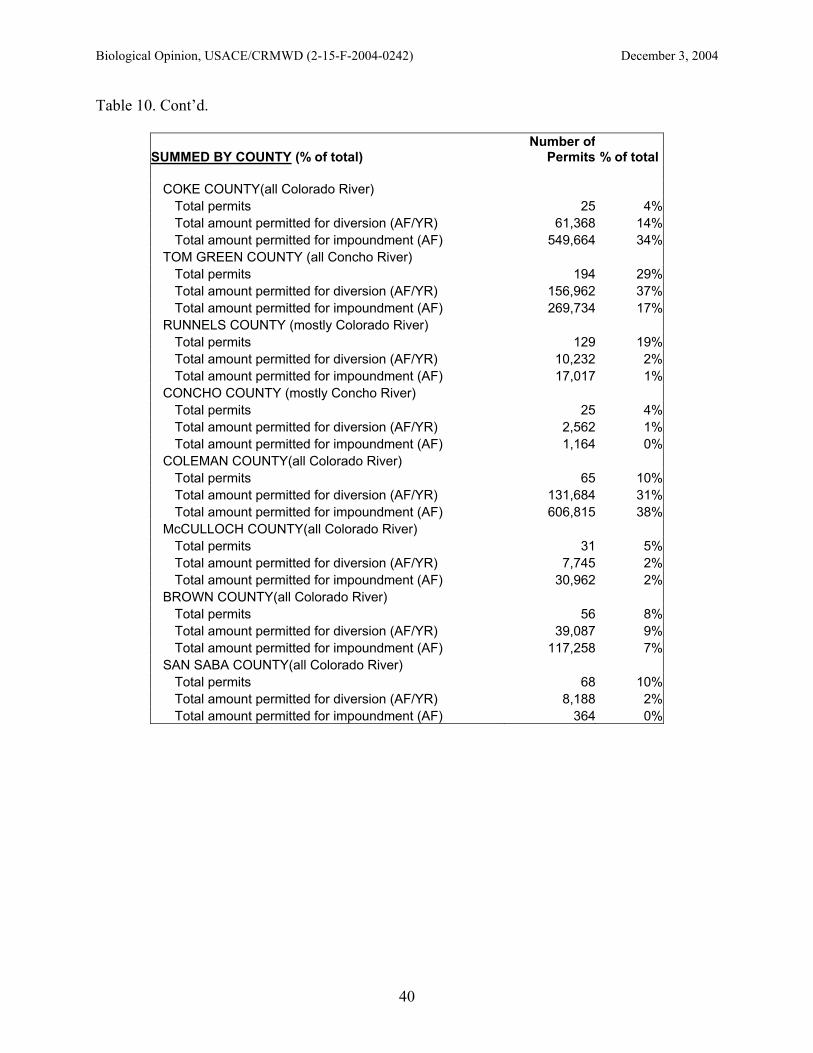
Biological Opinion, USACE/CRMWD (2-15-F-2004-0242) December 3, 2004
40
Table 10. Cont’d.
SUMMED BY COUNTY (% of total) Number of
Permits % of total
COKE COUNTY(all Colorado River) Total permits 25 4%Total amount permitted for diversion (AF/YR) 61,368 14%Total amount permitted for impoundment (AF) 549,664 34%
TOM GREEN COUNTY (all Concho River) Total permits 194 29%Total amount permitted for diversion (AF/YR) 156,962 37%Total amount permitted for impoundment (AF) 269,734 17%
RUNNELS COUNTY (mostly Colorado River) Total permits 129 19%Total amount permitted for diversion (AF/YR) 10,232 2%Total amount permitted for impoundment (AF) 17,017 1%
CONCHO COUNTY (mostly Concho River) Total permits 25 4%Total amount permitted for diversion (AF/YR) 2,562 1%Total amount permitted for impoundment (AF) 1,164 0%
COLEMAN COUNTY(all Colorado River) Total permits 65 10%Total amount permitted for diversion (AF/YR) 131,684 31%Total amount permitted for impoundment (AF) 606,815 38%
McCULLOCH COUNTY(all Colorado River) Total permits 31 5%Total amount permitted for diversion (AF/YR) 7,745 2%Total amount permitted for impoundment (AF) 30,962 2%
BROWN COUNTY(all Colorado River) Total permits 56 8%Total amount permitted for diversion (AF/YR) 39,087 9%Total amount permitted for impoundment (AF) 117,258 7%
SAN SABA COUNTY(all Colorado River) Total permits 68 10%Total amount permitted for diversion (AF/YR) 8,188 2%Total amount permitted for impoundment (AF) 364 0%

Biological Opinion, USACE/CRMWD (2-15-F-2004-0242) December 3, 2004
41
Table 10. Cont’d.
MILLS COUNTY(all Colorado River) Total permits 65 10%Total amount permitted for diversion (AF/YR) 11,449 3%Total amount permitted for impoundment (AF) 2,857 0%
LAMPASSAS COUNTY(all Colorado River) Total permits 22 3%Total amount permitted for diversion (AF/YR) 2,110 0%Total amount permitted for impoundment (AF) 555 0%
Saltcedar. Saltcedar was introduced into the United States in the 1800’s. Saltcedar is reported by Hart (2004) to have four main impacts on the local environment once it is established: (1) increased soil salinity, (2) increased water consumption, (3) increased wildfire frequency, and (4) increased frequency and intensity of flooding. Once established, the plants tend to dominate flood plains. Saltcedar evapotranspiration losses in Region F are estimated at 27.3 to 234 inches/year/plant (69.3 to 594.4 cm/year/plant) or 2.28 to 19.52 acre-feet/acre/year (2,812 to 24,078 cubic meters/acre/year). Initial results indicate that some areas within the Region may benefit from successful and long-range brush control. A review of vegetative cover extent, type of brush, and watershed hydrology indicates that Ivie Reservoir, Lake Spence, and Twin Buttes Reservoir may be likely candidates for brush control. There are currently on-going studies in the North and Middle Concho and the Upper Colorado rivers. There are three ways that brush control can be implemented: physical removal, controlled burns, and chemical kills. Physical removal is labor intensive and so burning or chemicals are typically used. Saltcedar is currently found in the project area in Spence, Ivie, and Twin Buttes reservoirs. Smaller infestations can be found within almost every waterway in the project area. The total infestation in the project area can be measured in the thousands of acres. More than 25 percent of once perennial streams in the Concho and Colorado basins stopped flowing after the drought of the 1950’s when brush such as mesquite, juniper, and saltcedar infested the areas (UCRA 2000). As a result, every 10 acres (4 hectares) of moderate to heavy brush infestation takes one acre-foot of water annually. With the drought of the late 1990’s, additionally perennial streams and major river segments and tributaries have either slowed their flows or ceased flowing. In 1999, the 76th Legislature initiated the North Concho River Brush Control Project to enhance the amount of water flowing from the North Concho River Watershed into O.C. Fisher Reservoir (TSSWCB 2003). Estimates indicate that this project will enhance more than 267,000 acre-feet of water in the North Concho River Watershed over the 10-year life of the project. As of December 2003, almost 59 percent, or 207,537 acres (83,987 hectares), of the 351,689 acres (142,323 hectares) had been treated (TSSWCB 2003). The following effects have been observed thus far: (1) areas where brush control work has been concentrated (Chalk Creek, Grape Creek, Sterling Creek, and Walnut Creek) exhibit more frequent runoff events of greater intensity and duration than other tributaries along the North Concho River; flow responses to rainfall are more
Biological Opinion, USACE/CRMWD (2-15-F-2004-0242) December 3, 2004
42
frequent and pools hold water for longer periods of time following rainfall events; following aerial treatment, a pronounced increase in soil moisture and decrease in evapotranspiration has been observed. In a computer simulation for Ivie Reservoir, values used for average annual rainfall for the Main Concho River Watershed varies from 22.2 inches (56.4 centimeters) in the western portion of the watershed to 25.5 inches (64.8 centimeters) in the eastern portion (UCRA 2000). Average annual evapotranspiration is 22.04 inches (56.0 centimeters) for the brush condition and 20.89 inches (53.1 centimeters) for the no-brush condition yielding 22,527 gallons (85 cubic meters) of water per acre (0.4 hectares) of brush removed per year. Variations in the amount of increased water yield are influenced by brush type, brush density, soil type, and average rainfall. With brush management, the projected average annual flow to Ivie Reservoir increased by 37,636 acre-feet (46 million cubic meters). Reasonable and prudent alternatives from 1986 Biological Opinion. Reasonable and prudent alternatives were developed in the December 1986 biological opinion with the Corps on construction and operation of the Stacy Dam, Reservoir, and pump station on the Colorado River in Coleman, Concho, and Runnels counties. These alternatives were to eliminate jeopardy. There was no critical habitat designated at that time so there was no adverse modification. The principal objective of these alternatives was habitat creation within the snake’s historic range. Based on the Physical Habitat Simulation Program (PHABSIM), Stacy Dam was expected to result in the loss of 1,738,033 ft2 weighted useable area (WUA) of juvenile water snake habitat and the creation of up to 2,629,449 ft2 (WUA) of new habitat. Occupation of the new habitat by Concho water snakes was to be carefully monitored to assure long-term success. Flexibility to test methods of creating the necessary water snake habitat will be provided for in a cooperative agreement. Each of the 1986 Reasonable and Prudent Alternatives are listed below and the results from the District’s actions are provided in brackets [].
I. Monitoring. District was to monitor three times a year in each of the three river reaches isolated by Stacy Reservoir (upper Colorado River, lower Colorado River, and Concho River). Five specific juvenile habitat areas supporting healthy populations of Concho water snakes were to be selected in each reach and used as permanent monitoring sites. Annual reports were to be submitted for ten years. [This activity was completed by the District in 1996. Annual reports were submitted to the Corps and also provided to the Service in 1998 as a part of the petition to delist the snake. The stream channel monitoring requirement was amended in the Service letter dated March 7, 1989. Stream channel sites were established and monitored through 1996. Data was gathered as specified in the March 7, 1989 amendment. Stream channel monitoring results were included in the annual monitoring report submitted to the Corps.]

Biological Opinion, USACE/CRMWD (2-15-F-2004-0242) December 3, 2004
43
II. Studies A. Life history study, including age, growth, reproduction, hibernation, food and feeding, behavior, predation, competition, habitat descriptions and utilization, thermo-regulation and movement. [Life history completed by the Texas A&M Research Foundation (principal investigator J. Dixon). Final annual report submitted to the Corps in 1992. Completed studies resulted in two MS theses and one doctoral dissertation (copies provided to the Service). Growth and thermoregulatory studies completed by N. Scott in 1993 and submitted to the Corps and Service.] B. Genetic viability of the existing population and the isolated subpopulations. [Completed in 1991 by J. Sites and L. Densmore. Final report submitted to the Service.] C. Physical habitat studies, including stream channel stability, sediment source and deposition, vegetation encroachment and water chemistry. [Completed by O. Thornton and submitted to the Corps and Service in 1992.] D. Information on availability and distribution of food items. [Completed annually as a part of monitoring studies by O. Thornton and submitted to the Corps in annual reports. J. Dixon and students also collected information on food distribution and availability which was included in annual reports.] E. Energy budget and growth of all three water snake species (blotched water snake, N. erythrogaster, and diamondback water snake, N. rhombifer) at different life stages under natural and controlled conditions. [Completed by N. Scott in 1993 and submitted to the Corps and the Service.] F. Evaluation of the various proposed management alternatives within this opinion, with recommendations for improvements. [O. Thornton submitted annual (1987-1996) evaluations of prudent alternatives and suggested improvements in annual reports to the Corps and Service.]
III . Upper Colorado River Management. The objectives of this alternative are to reconstruct Concho water snake habitat in the Colorado River from Robert Lee Dam to Maverick and to stop the continued downstream encroachment of silt and vegetation on juvenile foraging areas below Maverick. The following items were required for the rehabilitation.
A. Flow releases from E.V. Spence Reservoir:
1. Minimum Flow. District will release water from E.V. Spence Reservoir at flows sufficient to maintain at least 10 cfs (0.28 cms) throughout the reach of the Colorado River from Robert Lee to the USGS flow gauge at Ballinger. This flow will not be dependent upon presence or absence of flow into the reservoir, is in addition to releases for downstream water rights and shall not be depleted below the 10 cfs (0.28 cms) level by any water user.

Biological Opinion, USACE/CRMWD (2-15-F-2004-0242) December 3, 2004
44
2. Channel Maintenance Flow.
A. To maintain a stable channel morphology, a high flow is needed for flushing of sediments. Although the flow that originally formed the Colorado River channel in this area is no longer possible [15,907 cfs (450 cms) (0.98 days/year)], it is expected that 600 cfs (17.0 cms) released from E.V. Spence Reservoir for a period of 3 consecutive days once every 2 years should be sufficient to maintain a channel of reduced size. This flow must be released during the winter (November through February) to avoid adverse effects on juvenile and hatching Concho water snakes. If insufficient head exists to release 600 cfs (17.0 cms) during the first year of a two year cycle, maximum flows available will be released the second year for the same duration (3 days). District will not be required to release water (as described in this section) during periods of extended drought or conditions that may call for water rationing by the municipalities serviced by District.
B. Channel and habitat rehabilitation: [March 7, 1989 amendment to BO specified six prototype artificial riffles to be constructed. Artificial riffles were completed in August of 1989. Concho water snakes were captured in all six riffles in 1991 and annually thereafter through 1996.]
1. Vegetation and Silt Removal. In order to recreate appropriate juvenile Concho water snake habitat in the upper Colorado River from Robert Lee to near Maverick (30 miles [48 kilometers]), it will be necessary to remove the existing encroaching silt and vegetation from the riffle areas. The requested channel maintenance flow releases are not expected to effectively remove already established vegetation. Mechanical removal is suggested. District should submit a plan for this effort by May 1987 for Corps and FWS review and approval. 2. Addition of Rock. It was deemed necessary to reconstruct rock substrate, from medium gravels to large boulders, by placing rocks laterally and across channel to form bars and riffle areas. The new habitat areas must have shallow water associated with the rock, and a general slope of 10 percent or less. New habitat will be monitored for success and replaced or modified as necessary to ensure long-term success in Concho water snake survival and reproduction.
C. Concho water snake reintroduction. It was not believed that adequate numbers of Concho water snakes would effectively colonize all of the newly created habitat. It would be necessary to move snakes upstream to the restored habitats. Such transplants are to come from the area on the Colorado River to be inundated by Stacy Reservoir and will consist of approximately equal numbers of males and females. This alternative was delayed, due to ongoing genetics studies, with a November 28, 1989, amendment to the biological opinion. [This

Biological Opinion, USACE/CRMWD (2-15-F-2004-0242) December 3, 2004
45
requirement was not necessary to fulfill because Concho water snakes were found occupying all six artificial riffles.]
D. Protection of rehabilitated habitat and existing, minimum, and dominant flows. For long-term maintenance of the rehabilitated habitats and flows, it will be necessary to protect the newly created habitat areas from water and gravel harvesting, low-head dam construction, road and bridge construction and any other channel modification or development that might be proposed. District was to use its legal authorities to prevent water development within the Colorado River channel, and elsewhere in the watershed when such development will impound over 200 acre-feet (247,000 cubic meters). The District also was to discourage water development within the watershed under the 200 acre feet category.
IV. Lower Colorado River Management. Concho water snake habitat in this reach was good from between Stacy Dam and Winchell, fair between Winchell and the Highway 45 Bridge, and unoccupied below Highway 45. The goal of this alternative was to protect the good habitats and to upgrade the fair and unoccupied reaches to good habitats and also to protect proposed critical habitat constituent elements below Stacy Dam.
A. Flow releases from Stacy Reservoir:
1. Minimum Flow. There were to be flows released from Stacy Dam sufficient to maintain 11.0 cfs (0.31 cms) in the Colorado River between April and September, and 2.5 cfs (0.07 cms) between October and March of each year, from Stacy to Pecan Bayou. These flows were not to depend on the presence or absence of water flowing into Stacy Reservoir, and were to be protected from legal and illegal water diversion.
2. Channel Maintenance. District was to assure that the Colorado River below Stacy Dam remains suitable habitat for the Concho water snake by releasing 2,500 cfs (71 cms) under the same criteria for channel maintenance flows that were released from Spence Reservoir (see III A.2). If 2,500 cfs (71 cms) did not flush sediments below Stacy Dam, District would be responsible for mechanical removal.
3. Temperature. Release of waters from Stacy Dam significantly colder than the ambient water temperature of the Colorado River will result in the death of many water snakes and most of the forage fish for many miles downstream. Release of deep cold waters from Stacy Reservoir during the summer months when ambient river water temperatures could be 80°F (27°C ) must not occur. When the reservoir is stratified, all releases will come only from the warmer, epilimnetic surface waters.

Biological Opinion, USACE/CRMWD (2-15-F-2004-0242) December 3, 2004
46
B. Habitat Improvement
1. Stacy Dam to Winchell. Changes in water flows after construction of Stacy Dam were expected to reduce Concho water snake habitat in this reach by 186,758 ft2 weighted useable area (WUA). However, the river was not expected to aggrade as happened below Spence Reservoir because of differences in soil type and land management practices below Stacy. Snakes are expected to remain in this reach of the river at reduced numbers corresponding to the reduced habitat.
2. Winchell to Pecan Bayou. From Winchell to Pecan Bayou, the Colorado River changes its bedrock strata and enters an area of extensive sandstone. Snakes and riffle habitats were found in the first 24 miles (38.6 kilometers) of this formation at a reduced rate. Numerous low head dams or gabions were to be constructed, to create new riffles. Reaches of the Colorado River below Pecan Bayou were not recommended for improvement because sustained maintenance of riffle habitats might be physically impossible due to floods and siltation. [This alternative was eliminated in the March 7, 1989, amendment to the BO.]
V. Concho River Management. In 1986 there were 19 low head dams (some exceeding 6 feet in height) on the Concho River below San Angelo. These dams interrupt gravel transport downstream, inundate long stretches of river, and may hinder snake movement. The District was to determine the feasibility of removal of each of these low head dams. [An investigation of the ownership and status of all 19 low-head dams was completed by O. Thornton in 1987. A report was submitted to the Corps and the Service. Removal of these dams was not recommended pending further study.]
VI. New Reservoir Habitats, Stacy Reservoir Management. In order to replace habitat lost due to Stacy Reservoir, habitat along the new reservoir shore must be made more suitable for Concho water snakes by constructing 45 new reservoir habitats. [This alternative was deleted by a March 7, 1989, biological opinion amendment because the Concho water snake colonies were found in Lake Spence and Lake Moonen. Additional basking areas were to be provided within the reservoir by allowing the larger trees to stand rather than removing them.]
VII. Tributary Stream Habitats. While loss of prime water snake habitat and proposed critical habitat in the Colorado and Concho Rivers was partially offset by habitat improvements above and below Stacy Reservoir, additional secure habitat was needed. Several of the smaller tributaries of the Colorado and Concho Rivers were known or believed to support Concho water snakes. [District personnel captured 5 Concho water snakes in Elm Creek and its tributary, Coyote Creek in 1986. Kickapoo Creek, Spring Creek, and perhaps Lipan Creek may still support a few Concho water snakes. The District was to negotiate with private land owners for protection of Elm Creek and its tributary in the area of suitable water snake habitat, about 7 miles (11 kilometers).]
VIII. Maintenance of Genetic Heterogenity. It was surmised that the isolation of Concho water snake populations by Stacy Reservoir could result in a loss of genetic diversity so it

Biological Opinion, USACE/CRMWD (2-15-F-2004-0242) December 3, 2004
47
appeared necessary to move snakes from one population to another. At least five female Concho water snakes were to be transferred to each of the 3 isolated populations from its nearest neighboring population once each year during mid summer.
IX. Employment of a Full-Time Biologist. District was to hire a full-time biologist for ten years to oversee the implementation of the alternatives. [Completed with hiring of O. Thornton in 1987.]
X. Cooperative Agreement. An agreement was to be signed by the principal parties to assure that all phases of the biological opinion would be carried out before and after construction of Stacy Dam. It was believed that if habitat creation and improvement measures set forth by the Reasonable and Prudent Alternatives were successfully completed and occupied by Concho water snakes, a maximum total of 2,629,449 ft2 WUA of juvenile foraging habitat will be created. The total gain represented a recovery of 161 percent over the total losses of 1,637,308 ft2 WUA to the Stacy project, and will increase existing habitat from current 6,311,788 ft2 WUA to 7,203,204 ft2 WUA.
1986 Reasonable and Prudent Measures. The 1986 biological opinion also contained a reasonable and prudent measure to reduce take: a District employee was to be on hand at times when take was likely to occur, to salvage snakes. Terms and conditions of incidental take were: (1) that the District notifies the Service prior to any activity likely to result in take; (2) that any snakes salvaged be immediately reported to the Service or placed as per prior agreement with Service; and (3) any Concho water snake mortalities be reported to the Service. IV. Effects of the Action Introduction. As mentioned previously, the Action that is the subject of this consultation is an emergency situation affecting human health and safety. The District (September 2004 letter to the Service), using their expert judgment, believes the conditions that caused this emergency will end when both Spence and Ivie reservoirs are at 50 percent of capacity. The intent of this biological opinion is to add the latest scientific information to the analysis of effects both on the species and its critical habitat, as it was originally designated, and to use this new information to analyze effects and to draw conclusions on the effects of the action. a. Factors to be considered Threats. Both the Brazos and Concho water snakes have a historic range of the upper reaches of large central Texas rivers. The hypothesis is that an ancestor water snake of the Nerodia fasciata lineage evolved to occupy a niche in these prairie rivers and an environmental change caused the Brazos and Concho forms to be isolated from one another. The Concho water snake occupies a restricted geographic range in the Concho and Colorado River Basins in central Texas and is completely contained within the proposed action area. Optimal habitat is believed to be free-flowing streams over rocky substrates periodically scoured by floods (which provide relatively sediment free rock rubble and open banks), abundant rock debris and crevices for shelter, and the

Biological Opinion, USACE/CRMWD (2-15-F-2004-0242) December 3, 2004
48
shallow riffles where juveniles are most commonly found. All size classes of the species forage almost exclusively on small fish, so habitat for the prey species is also important. When the Concho water snake was listed in September 1986, the primary threats were believed to be destruction, modification, or curtailment of its range. The final rule noted that habitat was affected by four large mainstream reservoirs on the Concho and Colorado rivers. The rule stated that above dams the Concho water snake habitat was inundated and below dams the normal run-of-the-river was curtailed and scouring of the river bed by flood flows was prevented. Without the scouring flows, the streambed captures silt and vegetation, including saltcedar that becomes established, burying the rocky streambed. In December 1986 the Service provided a biological opinion to the Corps for a permit to the District that would facilitate the construction and operation of the S.W. Freese Dam (Stacy Dam) and reservoir (O.H. Ivie Reservoir). The Service concluded that the proposed action was likely to jeopardize the continued existence of the Concho water snake and proposed reasonable and prudent alternatives. Habitat related requirements included:
• Maintain a continuous daily flow of at least 10 cfs (0.28 cms) in the Colorado River from Spence Reservoir to Ballinger,
• Provide a flushing flow of at least 600 cfs (17 cms) from Spence Reservoir for a duration of 3 consecutive days sometime between November 1 and February 28,
• Maintain a continuous daily flow of 11 cfs (0.31 cms) in the Colorado River between Freese Dam and Pecan Bayou between April and September,
• Maintain a continuous daily flow of 2.5 cfs (0.07 cms) in the Colorado River between Freese Dam and Pecan Bayou between October and March, and
• Provide flushing flows of 2,500 cfs (71 cms) from Ivie Reservoir for 2 consecutive days at least once every 2 years.
In June 1989, the Service designated critical habitat for the threatened Concho water snake. Included were a portion of the Concho River below San Angelo and portions of the Colorado River above and below Ivie Reservoir. The Colorado River above and below Spence Reservoir, and Spence Reservoir, were not included. A long stretch of Colorado River above Lake Buchanan was not included. The Service included the Ivie Reservoir basin because “the potential for the snake to inhabit Ivie Reservoir appears significantly greater than previously thought.” The Service also included one-half mile (0.8 kilometers) of the streams and other tributaries upstream from their confluences with the Concho and Colorado rivers or Ivie Reservoir. Within the boundaries of the designated critical habitat, the Service recognized the following primary constituent elements:
• Shallow riffles and rapids with rocky cover, • Minimum stream flows,
Continuous daily flow of 10 cfs (0.28 cms) in the Colorado River from E.V. Spence Reservoir to Ballinger, Texas
Flushing flow of 600 cfs (17 cms) from E.V. Spence Reservoir for a duration of 3 consecutive days at any time during the months of November through February, at least every other year
Continuous daily minimum flow of 11.0 (0.31 cms) cfs in the Colorado River

Biological Opinion, USACE/CRMWD (2-15-F-2004-0242) December 3, 2004
49
between Freese Dam and Pecan Bayou between April and September each year, and a minimum of 2.5 cfs (0.07 cms) between October and March of each year, and
Flushing lows of 2,500 cfs (71 cms) from Ivie Reservoir for 2 consecutive days at least once every 2 years for channel maintenance.
• Dirt banks, • Rocky shorelines, and • Woody riparian vegetation.
A final recovery plan for the Concho Water Snake was completed in 1993 (USFWS 1993). The recognized threats to the Concho water snake included: (1) habitat loss and degradation resulting from: (a) reservoir inundation and (b) modifications to flow regimes related to water diversion and/or impoundment; (2) pollution or degradation of water quality in the Concho and Colorado rivers or tributaries; (3) fragmentation and isolation of populations following habitat disturbances; (4) loss of adequate instream flow due to natural and/or man-made conditions; and (5) sediment loading and deposition coupled with vegetation encroachment of rocky/bedrock riffle habitats used by Concho water snakes.
However, subsequent to the finalization of this recovery plan, new information has indicated that some of these threats have decreased in significance (Dixon 2004), and that a new threat exists, reduction of snake habitat by saltcedar (Thornton, pers. comm., 2004). Recovery strategy. The 1993 recovery strategy relied on maintenance of adequate instream flows to maintain both the quantity and quality of Concho water snake habitat so that occupied habitat would continue to support viable populations of the Concho water snake. Actions were designed to insure that a combination of natural and/or man-made factors did not result in inadequate instream flows, which it was believed could have adverse effects on the Concho water snake, its habitat, and prey base. Additionally, time was needed to evaluate changes such as sedimentation and the adequacy of current flushing flows (related in part to reservoir development) on Concho water snake habitat. Recovery plans are guidance documents and are based on an adaptive management strategy. As new and better information becomes available, recovery plans are amended. New information on the habitat needs of the Concho water snake is now available (Dixon 2004) and has altered our understanding of the recovery needs of the Concho water snake. Reservoir habitat and habitat provided by low-head dams have been shown to provide important buffers during extended drought. b. Analyses for Effects of the Action The effects of the proposed action are primarily a result of direct effects (the immediate effects of the project on the species or its habitat) that will be ongoing for the life of the project and some time after and encompass the entire range of the Concho water snake. The primary negative effects to the Concho water snake and its designated critical habitat are related to the changes in reservoir operations and the resulting releases to the Colorado River downstream.

Biological Opinion, USACE/CRMWD (2-15-F-2004-0242) December 3, 2004
50
Reservoir inundation. Concho water snakes have been shown to maintain reproducing populations in reservoir environments by using rocky shorelines that are similar in substrate structure, water depth, and availability of fishes for prey. During the District’s 10-year monitoring effort, snakes were regularly found in Spence, Ivie, and Moonen reservoirs. Surveys in 2004 have confirmed that snakes persist in Spence and Ivie reservoirs, although lack of inflow to Lake Moonen may have resulted in their extirpation there (Dixon 2004). As a result of the Service designating Ivie Reservoir as critical habitat for the species and the fact that the snake has continued to reproduce and persist in lake and reservoir habitat, the threats from reservoir inundation are no longer considered significant to the conservation of the snake. District estimates suggest that 18 percent of the total available habitat to the snake range-wide is provided in these two reservoirs (see discussion in Sec. III, Status of the Concho water snake, page 4 and Appendix B). Changes in the water surface elevation of the reservoirs (Spence and Ivie) do affect the availability of shoreline habitat for the snake (Whiting 1993). There is not a quantified relationship of snake habitat to reservoir levels. It appears that shallow, rocky shoreline habitat, inhabited by prey fishes, are available throughout the range of potential reservoir stages (Dixon 2004). Reservoir habitats may be altered due to the proposed action; however, the overall available snake habitat should not be measurably affected. Reservoir levels may increase as a result of decreasing minimum flow releases, which would provide more shoreline miles of potential habitat. Stream flows. The impact to stream flows as a result of the proposed action is not a range-wide phenomenon that will affect the Concho water snake throughout its present distribution. The proposed action will have no effect on instream flows in the river segment above E.V. Spence Reservoir. Nor will this action have an effect on the Concho River segment between San Angelo and O.H. Ivie Reservoir. Only the Colorado River segments between Spence Reservoir and Ivie Reservoir and below Ivie Reservoir will be affected because of the proposed action. It should be noted that although there will be an effect, the impact from the effect will be ameliorated to some degree by the nature of the intervening watersheds that drain each of these stream segments. The upper Colorado River basin is characterized as being xeric in nature, replenished by flood events, and supplemented by numerous tributaries, some of which are perennial but most being intermittent. Both the Colorado River and Concho River are "gaining" streams, i.e., as you progress downstream, these rivers "gather" water. This "gathering" of water is exhibited not only by tributary inflow but also as bank discharge from spring flow that occurs where shallow aquifers interface with the stream. This "gaining" stream phenomenon is greatly controlled by ambient weather conditions. During periods of long-term drought, the tributaries and springs will cease flowing. During normal rainfall periods, these sources of water help to restore and maintain a more stable instream flow. O. Thornton (pers. comm., October 2004) believes some instream flows will return once the long-term drought is over. Based upon his experience in the upper basin, the stream segment between Spence and Ivie will see flows augmented by intermittent discharge from Messbox Creek (near Robert Lee), Oak Creek, Valley Creek, Elm Creek, and Mustang Creek. Post-drought conditions may exhibit continual discharge from the confluence of Oak Creek with the

Biological Opinion, USACE/CRMWD (2-15-F-2004-0242) December 3, 2004
51
Colorado River downstream. The Elm Creek watershed is a significant tributary and it is now providing a constant inflow into the Colorado River at Ballinger. The Concho River has five noteworthy tributaries that will augment flows after drought conditions have been relieved. These streams are the Lipan Creek, Dry Hollow, and the Kickapoo Creek, all of which drain into the river above Paint Rock. The downstream segment of the Colorado River below the Freese Dam will experience nearly constant flow beginning roughly at the mouth of Panther Creek. This is nearly 2 miles downstream of the FM 503 crossing and approximately 14 miles downstream of the Freese Dam. Mustang Creek (Concho County) drains into this segment approximately 3 miles below Freese Dam and its watershed has periodically provided significant inflows into the Colorado River. Below the mouth of Panther Creek, and above US 377 (Winchell), Salt Creek, and Home Creek, are two significant tributaries that will also provide augmenting flows to the Colorado River. Below Winchell significant instream flows are received from Pecan Bayou, the San Saba River, and Cherokee Creek, plus numerous other minor tributaries. A flow simulation was conducted to evaluate the potential changes in downstream flows in the Colorado River from Spence Reservoir as a result of the proposed action to decrease the magnitude and frequency of releases from the dam. This simulation used the recorded 1999 to 2004 stream discharges, published by the USGS, to predict the downstream discharge based on the District’s proposed operations (Appendix C). The simulation is preliminary and may be revised prior to finalization of this biological opinion. This time period was used because it represents a period of extreme drought coupled with the possible effects of the action on Concho water snakes. The results indicate flows under the proposed action would decline compared to the actual data under previous minimum flow releases. For example, the median annual flow at Ballinger from 1999 to 2003 was 8.6 cfs. Under the proposed action the median flow would have been 0.8 cfs. The percent of no flow days at Ballinger would increase from 0 with the actual data to 50 percent under the proposed action. This would affect the riverine sections of the habitat below Spence and Ivie reservoirs downstream to where flows would be naturally augmented by intervening watershed inflows (see discussion above). The proposed actions would decrease flows often during the mid to late summer (July-August) at the time when female Concho water snakes would be gestating and bearing young. However, historical USGS records indicate the river flow during this time of the year (July through August) is characterized by periods of low to no discharge. This is typical of the arid region the upper Colorado River drains. Although this decrease in flow will likely reduce the amount of available shallow, rocky habitats in much of the river, it is our belief that the Concho water snake has evolved and adapted to this environment over the past several million years and is well equipped to endure and survive these conditions. The extent of the habitat degradation, in river area and duration, is largely dependent upon the climatic conditions. In severe drought, as the region has experienced during much of the previous decade, the linear extent of dewatered riverine habitats could be large and the length of time without adequate flows could extend for several months or more. This was recently noted by Dixon (2004) in his observation that Elm Creek had experienced no flow conditions for a period of three years and yet Concho water snakes were found shortly after a flood event restored stream flow in the creek.

Biological Opinion, USACE/CRMWD (2-15-F-2004-0242) December 3, 2004
52
Dixon (2004) theorizes that Concho water snakes will utilize remaining pools, particularly upstream of low-head dams, during low flow times. So long as there is some water and fish available for prey, snakes are likely to survive under such conditions for some time period (Dixon 2004). Population fragmentation. Past actions to construct large reservoirs (Ivie, Spence, O.C. Fisher and Twin Buttes reservoirs) have likely resulted in the segmenting of populations of Concho water snakes. J. Dixon (pers. comm., August 2004) does not believe Concho water snakes travel overland to circumvent the barriers caused by the large dams. Therefore, based on the best information currently available, the large dams probably fragment the species’ genetic interchange. The proposed action is limited to the operation and maintenance of District facilities and should not result in further fragmentation or isolation of snake populations. The genetic variability of the Concho water snake was investigated and documented by Sites and Evans (1990) and Sites and Densmore (1991). The results of these and other studies (Lawson 1987; Rose and Selcer 1989) indicated the Concho water snake (and other species of Nerodia) is characterized by very low levels of protein polymorphism. Furthermore, the relatively high diversity of mtDNA haplotypes they found within the subspecies, both within and between metapopulations sampled from a major part of the total range, suggests that population densities are generally high and that, while metapopulations are structured, gene flow among them is sufficient to maintain at least some common haplotypes throughout most or all of the range even with the reservoir barriers. Estimates by Sites and Densmore (1991) further indicated a minimum amount of genetic diversity could be lost from the total Concho water snake gene pool with the filling of Ivie Reservoir, and they concluded that the potential genetic loss resulting from the completion of the reservoir project (Freese Dam) would be inconsequential. Regardless of these conclusions, the Service believes that the transfer of five male Concho water snakes above and below both the Robert Lee and Freese dams once every three years would be sufficient to maintain genetic heterogeneity between these separated metapopulations. However, it would not be necessary to transfer snakes between the Concho River and the upper reach of the Colorado River above Ivie Reservoir. Water quality / pollution. Impacts from water quality degradation and pollution remain a potential threat; however, no impacts have been observed or documented as a result of water quality conditions during the past 12 years of an extreme, long-term drought. The likelihood of impacts to the snake and small fish from chronic water quality degradation or the introduction of contaminants does increase with the proposed action as the riverine reaches decline in flows, the ability to dilute or transport pollutants decreases. However, it should be noted that the District has a very comprehensive water quality monitoring program in the upper Colorado River basin that includes the distribution of the Concho water snake above the Freese Dam. The Lower Colorado River Authority (LCRA) has the responsibility for water quality monitoring below the Freese Dam. Both of these entities have participated in the Clean Rivers Program since 1991 and have provided a proactive responsibility for ensuring a high level of surface water quality in the Colorado River and its mainstem reservoirs. These programs are ongoing and designed to ensure the water quality integrity for all aquatic resources in the upper basin. As water quality problems are detected, swift responses by the District and the LCRA to effect corrective actions

Biological Opinion, USACE/CRMWD (2-15-F-2004-0242) December 3, 2004
53
through State of Texas regulatory agencies (TCEQ and the Texas Railroad Commission) are completed. Sedimentation. As a result of regulated flows and lack of large rainfall events, and the increase in saltcedar, the Colorado and Concho rivers have seen increases in the amount of sedimentation in riffle areas that serve as Concho water snake habitats, particularly for neonates. This is a long-term, ongoing alteration in the geomorphology of the river and will likely continue under the proposed action. Without significant rainfall events in unregulated watersheds, flushing flows will not be available to transport sediments and scour riffle areas of encroaching vegetation. Dixon (2004) suggests that the Concho River needs a flow in excess of 15,000 cfs to reset the river channel and restore former riffle areas. It is unknown if the river habitat will be returned to pre-drought conditions, without sediment, grass, and shrubs replacing the rocky substrate. District annual monitoring reports noted that in many cases, intense use by cattle helped maintain the riffle habitat. However, this activity is a "double-edged sword" in the riparian areas of the river basin. O. Thornton (pers. comm., October 2004) has observed in his experience over the past 15 to 20 years that livestock use of the river, though beneficial in helping to control riffle vegetation, has aggravated channel sedimentation by creating barren pathways (i.e., cattle, sheep, and goat trails) that contribute to erosion and sediment load during intense rain and runoff events. Critical habitat. The original primary constituent elements related to stream habitats and minimum flows will likely be impacted by the proposed action. However, our understanding of habitat utilization by the Concho water snake has been substantially changed. It is now known that the snake uses areas upstream and downstream of low-head dams, and is not solely dependent on riffles for foraging (Dixon 2004). Lower than the original required flows are expected to occur in both reaches of the Colorado River. The amount of available shallow, rocky, riffle habitats is likely to be reduced as a result of the proposed action. Reservoir habitats will be affected by the proposed action, but the net change in functionality of the reservoirs is not expected to be great. c. Species' Response to Proposed Action Snake populations. Because we do not have any data on snake populations to formulate trends or current status, it is difficult to quantify the future impacts on the snake of the proposed action. Certainly decreased or loss of flows in the Colorado River will have some affect on the Concho water snakes by limiting their prey species and habitats. Beneficial actions proposed by the District including saltcedar removal and riparian rehabilitation/restoration should counter balance these negative effects. Additionally, when drought conditions subside, increases in precipitation will provide benefits to the species. Likewise, as the reservoirs increase in stored volume, the miles of potential shoreline habitat for the snake will increase and the flooding of vegetated shoreline will have short-term benefits by providing an abundance of habitat and forage for small fish. It is difficult to predict when these benefits will occur. Critical habitat. The 1986 biological opinion required continuous daily flows of 10.0 cfs in the

Biological Opinion, USACE/CRMWD (2-15-F-2004-0242) December 3, 2004
54
Colorado River from E.V. Spence Reservoir to Ballinger, Texas, and continuous daily minimum flows of 11.0 cfs in the Colorado River between Freese Dam and Pecan Bayou between April and September each year. The 1989 designation of critical habitat reiterated these flows as primary constituent elements of critical habitat. At the times the 1986 biological opinion and the 1989 designation of critical habitat were finalized, our knowledge of the habitat needs of the Concho water snake was incomplete. Subsequent work, especially the many studies done in the early 1990’s, has greatly added to our knowledge. It is now known that the Concho water snake is more of a habitat opportunist than originally believed (Dixon 2004). In addition to reservoir and riverine habitat, the snake is known to use areas above and below low head dams, pools created by the dams, man-made lakes, naturally occurring pools in the river, and tributaries, as Concho water snake has been found in Elm Creek and two of its tributaries. Without doubt the riverine habitat is an important type of habitat but the need for continuous flows of 10.0 cfs or greater cannot be substantiated. The amount of reservoir critical habitat will increase as the water level in the reservoirs increase because the amount of shoreline habitat will increase. However, the rocky substrate preferred by the Concho water snake is sporadically distributed and it is uncertain whether a linear relationship between reservoir level and Concho water snake habitat exists. Reservoirs will continue to provide important habitat for the about 18 percent of the snake population that occurs there, especially during times of drought and will likely provide a source of snakes for translocation purposes. Critical reservoir habitat could be better defined as the shallow water areas sheltered from intense wave action, where rocky habitat, especially flat slab rock, is present and vegetation is present as habitat for small fish. Beneficial Actions. A new, albeit indirect, threat to the snake, not identified at the time of listing or critical habitat designation, has been the invasion of saltcedar. The 1986 final rule that listed the Concho water snake as a threatened species mentioned saltcedar as one of the species that became established but did not recognize saltcedar specifically as a threat. We now know that saltcedar has multiple negative effects. Saltcedar consumes great quantities of water and thus reduces the water available to the river and its tributaries. Saltcedar produces quantities of salt and can degrade water quality thus possibly affecting snake prey items. Saltcedar forms dense monotypic stands of vegetation that out competes and replaces native species, thus altering key functions of the ecosystem. Saltcedar control. Computer modeling has shown that the entire Colorado and Concho river basins could gain 249,584 acre-feet (308 million cubic meters) of annual groundwater recharge and surface water flow into existing reservoirs (UCRA 2000). Two reservoir basins, Ivie and Twin Buttes, could realize almost 155,000 acre-feet (191 million cubic meters) of water annually in groundwater recharge and surface flow through brush control (UCRA 2000). In this computer simulation for Ivie Reservoir, values used for average annual rainfall for the Main Concho River Watershed vary from 22.2 inches (56 centimeters) in the western portion of the watershed to 25.5 inches (65 centimeters) in the eastern portion (UCRA 2000). Average annual evapotranspiration is 22.04 inches (56 centimeters) for the brush condition and 20.89 inches (53 centimeters) for the
Biological Opinion, USACE/CRMWD (2-15-F-2004-0242) December 3, 2004
55
no-brush condition yielding 22,527 gallons (85 cubic meters) of water per acre (0.4 hectares) of brush removed per year. Variations in the amount of increased water yield are influenced by brush type, brush density, soil type, and average rainfall. With brush management, the projected average annual flow to Ivie Reservoir increased by 37,636 acre-feet (46 million cubic meters). As of 2004, it is estimated that roughly 16,000 acres (6,500 hectares) of District lake basins are infested with saltcedar (Okla Thornton, District, pers. comm., 2004). The Colorado River and its main tributaries are estimated to have an additional 6,000 to 8,000 acres (2,400 to 3,200 hectares). The impact of saltcedar to water resources has been well documented. A single, mature tree can consume up to 200 gallons (0.8 cubic meters) of water per day (McGinty et. al. 2004). Several studies have demonstrated that one acre (0.4 hectares) of moderate size saltcedar trees (6 to 10 feet [2 to 3 meters] tall) can transpire anywhere from 2 to 12 acre-feet (2,500 to 15,000 cubic meters) of water in an annual growing season (April to October) (Okla Thornton, District, pers. comm., 2004). Considering the number of acres of saltcedar in the upper Colorado River basin, this translates into an incredible amount of water that can be recovered with a saltcedar control program. As part of the proposed project, the District will provide support for saltcedar control in the upper Colorado River watershed, including the Concho River. The District is cooperating in a saltcedar control project funded by the EPA through a Clean Water Act, Section 319(h) grant to the TSSWCB. An actual test of saltcedar removal and commensurate water production was done on the Pecos River and reported in 2001 (Hays 2003). During the first year, estimated annual water use by saltcedar and associated vegetation (using a specific yield of 10 percent) varied from a low of 2.3 acre-feet/year (2,800 cubic meters/year) to a high of 7.0 acre-feet/year (8,600 cubic meters/year), averaging 4.9 acre-feet/year (6,000 cubic meters/year). Based on a value of 4.9 acre-feet/year (6,000 cubic meters/year), control of saltcedar on the Pecos River site (2,774 acres) resulted in an annual water savings of 13,593 acre-feet (17 million cubic meters) (assuming 100 percent control of the vegetation and no water use by replacement vegetation). The removal and control of saltcedar from the riparian reaches of the Colorado and Concho Rivers will help to augment existing stream discharge and also reduce the buildup of dissolved solids (salts) in the soils of the riparian zone. A test project to evaluate the use of fixed wing and rotary wing aircraft to aerially treat saltcedar within the upper Colorado River Basin was done in 2003 (McGinty et al. 2004). During September 2003, both aircraft types were used to apply various herbicides at various speeds and volumes to saltcedar within the Lake Spence basin. In a draft report, McGinty et al. reported that one-year following application, excellent control (97 percent) was achieved with Arsenal (1 pound/acre) when applied by fixed wing aircraft. Control with Cimarron Max (Rate 3) was much less (22 percent). As a result, aerial application of the herbicide Arsenal (BASF) will be used to make the initial control of the saltcedar in the watershed above the Robert Lee Dam (E.V. Spence Reservoir). Treatment had been scheduled to begin in September 2004, but early senescence of saltcedar trees (possibly because of cool temperatures) prevented this initial treatment. The next scheduled treatment is in September 2005. This Arsenal treatment at 0.5 gallons/acre applied by helicopter will be from the Lake Thomas Dam to the Spence lake basin and will include Beals Creek, totaling approximately 2,800 acres (1,100 hectares) (pers. comm., Tuffy Wood, 2004). The treatment will include two segments. Segment one will be approximately 75 miles (120
Biological Opinion, USACE/CRMWD (2-15-F-2004-0242) December 3, 2004
56
kilometers) by 150 feet (46 meters) in the Colorado River and will include Bull, Bluff, Deep, Willow, Champion, and Morgan creeks for a total of 1,544 acres (625 hectares). Segment two will be 64 miles (100 kilometers) by 100 feet (30 meters) on Beals Creek; 25 miles (40 kilometers) by 150 feet (46 meters) on the Colorado River; and from the confluence of Beals Creek to the mouth of Lake Spence, for a total of 1,231 acres (500 hectares). In 2006, the Lake Spence basin will be treated by the same method for a total 7,000 acres (2,800 hectares). There is an estimated 7,000 acres (2,800 hectares) of saltcedar within the Lake Spence basin and 9,000 acres (3,600 hectares) within the Ivie Reservoir basin. If the Pecos River results are applicable, that would mean saving 83,300 acre-feet (102 million cubic meters) of water per year. It is anticipated that this would recharge the river basin thus providing additional instream flows. Bio-control is planned to be used for follow-up maintenance control. The U.S. Department of Agriculture – Agricultural Research Service is releasing saltcedar leaf beetles in selected areas of the upper Colorado River basin. Prospects for long-term maintenance control with the Asian leaf beetles appear hopeful. Summary. Although decreased flows during the human health and safety emergency period are affecting riverine habitat used by the Concho water snake, increased flows once the drought has ended, along with water savings and replenishment that will result from large-scale saltcedar control and riparian habitat rehabilitation/restoration should combine to help restore the riverine habitat and sustain the snake. A method of restoring the degraded riffle habitat may be needed. The most natural method would be to use scouring flows, that is, flows of great volume but short duration that would wash the sediments and vegetation off of the rocks. However, it is not known if stored water volumes and natural rain events will ever allow scouring flows of the magnitude needed. It has been suggested that a natural flood flow in excess of 10,000 cfs (283 cms) would more than likely be required (Thornton, pers. comm. August 2004). However, Thornton recalled a flood event on the Concho River in 1989 with a measured (USGS) discharge of greater than 10,000 cfs (283 cms) that failed to significantly remove vegetation and sediment in the river at the Concho low water crossing. V. Cumulative Effects Cumulative effects include the effects of future State, tribal, local or private actions that are reasonably certain to occur in the action area considered in this biological opinion. Future federal actions that are unrelated to the proposed action are not considered in this section because they require separate consultation pursuant to section 7 of the Act. Water use and availability for humans and for the environment will be the driving factors of the cumulative effects. The 33 county Region F water planning area experienced a 1.3 percent annual growth rate, going from 81,985 in 1900 to 590,618 in 1998. The total water supply for the Region F area is 713,000 acre-feet, and in 2000 the demand was 881,500 acre-feet. Total demands for Region F are projected to increase from 881,500 acre-feet in 2000 to 900,200 acre-feet per year in 2050. The largest demand category is irrigation, which accounts for nearly 75

Biological Opinion, USACE/CRMWD (2-15-F-2004-0242) December 3, 2004
57
percent of the total demand. The demand exceeds the available supply by over 170,000 acre-feet per year in 2000, increasing to 200,000 acre-feet per year by 2050. Water use in 1996 and projected 2050 water demand for the Region F counties in the project area are (acre-feet/year): Coke – 2,788 and 3,041; Runnels – 11,427 and 11,192; Tom Green – 79,299 and 163,384; Coleman – 5,085 and 4,512; Concho – 6,168 and 8,701; McCulloch – 6,021 and 8,000; and Brown – 23,121 and 20,692. Total firm yield (acre-feet) for the District’s Thomas, Spence, and Ivie reservoirs for 1997 and projected 2050 are 151,800 and 138,262, respectively. Firm yield is the annual amount of water that could reliably be obtained during a repeat of the worst historical drought experienced in the period of available hydrologic record leaving no reserves. The City of San Angelo receives municipal water supply from Twin Buttes and O.C. Fisher reservoirs, as well as supplemental water from the District. The City can provide water to the Concho River through waste water discharges. Figure 4 shows the projected future water pumpage and usage for the City of San Angelo. Figure 4. San Angelo water pumpage and usage, 1998 to 2003, and projected through 2010.
SAN ANGELO WATER PUMPAGE -- WATER USAGE
22773
21786
1971119326
16987
1585219637
1773817081
1498814491
13883
1530015211
1507314933
1479114674 14606
1346413386 13415 13439 13460
13328 13438
0
5000
10000
15000
20000
25000
1998 1999 2000 2001 2002 2003 2004 2005 2006 2007 2008 2009 2010
YEAR
AC
RE-
FEET
Raw Water Pumpage Metered Water Sales Projected Water Pumpage Projected Water Sales
VI. Conclusion After reviewing the current status of the Concho water snake and it’s designated critical habitat, the effects of the proposed operation and maintenance of the District’s water supply system, and the cumulative effects, it is the Service's biological opinion that the proposed action, is not likely to jeopardize the continued existence of the Concho water snake, and is not likely to destroy or adversely modify designated critical habitat.

Biological Opinion, USACE/CRMWD (2-15-F-2004-0242) December 3, 2004
58
INCIDENTAL TAKE STATEMENT
Section 9 of the Act and Federal regulation pursuant to section 4(d) of the Act prohibit the take of endangered and threatened species, respectively, without special exemption. Take is defined as to harass, harm, pursue, hunt, shoot, wound, kill, trap, capture or collect, or to attempt to engage in any such conduct. Harm is further defined by the Service to include significant habitat modification or degradation that results in death or injury to listed species by significantly impairing essential behavioral patterns, including breeding, feeding, or sheltering. Harass is defined by the Service as intentional or negligent actions that create the likelihood of injury to listed species to such an extent as to significantly disrupt normal behavior patterns which include, but are not limited to, breeding, feeding or sheltering. Incidental take is defined as take that is incidental to, and not the purpose of, the carrying out of an otherwise lawful activity. Under the terms of section 7(b)(4) and section 7(o)(2), taking that is incidental to and not intended as part of the agency action is not considered to be prohibited taking under the Act provided that such taking is in compliance with the terms and conditions of this incidental take statement. The measures described below are non-discretionary, and must be undertaken by the Corps so that they become binding conditions of any grant or permit issued to the District, as appropriate, for the exemption in section 7(o)(2) to apply. The Corps has a continuing duty to regulate the activity covered by this incidental take statement. If the Corps (1) fails to assume and implement the terms and conditions or (2) fails to require the District to adhere to the terms and conditions of the incidental take statement through enforceable terms that are added to the permit or grant document, the protective coverage of section 7(o)(2) may lapse. In order to monitor the impact of incidental take, the District must report the progress of the action and its impact on the species to the Service and the Corps as specified in the incidental take statement. [50 CFR '402.14(i)(3)] Amount or Extent of Take Anticipated The Service anticipates incidental take of Concho water snakes may occur in the form of (1) harm to the species by habitat alteration that may impair sheltering, breeding and feeding behaviors and (2) harm to the species by limited genetic exchange due to the high dams preventing the species’ upstream movement. It will be difficult to detect the take of individual snakes for the following reasons: the species is wide-ranging; finding a dead or impaired specimen is unlikely; losses may be masked by seasonal fluctuations in numbers or other causes; the species occurs in aquatic habitats that make detection of individuals unrealistic; and the harm may be in the form of reduced reproduction and recruitment which would require a long-term intensive study to detect. However, the following level of take of this species can be anticipated by estimating the loss of essential habitat elements, such as stream flows and silting of rocky riffle areas that affect acres of riverine habitat. The proposed action may result in the take of acres of riverine habitats downstream of the Robert Lee Dam (Spence Reservoir) to the confluence with the Concho River (“below Spence Colorado River”) and approximately 14 miles (23 kilometers) downstream of Ivie Reservoir to the mouth of Panther Creek (“below Ivie, Colorado River”). In order to quantify this habitat area, we used

Biological Opinion, USACE/CRMWD (2-15-F-2004-0242) December 3, 2004
59
the estimates of available Concho water snake habitat in these reaches, as provided by the District (Appendix B) and multiplied the linear distances by a standard width of river derived from an average of cross-sectional data (Thornton 1996). The width was determined by averaging the wetted perimeter data from 5 sites measured annually over 8 years (1989-1996) in each reach (data used from Appendix III, Thornton 1996) and then added 12 feet (3.7 meters) to the width to allow for the river banks used by the snake. The same calculations were completed for quantifying habitat in the Concho River (Table 11), but Concho River habitat is not affected by the actions reviewed in this opinion. Table 11. Estimate of Concho water snake habitat available, in acres, in Spence and Ivie
Reservoirs and four river reaches of the Concho and Colorado rivers. Areas considered for incidental take are shaded.
Subpopulation (Reservoir / River Segment)
Habitat Quality
Spence Res.
Ivie Res.
Concho River
Below Spence, Co. River
Below Ivie, Co. River
Lower Co. River (Panther Ck to
Bend SP) Total
High 62.9 85.2 301.5 890.2 195.7 406.0 1,941.5
Medium 30.0 115.4 363.7 153.4 0 246.8 909.3
Low 48.2 12.4 240.2 396.9 0 53.9 751.6
Total 141.1 213.0 905.4 1,440.5 195.7 706.8 3,602.5 Percent of
Total Habitat 3.9% 5.9% 25.1% 40.0% 5.4% 19.6%
The incidental take that may occur in the Colorado River reach downstream of the Spence Reservoir is estimated to occur within a total of 1,440.5 acres (583 hectares) (40 percent) of Concho water snake habitat (Table 11). This take may occur from periodic habitat alteration because of decreased instream flows. During some time periods of low reservoir inflows, downstream releases may be suspended from Spence Reservoir and may result in little to no flow in this reach for up to 50 percent of days in a given year (Appendix C). In addition, these no flow events are likely to occur during late summer and early fall when snakes are bearing young and neonates are present. Declines in instream flow below Spence will be lessened downstream of the mouth of Elm Creek, a tributary that provides water to the Colorado River. Riffles, where neonates take shelter and where all age classes forage, may be dewatered for extended periods. Decreases in instream flows and periodic dewatering of the river may also affect fish population densities, which serve as the prey base for the snake. The incidental take that may occur in the Colorado River reach downstream of the Ivie Reservoir is estimated to occur on 195.7 acres (79 hectares). This represents 5.4 percent of the total amount of Concho water snake habitat (Table 11). This take may occur from periodic habitat alteration because of decreased instream flows downstream to the mouth of Panther Creek, where tributary inflows are expected to provide stream flows in the Colorado River. During time

Biological Opinion, USACE/CRMWD (2-15-F-2004-0242) December 3, 2004
60
periods of low to no reservoir inflows, downstream releases may be suspended from Ivie Reservoir. This may result in low to no flow in this reach downstream to the mouth of Panther Creek which is approximately 14 miles (23 kilometers) downstream of Freese Dam. Because of river channel gains and other release requirements, this reach will likely not be impacted to the same extent as anticipated below Spence Reservoir. The habitat that may be taken as a function of low (or no) stream flow is a portion of the area designated as critical habitat for the Concho water snake. The presence of the high dams that created Spence and Ivie reservoirs is another source of incidental take as upstream snake movement is blocked thus preventing genetic continuity of the Concho water snake at those locations within its range. This may result in reduced genetic heterogeneity through time. Effect of the take In the accompanying biological opinion, the Service determined that this level of anticipated take is not likely to result in jeopardy to the species or destruction or adverse modification of critical habitat. REASONABLE AND PRUDENT MEASURES The Service believes the following reasonable and prudent measure(s) are necessary and appropriate to minimize impacts of incidental take of the Concho water snake:
(1) The District, in coordination with the Corps and Service, shall minimize the effects of habitat alteration.
(2) The District, in coordination with the Corps and Service, shall minimize the effects of
reduced Concho water snake genetic continuity. Terms and conditions In order to be exempt from the prohibitions of section 9 of the Act, the Corps must comply with the following terms and conditions, which implement the reasonable and prudent measures, described above and outline required reporting/monitoring requirements. These terms and conditions are non-discretionary. The Service believes that all of the Concho water snakes in the 1,440.5 acres (583 hectares) below Spence Reservoir and in the 195.7 acres (79 hectares) below Ivie Reservoir may be incidentally taken through harm as a result of habitat alterations caused by the proposed action. Additionally, the Concho water snake population may be harmed because of limited upstream movement and the resulting lack of genetic exchange.. The reasonable and prudent measures, with their implementing terms and conditions, are designed to minimize the impact of incidental take that might otherwise result from the proposed action. If, during the course of the action, this level of incidental take is exceeded, such incidental take represents new information, and reinitiation of consultation will be required to re-evaluate the efficacy of the reasonable and

Biological Opinion, USACE/CRMWD (2-15-F-2004-0242) December 3, 2004
61
prudent measures provided. The Federal agency must provide an explanation of the causes of the taking and review with the Service the need for possible modification of the reasonable and prudent measures. Pursuant to section 7(b)(4) of the Act, the following terms and conditions are necessary and appropriate to minimize take:
(1) Term and condition that implements RPM #1 – The Corps and the District shall seek funds to study a methodology for riparian rehabilitation/restoration following saltcedar spraying and then seek funds and subsequently utilize these funds (if acquired) to implement the recommendations of the study.
(2) Term and condition that implements RPM #2 – In the springtime, the District, in
coordination with the Corps and Service, should move 5 male snakes from below Spence and Freese dams to above these dams, once every 3 years. Since males likely couple with multiple females, moving males will have a greater chance of maintaining genetic flow.
Reporting Requirements
(1) The District shall report to the Service within 60 days of completion of the results of any riparian rehabilitation or restoration studies, or work implemented under RPM #1 of the Terms and Conditions above.
(2) The District shall report to the Service within 60 days of completion of any movement of snakes under RPM #2 above.
Conservation Recommendations Section 7(a)(1) of the Act directs Federal agencies to utilize their authorities to further the purposes of the Act by carrying out conservation programs for the benefit of endangered and threatened species. Conservation recommendations are discretionary agency activities to minimize or avoid adverse effects of a proposed action on listed species or critical habitat, to help implement recovery plans, or to develop information.
(1) The Corps/District should participate in meetings where efforts to recover/delist the Concho water snake are discussed.
(2) The Corps/District should seek partnerships that will aid in the recovery/delisting of the Concho water snake.
(3) The Corps/District should consider future genetic studies to validate this estimate of snakes needed to move above dams to maintain genetic diversity.
In order for the Service to be kept informed of actions minimizing or avoiding adverse effects or benefiting listed species or their habitats, the Service requests notification by the Corps of the implementation of any conservation recommendations.

Biological Opinion, USACE/CRMWD (2-15-F-2004-0242) December 3, 2004
62
Reinitiation Notice This concludes formal consultation on the actions outlined in the reinitiation request. As provided in 50 CFR ' 402.16, reinitiation of formal consultation is required where discretionary Federal agency involvement or control over the action has been retained (or is authorized by law) and if: (1) the amount or extent of incidental take is exceeded; (2) new information reveals effects of the agency action that may affect listed species or critical habitat in a manner or to an extent not considered in this opinion; (3) the agency action is subsequently modified in a manner that causes an effect to the listed species or critical habitat not considered in this opinion; or (4) a new species is listed or critical habitat designated that may be affected by the action. In instances where the amount or extent of incidental take is exceeded, any operations causing such take must cease pending reinitiation.
Sincerely, /s/ Robert T. Pine 12/3/04 Robert T. Pine Supervisor

Biological Opinion, USACE/CRMWD (2-15-F-2004-0242) December 3, 2004
63
LITERATURE CITED
Brnovak, G.J. 1975. An ecological survey of the reptiles and amphibians of Coke County, Texas. Unpublished M.S. thesis. Angelo State University, San Angelo, Texas. 47 pp.
Colorado River Municipal Water District (CRMWD). 1998. Petition to delist the Concho water snake. Submitted to United States Department of the Interior and Texas Parks and Wildlife Department. 33 pp. + appendices.
Conant, R., and J.T. Collins. 1991. A Field Guide to Reptiles and Amphibians of Eastern and Central North America. Third ed. Houghton Mifflin Co., Boston, Massachusetts. 450 pp.
Conant, R., and J.T. Collins. 1998. A Field Guide to Reptiles and Amphibians of Eastern and Central North America. Third ed. expanded. Houghton Mifflin Co., Boston, Massachusetts. 616 pp.
Densmore, L., F.L. Rose, and S.J. Kain. 1992. Mitochondrial DNA evolution and speciation in water snakes (genus Nerodia) with special reference to Nerodia harteri. Herpetologica 48(1):60-68.
Dixon, J.R. 1987. Amphibians and Reptiles of Texas. Texas A&M University Press, College Station. 434 pp.
Dixon, J.R. 2004. September 2004 survey for the Concho water snake (Nerodia harteri paucimaculata) on the Colorado and Concho River basins. Draft Report to the U.S. Fish and Wildlife Service, Austin Ecological Services Field Office, Austin, Texas. 17 pp. + photos.
Dixon, J.R., B.D. Greene, and J.M. Mueller. 1988. Annual report: Concho water snake natural history study. Colorado River Municipal Water District, Big Spring, Texas. 59 pp. + Appendix III - N.J. Scott, Jr. Annual Report. 7 pp.
Dixon, J.R., B.D. Greene, and J.M. Mueller. 1989. Annual report: Concho water snake natural history study. Colorado River Municipal Water District, Big Spring, Texas. 66 pp.
Dixon, J.R., B.D. Greene, and M.J. Whiting. 1990. Annual report: Concho water snake natural history study. Colorado River Municipal Water District, Big Spring, Texas. 69 pp.
Dixon, J.R., B.D. Greene, and M.J. Whiting. 1991. Annual report: Concho water snake natural history study. Colorado River Municipal Water District, Big Spring, Texas. 80 pp.
Dixon, J.R., B.D. Greene, and M.J. Whiting. 1992. Annual report: Concho water snake natural history study. Colorado River Municipal Water District, Big Spring, Texas. 128 pp.
Fitch, H.S. 1970. Reproductive cycles in lizards and snakes. University of Kansas Museum of Natural History Misc. Publication 52:1-247.
Flury, J.W. and T.C. Maxwell. 1981. Status and distribution of Nerodia harteri paucimaculata. Final Report, U.S. Fish and Wildlife Service, Albuquerque, NM. vii + 73 pp.
Greene, B.D. 1993. Life history and ecology of the Concho water snake, Nerodia harteri paucimaculata. Unpublished Ph.D. dissertation. Texas A&M University, College Station. xii + 134 pp.

Biological Opinion, USACE/CRMWD (2-15-F-2004-0242) December 3, 2004
64
Greene, B.D., J.R. Dixon, J.M. Mueller, M.J. Whiting, and O.W. Thornton, Jr. 1994. Feeding ecology of the Concho water snake, Nerodia harteri paucimaculata. J. Herpetology 28(2):165-172.
Greene, B.D., J.R. Dixon, M.J. Whiting, and J.M. Mueller. 1999. Reproductive ecology of the Concho water snake, Nerodia harteri paucimaculata. Copeia 1999(3):701-709.
Hamilton Jr., W.J., and J.A. Pollack. 1955. The food of some crotalid snakes from Fort Benning, Georgia. Natural History Miscellanea 140:1-4.
Hart, C. R. 2004. Brush management for water conservation. Chapter 16 in Mace, R.E., E.S. Angle, and W.F. Mullican. Aquifers of the Edwards Plateau. Report 360. Texas Water Development Board.
Hays, B. K. 2003. Water use by saltcedar (Tamarix spp.) and associated vegetation on the Canadian, Colorado, and Pecos Rivers in Texas. MS Thesis. Texas A&M University, College Station. 116 pp.
Lane, E.W. 1947. Report on the subcommittee on sediment terminology. Transactions of the American Geophysical Union 28:936-938.
Lawson, R. 1987. Molecular studies of thamnophine snakes: 1. The phylogeny of the genus Nerodia. Journal of Herpetology 21:140-157.
Marr, J.C. 1944. Notes on amphibians and reptiles from the central United States. American Midland Naturalist 32:478-490.
McGrew, W.C. 1963. Channel catfish feeding on diamond-backed water snakes. Copeia 1963:178-179.
Mueller, J.M. 1990. Population dynamics of the Concho water snake. Unpublished M.S. thesis. Texas A&M University, College Station. ix + 48 pp.
Parmley, D., and C. Mulford. 1985. An instance of a largemouth bass, Micropterus salmoides, feeding on a water snake, Nerodia erythrogaster transversa. Texas Journal of Science 37:389.
Regional Water Plan. 2001. Region F Regional Water Plan. Adopted by Texas Water Development Board, January 2001, Austin, Texas.
Rose, F.L. 1989. Aspects of the biology of the Concho water snake. Texas Journal of Science 41:115-130.
Rose, F.L., and K.W. Selcer. 1989. Genetic divergence of the allopatric populations of Nerodia harteri. Journal of Herpetology 23:261-267.
Ross, D.A. 1989. Amphibians and reptiles in the diets of North American raptors. Wisconsin Endangered Resources Report 59, Madison, Wisconsin. 33 pp.
Scott, Jr., N.J., and L.A. Fitzgerald. 1985. Final Report. Status survey of Nerodia harteri, Brazos and Concho-Colorado Rivers, Texas. Denver Wildlife Research Center, U.S. Fish and Wildlife Service, Albuquerque, New Mexico. vi + 44 pp.
Scott Jr., N.J., and C.K. Malcolm. 1990. Annual report: studies of three species of water snakes (Nerodia). Colorado River Municipal Water District, Big Spring, Texas. 63 pp.

Biological Opinion, USACE/CRMWD (2-15-F-2004-0242) December 3, 2004
65
Scott Jr., N.J., T.C. Maxwell, O.W. Thornton Jr., L.A. Fitzgerald, and J.W. Flury. 1989. Distribution, habitat, and future of Harter's water snake, Nerodia harteri, in Texas. Journal of Herpetology 23:373-389.
Seigel, R.A., and N.B. Ford. 1987. Reproductive ecology. In: Snakes: Ecology and Evolutionary Biology. R.A. Seigel, J.T. Collins, and S.S. Novak, editors. Macmillan Publishing Company, New York. 529 pp.
Sites Jr., J.W., and L. Densmore. 1991. Year end report: Concho water snake (Nerodia harteri) genetics study. Colorado River Municipal Water District, Big Spring, Texas. 26 pp.
Sites Jr., J.W., and R.P. Evans. 1990. Year end report: Concho water snake (Nerodia harteri) population genetics study. Colorado River Municipal Water District, Big Spring, Texas. 4 pp.
Soulé, M.E. 1986. Risk analysis for the Concho water snake. Technical report to the U.S. Fish and Wildlife Service, Albuquerque, New Mexico.
Soulé, M.E. 1989. Risk analysis for the Concho water snake. Endangered Species UPDATE 6(10):19-25.
Soulé, M.E., and M.E. Gilpin. 1986. Viability of the Concho water snake. Technical report to the U.S. Fish and Wildlife Service, Albuquerque, New Mexico. 35 pp.
Tennant, A. 1984. The Snakes of Texas. Texas Monthly Press, Austin. 561 pp.
Tennant, A. 1985. A Field Guide to Texas Snakes. Texas Monthly Press, Austin. 260 pp.
Texas State Soil and Water Conservation Board. 2003. Brush Control Program, 2003 Annual Report. 6 pp.
Thornton Jr., O.W. 1987. Annual report: Concho water snake project. Colorado River Municipal Water District, Big Spring, Texas. 17 pp.
Thornton Jr., O.W., and Dixon, J.R. 1988. Annual report: Concho water snake project. Colorado River Municipal Water District, Big Spring, Texas. 48 pp.
Thornton Jr., O.W. 1989. Annual report: Concho water snake project. Colorado River Municipal Water District, Big Spring, Texas. 55 pp.
Thornton Jr., O.W. 1990. Annual report: Concho water snake project. Colorado River Municipal Water District, Big Spring, Texas. 90 pp.
Thornton Jr., O.W. 1991. Annual report: Concho water snake project. Colorado River Municipal Water District, Big Spring, Texas. 106 pp.
Thornton Jr., O.W. 1992a. Annual report: Concho water snake project. Colorado River Municipal Water District, Big Spring, Texas. 120 pp.
Thornton Jr., O.W. 1992b. A study of the geophysical aspects of the habitat of the Concho water snake, Nerodia harteri paucimaculata, in xx Counties, Texas. CR M W D, Big Spring, Texas. iv + 183 pp.
Thornton Jr., O.W. 1993. Annual report: Concho water snake project. Colorado River Municipal Water District, Big Spring, Texas. 102 pp.

Biological Opinion, USACE/CRMWD (2-15-F-2004-0242) December 3, 2004
66
Thornton Jr., O.W. 1994. Annual report: Concho water snake project. Colorado River Municipal Water District, Big Spring, Texas. 121 pp.
Thornton Jr., O.W. 1995 . Annual report: Concho water snake project. Colorado River Municipal Water District, Big Spring, Texas. 123 pp.
Thornton Jr., O.W. 1996. Annual report: Concho water snake project. Colorado River Municipal Water District, Big Spring, Texas. 118 pp.
Thornton Jr., O.W. 1997. Stream channel stability in the upper Colorado River basin of Concho, Runnels, and Coleman counties, Texas. CRMWD, Big Spring, Texas. ii + 101 pp. and maps.
Tinkle, D.W., and R. Conant. 1961. The rediscovery of the water snake, Natrix harteri, in western Texas, with the description of a new subspecies. Southwestern Naturalist 6:33-44.
Trapido, H. 1941. A new species of Natrix from Texas. American Midland Naturalist 32:673-680.
U.S. Fish and Wildlife Service (USFWS). 1986. Biological Opinion to U.S. Army Corps of Engineers, Fort Worth, Texas Stacy Dam, reservoir, (amended March 7, 1989 and November 28, 1989).
U.S. Fish and Wildlife Service (USFWS). 1993. Concho Water Snake Recovery Plan. Albuquerque, New Mexico vii+ 66 pp.
Upper Colorado River Authority (UCRA). 2000. Concho River and Upper Colorado River Basins, Brush Control Feasibility Study. December 2000. 198 pp.
Wade, V.E. 1968. A range extension of the water snake, Natrix harteri harteri Trapido. Texas J. of Sci 20(2):194-196.
Werler, J.E., and J.R. Dixon. 2000. Concho water snake (Nerodia harteri paucimaculata). Pages 209-216, In Texas Snakes: Indentification, Distribution, and Natural History. University of Texas Press, Austin.
Whiting, M.J., B.D. Greene, J.R. Dixon, A.L. Mercer, and C.M. Eckerman. 1992. Observations on the foraging ecology of the wester coachwhip snake, Masticophis flagellum testaceus. The Snake 24:157-160.
Whiting, M.J. 1993. Population ecology of the Concho water snake, Nerodia harteri paucimaculata, in artificial habitats. Unpublished M.S. thesis. Texas A&M University. xvi + 137 pp.
Whiting, M.J., J.R. Dixon, and B.D. Greene. 1996. Measuring snake activity patterns: the influence of habitat heterogeneity on catchability. Amphib.-Rept. 17(1):47-54.
Whiting, M.J., J.R. Dixon, and B.D. Greene. 1997. Spatial ecology of the Concho water snake (Nerodia harteri paucimaculata) in a large lake system. Journal of Herpetology 31:327-335.
Whiting, M.J., J.R. Dixon, and B.D. Greene. 1998. Notes on spatial ecology and habitat use of three sympatric Nerodia (Serpentes: Colubridae). The Snake 28:44-50.
Williams, N.R. 1969. Population ecology of Natrix harteri. Unpublished M.S. thesis. Texas Tech University, Lubbock. 51 pp.

Biological Opinion, USACE/CRMWD (2-15-F-2004-0242) December 3, 2004
67
Wright, A.H., and A.A. Wright. 1957. Handbook of Snakes of the United States and Canada. Vol. 2. Comstock Publishing Associates, Ithaca, New York. 565-1105 pp.

Biological Opinion, USACE/CRMWD (2-15-F-2004-0242) December 3, 2004
68
Appendix A
CONCHO WATER SNAKE PREY BASE
Instream flows for the upper Colorado River basin should be predicated on maintaining the aquatic and riparian habitat at a level necessary to ensure long-term sustainability and viability of the Concho water snake, Nerodia harteri paucimaculata. The key to determining flow regimes for the snake will be based upon providing an instream flow that mimics natural, historical flow conditions and also satisfies the flow requirements of the suite of fish species presently occurring within the range of the snake. Long-term prey-base studies conducted during the 10-year monitoring period for the Concho water snake indicate this species is an opportunistic, piscivorous predator. This conclusion is drawn by comparing prey items (Table A1) taken from Concho water snakes with the fish species collected (Table A2) at monitoring sites and riffles in the upper basin over the course of the above mentioned 10 year project. Table A1. Concho water snake prey items (1987-1996). Species # of Items Percent Cyprinella lutrensis 409 33.4 Pimephales vigilax 400 32.6 Menidia beryllina 79 6.4 Gambusia affinis 71 5.8 Pylodictis olivaris 38 3.1 Ictalurus punctatus 33 2.7 Percina macrolepida 29 2.4 Cyprinodon rubrofluviatilis 28 2.3 Lepomis cyanellus 13 1.1 Balance of prey items (>10 species) 126 10.4 Total 1,226 100 Table 2. Monitoring site and upper basin seine samples (1987-1996). Species # of Fish Percent Cyprinella lutrensis 89,001 68.7 Gambusia affinis 18,864 14.6 Pimephales vigilax 13,246 10.2 Menidia beryllina 6,917 5.3 Balance of fish collected 1,522 1.2 Total 129,550 100

Biological Opinion, USACE/CRMWD (2-15-F-2004-0242) December 3, 2004
69
Cyprinella lutrensis, because of its abundance in the riffle habitat of the snake, was, by a narrow margin, the most commonly palpated food item of the snake. Pimephales vigilax, as a food item, was found essentially at the same frequency as C lutrensis. Being a species that prefers to hide under rocks on the stream bottom (Parker 1964. Southwest. Nat. 8:228-35) rather than occupying the upper water column, resulted in its high incidence in the diet of the snake. The Concho water snake’s feeding habit typically involves searching and probing in and around rocks within a riffle. Consequently, the snake will frequently capture prey species occupying those places (i.e., Pimephales vigilax). The flow regimes necessary to maintain these prey species will vary depending upon season and climatic perturbations. Typically, the upper Colorado River basin is characterized by drought and the resident fish fauna has evolved and adapted to an ephemeral and intermittent stream system. It is not uncommon for stream flows to cease during the summer months (July and August) and return abruptly as a torrential flood. However, in the arid climate of the upper Colorado River basin, rainfall with a subsequent runoff that restores discharge to the stream is highly variable and unpredictable.
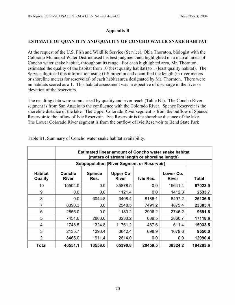
Biological Opinion, USACE/CRMWD (2-15-F-2004-0242) December 3, 2004
70
Appendix B
ESTIMATE OF QUANTITY AND QUALITY OF CONCHO WATER SNAKE HABITAT At the request of the U.S. Fish and Wildlife Service (Service), Okla Thornton, biologist with the Colorado Municipal Water District used his best judgment and highlighted on a map all areas of Concho water snake habitat, throughout its range. For each highlighted area, Mr. Thornton, estimated the quality of the habitat from 10 (best quality habitat) to 1 (least quality habitat). The Service digitized this information using GIS program and quantified the length (in river meters or shoreline meters for reservoirs) of each habitat area designated by Mr. Thornton. There were no habitats scored as a 1. This habitat assessment was irrespective of discharge in the river or elevation of the reservoirs. The resulting data were summarized by quality and river reach (Table B1). The Concho River segment is from San Angelo to the confluence with the Colorado River. Spence Reservoir is the shoreline distance of the lake. The Upper Colorado River segment is from the outflow of Spence Reservoir to the inflow of Ivie Reservoir. Ivie Reservoir is the shoreline distance of the lake. The Lower Colorado River segment is from the outflow of Ivie Reservoir to Bend State Park Table B1. Summary of Concho water snake habitat availability.
Estimated linear amount of Concho water snake habitat
(meters of stream length or shoreline length) Subpopulation (River Segment or Reservoir)
Habitat Quality
Concho River
Spence Res.
Upper Co River Ivie Res.
Lower Co. River Total
10 15504.0 0.0 35878.5 0.0 15641.4 67023.99 0.0 0.0 1121.4 0.0 1412.3 2533.78 0.0 6044.8 3408.4 8186.1 8497.2 26136.57 8390.3 0.0 2548.5 7491.2 4875.4 23305.46 2856.0 0.0 1183.2 2906.2 2746.2 9691.65 7451.6 2883.6 3233.2 689.5 2860.7 17118.64 1748.5 1324.8 11761.2 487.6 611.4 15933.53 2135.7 1393.4 3642.4 698.9 1679.6 9550.02 8465.0 1911.4 2614.0 0.0 0.0 12990.4
Total 46551.1 13558.0 65390.8 20459.5 38324.2 184283.6

Biological Opinion, USACE/CRMWD (2-15-F-2004-0242) December 3, 2004
71
The results were then grouped into high (scores 8-10), medium (scores 5-7), and low (scores 2-4) to compare the amount of habitat quality in each river segment or reservoir. Overall, the Upper Colorado River segment had the most habitat and the most high quality habitats, and Spence Reservoir had the least overall habitat available (Figure B1).
Estimate of amount of CWS habitatby reach and quality
010203040506070
Conch
o Rive
r
Spenc
e Res
.
Upper
Co Rive
r
Ivie R
es.
Lower
Co. Rive
r
(Tho
usan
ds)
River Reach (subpopulation)
Line
ar M
eter
s
Low (2-4)Medium (5-7)High (8-10)
Figure B1. Comparison of Concho water snake habitat available by river segment or reservoir and by quality of habitat. As a percent of total Concho water snake habitat available, the river segments contain 82 percent of all habitats and the two reservoirs contain 18 percent of all habitats, based on this analysis (Figure B2). The largest percent of high quality habitat was found in the Upper and Lower Colorado River segments (42 percent and 27 percent, respectively) and the reservoirs combined contain 15 percent of available high quality habitats.

Biological Opinion, USACE/CRMWD (2-15-F-2004-0242) December 3, 2004
72
Figure B2. Percent of available Concho water snake habitat by quality and river reach.
HIGH quality CWS habitat?
Spence Res.6%
Ivie Res.9%
Upper Co River42%
Concho River16%
Lower Co. River27%
MEDIUM quality CWS habitat?
Concho River37%
Spence Res.6%
Upper Co River14%
Ivie Res.22%
Lower Co. River21%
LOW quality CWS habitat?
Spence Res.12%
Upper Co River47%
Lower Co. River6%
Ivie Res.3%
Concho River32%
ALL quality CWS habitat?
Lower Co. River21%
Ivie Res.11%
Upper Co River36%
Spence Res.7%
Concho River25%

Biological Opinion, USACE/CRMWD (2-15-F-2004-0242) December 3, 2004
73
Appendix C
MINIMUM FLOW SIMULATIONS OF COLORADO RIVER FLOWS ABOVE AND BELOW SPENCE RESERVOIR BASED ON 1999 - 2004 FLOW CONDITIONS
I. Analysis Objective
Predict the downstream flows in the Colorado River at Ballinger of proposed reservoir releases from Spence Reservoir, based on District proposed operations and using the actual flow conditions from January 1, 1999, to August 15, 2004. II. Current Operational Requirement 1986 Biological Opinion and 1987 MOA requires continuous daily flow of 10 cfs at the Ballinger gage. III. Proposed Spence Reservoir Operations District has proposed that Spence ouflows be 4.0 cfs in summer (Apr - Sept) and 1.5 cfs in winter (Oct - Mar), when inflows (as measured at Silver gage) are at least this level. No flows will be released if inflows are not equal to or greater than the minimum proposed. IV. Definitions of Abbreviations
Sm = USGS measured flow, Colorado River above Silver gage, inflow to Spence Reservoir RLm = USGS measured flow, Colorado River near Robert Lee gage, outflow from Spence Reservoir Bm = USGS measured flow, Colorado River at Ballinger gage, downstream flows Sp = Predicted flow at Silver gage based on District proposed flows
RLp = Predicted flow at Silver gage based on District proposed flows Bp = Predicted flow at Silver gage based on District proposed flows
WINTER = October 1 to March 31
SUMMER = April 1 to September 30 V. Rules for simulating flows
1. If the measured Silver inflow is less than 1.5 cfs in winter or 4.0 cfs in summer, then the predicted Robert Lee outflow = 0 cfs.
WINTER: If Sm < 1.5 cfs, then RLp = 0 cfs.
SUMMER: If Sm < 4.0 cfs, then RLp = 0 cfs. 2. If the measured Silver inflow is equal to or greater than 1.5 cfs in winter or 4.0 cfs in summer, then the predicted Robert Lee outflow = 1.5 cfs in summer and 4.0 cfs in winter.
WINTER: If Sm => 1.5 cfs, then RLp = 1.5 cfs.
SUMMER: If Sm => 4.0 cfs, then RLp = 4.0 cfs. 3. If the measured Ballinger discharge is greater than measured Robert Lee discharge, then the predicted Ballinger discharge is the measured Ballinger discharge less the measured Robert Lee discharge plus the predicted Robert Lee outflow.
If Bm > RLm, then Bp = (Bm - RLm) + RLp

Biological Opinion, USACE/CRMWD (2-15-F-2004-0242) December 3, 2004
74
4. If the measured Ballinger discharge is less than the measured Robert Lee discharge, and the difference in the measured discharge at Robert Lee and the measured discharge at Ballinger is less than 1.5 cfs in winter (4.0 cfs in summer), then the predicted Ballinger discharge is the predicted discharge at Robert Lee less the difference in Robert Lee and Ballinger measured discharges.
WINTER: If Bm < RLm, and RLm - Bm < 1.5 cfs, then Bp = RLp - (RLm - Bm)
SUMMER: If Bm < RLm, and RLm - Bm < 4.0 cfs, then Bp = RLp - (RLm - Bm) 5. If the measured Ballinger discharge is less than the measured Robert Lee discharge, and the difference in the flow measured at Robert Lee and the measured discharge at Ballinger is greater than 1.5 cfs in winter (4.0 cfs in summer), then the predicted Ballinger flow is 0.
WINTER: If Bm < RLm, and RLm - Bm > 1.5 cfs, then Bp = 0 cfs
SUMMER: If Bm < RLm, and RLm - Bm > 4.0 cfs, then Bp = 0 cfs
6. The resulting spreadsheet formulas are in Table 1.
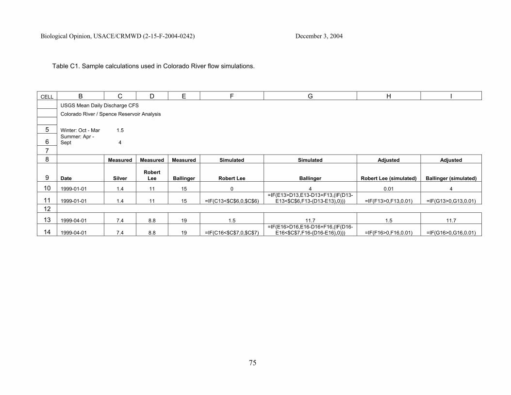
Biological Opinion, USACE/CRMWD (2-15-F-2004-0242) December 3, 2004
75
Table C1. Sample calculations used in Colorado River flow simulations.
CELL B C D E F G H I USGS Mean Daily Discharge CFS Colorado River / Spence Reservoir Analysis 5 Winter: Oct - Mar 1.5
6 Summer: Apr - Sept 4
7 8 Measured Measured Measured Simulated Simulated Adjusted Adjusted
9 Date Silver Robert
Lee Ballinger Robert Lee Ballinger Robert Lee (simulated) Ballinger (simulated)
10 1999-01-01 1.4 11 15 0 4 0.01 4
11 1999-01-01 1.4 11 15 =IF(C13<$C$6,0,$C$6) =IF(E13>D13,E13-D13+F13,(IF(D13-
E13<$C$6,F13-(D13-E13),0))) =IF(F13>0,F13,0.01) =IF(G13>0,G13,0.01) 12
13 1999-04-01 7.4 8.8 19 1.5 11.7 1.5 11.7
14 1999-04-01 7.4 8.8 19 =IF(C16<$C$7,0,$C$7) =IF(E16>D16,E16-D16+F16,(IF(D16-
E16<$C$7,F16-(D16-E16),0))) =IF(F16>0,F16,0.01) =IF(G16>0,G16,0.01)

Biological Opinion, USACE/CRMWD (2-15-F-2004-0242) December 3, 2004
76
VI. Results % frequency of days, CR at Ballinger
Actual (1999-2004) Simulated Flows
Total Days, < 10 cfs 57.5% 89.0% Total Days, = 0 cfs 0.0% 50.0%
Winter, = 0 cfs 0.0% 36.3%
Summer, = 0 cfs 0.0% 62.3%
Winter, =< 1.5 cfs 5.4% 51.0% Summer, =< 1.5 cfs 17.3% 67.2%
Winter, < 10 cfs 49.4% 92.1%
Summer, < 10 cfs 64.5% 85.3%
Total Days, N = 2054 2054 Winter Days, n = 1002 1002
Summer Days, n = 1052 1052
All, Mean Annual Flow 24.8 17.2 All, Median Annual Flow 8.6 0.8
% frequency of days, CR at Robert Lee
All, = 0 cfs 0 50.1% All, =< 1.5 cfs 4.2% 29.1% All, =< 4.0 cfs 6.1% 20.7% = 4 cfs All, =< 10 cfs 53.9% 100.0%
All, >10 cfs 46.1% 0.0% VII. Notes
1. The time period under analysis, January 1, 1999 to August 15, 2004, is a very dry period for overall river flows.
2. Discharge records from October 1, 2003, to August 15, 2004, are preliminary and not final by USGS.
3. All discharges = 0, or predicted negative numbers, were converted to 0.01 for logarithmic graph plots.