united states department of the interior · exploration and development activity in the hiline ......
TRANSCRIPT

1600/3100
MTM040
July 24, 2013
Dear Reader,
The Bureau of Land Management (BLM) HiLine District Office has prepared an environmental
assessment (EA) to analyze the potential effects from offering and issuing 4 nominated lease
parcels of federal minerals for competitive oil and gas leasing in a sale tentatively scheduled to
occur on October 22, 2013. The EA was available for a 30-day public comment period.
Based on our analysis and review of comments received, the EA has been updated (refer to
Chapter 5 of the EA for a summary of public comments). A competitive oil and gas lease sale is
tentatively scheduled to be held on October 22, 2013. It will be my recommendation to offer the
4 lease parcels in whole, 880.15 surveyed federal mineral acres, along with stipulations identified
in the BLM preferred alternative in the updated EA, see Appendix A.
We anticipate preparing and finalizing our Decision Record after the October oil and gas lease
sale, but prior to lease issuance. Upon finalization, the Decision Record and accompanying
finding of no significant impact (FONSI) will be posted on the website listed below.
Please refer to the Montana/Dakotas BLM website at http://blm.gov/h2kd. Current and updated
information about our EAs, Lease Sale Notices, and corresponding information pertaining to this
sale can be found at the link referenced above. Once there, locate the October 22, 2013 lease
sale to review the MCFO EA and the parcel list with recommended stipulations.
If you have any questions, or would like more information about the issuance of the updated EA,
Decision Record and FONSI, please contact us at 406-791-7700.
Sincerely,
Mark K. Albers
District Manager
In Reply Refer To:
United States Department of the Interior
BUREAU OF LAND MANAGEMENT
HiLine District Office
www.blm.gov/mt

United States Department of the Interior
Bureau of Land Management
Environmental Assessment DOI-BLM-MTM020-2013-0008-EA
July 24, 2013
Project Title: Oil and Gas Lease Parcel Sale,
October 22, 2013
Location: HiLine District, specifically in the Glasgow Field Office
(See attached Appendix A for list of lease parcels by number and legal description
and Maps)
U.S. Department of the Interior
Bureau of land management
Great Falls Oil and Gas Field Office
1101 15th Street North
Great Falls, MT 59401
Phone: 406-791-7700
FAX: 406-731-5303

Glasgow Field Office Oil and Gas Lease Sale EA
DOI-BLM-MTM020-2013-0008-EA
CONTENTS
1.0 PURPOSE AND NEED ...................................................................................................................... 1
1.1 Introduction ................................................................................................................................ 1
1.2 Purpose and Need for the Proposed Action ............................................................................... 2
1.3 Conformance with Land Use Plan(s) ......................................................................................... 2
1.4 Public Scoping and Identification of Issues ............................................................................... 3
2.0 DESCRIPTION OF ALTERNATIVES, INCLUDING PROPOSED ACTION ................................ 4
2.1 Alternative A - No Action .......................................................................................................... 4
2.2 Alternative B – Proposed Action ............................................................................................... 4
2.3 Alternatives Considered, but Eliminated from further Analysis ................................................ 5
3.0 AFFECTED ENVIRONMENT .......................................................................................................... 7
3.1 Introduction ................................................................................................................................ 7
3.2 Air Resources ........................................................................................................................... 11
3.3 Soil Resources .......................................................................................................................... 18
3.4 Water Resources ...................................................................................................................... 19
3.5 Vegetation Resources ............................................................................................................... 21
3.6 Special Status Species .............................................................................................................. 24
3.7 Fish and Wildlife...................................................................................................................... 25
3.8 Cultural Resources .................................................................................................................. 26
3.9 Native American Religious Concerns ...................................................................................... 26
3.10 Paleontology ......................................................................................................................... 27
3.11 Visual Resources .................................................................................................................... 27
3.12 Forest and Woodland Resources ........................................................................................... 29
3.13 Livestock Grazing .................................................................................................................. 29
3.14 Recreation and Travel Management ...................................................................................... 29
3.15 Lands and Realty.................................................................................................................... 30
3.16 Minerals ................................................................................................................................. 30
3.17 Special Designations .............................................................................................................. 32
3.18 Social and Economic Conditions ........................................................................................... 32
4.0 ENVIRONMENTAL IMPACTS ...................................................................................................... 36
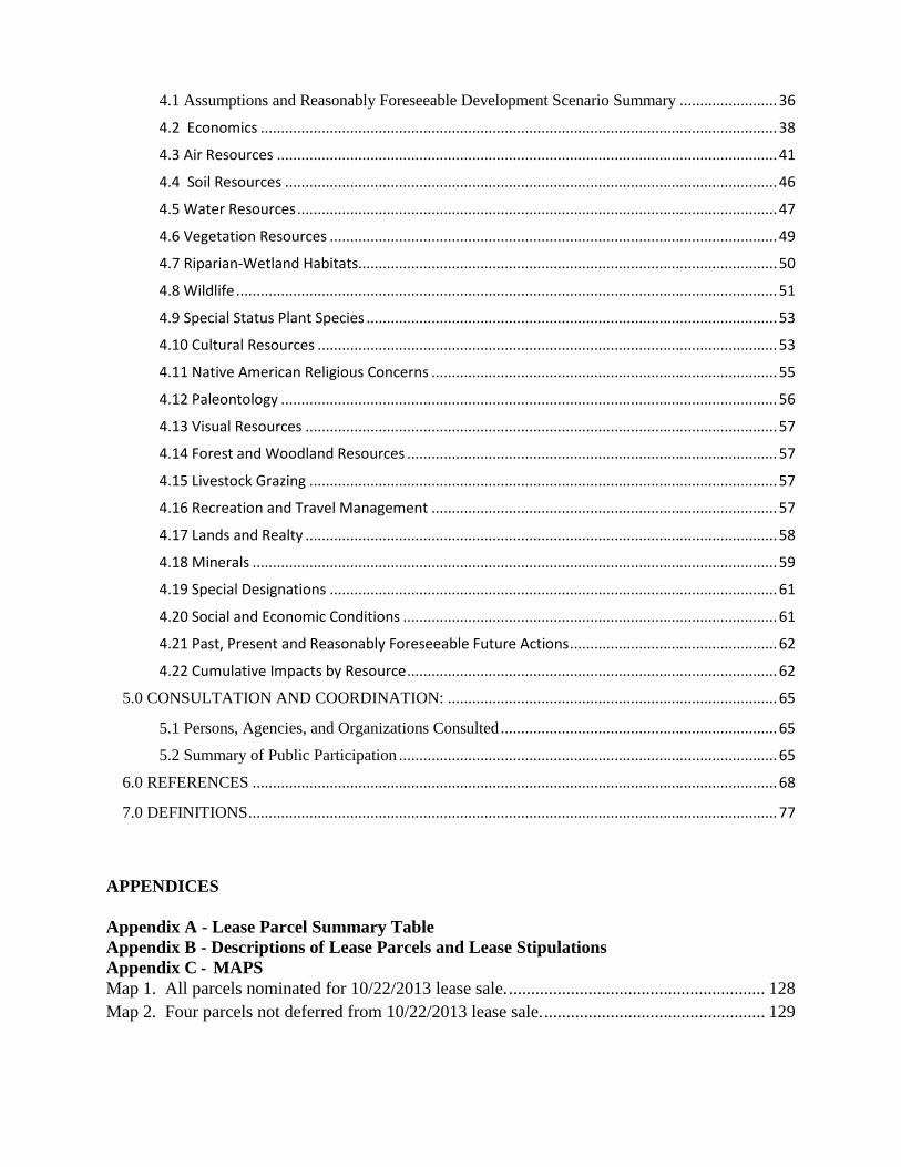
4.1 Assumptions and Reasonably Foreseeable Development Scenario Summary ........................ 36
4.2 Economics ............................................................................................................................... 38
4.3 Air Resources ........................................................................................................................... 41
4.4 Soil Resources ......................................................................................................................... 46
4.5 Water Resources ...................................................................................................................... 47
4.6 Vegetation Resources .............................................................................................................. 49
4.7 Riparian-Wetland Habitats....................................................................................................... 50
4.8 Wildlife ..................................................................................................................................... 51
4.9 Special Status Plant Species ..................................................................................................... 53
4.10 Cultural Resources ................................................................................................................. 53
4.11 Native American Religious Concerns ..................................................................................... 55
4.12 Paleontology .......................................................................................................................... 56
4.13 Visual Resources .................................................................................................................... 57
4.14 Forest and Woodland Resources ........................................................................................... 57
4.15 Livestock Grazing ................................................................................................................... 57
4.16 Recreation and Travel Management ..................................................................................... 57
4.17 Lands and Realty .................................................................................................................... 58
4.18 Minerals ................................................................................................................................. 59
4.19 Special Designations .............................................................................................................. 61
4.20 Social and Economic Conditions ............................................................................................ 61
4.21 Past, Present and Reasonably Foreseeable Future Actions ................................................... 62
4.22 Cumulative Impacts by Resource ........................................................................................... 62
5.0 CONSULTATION AND COORDINATION: ................................................................................. 65
5.1 Persons, Agencies, and Organizations Consulted .................................................................... 65
5.2 Summary of Public Participation ............................................................................................. 65
6.0 REFERENCES ................................................................................................................................. 68
7.0 DEFINITIONS .................................................................................................................................. 77
APPENDICES
Appendix A - Lease Parcel Summary Table
Appendix B - Descriptions of Lease Parcels and Lease Stipulations
Appendix C - MAPS
Map 1. All parcels nominated for 10/22/2013 lease sale. .......................................................... 128
Map 2. Four parcels not deferred from 10/22/2013 lease sale. .................................................. 129
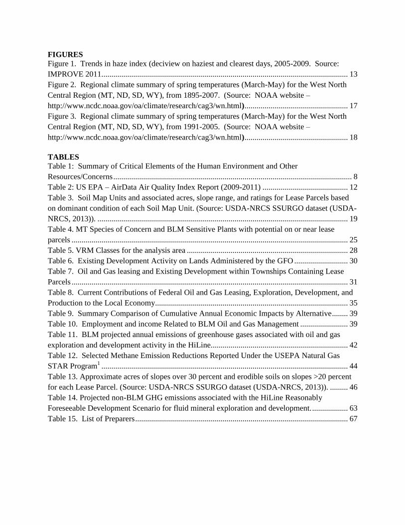
FIGURES
Figure 1. Trends in haze index (deciview on haziest and clearest days, 2005-2009. Source:
IMPROVE 2011............................................................................................................................ 13
Figure 2. Regional climate summary of spring temperatures (March-May) for the West North
Central Region (MT, ND, SD, WY), from 1895-2007. (Source: NOAA website –
http://www.ncdc.noaa.gov/oa/climate/research/cag3/wn.html) .................................................... 17
Figure 3. Regional climate summary of spring temperatures (March-May) for the West North
Central Region (MT, ND, SD, WY), from 1991-2005. (Source: NOAA website –
http://www.ncdc.noaa.gov/oa/climate/research/cag3/wn.html) .................................................... 18
TABLES
Table 1: Summary of Critical Elements of the Human Environment and Other
Resources/Concerns ........................................................................................................................ 8
Table 2: US EPA – AirData Air Quality Index Report (2009-2011) ........................................... 12
Table 3. Soil Map Units and associated acres, slope range, and ratings for Lease Parcels based
on dominant condition of each Soil Map Unit. (Source: USDA-NRCS SSURGO dataset (USDA-
NRCS, 2013)). .............................................................................................................................. 19
Table 4. MT Species of Concern and BLM Sensitive Plants with potential on or near lease
parcels ........................................................................................................................................... 25
Table 5. VRM Classes for the analysis area ................................................................................. 28
Table 6. Existing Development Activity on Lands Administered by the GFO ........................... 30
Table 7. Oil and Gas leasing and Existing Development within Townships Containing Lease
Parcels ........................................................................................................................................... 31
Table 8. Current Contributions of Federal Oil and Gas Leasing, Exploration, Development, and
Production to the Local Economy................................................................................................. 35
Table 9. Summary Comparison of Cumulative Annual Economic Impacts by Alternative ........ 39
Table 10. Employment and income Related to BLM Oil and Gas Management ........................ 39
Table 11. BLM projected annual emissions of greenhouse gases associated with oil and gas
exploration and development activity in the HiLine. .................................................................... 42
Table 12. Selected Methane Emission Reductions Reported Under the USEPA Natural Gas
STAR Program1 ............................................................................................................................ 44
Table 13. Approximate acres of slopes over 30 percent and erodible soils on slopes >20 percent
for each Lease Parcel. (Source: USDA-NRCS SSURGO dataset (USDA-NRCS, 2013)). ......... 46
Table 14. Projected non-BLM GHG emissions associated with the HiLine Reasonably
Foreseeable Development Scenario for fluid mineral exploration and development. .................. 63
Table 15. List of Preparers ........................................................................................................... 67

1
Glasgow Field Office Oil and Gas Lease Sale EA
DOI-BLM-MTM020-2013-0008-EA
1.0 PURPOSE AND NEED
1.1 Introduction
It is the policy of the Bureau of Land Management (BLM) to make mineral resources available
for use and to encourage development of mineral resources to meet national, regional, and local
needs. This policy is based on various laws, including the Mineral Leasing Act of 1920 and the
Federal Land Policy and Management Act of 1976. The Federal Onshore Oil and Gas Leasing
Reform Act of 1987 Sec. 5102(a)(b)(1)(A) directs the BLM to conduct quarterly oil and gas
lease sales in each state whenever eligible lands are available for leasing. The Montana State
Office conducts mineral estate lease auctions for lands managed by the federal government,
whether the surface is managed by the Department of the Interior (BLM or Bureau of
Reclamation), United States Forest Service, or other departments and agencies. In some cases
the BLM holds subsurface mineral rights on split estate lands where the surface estate is owned
by another party, other than the federal government. Federal mineral leases can be sold on such
lands as well. The Montana State Office has historically conducted five lease sales per year.
Members of the public file Expressions of Interest (EOI) to nominate parcels for leasing by the
BLM. From these EOIs, the Montana State Office provides draft parcel lists to the appropriate
field offices for review. BLM field offices then review legal descriptions of nominated parcels
to determine: if they are in areas open to leasing; if new information has come to light which
might change previous analyses conducted during the land use planning process; if there are
special resource conditions of which potential bidders should be made aware; and which
stipulations should be identified and included as part of a lease. Ultimately, all of the lands in
proposed lease sales are nominated by private individuals, companies, or the BLM, and therefore
represent areas of high interest.
This environmental assessment (EA) has been prepared to disclose and analyze the potential
environmental consequences from leasing all 257 nominated lease parcels located in the
Glasgow Field Office (GFO), to be included as part of a competitive oil and gas lease sale
tentatively scheduled to occur in October 2013. Of the 257 nominations, 251 are located within,
or immediately adjacent to, priority Greater Sage-Grouse (Candidate Species) habitat. Of the
nominated parcels, 2 are located in primary habitat for Sprague’s pipit. The analysis area
includes 257 nominated parcels in Valley County (See Map 1 located in Appendix C for
location). Refer to Section 2.3 – Alternatives Considered but Dismissed from Further Analysis
for additional information and rationale as to why 253 parcels are not considered in detail.
2
1.2 Purpose and Need for the Proposed Action
The purpose of offering parcels for competitive oil and gas leasing is to provide opportunities for
private individuals or companies to explore for and develop federal oil and gas resources after
receipt of necessary approvals and to sell the oil and gas in public markets.
This action is needed to help meet the energy needs of the people of the United States. By
conducting lease sales, the BLM provides for the potential increase of energy reserves for the
U.S., a steady source of income, and at the same time meets the requirement identified in the
Energy Policy Act, Sec. 362(2), Federal Oil and Gas Leasing Reform Act of 1987, and the
Mineral Leasing Act of 1920, Sec. 17.
The decision to be made is whether to sell and issue oil and gas leases on the lease parcels
identified, and, if so, identify stipulations that would be included with specific lease parcels at
the time of lease sale.
1.3 Conformance with Land Use Plan(s)
This EA is tiered to and conforms to the information and analysis contained in the Judith-Valley-
Phillips Resource Management Plan (JVP RMP). Although the JVP RMP was approved in 1994
to guide management of all resources within the Glasgow Field Office, it did not make any
specific decisions relative to the leasing of fluid minerals due to a protest on the 1992 Final
RMO. Since that time, the Glasgow Field Office has, and will continue, to defer leasing of
nominated parcels that would require special stipulations to protect important wildlife values
until a new RMP is completed. The leasing of nominated parcels not requiring special wildlife
stipulations has continued in the Glasgow Field Office through reliance on the leasing decisions
made in previous land use plans and programmatic analyses. This EA is tiered to and conforms
to the information and analysis contained in the Valley County management Framework Plans
(MFP) (1977) and the Oil & Gas Environmental Assessment of the BLM Leasing Program –
Lewistown District (September 1981).
The parcels to be offered are within areas open to oil and gas leasing. Analysis of the four
parcels is documented in this EA, and was conducted by Glasgow Field Office, HiLine District,
and Montana State Office resource specialists who relied on professional knowledge of the areas
involved, review of current databases and file information, and site visits to ensure that
appropriate stipulations were recommended for a specific parcel. Analysis may have also
identified the need to defer entire or partial parcels from leasing pending further environmental
review in the HiLine District RMP that is currently being written.
At the time of this review it is unknown whether a particular parcel will be sold and a lease
issued. It is unknown when, where, or if future well sites, roads, and facilities might be
proposed. Assessment of potential activities and impacts was based on potential well densities
discerned from the Reasonably Foreseeable Development (RFD) Scenario developed for the
HiLine District. Detailed site-specific analysis and mitigation of activities associated with any
particular lease would occur when a lease holder submits an application for permit to drill
(APD). A more complete description of mitigation, BMPs, and conditions of approval related to
oil and gas lease activities can be found in the Surface Operating Standards and Guidelines for

3
Oil and Gas Exploration and Development-The Gold Book, and online at
http://www.blm.gov/wo/st/en/prog/energy/oil_and_gas/best_management_practices. html.
Offering the parcels for sale and issuing leases would not be in conflict with any local, county, or
state laws or plans.
BLM Instruction Memorandum (IM) No. 2012-043 of 27 December 2011 titled “Greater Sage-
Grouse Interim Management Policies and Procedures” was also consulted. Many of the parcels
are in Preliminary Priority habitat (PPH) with less parcels being in adjacent Preliminary General
Habitat (PGH) areas. That IM said for Fluid Mineral Leasing that “Field Offices retain the
discretion to not move forward with a nomination or defer making a final decision on a leasing
decision until the completion of the LUP process described in the National Greater Sage-Grouse
Planning Strategy for the affected area.” Nominations in PGH could also be deferred if
authorizations could result in Greater Sage-Grouse population loss in adjoining PPH. That
guidance was followed for large areas of PPH and PGH occupied by Greater Sage-Grouse in the
Glasgow Field Office.
1.4 Public Scoping and Identification of Issues
Public scoping for this project was conducted through a 15-day scoping period advertised on the
BLM Montana State Office website and posted on the Glasgow Field Office website National
Environmental Policy Act (NEPA) notification log. Scoping was initiated March 22, 2013.
Several scoping comments pertained to general concerns related to mineral ownership and split
estate questions, while other scoping comments were specific to resource concerns. Refer to
Chapter 5 of this EA for a more complete summary of the scoping comments received.
The BLM coordinates with Montana Fish, Wildlife and Parks (MFWP), and the United States
Fish and Wildlife Service (USFWS) to manage wildlife habitat because BLM management
decisions can affect wildlife populations which depend on the habitat. The BLM manages
habitat on BLM lands, while MFWP is responsible for managing wildlife species populations.
The USFWS also manages some wildlife populations but only those federal trust species
managed under mandates such as the Endangered Species Act, Migratory Bird Treaty Act, and
the Bald and Golden Eagle Protection Act. Managing wildlife is factored into project planning at
multiple scales and is to be implemented early in the planning process.
Coordination with BOR, COE, MFWP and USFWS was conducted for 4 parcels being reviewed.
BLM has coordinated with MFWP and USFWS in the completion of this EA in order to prepare
analysis, identify protective measures, and apply stipulations associated with these parcels being
analyzed.
The BLM consults with Native Americans under Section 106 of the National Historic
Preservation Act. BLM sent letters to Tribal Presidents and THPO’s of the Blackfeet, Gros
Ventre, Assiniboine, Sioux, Flathead (Salish) Kootenai, Shoshone, Bannock, Northern
Cheyenne, Little Shell Tribe of Chippewa, Nez Perce, Crow, and Cree Tribes on April 4, 2013
informing them of the potential for the 4 parcels to be leased and inviting them to submit issues
and concerns BLM should consider in the environmental analysis. No specific issues were
identified with the 4 parcels to be leased.

4
BLM will send a second letter to the tribes informing them about the 30 day public comment
period for the EA and solicit any information BLM should consider before making a decision.
2.0 DESCRIPTION OF ALTERNATIVES, INCLUDING PROPOSED ACTION
2.1 Alternative A - No Action
For EAs on externally initiated Proposed Actions, the No Action Alternative generally means
that the Proposed Action would not take place. In the case of a lease sale, this would mean that
all expressions of interest to lease (parcel nominations) would be denied or rejected.
The No Action Alternative would exclude all 257 parcels within the Glasgow Field Office from
the lease sale. Surface management would remain the same and ongoing oil and gas
development would continue on surrounding federal, private, and state leases.
2.2 Alternative B – Proposed Action
The Proposed Action Alternative would be to offer four parcels of federal minerals for oil and
gas leasing, covering 880.15 acres administered by the Glasgow Field Office, in conformance
with the existing land use planning decisions. The parcels are located in Valley County,
Montana. Parcel number, size, and detailed locations and associated stipulations are listed in
Appendix A. Map 1 indicates the detailed location of each parcel.
The four parcels being offered for lease are:
MTM 102757-6L 320 ac Valley County
MTM 102757-6N 160 ac Valley County
MTM 102757-6P 320 ac Valley County 50% federal mineral interest
MTM 102757-6J 80.15 ac Valley County
Since all offered parcels are split estate (private surface), the BLM provided courtesy notification
to private landowners that their lands are considered in this NEPA analysis and would be
considered for inclusion in an upcoming lease sale. If any activity were to occur on such split
estate parcels, the lessee and/or operator would be responsible for adhering to BLM requirements
as well as reaching an agreement with the private surface landowners regarding access, surface
disturbance and reclamation. Standard lease terms, stipulations, conditions, and operating
procedures would apply to these parcels.
Standard operating procedures, best management practices and required conditions of approval
and the application of lease stipulations change over time to meet overall RMP objectives. In
some cases new lease stipulations may need to be developed and these types of changes may
require an RMP amendment. There is no relief from meeting RMP objectives if local conditions
were to become drier and hotter during the life of the RMP. In this situation, management
practices might need to be modified to continue meeting overall RMP management objectives.
An example of a climate related modification is the imposition of additional conditions of
approval to reduce surface disturbance and implement more aggressive dust treatment measures.

5
Both actions reduce fugitive dust, which would otherwise be exacerbated by the increasingly arid
conditions that could be associated with climate change.
Oil and gas leases would be issued for a 10-year period and would continue for as long thereafter
as oil or gas is produced in paying quantities. If a lessee fails to produce oil and gas, does not
make annual rental payments, does not comply with the terms and conditions of the lease, or
relinquishes the lease, ownership of the minerals leased would revert back to the federal
government, and the lease could be resold.
Drilling of wells on a lease would not be permitted until the lease owner or operator secures
approval of a drilling permit and a surface use plan specified at 43 CFR 3162.
2.3 Alternatives Considered, but Eliminated from further Analysis
An alternative that included leasing all 253 deferred nominations that are located within or
immediately adjacent to the State of Montana Sage-Grouse core areas was considered. There are
several issues surrounding this potential alternative that complicate leasing (or offering to lease)
these parcels at this time. Four key factors, as described below, were considered to reach this
conclusion: 1) Quality of the affected habitat, 2) Recent research, funded in part by this Agency,
3) Ongoing conservation efforts by other Federal Agencies, and 4) Impending release of an
updated Resource Management Plan with specific measures to address all of the above. These
253 nominations will be reconsidered once the HiLine RMP is complete. The total acreage of
deferred parcels is 103,652.62 acres.
The Glasgow Field Office contains important breeding and nesting range of the Candidate
Sprague’s pipit. Important habitat for the Sprague’s pipit was a primary consideration in the
deferral of 2 parcels. Two hundred and fifty-three parcels were deferred because of the presence
of high value habitat for both the Sprague’s pipit and the Greater Sage-Grouse. These include
some parcels with less than optimum Sprague’s pipit habitat. The parcels that are being carried
forward for analysis in the Proposed Action contain almost no Sprague’s pipit habitat at present
because of cultivation and the introduction of non-native grass cover. The Sprague’s Pipit Lease
Notice (14-15) would be attached to the leases however, in case the vegetation reverts to native
grass cover prior to any development during the terms of the leases.
1) Quality of the Affected Habitat
The 253 parcels are within, or immediately adjacent to, two Greater Sage - Grouse Core Areas as
designated by the State of Montana’s Fish, Wildlife and Parks. As defined by the State of
Montana Sage-Grouse Core Areas are:
Definition: Sage-grouse core areas are habitats associated with 1) Montana’s highest densities of
sage-grouse (25% quartile), based on male counts and/or 2) sage-grouse lek complexes and
associated habitat important to sage-grouse distribution.
These Core Areas are also considered Preliminary Priority Habitat (PPH) as defined in BLM
Instruction Memorandum (IM) No. 2012-043 “Greater Sage-Grouse Interim Management
Policies and Procedures.” Most of the areas adjacent to PPH are considered Preliminary General
Habitat (PGH), also defined in IM No. 2012-043. Most of the land area in the Glasgow Field

6
Offices is either PPH or PGH except for the Little Rocky Mountains, timbered portions of the
Missouri River Breaks, and agricultural areas along the Milk River.
As such, these areas represent some of the most important habitat areas for future conservation of
Greater Sage-Grouse within the State of Montana.
2) Recent Research
Oil and gas development may, or may not be compatible with Sage-Grouse habitat depending
upon the type and level of development proposed and the specific characteristics of the habitat to
be affected. It has been shown that oil and gas development has negatively impacted sage-grouse
in the past. Based on recent research, the current oil and gas stipulations for sage-grouse are
considered ineffective to ensure that sage-grouse can persist within fully developed areas. With
regard to existing restrictive stipulations applied by the BLM, (Walker et al. 2007a) research has
demonstrated that the 0.4-km (0.25 miles) NSO lease stipulation is insufficient to conserve
breeding sage-grouse populations in fully developed gas fields because this buffer distance
leaves 98 percent of the landscape within 3.2 km (2 miles) open to full-scale development. Full-
field development of 98 percent of the landscape within 3.2 km (2 miles) of leks in a typical
landscape in the Powder River Basin reduced the average probability of lek persistence from 87
percent to 5 percent (Walker et al. 2007a).
Other studies also have assessed the efficacy of existing BLM stipulations for sage-grouse.
Impacts to leks from energy development are most severe near the lek, and remained discernible
out to distances more than 6 km (3.6 miles) (Holloran 2005, Walker et al. 2007a), and have
resulted in the extirpation of leks within gas fields (Holloran 2005, Walker et al. 2007a).
Holloran (2005) shows that lek counts decreased with distance to the nearest active drilling rig,
producing well, or main haul road, and that development influences counts of displaying males
to a distance of between 4.7 and 6.2 km (2.9 and 3.9 miles). All well-supported models in
Walker et al. (2007a) indicate a strong effect of energy development, estimated as proportion of
development within either 0.8 km (0.5 miles) or 3.2 km (2 miles), on lek persistence. Buffer
sizes of 0.25 mi., 0.5 mi., 0.6 mi. and 1.0 mi. result in an estimated lek persistence of 5 percent,
11 percent, 14 percent, and 30 percent. Lek persistence in the absence of oil and gas field
development averages approximately 85 percent. Models with development at 6.4 km (4 miles)
had considerably less support, but the regression coefficient indicated that impacts were still
apparent out to 6.4 km (4 miles) (Walker et al. 2007a). Tack (2010) found impacts of energy
development on lek abundances (numbers of males per lek) out to 7.6 miles.
The previously used 2 mile timing stipulation only applies between March 1 to June 15, and
development can occur within the 2 miles of the lek outside of those dates. Not all lease parcels
would be expected to see full field development as noted in the range of RFD, although effects
would most likely mirror these studies to some degree proportionate to the amount of
development that occurs outside of the stipulated timeframe.
Noise has been shown to affect sage-grouse and associated sagebrush obligates. Sage-grouse are
known to select highly visible leks with good acoustic properties. Effects to sage-grouse would
be a decrease in numbers of males on leks and activity levels and lower nest initiation near oil
and gas development. Sage-grouse numbers on leks within 1.6 km (1 mile) of coal bed natural
7
gas compressor stations in Campbell County, Wyoming were shown to be consistently lower
than on leks not affected by this disturbance (Braun et al. 2002). Holloran (2005), Holloran et. al
(2005a, 2005b), Holloran and Anderson (2005) reported that lek activity by sage-grouse
decreased downwind of drilling activities, suggesting that noise had measurable “negative”
impacts on sage-grouse. The actual level of noise (measured in decibels) that would not affect
Greater Sage-Grouse breeding and nesting activities is presently unknown.
3) Ongoing conservation efforts by other Agencies
The Natural Resources Conservation Service (NRCS) has recently undertaken a large
cooperative project within the State of Montana to provide assistance to agricultural producers to
initiate conservation practices beneficial to Greater Sage-Grouse. Core Area 4 (Golden Valley
County), was selected as the pilot Core Area for this effort. To date (fiscal years 2010 and 2011)
the NRCS has invested $3,623,000 to support Sage- Grouse conservation, to protect 128,000
acres. Also in fiscal year 2011, the NRCS has invested, or is planning to invest another
$1,606,000 to protect 52,000 acres in Core Area 3 (Petroleum County) and Core Area 4
(Musselshell County). Additional work has now been completed through the Glasgow Working
Group in Phillips and Valley Counties. Effectiveness monitoring of the conservation practices is
an integral part of the NRCS program. Leasing and subsequent oil and gas development at this
time could jeopardize the substantial investment that the federal government has made, and at the
least, would cloud any results of the effectiveness monitoring.
4) HiLine Resource Management Plan
The HiLine District composed of Havre, Malta and Glasgow Field Offices, in addition to the
Great Falls Oil and Gas Field Office is in the process of completing a Resource Management
Plan. The process began in 2008, and the draft RMP has since been released for public review.
Since 2008 there have been substantial improvements in oil and gas development technology, as
well as our understanding of Sage-Grouse life history requirements and development related
disturbance impacts (see item 2 above). The updated RMP (in progress) will provide stipulations
relative to oil and gas development and Sage Grouse habitat based upon our current
understanding, including those areas where no development may be the appropriate management
response.
Based on these considerations and careful review, the 253 parcels would be eliminated from
detailed study in this analysis and deferred to a later date.
3.0 AFFECTED ENVIRONMENT
3.1 Introduction
This chapter describes the affected existing environment (i.e., the physical, biological, social, and
economic values and resources) within the analysis area, which includes the 4 nominated parcels
in Valley County.
The existing environment is described by the different resources found throughout the analysis
area. Within each resource description, lease parcels containing the resource will be listed and

8
analyzed further in Chapter 4. If the lease parcel does not contain the resource, then the lease
parcel will be omitted from the description of that specific resource.
Unless otherwise stated, resource analysis in this chapter, and Chapter 4, will be described in
approximate acres due to the scaling and precision parameters associated with the Geographic
Information System (GIS), in addition to being referenced to a different land survey.
The public land in Valley County is both contiguous in large blocks of land and is also scattered
tracts, intermingled with private and state-owned tracts. The general climate in north-central
Montana is Middle Latitude Steppe. This is a semi-arid region characterized by low rainfall, low
humidity, clear skies, and wide ranges in annual and diurnal temperatures. Average annual
precipitation is about 14 inches with about one third of that falling in May and June. The driest
period is from November to February. Heavy snows are not unusual during the winter. Strong
downslope winds known as Chinooks have a thawing and drying effect, and snow seldom
accumulates to great depths.
The Glasgow Field Office management area is situated within the area called the Northern
Plains. Portions of the management area also include the island mountain range of the Little
Rocky Mountains. Portions of the Milk River are included in the Glasgow Field Office
management area.
The topography in north-central Montana is general rolling plains, punctuated with steep coulees
as one travel nearer to the Missouri River breaks.
Only those aspects of the affected environment that are potentially impacted by this project are
described in detail. Resources and resource uses that were determined to be not present or not
potentially impacted will not be discussed further in this EA. The Critical Elements table (Table
1) is a summary of Resources and resource uses with a rational for determination.
Table 1: Summary of Critical Elements of the Human Environment and Other
Resources/Concerns
Critical Elements
Determination* Resource Rationale for Determination
PI Air Quality
(The Clean Air Act of 1970, as amended)
See discussion in section 3.2.1
NP
Areas of Critical environmental Concern
(Federal Land Policy and Management
Act of 1976)
There are seven ACEC’s within the HiLine
District planning area. None of the proposed
lease sale parcels occur within and ACEC, See
Section 3.17.2
PI
Cultural Resources
(National Historic Preservation Act of
1966, as amended)
See discussion in section 3.8
PI Environmental Justice
See discussion in section 3.18.1

9
(Executive Order 12898)
NI
Farmlands (Prime & Unique)
(Surface Mining Control and
Reclamation Act of 1977)
Special mitigation would be required to ensure
there is no unnecessary and irreversible
conversion of prime farmland to nonagricultural
uses
NP Floodplains
(Executive Order 11988)
See discussion in section 3.5.2 under
wetland/riparian
PI
Invasive, Non-native weed species
(Federal Noxious Weed Act of 1974, as
amended)
See discussion in sections 3.5.3
NP
Native American Religious Concerns
(Executive Order 13007)
See discussion in section 3.9
NP
Threatened, Endangered, or Candidate
Plant Species
(Endangered Species Act of 1973, as
amended)
See discussion in sections 3.6.1.1 & 3.6.1.2
NP
Wastes (hazardous or solid)
(Resource Conservation and Recovery
Act of 1976, and Comprehensive
Environmental Response,
Compensation, and Liability Act of
1980)
There are no known wastes (hazardous or solid
located in the proposed lease sale parcels.
NI
Water Quality (drinking/ground)
(Safe Drinking Water Act of 1974, as
amended and Clean Water Act of 1977)
See discussion in section 3.5.2 and 3.7.1
NI
Wetlands/Riparian Zones
(Executive Order 11990)
See discussion in section 3.5.2
NP
Wilderness
(Federal land Policy and management
Act of 1976 and Wilderness Act of 1964)
There are no designated Wilderness Areas
within the HiLine District planning area. There
are two Wilderness Study Areas (WSA) within
the District but neither is present within these
lease parcels. Each of these WSAs is closed to
oil and gas leasing.
OTHER RESOURCES / CONCERNS
Determination* Resource Rationale for Determination
NP
Fish and Wildlife including Special
Status Species other than FWS candidate
or listed species
e.g. Migratory birds (E.O. 13186)
Because there are no aquatic habitats within the
lease parcels, no aquatic wildlife species occur
in the lease parcels. Species that are in aquatic
habitats near parcels are northern leopard frog,
Northern redbelly X Finescale Dace and sauger.
Data from Montana natural Heritage Tracker.
See discussion in wildlife in section 3.6
NI Geology / Mineral Resources / Energy
Production See discussion in section 3.16

10
NP
Lands / Access See discussion in section 3.15
PI
Livestock Grazing
(Taylor Grazing Act of 1934, National
Environmental Policy Act of 1969
Endangered Species Act of 1973,
Federal land Policy and Management
Act of 1976, and the Public Rangelands
Improvement Act of 1978)
See discussion in section 3.13
PI
Paleontology
(Paleontological Resources Protection
Act P.L 111-011, HR 146)
See discussion in section 3.10
PI
Rangeland health Standards and
Guidelines
(43 CFR 4180)
See discussion in section 3.13
NI Recreation See discussion in section 3.14
PI
Socioeconomics See discussion in section 3.18.1
PI
Soils See discussion in section 3.3
NP
Vegetation including Special Status
Plant Species other than FWS candidate
or listed species
See discussion in section 3.6.2
PI
Visual Resource Management
(FLPMA 1976, NEPA 1969)
The public lands are managed as VRM Class IV.
If the lands are leased and an APD is received,
visual impacts would be addressed with Class IV
guidelines. BLM has no authority to address
visual impacts on federal non-surface lands but
may suggest visual management prescriptions.
NP
Wild Horses and Burros
(Wild and Free Roaming Horses and
Burros Act of 1971, as amended)
Not present within the proposed lease sale
parcels.
NP
Wilderness Characteristics
Following FLPMA section 201, the BLM
conducted and interdisciplinary team inventory
of wilderness characteristics on BLM-
administered lands. A total of 26 areas within
the HiLine District were found to meet the
criteria of wilderness characteristics. None of
these lands are present in the parcels covered in
this proposal.
NP Woodland/Forestry See discussion in section 3.12
* NP = not present in the area impacted by the proposed or alternative actions. NI = present, but not affected to a degree that detailed analysis is required PI = present and may be impacted to some degree. Will be analyzed in affected environment and environmental impacts. (NOTE: PI does not mean impacts are likely to be significant in any way.)
11
3.2 Air Resources
Air quality and climate are the components of air resources, which include applications,
activities, and management of the air resource. Therefore, the BLM must consider and analyze
the potential effects of BLM and BLM-authorized activities on air resources.
The Environmental Protection Agency (EPA) has the primary responsibility for regulating air
quality, including seven nationally regulated ambient air pollutants subject to National Ambient
Air Quality Standards (NAAQS). Pollutants regulated under NAAQS include carbon monoxide
(CO), lead, nitrogen dioxide (NO2), ozone, particulate matter with a diameter less than or equal
to 10 microns (PM2.5), and sulfur dioxide (SO2). Two additional pollutants, nitrogen oxides
(NOx) and volatile organic compounds (VOCs) are regulated because they form ozone in the
atmosphere. Regulation of air quality is also delegated to some states. Air quality is determined
by atmospheric pollutants and chemistry, dispersion meteorology and terrain. AQRVs include
effects on soil and water, such as sulfur and nitrogen deposition and Lake Acidification, and
aesthetic effects, such as visibility.
Climate is the composite of generally prevailing weather conditions of a particular region
throughout the year, averaged over a series of years. Climate change includes both historic and
predicted climate shifts that are beyond normal weather variations.
3.2.1 Air Quality Air quality within the analysis area is not currently monitored. However, based on data from a
nearby monitor in Richland County, air quality within the analysis area is believed to be much
better than required by the NAAQS. The EPA air quality index (AQI) is an index used for
reporting daily air quality (http://www.epa.gov/oar/data/geosel.html). The index tells how clean
or polluted an area’s air is and whether associated health effects might be a concern. The EPA
calculates the AQI for the five major criteria air pollutants regulated by the Clean Air Act
(CAA): ground-level ozone, particulate matter, carbon monoxide, sulfur dioxide, and nitrogen
dioxide. For each of these pollutants, EPA has established national air quality standards to
protect public health. An AQI value of 100 generally corresponds to the national air quality
standard for the pollutant, which is the level the EPA has set to protect public health. The
following terms help interpret the AQI information:
Good - The AQI value is between 0 and 50. Air quality is considered satisfactory and air
pollution poses little or no risk.
Moderate - The AQI is between 51 and 100. Air quality is acceptable; however, for
some pollutants there may be a moderate health concern for a very small number of
people. For example, people who are unusually sensitive to ozone may experience
respiratory symptoms.
Unhealthy for Sensitive Groups - When AQI values are between 101 and 150, members
of “sensitive groups” may experience health effects. These groups are likely to be
affected at lower levels than the general public. For example, people with lung disease
are at greater risk from exposure to ozone, while people with either lung disease or heart

12
disease are at greater risk from exposure to particle pollution. The general public is not
likely to be affected when the AQI is in this range.
Unhealthy – The AQQI is between 151 and 200. Everyone may begin to experience
some adverse health effects, and members of the sensitive groups may experience more
serious effects.
Very Unhealthy – The AQI is between 201 and 300. This index level would trigger a
health alert signifying that everyone may experience more serious health effects.
The AQI data (Table 2) for the nearest monitor, which is located near Sidney (Richland County),
shows that there is likely to be little risk to the public from air quality in Phillips and Valley
counties. Between 2009 and 2011, 94 percent of the days were rated “good” with 6 percent rated
“moderate”. Valley county is considered to be attaining the NAAQS. In mid-2012, the Montana
Department of Environmental Quality plans to install a new monitor near Malta that will
measure ambient concentrations of ozone, PM10, PM2.5, and NO2.
Table 2: US EPA – AirData Air Quality Index Report (2009-2011)
County # Days with
Data
# Days
Rated
Good
Percent
of Days
Rated
Good
# Days
Rated
Moderate
# Days Rated
Unhealthy
for Sensitive
Groups
# Days
Rated
Unhealthy
# Days
Rated Very
Unhealthy
Richland 1095 1013 93% 82 0 0 0
Source: EPA AirData website (http://www.epa.gov/airdata/) accessed March 18, 2013
Although ozone concentrations above the NAAQS have been monitored in some rural areas in
other states with oil and gas activity, moderate ozone concentrations have been monitored in
Montana oil and gas areas. Montana ozone concentrations are approximately 75 percent of the
ozone NAAQS at monitors located near Sidney, Birney, and Broadus, Montana (MDEQ 2013).
Hazardous air pollutants (HAPs) would also be emitted from oil and gas operations, including
well drilling, well completion, and gas and oil production. Recent air quality modeling
performed for the HiLine District indicates that concentrations of benzene, ethylbenzene,
formaldehyde, n-hexane, toluene, and xylene would be less than 15 percent of applicable health-
based standards and that the additional risk of cancer would be less than 0.26 in one million
(BLM 2013).
Air resources also include visibility protection at Class I areas. Visibility can be degraded by
regional haze due in part to sulfur, nitrogen, and particulate emissions. Based on trends
identified during 2005-2009, visibility has improved slightly at the UL Bend Wilderness
IMPROVE monitor in Phillips County on the 20 percent haziest days and on the 20 percent
clearest days, as shown in Figure 1.
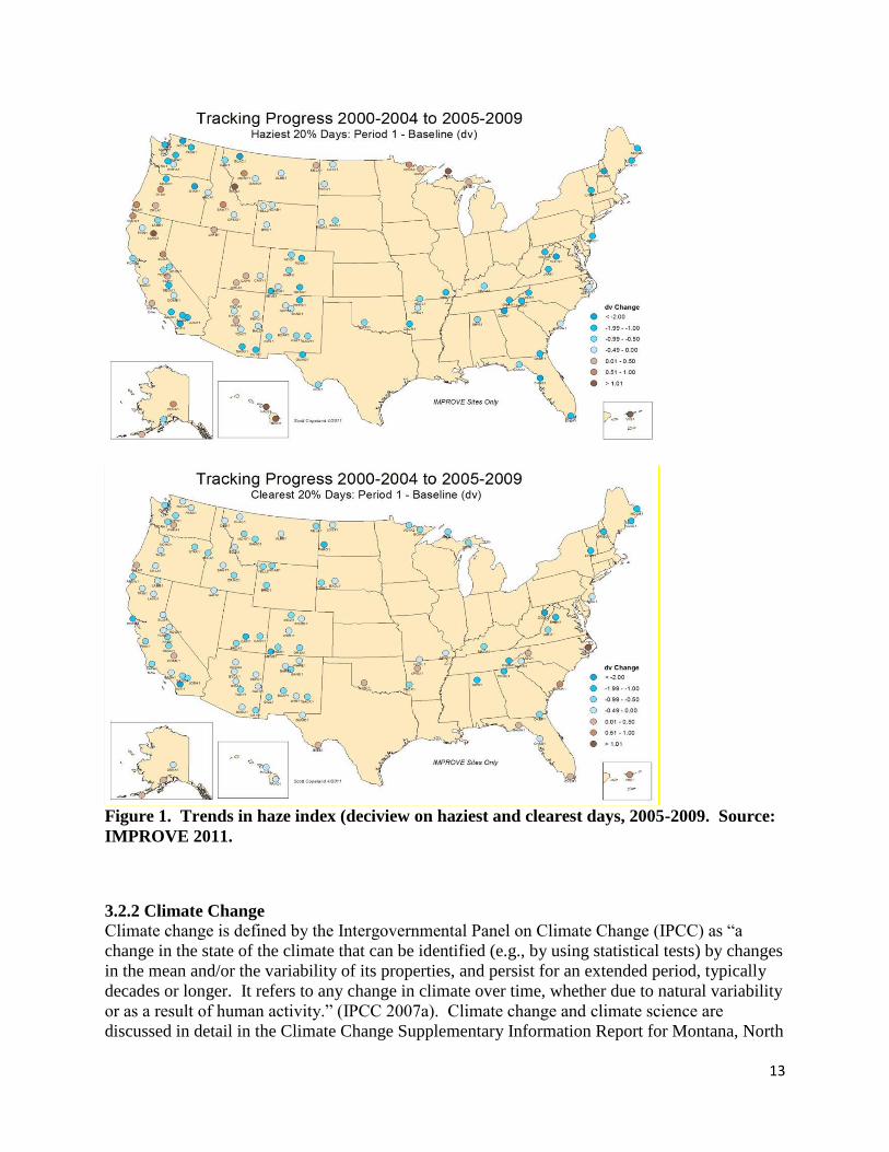
13
Figure 1. Trends in haze index (deciview on haziest and clearest days, 2005-2009. Source:
IMPROVE 2011.
3.2.2 Climate Change
Climate change is defined by the Intergovernmental Panel on Climate Change (IPCC) as “a
change in the state of the climate that can be identified (e.g., by using statistical tests) by changes
in the mean and/or the variability of its properties, and persist for an extended period, typically
decades or longer. It refers to any change in climate over time, whether due to natural variability
or as a result of human activity.” (IPCC 2007a). Climate change and climate science are
discussed in detail in the Climate Change Supplementary Information Report for Montana, North

14
Dakota, and South Dakota, Bureau of Land Management (Climate Change SIR, 2010). This
document is incorporated by reference into this EA.
The Intergovernmental Panel on Climate Change (Climate Change SIR, 2010) states, “Warming
of the climate system is unequivocal, as is now evident from observations of increases in global
average air and ocean temperatures, widespread melting of snow and ice, and rising global
average sea level.” Global average temperature has increased approximately 1.4°F since the
early 20th
century (Climate Change SIR 2010). Warming has occurred on land surfaces, oceans
and other water bodies, and in the troposphere (lowest layer of earth’s atmosphere, up to 4-12
miles above the earth). Other indications of global climate change described by IPCC 2007b
(Climate Change SIR 2010) include:
Rates of surface warming increased in the mid-1970s and the global land surface has
been warming at about double the rate of ocean surface warming since then;
Eleven of the last 12 years rank among the 12 warmest years on record since 1850;
Lower-tropospheric temperatures have slightly greater warming rates than the earth’s
surface from 1958-2005.
As discussed and summarized in the Climate Change SIR, earth has a natural greenhouse effect
wherein naturally occurring gases such as water vapor, CO2, methane, and N2O absorb and retain
heat. Without the natural greenhouse effect, earth would be approximately 60°F cooler (Climate
Change SIR 2010). Current ongoing global climate change is believed by scientists to be linked
to the atmospheric buildup of GHGs, which may persist for decades or even centuries. Each
GHG has a global warming potential that accounts for the intensity of each GHG’s heat trapping
effect and its longevity in the atmosphere (Climate Change SIR 2010). The buildup of GHGs
such as CO2, methane, N2O, and halocarbons since the start of the industrial revolution has
substantially increased atmospheric concentrations of these compounds compared to background
levels. At such elevated concentrations, these compounds absorb more energy from the earth’s
surface and re-emit a larger portion of the earth’s heat back to the earth rather than allowing the
heat to escape into space than would be the case under more natural conditions of background
GHG concentrations.
A number of activities contribute to the phenomenon of climate change, including emissions of
GHGs (especially CO2 and methane) from fossil fuel development, large wildfires, activities
using combustion engines, changes to the natural carbon cycle, and changes to radioactive forces
and reflectivity (albedo). It is important to note that GHGs will have a sustained climatic impact
over different temporal scales due to their differences in global warming potential (described
above) and lifespans in the atmosphere. For example, CO2 proper may last 50 to 200 years in the
atmosphere while methane has an average atmospheric life time of 12 years (Climate Change
SIR, 2010).
With regard to statewide GHG emissions, Montana ranks in the lowest decile when compared to
all the states (http://assets.openers.com/rpt/RL34272_20071205.pdf. Ramseur 2007). The
estimate of Montana’s 2005 GHG emissions of 37 million metric tons (MMT) of gross
consumption-based carbon dioxide equivalent (CO2e) account for approximately 0.6 percent of
the U.S GHG emissions (CCS 2007).

15
Some information and projections of impacts beyond the project scale are becoming increasingly
available. Chapter 3 of the Climate Change SIR describes impacts of climate change in detail at
various scales, including the state scale when appropriate. The EPA identifies eastern Montana
as part of the Great Plains region. The following summary characterizes potential changes
identified by the EPA (EPA, 2008) that are expected to occur at the regional scale, where the
Proposed Action and its alternatives are to occur.
The region is expected to experience warmer temperatures with less snowfall.
Temperatures are expected to increase more in winter than in summer, more at night than
in the day, and more in the mountains than at lower elevations.
Earlier snowmelt means that peak stream flow would be earlier, weeks before the peak
needs of ranchers, farmers, recreationalist, and others. In late summer, rivers, lakes, and
reservoirs would be drier.
More frequent, more severe, and possibly longer-lasting droughts are expected to occur.
Crop and livestock production patters could shift northward; less soil moisture due to
increased evaporation may increase irrigation needs.
Drier conditions would reduce the range and health of ponderosa and lodgepole pine
forests, and increase the susceptibility to fire. Grasslands and rangelands could expand
into previously forested areas.
Ecosystems would be stressed and wildlife such as the mountain lion, black bear, long-
nose sucker, marten, and bald eagle could be further stressed.
Other impacts could include:
Increased particulate matter in the air as drier, less vegetated soils experience wind
erosion.
Shifts in vegetative communities which could threaten plant and wildlife species.
Changes in the timing and quantity of snowmelt which could affect both aquatic species
and agricultural needs.
Projected and documented broad-scale changes within ecosystems of the U.S. are summarized in
the Climate Change SIR. Some key aspects include:
Large-scale shifts have already occurred in the ranges of species and the timing of the
seasons and animal migrations. These shifts are likely to continue (Climate Change SIR
2010). Climate changes include warming temperatures throughout the year and the
arrival of spring an average of 10 days to 2 weeks earlier through much of the U.S.
compared to 20 years ago. Multiple bird species now migrate north earlier in the year.
Fires, insect epidemics, disease pathogens, and invasive weed species have increased and
these trends are likely to continue. Changes in timing of precipitation and earlier runoff
would increase fire risks.
Insect epidemics and the amount of damage that they may inflict have also been on the

16
rise. The combination of higher temperatures and dry conditions have increases insect
populations such as pine beetles, which have killed trees on millions of acres in western
U.S. and Canada. Warmer winters allow beetles to survive the cold season, which would
normally limit populations; while concurrently, drought weakens trees, making them
more susceptible to mortality due to insect attack.
More specific to Montana, additional projected changes associated with climate change
described in Section 3.0 of the Climate Change SIR (2010) include:
Temperature increases in Montana are predicted to be between 3 to 5°F at the mid-21st
century. As the mean temperature rises, more heat waves are predicted to occur.
Precipitation increases in winter and spring in Montana may be up to 25 percent in some
areas. Precipitation decreases of up to 20 percent may occur during summer, with
potential increases or decreases in the fall.
For most of Montana, annual median runoff is expected to decrease between 2 and 5
percent. Mountain snowpack is expected to decline, reducing water availability in
localities supplied by meltwater.
Wind power production potential is predicted to decline in Montana based on modeling
focused on the Great Falls area.
Water temperatures are expected to increase in lakes, reservoirs, rivers, and streams. Fish
populations are expected to decline due to warmer temperatures, which could also lead to
more fishing closures.
Wildland fire risk is predicted to continue to increase due to climate change effects on
temperature, precipitation, and wind. One study predicted an increase in median annual
area burned by wildland fires in Montana based on a 1°C global average temperature
increase to be 241 to 515 percent.
While long-range regional changes might occur within this analysis area, it is impossible to
predict precisely when they could occur. The following example summarizing climate data for
the West North Central Region (MT, ND, SD, and WY) illustrates this point at the regional
scale. A potential regional effect of climate change is earlier snowmelt and associated runoff.
This is directly related to spring-time temperatures. Over a 112-year record, overall warming is
clearly evident with temperatures increasing 0.21 degrees per decade (Figure 2). This would
suggest that runoff may be occurring earlier than in the past. However, data from 1991-2005
indicates a 0.45 degree per decade cooling trend (Figure 3). This example is not an anomaly, as
several other 15-year windows can be selected to show either warming or cooling trends. Some
of these year-to-year fluctuations in temperature are due to natural processes, such as the effects
of El Ni os, La Ni as, and the eruption of large volcanoes (Climate Change SIR 2010). This
information illustrates the difficulty of predicting actual regional or site-specific changes or
conditions which may be due to climate change during any specific time frame.

17
Figure 2. Regional climate summary of spring temperatures (March-May) for the West North
Central Region (MT, ND, SD, WY), from 1895-2007. (Source: NOAA website –
http://www.ncdc.noaa.gov/oa/climate/research/cag3/wn.html)

18
Figure 3. Regional climate summary of spring temperatures (March-May) for the West North
Central Region (MT, ND, SD, WY), from 1991-2005. (Source: NOAA website –
http://www.ncdc.noaa.gov/oa/climate/research/cag3/wn.html)
3.3 Soil Resources
Soils were identified from the United States Department of Agriculture’s Natural Resources
Conservation Service’s (USDA-NRCS) Soil Survey Geographic (SSURGO) dataset and the Soil
Data Mart (SDM) website (http://soildatamart.nrcs.usda.gov/). Soil surveys were performed by
the USDA-NRCS according to National Cooperative Soil Survey (NCSS) standards. Soils within
the lease parcels developed from glacial till; residuum weathered from sandstone and siltstone;
and, alluvium from mixed sources. Landforms consist of nearly level to steep dissected glacial
till plains and hillslopes; moderately steep to steep hillslopes; and, nearly level to gently sloping
alluvial fans, terraces, and floodplains.
Table 3 breaks out the Soil Map Units within each lease parcel and provides acres and soil
ratings. Soil Map Unit descriptions are available from the SDM for the lease parcels.

19
Table 3. Soil Map Units and associated acres, slope range, and ratings for Lease Parcels
based on dominant condition of each Soil Map Unit. (Source: USDA-NRCS SSURGO
dataset (USDA-NRCS, 2013)).
Parcel Map Unit
Acres1
Slope
Range
(Percent)
Water
Erosion
Hazard2
Wind
Erosion
Hazard3
MTM102757-6J 57 55 1 - 9 Slight Slight
59 22 5 - 25 Moderate Slight
MTM102757-6L
2 75 0 - 3 Slight Slight
3 38 0 - 4 Slight Slight
47 40 1 - 9 Slight Slight
48 28 1 - 5 Slight Moderate
49 63 2 - 9 Slight Slight
74 10 0 - 5 Slight Slight
77 65 2 - 9 Slight Slight
MTM102757-6N
20 10 9 - 25 Moderate Slight
29 14 15 - 35 Severe Moderate
53 29 2 - 9 Slight Slight
54 67 9 - 35 Moderate Slight
57 20 1 - 9 Slight Slight
59 6 5 - 25 Moderate Slight
77 15 2 - 9 Slight Slight
MTM102757-6P
20 6 9 - 25 Moderate Slight
54 33 9 - 35 Moderate Slight
77 277 2 - 9 Slight Slight
1. Approximate acres of each MU ≥ 5 acres in size within the lease parcel. Approximate acres based on GIS calculations. 2. The water erosion hazard for bare, non-compacted, soil is estimated by using the formula: Water Erosion Hazard = Kw factor x
Representative Value (RV) Slope. The soil erodibility factor (Kw) quantifies soil detachment by runoff and raindrop impact.
This erodibility factor is an index used to predict the long-term average soil loss, from sheet and rill erosion. The Kw factor
applies to the whole soil, which includes rock fragments. Kw is based primarily on percentage of silt, sand, and organic matter, soil structure, saturated hydraulic conductivity, and rock fragments (USDA-NRCS, 2012). Representative Value (RV) Slope
indicates the expected slope value for a given MU.
3. The wind erosion hazard is estimated from the Wind erosion Index (WEI).The WEI is a numerical value indicating the susceptibility of soil to wind erosion, or the tons per acre per year that can be expected to be lost to wind erosion. This index is
divided into three rating classes: slight (0, 38, 48, 56), moderate (86), and severe (134, 160, 180, 220, 250, 310) (USDA-NRCS,
2012).
3.4 Water Resources
3.4.1 Surface Hydrology
Wetlands were identified from the United States Fish and Wildlife Service’s National Wetland
Inventory dataset. The U.S. Fish and Wildlife Service is the principal Federal agency that
provides information to the public on the extent and status of the nation’s wetlands. The
National Wetland Inventory dataset provides information on wetland type, location, and size.
There are a total of 2.81 acres of wetlands within the parcels nominated for lease sale (Appendix
D lists the wetlands that are present in the lease parcels). Wetland characteristics are
summarized in the acronyms that are used for identification. Wetlands within the lease parcels
may be one of the following types:
20
PEMA – [P] Palustrine, [EM] Emergent, [A] Temporarily Flooded
PABFh – [P] Palustrine, [AB] Aquatic Bed, [F] Semipermanently Flooded, [h] diked/Impounded
PABF – [P] Palustrine, [AB] Aquatic Bed, [F] Semipermanently Flooded
The U.S. Geological Survey’s National Hydrography Dataset (NHD) was used to identify
ephemeral and intermittent drainages within the lease parcels. The NHD is a feature-based
dataset that interconnects and uniquely identifies the stream segments or reaches that comprise
the nation’s surface water drainage system.
The analysis area consists of 3.17 miles of ephemeral and/or intermittent drainages (Appendix D
lists the drainages that are present in the lease parcels) within the Porcupine Creek Watershed.
These drainages are important as they represent the primary flow paths in the watershed and can
influence downstream water quality. While the National Hydrography Dataset indicates multiple
miles of flow paths, these are generally dry ephemeral drainages. The main stream systems fed
by surface water flow within the analysis area include Alkali Creek and the Middle Fork of
Porcupine Creek.
Porcupine Creek, from the confluence of the West Fork of Porcupine Creek and the Middle Fork
of Porcupine Creek to where Porcupine Creek flows into the Milk River (a total length of 49.3
stream miles), has been listed as water quality impaired. The probable causes of impairment for
Porcupine Creek are total nitrogen, total phosphorus, and salinity, with a probable source being
non-irrigated crop production. The parcels nominated for lease sale include stretches of the
Middle Fork of Porcupine Creek that reside from 22.91 to 26.80 stream miles upstream from the
confluence of the West and Middle Forks of Porcupine Creek.
3.4.2 Groundwater
Water well data available for Township 35 North, Range 40 East, indicates that the depth to the
water table ranges from 3 to 170 feet below surface with an average depth occurring at 63 feet
below surface. Water well data available for Township 34 North, Range 40 East, indicates that
the depth to the water table ranges from 5 to 80 feet below surface with an average depth
occurring at 47 feet below surface. There is a well in Township 34 North, Range 40 East, section
11 that is pulling water up from the Judith Formation at a depth greater than 400 feet below
surface.
The Montana Bureau of Mines and Geology publishes geologic maps that are intended primarily
as bedrock maps. Formations are defined through field investigations and by available
petroleum and groundwater well data. The map unit contacts are approximate as they are almost
always concealed.
The geology under the parcels nominated for lease, for the most part, include glacial till of
varying thicknesses that is overlying bedrock. Bedrock includes sand and gravel that is locally
cemented. The Claggett Shale is overlain by the Judith River Formation. The Judith River
Formation consists of up to 450 feet of gray, brown, and yellow mudstone; thin brown
sandstones; and thick multistory-multilateral channel deposits, all of fluvial origin. The Judith
21
River formation is a widely used source of groundwater with total dissolved solids levels
generally ranging from 800 to 2,000 milligrams/liter. Wells in the Judith River formation near
the Canadian border have an average yield of 3-4 gallons per minute (gpm) and a potential yield
of 20 gpm. The Bearpaw Shale is overlain by the Fox Hills Sandstone.
Appendix D lists the geologic map units that are present directly under each of the lease parcels.
Map Units
Qsg (Quaternary) Sand, gravel, silt or clay on floodplains of modern channels and in
or adjacent to former channels. Includes terrace deposits, glacial outwash, and
colluvium.
Tsg (Tertiary) Sand and gravel deposits. Predominantly sand and gravel, locally
cemented with calcium carbonate. Up to 100 feet thick.
Tfu (Tertiary) Fort Union Formation: includes, from top to base, Tongue River
Members, Lebo, and the Tullock. Maximum thickness (northeast of the analysis
area) is 500 feet. Formation primarily consists of unconsolidated to semi-
consolidated sand and shale.
Khc (Upper Cretaceous) Hell Creek Formation: averages about 250 feet thick. The
upper portion is primarily composed of siltstone. The sandstone content increases
toward the base of the formation. Where the formation is adequately recharged, it
is a productive aquifer.
Kfh (Upper Cretaceous) Fox Hills Sandstone: underlies the Hell Creek Formation
(Khc) and has a maximum thickness of 150 feet. This formation offers a higher
water well yield than the Hell Creek Formation.
Kb (Upper Cretaceous) Bearpaw Shale: maximum thickness is about 1,100 feet.
3.5 Vegetation Resources
3.5.1 Vegetation Communities: Upland
The vegetation within the analysis area is characteristic of the Northern Dark Brown Glaciated
Plains in the 10 to 14-inch precipitation zone, which lies within the Northern Great Plains. The
Northern Great Plains is known for its diverse vegetation types, soil types, and
topography. Vegetation is comprised of both tall and short grasses as well as both warm and
cool season grasses. A variety of grass-like plants, forbs, shrubs and trees also add to the
vegetation diversity of this rangeland type. Plant species diversity increases in woody draws and
riparian/wetland zones.
Existing influences on local distribution of plant communities include soils, topography, and
surface disturbance, availability of water, management boundary fence lines, and soil salinity.
22
Vegetation communities have been affected by human activities for over a century. Some of
these activities include: infrastructure developments (roads, power lines, pipelines, etc.),
chemical applications, logging, livestock grazing, farming, and wildfire rehabilitation,
prevention, manipulation, and suppression.
The BLM Standards of Rangeland Health (Standards) for BLM administered lands address
upland health, riparian health, air quality, water quality, and habitat for native plants and
animals. Meeting these Standards ensures healthy, productive, and diverse vegetative resources
on public lands. The BLM’s policy for implementing the Standards for Rangeland Health (43
CFR §4180.2) provides that all uses of public lands are to complement the established rangeland
standards. Application of 43 CFR §4180.2 provides the mechanism to adjust livestock grazing to
meet or progress towards meeting Standards for Rangeland Health. Effects of other uses such as
oil and gas development or off- highway vehicle use are evaluated against the Standards to
provide rationale directing management of these uses.
Five vegetation communities have been identified within the analysis area: native mixed grass
prairie, sagebrush/mixed grasslands, agricultural lands, improved or restored pastures, and
riparian-wetlands.
There are numerous ecological sites identified within the analysis area, but the primary ones
include the following; Claypan (Cy), Sandy (Sy), Sandy-Steep (SyStp), Shallow (Sw), Shallow
Clay (SwC), Silty (Si), and Silty- Steep (SiStp). The total dry-weight production expected to be
found on these sites during a normal growing season ranges from approximately 800 to 1,500
lbs. /acre.
The native mixed grassland community is dominated by perennial grasses. Perennial grasses can
be both warm season and cool season grasses. These perennial grasses can also be both tall and
short grasses. Some of the more common grasses include western wheatgrass
(Pascopyrum smithii), needle-and-thread (Hesperostipa comata), green
needlegrass(Nassella viridula), blue grama (Bouteloua gracilis), and prairie
junegrass (Koeleria macrantha). Various forbs and shrubs are present but, occur as a minor
species composition component throughout the community.
The sagebrush/ mixed grassland community occurs on lower valley slopes near drainages,
especially where soils are deeper. This community can include a combination of silver
sagebrush (Artemisia cana) and Wyoming big sagebrush (Artemisia tridentata
ssp. wyomingensis). This setting is common throughout the analysis area with silver sagebrush
being more dominant. The sagebrush/grassland vegetation community has a perennial grass and
forb understory, similar to the species found in a mixed native grassland community. The
expected species composition on this community consists of 70-75% native grass species, 10-
15% forbs, and 5-10% shrubs and half-shrubs. This community type comprises a very small
portion of the project area.
Improved or restored pastures consists of cultivated areas planted with introduced grasses
(crested wheatgrass, smooth brome (Bromus inermis), intermediate wheatgrass
23
(Thinopyrum intermedium), and alfalfa (Medicago sativa), specifically for the improved
vegetation production for livestock consumption. This setting is limited in the analysis area.
The cultivated plant community is comprised of monocultures of crops which may include small
grains, alfalfa, or other crops grown primarily as supplemental feed sources for livestock
production operations. These areas have been completely disturbed from the native vegetation
potentials. This setting is common in the analysis area.
3.5.2 Vegetative Communities: Wetland/Riparian
Riparian and wetland areas are the green zones bordering lakes, rivers, reservoirs, estuaries,
potholes, springs and seeps, and perennial, intermittent, or ephemeral streams where the water
table is usually at or near the surface. The riparian zone is the interface or linkage between the
upland (terrestrial) zone and the aquatic zone and is generally more productive in terms of total
biomass than the remainder of the area. Characteristically, riparian and wetland areas display a
greater diversity of plants, fish, and wildlife than adjoining ecosystems. Healthy riparian
systems filter and purify water as it moves through the riparian-wetland zone, reduce sediment
loads and enhance soil stability, profile micro-climate moderation when contrasted to
temperature extremes in adjacent areas, and contribute to ground water recharge and base flow.
There are a total of 2.81 acres of wetlands within the parcels nominated for lease sale (Appendix
D lists the wetlands that are present in the lease parcels). The waterbodies that support wetland
vegetation are either temporarily or semipermanently flooded and are primarily manmade
impounds.
The BLM assesses the functioning condition of riparian zones along streams on BLM surface
owned lands. As the analysis area does not include BLM surface, and the Middle Fork of
Porcupine Creek does not flow across BLM land in Valley County, no records of the functioning
condition of the riparian zones along the intermittent and/or ephemeral drainages within the
parcels nominated for lease are currently available.
Some of the more common vegetative species that occur in wetlands and riparian zones include
prairie cordgrass (Spartina pectinata), switchgrass (Panicum virgatum), Canada wildrye (Elymus
Canadensis), western wheatgrass (Pascopyrum smithii), willow (Salix spp.), chokecherry
(Prunus virginiana), buffaloberry (Shepherdia), water sedge (Carex aquatilis), plains
cottonwood (Populus deltoids occidentalis), sedges (Carex spp.), rushes (Juncus spp.), smooth
brome (Bromus inermis), wild rose (Rosa spp.), sago pondweed (Stuckenia pectinata),
sloughgrass (Beckmannia), curlycup gumweed (Grindelia squarrosa), Kentucky bluegrass (Poa
pratensis), and snowberry (Symphoricarpos spp.).
3.5.3 Vegetative Communities: Invasive, Non-Native Species, Noxious Weeds
All of the parcels are split estate with private surface over federal minerals. Noxious weeds
currently found in Valley County include leafy spurge, Russian knapweed, field bindweed,
Canada thistle, cheatgrass and field brome. Noxious weed control on private land is the
responsibility of the landowner or in the case of CRP (Conservation Reserve Program), the
Natural Resources Conservation Service. The BLM works collaboratively with the Valley

24
County Weed District to control and prevent the spread of noxious and invasive species on
public and private lands. Noxious weeds that are introduced as a result of oil and gas
development on split estate require coordination between the landowner and the oil and gas leas
operator to control the infestation.
3.6 Special Status Species
Special Status Species can be Federally listed threatened, endangered, candidate or proposed
fish, wildlife or plant species; BLM listed Sensitive Species; or those Special Status Species
maintained on lists by the USFWS; Montana Department of Fish, Wildlife and Parks; Montana
Natural Heritage Program; or other non-governmental organizations.
Although listed threatened or endangered species are unlikely to occur on the lease parcels at
present, the TES 16-2 stipulation for threatened or endangered species would be attached to the
leases in the event that listed species are observed, or in case any future listed species are likely
to occur on the lease parcels. Some of the Standard Stipulations and Notice (16-3) also could
apply to Special Status Species. For instance, Sprague’s pipit would be attached to protect its
habitat if the habitat should improve prior to any future development, or if the Sprague’s pipit
should be listed by that time.
3.6.1 Special Status Animal Species
3.6.1.1 Aquatic Wildlife
BLM Special Status fish species do not occur in or near any of the proposed lease parcels.
3.6.1.2 Terrestrial Wildlife
BLM Listed Sensitive Species that are found within Valley County, which encompasses the
Glasgow Field Office and may occur on or near the proposed parcels. Some of those species
include a wide variety of neotropical migratory birds such as raptors, songbirds, grassland
obligate birds, and waterfowl.
3.6.1.2.1 Threatened, Endangered, Candidate, and Proposed Species
According to the U.S. Fish and Wildlife Service there are 5 listed species and 2 candidate
species. Those species are Pallid Sturgeon, Piping Plover, Black-footed ferret, Interior Least
Tern, and Whooping Crane. The nominated parcels do not contain habitat to support the 5 listed
species.
The BLM Sensitive Species Greater Sage-Grouse was petitioned for listing under the
Endangered Species Act with a March 2010 finding that listing for the species was warranted but
precluded. This moved the Greater Sage-Grouse into “candidate” status with an annual status
review. The nominated parcels are outside of Greater Sage-Grouse habitat.
Listing of the Sprague’s pipit as a T&E Species was determined on 14 September 2010 to be
warranted, but precluded due to the need to work on higher priority species. The Sprague’s pipit
thus became a candidate species with an annual status review to determine eligibility for listing.
The Sprague’s pipit generally avoids cultivated land, although introduced grass cover can be
used for nesting if native grass cover is not present in the near vicinity.

25
3.6.2 Special Status Plant Species
According to the MTNHP, there is no known threatened or endangered plant species located
within the lease parcels in the Glasgow Field Office. Five plant species on the Montana Plant
Species of Concern list have been identified as having suitable habitat in areas near these parcels
(MTNHP, 2013). These species are listed in Table 4 and have the potential to exist on the lease
parcels. Three of these species are also identified as BLM “Sensitive” plants.
According to the MTNHP field guide, these plants are typically found in very specific habitats
and do not occur predictably across the landscape. Not much is known of the status of these
species in the analysis area, although the general condition and trend of these habitats could be
used to estimate the specific conditions until the sites can be revisited and site-specific data
collected.
Table 4. MT Species of Concern and BLM Sensitive Plants with potential on or near lease
parcels
Plant Name Counties it occurs in Habitat description
Scarlet Ammannia Phillips, Valley,
Yellowstone Wetland/Riparian
Chaffweed Lake, Missoula, Phillips,
Powell, Ravalli, Sheridan,
Valley Wetland/Riparian
Hot Spring Phacelia* Fergus, Garfield, Phillips,
Valley Barren clay slopes
Bractless blazingstar* Custer, Powder River,
Roosevelt, Rosebud,
Valley Open areas (sandy or gravelly soils)
Platte Cinquefoil* Beaverhead, Judith Basin,
Valley Grasslands/sagebrush (Mesic)
*Denotes BLM sensitive species
3.7 Fish and Wildlife
3.7.1 Aquatic Wildlife
There are no fish species that occur within the proposed parcels.
3.7.2 General Wildlife
The proposed parcels are split estate ownership and is mainly cultivated land. White-tailed deer
have been observed in the area as well as a wide variety of neotropical birds such as raptors,
grassland obligate songbirds, waterfowl and upland game birds such as sharp-tailed grouse
(Tympanuchus phasianellus), mourning dove (Zenaida macroura), and the introduced rig-necked
pheasant (Phasianus colchicus). Mesocarnivores and a variety of shrews, rodents and other
small mammals are also present on the parcels.
Although there are no flowing streams within the nominated parcels but during spring runoff, the
drainages may contain water that would provide habitat for a variety of amphibians and reptiles

26
such as tiger salamander (Ambystoma tigrinum), eastern racer (Coluber constrictor), plains garter
snake (Thamnophis radix), gophersnake (bullsnake) (Pituophis catenifer), and western
rattlesnake (Crotalus viridis).
3.8 Cultural Resources
The BLM is responsible for identifying, protecting, managing, and enhancing cultural resources
which are located on public lands, or that may be affected by BLM undertakings on non-Federal
lands, in accordance with the National Historic Preservation Act (NHPA) of 1966, as amended.
The procedures for compliance with the NHPA are outlined in regulation under 36 CFR 800, as
well as both national and state level programmatic agreements between BLM and the State
Historic Preservation Office (SHPO)
Cultural resources include archaeological, historic, and architectural properties, as well as
traditional life-way values and/or traditional cultural properties important to Native American
groups.
Of the four parcels identified no level of existing Class III Cultural Resource inventory has
occurred to date within the proposed lease parcel boundaries with one exception T34N, R40E,
Sec. 4 has had one Class III inventory (85-MT-060-1) performed for the purpose of a proposed
land exchange. No Historic Properties have been recorded to date in any of the aforementioned
parcels.
3.9 Native American Religious Concerns
BLM’s management of Native American Religious concerns is guided through its 8120 Manual:
Tribal Consultation Under Cultural Resources Authorities and 8120 Handbook: Guidelines for
Conducting Tribal Consultation. Further guidance for consideration of fluid minerals leasing is
contained in BLM Washington Office Instruction Memorandum 2005-003: Cultural Resources,
Tribal Consultation, and Fluid Mineral Leasing. The 2005 memo notes leasing is considered an
undertaking as defined in the National Historic Preservation Act. Generally areas of concern to
Native Americans are referred to as “Traditional Cultural Properties” (TCPs) which are defined
as cultural properties eligible for the National Register because of its association with cultural
practices or beliefs that (a) are rooted in that community’s history and (b) are important in
maintaining the continuing cultural identity of the community.
The area that makes up the proposed lease parcels was at one time the aboriginal lands of
multiple tribes. These tribes include Piegan, Blood, Blackfeet, Gros Ventre, Assinboine, Sioux,
Flathead (Salish), and Cree Tribes.
Previous consultation with tribes indicates that they use certain areas for religious and cultural
purposes. Certain types of archaeological sites have cultural and religious significance. These
include vision quest sites, monumental/ anthropomorphic/zoomorphic rock features, rock art
sites, burials, habitation sites with special purpose ceremonial structures, and ceremonial and/or
dance grounds. No defined Traditional Cultural Properties have been identified within the
proposed lease parcels

27
3.10 Paleontology
According to Section 6301 of the Paleontological Resource Protection Act of 2009 Omnibus
Public Lands Bill, Subtitle D, SEC. 6301, paleontological resources are defined as “any
fossilized remains, traces, or imprints of organisms, preserved in or on the earth’s crust, that are
of paleontological interest and that provide information about the history of life on earth”
(Paleontological Resource Protection Act of 2009 Omnibus Lands Bill, Subtitle D, SEC. 6301-
3612 (P.L. 59-209; 34 Stat. 225; 16 U.S.C. 431-433). All vertebrate fossils, be they fossilized
remains, traces, or imprints of vertebrate organisms, are considered significant. Paleontological
resources do not include archaeological and cultural (typically human graves) resources.
The BLM utilizes the Potential Fossil Yield Classification (PFYC) as a planning tool for
identifying areas with high potential to yield significant fossils. The system consists of numbers
ranging from 1-5 (low to high) assigned to geological units, with 1 being low potential and 5
being high potential to have significant fossil resources. It should be pointed out that the
potential to yield significant fossil resources is never 0. Rock units not typically fossiliferous can
in fact contain fossils in unique circumstances.
BLM classified geologic formations that have a high Potential Fossil Yield Classification
(PFYC) of 3 or higher should be specifically reviewed for paleontological resources prior to
surface disturbing activities, and rankings of 4 and 5 may require on-site monitoring during
surface disturbing activities. The Glasgow Field Office has the following classifications on the
relevant geologic units:
Formation Rank
Sand & Gravel (Qsg) 3
Sand & Gravel (Tsg) 3
Fort Union (Tfu) 4
Hell Creek (Khc) 5
Bearpaw (Kb) 3
Fox Hills (Kfh) 5
All or part of 4 lease parcels (MTM 102757-6J, 6L, 6N, and 6P) include geologic units rated as
PFYC 3-5.
3.11 Visual Resources
Visual Resource Management (VRM is BLM’s systematic approach to inventorying and
managing visual resource values, as mandated by Federal legislation (FLPMA, 1976 and NEPA,
1969). It includes the evaluation of public lands for assignment of inventory classes during
Resource Management Plan (RMP development, as well as the determination of management of
Visual Resource Management (VRM) classes and the routine operational management of those
28
classes. The VRM enables the BLM to have a system for managing the human concern for
scenery and public acceptance for visible changes to the natural landscape setting. Through this
system the BLM is able to objectively measure proposed landscape altering projects for
compliance to visual performance standards and apply the use of good design principles to
satisfy management objectives.
BLM manages landscapes according the Visual Resource Management Manual (H-8431-1)
VRM Classes and establish specific objectives on the management of visual resource values.
The VRM objectives set the standards for the planning, design, and evaluation of proposed
projects. The VRM classes consider the compatibility between land use decisions and visual
values. Management Objectives range from preserving the natural landscape (VRM Class I) to
providing for activities which require major modification of the existing landscapers (VRM class
IV).
A Class I VRM area means that the objective is to preserve the existing landscape. This class
provides for natural ecological changes; however it does not preclude very limited management
activity. The level of change to the characteristic landscape should be very low and must not
attract any attention of a casual observer.
A Class II VRM area classification means that the character of the landscape has unique
combinations of visual features such as land, vegetation, and water. The existing character of the
landscape should be retained. Activities or modifications of the environment should not be
evident or attract the attention of the casual observer. Changes caused by management activities
must repeat the basic elements of form, line, color, and texture found in the predominant natural
features of the characteristic landscape.
A Class III VRM area classification means the level of change to the character of the landscape
should be moderate. Changes caused by management activities should not dominate the view of
the casual observer and should not detract from the existing landscape features. Any changes
made should repeat the basic elements found in the natural landscape such as form, line, color
and texture.
A Class IV VRM area classification means that the characteristic landscape can provide for
major modification of the landscape. The level of change in the basic landscape elements can be
high. However, every attempt should be made to minimize the impact of these activities through
careful location, minimal disturbance, and repeating the basic elements.
The proposed project is within a VRM Class IV area. The project conforms with the objectives
of this classification, however, every attempt should be made to minimize the impacts of the
activities through careful location, minimal disturbance and repeating the basic elements of form,
line, color, and texture in the natural characteristic landscape.
Table 5. VRM Classes for the analysis area
Leasing Areas VRM Class II Acres VRM Class III Acres VRM Class IV Acres
Valley County 0 acres 0 acres 880.15 total acres

29
MTM102757-6L 0 0 320
MTM102757-6N 0 0 160
MTM102757-6P 0 0 320
MTM102757-6J 0 0 80.15
Assessing scenic values and determining visual impacts can be a somewhat subjective process.
Objectivity and consistency can be greatly increased by using the basic design elements of form,
line, color, and texture, which have often been used to describe and evaluate landscapes, to also
describe proposed projects. Projects that repeat these design elements are usually in harmony
with their surrounding; those that don’t create contrast. By adjusting project designs so the
elements are e repeated, visual impacts can be minimized.
3.12 Forest and Woodland Resources
This resource is not present on any of the parcels and will not be discussed further.
3.13 Livestock Grazing
None of the lease parcels proposed to be leased for oil and gas in the Project Area conflict with
current permits and contracts for grazing allotments awarded on federal lands. Therefore, this
subject will not be discussed further in this document.
3.14 Recreation and Travel Management
3.14.1 Recreation
The BLM has an important niche in recreation in Montana, providing opportunities for Off-
highway vehicle use, camping, hiking, driving for pleasure, picnicking, hunting, whitewater
rafting, wildlife viewing, and a wide variety of other pursuits. This role in outdoor recreation is
under stress from changing populations, new technologies, and access issues. Population
increases are placing additional demands on recreational use of BLM lands. Traditional as well
as new forms of recreational activities such as photography, hunting and OHV use, are
increasing in popularity. There is also a growing concern for preserving the character and
resources upon which this recreation depends.
The BLM Recreational Strategy is to improve access to appropriate recreational opportunities
and experiences; ensure a quality experience and enjoyment of natural and cultural resources,
and; provides for and receives fair value in recreation.
The BLM has shifted from an activity -based to an outcome -focused management (OFM)
recreation resources. This means that emphasis is put on providing a certain type of recreational
experience which, in turn, produces a variety of personal, community, economical, and
environmental benefits rather than focusing on specific activities and the facilities associated
with those activities. For the HiLine District these recreation settings are generally more
primitive and rugged, requiring more individual responsibility, and have an overall lower density
and demand than lands managed by other agencies. This is the case for all the lands covered in
this lease proposal.

30
The proposed project is within the Valley ERMA. There are no developed recreation sites in the
proposed project area and recreation is mostly low and dispersed. The BLM parcels in the area
are relatively small and surrounded by private lands. There are no commercial, competitive, or
organized operators currently conducting recreational activities on any of these parcels. The
action of leasing these parcels would not by itself change any recreational opportunity or
experience.
3.15 Lands and Realty
All parcels are split estate; the surface estate is fee title and the mineral estate is federal.
However, for one parcel, the federal government only has title to 50% of the mineral estate. The
other half is non-federal. Because the surface is private, there are no BLM authorized rights-of-
way or development and thus, Lease Notice 14-1 is not applicable. Therefore any discussion
related to Lands and Realty will not be discussed further.
3.16 Minerals
3.16.1 Fluid Minerals
It is the policy of the BLM to make mineral resources available for disposal and to encourage
development of these resources to meet national, regional, and local needs, consistent with
national objectives of an adequate supply of minerals at reasonable prices. At the same time, the
BLM strives to assure that mineral development occurs in a manner which minimizes
environmental damage and provides for the reclamation of the lands affected.
Currently there are 99 federal oil and gas leases covering approximately 57,590 acres in lands
administered by the GFO. The number of acres leased and the number of leases can vary on
daily basis as leases are relinquished, expired, or are terminated. Information on numbers and
status of wells on these leases and well status and numbers of private and state wells within the
external boundary of the field office is displayed in Table 6. Numbers of townships, leases acres
within those townships, and development activity for all jurisdictions are summarized in Table 7.
Exploration and development activities would only occur after a lease is issued and the
appropriate permit is approved. Exploration and development proposals would require
completion of a separate environmental document to analyze specific proposals and site-specific
resource concerns before BLM approved the appropriate permit.
Table 6. Existing Development Activity on Lands Administered by the GFO
FEDERAL WELLS PRIVATE AND STATE WELLS
Drilling Well(s) 2 0
Producing Gas Well(s) 60 84
Producing Oil Well(s) 0 0
Water Injection Well(s) 0 0
Shut-in Well(s) 3 4
Temporarily Abandoned Well(s) 0 1

31
Table 7. Oil and Gas leasing and Existing Development within Townships Containing
Lease Parcels
Valley County
Number of Townships Containing Lease
Parcels
2
46080 Total Acres Within Applicable
Township(s)
Acres of Federal Oil and Gas Minerals 1840*
4% Percent of Township(s)
Acres of Leased Federal Oil and Gas
Minerals
0**
0% Percent of Township(s)
Acres of Leased Federal Oil and Gas
Minerals Suspended
0
0.2%
Percent of Township(s)
Federal Wells No Drilling, producing, shut in, or TA wells.***
Private and State Wells No Drilling, producing, shut in, or TA wells.***
*From Mater title Plat dated 11/12/2010 for 34N 40E and 1/25/2011 for 35N 40E **From Oil & Gas Plat dated 11/12/2010 for 34N 40E and 1/25/2011 for 35N 40E
***Source: AFMSS, MBOG 04/09/2013
3.16.2. Solid Minerals
3.16.2.1. Coal
There is no current coal production in the lease parcel areas. Information was verified utilizing
the economic coal deposits GIS layer. No proposed lease parcels are lying over any leased coal
deposits.
3.16.2.2. Locatable Minerals
Locatable minerals are subject to provisions of the 1872 Mining Law. These generally include
metallic minerals such as gold and silver and other materials not subject to lease or sale. There is
currently no locatable mineral production or potential for production in the lease parcel areas.
3.16.2.3. Salable Minerals
Salable minerals (mineral materials) are those common varieties of sand, stone, gravel, cinders,
pumice, pumicite, and clay that may be acquired under the Materials Act of 1947. Mineral
materials are disposed of by free-use and community/common-use permits granted to
municipalities or non-profit entities, respectively. Contracts for sale of mineral materials are
offered to private entities on both a competitive and non-competitive basis. Disposal of salable
minerals is a discretionary decision of the BLM authorized officer. Future potential resource
development conflicts would be avoidable either by not issuing sales contracts in oil and gas
development locations or conditioning the APD or salable mineral contracts in a manner to avoid
conflicts between operations.
32
None of the lease parcels proposed to be leased for oil and gas in the Project Area conflict with
current permits and contracts for salable minerals awarded on federal lands. Therefore, this
subject will not be discussed further in this document.
3.17 Special Designations he listed as not discussed – currently they are all NL areas
3.17.1 National Historic/Scenic Trails
There are portions of two National Historic and Scenic Trails which pass through the lands
managed by the HiLine District. They are the Lewis and Clark National Historic Trail and the
Nez Perce National Historic Trail. Neither of these trails passes through any of the parcels
covered in this proposal.
3.17.2 Areas of Critical Environmental Concern (ACECs) The Federal Land Policy and management Act (FLPMA) requires that priority shall be given to
the designation and protection of ACECs. Areas of Critical Environmental Concern are defined
in the FLPMA Sec. 103[43 W.S.C 1702] (a) and in 43 C.F.R. 1601-05(a) as “areas within the
public lands where special management attention is required to protect and prevent irreparable
damage to important historical, cultural, or scenic values, fish and wildlife resources or other
natural systems or processes, or to protect life and safety from natural hazards.”
There are seven ACECs in the HiLine District but none of these designated lands are located
within or adjacent to the proposed lease parcels.
3.18 Social and Economic Conditions
3.18.1 Social and Environmental Justice
Introduction
Certain existing demographic and economic features influence and define the nature of local
economic and social activity. Long-held customs, social cohesion, and history of an area provide
valuable insight into how events or changes to the area may affect the livelihood and quality of
life of the residents. While linkages exist across various social environments, the affected social
environment consists of Valley County, Montana.
Affected Environment
Valley County has a rich agricultural history which continues today. Glasgow, the county seat,
was a railroad town that brought many of the ranchers and farmers into the area
(GlasgowMontana.com, 2013). Other communities in the County include Fort Peck, Frazer,
Glentana, Hinsdale, Nashua, Opheim, Richland, St. Marie, and Vandalia. The estimated total
population of Valley County in 2011 was 7,487 (US Census Bureau, 2013a). Agriculture is still
important to the County. Valley County has 770 farms and 2,061,260 acres in farms (NASS,
2007). In 2011, the County ranked number one for spring wheat production, number four for
durum wheat production, and number 5 for alfalfa production. It ranked number sixteen in 2012
for cattle (NASS, 2012).
Environmental Justice
Executive Order 12898, Federal Action to Address Environmental Justice in Minority
Populations and Low-Income Populations, requires the identification and addressing of
33
disproportionately high and adverse human health and environmental impacts of federal
programs, policies, and activities on minority and low-income populations. We used the
following criteria to determine if there was an environmental justice population:
At least one-half of the population is of minority or low-income status, and
The percentage of the population that is of minority or low-income status is at least 10
percent higher than for the entire State of Montana.
The population’s race and ethnicity for the study area and the State of Montana, respectively, in
2011 was: White alone (87.0%, 89.9%); Black or African American alone (0.4%, 0.5% );
American Indian and Alaska Native alone (10.0%, 6.4%); Asian alone (0.5%, 0.7%); Native
Hawaiian and other Pacific Islander alone (0.0%, 0.1%); two or more races (2.1%, 2.4%); and,
Hispanic (1.6%, 3.1%) (US Census Bureau, 2013a, US Census Bureau, 2013b). Note that these
percentages will not add up to 100% because Hispanic can be of any race. The poverty level for
all ages in Valley County in 2011 was 15.3%, and for the State of Montana it was 15.2%. (US
Census Bureau, 2013c). Neither the minority nor low-income status in the study area meets the
above criteria.
3.18.2 Economics
Introduction
Certain existing demographic and economic features influence and define the nature of local
economic and social activity. Among these features are the local population, the presence and
proximity of cities or regional business centers, longstanding industries, infrastructure,
predominant land and water features, and unique area amenities. The local economic impact
area extends beyond the Field Office boundaries because of economic linkages to areas outside
the Field Office boundaries. The affected local economy is made up of Valley Counties within
the BLM Glasgow Field Office boundaries as well as Phillips, Blaine, and Hill Counties. Blaine
and Hill Counties are included because of the oil and gas related businesses that work in oil and
gas fields in Phillips and Valley counties. While public revenues from oil and gas leasing, rent,
and production addressed in this EA are only distributed to Valley counties, employment and
income effects are spread across the four counties. The distribution of these economic effects is
based on acres leased and levels of production as well as business patterns.
Affected Environment
The four-county local economy had an estimated 2010 population of 33,970 people. Total
employment was estimated to be 21,350 jobs; there were an estimated 13,098 households; and
there were 154 IMPLAN industrial sectors represented in the local economy (IMPLAN, 2010).
The local economy includes Glasgow, Havre and Malta (local population, business, and oil field
service centers). There were 1.59 people per job within the local economy and 0.61 households
per job.
Nature of the Oil and Gas Industry in the Malta Field Office
In March 2013, BLM had leases in effect covering 53,285 acres in Valley County. Annual lease
rent is paid on 27,233 acres that are not held by production on leases with oil/gas being produced
from one or more wells. Lease rent was not paid on 26,025 acres that were held by production.
Instead, royalties are paid on oil and gas production from these leases.
34
Local oil and gas exploration, development, and production as well as gas pipeline transmission
industry all support jobs and income in the local economy.
A portion of the oil and gas-related revenues collected by the federal government is distributed to
the state and counties. The amount that is distributed is determined by the federal authority
under which the federal minerals are being managed. The leased acres change daily as some
leases expire and other parcels are leased. Within the Glasgow Field Office, public domain
federal minerals account for about 66 percent of the acres leased; acquired lands/minerals,
mostly Bankhead-Jones lands, account for about 34 percent of acres leased.
Forty-nine percent of these federal leasing revenues from public domain minerals are distributed
to the state and the state distributes 25% back to the counties (Title 17-3-240, Montana Code
Annotated). Twenty-five percent of the federal leasing revenues from acquired minerals are
distributed from the federal government to the counties of production.
Leasing
Federal oil and gas leases generate a one-time lease bonus bid as well as annual rents. The
minimum lease bid is $2.00 per acre. If parcels do not receive the minimum bids they may be
leased later as noncompetitive leases that don’t generate bonus bids. Within Valley County,
bonus bids averaged $2.00 per acre on federal leases issued between 2008 and 2012.
Lease rent is $1.50 per acre per year for the first five years and $2.00 per acre per year thereafter.
Typically, oil and gas leases expire after 10 years unless held by production. Annual lease rent
continues until one or more wells are drilled that result in production and associated royalties.
Currently, the federal government collects an estimated annual average of about $58,000 in lease
bids and rent from leases in Valley County; of which about $26,000 is distributed to the
state/local governments.
Production
Federal oil and gas production in Montana is subject to production taxes or royalties. These
federal oil and gas royalties generally equal 12.5 percent of the value of production (43 CFR
3103.3.1). Forty-nine percent of the royalties from public domain federal minerals are
distributed to the state, of which 25 percent is distributed back to the county of production (Title
17-3-240, MCA). Twenty-five percent of the federal royalty revenues from acquired minerals
are also distributed from the federal government to the counties of production.
An annual average of 739,976 MCF of natural gas is produced from BLM-administered federal
minerals in the Valley County.
Local Economic Contribution
The economic contribution to a local economy is measured by estimating the employment and
labor income generated by 1) payments to counties associated with the leasing, rent, and
production of federal minerals, 2) local royalty payments associated with production of federal
oil and gas, and 3) economic activity generated from drilling and associated activities.
Activities related to oil and gas leasing, exploration, development, and production form a basic
industry that brings money into the state and region and creates jobs in other sectors. Extraction
of oil and natural gas (IMPLAN sector 20), drilling oil and gas wells (IMPLAN sector 28), and
support activities for oil and gas operations (IMPLAN sector 29) supported an estimated 317

35
total jobs and $15.8 million in total employee compensation and proprietor income in the local
economy (IMPLAN, 2010).
Total average annual federal revenues from federal oil and gas leasing, rents, and royalty
payments within Valley County are an estimated $395,000. Federal revenues distributed to the
state of Montana amount to an estimated $163,000 per year. The state redistributes an estimated
$66,000 per year to Valley County. These revenues help fund traditional county functions such
as enforcing laws, administering justice, collecting and disbursing tax funds, providing for
orderly elections, maintaining roads and highways, providing fire protection, and/or keeping
records. Other county functions that may be funded include administering primary and
secondary education and operating clinics/hospitals, county libraries, county airports, local
landfills, and county health systems.
The estimated annual local economic contribution associated with federal leases, rents, drilling,
production, and royalty payments combines to support about one local job and about $30,000 in
local labor income, respectively. These contributions equal less than one percent of the local
employment and local income. Table Econ. 1 shows the current contributions of leasing federal
oil and gas minerals and the associated exploration, development, and production of federal oil
and gas minerals to the local economy.
Table 8. Current Contributions of Federal Oil and Gas Leasing, Exploration,
Development, and Production to the Local Economy
Employment (jobs)
Labor Income (Thousands of 2010
dollars)
Industry
Area
Totals
Federal O&G -
Related Area Totals
Federal O&G-
Related
Agriculture 3,724 0 $26,821 $0
Mining 353 0 $19,979 $7
Utilities 110 0 $11,455 $1
Construction 1,100 0 $37,114 $0
Manufacturing 205 0 $7,838 $0
Wholesale Trade 527 0 $23,064 $0
Transportation &
Warehousing
864 0 $61,267 $0
Retail Trade 2,209 0 $54,543 $1
Information 374 0 $19,392 $1
Finance & Insurance 931 0 $33,045 $1
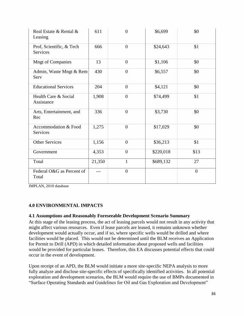
36
Real Estate & Rental &
Leasing
611 0 $6,699 $0
Prof, Scientific, & Tech
Services
666 0 $24,643 $1
Mngt of Companies 13 0 $1,106 $0
Admin, Waste Mngt & Rem
Serv
430 0 $6,557 $0
Educational Services 204 0 $4,121 $0
Health Care & Social
Assistance
1,908 0 $74,499 $1
Arts, Entertainment, and
Rec
336 0 $3,730 $0
Accommodation & Food
Services
1,275 0 $17,029 $0
Other Services 1,156 0 $36,213 $1
Government 4,353 0 $220,018 $13
Total 21,350 1 $689,132 27
Federal O&G as Percent of
Total
--- 0 0
IMPLAN, 2010 database
4.0 ENVIRONMENTAL IMPACTS
4.1 Assumptions and Reasonably Foreseeable Development Scenario Summary
At this stage of the leasing process, the act of leasing parcels would not result in any activity that
might affect various resources. Even if lease parcels are leased, it remains unknown whether
development would actually occur, and if so, where specific wells would be drilled and where
facilities would be placed. This would not be determined until the BLM receives an Application
for Permit to Drill (APD) in which detailed information about proposed wells and facilities
would be provided for particular leases. Therefore, this EA discusses potential effects that could
occur in the event of development.
Upon receipt of an APD, the BLM would initiate a more site-specific NEPA analysis to more
fully analyze and disclose site-specific effects of specifically identified activities. In all potential
exploration and development scenarios, the BLM would require the use of BMPs documented in
“Surface Operating Standards and Guidelines for Oil and Gas Exploration and Development”
37
(USDI and USDA 2007), also known as the “Gold Book.” The BLM could also identify APD
COAs, based on site-specific analysis that could include moving the well location, restrict timing
of the project, or require other reasonable measures to minimize adverse impacts (43 CFR
3101.1-2 Surface use rights; Lease Form 3100-11, Section 6) to protect sensitive resources, and
to ensure compliance with laws, regulations, and land use plans.
For split-state leases, the BLM would notify the private landowners that oil and gas exploration
or development activities are proposed on their lands and they are encouraged to attend the
onsite inspection to discuss the proposed activities. In the event of activity on such split estate
leases, the lessee and/or operator would be responsible for adhering to BLM requirements as
well as reaching an agreement with the private surface landowners regarding access, surface
disturbance, and reclamation.
This chapter presents the potential environmental, social, and economic effects from the actions
described in each alternative in Chapter 2, as well as potential effects from lease exploration and
development activities. Environmental consequences are discussed below by alternative to the
extent possible at this time for the resources described in Chapter 3. As per NEPA regulations at
40 CFR 1502.14(f), 40 CFR 1502.16(h), and 40 CFR 1508.20, mitigation measures to reduce,
avoid, or minimize potential impacts are identified by resource below. The duration of the
possible effects is analyzed and described as either short-term or long-term. Short-term effects
generally last less than five years and long-term effects generally last more than five years.
4.1.1 Reasonably Foreseeable Development Scenario Summary The following assumptions are from the RFD developed for the HiLine Planning Area (for the
HiLine RMP revision; the HiLine planning area includes the Malta, Glasgow, and Havre Field
Offices). The BLM administers approximately 3,483,000 acres of federal minerals of federal
fluid minerals available for leasing within the HiLine Planning Area. The RFD forecasts the
following level of development in the HiLine Planning Area.
The RFD scenario for the HiLine RMP forecasts up to 6,866 wells in the planning area between
2007 and 2026. Up to 150 of these wells could be coalbed natural gas (CBNG) wells. Of the
6,716 conventional wells, 1,351 wells are located within the boundaries of the Bowdoin Dome
area. In the HiLine planning area, high development potential indicates two to 20 wells per
township. Very low development potential indicates two wells or less per township. All of the
offered parcels are located in ‘very low development potential’ areas.
These well numbers are only an estimate based on historical drilling and mineral resources
present, and may change in the future if new technology is developed or new fields and
formations are discovered.
4.1.2 Alternative A (No Action Alternative)
Under the No Action Alternative, the proposed parcels would not be leased. There would be no
new impacts from oil and gas production on the parcel lands. No additional natural gas or crude
oil would enter the public markets, and no royalties would accrue to the federal or state
treasuries. The No Action Alternative would result in the continuation of the current land and
resource uses on the parcels.
38
Unless specifically indicated by resource area, no further analysis of the No Action Alternative is
presented in the following sections.
4.1.3 Analysis Assumptions for Alternative B By itself, the act of leasing the parcels would have no impact on any natural resources in the area
administered by the Glasgow Field Office. Standard terms and conditions as well as special
stipulations would apply to the lease parcels. All impacts would link to as yet undetermined
future levels of lease development.
If the lease parcels are developed, short-term impacts would be stabilized or mitigated rapidly
(within two to five years). Long-term impacts are those that would substantially remain for more
than five years.
4.1.4 Alternative A (No Action Alternative)
4.1.5 Direct Effects Common to All Resources (not including Economics)
Under Alternative A, the 4 parcels would not be offered for competitive oil and gas lease sale.
Under this alternative, the state and private minerals could still be leased in surrounding areas.
There would be no new impacts from oil and gas exploration or production activities on the
federal lease parcel lands. No additional natural gas or crude oil would enter the public markets,
and no royalties would accrue to the federal or state treasuries from the parcel lands. The No
Action Alternative would result in the continuation of the current land and resource uses on the
lease parcels.
Except for Economic resources, described below, no further analysis of the No Action
Alternative is presented.
4.2 Economics
Alternative A
Economic effects are summarized and displayed in comparative form in Table 8 (Current
Contributions of Federal Oil and Gas leasing, Exploration, Development, and Production to the
Local Economy), Table 9 (Summary Comparison of Cumulative Economic Impacts) and Table
10 (Employment and Income Related to BLM Oil and Gas Management). With Alternative A
none of the parcels considered would be leased. Consequently, no additional federal, state, or
local revenues would be generated from leasing, rents, or royalties associated with production.
No additional employment or income would be generated if none of the parcels are leased.
Cumulative Effects
Cumulative economic impacts associated with Alternative A would be similar to those described
in the economic section of the Affected Environment. The cumulative effects of federal mineral
leasing, exploration, development and production within the local economy are summarized in
Table 9 and Table 10. The cumulative demographic and economic characteristics of the local
economy would not change if the parcels being considered are not leased.

39
Table 9. Summary Comparison of Cumulative Annual Economic Impacts by Alternative
Activity
Alternative
A B
Existing Acres leased* 53,285 53,285
Acres that would be leased based on this EA 0 880
Total acres leased 53,285 54,165
Acres held by production* 26,025 26,025
Total acres leased for which lease rents would be
paid 27,260 28,140
Total average annual federal lease and rental
revenue $58,362 $60,078
Average annual distribution to State/local
government $25,656 $26,410
Average annual oil production (bbl)** 0 0
Average annual gas production (MCF)** 336,689 342,249
Total Average annual federal O&G royalties $336,689 $342,249
Average annual distribution to State/local
government $137,504
$139,775
Total average annual federal Revenues $395,051 $402,327
Total average annual State/Local Revenues $163,160 $166,185
Total average annual revenue distributed to
counties $65,519 $66,726
*LR2000, BLM, March 11, 2013
**Based on average annual production 2009-2010, Office of Natural Resource Revenue, 2011
Table 10. Employment and income Related to BLM Oil and Gas Management
Industry Total Jobs Contributed Total Income Contributed ($1000)
Alt. A Alt. B Alt. A Alt. B
Total Federal
Contribution 1 1 $27 $27
Percent Change from
Current -- 1.9% -- 1.9% IMPLAN, 2010 database
Alternative B
Public Revenues
Leasing an additional 880 acres of federal minerals (Alternative B) would increase estimated
average annual oil and gas leasing and rent revenues to the federal government by less than
$2,000. Average annual leasing and rent revenues that would be distributed to state/local
governments would increase by less than $1,000. Estimated average annual federal oil and gas
40
royalties would increase by about $6,000 with Alternative B compared to current levels.
Estimated average annual royalties distributed to the state/county would increase by about
$2,000 compared to current levels.
Total average annual federal revenues related to leasing an additional 880 acres of federal
minerals and associated annual rent and royalty revenues related to average annual production of
federal minerals would amount to about $7,000. Estimated total average annual revenues from
leasing, rent, and royalties distributed to the state and county would increase by about $3,000.
Total estimated annual revenues distributed to Valley County would be about $1,000.
Local Economic Contribution
The estimated combined total average annual employment and income supported by federal oil
and gas leasing, distributions of royalties to local governments, drilling wells, and production
would continue to amount to about one job and $27,000 in labor income within the local
economy (IMPLAN 2010). There would also be no change in local population or households.
Conclusion
Total federal contribution of Alternative B (leasing an additional 880 acres of federal minerals)
and anticipated related exploration, development, and production of oil and gas would have little
affect local income, total local employment, local population, and number of households.
Leasing the additional 880 acres and anticipated exploration, development, and production under
alternative C would provide a small amount of additional funds for Valley County government
functions such as enforcing laws, administering justice, collecting and disbursing tax funds,
providing for orderly elections, maintaining roads and highways, providing fire protection,
keeping records, administering primary and secondary education and operating clinics/hospitals,
county libraries, county airports, local landfills, and county health systems. At the same time,
demand for these services would likely increase very little since the population and number of
households would not change. Leasing the additional 880 acres and anticipated exploration,
development, and production would not change local economic diversity (as indicated by the
number of economic sectors), economic dependency (where one or a few industries dominate the
economy), or economic stability (as indicated by seasonal unemployment, sporadic population
changes and fluctuating income rates) within the local economy.
Disclosure of the direct, indirect, and cumulative effects of GHG emissions provides information
on the potential economic effects of climate change including effects that could be termed the
“social cost of carbon” (SCC). The EPA and other federal agencies developed a method for
estimating the SCC and a range of estimated values (EPA 2013b). The SCC estimates damages
associated with climate change impacts to net agricultural productivity, human health, property
damage, and ecosystems. Using a 3 percent average discount rate and year 2020 values, the
incremental SCC is estimated to be $46 per metric ton of annual CO2e increase. Based on the
GHG emission estimate provided in Section 4.3.3.1.2, the annual SCC associated with potential
development on lease sale parcels is $1,242 (in 2011 dollars). Estimated SCC is not directly
comparable to economic contributions reported above, which recognize certain economic
contributions to the local area and governmental agencies but do not include all contributions to
private entities at the regional and national scale. Direct comparison of SCC to the economic
contributions reported above is also not appropriate because costs associated with climate change
are borne by many different entities.

41
Cumulative Effects
The cumulative effects of federal mineral leasing within the local economy as well as the
specific effects of leasing an additional 880 acres under Alternative C are summarized in Tables
Econ3 (Summary Comparison of Cumulative Annual Economic Impacts by Alternative) and
Econ 4 (Employment and Income Related to BLM Oil and Gas Management).
4.3 Air Resources
4.3.1 Direct and Indirect Effects
4.3.1.1 Air Quality
Leasing the parcels would have no direct impacts on air quality. Any potential effects on air
quality from sale of lease parcels would occur at the time the leases are developed.
Potential impacts of development could include increased airborne soil particles blown from new
well pads or roads; exhaust emissions from drilling equipment, compressors, vehicles, and
dehydration and separation facilities, as well as potential releases of GHGs and VOCs during
drilling or production activities. The amount of increased emissions cannot be precisely
quantified at this time since it is not known for certain how many wells might be drilled, the
types of equipment needed if a well were to be completed successfully (e.g., compressor,
separator, dehydrator), or what technologies may be employed by a given company for drilling
any new wells. The degree of impact would also vary according to the characteristics of the
geologic formations from which production occurs, as well as the scope of specific activities
proposed in an APD.
Current monitoring data show that the criteria pollutant concentrations are well below applicable
air quality standards indicating very good air quality. The potential level of development and
mitigation described below is expected to maintain this level of air quality by limiting emissions.
In addition, pollutants would be regulated through the use of state-issued air quality permits or
air quality registration processes developed to maintain air quality below applicable standards.
4.3.1.2 Greenhouse Gas Emissions at the Analysis Area and Project Scales
Sources of GHGs associated with development of lease parcels may include construction
activities, operations, and facility maintenance in the course of oil and gas exploration,
development, and production. Estimated GHG emissions are discussed for these specific aspects
of oil and gas activity because the BLM has direct involvement in these steps. However, the
current proposed activity is to offer parcels for lease. No specific development activities are
currently proposed or potentially being decided upon for any parcels being considered in this
EA. Potential development activities would be analyzed in a separate NEPA analysis effort if
the BLM receives an APD on any of the parcels considered here.
Anticipated GHG emissions presented in this section are taken from the Climate Change SIR,
2010. Data are derived from emissions calculators developed by air quality specialists at the
BLM National Operations Center in Denver, Colorado, based on methods described in the
Climate Change SIR (2010). Based on the assumptions summarized above for the HiLine RFD

42
(which includes the GFO), Table 11 discloses projected annual GHG source emissions from
BLM-permitted activities associated with the RFD.
Table 11. BLM projected annual emissions of greenhouse gases associated with oil and gas
exploration and development activity in the HiLine.
Source
BLM Long-Term Greenhouse Gas Emissions in tons/year
Emissions (metric tons/yr)
CO2 CH4 N2O CO2e
Conventional Natural Gas
120,756 1041 0.87 129,664
Coal Bed
Natural Gas
884 48 0.00 1,725
Oil 2,380 16 0.01 2,467
Total 124,020 1,105 0.88 133,856
To estimate GHG emissions associated with the action alternatives, the following approach was
used:
1. The proportion of each project level action alternative relative to the total RFD was
calculated based on total acreage of parcels under consideration for leasing relative to the
total acreage of federal mineral acreage available for leasing in the RFD.
2. This ratio was then used as a multiplier with the total estimated GHG emissions for the
entire RFD (with the highest year emission output used) to estimate GHG emissions for
that particular alternative.
Under Alternative B, approximately 880.15 acres of lease parcels with federal minerals would be
leased. These acres constitute approximately 0.020 percent of the total federal mineral estate of
approximately 4,307,538 acres identified in the HiLine RFD. Therefore, based on the approach
described above to estimate GHG emissions, 0.020 percent of the RFD for this EA would be
approximately 27 metric tons/year of CO2e if the parcels within Alternative B were to be
developed (based on 133,856 metric tons/year for full RFD).
4.3.1.3 Climate Change
The assessment of GHG emissions and climate change is in its formative phase. As summarized
in the Climate Change SIR, climate change impacts can be predicted with much more certainty
over global or continental scales. Existing models have difficulty reliably simulating and
attributing observed temperature changes at small scales. On smaller scales, natural climate
variability is relatively larger, making it harder to distinguish changes expected due to external
forcings (such as contributions from local activities to GHGs). Uncertainties in local forcings
and feedbacks also make it difficult to estimate the contribution of GHG increases to observed
small-scale temperature changes (Climate Change SIR 2010).

43
It is currently not possible to know with certainty the net impacts from lease parcel development
on climate. The inconsistency in results of scientific models used to predict climate change at
the global scale coupled with the lack of scientific models designed to predict climate change on
regional or local scales, limits the ability to quantify potential future impacts of decisions made
at this level. It is therefore beyond the scope of existing science to relate a specific source of
GHG emission or sequestration with the creation or mitigation of any specific climate-related
environmental effects. Although the effects of GHG emissions in the global aggregate are well-
documented, it is currently impossible to determine what specific effect GHG emissions
resulting from a particular activity might have on the environment. For additional information
on environmental effects typically attributed to climate change, please refer to the cumulative
effects discussion below.
While it is not possible to predict effects on climate change of potential GHG emissions
discussed above in the event of lease parcel development for alternatives considered in this EA,
the act of leasing does not produce any GHG emissions in and of itself. Releases of GHGs
would occur during exploration, development, and production.
4.3.2 Mitigation
The BLM encourages industry to incorporate and implement BMPs to reduce impacts to air
quality by reducing emissions, surface disturbances, and dust from field production and
operations. Measures may also be required as COAs on permits by either the BLM or the
applicable state air quality regulatory agency. The BLM also manages venting and flaring of gas
from federal wells as described in the provisions of Notice to Lessees (NTL) 4A, Royalty or
Compensation for Oil and Gas Lost.
Some of the following measures could be imposed at the development stage:
flare or incinerate hydrocarbon gases at high temperatures to reduce emissions of
incomplete combustion;
install emission control equipment of a minimum 95 percent efficiency on all condensate
storage batteries;
install emission control equipment of a minimum 95 percent efficiency on dehydration
units, pneumatic pumps, produced water tanks;
vapor recovery systems where petroleum liquids are stored;
tier II or greater, natural gas or electric drill rig engines;
secondary controls on drill rig engines;
no-bleed pneumatic controllers (most effective and cost effective technologies available
for reducing volatile organic compounds (VOCs));
gas or electric turbines rather than internal combustions engines for compressors;
nitrogen oxides (NOx) emission controls for all new and replaced internal combustion oil
and gas field engines;
water dirt and gravel roads during periods of high use and control speed limits to reduce
fugitive dust emissions;
interim reclamation to re-vegetate areas of the pad not required for production facilities
and to reduce the amount of dust from the pads.
co-locate wells and production facilities to reduce new surface disturbance;

44
directional drilling and horizontal completion technologies whereby one well provides
access to petroleum resources that would normally require the drilling of several vertical
wellbores;
gas-fired or electrified pump jack engines;
install velocity tubing strings;
cleaner technologies on completion activities (i.e. green completions), and other ancillary
sources;
centralized tank batteries and multi-phase gathering systems to reduce truck traffic;
forward looking infrared (FLIR) technology to detect fugitive emissions; and
air monitoring for NOx and ozone (O3).
More specific to reducing GHG emissions, Section 6 of the Climate Change SIR identifies and
describes in detail commonly used technologies to reduce methane emissions from natural gas,
coal bed natural gas, and oil production operations. Technologies discussed in the Climate
Change SIR and as summarized below in Table 14 (reproduced from Table 6-2 in Climate
Change SIR), display common methane emission technologies reported under the USEPA
Natural Gas STAR Program and associated emission reduction, cost, maintenance and payback
data.
Table 12. Selected Methane Emission Reductions Reported Under the USEPA Natural
Gas STAR Program1
Source Type / Technology
Annual
Methane
Emission
Reduction 1
(Mcf/yr)
Capital Cost
Including
Installation
($)
Annual
Operating and
Maintenance
Cost
($)
Payback
(Years or
Months)
Payback
Gas Price
Basis
($/Mcf)
Wells
Reduced emission (green)
completion
7,000 2 $1K – $10K >$1,000 1 – 3 yr $3
Plunger lift systems 630 $2.6K – $10K NR 2 – 14 mo $7
Gas well smart automation
system
1,000 $1.2K $0.1K – $1K 1 – 3 yr $3
Gas well foaming 2,520 >$10K $0.1K – $1K 3 – 10 yr NR
Tanks
Vapor recovery units on crude
oil tanks
4,900 –
96,000
$35K – $104K $7K – $17K 3 – 19 mo $7
Consolidate crude oil
production and water storage
tanks
4,200 >$10K <$0.1K 1 – 3 yr NR
Glycol Dehydrators
Flash tank separators 237 – 10,643 $5K – $9.8K Negligible 4 – 51 mo $7
Reducing glycol circulation
rate
394 – 39,420 Negligible Negligible Immediate $7
Zero-emission dehydrators 31,400 >$10K >$1K 0 – 1 yr NR

45
Table 12. Selected Methane Emission Reductions Reported Under the USEPA Natural
Gas STAR Program1
Source Type / Technology
Annual
Methane
Emission
Reduction 1
(Mcf/yr)
Capital Cost
Including
Installation
($)
Annual
Operating and
Maintenance
Cost
($)
Payback
(Years or
Months)
Payback
Gas Price
Basis
($/Mcf)
Pneumatic Devices and
Controls
Replace high-bleed devices
with low-bleed devices
End-of-life replacement 50 – 200 $0.2K – $0.3K Negligible 3 – 8 mo $7
Early replacement 260 $1.9K Negligible 13 mo $7
Retrofit 230 $0.7K Negligible 6 mo $7
Maintenance 45 – 260 Negl. to $0.5K Negligible 0 – 4 mo $7
Convert to instrument air 20,000 (per
facility)
$60K Negligible 6 mo $7
Convert to mechanical control
systems
500 <$1K <$0.1K 0 – 1 yr NR
Valves
Test and repair pressure safety
valves
170 NR $0.1K – $1K 3 – 10 yr NR
Inspect and repair compressor
station blowdown valves
2,000 <$1K $0.1K – $1K 0 – 1 yr NR
Compressors
Install electric compressors 40 – 16,000 >$10K >$1K >10 yr NR
Replace centrifugal
compressor wet seals with dry
seals
45,120 $324K Negligible 10 mo $7
Flare Installation 2,000 >$10K >$1K None NR Source: Multiple USEPA Natural Gas STAR Program documents. Individual documents are referenced in Climate Change
SIR (2010). 1 Unless otherwise noted, emission reductions are given on a per-device basis (e.g., per well, per dehydrator, per valve, etc). 2 Emission reduction is per completion, rather than per year.
K = 1,000
mo = months
Mcf = thousand cubic feet of methane
NR = not reported
yr = year
In the context of the oil sector, additional mitigation measures to reduce GHG emissions include
methane reinjection and CO2 injection. These measures are discussed in more detail in Section
6.0 of the Climate Change SIR (2010).
In an effort to disclose potential future GHG emissions reductions that might be feasible in
individual field offices, the BLM estimated GHG emissions reductions based on the RFD for the
Miles City Field Office (MCFO). For analysis purposes, the Miles City FO RFD was selected
based on the high potential development scenario. Similar emissions reductions may be possible
in the HiLine analysis area. For emissions sources subject to BLM (federal) jurisdiction, the
estimated emissions reduction represent approximately 51 percent reduction in total GHG
emissions compared to the estimated MCFO federal GHG emissions inventory (Climate Change
SIR, as updated October 2010, Section 6.5 and Table 6-3). The emissions reduction
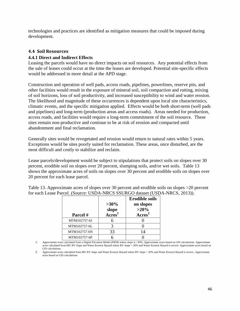
46
technologies and practices are identified as mitigation measures that could be imposed during
development.
4.4 Soil Resources
4.4.1 Direct and Indirect Effects
Leasing the parcels would have no direct impacts on soil resources. Any potential effects from
the sale of leases could occur at the time the leases are developed. Potential site-specific effects
would be addressed in more detail at the APD stage.
Construction and operation of well pads, access roads, pipelines, powerlines, reserve pits, and
other facilities would result in the exposure of mineral soil, soil compaction and rutting, mixing
of soil horizons, loss of soil productivity, and increased susceptibility to wind and water erosion.
The likelihood and magnitude of these occurrences is dependent upon local site characteristics,
climatic events, and the specific mitigation applied. Effects would be both short-term (well pads
and pipelines) and long-term (production areas and access roads). Areas needed for production,
access roads, and facilities would require a long-term commitment of the soil resource. These
sites remain non-productive and continue to be at risk of erosion and compacted until
abandonment and final reclamation.
Generally sites would be revegetated and erosion would return to natural rates within 5 years.
Exceptions would be sites poorly suited for reclamation. These areas, once disturbed, are the
most difficult and costly to stabilize and reclaim.
Lease parcels/development would be subject to stipulations that protect soils on slopes over 30
percent, erodible soil on slopes over 20 percent, slumping soils, and/or wet soils. Table 13
shows the approximate acres of soils on slopes over 30 percent and erodible soils on slopes over
20 percent for each lease parcel.
Table 13. Approximate acres of slopes over 30 percent and erodible soils on slopes >20 percent
for each Lease Parcel. (Source: USDA-NRCS SSURGO dataset (USDA-NRCS, 2013)).
Parcel #
>30%
slope
Acres1
Erodible soils
on slopes
>20%
Acres2
MTM102757-6J 6 0 MTM102757-6L 3 0 MTM102757-6N 33 14 MTM102757-6P 6 0
1. Approximate acres calculated from a Digital Elevation Model (DEM) where slope is >30%. Approximate acres based on GIS calculations. Approximate
acres calculated from MU RV slope and Water Erosion Hazard where RV slope > 20% and Water Erosion Hazard is severe. Approximate acres based on
GIS calculations.
2. Approximate acres calculated from MU RV slope and Water Erosion Hazard where RV slope > 20% and Water Erosion Hazard is severe. Approximate
acres based on GIS calculations.

47
4.4.2 Mitigation
In the event of exploration/development, a number of measures would be taken to prevent,
minimize, or mitigate effects to soil resources. Prior to authorization, proposed actions would be
evaluated on a case-by-case basis and would be subject to mitigation measures in order to
maintain the soil system. Typical measures include, but are not limited to:
• Avoiding areas poorly suited to reclamation;
• Requiring special reclamation of the prime farmlands, if irrigated, to ensure there is no
unnecessary and irreversible conversion of prime farmland to nonagricultural uses;
• Limiting the total area of disturbance;
• Stripping and stockpiling topsoil separate from sub-soils/spoil;
• Applying erosion/sediment control/containment products and structures, such as mulch,
straw wattles, water bars, rolling dips, silt fence, bale filters, erosion control blankets and
mats, cover crops, etc.;
• Alleviating compaction;
• Applying soil amendments, when necessary;
• Re-contouring to approximate original contours or blend with surrounding topography;
• Re-seeding with desired vegetation;
• Completing interim reclamation on all disturbed areas associated with producing well
locations and associated facilities; and,
• Monitoring for reclamation success and applying additional measures as needed.
Measures included in the Gold Book (USDI-BLM 2007) would be applied. Additional
mitigation measures and/or BMPs, if necessary, would be applied once a site-specific plan of
development is proposed.
Upon abandonment of wells and/or when access roads are no longer needed, the authorized
officer would issue instructions and/or orders for surface reclamation/restoration of the disturbed
areas as described in attached conditions of approval (COA).
4.5 Water Resources
4.5.1 Direct and Indirect Effects
Leasing the parcels would not directly affect water resources. Any potential effects on water
resources from the sale of lease parcels would occur at the time the leases are developed. The
magnitude of the effects on water resources would be dependent on the specific activity, season,
proximity to waterbodies, location in the watershed, upland and riparian vegetation condition,
effectiveness of mitigation, and the time until reclamation success. Surface disturbance effects
typically are localized, short-term, and occur from implementation through vegetation
reestablishment. As acres of surface-disturbance increase within a watershed, so could the
effects on water resources.
In uplands within the watershed and in floodplains of non-riparian and ephemeral waterbodies,
oil and gas exploration and development of a lease parcel could cause the removal of vegetation,
soil compaction, and soil disturbance. The potential effects from these activities could be
accelerated erosion, increased overland flow, decreased infiltration, increased water temperature,
channelization, and water quality degradation associated with increased sedimentation, turbidity,

48
nutrients, metals, and other pollutants. Erosion potential can be further increased in the long
term by soil compaction and low permeability surfacing (e.g., roads and well pads) which
increases the energy and amount of overland flow and decreases infiltration, which in turn
changes flow characteristics, reduces groundwater recharge, and increases sedimentation and
erosion (DEQ 2007).
Spills or produced fluids could potentially impact surface and groundwater resources in the long
term. Oil and gas exploration and development of a lease parcel could contaminate aquifers
with salts, drilling fluids, fluids and gases from other formations, detergents, solvents,
hydrocarbons, metals, and nutrients; change vertical and horizontal aquifer permeability; and
increase hydrologic communication with adjacent aquifers (EPA 2004). Groundwater removal
could result in a depletion of flow in nearby streams and springs if the aquifer is hydraulically
connected to such features. Produced water from conventional oil and gas wells is typically from
a depth below useable aquifers or coal seams.
Ground Water: The eventual drilling of the proposed parcels would most likely pass through
useable groundwater. Potential impacts to groundwater resources could occur if proper
cementing and casing programs are not followed. This could include loss of well integrity,
surface spills, or loss of fluids in the drilling and completion process. It is possible for chemical
additives used in drilling activities to be introduced into the water producing formations without
proper casing and cementing of the well bore. Changes in porosity or other properties of the rock
being drilled through can result in the loss of drilling fluids. When this occurs, drilling fluids can
be introduced into groundwater without proper cementing and casing. Site specific conditions
and drilling practices determine the probability of this occurrence and determine the groundwater
resources that could be impacted. In addition to changing the producing formations’ physical
properties by increasing the flow of water, gas, and/or oil around the well bore; hydraulic
fracturing can also introduce chemical additives into the producing formations. Types of
chemical additives used in drilling activities may include acids, hydrocarbons, thickening agents,
lubricants, and other additives that are operator and location specific. These additives are not
always used in these drilling activities and some are likely to be benign such as bentonite clay
and sand. Concentrations of these additives also vary considerably since different mixtures can
be used for different purposes in oil and gas development and even in the same well bore. If
contamination of aquifers from any source occurs, changes in groundwater quality could impact
springs and residential wells that are sourced from the affected aquifers. Onshore Order #2
requires that the proposed casing and cementing programs shall be conducted as approved to
protect and/or isolate all usable water zones.
Known water bearing zones in the lease area are protected by drilling requirements and, with
proper practices, contamination of ground water resources is highly unlikely. Casing along with
cement is extended well beyond fresh-water zones to insure that drilling fluids remain within the
well bore and do not enter groundwater.
Potential impacts to ground water at site specific locations are analyzed through the NEPA
review process at the development stage when the APD is submitted. This process includes

49
geologic and engineering reviews to ensure that cementing and casing programs are adequate to
protect all downhole resources.
All water used would have to comply with Montana state water rights regulations and a source of
water would need to be secured by industry that would not harm senior water rights holders.
4.5.2 Mitigation
Stipulations addressing steep slopes, waterbodies, streams, riparian areas, and wetlands would
minimize potential impacts and would be included with the lease when necessary. In the event
of exploration or development, measures would be taken to reduce, avoid, or minimize potential
impacts to water resources including application of appropriate mitigation. Mitigation measures
that minimize the total area of disturbance, control wind and water erosion, reduce soil
compaction, maintain vegetative cover, control nonnative species, and expedite rapid
reclamation (including interim reclamation) would maintain water resources. Methods to reduce
erosion and sedimentation could include: reducing surface disturbance acres; installing and
maintaining adequate erosion control; proper road design, road surfacing, and culvert design;
road and infrastructure maintenance; use of low water crossings; and use of horizontal
directional drilling methods for waterbodies and floodplains. In addition, applying mitigation to
maintain adequate, undisturbed, vegetated buffer zones around waterbodies and floodplains
could reduce sedimentation and maintain water quality. Appropriate well completion, the use of
Spill Prevention Plans, and Underground Injection Control regulations would assist with
mitigation of groundwater impacts. Site-specific mitigation and reclamation measures would be
described in the Conditions of Approval in the Application for Permit to Drill.
4.6 Vegetation Resources
4.6.1 Direct and Indirect Effects
Leasing the parcels would have no direct impacts on vegetation resources. Any potential effects
on vegetation resources from sale of lease parcels would occur at the time the leases are
developed. Impacts to vegetation would depend on the vegetation type/community, soil
community and the topography of the lease parcels. Disturbance to vegetation is of concern
because protection of soil resources, maintenance of water quality, conservation of wildlife
habitat, and livestock production capabilities may be diminished or lost over the long-term
through direct loss of vegetation (including direct loss of both plant communities and specific
plant species).
Other direct impacts, such as invasive species and noxious weed invasion could result in loss of
desirable vegetation. Invasive species and noxious weeds may also reduce livestock grazing
forage, wildlife habitat quality, and native species diversity. Cheatgrass is an invasive species
well known for completely replacing native vegetation and changing fire regimes.
Additionally, surface disturbing activities directly affect vegetation by destroying habitat,
churning soils, impacting biological crusts, disrupting seedbanks, burying individual plants, and
generating sites for competitive non-native plants including weedy species. In addition, other

50
vegetation impacts could also be caused from soil erosion and result in loss of the supporting
substrate for plants, or from soil compaction resulting in reduced germination rates. Impacts to
plants occurring after seed germination but prior to seed set could be particularly harmful as both
current and future generations would be affected.
Fugitive dust generated by construction activities and travel along dirt roads can affect nearby
plants by depressing photosynthesis, disrupting pollination, and reducing reproductive success.
Oil, fuel, wastewater or other chemical spills could contaminate soils as to render them
temporarily unsuitable for plant growth until cleanup measures were fully implemented. If
cleanup measures were less successful, longer term vegetation damage could be expected.
4.6.2 Mitigation
Mitigation would be addressed at the site specific APD stage of exploration and development. If
needed, COAs would potentially include revegetation with desirable plant species, soil
enhancement practices, direct live haul of soil material for seed bank revegetation, reduction of
livestock grazing, fencing of reclaimed areas, and the use of seeding strategies consisting of
native grasses, forbs, and shrubs, would be identified and addressed at the APD stage.
4.7 Riparian-Wetland Habitats
4.7.1 Direct and Indirect Effects Leasing the parcels would have no direct impacts on riparian-wetland habitats. Any potential
effects on riparian-wetland habitats from sale of lease parcels would occur at the time the leases
are developed. The exploration and development of oil and gas within uplands or adjacent to
riparian-wetland areas could reduce riparian/wetland functionality by changing native plant
productivity, composition, richness, and diversity; accelerating erosion; increasing
sedimentation; and changing hydrologic characteristics. Impacts that reduce the functioning
condition of riparian and wetland areas would impair the ability of riparian/wetland areas to
reduce nonpoint source pollution (MDEQ 2007) and provide other ecosystem benefits. The
magnitude of these effects would be dependent on the specific activity, season, proximity to
riparian-wetland areas, location in the watershed, upland and riparian-wetland vegetation
condition, mitigation applied, and the time until reclamation success. Erosion increases typically
are localized, short term, and occur from implementation through vegetation reestablishment. As
acres of surface-disturbance increase within a watershed, so would the effects on riparian-
wetland resources.
4.7.2 Mitigation Stipulations addressing steep slopes, waterbodies, and streams, 100-year floodplains of major
rivers, riparian areas, and wetlands would minimize potential impacts and would be included
with the lease when necessary (refer to Appendix A). In the event of exploration or
development, site-specific mitigation measures would be identified which would avoid or
minimize potential impacts to riparian-wetland areas at the APD stage. Mitigation measures that
minimize the total area of disturbance, control wind and water erosion, reduce soil compaction,
maintain vegetative cover, control nonnative species, maintain biodiversity, maintain vegetated
buffer zones, and expedite rapid reclamation (including interim reclamation) would maintain
riparian/wetland resources.

51
4.8 Wildlife
4.8.1 Direct and Indirect Effects Leasing the parcels would have no direct impacts on wildlife. Any potential effects on wildlife
from sale of lease parcels would occur at the time the leases are developed.
The use of standard lease terms and stipulations on these lands (refer to Appendix A) would
minimize, but not preclude impacts to wildlife. Oil and gas development which results in surface
disturbance could directly and indirectly impact aquatic and terrestrial wildlife species. These
impacts could include loss or reduction in suitability of habitat, improved habitat for undesirable
(non-native) competitors, species or community shift to species or communities more tolerant of
disturbances, nest abandonment, mortalities resulting from collisions with vehicles and power
lines, electrocutions from power lines, barriers to species migration, habitat fragmentation,
increased predation, habitat avoidance, and displacement of wildlife species resulting from
human presence. The scale, location, and pace of development, combined with implementation
of mitigation measures and the specific tolerance of the species to human disturbance all
influence the severity of impacts to wildlife species and habitats, including Threatened,
Endangered, Candidate, Proposed, and other special status species.
4.8.1.1 Threatened, Endangered Proposed, and Candidate Species
Habitat within the lease parcels does not exist to support USFWS Threatened, Endangered,
Proposed, or Candidate species including the whooping crane, interior least tern, piping plover,
black-footed ferret, pallid sturgeon, Greater Sage-Grouse.
Sprague’s pipit habitat is considered moderate within the nominated parcels. However, the
parcels are split estate ownership and agriculture is the dominant land use within the nominated
parcels. Standard stipulations would be able to further minimize potential effects to Sprague’s
pipit and potential development would most likely occur on currently disturbed lands. Potential
development of the offered tracts would not be expected to affect the population or listing status.
Potential site specific effects would be addressed in more detail at the APD stage.
Therefore, if development of these leases is proposed, BLM would consult with the USFWS
pursuant to section 7(a) (2) of ESA. An outcome of the consultation process may be that
conditions of approval are attached to the permit or the permit may not be approved. Other
BMP’s would also be developed through consultation, including minimizing disturbance,
adherence to Avian Powerline Interaction Committee (APLIC) guidelines, and others as deemed
appropriate.
4.8.1.2 Other Special Status Species
As noted, up to 46 wildlife species that BLM has designated as “sensitive” have the potential to
occur within the parcel areas. Stipulations are not provided for all BLM sensitive species in the
current Resource Management Plans. Impacts to BLM sensitive species would be similar to
those described above, unless they are afforded protective measures from other regulations such
as the Migratory Bird Treaty Act (MBTA) (16 U.S.C. 703.) BLM does not consult with the
USFWS on “sensitive” species and likewise would not receive terms and conditions from
USFWS requiring additional protections of those species.

52
Stipulations do not exist specifically for the protection of BLM sensitive songbirds. The MBTA
prohibits the take, capture or kill of any migratory bird, any part, nest or eggs of any such bird
(16 U.S.C 703 (a)). NEPA analysis pursuant to Executive Order 13186 (January 2001) requires
BLM to ensure that MBTA compliance and the effects of Bureau actions and agency plans on
migratory birds are evaluated, should reduce take of migratory birds and contribute to their
conservation.
Effects to migratory birds from oil and gas development at the APD stage could include direct
loss of habitat from roads, well pads and other infrastructure, disturbance, powerline strikes and
accidental direct mortality, fragmentation of habitat, change in use of habitats, and potential
threats and competition from edge species. Field surveys for nesting birds at proposed
development sites would be conducted for activities planned between May 1 and August 30.
Mitigation measures would be assigned at the APD stage to ensure there would be no measurable
negative effect on migratory bird populations, in compliance with Executive Order 13186 and
MBTA. These mitigation measures would be required as Conditions of Approval. An NSO
stipulation for oil and gas surface disturbing activities in riparian and wetland areas would
prohibit any potential oil and gas development in those habitats unless approval was granted
through the “Waivers, Exceptions, and Modifications” (WEM) process. BLM would coordinate
WEMs with USFWS to assure MBTA compliance.
4.8.1.3 Other Fish and Wildlife
The types and extent of impacts to wildlife species and habitats from development are similar to
those described above for other species. Impacts include loss of habitat from development
infrastructure, mortalities resulting from collisions with vehicles and power lines, electrocution
on power lines, and displacement of wildlife species from initial disturbance caused by human
presence. Indirect impacts would include habitat fragmentation and subsequent vehicle traffic,
human presence, and other continual development activities.
Based on the RFD scenarios, a wide range of direct habitat loss is possible. Initial disturbance
would change the occupation of those areas to disturbance-oriented species (i.e. horned larks), or
species with more tolerance for disturbances. These changes would also be expected to decrease
the diversity of wildlife. Although bladed corridors would be reclaimed after the facilities are
constructed, some changes in vegetation would occur along the reclaimed areas. The goal of
reclamation is to restore disturbed areas to pre-disturbed conditions. The outcome of
reclamation, unlike site restoration, will therefore not always mimic pre-disturbance conditions
and offer the same habitat values to wildlife species. Sagebrush obligates, including some
species of songbirds and sage grouse, would be most affected by this change.
It is anticipated that some development may occur adjacent to existing disturbances of some
type. Depending on proximity and species tolerance, wildlife species within these areas would
either have acclimated to the surrounding conditions, previously been displaced by construction
activities, or may be caused to be displaced to other areas with or without preferred habitat.
Although there are no fish bearing streams within the proposed parcels, there are several
drainages that contain water during spring runoff. Potential impacts to aquatic wildlife from
53
development could include: overland oil spills, underground spills from activities associated with
horizontal drilling or other practices, spills from drilling mud or other extraction and processing
chemicals, and surface disturbance activities that create a localized erosion zone. Oil spills and
other pollutants from the oil extraction process could harm the aquatic wildlife species in two
different ways if the spill substances enter the habitat. First, toxicological impacts from direct
contact could have immediate lethal effects to eggs, larvae, juveniles, and adults. Second, toxic
effects to lower food web levels (e.g. aquatic macro-invertebrates) would indirectly affect fish,
amphibian, and reptile species by degrading water quality and degrading or eliminating food
resources.
Additional mitigation will occur as conditions of approval at the APD stage. These conditions
might include the placement of earthen berms and oil skimmers (in ephemeral drainages where
fish passage will not be blocked) which should help protect aquatic wildlife habitat in case of oil
spills.
4.8.2 Mitigation
Measures would be taken to prevent, minimize, or mitigate impacts to fish and wildlife animal
species from exploration and development activities. Prior to authorization, activities would be
evaluated on a case-by-case basis, and the project would be subject to mitigation measures.
Mitigation could include rapid revegetation, project relocation, or pre-disturbance wildlife
species surveying. If oil and gas development is proposed in suitable habitat for threatened or
endangered species, consultation with the USFWS would occur to determine if additional terms
and conditions would need to be applied.
4.9 Special Status Plant Species
4.9.1 Direct and Indirect Effects
Leasing the parcels would have no direct impacts on special status plant species. Any potential
effects from the sale of leases would occur at the time the leases are developed.
4.9.2 Mitigation
Stipulations applied to wildlife resources, steep slopes, waterbodies, streams, 100-year
floodplains of major rivers, riparian areas, and wetlands would likely also provide protections for
special status plant species. Proposed development would be analyzed on a site-specific basis
prior to approval of oil and gas exploration or development activities at the APD stage.
Mitigation would also be addressed at the site-specific APD stage. Surveys to determine the
existence of federally listed species could occur on BLM-administered surface or minerals prior
to approval of exploration and development activities at the APD stage.
4.10 Cultural Resources
4.10.1 Direct and Indirect Effects
Leasing a nominated parcel gives a basic right to the operator to develop the lease in accordance
with any stipulations incorporated into the terms of the lease for the protection of resource
values. However, it is during surface disturbing activities associated with the proposed
development of the lease that there is a potential for cultural resources to be affected by the
proposed action. It is only when the decision is made to develop the lease that drilling locations
54
are known and cultural resource investigations can be completed for the proposed development
and any other ancillary activities such as roads, transmission lines, and pipelines.
When the Application for a Permit to Drill (APD) is received, specific oil and gas development
actions are proposed, the resulting area of potential effect (APE) is defined, and then assessments
of the impacts on cultural resources can be undertaken in order to comply with Section 106 of
the National Historic Preservation Act (NHPA).
A Class III cultural resource inventory will be necessary for those parcels where the proposed
APE has not been previously surveyed and/or for those parcels where the APE has been judged
inadequately surveyed in the past, specifically in this case all identified parcels will require Class
III Inventory as none has been performed in the past with one exception (85-MT-060-1). Lease
Notice 14-5 will apply to all parcels (Appendix A). In the event that cultural resources are
identified within the APE, an evaluation of National Register eligibility will occur for each
identified cultural property. Measures for the protection of cultural resources determined to be
eligible to the National Register of Historic Places (NRHP) will have to be followed for those
cultural resources directly and/or indirectly impacted by the proposed development in
accordance with Lease Notice 16-1 (Appendix A).
Direct and indirect impacts are not anticipated from leasing nominated parcels. It is at the APD
stage of development that specific impacts can be correctly assessed. Potential direct impacts to
cultural resources at the APD stage include damage to archaeological sites through construction
activities (e.g. pad construction, road building, well drilling, etc.). Other effects to cultural
resources from surface disturbance activities include the destruction, damage, or alteration to all
or part of the cultural resource and diminishing the property’s significant historic features as a
result of the introduction of visual, atmospheric, or audible elements. This could include altering
or diminishing the elements of a National Register eligible property and diminish an eligible
property’s eligibility status.
Potential indirect impacts from lease development may include increased erosion resulting from
surface disturbing activities, increased vandalism resulting from improved access to the area,
abrasive dust and vibrations from drilling equipment and damage to rock art sites from gas
emissions. Indirect effects from development activities have the potential to alter the
characteristics of a significant cultural or historic property by diminishing the integrity of the
property's location, design, setting, materials, workmanship, feeling, or association.
Conversely, cultural resource investigations associated with development potentially adds to our
understanding of the prehistory/history of the area under investigation and discovery of sites that
would otherwise remain undiscovered due to lack of inventory or investigation.
Climate change may have an effect on cultural resources by changing the frequency and severity
of natural events, such as heavy rain and wildfires (Agee 1993; Maslin 2004). Heavy rain
increases the likelihood of flooding and soil erosion which could impact an archaeological site
by exposing, removing, and displacing archaeological materials. Wildfires can affect the
morphology of artifacts through fracturing and discoloration which can reduce an artifact’s
ability to render information about the past (Winthrop 2004). Wildfires can also destroy organic

55
materials such as bone, wood, and pollen that provide information about past environments and
subsistence. Furthermore, fire suppression activities (e.g. fire retardant and fire line construction)
and increased artifact exposure from vegetation burn-off, can also have an adverse impact on
archaeological sites.
4.10.2 Mitigation
Under this alternative it is recommended that all lease parcels be leased with cultural resource
Lease Notice 14-5 and 16-1. See Appendix A for specific legal location description and
Appendix B for description of Lease Stipulations. In addition to specific Lease Stipulations to
protect known resource values, additional site specific avoidance and/or mitigation measures,
would have to be determined after project specific development proposals are received and Class
III cultural resource inventories have been completed. In almost all situations, direct impacts to
cultural resources will be avoided by project redesign and/or relocating the surface disturbing
activities (e.g., roads, well pads and pipelines, etc.). Given the overall size of the lease parcel
and the relatively small percentage or number of acres to be disturbed by anticipated
development, avoidance of impacts to significant cultural resources being the primary concern,
it is unlikely that it would be necessary to mitigate adverse impacts to archaeological sites
through data recovery efforts. It should be noted that BLM has discretional control over
mitigation stipulations measures imposed on a project. Although a lessee has a right to develop a
lease, BLM may require development activities to be moved up to 200 meters in any direction.
This should allow nearly all cultural properties to be avoided. Should development uncover
subsurface sites, the lessee is required to halt all work until the site can be evaluated and proper
mitigation measures can be implemented
The use of standard lease terms, the cultural no surface occupancy (NSO) stipulation, and the
cultural lease notice, protect significant cultural resource values on these lease parcels (refer to
Appendix A). The application of these requirements at the leasing phase provide protection to
cultural values or at least notification to the lessee that potentially valuable cultural resource
values are or are likely to be present on the lease parcels.
4.11 Native American Religious Concerns
4.11.1 Direct and Indirect Effects Leasing the parcels would have no direct impacts on Native American religious concerns. Any
potential effects from the sale of leases would occur at the time the leases are developed.
The BLM WO IM-2005-003 notes that while a lease does not authorize specific on-the-ground
activities, and no ground disturbance can occur without further authorization from BLM and the
surface management agency, but unless proscribed by stipulation, lessees can expect to drill
somewhere on a lease unless precluded by law. Leasing would not have an impact on TCPs
and/or areas of religious or cultural importance to tribes. A lease sale would not interfere with
the performance of traditional ceremonies and rituals pursuant to the American Indian Religious
Freedom Act (AIRFA) or EO 13007. It would not prevent tribes from visiting sacred sites or
prevent possession of sacred objects. Indirect effects from site specific development proposals
could have an impact to Native American religious practices and TCPs.

56
4.11.2 Mitigation
Cultural Resources Lease Stipulation 16-1 will apply to all lease parcels (Appendix A). The
application of Stipulation 16-1 to all lease parcels ensures that BLM’s obligations under NHPA,
American Indian Religious Freedom Act, Native American Graves Protection and Repatriation
Act, E.O. 13007, and other statutes as applicable will be met. At the APD stage when specific oil
and gas development actions are proposed, the area of potential effect (APE) will be defined and
federally recognized tribes will be consulted if necessary. Additional Stipulations (NSO or CSU)
may be necessary if TCPs or properties of religious and cultural importance are identified at the
APD stage.
4.12 Paleontology
4.12.1 Direct and Indirect Effects
Leasing the parcels would have no direct impacts on paleontological resources. Any potential
effects from the sale of leases could occur at the time the leases are developed.
Indirect impacts from the sale of leases would be from the surface disturbances associated with
oil and gas exploration and development activities. It is anticipated that most significant fossil
resources are located in those geologic units with a Potential Fossil Yield Classification (PFYC)
of 3 or higher. However, significant fossil resources could be discovered anywhere. Surface-
disturbing activities could potentially alter the characteristics of paleontological resources
through damage, fossil destruction, or disturbance of the stratigraphic context in which
paleontological resources are located, resulting in the loss of important scientific data. Identified
paleontological resources could be avoided by project redesign or relocation before project
approval which would negate the need for the implementation of mitigation measures.
Conversely, surface-disturbing activities could potentially lead to the discovery of
paleontological localities that would otherwise remain undiscovered due to burial or omission
during review inventories. The scientific retrieval and study of these newly discovered resources
would expand our understanding of past life and environments of Montana.
4.12.2 Mitigation
The application of lease terms, the paleontological no surface occupancy stipulation (NSO 11-
12), and the paleontological lease notice (LN 14-12) at leasing, provides protection to
paleontological resources during development. The paleontological lease notice is applied to
those lease parcels that fall within the PFYC 3 or higher geologic units, requiring a field survey
prior to surface disturbance. These inventory requirements could result in the identification of
paleontological resources. Avoidance of significant paleontological resources or implementation
of mitigation prior to surface disturbance would protect paleontological resources. However, the
application of lease terms only allows the relocation of activities up to 200 meters, unless
documented in the NEPA document, and cannot result in moving the activity off lease.
Specific mitigation measures could include, but are not limited to, site avoidance or excavation.
Avoidance of paleontological properties would be a best management practice. However, should
a paleontological locality be unavoidable, significant fossil resources must be mitigated prior to

57
implementation of a project. Also, significant fossil resources could be discovered in areas that
had not been surveyed (PFYC of less than 3) during surface disturbance. Those resources must
also be professionally mitigated. These mitigation measures and contingencies would be
determined when site specific development proposals are received.
In order to protect paleontological resources, the 4 parcels are recommended to have the
Paleontological lease notice 14-12 applied per guidance identified in IM 2009-011 and 2008-
009. No parcels are recommended for the no surface occupancy lease stipulation (NSO 11-12)
based upon paleontological resources. See section 3.10 Paleontology for list of parcels.
4.13 Visual Resources
4.13.1 Direct and Indirect Effects
Leasing the parcels would have no direct impacts on visual resources. Any potential effects from
the sale of leases would occur at the time the leases are developed.
The lease parcels fall into VRM class IV. While the act of leasing federal minerals produces no
visual impacts, subsequent development (indirect effects) of a lease parcel would result in some
level of modification to the existing landscape.
4.13.2 Mitigation
All new oil and gas development would implement, as appropriate for the site, BLM Best
Management Practices for VRM, regardless of the VRM class. This includes, but would not be
limited to, proper site selection, reduction of visibility, minimizing disturbance, selecting
color(s)/color schemes that blend with the background and reclaiming areas that are not in active
use. Repetition of form, line, color and texture when designing projects would reduce contrasts
between landscape and development. Wherever practical, no new development would be
allowed on ridges or mountain tops. Overall, the goal would be to not reduce the visual qualities
or scenic value that currently exists.
Modifications should follow the existing form, line, color and texture of the current landscape.
Measure would be taken to mitigate the visual impacts to protect the scenic value of the area.
4.14 Forest and Woodland Resources
Non present on any offered parcels.
4.15 Livestock Grazing
No grazing allotments on any offered parcels.
4.16 Recreation and Travel Management
4.16.1 Direct and Indirect Effects Leasing the parcels would have no direct impacts on recreation and travel management. Any
potential effects from the sale of leases would occur at the time the leases are developed.

58
Recreation impacts may exist where oil and gas development and recreational user conflicts may
occur. In areas where a high level of oil and gas development is likely, there may be user
conflicts between motorized recreationists (OHV activities), hunting, target shooting, camping,
fishing, river use, picnicking, and winter activities such as snowmobiling and the oil and
gas/industrial activities. The intensity of these impacts is moderate and could exist in both the
short-term (exploration and construction phases of oil and gas development) and in the long-term
(producing wells, maintenance of facilities, etc.). Recreationists would lose some benefit
outcomes such as loss of importance sense of place, solitude and possible increase of stress.
Where there are other land use activities occurring, including oil and gas development, in areas
frequented by recreationists, the public may perceive these areas as inaccessible or unavailable
because of the facilities or recreationists may use lease roads to access areas for recreational
activities. Potential public safety hazards/risks include: moving equipment, operator vehicles,
transport vehicles for oil and gas, oil and gas wells, etc. However, this will be addressed in more
detail at the development stage.
As oil and gas development occurs, new routes are created which often attract recreationists
seeking additional or new areas to explore for motorized recreational opportunities. Motorized
recreational opportunities could be enhanced through the additional opportunities to explore;
however, user conflicts and public safety issues could result from the use of the new travel
routes. The creation of routes from oil and gas activities could lead to a proliferation of user-
created motorized routes, resulting in adverse impacts to the scenic qualities of the area and
increased level of surface disturbance. These impacts would be isolated to BLM-administered
public lands and could be minimized and avoided through mitigation and reclamation of
industrial routes when no longer needed.
For those areas with isolated tracks of BLM public lands that generally do not have existing
public access, recreation opportunities that occur in these areas are limited to use with adjacent
land owner permission or hunting by an outfitter; therefore, oil and gas activities would have
little or no impact on recreational experiences in this area.
Foreseeable changes in recreation use levels include demand for recreational use of public land
to increase. Increases could be expected in, but not limited to, hunting, fishing, hiking, camping,
wildlife viewing, and dispersed recreational uses. This could increase the incidence of conflict
between recreationists involved in motorized activities and non-motorized activities.
4.17 Lands and Realty
4.17.1 Direct and Indirect Effects
Leasing the parcels would have no direct impacts on lands and realty. Any potential effects from
the sale of leases would occur at the time the leases are developed.
Facilities associated with oil and gas development on the four parcels would not cause any
additional rights of way activity until development of lease sale parcels. Additional rights-of-
way could be required across federal surface for “off-lease” or third party facilities required for
potential development of the parcel.

59
4.17.2 Mitigation
Any new “off-lease” or third party rights-of-way required across federal surface for future
exploration and/or development of the four parcels would be subject to stipulations to protect
other resources as determined by environmental analyses which would be completed on a case-
by-case basis.
4.18 Minerals
4.18.1 Fluid Minerals
4.18.1.1 Direct and Indirect Effects
Leasing the parcels would have no direct impacts on fluid minerals. Any potential effects from
the sale of leases would occur at the time the leases are developed.
Issuing a lease provides opportunities to explore for and develop oil and gas. Additional natural
gas or crude oil produced from any or all of the four parcels would enter the public markets. The
production of oil and gas results in the irreversible and irretrievable loss of these resources.
Royalties and taxes would accrue to the federal and state treasuries from the lease parcel lands.
There would be a reduction in the known amount of oil and gas resources.
Stipulations applied to various areas with respect to occupancy, timing limitation, and control of
surface use could affect oil and gas exploration and development, both on and off the federal
parcel. Leases issued with major constraints (NSO stipulations) may decrease some lease values,
increase operating costs, and require relocation of well sites, and modification of field
development. Leases issued with moderate constraints (timing limitation and controlled surface
Use (CSU) stipulations) may result in similar but reduced impacts, and delays in operations and
uncertainty on the part of operators regarding restrictions.
Under Alternative B, the four lease parcels would be offered for lease subject to standard lease
terms and conditions.
Fracking on BLM Montana Well Sites
Fracturing (known as “fracking” in the oil and gas industry) is a process that uses high pressure
pumps to develop pressure at the bottom of a well to crack the hydrocarbon formation. This aids
extraction of oil and gas deposits that might be left behind by conventional oil and gas drilling
and pumping technology.
Hydraulic fracturing is a 60-year-old process that is now being used more commonly as a result
of advanced technology.
Wells are often treated during completion to improve the recovery of hydrocarbons by increasing
the rate and volume of hydrocarbons moving from the natural oil and gas reservoir into the
wellbore. These processes are known as well-stimulation treatments, which create new fluid
passageways in the producing formation or remove blockages within existing passageways. They
include fracturing, acidizing, and other mechanical and chemical treatments often used in
combination. The results from different treatments are additive and complement each other. This
makes it possible to introduce fluids carrying sand, walnut hulls, or other small particles of
60
material into the newly created crevices to keep the fractures open when the pressure is relieved.
This process increases the flow rate and volume of reservoir fluids that move from the producing
formation into the wellbore. The fracking fluid is typically more than 99 percent water and sand,
with small amounts of readily available chemical additives used to control the chemical and
mechanical properties of the water and sand mixture.
The State of Montana, Department of Natural Resource and Conservation, Oil and Gas
Conservation Division, Board of Oil and Gas Conservation (MBOGC), regulations ensure that
all resources including groundwater are protected. The MBOGC regulations require new and
existing wells which will be stimulated by hydraulic fracturing must demonstrate suitable and
safe mechanical configuration for the stimulation treatment proposed. If the operator proposes
hydraulic fracturing through production casing or through intermediate casing, the casing must
be tested to the maximum anticipated treating pressure. The MBOGC considers a casing
pressure test to be considered successful if the pressure applied has been held for 30 minutes
with no more than ten percent pressure loss. A pressure relief valve(s) must be installed on the
treating lines between pumps and wellhead to limit the line and the well must be equipped with a
remotely controlled shut‐in device unless waived by the board administrator. Finally, the surface
casing valve must remain open while hydraulic fracturing operations are in progress; the annular
space between the fracturing string and the intermediate or production casing must be monitored
and may be pressurized to a pressure not to exceed the pressure rating of the lowest rated
component that would be exposed to pressure should the fracturing string fail.
To ensure that hydraulic fracturing is conducted in a safe and environmentally sound manner, the
BLM approves and regulates all drilling and completion operations, and related surface
disturbance on Federal public lands. Operators must submit Applications for Permit to Drill
(APDs) to the agency. Prior to approving an APD, the BLM identifies all potential subsurface
formations that will be penetrated by the wellbore. This includes all groundwater aquifers and
any zones that would present potential safety or health risks that may need special protection
measures during drilling, or that may require specific protective well construction measures.
Once the geologic analysis is completed, the BLM reviews the company’s proposed casing and
cementing programs to ensure the well construction design is adequate to protect the surface and
subsurface environment, including the potential risks identified by the geologist and all known or
anticipated zones with potential risks.
Before hydraulic fracturing takes place, all surface casing and some deeper, intermediate zones
are required to be cemented from the bottom of the cased hole to the surface. The cemented well
is pressure tested to ensure there are no leaks and a cement bond log is run to ensure the cement
has bonded to the casing and the formation. If the fracturing of the well is considered to be a
“non-routine” fracture for the area, the BLM will always be onsite during those operations as
well as when abnormal conditions develop during the drilling or completion of a well.
4.18.2 Solid Minerals
4.18.2.1 Direct and Indirect Effects

61
Leasing the parcels would have no direct impacts solid minerals. As described in Chapter 3, none
of the parcels proposed to be leased for oil and gas in the analysis area conflict with currently
active or existing claims, patents, permits or leases for all solid materials issued on federal lands
within the analysis area.
4.19 Special Designations
4.19.1 Direct and Indirect Effects Leasing the parcels would have no direct impacts on special designations. Any potential effects
from the sale of leases would occur at the time the leases are developed.
None of the lease parcels fall within Wilderness Study Areas or Areas of Critical Environmental
Concern. Although the proposed lease parcels are all within 10 miles of Bitter Creek WSA and
may be visible from Highway 24, they are not located along the main county roads that provide
public access to the WSA.
Indirect effects to the WSA could occur with increased traffic along highway 24 during
development of the lease parcels.
4.19.2 Mitigation Mitigation measures would be to limit traffic on Kerr Road and Thoeny Road which are the
primary means of public access to the WSA as well as those described in Alternative B, Visual
Resources, and Mitigation.
4.20 Social and Economic Conditions
4.20.1 Social Environmental Impacts Common to All Alternatives
Impacts to the social environment of Valley County from this BLM action would be associated
with a change in the workforce/employment. Based upon the economics analysis, there would be
very little impact to the social qualities, community infrastructure, and community services of
Valley County.
4.20.2 Economics
4.20.2.1 Direct and Indirect Effects
4.20.2.2 Cumulative Impacts- Alternative B
Cumulative impacts are those impacts resulting from the incremental impact of an action when
added to other past, present, and reasonably foreseeable actions regardless of what agency or
person undertakes such other actions. This section describes cumulative impacts associated with
this project on resources. The ability to assess the potential cumulative impacts at the leasing
stage for this project is limited for many resources due to the lack of site-specific information for
potential future activities. Upon receipt of an APD for any of the lease parcels addressed in this
document, more site-specific planning would be conducted in which the ability to assess
contributions to cumulative impacts in a more detailed manner would be greater due to the
availability of more refined site-specific information about proposed activities.

62
4.21 Past, Present and Reasonably Foreseeable Future Actions
Past, present, or reasonably foreseeable future actions that affect the same components of the
environment as the Proposed Action are: grazing, roads, wildfire and prescribed fire, range
improvement projects, and utility right-of-ways. There are no other major foreseeable future
actions, and it is anticipated that the current use of the land would remain the same.
4.22 Cumulative Impacts by Resource
Cumulative effects for all resources in the Glasgow Field Office are described in the Judith-
Valley-Phillips Resource Management Plan (JVP RMP). Anticipated exploration and
development activities associated with the lease parcels considered in this EA are within the
range of assumptions used and effects described in this cumulative effects analysis for resources
other than air, climate, and socio-economics resources. This previous analysis is hereby
incorporated by reference for resources other than for air, climate, and socio-economics
resources.
4.22.1 Greenhouse Gas Emissions and Cumulative Impacts on Climate Change
The cumulative effects analysis area is the HiLine analysis area, with additional discussion at
state-wide, national, and global scales for GHG emissions and climate change.
This section incorporates an analysis of the contributions of the Proposed Action to GHG
emissions, followed by a general discussion of potential impacts to climate change. Potential
emissions relate to those derived from potential exploration and development of fluid minerals.
Additional emissions beyond the control of the BLM, and outside the scope of this analysis,
would also occur during any needed refining processes, as well as end uses of final products.
Projected GHG emissions for this project and the HiLine District RFD are compared below with
recent, available inventory data at the state, national, and global scales. GHG emissions
inventories can vary greatly in their scope and comprehensiveness. State, national, and global
inventories are not necessarily consistent in their methods or in the variety of GHG sources that
are inventoried (Climate Change SIR 2010). However, comparisons of emissions projected by
the BLM for its oil and gas production activities are made with those from inventories at other
scales for the sake of providing context for the potential contributions of GHGs associated with
this project.
As discussed in the Air Quality section of Chapter 4, total projected BLM GHG emissions from
the RFD are 133,856 metric tons/year CO2e. Potential emissions under Alternative B would be
approximately 0.020 percent of this total. Table 13 displays projected GHG emissions from non-
BLM activities included in the HiLine RFD. Total projected emissions of non-BLM activities in
the RFD in Appendix B are 276,754 metric tons/year of CO2e. When combined with projected
annual BLM emissions, this totals 410,611 metric tons/year CO2e. Potential GHG emissions
under Alternative B would be 0.0066 percent of the estimated emissions for the entire RFD.
Potential incremental emissions of GHGs from exploration and development of fluid minerals on
parcels within Alternative B would be minor in the context of projected GHG contributions from
the entire RFD for the HiLine District.

63
Table 14. Projected non-BLM GHG emissions associated with the HiLine Reasonably
Foreseeable Development Scenario for fluid mineral exploration and development.
Source Emissions (metric tons/yr.)
CO2 CH4 N2O CO2e
Conventional
Natural Gas
230,464 1,989 1.15 247,354
Coal Bed
Natural Gas
4,736 261 0.01 9,282
Oil 19,560 124 0.05 20,118
Total 254,760 2,374 1.21 276,754
Montana’s Contribution to U.S. and Global Greenhouse Gases (GHGs)
Montana’s GHG inventory (http://www.eia.doe.gov/oiaf/1605/archive/gg04rpt/emission.html,
Center for Climate Strategies 2007) shows that activities within the state contribute 0.6 percent
of U.S and 0.076 percent of global GHG emissions (based on 2004 global GHG emission data
from the IPCC, summarized in the Climate Change SIR 2010). Based on 2005 data in the state-
wide inventory, the most pronounced source of Montana’s emissions is combustion of fossil
fuels to generate electricity, which accounts for about 27 percent of Montana’s emissions. The
next largest contributors are the agriculture and transportation sectors (each at approximately 22
percent) and fossil fuel production (13.6 percent).
GHG emissions from all major sectors in Montana in 2005 added up to a total of approximately
36.8 million metric tons of CO2e (Center for Climate Strategies (CCS) 2007). Potential
emissions from development of lease parcels in Alternative B of this project represent
approximately 0.000073 percent of the state-wide total of GHG emissions based on the 2005
state-wide inventory (CCS 2007).
The EPA published an inventory of U.S. GHG emissions, indicating gross U.S. emissions of
6,822 million metric tons, and net emissions of 5,747 million metric tons (when CO2 sinks were
considered) of CO2e in 2010 (EPA 2012). Potential annual emissions under Alternative B of this
project would amount to approximately 4.0E-07 percent of gross U.S. total emissions. Global
GHG emissions for 2004 (IPCC 2007, summarized by the Climate Change SIR 2010) indicated
approximately 49 gigatonnes (109 metric tons) of CO2e emitted. Potential annual emissions
under Alternative B would amount to approximately 5.5E-08 percent of this global total.
As indicated above, although the effects of GHG emissions in the global aggregate are well-
documented, it is currently not credibly possible to determine what specific effect GHG
emissions resulting from a particular activity might have on climate or the environment. If
exploration and development occur on the lease parcels considered under Alternative B, potential
GHG emissions described above would incrementally contribute to the total volume of GHGs
emitted to the atmosphere, and ultimately to climate change.
Mitigation measures identified in the Chapter 4 Air Quality section above may be in place at the
APD stage to reduce GHG emissions from potential oil and gas development on lease parcels
under Alternative B. This is likely because many operators working in Montana are currently
USEPA Natural Gas STAR Program Partners and future regulations may require GHG emission
64
controls for a variety of industries, including the oil and gas industry (Climate Change SIR
2010).
4.22.2 Cumulative Impacts of Climate Change
As previously discussed in the Air Quality section of Chapter 4, it is difficult to impossible to
identify specific impacts of climate change on specific resources within the analysis area. As
summarized in the Climate Change SIR (2010), climate change impacts can be predicted with
much more certainty over global or continental scales. Existing models have difficulty reliably
simulating and attributing observed temperature changes at small scales. On smaller scales,
natural climate variability is relatively larger, making it harder to distinguish changes expected
due to external forcings (such as contributions from local activities to GHGs). Uncertainties in
local forcings and feedbacks also make it difficult to estimate the contribution of GHG increases
to observed small-scale temperature changes (Climate Change SIR 2010). Effects of climate
change on resources are described in Chapter 3 of this EA and in the Climate Change SIR
(2010).
4.22.3 Cumulative Impacts to Wildlife
Cumulative impacts are those impacts on the environment which result “from the incremental
impact of the action when added to other past, present, and reasonably foreseeable future actions
regardless of what agency or person undertakes such other actions.” (40 CFR 1508.7). In this
case, past and presently on-going actions and activities in the project vicinity include oil and gas
development, fire, farming, livestock grazing, traffic, and any other form of human and natural
disturbances.
Construction of roads, production well pads, and other facilities would result in long term (>5
years) loss of habitat and forage in the analysis area. This would be in addition to acres
disturbed, or habitats fragmented from various other adjacent activities. As new development
occurs, direct and indirect impacts would continue to stress wildlife populations, most likely
displacing the larger, mobile animals into adjacent habitat, and increasing competition with
existing local populations. Non-mobile animals would be affected by increased habitat
fragmentation and interruptions to preferred nesting habitats.
Certain species are localized to some areas and rely on very key habitats during critical times of
the year. Disturbance or human activities that would occur in winter range for big game, nesting
and brood-rearing habitat for grouse and raptors could displace some or all of the species using a
particular area or disrupt the normal life cycles of species. Wildlife and habitat in and around the
project would be influenced to different degrees by various human activities. Some species
and/or a few individuals from a species group may be able to adapt to these human influences
over time.
With the application of standard stipulations, mitigation measures, and terms and conditions
applied during the development stage, the assessed resources of concern are not expected to
approach conditions where additional stresses associated with the proposed action and, past,
present and future foreseeable actions will have consequential cumulative effects.
4.22.4 Cumulative Impacts to Economic Conditions

65
Cumulative Effects
The cumulative effects of federal mineral leasing within the local economy as well as the
specific effects of leasing an additional 880 acres under Alternative C are summarized in Table 9
(Summary Comparison of Cumulative Annual Economic Impacts by Alternative) and Table 10
(Employment and Income Related to BLM Oil and Gas Management).
The annual SCC associated with cumulative oil and gas development is $76,446 (in 2011
dollars) based on 54,165 cumulative acres. As noted earlier, the estimated SCC is not directly
comparable to economic contributions.
5.0 CONSULTATION AND COORDINATION:
5.1 Persons, Agencies, and Organizations Consulted
Coordination with MFWP and USFWS was conducted for the four lease parcels being reviewed.
BLM has coordinated with MFWP and USFWS in the completion of this EA in order to prepare
analysis, identify protective measures, and apply stipulations associated with these parcels being
analyzed.
The BLM consults with Native Americans under Section 106 of the National Historic
Preservation Act. BLM sent letters to tribes in Montana, North and South Dakota and Wyoming
at the beginning of the 15 day scoping period informing them of the potential for the four parcels
to be leased and inviting them to submit issues and concerns BLM should consider in the
environmental analysis. Letters were sent to the Tribal Chairperson/Presidents and THPO or
other cultural contacts for the Blackfeet, Gros Ventre, Assiniboine, Sioux, Flathead (Salish)
Kootenai, Shoshone, Bannock, Northern Cheyenne, Little Shell Tribe of Chippewa, Nez Perce,
Crow, and Cree Tribes. BLM will send a second letter to the tribes informing them about the 30
day public comment period for the EA and soliciting any information BLM should consider
before making a decision whether to offer any or all of the 4 parcels for sale.
5.2 Summary of Public Participation
Scoping:
In response to scoping and preliminary EA/draft FONSI comments the BLM Montana State
Office website was modified to more clearly reflect opportunities for the public to comment on
lease sale documents. The modifications include links to documents and clearly defined dates
for comment submittal.
Public scoping for this project was conducted through a 15-day scoping period advertised on the
BLM Montana State Office website and posting on the field office website NEPA notification
log. Scoping was initiated March 26, 2013; however, scoping comments were received through
April 9, 2013. Surface owner notification letters were also distributed briefly explaining the oil
and gas leasing process and planning process. The surface owner notification letter requested
written comments regarding any issues or concerns that should be addressed in the
environmental analysis.
66
A total of 17 surface owner notification letters were distributed for the oil and gas leasing
analysis process in the GFO.
A total of 2 written submissions were received after the 30-day comment period, which resulted
in 84 individually-coded substantive comments. After review and consideration of the
comments, some modifications have been made to the EA. Changes made to the analysis are
noted with gray-scale shading and/or strikeout so the modifications to the EA can easily be
identified.
The following is a summary of some of the issues and/or changes made to the EA as a result of
the 30-day public comment period:
Clarification of the MSO website which reflect the opportunity for the public to comment
A discussion of hydraulic fracturing
A discussion of air quality and climate change
Additional data regarding ozone and hazardous air pollutants
A description of the social cost of carbon (SCC)
· Clarification of the MSO website which reflect the opportunity for the public to comment
· A discussion of hydraulic fracturing
· A discussion of air quality and climate change
· Additional data regarding ozone and hazardous air pollutants
· A description of the social cost of carbon (SCC)
· Concerns regarding the specific locations that could possibly be drilled (e.g. naturally
occurring springs, surface water flow, hydrogeological studies of the area, etc.)

67
Table 15. List of Preparers
Name Title Responsible for the Following Section(s) of
this Document
Tessa Wallace Natural Resource Specialist NEPA Lead
Susan Bassett Air Resource Specialist Air Quality/Climate Change/GHG
Abel Guevara Wildlife Biologist Wildlife and Special Status Species
Jody Mason Rangeland Management Specialist Vegetation Resources/Livestock Grazing
Lottie Hufford Physical Science Technician Mineral Estate and GIS
Josh Chase Archeologist Cultural Resources
Micah Lee Realty Specialist Lands and Realty
Gregory Liggett State Paleontologist Paleontology
Barney Whiteman Petroleum Engineer Fluid Minerals
Kathy Tribby Outdoor Recreation Planner Recreation, Visual Resources, and Special
Designations Analysis
Josh Sorlie Soil Scientist Soils
Joan Trent Social Scientist Social Analysis
John Thompson Planning &Environmental Specialist Economic Analysis
68
6.0 REFERENCES
50 CFR Part 17 [Docket No. FWS–R6–ES–2009–0081] [MO 92210-0-0008]
Aaberg, S.A., R. Hanna, C. Crofutt, J. Green, and M. Vischer. 2006. Miles City Resource
Management Plan (RMP) and Environmental Impact Statement (EIS) Class I Overview
of Paleontological & Cultural Resources in Eastern Montana (March 2006). Prepared by
Aaberg Cultural Resource Consulting Service under subcontract to ALL Consulting and
prepared for the United States Department of the Interior, Bureau of Land Management,
Miles City Field Office. March 2006, Billings, MT.
Adair, Ann and Scott Rickard, 2005 “The Economic and Fiscal Impacts of Montana’s Petroleum
and Natural Gas Industry in 2003”, Montana State University-Billings, Center for
Applied Research.
Agee, J. 1993. Fire Ecology of Pacific Northwest Forests. Island Press. Washington.
Albers, Patricia and William James 1984 A History of Joint Migrations, Water and Land-Use
By the Assiniboine, Cree, Chippewa And Metis In The Northern Plains From Prehistoric
Times to 1879. Consultant’s report prepared for the Billings Area Office, Bureau of
Indian Affairs.
All census data http://quickfacts, census.gov/qfd/index.html 7/13/2010
All census data: http://quickfacts.census.gov/qfd/index.html 10/20/2010
Arno, Stephen F. and George E. Gruell. 1983. Fire history at the forest grassland ecotone in
southwestern Montana. Journal of Range Management. 36(3): 332-336.
Bainbridge, DA. 2007. A Guide for Dryland Restoration: New Hope for Arid Lands. Island
Press. Washington, DC.
Bald Eagle Protection Act of 1940 (16 U.S.C. 668-668d, 54 Stat. 250) as amended -- Approved
June 8, 1940, and amended by P.L 86-70 (73 Stat. 143) June 25, 1959; P.L. 87-884 (76
Stat. 1346) October 24, 1962; P.L. 92-535 (86 Stat. 1064) October 23, 1972; and P.L. 95-
616 (92 Stat. 3114) November 8, 1978.
Barton, B. and S. Crispin. 2003. Globally Significant Plants in Southeastern Big Horn and
Southwestern Rosebud Counties, Montana. Montana Natural Heritage Program, Helena,
MT. 27pp. + app.
Bergantino, R.N., 2001. Revised 2007, Geologic and Structure Contour Map of the Opheim 30’
x 60’ Quadrangle, Northeast Montana. Montana Bureau of Mines and Geology Open File
Report MBMG 440, scale 1:100,000.
69
Berger, K.M., J.P. Beckmann, and J. Berger. 2007. Wildlife and Energy Development:
Pronghorn of the Upper Green River Basin – Year 2 Summary. Wildlife Conservation
Society, Bronx, NY.
BLM Annual Report, 2008, Federal Oil and Gas Leases Issued in FY2008
BLM Annual Report, 2008, Federal Total Reported Royalty Revenues
BLM Federal Land Status Records (LSR), 2010, Montana Master Title Plats (MTPs), October 6,
2010.
BLM LR2000, 2010, Authorized Leases/Leases Held by Production, May 21, 2010
BLM LR2000, 2010, Authorized Leases/Leases Held by Production, March 11, 2013
BLM LR2000, 2010, Authorized Rights-of-Way, October 6, 2010
BLM, 2013. Draft HiLine District Resource Management Plan Revision (RMP) and
Environmental Impact Statement (EIS) Air Resource Technical Support Document
(ARTSD) for Emission Inventories and Near-Field Modeling. March 18, 2013. BLM
website:
http://www.blm.gov/style/medialib/blm/mt/field_offices/malta/rmp/draft_rmp.Par.19742.
File.dat/HiLine%20ARTSD%20(03-18-13).pdf
Bramblett, R.G., T.R. Johnson, A.V. Zale, and D.G. Heggem. 2005. Development and evaluation
of a fish assemblage index of biotic integrity for Northwestern Great Plains streams.
Transactions of the American Fisheries Society. 134: 624-640.
Braun, C.E., O.O. Oedekoven, and C.L. Aldridge. 2002. Oil and gas development in western
North America: effects on sagebrush steppe avifauna with particular emphasis on sage
grouse. Transactions of the North American Wildlife and Natural Resources Conference
67:337-349.
Bureau of Land Management. 1998. Areas of Critical Environmental Concern Environmental
Assessment and Proposed Amendment of the Billings, Powder River and South Dakota
Resource Management Plans. August 1998. Bureau of Land Management, Miles City
Field Office. Miles City, MT.
Canadian Wildlife Service and U.S. Fish and Wildlife Service. 2007. International recovery plan
for the whooping crane. Ottawa: Recovery of Nationally Endangered Wildlife (RENEW),
andU.S. Fish and Wildlife Service, Albuquerque, New Mexico. 162 pp.
http://ecos.fws.gov/docs/recovery_plan/070604_v4.pdf
CAPS, 2010. Montana, Fish, Wildlife and Parks Crucial Area Planning System.
http://fwp.mt.gov/gis/maps/caps/)

70
Carlson, J. C. and S. V. Cooper. 2003. Plant and Animal resources and Ecological Condition of
the Forks Ranch Unit of the Padlock Ranch, Big Horn County, Montana and Sheridan
County, Wyoming. Report to the Padlock Ranch and Montana BLM. Montana Natural
Heritage Program, Helena, MT. 27pp. + app.
Center for Climate Strategies (CCS). 2007. Montana Greenhouse Gas Inventory and Reference
Case Projections 1990-2020. Center for Climate Stragies and Montana Department of
Environmental Quality. September 2007.
CEQ, 1997. Environmental Justice: Guidance under the National Environmental Policy Act.
Council for Environmental Quality (CEQ).
Clark, Lance R. and R. Neil Sampson. 1995. Forest Ecosystem Health in the Inland West: A
Science and Policy Reader. Forest Policy Center, American Forests.
Climate Change SIR. 2010. Climate Change Supplementary Information Report for Montana,
North Dakota, and South Dakota, Bureau of Land Management. Report on Greenhouse
Gas Emissions and Climate Change for Montana, North Dakota, and South Dakota.
Technical report prepared for the Montana/Dakotas Bureau of Land Management by
URS Corporation. URS Project 22241790.
Coates, Ladd. 2005. Personal communication with Ladd Coates, Miles City Field Office Outdoor
Recreation Planner, on recreation in the Miles City Field Office area. January, 27, 2005.
Cymore, J. 2010. Personal communication with Meghan Burns, Landscape Ecologist, Montana
Natural Heritage Program (MTNHP) 11/1/2010.
DeMaillie, Raymond and David Miller 2001 Assiniboine. In: Plains, Raymond DeMallie
(Editor), Pp: 572-595, Handbook of North American Indians Volume 13. Smithsonian
Institution Press, Washington D.C
Division, Annual Review 2000-2008County Drilling and Production Statistics
Dodds, W.K., K. Gido, M.R. Whiles, K.M. Fritz, and W.J. Matthews.
EIA, 2010. Energy Information Administration, Montana Quick Facts, 6/3/2010
EPA, 2004 Study to Evaluate the Impacts to USDWs by Hydraulic Fracturing of Coalbed
Methane Reservoirs http://www.epa.gov/safewater/uic/wells_coalbedmethanestudy.html
accessed 5/26/10.
EPA. 2013b. The Social Cost of Carbon Website.
(http://www.epa.gov/climatechange/EPAactivities/economics/scc.html). Accessed
July 18, 2013.

71
Eubanks, Ellen. 2004. Riparian Restoration. 0423 1201P. San Dimas, CA: U.S. Department of
Agriculture, Forest Service, San Dimas Technology and Development Center. 137 p.
http://www.fs.fed.us/t-d/php/library_card.php?p_num=0423%201201P
Federal Register: September 15, 2010 (Volume 75, Number 178)]
Foresman, K.R. 2001. The Wild Mammals of Montana. Special publication No 12. American
Society of Mammalogists. Lawrence, KS.: Allen Press.
GlasgowMontana.com, 2013. Accessed 4/23/2013:
http://www.glasgowmontana.com/glasgowMontanaHistory.php
Friesen, Nathan. 2010. E-mail dated 10/06/2010 from Nathan Friesen of the Heritage Resources
Branch of Saskatchewan Tourism, Parks, Culture and Sport to Mark Sant, BLM
Montana State Office concerning Montana Oil and Gas lease near the Canadian Border.
Hamlin, K.L. 1978. Population ecology and habitat relationships of mule deer and white-tailed
deer in the prairie agricultural habitats of eastern Montana. Montana Deer Studies.
Montana Department of Fish, Wildlife and Parks, Project W-120-R-10, Job Progress
Report.
Hanebury, L. 2010. Personal communication. Fish and Wildlife Biologist, USFWS, March 11,
2010.
Hansen, P.L., W. H. Thompson, J. G. Massey, and M. Thompson. 2008. Classification and
management of upland, riparian, and wetland sites of USDI Bureau of Land
Management’s Miles City Field Office, Eastern Montana, USA. Prepared for the Miles
City Field Office by Ecological Solutions Group, LLC. Stevensville, MT.
Holloran, M. J, and S. H. Anderson. 2005b. Spatial Distribution of Greater Sage-Grouse nests in
Relatively Contiguous Sagebrush Habitats. The Condor, 107:742–752.
Holloran, M.J. 2005. Greater Sage-Grouse (Centrocercus urophasianus) Population Response to
Natural Gas Development in Western Wyoming. December, 2005. (Doctoral
Dissertation, University of Wyoming). Laramie, WY. Available at:
http://www.uwyo.edu/wycoopunit/showthesis.asp?thesisid=182.
Holloran, M.J. and S.H. Anderson. 2005a. Greater sage-grouse population response to natural
gas development in western Wyoming: are regional populations affected by relatively
localized disturbances? In Wildlife Management Institute (Ed.), Transactions from the
70th North American Wildlife and Natural Resources Conference (March 16–19, 2005,
Arlington, VA). Wildlife Management Institute.
IMPLAN, 2007. Minnesota IMPLAN Group 2007
IMPLAN, 2010. Minnesota IMPLAN Group 2010

72
Independent Petroleum Association of America, Oil and Gas Producing Industry in Your State,
2011-2012, pg. 70-71.
Ingelfinger, F. 2001. The Effects of Natural Gas Development on Sagebrush Steppe Passerines in
Sublette County, Wyoming. Thesis. University of WY, Laramie, Wyoming.
Jerde, Tom and Dennis Joyes 2009 Pots from the Hills: Prehistoric Ceramics from Northeastern
Montana. Archaeology in Montana 50(1): 33-68.
Lenard, S., J. Carlson, J. Ellis, C. Jones, and C. Tilly. P.D. Skarr’s Montana Bird Distribution,
2003 6th
Edition. Montana Audubon, Helena, Montana.
Levick, L., J. Fonseca, D. Goodrich, M. Hernandez, D. Semmens, J. Stromberg, R. Leidy, M.
Scianni, D. P. Guertin, M. Tluczek, and W. Kepner. 2008. The Ecological and
Hydrological Significance of Ephemeral and Intermittent Streams in the Arid and Semi-
arid American Southwest. U.S. Environmental Protection Agency and USDA/ARS
Southwest Watershed Research Center, EPA/600/R-08/134, ARS/233046, 116 pp.
http://azriparian.org/docs/arc/publications/EphemeralStreamsReport.pdf accessed
7/22/10.
Life on the edge: The ecology of Great Plains prairie streams. 2004. BioScience, 54(3): 205 –
216.
Logan R. 2001. Water Quality BMPs for Montana Forests. Montana State University Extension
Service. Bozeman, MT.
Mackie, R.J., D. Pac, K. Hamlin, and G. Dusek. 1998. Ecology and Management of Mule Deer
and White-tailed Deer in Montana. Fed. Aid in Wildlife Restor. Proj. W-120-R. Mont.
Dept. Fish, Wildl. And Parks, Helena. 180 pgs.
Mackie, R.J., D. Pac, K. Hamlin, and G. Dusek. Ecology and Management of Mule Deer and
1998 White-tailed Deer in Montana. Fed. Aid in Wildlife Restor. Proj. W-120-R.
Mont. Dept. Fish, Wildl. And Parks, Helena. 180 pgs.
Maley T.S., 1979, Handbook of Mineral Law: M.M.R.C. Publications, Boise, Idaho, 2nd ed.
Maslin, Mark. 2004. Global Warming: A Very Short Introduction. Oxford University Press.
New York.
Montana Department of Environmental Quality (MDEQ 2007). Montana Nonpoint Source
Management Plan http://montananps319grants. pbworks.com/f/NPSPlan.pdf accessed
7/15/10
MDEQ. 2013. State of Montana Air Quality Monitoring Network Plan. May 2013.
http://deq.mt.gov/AirQuality/AQInfo/PDF/MT_2013_NETWORK_PLAN.pdf

73
MFWP 2010. Montana Fish, Wildlife and Parks, Fisheries Information System
http://fwp.mt.gov/fishing/mFish/
Migratory Bird Treaty Act of 1918 (16 U.S.C. 703-712; Ch. 128; July 13, 1918; 40 Stat. 755) as
amended by: Chapter 634; June 20, 1936; 49 Stat. 1556; P.L. 86-732; September 8, 1960;
74 Stat. 866; P.L. 90-578; October 17, 1968; 82 Stat. 1118; P.L. 91-135; December 5,
1969; 83 Stat. 282; P.L. 93-300; June 1, 1974; 88 Stat. 190; P.L. 95-616; November 8,
1978; 92 Stat. 3111; P.L. 99-645; November 10, 1986; 100 Stat. 3590 and P.L. 105-312;
October 30, 1998; 112 Stat. 2956.
Minerals Management Service, Stacey Browne, 2008
Montana Department of Natural Resources and Conservation, Oil and Gas Conservation
Division, Annual Review 2000-2009County Drilling and Production Statistics
Montana Department of Revenue, Van Charlton, 2009
Montana Field Guide, 2010. Montana Plants Field Guide (http://fieldguide.mt.gov, 9 November
2010).
Montana Natural Heritage Program, Montana State Library, Helena, Montana. 2010.
Montana Natural Heritage Program. Natural Heritage Tracker Program
(http://mtnhp.org/Tracker/NHTMap.aspx, October 2010).
NASS, 2007. 2007 US Census of Agriculture
NASS, 2012. Montana 2012 Agricultural Statistics: 2010-2011 Estimates.
“National Wetlands Inventory.” Geospatial Data Presentation Form: map. U.S. Fish & Wildlife
Service, National Wetlands Inventory. Department of the Interior. Madison, WI. 1979-
1994. <http://www.fws.gov/wetlands/>
Office of Natural Resource Revenue, Lease Bonus and Rent Revenue, Production, and Royalties,
2011
Perrow, MR and AJ Davy. 2003. Handbook of Ecological Restoration: Vol. 1 Principles of
Restoration. Cambridge University Press. New York, NY.
Peterson L. and S. Deaver. 2002. An Ethnographic Overview of Southeast Montana, February
2001. Prepared for the BLM State Office, Billings, MT.
Prichard, D., et al. 1993, Revised 1995. Riparian Area Management. Process for Assessing
Proper Functioning Condition. U.S. Department of the Interior Bureau of Land
Management. Technical Reference 1737-9. 51 pp.
ftp://ftp.blm.gov/pub/nstc/techrefs/Final%20TR%201737-7.pdf

74
Ramseur, J.L. 2007. State greenhouse gas emissions: Comparison and analysis. Congressional
Research Service Report RL34272 for Congress. December 5, 2007.
Rickard, Scott, 2008 “Economic and Fiscal Impacts of Montana’s Petroleum and Natural Gas
Industries”, The Treasure State Journal, 18-28.
Rickard, Scott, 2010 “Economic and fiscal impacts of Montana’s oil and gas industry”, The
Treasure State Journal, 2010, 36-39.
Sawyer, H., R. Nielson, D. Strickland, and L. McDonald. 2005. Annual Report. Sublette Mule
Deer Study(Phase II): Long-term monitoring plan to assess potential impacts of energy
development on mule deer in the Pinedale Anticline Project Area. Western Ecosystems
Technology, Inc. Cheyenne, WY.
Smeins, F. E. and S. D. Fuhlendorf. 1997. Biology and ecology of Ashe juniper. In: Juniper
Symposium Proceedings. Texas A&M University, College Station, Texas, USA.
Socioeconomic Baseline Report for the Miles City Field Office RMP & EIS Planning Effort
prepared for the DOI, BLM, Miles City Field Office, June 2005.
Tack, J.D. 2010. Sage Grouse and the Human Footprint: Implications for Conservation of Small
and Declining Populations. Thesis. University of Montana, Missoula, MT. USA.
US Census Bureau, 2013a. Population Estimates, County Characteristics: Vintage 2011
Downloadable Datasets. Accessed 4/24/2013:
http://www.census.gov/popest/data/counties/asrh/2011/index.html
US Census Bureau, 2013b. Population Estimates, Table 1. Estimates of the Resident Population
by Selected Age Groups for the United States, States, Puerto Rico: July 1, 2011 (SC-
EST2011-01). Accessed 4/23/2013:
http://www.census.gov/popest/data/state/asrh/2011/index.html
US Census Bureau, 2013c. Small Area Income and Poverty Estimates, Table 1: 2011 Poverty
and Median Income Estimates – Counties. Accessed 4/8/2013:
http://www.census.gov/did/www/saipe/data/statecounty/data/2011.html
USDA (United States Department of Agriculture) Natural Resources Conservation Service
(NRCS). Technical Soil Services Handbook. Available online at:
http://soils.usda.gov/technical/tssh/accessed April 2012.
USDA-NRCS. Soil Data Mart website. Available online at:
http://soildatamart.nrcs.usda.gov/accessed April 2013.
U. S. Fish and Wildlife Service. 2010. Black-footed ferret website
http://www.fws.gov/mountain-prairie/species/mammals/blackfootedferret/
75
U.S. Fish and Wildlife Service (USFWS) 2010. Classification of Wetlands and Deepwater
Habitats of the United States. U.S. Department of the Interior, Fish and Wildlife Service,
Washington, DC. FWS/OBS-79/31. http://www.fws.gov/wetlands/ USGS 2009.
National Hydrography Dataset (NHD). http://nhd.usgs.gov/ accessed 11/2009.
U.S. Fish and Wildlife Service (USFWS) 2010. Pallid Sturgeon species description and ESA
status and review. http://www.fws.gov/mountain-prairie/missouririver/moriver
_pallidsturgeon.htm
U.S. Fish and Wildlife Service. 1989. Black footed ferret survey guidelines for compliance with
the Endangered Species Act. 15 pgs.
U.S. Fish and Wildlife Service. 2002. Endangered and Threatened Wildlife and
Plants;Designation of Critical Habitat for the Northern Great Plains Breeding Population
of the Piping Plover; Final Rule5 0 CFR Part 17. 57638 Federal Register / Vol. 67, No.
176. http://www.fws.gov/mountain-prairie/species/birds/pipingplover/.
U.S. Fish and Wildlife Service. 2010. Endangered and Threatened Wildlife and Plants; 12-Month
Finding on a Petition to List Sprague’s Pipit as Endangered or Threatened throughout Its
Range.
USDA, NRCS. 2010. The PLANTS Database (http://plants.usda.gov, 9 November 2010).
National Plant Data Center, Baton Rouge, LA 70874-4490 USA.
USDI (United States Department of the Interior) and USDA (United States Department of
Agriculture). 2007. Surface Operating Standards and Guidelines for Oil and Gas
Exploration and Development. BLM/WO/ST-06/021+3071/REV 07. Bureau of Land
Management. Denver, Colorado. 84 pp.
USDI BLM November 1982, Heffern E.L., Cormier G.P., Hansen D., Geology, Minerals and
Paleontology of the Powder River Resource Area Southeastern Montana, Regional Paper.
USDI BLM. 2009. Instruction Memorandum No. MT-2009-039. 2009 Montana/Dakota’s
Special Status Species List.
USDI Bureau of Land Management. 1984. Powder River Resource Area Resource Management
Plan/ Environmental Impact Statement for the Powder River Resource Area of the Miles
City District. Final. U.S. Department of the Interior, Bureau of Land Management.
USDI Bureau of Land Management. 1992. Final Oil and Gas RMP/EIS Amendment for the
Billings, Powder River and South Dakota Resource Areas. U.S. Department of the
Interior, Bureau of Land Management, Miles City District.
USDI Bureau of Land Management. 1995. Big Dry Resource Management Plan/ Environmental
Impact Statement for the Big Dry Resource Area of the Miles City District. Final. U.S.
Department of the Interior, Bureau of Land Management.

76
USEPA. 2008. Knowledge Building Series: Climate Change 101. EPA Climate Change
Information, USEPA Region 8.
Walker, B. L., D, E. Naugle, K.E. Doherty. 2007. Greater Sage Grouse Population Response to
Energy Development and Habitat Loss. Journal of Wildlife Managment 71(8):2644-2654;
2007).
Werner, J. K., B.A. Maxwell, P. Hendricks, D.L. Flath. 2004. Amphibians and Reptiles of
Montana. Missoula, MT.: Mountain Press Publishing Company.
Wheaton et al. 2008. Wheaton, J.J., Reddish-Kuzara, S., Meredith, E., Donato, T. A. , 2007
Annual coalbed methane regional ground-water monitoring report: Northern portion of
thePowder River Basin, Montana Bureau of Mines and Geology: Open-File Report 576,
99 p., 6 sheet(s).
Wildlife Survey Protocol For Coal Bed Natural Gas Development, Powder River Basin Wildlife
Taskforce. 2005. 41pgs.
Winthrop, K. 2004. Bare Bones Guide to Fire Effects on Cultural Resources for Cultural
Resource Specialists. U.S. Department of the Interior, Bureau of Land Management, Denver,
Colorado.
Youmans, H.B. and Swenson, J.E. 1982. Winter distribution of habitat use by mule deer and
white-tailed deer in southeastern Montana. Appendix to Big Game Survey and Inventory
(Deer).
Zelt et al. 1999 Environmental Setting of the Yellowstone River Basin, Montana, North Dakota,
and Wyoming, Water-Resources Investigations Report 98-4269
http://pubs.usgs.gov/wri/wri984269/ accessed 7/15/10.

77
7.0 DEFINITIONS
The North American Industry Classification System (NAICS) is the standard used by federal
statistical agencies in classifying business establishments for the purpose of collecting,
analyzing, and publishing statistical data related to the U.S. business economy. NAICS was
developed under the auspices of the Office of Management and Budget (OMB), and adopted in
1997 to replace the Standard Industrial Classification (SIC) system and to allow for a high level
of comparability in business statistics among the North American countries.
IMPLAN: The IMPLAN Model is the most flexible, detailed and widely used input-output
impact model system in the U.S. It provides users with the ability to define industries, economic
relationships and projects to be analyzed. It can be customized for any county, region or state,
and used to assess "multiplier effects" caused by increasing or decreasing spending in various
parts of the economy. This can be used to assess the economic impacts of resource management
decisions, facilities, industries, or changes in their level of activity in a given area. The current
IMPLAN input-output database and model is maintained and sold by MIG, Inc. (Minnesota
IMPLAN Group). The 2010 data set was used in this analysis.

78
Appendix A. Lease Parcel Summary Table
PARCEL
NUMBER
PARCEL DESCRIPTION PROPOSED STIPULATIONS
FOR ENTIRE PARCEL IF
LEASED
PROPOSED FOR
DEFERRAL-NO LEASING
MTM 102757-66 T. 35 N, R. 35 E, PMM, MT
SEC. 1 LOTS 3, 4;
SEC. 1 S2NW,SW,S2SE;
VALLEY COUNTY
401.11 AC
PD
CR 16-1 (ALL LANDS)
STANDARD 16-3 (ALL
LANDS)
TES 16-2 (ALL LANDS)
DEFER (ALL LANDS)
Primary Sage Grouse habitat
MTM 102757-67 T. 35 N, R. 35 E, PMM, MT
SEC. 2 LOTS 1-4;
SEC. 2 S2N2,S2;
VALLEY COUNTY
640.04 AC
PD
CR 16-1 (ALL LANDS)
STANDARD 16-3 (ALL
LANDS)
TES 16-2 (ALL LANDS)
DEFER (ALL LANDS)
Primary Sage Grouse habitat
MTM 102757-68 T. 35 N, R. 35 E, PMM, MT
SEC. 3 LOT 2;
SEC. 3 SW;
VALLEY COUNTY
199.62 AC
PD
CR 16-1 (ALL LANDS)
STANDARD 16-3 (ALL
LANDS)
TES 16-2 (ALL LANDS)
DEFER (ALL LANDS)
Primary Sage Grouse habitat
MTM 102757-69 T. 35 N, R. 35 E, PMM, MT
SEC. 4 LOTS 1-4;
SEC. 4 S2NE,SENW,NESW;
VALLEY COUNTY
320.72 AC
ACQ
CR 16-1 (ALL LANDS)
STANDARD 16-3 (ALL
LANDS)
TES 16-2 (ALL LANDS)
DEFER (ALL LANDS)
Primary Sage Grouse habitat
MTM 102757-7A T. 35 N, R. 35 E, PMM, MT
SEC. 4 SWNW,NWSW,S2SW;
VALLEY COUNTY
160.00 AC
PD
CR 16-1 (ALL LANDS)
STANDARD 16-3 (ALL
LANDS)
TES 16-2 (ALL LANDS)
DEFER (ALL LANDS)
Primary Sage Grouse habitat

79
PARCEL
NUMBER
PARCEL DESCRIPTION PROPOSED STIPULATIONS
FOR ENTIRE PARCEL IF
LEASED
PROPOSED FOR
DEFERRAL-NO LEASING
MTM 102757-7C T. 35 N, R. 35 E, PMM, MT
SEC. 4 E2SE;
SEC. 9 E2NE;
VALLEY COUNTY
160.00 AC
PD
CR 16-1 (ALL LANDS)
STANDARD 16-3 (ALL
LANDS)
TES 16-2 (ALL LANDS)
DEFER (ALL LANDS)
Primary Sage Grouse habitat
MTM 102757-7B T. 35 N, R. 35 E, PMM, MTSEC. 4
W2SE;SEC. 9 W2NE,NW;VALLEY
COUNTY320.00 ACACQ
CR 16-1 (ALL LANDS)
STANDARD 16-3 (ALL
LANDS)
TES 16-2 (ALL LANDS)
DEFER (ALL LANDS)
Primary Sage Grouse habitat
MTM 102757-7D T. 35 N, R. 35 E, PMM, MT
SEC. 5 LOTS 1-4;
SEC. 5 S2N2,W2SW,SE;
VALLEY COUNTY
561.76 AC
PD
CR 16-1 (ALL LANDS)
STANDARD 16-3 (ALL
LANDS)
TES 16-2 (ALL LANDS)
DEFER (ALL LANDS)
Primary Sage Grouse habitat
MTM 102757-7E T. 35 N, R. 35 E, PMM, MT
SEC. 6 LOTS 1-7;
SEC. 6 S2NE,SENW,E2SW,SE;
VALLEY COUNTY
634.17 AC
PD
CR 16-1 (ALL LANDS)
STANDARD 16-3 (ALL
LANDS)
TES 16-2 (ALL LANDS)
DEFER (ALL LANDS)
Primary Sage Grouse habitat
MTM 102757-7F T. 35 N, R. 35 E, PMM, MT
SEC. 10 S2;
VALLEY COUNTY
320.00 AC
PD
CR 16-1 (ALL LANDS)
STANDARD 16-3 (ALL
LANDS)
TES 16-2 (ALL LANDS)
DEFER (ALL LANDS)
Primary Sage Grouse habitat

80
PARCEL
NUMBER
PARCEL DESCRIPTION PROPOSED STIPULATIONS
FOR ENTIRE PARCEL IF
LEASED
PROPOSED FOR
DEFERRAL-NO LEASING
MTM 102757-7G T. 35 N, R. 35 E, PMM, MT
SEC. 11 N2N2,S2NE,E2SE;
VALLEY COUNTY
320.00 AC
PD
CR 16-1 (ALL LANDS)
STANDARD 16-3 (ALL
LANDS)
TES 16-2 (ALL LANDS)
DEFER (ALL LANDS)
Primary Sage Grouse habitat
MTM 102757-7H T. 35 N, R. 35 E, PMM, MT
SEC. 13 ALL;
VALLEY COUNTY
640.00 AC
ACQ
CR 16-1 (ALL LANDS)
STANDARD 16-3 (ALL
LANDS)
TES 16-2 (ALL LANDS)
DEFER (ALL LANDS)
Primary Sage Grouse habitat
MTM 102757-7J T. 35 N, R. 35 E, PMM, MTSEC. 14
NE,N2NW,N2SE;SEC. 15
N2NE;VALLEY COUNTY400.00
ACPD
CR 16-1 (ALL LANDS)
STANDARD 16-3 (ALL
LANDS)
TES 16-2 (ALL LANDS)
DEFER (ALL LANDS)
Primary Sage Grouse habitat
MTM 102757-7K T. 35 N, R. 35 E, PMM, MT
SEC. 14 S2NW,SW,S2SE;
VALLEY COUNTY
320.00 AC
ACQ
CR 16-1 (ALL LANDS)
STANDARD 16-3 (ALL
LANDS)
TES 16-2 (ALL LANDS)
DEFER (ALL LANDS)
Primary Sage Grouse habitat
MTM 102757-7L T. 35 N, R. 35 E, PMM, MT
SEC. 15 S2NE,SESW,NESE,S2SE;
VALLEY COUNTY
240.00 AC
ACQ
CR 16-1 (ALL LANDS)
STANDARD 16-3 (ALL
LANDS)
TES 16-2 (ALL LANDS)
DEFER (ALL LANDS)
Primary Sage Grouse habitat
MTM 102757-99 T. 36 N, R. 35 E, PMM, MT
SEC. 1 LOTS 1-4;
SEC. 1 S2;
VALLEY COUNTY
483.24 AC
PD
CR 16-1 (ALL LANDS)
STANDARD 16-3 (ALL
LANDS)
TES 16-2 (ALL LANDS)
DEFER (ALL LANDS)
Primary Sage Grouse habitat

81
PARCEL
NUMBER
PARCEL DESCRIPTION PROPOSED STIPULATIONS
FOR ENTIRE PARCEL IF
LEASED
PROPOSED FOR
DEFERRAL-NO LEASING
MTM 105431-A T. 36 N, R. 35 E, PMM, MT
SEC. 2 LOTS 1-4;
SEC. 2 S2;
VALLEY COUNTY
486.08 AC
PD
CR 16-1 (ALL LANDS)
STANDARD 16-3 (ALL
LANDS)
TES 16-2 (ALL LANDS)
DEFER (ALL LANDS)
Primary Sage Grouse habitat
MTM 105431-B T. 36 N, R. 35 E, PMM, MT
SEC. 3 LOTS 1-4;
SEC. 3 S2;
VALLEY COUNTY
488.92 AC
PD
CR 16-1 (ALL LANDS)
STANDARD 16-3 (ALL
LANDS)
TES 16-2 (ALL LANDS)
DEFER (ALL LANDS)
Primary Sage Grouse habitat
MTM 105431-C T. 36 N, R. 35 E, PMM, MTSEC. 4
LOTS 1-4;SEC. 4 S2;VALLEY
COUNTY491.52 ACPD
CR 16-1 (ALL LANDS)
STANDARD 16-3 (ALL
LANDS)
TES 16-2 (ALL LANDS)
DEFER (ALL LANDS)
Primary Sage Grouse habitat
MTM 105431-D T. 36 N, R. 35 E, PMM, MT
SEC. 5 LOTS 1-4;
SEC. 5 S2;
VALLEY COUNTY
494.52 AC
PD
CR 16-1 (ALL LANDS)
STANDARD 16-3 (ALL
LANDS)
TES 16-2 (ALL LANDS)
DEFER (ALL LANDS)
Primary Sage Grouse habitat
MTM 105431-E T. 36 N, R. 35 E, PMM, MT
SEC. 6 LOTS 1-3,6;
SEC. 6 E2SW,SE;
VALLEY COUNTY
407.69 AC
PD
CR 16-1 (ALL LANDS)
STANDARD 16-3 (ALL
LANDS)
TES 16-2 (ALL LANDS)
DEFER (ALL LANDS)
Primary Sage Grouse habitat

82
PARCEL
NUMBER
PARCEL DESCRIPTION PROPOSED STIPULATIONS
FOR ENTIRE PARCEL IF
LEASED
PROPOSED FOR
DEFERRAL-NO LEASING
MTM 105431-F T. 36 N, R. 35 E, PMM, MT
SEC. 6 LOTS 4,5;
VALLEY COUNTY
72.51 AC
ACQ
CR 16-1 (ALL LANDS)
STANDARD 16-3 (ALL
LANDS)
TES 16-2 (ALL LANDS)
DEFER (ALL LANDS)
Primary Sage Grouse habitat
MTM 105431-G T. 36 N, R. 35 E, PMM, MT
SEC. 7 LOTS 1-4;
SEC. 7 E2,E2W2;
VALLEY COUNTY
621.80 AC
PD
CR 16-1 (ALL LANDS)
STANDARD 16-3 (ALL
LANDS)
TES 16-2 (ALL LANDS)
DEFER (ALL LANDS)
Primary Sage Grouse habitat
MTM 105431-H T. 36 N, R. 35 E, PMM, MT
SEC. 8 ALL;
VALLEY COUNTY
640.00 AC
PD
CR 16-1 (ALL LANDS)
STANDARD 16-3 (ALL
LANDS)
TES 16-2 (ALL LANDS)
DEFER (ALL LANDS)
Primary Sage Grouse habitat
MTM 105431-J T. 36 N, R. 35 E, PMM, MTSEC. 9
N2N2,SWNW;SEC. 10
N2NW;VALLEY COUNTY280.00
ACACQ
CR 16-1 (ALL LANDS)
STANDARD 16-3 (ALL
LANDS)
TES 16-2 (ALL LANDS)
DEFER (ALL LANDS)
Primary Sage Grouse habitat
MTM 105431-K T. 36 N, R. 35 E, PMM, MT
SEC. 9 S2NE,SENW,S2;
VALLEY COUNTY
440.00 AC
PD
CR 16-1 (ALL LANDS)
STANDARD 16-3 (ALL
LANDS)
TES 16-2 (ALL LANDS)
DEFER (ALL LANDS)
Primary Sage Grouse habitat
MTM 105431-L T. 36 N, R. 35 E, PMM, MT
SEC. 10 NE,SWNW,S2;
VALLEY COUNTY
520.00 AC
PD
CR 16-1 (ALL LANDS)
STANDARD 16-3 (ALL
LANDS)
TES 16-2 (ALL LANDS)
DEFER (ALL LANDS)
Primary Sage Grouse habitat
83
PARCEL
NUMBER
PARCEL DESCRIPTION PROPOSED STIPULATIONS
FOR ENTIRE PARCEL IF
LEASED
PROPOSED FOR
DEFERRAL-NO LEASING
MTM 105431-M T. 36 N, R. 35 E, PMM, MT
SEC. 11 ALL;
VALLEY COUNTY
640.00 AC
PD
CR 16-1 (ALL LANDS)
STANDARD 16-3 (ALL
LANDS)
TES 16-2 (ALL LANDS)
DEFER (ALL LANDS)
Primary Sage Grouse habitat
MTM 105431-N T. 36 N, R. 35 E, PMM, MT
SEC. 12 ALL;
VALLEY COUNTY
640.00 AC
PD
CR 16-1 (ALL LANDS)
STANDARD 16-3 (ALL
LANDS)
TES 16-2 (ALL LANDS)
DEFER (ALL LANDS)
Primary Sage Grouse habitat
MTM 105431-P T. 36 N, R. 35 E, PMM, MT
SEC. 13 ALL;
VALLEY COUNTY
640.00 AC
PD
CR 16-1 (ALL LANDS)
STANDARD 16-3 (ALL
LANDS)
TES 16-2 (ALL LANDS)
DEFER (ALL LANDS)
Primary Sage Grouse habitat
MTM 105431-Q T. 36 N, R. 35 E, PMM, MT
SEC. 14 ALL;
VALLEY COUNTY
640.00 AC
PD
CR 16-1 (ALL LANDS)
STANDARD 16-3 (ALL
LANDS)
TES 16-2 (ALL LANDS)
DEFER (ALL LANDS)
Primary Sage Grouse habitat
MTM 105431-R T. 36 N, R. 35 E, PMM, MTSEC. 15
NE,N2NW,S2SW;VALLEY
COUNTY320.00 ACPD
CR 16-1 (ALL LANDS)
STANDARD 16-3 (ALL
LANDS)
TES 16-2 (ALL LANDS)
DEFER (ALL LANDS)
Primary Sage Grouse habitat
MTM 105431-T T. 36 N, R. 35 E, PMM, MT
SEC. 15 S2NW,N2SW,SE;
VALLEY COUNTY
320.00 AC
ACQ
CR 16-1 (ALL LANDS)
STANDARD 16-3 (ALL
LANDS)
TES 16-2 (ALL LANDS)
DEFER (ALL LANDS)
Primary Sage Grouse habitat

84
PARCEL
NUMBER
PARCEL DESCRIPTION PROPOSED STIPULATIONS
FOR ENTIRE PARCEL IF
LEASED
PROPOSED FOR
DEFERRAL-NO LEASING
MTM 105431-U T. 36 N, R. 35 E, PMM, MT
SEC. 17 ALL;
VALLEY COUNTY
640.00 AC
PD
CR 16-1 (ALL LANDS)
STANDARD 16-3 (ALL
LANDS)
TES 16-2 (ALL LANDS)
DEFER (ALL LANDS)
Primary Sage Grouse habitat
MTM 105431-V T. 36 N, R. 35 E, PMM, MT
SEC. 18 LOTS 1-4;
SEC. 18 E2,E2W2;
VALLEY COUNTY
625.32 AC
PD
CR 16-1 (ALL LANDS)
STANDARD 16-3 (ALL
LANDS)
TES 16-2 (ALL LANDS)
DEFER (ALL LANDS)
Primary Sage Grouse habitat
MTM 105431-W T. 36 N, R. 35 E, PMM, MT
SEC. 19 LOTS 1-4;
SEC. 19 NE,E2W2;
VALLEY COUNTY
467.84 AC
PD
CR 16-1 (ALL LANDS)
STANDARD 16-3 (ALL
LANDS)
TES 16-2 (ALL LANDS)
DEFER (ALL LANDS)
Primary Sage Grouse habitat
MTM 105431-X T. 36 N, R. 35 E, PMM, MT
SEC. 20 N2,SW;
VALLEY COUNTY
480.00 AC
PD
CR 16-1 (ALL LANDS)
STANDARD 16-3 (ALL
LANDS)
TES 16-2 (ALL LANDS)
DEFER (ALL LANDS)
Primary Sage Grouse habitat
MTM 105431-Y T. 36 N, R. 35 E, PMM, MT
SEC. 20 SE;
SEC. 21 SW;
VALLEY COUNTY
320.00 AC
ACQ
CR 16-1 (ALL LANDS)
STANDARD 16-3 (ALL
LANDS)
TES 16-2 (ALL LANDS)
DEFER (ALL LANDS)
Primary Sage Grouse habitat
MTM 105431-3 T. 36 N, R. 35 E, PMM, MTSEC. 21
N2,SE;VALLEY COUNTY480.00
ACPD
CR 16-1 (ALL LANDS)
STANDARD 16-3 (ALL
LANDS)
TES 16-2 (ALL LANDS)
DEFER (ALL LANDS)
Primary Sage Grouse habitat

85
PARCEL
NUMBER
PARCEL DESCRIPTION PROPOSED STIPULATIONS
FOR ENTIRE PARCEL IF
LEASED
PROPOSED FOR
DEFERRAL-NO LEASING
MTM 105431-4 T. 36 N, R. 35 E, PMM, MT
SEC. 22 ALL;
VALLEY COUNTY
640.00 AC
PD
CR 16-1 (ALL LANDS)
STANDARD 16-3 (ALL
LANDS)
TES 16-2 (ALL LANDS)
DEFER (ALL LANDS)
Primary Sage Grouse habitat
MTM 105431-6 T. 36 N, R. 35 E, PMM, MT
SEC. 23 N2,SW,N2SE;
VALLEY COUNTY
560.00 AC
PD
CR 16-1 (ALL LANDS)
STANDARD 16-3 (ALL
LANDS)
TES 16-2 (ALL LANDS)
DEFER (ALL LANDS)
Primary Sage Grouse habitat
MTM 105431-7 T. 36 N, R. 35 E, PMM, MT
SEC. 24 S2;
VALLEY COUNTY
320.00 AC
ACQ
CR 16-1 (ALL LANDS)
STANDARD 16-3 (ALL
LANDS)
TES 16-2 (ALL LANDS)
DEFER (ALL LANDS)
Primary Sage Grouse habitat
MTM 105431-8 T. 36 N, R. 35 E, PMM, MT
SEC. 25 N2,E2SE;
VALLEY COUNTY
400.00 AC
PD
CR 16-1 (ALL LANDS)
STANDARD 16-3 (ALL
LANDS)
TES 16-2 (ALL LANDS)
DEFER (ALL LANDS)
Primary Sage Grouse habitat
MTM 105431-9 T. 36 N, R. 35 E, PMM, MT
SEC. 26 NE;
VALLEY COUNTY
160.00 AC
ACQ
CR 16-1 (ALL LANDS)
STANDARD 16-3 (ALL
LANDS)
TES 16-2 (ALL LANDS)
DEFER (ALL LANDS)
Primary Sage Grouse habitat
MTM 105431-AA T. 36 N, R. 35 E, PMM, MT
SEC. 26 W2,NESE;
VALLEY COUNTY
360.00 AC
PD
CR 16-1 (ALL LANDS)
STANDARD 16-3 (ALL
LANDS)
TES 16-2 (ALL LANDS)
DEFER (ALL LANDS)
Primary Sage Grouse habitat
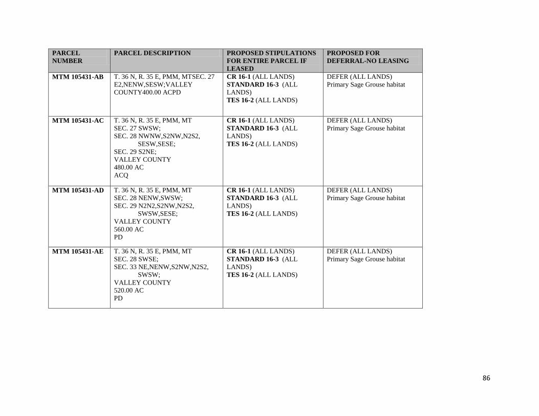
86
PARCEL
NUMBER
PARCEL DESCRIPTION PROPOSED STIPULATIONS
FOR ENTIRE PARCEL IF
LEASED
PROPOSED FOR
DEFERRAL-NO LEASING
MTM 105431-AB T. 36 N, R. 35 E, PMM, MTSEC. 27
E2,NENW,SESW;VALLEY
COUNTY400.00 ACPD
CR 16-1 (ALL LANDS)
STANDARD 16-3 (ALL
LANDS)
TES 16-2 (ALL LANDS)
DEFER (ALL LANDS)
Primary Sage Grouse habitat
MTM 105431-AC T. 36 N, R. 35 E, PMM, MT
SEC. 27 SWSW;
SEC. 28 NWNW,S2NW,N2S2,
SESW,SESE;
SEC. 29 S2NE;
VALLEY COUNTY
480.00 AC
ACQ
CR 16-1 (ALL LANDS)
STANDARD 16-3 (ALL
LANDS)
TES 16-2 (ALL LANDS)
DEFER (ALL LANDS)
Primary Sage Grouse habitat
MTM 105431-AD T. 36 N, R. 35 E, PMM, MT
SEC. 28 NENW,SWSW;
SEC. 29 N2N2,S2NW,N2S2,
SWSW,SESE;
VALLEY COUNTY
560.00 AC
PD
CR 16-1 (ALL LANDS)
STANDARD 16-3 (ALL
LANDS)
TES 16-2 (ALL LANDS)
DEFER (ALL LANDS)
Primary Sage Grouse habitat
MTM 105431-AE T. 36 N, R. 35 E, PMM, MT
SEC. 28 SWSE;
SEC. 33 NE,NENW,S2NW,N2S2,
SWSW;
VALLEY COUNTY
520.00 AC
PD
CR 16-1 (ALL LANDS)
STANDARD 16-3 (ALL
LANDS)
TES 16-2 (ALL LANDS)
DEFER (ALL LANDS)
Primary Sage Grouse habitat
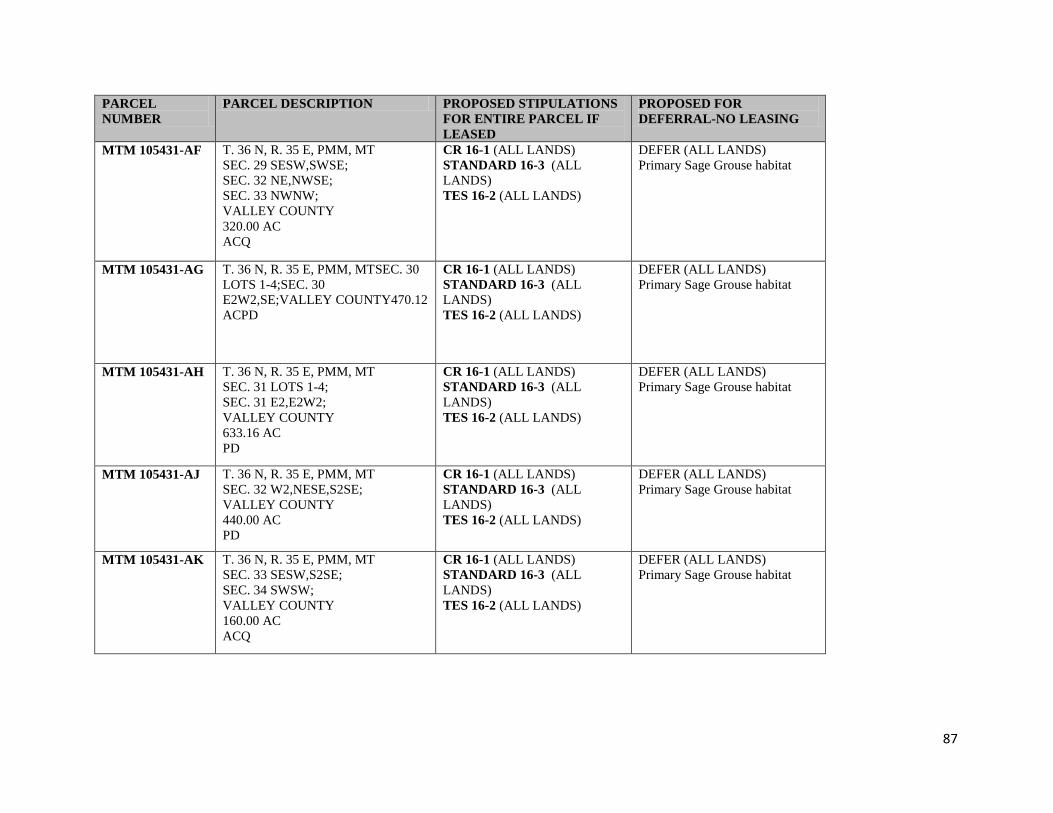
87
PARCEL
NUMBER
PARCEL DESCRIPTION PROPOSED STIPULATIONS
FOR ENTIRE PARCEL IF
LEASED
PROPOSED FOR
DEFERRAL-NO LEASING
MTM 105431-AF T. 36 N, R. 35 E, PMM, MT
SEC. 29 SESW,SWSE;
SEC. 32 NE,NWSE;
SEC. 33 NWNW;
VALLEY COUNTY
320.00 AC
ACQ
CR 16-1 (ALL LANDS)
STANDARD 16-3 (ALL
LANDS)
TES 16-2 (ALL LANDS)
DEFER (ALL LANDS)
Primary Sage Grouse habitat
MTM 105431-AG T. 36 N, R. 35 E, PMM, MTSEC. 30
LOTS 1-4;SEC. 30
E2W2,SE;VALLEY COUNTY470.12
ACPD
CR 16-1 (ALL LANDS)
STANDARD 16-3 (ALL
LANDS)
TES 16-2 (ALL LANDS)
DEFER (ALL LANDS)
Primary Sage Grouse habitat
MTM 105431-AH T. 36 N, R. 35 E, PMM, MT
SEC. 31 LOTS 1-4;
SEC. 31 E2,E2W2;
VALLEY COUNTY
633.16 AC
PD
CR 16-1 (ALL LANDS)
STANDARD 16-3 (ALL
LANDS)
TES 16-2 (ALL LANDS)
DEFER (ALL LANDS)
Primary Sage Grouse habitat
MTM 105431-AJ T. 36 N, R. 35 E, PMM, MT
SEC. 32 W2,NESE,S2SE;
VALLEY COUNTY
440.00 AC
PD
CR 16-1 (ALL LANDS)
STANDARD 16-3 (ALL
LANDS)
TES 16-2 (ALL LANDS)
DEFER (ALL LANDS)
Primary Sage Grouse habitat
MTM 105431-AK T. 36 N, R. 35 E, PMM, MT
SEC. 33 SESW,S2SE;
SEC. 34 SWSW;
VALLEY COUNTY
160.00 AC
ACQ
CR 16-1 (ALL LANDS)
STANDARD 16-3 (ALL
LANDS)
TES 16-2 (ALL LANDS)
DEFER (ALL LANDS)
Primary Sage Grouse habitat
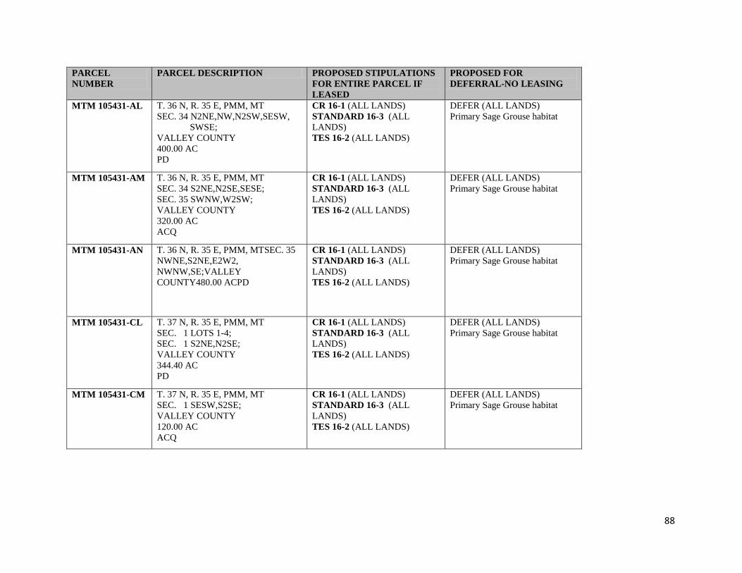
88
PARCEL
NUMBER
PARCEL DESCRIPTION PROPOSED STIPULATIONS
FOR ENTIRE PARCEL IF
LEASED
PROPOSED FOR
DEFERRAL-NO LEASING
MTM 105431-AL T. 36 N, R. 35 E, PMM, MT
SEC. 34 N2NE,NW,N2SW,SESW,
SWSE;
VALLEY COUNTY
400.00 AC
PD
CR 16-1 (ALL LANDS)
STANDARD 16-3 (ALL
LANDS)
TES 16-2 (ALL LANDS)
DEFER (ALL LANDS)
Primary Sage Grouse habitat
MTM 105431-AM T. 36 N, R. 35 E, PMM, MT
SEC. 34 S2NE,N2SE,SESE;
SEC. 35 SWNW,W2SW;
VALLEY COUNTY
320.00 AC
ACQ
CR 16-1 (ALL LANDS)
STANDARD 16-3 (ALL
LANDS)
TES 16-2 (ALL LANDS)
DEFER (ALL LANDS)
Primary Sage Grouse habitat
MTM 105431-AN T. 36 N, R. 35 E, PMM, MTSEC. 35
NWNE,S2NE,E2W2,
NWNW,SE;VALLEY
COUNTY480.00 ACPD
CR 16-1 (ALL LANDS)
STANDARD 16-3 (ALL
LANDS)
TES 16-2 (ALL LANDS)
DEFER (ALL LANDS)
Primary Sage Grouse habitat
MTM 105431-CL T. 37 N, R. 35 E, PMM, MT
SEC. 1 LOTS 1-4;
SEC. 1 S2NE,N2SE;
VALLEY COUNTY
344.40 AC
PD
CR 16-1 (ALL LANDS)
STANDARD 16-3 (ALL
LANDS)
TES 16-2 (ALL LANDS)
DEFER (ALL LANDS)
Primary Sage Grouse habitat
MTM 105431-CM T. 37 N, R. 35 E, PMM, MT
SEC. 1 SESW,S2SE;
VALLEY COUNTY
120.00 AC
ACQ
CR 16-1 (ALL LANDS)
STANDARD 16-3 (ALL
LANDS)
TES 16-2 (ALL LANDS)
DEFER (ALL LANDS)
Primary Sage Grouse habitat
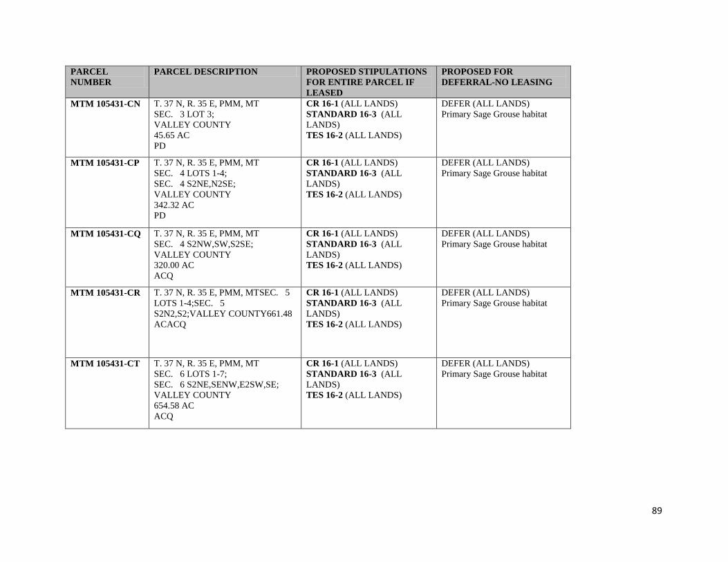
89
PARCEL
NUMBER
PARCEL DESCRIPTION PROPOSED STIPULATIONS
FOR ENTIRE PARCEL IF
LEASED
PROPOSED FOR
DEFERRAL-NO LEASING
MTM 105431-CN T. 37 N, R. 35 E, PMM, MT
SEC. 3 LOT 3;
VALLEY COUNTY
45.65 AC
PD
CR 16-1 (ALL LANDS)
STANDARD 16-3 (ALL
LANDS)
TES 16-2 (ALL LANDS)
DEFER (ALL LANDS)
Primary Sage Grouse habitat
MTM 105431-CP T. 37 N, R. 35 E, PMM, MT
SEC. 4 LOTS 1-4;
SEC. 4 S2NE,N2SE;
VALLEY COUNTY
342.32 AC
PD
CR 16-1 (ALL LANDS)
STANDARD 16-3 (ALL
LANDS)
TES 16-2 (ALL LANDS)
DEFER (ALL LANDS)
Primary Sage Grouse habitat
MTM 105431-CQ T. 37 N, R. 35 E, PMM, MT
SEC. 4 S2NW,SW,S2SE;
VALLEY COUNTY
320.00 AC
ACQ
CR 16-1 (ALL LANDS)
STANDARD 16-3 (ALL
LANDS)
TES 16-2 (ALL LANDS)
DEFER (ALL LANDS)
Primary Sage Grouse habitat
MTM 105431-CR T. 37 N, R. 35 E, PMM, MTSEC. 5
LOTS 1-4;SEC. 5
S2N2,S2;VALLEY COUNTY661.48
ACACQ
CR 16-1 (ALL LANDS)
STANDARD 16-3 (ALL
LANDS)
TES 16-2 (ALL LANDS)
DEFER (ALL LANDS)
Primary Sage Grouse habitat
MTM 105431-CT T. 37 N, R. 35 E, PMM, MT
SEC. 6 LOTS 1-7;
SEC. 6 S2NE,SENW,E2SW,SE;
VALLEY COUNTY
654.58 AC
ACQ
CR 16-1 (ALL LANDS)
STANDARD 16-3 (ALL
LANDS)
TES 16-2 (ALL LANDS)
DEFER (ALL LANDS)
Primary Sage Grouse habitat

90
PARCEL
NUMBER
PARCEL DESCRIPTION PROPOSED STIPULATIONS
FOR ENTIRE PARCEL IF
LEASED
PROPOSED FOR
DEFERRAL-NO LEASING
MTM 105431-CU T. 37 N, R. 35 E, PMM, MT
SEC. 7 LOTS 1-3;
SEC. 7 E2W2;
VALLEY COUNTY
276.60 AC
PD
CR 16-1 (ALL LANDS)
STANDARD 16-3 (ALL
LANDS)
TES 16-2 (ALL LANDS)
DEFER (ALL LANDS)
Primary Sage Grouse habitat
MTM 105431-CV T. 37 N, R. 35 E, PMM, MT
SEC. 7 LOT 4;
SEC. 7 E2;
SEC. 8 W2W2;
VALLEY COUNTY
519.04 AC
ACQ
CR 16-1 (ALL LANDS)
STANDARD 16-3 (ALL
LANDS)
TES 16-2 (ALL LANDS)
DEFER (ALL LANDS)
Primary Sage Grouse habitat
MTM 105431-CW T. 37 N, R. 35 E, PMM, MT
SEC. 8 E2E2;
SEC. 9 W2,S2SE;
VALLEY COUNTY
560.00 AC
PD
CR 16-1 (ALL LANDS)
STANDARD 16-3 (ALL
LANDS)
TES 16-2 (ALL LANDS)
DEFER (ALL LANDS)
Primary Sage Grouse habitat
MTM 105431-CX T. 37 N, R. 35 E, PMM, MT
SEC. 9 NE,N2SE;
SEC. 10 SWNW,NWSW;
VALLEY COUNTY
320.00 AC
ACQ
CR 16-1 (ALL LANDS)
STANDARD 16-3 (ALL
LANDS)
TES 16-2 (ALL LANDS)
DEFER (ALL LANDS)
Primary Sage Grouse habitat
MTM 105431-CY T. 37 N, R. 35 E, PMM, MTSEC. 10
E2,E2W2,SWSW;VALLEY
COUNTY520.00 ACPD
CR 16-1 (ALL LANDS)
STANDARD 16-3 (ALL
LANDS)
TES 16-2 (ALL LANDS)
DEFER (ALL LANDS)
Primary Sage Grouse habitat
91
PARCEL
NUMBER
PARCEL DESCRIPTION PROPOSED STIPULATIONS
FOR ENTIRE PARCEL IF
LEASED
PROPOSED FOR
DEFERRAL-NO LEASING
MTM 105431-C3 T. 37 N, R. 35 E, PMM, MT
SEC. 11 ALL;
VALLEY COUNTY
640.00 AC
ACQ
CR 16-1 (ALL LANDS)
STANDARD 16-3 (ALL
LANDS)
TES 16-2 (ALL LANDS)
DEFER (ALL LANDS)
Primary Sage Grouse habitat
MTM 105431-C4 T. 37 N, R. 35 E, PMM, MT
SEC. 13 N2NE;
VALLEY COUNTY
80.00 AC
PD
CR 16-1 (ALL LANDS)
STANDARD 16-3 (ALL
LANDS)
TES 16-2 (ALL LANDS)
DEFER (ALL LANDS)
Primary Sage Grouse habitat
MTM 105431-C6 T. 37 N, R. 35 E, PMM, MT
SEC. 13 NW,NESW;
SEC. 14 N2NE,SENE;
VALLEY COUNTY
320.00 AC
ACQ
CR 16-1 (ALL LANDS)
STANDARD 16-3 (ALL
LANDS)
TES 16-2 (ALL LANDS)
DEFER (ALL LANDS)
Primary Sage Grouse habitat
MTM 105431-C7 T. 37 N, R. 35 E, PMM, MT
SEC. 13 NWSW,SESW;
VALLEY COUNTY
80.00 AC
PD
CR 16-1 (ALL LANDS)
STANDARD 16-3 (ALL
LANDS)
TES 16-2 (ALL LANDS)
DEFER (ALL LANDS)
Primary Sage Grouse habitat
MTM 105431-C8 T. 37 N, R. 35 E, PMM, MT
SEC. 14 SWNE,NW,N2SW,
SESW,SE;
SEC. 15 NENE;
SEC. 23 N2NE;
VALLEY COUNTY
600.00 AC
PD
CR 16-1 (ALL LANDS)
STANDARD 16-3 (ALL
LANDS)
TES 16-2 (ALL LANDS)
DEFER (ALL LANDS)
Primary Sage Grouse habitat

92
PARCEL
NUMBER
PARCEL DESCRIPTION PROPOSED STIPULATIONS
FOR ENTIRE PARCEL IF
LEASED
PROPOSED FOR
DEFERRAL-NO LEASING
MTM 105431-C9 T. 37 N, R. 35 E, PMM, MTSEC. 15
W2;VALLEY COUNTY320.00
ACPD
CR 16-1 (ALL LANDS)
STANDARD 16-3 (ALL
LANDS)
TES 16-2 (ALL LANDS)
DEFER (ALL LANDS)
Primary Sage Grouse habitat
MTM 105431-DA T. 37 N, R. 35 E, PMM, MT
SEC. 17 E2,E2W2,W2SW;
VALLEY COUNTY
560.00 AC
PD
CR 16-1 (ALL LANDS)
STANDARD 16-3 (ALL
LANDS)
TES 16-2 (ALL LANDS)
DEFER (ALL LANDS)
Primary Sage Grouse habitat
MTM 105431-DB T. 37 N, R. 35 E, PMM, MT
SEC. 17 W2NW;
SEC. 18 LOTS 1-4;
SEC. 18 NE,E2W2;
VALLEY COUNTY
557.00 AC
ACQ
CR 16-1 (ALL LANDS)
STANDARD 16-3 (ALL
LANDS)
TES 16-2 (ALL LANDS)
DEFER (ALL LANDS)
Primary Sage Grouse habitat
MTM 105431-DC T. 37 N, R. 35 E, PMM, MT
SEC. 18 SE;
VALLEY COUNTY
160.00 AC
PD
CR 16-1 (ALL LANDS)
STANDARD 16-3 (ALL
LANDS)
TES 16-2 (ALL LANDS)
DEFER (ALL LANDS)
Primary Sage Grouse habitat
MTM 105431-DD T. 37 N, R. 35 E, PMM, MT
SEC. 19 LOTS 1-3;
SEC. 19 NE,E2NW,NESW,N2SE,
SESE;
VALLEY COUNTY
518.69 AC
PD
CR 16-1 (ALL LANDS)
STANDARD 16-3 (ALL
LANDS)
TES 16-2 (ALL LANDS)
DEFER (ALL LANDS)
Primary Sage Grouse habitat

93
PARCEL
NUMBER
PARCEL DESCRIPTION PROPOSED STIPULATIONS
FOR ENTIRE PARCEL IF
LEASED
PROPOSED FOR
DEFERRAL-NO LEASING
MTM 105431-DE T. 37 N, R. 35 E, PMM, MT
SEC. 19 LOT 4;
SEC. 19 SESW,SWSE;
SEC. 30 LOT 1;
SEC. 30 NWNE,NENW;
VALLEY COUNTY
239.59 AC
ACQ
CR 16-1 (ALL LANDS)
STANDARD 16-3 (ALL
LANDS)
TES 16-2 (ALL LANDS)
DEFER (ALL LANDS)
Primary Sage Grouse habitat
MTM 105431-DG T. 37 N, R. 35 E, PMM, MTSEC. 20
E2;VALLEY COUNTY320.00 ACPD
CR 16-1 (ALL LANDS)
STANDARD 16-3 (ALL
LANDS)
TES 16-2 (ALL LANDS)
DEFER (ALL LANDS)
Primary Sage Grouse habitat
MTM 105431-DF T. 37 N, R. 35 E, PMM, MT
SEC. 20 W2;
VALLEY COUNTY
320.00 AC
ACQ
CR 16-1 (ALL LANDS)
STANDARD 16-3 (ALL
LANDS)
TES 16-2 (ALL LANDS)
DEFER (ALL LANDS)
Primary Sage Grouse habitat
MTM 105431-DH T. 37 N, R. 35 E, PMM, MT
SEC. 21 N2,E2SW,NESE,S2SE;
SEC. 28 NENW;
VALLEY COUNTY
560.00 AC
ACQ
CR 16-1 (ALL LANDS)
STANDARD 16-3 (ALL
LANDS)
TES 16-2 (ALL LANDS)
DEFER (ALL LANDS)
Primary Sage Grouse habitat
MTM 105431-DJ T. 37 N, R. 35 E, PMM, MT
SEC. 21 W2SW,NWSE;
SEC. 28 W2NE,NWNW,S2NW;
VALLEY COUNTY
320.00 AC
PD
CR 16-1 (ALL LANDS)
STANDARD 16-3 (ALL
LANDS)
TES 16-2 (ALL LANDS)
DEFER (ALL LANDS)
Primary Sage Grouse habitat

94
PARCEL
NUMBER
PARCEL DESCRIPTION PROPOSED STIPULATIONS
FOR ENTIRE PARCEL IF
LEASED
PROPOSED FOR
DEFERRAL-NO LEASING
MTM 105431-DK T. 37 N, R. 35 E, PMM, MT
SEC. 22 N2,W2SW,SE;
VALLEY COUNTY
560.00 AC
ACQ
CR 16-1 (ALL LANDS)
STANDARD 16-3 (ALL
LANDS)
TES 16-2 (ALL LANDS)
DEFER (ALL LANDS)
Primary Sage Grouse habitat
MTM 105431-DL T. 37 N, R. 35 E, PMM, MT
SEC. 22 E2SW;
VALLEY COUNTY
80.00 AC
PD
CR 16-1 (ALL LANDS)
STANDARD 16-3 (ALL
LANDS)
TES 16-2 (ALL LANDS)
DEFER (ALL LANDS)
Primary Sage Grouse habitat
MTM 105431-DM T. 37 N, R. 35 E, PMM, MT
SEC. 23 SWNE,NW,E2SW,W2SE;
VALLEY COUNTY
360.00 AC
ACQ
CR 16-1 (ALL LANDS)
STANDARD 16-3 (ALL
LANDS)
TES 16-2 (ALL LANDS)
DEFER (ALL LANDS)
Primary Sage Grouse habitat
MTM 105431-DN T. 37 N, R. 35 E, PMM, MTSEC. 23
W2SW,E2SE;VALLEY
COUNTY160.00 ACPD
CR 16-1 (ALL LANDS)
STANDARD 16-3 (ALL
LANDS)
TES 16-2 (ALL LANDS)
DEFER (ALL LANDS)
Primary Sage Grouse habitat
MTM 105431-DP T. 37 N, R. 35 E, PMM, MT
SEC. 24 W2SW,NWSE,S2SE;
VALLEY COUNTY
200.00 AC
PD
CR 16-1 (ALL LANDS)
STANDARD 16-3 (ALL
LANDS)
TES 16-2 (ALL LANDS)
DEFER (ALL LANDS)
Primary Sage Grouse habitat
MTM 105431-DQ T. 37 N, R. 35 E, PMM, MT
SEC. 25 E2,N2NW,SENW;
VALLEY COUNTY
440.00 AC
PD
CR 16-1 (ALL LANDS)
STANDARD 16-3 (ALL
LANDS)
TES 16-2 (ALL LANDS)
DEFER (ALL LANDS)
Primary Sage Grouse habitat

95
PARCEL
NUMBER
PARCEL DESCRIPTION PROPOSED STIPULATIONS
FOR ENTIRE PARCEL IF
LEASED
PROPOSED FOR
DEFERRAL-NO LEASING
MTM 105431-DR T. 37 N, R. 35 E, PMM, MT
SEC. 25 SWNW,SW;
VALLEY COUNTY
200.00 AC
ACQ
CR 16-1 (ALL LANDS)
STANDARD 16-3 (ALL
LANDS)
TES 16-2 (ALL LANDS)
DEFER (ALL LANDS)
Primary Sage Grouse habitat
MTM 105431-DT T. 37 N, R. 35 E, PMM, MT
SEC. 26 E2,E2NW;
VALLEY COUNTY
400.00 AC
ACQ
CR 16-1 (ALL LANDS)
STANDARD 16-3 (ALL
LANDS)
TES 16-2 (ALL LANDS)
DEFER (ALL LANDS)
Primary Sage Grouse habitat
MTM 105431-DU T. 37 N, R. 35 E, PMM, MT
SEC. 26 W2NW;
SEC. 27 NE,E2NW,SW,W2SE;
VALLEY COUNTY
560.00 AC
PD
CR 16-1 (ALL LANDS)
STANDARD 16-3 (ALL
LANDS)
TES 16-2 (ALL LANDS)
DEFER (ALL LANDS)
Primary Sage Grouse habitat
MTM 105431-DV T. 37 N, R. 35 E, PMM, MT
SEC. 27 W2NW;
SEC. 28 E2NE;
VALLEY COUNTY
160.00 AC
ACQ
CR 16-1 (ALL LANDS)
STANDARD 16-3 (ALL
LANDS)
TES 16-2 (ALL LANDS)
DEFER (ALL LANDS)
Primary Sage Grouse habitat
MTM 105431-DW T. 37 N, R. 35 E, PMM, MTSEC. 28
S2;VALLEY COUNTY320.00 ACPD
CR 16-1 (ALL LANDS)
STANDARD 16-3 (ALL
LANDS)
TES 16-2 (ALL LANDS)
DEFER (ALL LANDS)
Primary Sage Grouse habitat
MTM 105431-DX T. 37 N, R. 35 E, PMM, MT
SEC. 29 ALL;
VALLEY COUNTY
640.00 AC
PD
CR 16-1 (ALL LANDS)
STANDARD 16-3 (ALL
LANDS)
TES 16-2 (ALL LANDS)
DEFER (ALL LANDS)
Primary Sage Grouse habitat

96
PARCEL
NUMBER
PARCEL DESCRIPTION PROPOSED STIPULATIONS
FOR ENTIRE PARCEL IF
LEASED
PROPOSED FOR
DEFERRAL-NO LEASING
MTM 105431-DY T. 37 N, R. 35 E, PMM, MT
SEC. 30 E2E2,SWSE;
VALLEY COUNTY
200.00 AC
PD
CR 16-1 (ALL LANDS)
STANDARD 16-3 (ALL
LANDS)
TES 16-2 (ALL LANDS)
DEFER (ALL LANDS)
Primary Sage Grouse habitat
MTM 105431-D3 T. 37 N, R. 35 E, PMM, MT
SEC. 31 LOTS 1-4;
SEC. 31 E2,E2W2;
VALLEY COUNTY
640.16 AC
PD
CR 16-1 (ALL LANDS)
STANDARD 16-3 (ALL
LANDS)
TES 16-2 (ALL LANDS)
DEFER (ALL LANDS)
Primary Sage Grouse habitat
MTM 105431-D4 T. 37 N, R. 35 E, PMM, MT
SEC. 32 E2,NENW,NWSW,S2SW;
VALLEY COUNTY
480.00 AC
PD
CR 16-1 (ALL LANDS)
STANDARD 16-3 (ALL
LANDS)
TES 16-2 (ALL LANDS)
DEFER (ALL LANDS)
Primary Sage Grouse habitat
MTM 105431-D6 T. 37 N, R. 35 E, PMM, MT
SEC. 32 NWNW,S2NW,NESW;
VALLEY COUNTY
160.00 AC
ACQ
CR 16-1 (ALL LANDS)
STANDARD 16-3 (ALL
LANDS)
TES 16-2 (ALL LANDS)
DEFER (ALL LANDS)
Primary Sage Grouse habitat
MTM 105431-D7 T. 37 N, R. 35 E, PMM, MT
SEC. 33 ALL;
VALLEY COUNTY
640.00 AC
PD
CR 16-1 (ALL LANDS)
STANDARD 16-3 (ALL
LANDS)
TES 16-2 (ALL LANDS)
DEFER (ALL LANDS)
Primary Sage Grouse habitat
MTM 105431-D8 T. 37 N, R. 35 E, PMM, MTSEC. 34
W2NE,NW,S2;VALLEY
COUNTY560.00 ACPD
CR 16-1 (ALL LANDS)
STANDARD 16-3 (ALL
LANDS)
TES 16-2 (ALL LANDS)
DEFER (ALL LANDS)
Primary Sage Grouse habitat
97
PARCEL
NUMBER
PARCEL DESCRIPTION PROPOSED STIPULATIONS
FOR ENTIRE PARCEL IF
LEASED
PROPOSED FOR
DEFERRAL-NO LEASING
MTM 105431-D9 T. 37 N, R. 35 E, PMM, MT
SEC. 35 ALL;
VALLEY COUNTY
640.00 AC
PD
CR 16-1 (ALL LANDS)
STANDARD 16-3 (ALL
LANDS)
TES 16-2 (ALL LANDS)
DEFER (ALL LANDS)
Primary Sage Grouse habitat
MTM 102757-7M T. 35 N, R. 36 E, PMM, MT
SEC. 1 LOTS 1,2;
SEC. 1 S2NE,SE;
VALLEY COUNTY
320.22 AC
ACQ
CR 16-1 (ALL LANDS)
STANDARD 16-3 (ALL
LANDS)
TES 16-2 (ALL LANDS)
DEFER (ALL LANDS)
Primary Sage Grouse habitat
MTM 102757-7N T. 35 N, R. 36 E, PMM, MT
SEC. 1 LOTS 3,4;
SEC. 1 S2NW,E2SW;
VALLEY COUNTY
240.66 AC
ACQ
CR 16-1 (ALL LANDS)
STANDARD 16-3 (ALL
LANDS)
TES 16-2 (ALL LANDS)
DEFER (ALL LANDS)
Primary Sage Grouse habitat
MTM 102757-7P T. 35 N, R. 36 E, PMM, MT
SEC. 2 LOTS 1,2;
SEC. 2 S2NE,SE;
VALLEY COUNTY
320.76 AC
ACQ
CR 16-1 (ALL LANDS)
STANDARD 16-3 (ALL
LANDS)
TES 16-2 (ALL LANDS)
DEFER (ALL LANDS)
Primary Sage Grouse habitat
MTM 102757-7Q T. 35 N, R. 36 E, PMM, MT
SEC. 3 LOT 1;
SEC. 3 SENE,SE;
VALLEY COUNTY
240.09 AC
ACQ
CR 16-1 (ALL LANDS)
STANDARD 16-3 (ALL
LANDS)
TES 16-2 (ALL LANDS)
DEFER (ALL LANDS)
Primary Sage Grouse habitat

98
PARCEL
NUMBER
PARCEL DESCRIPTION PROPOSED STIPULATIONS
FOR ENTIRE PARCEL IF
LEASED
PROPOSED FOR
DEFERRAL-NO LEASING
MTM 102757-7R T. 35 N, R. 36 E, PMM, MTSEC. 3
W2SW;SEC. 4 E2SE;VALLEY
COUNTY160.00 ACACQ
CR 16-1 (ALL LANDS)
STANDARD 16-3 (ALL
LANDS)
TES 16-2 (ALL LANDS)
DEFER (ALL LANDS)
Primary Sage Grouse habitat
MTM 102757-7T T. 35 N, R. 36 E, PMM, MT
SEC. 4 LOTS 1-4;
SEC. 4 S2N2;
VALLEY COUNTY
319.04 AC
ACQ
CR 16-1 (ALL LANDS)
STANDARD 16-3 (ALL
LANDS)
TES 16-2 (ALL LANDS)
DEFER (ALL LANDS)
Primary Sage Grouse habitat
MTM 102757-7U T. 35 N, R. 36 E, PMM, MT
SEC. 5 SW,W2SE;
VALLEY COUNTY
240.00 AC
ACQ
CR 16-1 (ALL LANDS)
STANDARD 16-3 (ALL
LANDS)
TES 16-2 (ALL LANDS)
DEFER (ALL LANDS)
Primary Sage Grouse habitat
MTM 102757-7V T. 35 N, R. 36 E, PMM, MT
SEC. 6 E2SW,SE;
VALLEY COUNTY
240.00 AC
ACQ
CR 16-1 (ALL LANDS)
STANDARD 16-3 (ALL
LANDS)
TES 16-2 (ALL LANDS)
DEFER (ALL LANDS)
Primary Sage Grouse habitat
MTM 102757-7W T. 35 N, R. 36 E, PMM, MT
SEC. 7 LOTS 1-4;
SEC. 7 E2,E2W2;
VALLEY COUNTY
630.04 AC
ACQ
CR 16-1 (ALL LANDS)
STANDARD 16-3 (ALL
LANDS)
TES 16-2 (ALL LANDS)
DEFER (ALL LANDS)
Primary Sage Grouse habitat
MTM 102757-7X T. 35 N, R. 36 E, PMM, MT
SEC. 8 NE,E2NW,S2;
VALLEY COUNTY
560.00 AC
ACQ
CR 16-1 (ALL LANDS)
STANDARD 16-3 (ALL
LANDS)
TES 16-2 (ALL LANDS)
DEFER (ALL LANDS)
Primary Sage Grouse habitat

99
PARCEL
NUMBER
PARCEL DESCRIPTION PROPOSED STIPULATIONS
FOR ENTIRE PARCEL IF
LEASED
PROPOSED FOR
DEFERRAL-NO LEASING
MTM 102757-7Y T. 35 N, R. 36 E, PMM, MT
SEC. 9 ALL;
VALLEY COUNTY
640.00 AC
ACQ
CR 16-1 (ALL LANDS)
STANDARD 16-3 (ALL
LANDS)
TES 16-2 (ALL LANDS)
DEFER (ALL LANDS)
Primary Sage Grouse habitat
MTM 102757-73 T. 35 N, R. 36 E, PMM, MTSEC. 10
ALL;VALLEY COUNTY640.00
ACACQ
CR 16-1 (ALL LANDS)
STANDARD 16-3 (ALL
LANDS)
TES 16-2 (ALL LANDS)
DEFER (ALL LANDS)
Primary Sage Grouse habitat
MTM 102757-74 T. 35 N, R. 36 E, PMM, MT
SEC. 11 ALL;
VALLEY COUNTY
640.00 AC
ACQ
CR 16-1 (ALL LANDS)
STANDARD 16-3 (ALL
LANDS)
TES 16-2 (ALL LANDS)
DEFER (ALL LANDS)
Primary Sage Grouse habitat
MTM 102757-76 T. 35 N, R. 36 E, PMM, MT
SEC. 12 N2,SW,S2SE;
VALLEY COUNTY
560.00 AC
ACQ
CR 16-1 (ALL LANDS)
STANDARD 16-3 (ALL
LANDS)
TES 16-2 (ALL LANDS)
DEFER (ALL LANDS)
Primary Sage Grouse habitat
MTM 102757-77 T. 35 N, R. 36 E, PMM, MT
SEC. 13 E2,E2NW,W2SW;
VALLEY COUNTY
480.00 AC
ACQ
CR 16-1 (ALL LANDS)
STANDARD 16-3 (ALL
LANDS)
TES 16-2 (ALL LANDS)
DEFER (ALL LANDS)
Primary Sage Grouse habitat
MTM 102757-78 T. 35 N, R. 36 E, PMM, MT
SEC. 14 W2NE,NW,S2;
VALLEY COUNTY
560.00 AC
ACQ
CR 16-1 (ALL LANDS)
STANDARD 16-3 (ALL
LANDS)
TES 16-2 (ALL LANDS)
DEFER (ALL LANDS)
Primary Sage Grouse habitat
100
PARCEL
NUMBER
PARCEL DESCRIPTION PROPOSED STIPULATIONS
FOR ENTIRE PARCEL IF
LEASED
PROPOSED FOR
DEFERRAL-NO LEASING
MTM 102757-79 T. 35 N, R. 36 E, PMM, MT
SEC. 15 ALL;
VALLEY COUNTY
640.00 AC
ACQ
CR 16-1 (ALL LANDS)
STANDARD 16-3 (ALL
LANDS)
TES 16-2 (ALL LANDS)
DEFER (ALL LANDS)
Primary Sage Grouse habitat
MTM 102757-8A T. 35 N, R. 36 E, PMM, MT
SEC. 17 N2,E2SW,SE;
VALLEY COUNTY
560.00 AC
ACQ
CR 16-1 (ALL LANDS)
STANDARD 16-3 (ALL
LANDS)
TES 16-2 (ALL LANDS)
DEFER (ALL LANDS)
Primary Sage Grouse habitat
MTM 102757-8B T. 35 N, R. 36 E, PMM, MTSEC. 18
LOTS 1-4;SEC. 18
E2,E2SW;VALLEY COUNTY548.20
ACACQ
CR 16-1 (ALL LANDS)
STANDARD 16-3 (ALL
LANDS)
TES 16-2 (ALL LANDS)
DEFER (ALL LANDS)
Primary Sage Grouse habitat
MTM 102757-8C T. 35 N, R. 36 E, PMM, MT
SEC. 19 E2;
VALLEY COUNTY
320.00 AC
ACQ
CR 16-1 (ALL LANDS)
STANDARD 16-3 (ALL
LANDS)
TES 16-2 (ALL LANDS)
DEFER (ALL LANDS)
Primary Sage Grouse habitat
MTM 102757-8D T. 35 N, R. 36 E, PMM, MT
SEC. 20 ALL;
VALLEY COUNTY
640.00 AC
ACQ
CR 16-1 (ALL LANDS)
STANDARD 16-3 (ALL
LANDS)
TES 16-2 (ALL LANDS)
DEFER (ALL LANDS)
Primary Sage Grouse habitat
MTM 102757-8E T. 35 N, R. 36 E, PMM, MT
SEC. 21 ALL;
VALLEY COUNTY
640.00 AC
ACQ
CR 16-1 (ALL LANDS)
STANDARD 16-3 (ALL
LANDS)
TES 16-2 (ALL LANDS)
DEFER (ALL LANDS)
Primary Sage Grouse habitat
101
PARCEL
NUMBER
PARCEL DESCRIPTION PROPOSED STIPULATIONS
FOR ENTIRE PARCEL IF
LEASED
PROPOSED FOR
DEFERRAL-NO LEASING
MTM 102757-8F T. 35 N, R. 36 E, PMM, MT
SEC. 22 NE,W2NENW,NWNW,
S2NW,S2;
VALLEY COUNTY
620.00 AC
ACQ
CR 16-1 (ALL LANDS)
STANDARD 16-3 (ALL
LANDS)
TES 16-2 (ALL LANDS)
DEFER (ALL LANDS)
Primary Sage Grouse habitat
MTM 102757-8G T. 35 N, R. 36 E, PMM, MT
SEC. 23 NE,E2NW,N2SW,SWSW,
NWSE;
VALLEY COUNTY
400.00 AC
ACQ
CR 16-1 (ALL LANDS)
STANDARD 16-3 (ALL
LANDS)
TES 16-2 (ALL LANDS)
DEFER (ALL LANDS)
Primary Sage Grouse habitat
MTM 102757-8H T. 35 N, R. 36 E, PMM, MT
SEC. 23 NESE;
VALLEY COUNTY
40.00 AC
PD
CR 16-1 (ALL LANDS)
STANDARD 16-3 (ALL
LANDS)
TES 16-2 (ALL LANDS)
DEFER (ALL LANDS)
Primary Sage Grouse habitat
MTM 102757-8J T. 35 N, R. 36 E, PMM, MTSEC. 24
E2,E2SW;VALLEY COUNTY400.00
ACACQ
CR 16-1 (ALL LANDS)
STANDARD 16-3 (ALL
LANDS)
TES 16-2 (ALL LANDS)
DEFER (ALL LANDS)
Primary Sage Grouse habitat
MTM 102757-8K T. 35 N, R. 36 E, PMM, MT
SEC. 25 ALL;
VALLEY COUNTY
640.00 AC
PD
CR 16-1 (ALL LANDS)
STANDARD 16-3 (ALL
LANDS)
TES 16-2 (ALL LANDS)
DEFER (ALL LANDS)
Primary Sage Grouse habitat
MTM 102757-8L T. 35 N, R. 36 E, PMM, MT
SEC. 26 N2NE;
VALLEY COUNTY
80.00 AC
PD
CR 16-1 (ALL LANDS)
STANDARD 16-3 (ALL
LANDS)
TES 16-2 (ALL LANDS)
DEFER (ALL LANDS)
Primary Sage Grouse habitat

102
PARCEL
NUMBER
PARCEL DESCRIPTION PROPOSED STIPULATIONS
FOR ENTIRE PARCEL IF
LEASED
PROPOSED FOR
DEFERRAL-NO LEASING
MTM 102757-8M T. 35 N, R. 36 E, PMM, MT
SEC. 26 W2NW,NWSW;
VALLEY COUNTY
120.00 AC
ACQ
CR 16-1 (ALL LANDS)
STANDARD 16-3 (ALL
LANDS)
TES 16-2 (ALL LANDS)
DEFER (ALL LANDS)
Primary Sage Grouse habitat
MTM 102757-8N T. 35 N, R. 36 E, PMM, MT
SEC. 27 ALL;
VALLEY COUNTY
640.00 AC
ACQ
CR 16-1 (ALL LANDS)
STANDARD 16-3 (ALL
LANDS)
TES 16-2 (ALL LANDS)
DEFER (ALL LANDS)
Primary Sage Grouse habitat
MTM 102757-8P T. 35 N, R. 36 E, PMM, MT
SEC. 28 N2NE,SENE,NWNW,
NESE,S2SE;
VALLEY COUNTY
280.00 AC
ACQ
CR 16-1 (ALL LANDS)
STANDARD 16-3 (ALL
LANDS)
TES 16-2 (ALL LANDS)
DEFER (ALL LANDS)
Primary Sage Grouse habitat
MTM 102757-8Q T. 35 N, R. 36 E, PMM, MT
SEC. 29 E2;
VALLEY COUNTY
320.00 AC
ACQ
CR 16-1 (ALL LANDS)
STANDARD 16-3 (ALL
LANDS)
TES 16-2 (ALL LANDS)
DEFER (ALL LANDS)
Primary Sage Grouse habitat
MTM 102757-8R T. 35 N, R. 36 E, PMM, MTSEC. 30
LOTS 1,2;SEC. 30 E2NW;VALLEY
COUNTY152.01 ACACQ
CR 16-1 (ALL LANDS)
STANDARD 16-3 (ALL
LANDS)
TES 16-2 (ALL LANDS)
DEFER (ALL LANDS)
Primary Sage Grouse habitat
MTM 102757-8T T. 35 N, R. 36 E, PMM, MT
SEC. 31 LOTS 3,4;
SEC. 31 N2NE,E2SW;
VALLEY COUNTY
231.08 AC
ACQ
CR 16-1 (ALL LANDS)
STANDARD 16-3 (ALL
LANDS)
TES 16-2 (ALL LANDS)
DEFER (ALL LANDS)
Primary Sage Grouse habitat

103
PARCEL
NUMBER
PARCEL DESCRIPTION PROPOSED STIPULATIONS
FOR ENTIRE PARCEL IF
LEASED
PROPOSED FOR
DEFERRAL-NO LEASING
MTM 102757-8U T. 35 N, R. 36 E, PMM, MT
SEC. 32 N2,E2SW;
VALLEY COUNTY
400.00 AC
ACQ
CR 16-1 (ALL LANDS)
STANDARD 16-3 (ALL
LANDS)
TES 16-2 (ALL LANDS)
DEFER (ALL LANDS)
Primary Sage Grouse habitat
MTM 102757-8V T. 35 N, R. 36 E, PMM, MT
SEC. 34 N2NE;
SEC. 35 W2;
VALLEY COUNTY
400.00 AC
ACQ
CR 16-1 (ALL LANDS)
STANDARD 16-3 (ALL
LANDS)
TES 16-2 (ALL LANDS)
DEFER (ALL LANDS)
Primary Sage Grouse habitat
MTM 102757-8W T. 35 N, R. 36 E, PMM, MT
SEC. 35 S2NE,SE;
VALLEY COUNTY
240.00 AC
PD
CR 16-1 (ALL LANDS)
STANDARD 16-3 (ALL
LANDS)
TES 16-2 (ALL LANDS)
DEFER (ALL LANDS)
Primary Sage Grouse habitat
MTM 105431-AP T. 36 N, R. 36 E, PMM, MT
SEC. 1 LOTS 1-4;
SEC. 1 S2;
SEC. 2 LOT 1;
SEC. 2 NESE;
VALLEY COUNTY
555.45 AC
ACQ
CR 16-1 (ALL LANDS)
STANDARD 16-3 (ALL
LANDS)
TES 16-2 (ALL LANDS)
DEFER (ALL LANDS)
Primary Sage Grouse habitat
MTM 105431-AQ T. 36 N, R. 36 E, PMM, MTSEC. 2
LOTS 2-4;SEC. 2
SW,NWSE,S2SE;SEC. 3
S2SE;VALLEY COUNTY477.23
ACPD
CR 16-1 (ALL LANDS)
STANDARD 16-3 (ALL
LANDS)
TES 16-2 (ALL LANDS)
DEFER (ALL LANDS)
Primary Sage Grouse habitat

104
PARCEL
NUMBER
PARCEL DESCRIPTION PROPOSED STIPULATIONS
FOR ENTIRE PARCEL IF
LEASED
PROPOSED FOR
DEFERRAL-NO LEASING
MTM 105431-AR T. 36 N, R. 36 E, PMM, MT
SEC. 5 SW;
SEC. 6 LOT 6;
SEC. 6 SESW,SE;
VALLEY COUNTY
394.69 AC
PD
CR 16-1 (ALL LANDS)
STANDARD 16-3 (ALL
LANDS)
TES 16-2 (ALL LANDS)
DEFER (ALL LANDS)
Primary Sage Grouse habitat
MTM 105431-E6 T. 36 N, R. 36 E, PMM, MT
SEC. 6 LOTS 3-5;
SEC. 6 NESW;
VALLEY COUNTY
149.70 AC
PD
CR 16-1 (ALL LANDS)
STANDARD 16-3 (ALL
LANDS)
TES 16-2 (ALL LANDS)
DEFER (ALL LANDS)
Primary Sage Grouse habitat
MTM 105431-AT T. 36 N, R. 36 E, PMM, MT
SEC. 7 LOTS 1-4;
SEC. 7 E2W2,SE;
VALLEY COUNTY
459.52 AC
PD
CR 16-1 (ALL LANDS)
STANDARD 16-3 (ALL
LANDS)
TES 16-2 (ALL LANDS)
DEFER (ALL LANDS)
Primary Sage Grouse habitat
MTM 105431-AU T. 36 N, R. 36 E, PMM, MT
SEC. 7 NE;
VALLEY COUNTY
160.00 AC
ACQ
CR 16-1 (ALL LANDS)
STANDARD 16-3 (ALL
LANDS)
TES 16-2 (ALL LANDS)
DEFER (ALL LANDS)
Primary Sage Grouse habitat
MTM 105431-AV T. 36 N, R. 36 E, PMM, MT
SEC. 8 ALL;
VALLEY COUNTY
640.00 AC
ACQ
CR 16-1 (ALL LANDS)
STANDARD 16-3 (ALL
LANDS)
TES 16-2 (ALL LANDS)
DEFER (ALL LANDS)
Primary Sage Grouse habitat

105
PARCEL
NUMBER
PARCEL DESCRIPTION PROPOSED STIPULATIONS
FOR ENTIRE PARCEL IF
LEASED
PROPOSED FOR
DEFERRAL-NO LEASING
MTM 105431-AW T. 36 N, R. 36 E, PMM, MTSEC. 9
E2NE,NW,S2SE;VALLEY
COUNTY320.00 ACPD
CR 16-1 (ALL LANDS)
STANDARD 16-3 (ALL
LANDS)
TES 16-2 (ALL LANDS)
DEFER (ALL LANDS)
Primary Sage Grouse habitat
MTM 105431-AX T. 36 N, R. 36 E, PMM, MT
SEC. 9 W2NE,SW,N2SE;
VALLEY COUNTY
320.00 AC
ACQ
CR 16-1 (ALL LANDS)
STANDARD 16-3 (ALL
LANDS)
TES 16-2 (ALL LANDS)
DEFER (ALL LANDS)
Primary Sage Grouse habitat
MTM 105431-AY T. 36 N, R. 36 E, PMM, MT
SEC. 10 ALL;
VALLEY COUNTY
640.00 AC
PD
CR 16-1 (ALL LANDS)
STANDARD 16-3 (ALL
LANDS)
TES 16-2 (ALL LANDS)
DEFER (ALL LANDS)
Primary Sage Grouse habitat
MTM 105431-A3 T. 36 N, R. 36 E, PMM, MT
SEC. 11 N2,SW,N2SE,SESE;
VALLEY COUNTY
600.00 AC
PD
CR 16-1 (ALL LANDS)
STANDARD 16-3 (ALL
LANDS)
TES 16-2 (ALL LANDS)
DEFER (ALL LANDS)
Primary Sage Grouse habitat
MTM 105431-A4 T. 36 N, R. 36 E, PMM, MT
SEC. 11 SWSE;
SEC. 14 NE,E2NW,SESW;
VALLEY COUNTY
320.00 AC
ACQ
CR 16-1 (ALL LANDS)
STANDARD 16-3 (ALL
LANDS)
TES 16-2 (ALL LANDS)
DEFER (ALL LANDS)
Primary Sage Grouse habitat
MTM 105431-A6 T. 36 N, R. 36 E, PMM, MT
SEC. 12 ALL;
VALLEY COUNTY
640.00 AC
ACQ
CR 16-1 (ALL LANDS)
STANDARD 16-3 (ALL
LANDS)
TES 16-2 (ALL LANDS)
DEFER (ALL LANDS)
Primary Sage Grouse habitat
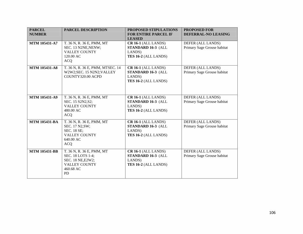
106
PARCEL
NUMBER
PARCEL DESCRIPTION PROPOSED STIPULATIONS
FOR ENTIRE PARCEL IF
LEASED
PROPOSED FOR
DEFERRAL-NO LEASING
MTM 105431-A7 T. 36 N, R. 36 E, PMM, MT
SEC. 13 N2NE,NENW;
VALLEY COUNTY
120.00 AC
ACQ
CR 16-1 (ALL LANDS)
STANDARD 16-3 (ALL
LANDS)
TES 16-2 (ALL LANDS)
DEFER (ALL LANDS)
Primary Sage Grouse habitat
MTM 105431-A8 T. 36 N, R. 36 E, PMM, MTSEC. 14
W2W2;SEC. 15 N2N2;VALLEY
COUNTY320.00 ACPD
CR 16-1 (ALL LANDS)
STANDARD 16-3 (ALL
LANDS)
TES 16-2 (ALL LANDS)
DEFER (ALL LANDS)
Primary Sage Grouse habitat
MTM 105431-A9 T. 36 N, R. 36 E, PMM, MT
SEC. 15 S2N2,S2;
VALLEY COUNTY
480.00 AC
ACQ
CR 16-1 (ALL LANDS)
STANDARD 16-3 (ALL
LANDS)
TES 16-2 (ALL LANDS)
DEFER (ALL LANDS)
Primary Sage Grouse habitat
MTM 105431-BA T. 36 N, R. 36 E, PMM, MT
SEC. 17 N2,SW;
SEC. 18 SE;
VALLEY COUNTY
640.00 AC
ACQ
CR 16-1 (ALL LANDS)
STANDARD 16-3 (ALL
LANDS)
TES 16-2 (ALL LANDS)
DEFER (ALL LANDS)
Primary Sage Grouse habitat
MTM 105431-BB T. 36 N, R. 36 E, PMM, MT
SEC. 18 LOTS 1-4;
SEC. 18 NE,E2W2;
VALLEY COUNTY
460.68 AC
PD
CR 16-1 (ALL LANDS)
STANDARD 16-3 (ALL
LANDS)
TES 16-2 (ALL LANDS)
DEFER (ALL LANDS)
Primary Sage Grouse habitat
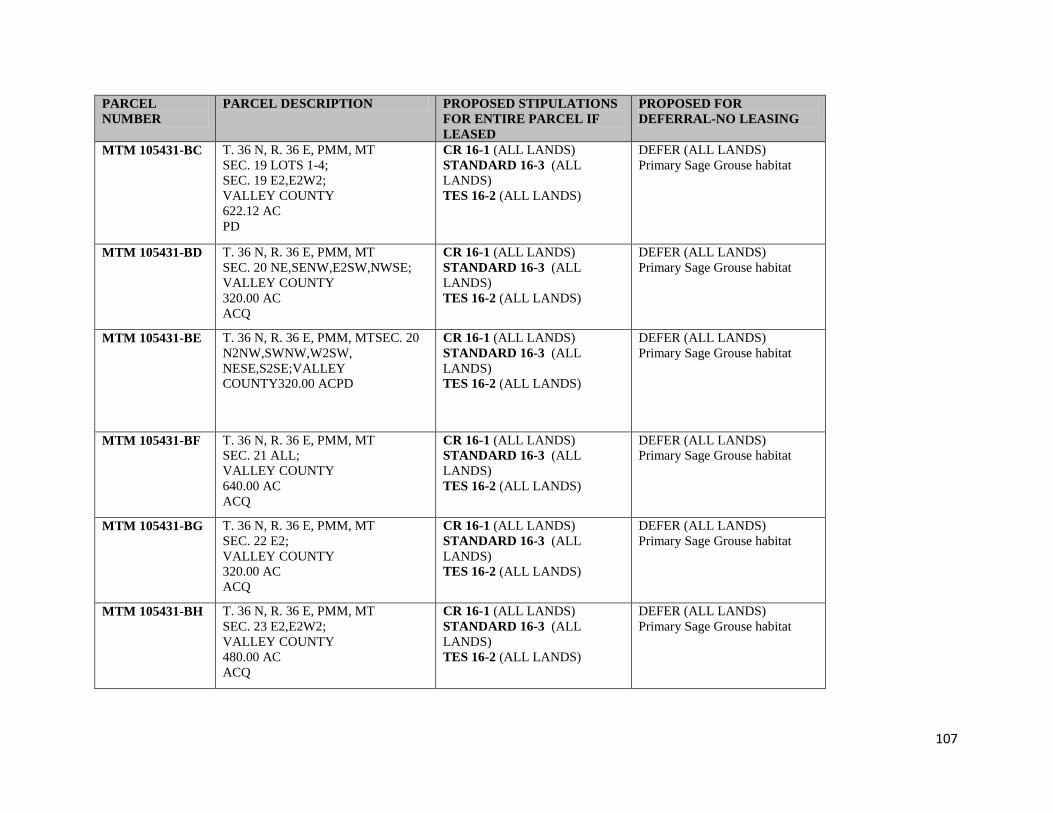
107
PARCEL
NUMBER
PARCEL DESCRIPTION PROPOSED STIPULATIONS
FOR ENTIRE PARCEL IF
LEASED
PROPOSED FOR
DEFERRAL-NO LEASING
MTM 105431-BC T. 36 N, R. 36 E, PMM, MT
SEC. 19 LOTS 1-4;
SEC. 19 E2,E2W2;
VALLEY COUNTY
622.12 AC
PD
CR 16-1 (ALL LANDS)
STANDARD 16-3 (ALL
LANDS)
TES 16-2 (ALL LANDS)
DEFER (ALL LANDS)
Primary Sage Grouse habitat
MTM 105431-BD T. 36 N, R. 36 E, PMM, MT
SEC. 20 NE,SENW,E2SW,NWSE;
VALLEY COUNTY
320.00 AC
ACQ
CR 16-1 (ALL LANDS)
STANDARD 16-3 (ALL
LANDS)
TES 16-2 (ALL LANDS)
DEFER (ALL LANDS)
Primary Sage Grouse habitat
MTM 105431-BE T. 36 N, R. 36 E, PMM, MTSEC. 20
N2NW,SWNW,W2SW,
NESE,S2SE;VALLEY
COUNTY320.00 ACPD
CR 16-1 (ALL LANDS)
STANDARD 16-3 (ALL
LANDS)
TES 16-2 (ALL LANDS)
DEFER (ALL LANDS)
Primary Sage Grouse habitat
MTM 105431-BF T. 36 N, R. 36 E, PMM, MT
SEC. 21 ALL;
VALLEY COUNTY
640.00 AC
ACQ
CR 16-1 (ALL LANDS)
STANDARD 16-3 (ALL
LANDS)
TES 16-2 (ALL LANDS)
DEFER (ALL LANDS)
Primary Sage Grouse habitat
MTM 105431-BG T. 36 N, R. 36 E, PMM, MT
SEC. 22 E2;
VALLEY COUNTY
320.00 AC
ACQ
CR 16-1 (ALL LANDS)
STANDARD 16-3 (ALL
LANDS)
TES 16-2 (ALL LANDS)
DEFER (ALL LANDS)
Primary Sage Grouse habitat
MTM 105431-BH T. 36 N, R. 36 E, PMM, MT
SEC. 23 E2,E2W2;
VALLEY COUNTY
480.00 AC
ACQ
CR 16-1 (ALL LANDS)
STANDARD 16-3 (ALL
LANDS)
TES 16-2 (ALL LANDS)
DEFER (ALL LANDS)
Primary Sage Grouse habitat

108
PARCEL
NUMBER
PARCEL DESCRIPTION PROPOSED STIPULATIONS
FOR ENTIRE PARCEL IF
LEASED
PROPOSED FOR
DEFERRAL-NO LEASING
MTM 105431-BJ T. 36 N, R. 36 E, PMM, MT
SEC. 24 S2N2,S2;
VALLEY COUNTY
480.00 AC
ACQ
CR 16-1 (ALL LANDS)
STANDARD 16-3 (ALL
LANDS)
TES 16-2 (ALL LANDS)
DEFER (ALL LANDS)
Primary Sage Grouse habitat
MTM 105431-BK T. 36 N, R. 36 E, PMM, MT
SEC. 25 N2NE,NW,NESW;
VALLEY COUNTY
280.00 AC
ACQ
CR 16-1 (ALL LANDS)
STANDARD 16-3 (ALL
LANDS)
TES 16-2 (ALL LANDS)
DEFER (ALL LANDS)
Primary Sage Grouse habitat
MTM 105431-BL T. 36 N, R. 36 E, PMM, MT
SEC. 25 NWSW,S2S2;
VALLEY COUNTY
200.00 AC
PD
CR 16-1 (ALL LANDS)
STANDARD 16-3 (ALL
LANDS)
TES 16-2 (ALL LANDS)
DEFER (ALL LANDS)
Primary Sage Grouse habitat
MTM 105431-BM T. 36 N, R. 36 E, PMM, MTSEC. 26
NENE,S2NE,S2;SEC. 27
E2SE;VALLEY COUNTY520.00
ACPD
CR 16-1 (ALL LANDS)
STANDARD 16-3 (ALL
LANDS)
TES 16-2 (ALL LANDS)
DEFER (ALL LANDS)
Primary Sage Grouse habitat
MTM 105431-BN T. 36 N, R. 36 E, PMM, MT
SEC. 26 NWNE,NW;
VALLEY COUNTY
200.00 AC
ACQ
CR 16-1 (ALL LANDS)
STANDARD 16-3 (ALL
LANDS)
TES 16-2 (ALL LANDS)
DEFER (ALL LANDS)
Primary Sage Grouse habitat
MTM 105431-BP T. 36 N, R. 36 E, PMM, MT
SEC. 27 N2,SW,W2SE;
VALLEY COUNTY
560.00 AC
ACQ
CR 16-1 (ALL LANDS)
STANDARD 16-3 (ALL
LANDS)
TES 16-2 (ALL LANDS)
DEFER (ALL LANDS)
Primary Sage Grouse habitat

109
PARCEL
NUMBER
PARCEL DESCRIPTION PROPOSED STIPULATIONS
FOR ENTIRE PARCEL IF
LEASED
PROPOSED FOR
DEFERRAL-NO LEASING
MTM 105431-BQ T. 36 N, R. 36 E, PMM, MT
SEC. 28 ALL;
VALLEY COUNTY
640.00 AC
ACQ
CR 16-1 (ALL LANDS)
STANDARD 16-3 (ALL
LANDS)
TES 16-2 (ALL LANDS)
DEFER (ALL LANDS)
Primary Sage Grouse habitat
MTM 105431-BR T. 36 N, R. 36 E, PMM, MT
SEC. 29 E2;
VALLEY COUNTY
320.00 AC
ACQ
CR 16-1 (ALL LANDS)
STANDARD 16-3 (ALL
LANDS)
TES 16-2 (ALL LANDS)
DEFER (ALL LANDS)
Primary Sage Grouse habitat
MTM 105431-BT T. 36 N, R. 36 E, PMM, MT
SEC. 29 W2;
VALLEY COUNTY
320.00 AC
PD
CR 16-1 (ALL LANDS)
STANDARD 16-3 (ALL
LANDS)
TES 16-2 (ALL LANDS)
DEFER (ALL LANDS)
Primary Sage Grouse habitat
MTM 105431-BU T. 36 N, R. 36 E, PMM, MT
SEC. 30 LOTS 1-4;
SEC. 30 E2,E2W2;
VALLEY COUNTY
623.60 AC
PD
CR 16-1 (ALL LANDS)
STANDARD 16-3 (ALL
LANDS)
TES 16-2 (ALL LANDS)
DEFER (ALL LANDS)
Primary Sage Grouse habitat
MTM 105431-BV T. 36 N, R. 36 E, PMM, MTSEC. 31
LOT 1;SEC. 31
NENE,S2NE,SE;VALLEY
COUNTY316.11 ACPD
CR 16-1 (ALL LANDS)
STANDARD 16-3 (ALL
LANDS)
TES 16-2 (ALL LANDS)
DEFER (ALL LANDS)
Primary Sage Grouse habitat
MTM 105431-BW T. 36 N, R. 36 E, PMM, MT
SEC. 32 ALL;
VALLEY COUNTY
640.00 AC
ACQ
CR 16-1 (ALL LANDS)
STANDARD 16-3 (ALL
LANDS)
TES 16-2 (ALL LANDS)
DEFER (ALL LANDS)
Primary Sage Grouse habitat

110
PARCEL
NUMBER
PARCEL DESCRIPTION PROPOSED STIPULATIONS
FOR ENTIRE PARCEL IF
LEASED
PROPOSED FOR
DEFERRAL-NO LEASING
MTM 105431-BX T. 36 N, R. 36 E, PMM, MT
SEC. 33 W2,E2SE;
VALLEY COUNTY
400.00 AC
ACQ
CR 16-1 (ALL LANDS)
STANDARD 16-3 (ALL
LANDS)
TES 16-2 (ALL LANDS)
DEFER (ALL LANDS)
Primary Sage Grouse habitat
MTM 105431-B3 T. 36 N, R. 36 E, PMM, MT
SEC. 34 E2NE,NESE;
SEC. 35 N2N2,SWNW;
VALLEY COUNTY
320.00 AC
PD
CR 16-1 (ALL LANDS)
STANDARD 16-3 (ALL
LANDS)
TES 16-2 (ALL LANDS)
DEFER (ALL LANDS)
Primary Sage Grouse habitat
MTM 105431-BY T. 36 N, R. 36 E, PMM, MT
SEC. 34 W2NE,W2,NWSE,S2SE;
VALLEY COUNTY
520.00 AC
ACQ
CR 16-1 (ALL LANDS)
STANDARD 16-3 (ALL
LANDS)
TES 16-2 (ALL LANDS)
DEFER (ALL LANDS)
Primary Sage Grouse habitat
MTM 105431-B4 T. 36 N, R. 36 E, PMM, MT
SEC. 35 S2NE,SENW;
VALLEY COUNTY
120.00 AC
ACQ
CR 16-1 (ALL LANDS)
STANDARD 16-3 (ALL
LANDS)
TES 16-2 (ALL LANDS)
DEFER (ALL LANDS)
Primary Sage Grouse habitat
MTM 105431-B6 T. 36 N, R. 36 E, PMM, MT
SEC. 35 S2;
VALLEY COUNTY
320.00 AC
98% U.S. MINERAL INTEREST 2/
ACQ
CR 16-1 (ALL LANDS)
STANDARD 16-3 (ALL
LANDS)
TES 16-2 (ALL LANDS)
DEFER (ALL LANDS)
Primary Sage Grouse habitat
MTM 105431-EA T. 37 N, R. 36 E, PMM, MTSEC. 5
LOTS 1,2;SEC. 5
S2NE,SE;VALLEY COUNTY333.56
ACACQ
CR 16-1 (ALL LANDS)
STANDARD 16-3 (ALL
LANDS)
TES 16-2 (ALL LANDS)
DEFER (ALL LANDS)
Primary Sage Grouse habitat
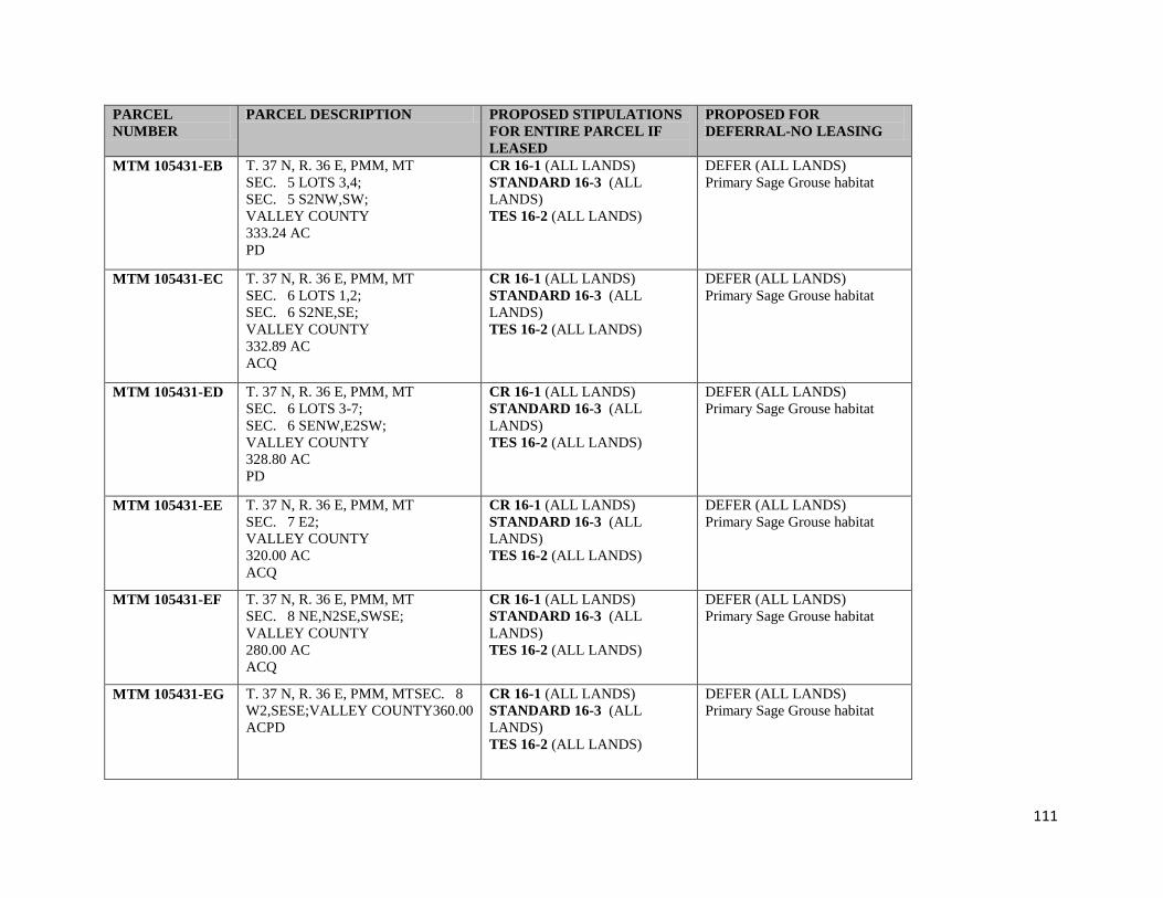
111
PARCEL
NUMBER
PARCEL DESCRIPTION PROPOSED STIPULATIONS
FOR ENTIRE PARCEL IF
LEASED
PROPOSED FOR
DEFERRAL-NO LEASING
MTM 105431-EB T. 37 N, R. 36 E, PMM, MT
SEC. 5 LOTS 3,4;
SEC. 5 S2NW,SW;
VALLEY COUNTY
333.24 AC
PD
CR 16-1 (ALL LANDS)
STANDARD 16-3 (ALL
LANDS)
TES 16-2 (ALL LANDS)
DEFER (ALL LANDS)
Primary Sage Grouse habitat
MTM 105431-EC T. 37 N, R. 36 E, PMM, MT
SEC. 6 LOTS 1,2;
SEC. 6 S2NE,SE;
VALLEY COUNTY
332.89 AC
ACQ
CR 16-1 (ALL LANDS)
STANDARD 16-3 (ALL
LANDS)
TES 16-2 (ALL LANDS)
DEFER (ALL LANDS)
Primary Sage Grouse habitat
MTM 105431-ED T. 37 N, R. 36 E, PMM, MT
SEC. 6 LOTS 3-7;
SEC. 6 SENW,E2SW;
VALLEY COUNTY
328.80 AC
PD
CR 16-1 (ALL LANDS)
STANDARD 16-3 (ALL
LANDS)
TES 16-2 (ALL LANDS)
DEFER (ALL LANDS)
Primary Sage Grouse habitat
MTM 105431-EE T. 37 N, R. 36 E, PMM, MT
SEC. 7 E2;
VALLEY COUNTY
320.00 AC
ACQ
CR 16-1 (ALL LANDS)
STANDARD 16-3 (ALL
LANDS)
TES 16-2 (ALL LANDS)
DEFER (ALL LANDS)
Primary Sage Grouse habitat
MTM 105431-EF T. 37 N, R. 36 E, PMM, MT
SEC. 8 NE,N2SE,SWSE;
VALLEY COUNTY
280.00 AC
ACQ
CR 16-1 (ALL LANDS)
STANDARD 16-3 (ALL
LANDS)
TES 16-2 (ALL LANDS)
DEFER (ALL LANDS)
Primary Sage Grouse habitat
MTM 105431-EG T. 37 N, R. 36 E, PMM, MTSEC. 8
W2,SESE;VALLEY COUNTY360.00
ACPD
CR 16-1 (ALL LANDS)
STANDARD 16-3 (ALL
LANDS)
TES 16-2 (ALL LANDS)
DEFER (ALL LANDS)
Primary Sage Grouse habitat

112
PARCEL
NUMBER
PARCEL DESCRIPTION PROPOSED STIPULATIONS
FOR ENTIRE PARCEL IF
LEASED
PROPOSED FOR
DEFERRAL-NO LEASING
MTM 105431-EH T. 37 N, R. 36 E, PMM, MT
SEC. 17 N2,N2SE;
SEC. 18 NENE;
VALLEY COUNTY
440.00 AC
PD
CR 16-1 (ALL LANDS)
STANDARD 16-3 (ALL
LANDS)
TES 16-2 (ALL LANDS)
DEFER (ALL LANDS)
Primary Sage Grouse habitat
MTM 105431-EJ T. 37 N, R. 36 E, PMM, MT
SEC. 17 SW,S2SE;
SEC. 20 N2NW;
VALLEY COUNTY
320.00 AC
ACQ
CR 16-1 (ALL LANDS)
STANDARD 16-3 (ALL
LANDS)
TES 16-2 (ALL LANDS)
DEFER (ALL LANDS)
Primary Sage Grouse habitat
MTM 105431-EK T. 37 N, R. 36 E, PMM, MT
SEC. 18 NWNE,S2NE,SE;
SEC. 19 NENE;
VALLEY COUNTY
320.00 AC
ACQ
CR 16-1 (ALL LANDS)
STANDARD 16-3 (ALL
LANDS)
TES 16-2 (ALL LANDS)
DEFER (ALL LANDS)
Primary Sage Grouse habitat
MTM 105431-EL T. 37 N, R. 36 E, PMM, MT
SEC. 19 LOT 4;
VALLEY COUNTY
39.99 AC
PD
CR 16-1 (ALL LANDS)
STANDARD 16-3 (ALL
LANDS)
TES 16-2 (ALL LANDS)
DEFER (ALL LANDS)
Primary Sage Grouse habitat
MTM 105431-EM T. 37 N, R. 36 E, PMM, MT
SEC. 19 SESE;
SEC. 20 SWSW;
SEC. 30 NE,N2SE;
VALLEY COUNTY
320.00 AC
ACQ
CR 16-1 (ALL LANDS)
STANDARD 16-3 (ALL
LANDS)
TES 16-2 (ALL LANDS)
DEFER (ALL LANDS)
Primary Sage Grouse habitat

113
PARCEL
NUMBER
PARCEL DESCRIPTION PROPOSED STIPULATIONS
FOR ENTIRE PARCEL IF
LEASED
PROPOSED FOR
DEFERRAL-NO LEASING
MTM 105431-EN T. 37 N, R. 36 E, PMM, MTSEC. 20
N2NE;VALLEY COUNTY80.00
ACPD
CR 16-1 (ALL LANDS)
STANDARD 16-3 (ALL
LANDS)
TES 16-2 (ALL LANDS)
DEFER (ALL LANDS)
Primary Sage Grouse habitat
MTM 105431-EP T. 37 N, R. 36 E, PMM, MT
SEC. 20 SESW,S2SE;
VALLEY COUNTY
120.00 AC
PD
CR 16-1 (ALL LANDS)
STANDARD 16-3 (ALL
LANDS)
TES 16-2 (ALL LANDS)
DEFER (ALL LANDS)
Primary Sage Grouse habitat
MTM 105431-EQ T. 37 N, R. 36 E, PMM, MT
SEC. 29 N2,W2SW,E2SE;
VALLEY COUNTY
480.00 AC
PD
CR 16-1 (ALL LANDS)
STANDARD 16-3 (ALL
LANDS)
TES 16-2 (ALL LANDS)
DEFER (ALL LANDS)
Primary Sage Grouse habitat
MTM 105431-ER T. 37 N, R. 36 E, PMM, MT
SEC. 29 E2SW,W2SE;
VALLEY COUNTY
160.00 AC
ACQ
CR 16-1 (ALL LANDS)
STANDARD 16-3 (ALL
LANDS)
TES 16-2 (ALL LANDS)
DEFER (ALL LANDS)
Primary Sage Grouse habitat
MTM 105431-ET T. 37 N, R. 36 E, PMM, MT
SEC. 30 LOTS 3,4;
VALLEY COUNTY
80.37 AC
PD
CR 16-1 (ALL LANDS)
STANDARD 16-3 (ALL
LANDS)
TES 16-2 (ALL LANDS)
DEFER (ALL LANDS)
Primary Sage Grouse habitat
MTM 105431-EU T. 37 N, R. 36 E, PMM, MT
SEC. 31 LOTS 1-4;
SEC. 31 E2,E2W2;
VALLEY COUNTY
640.48 AC
PD
CR 16-1 (ALL LANDS)
STANDARD 16-3 (ALL
LANDS)
TES 16-2 (ALL LANDS)
DEFER (ALL LANDS)
Primary Sage Grouse habitat

114
PARCEL
NUMBER
PARCEL DESCRIPTION PROPOSED STIPULATIONS
FOR ENTIRE PARCEL IF
LEASED
PROPOSED FOR
DEFERRAL-NO LEASING
MTM 105431-EV T. 37 N, R. 36 E, PMM, MT
SEC. 32 NWNW,S2NW,SW,NWSE;
VALLEY COUNTY
320.00 AC
PD
CR 16-1 (ALL LANDS)
STANDARD 16-3 (ALL
LANDS)
TES 16-2 (ALL LANDS)
DEFER (ALL LANDS)
Primary Sage Grouse habitat
MTM 105431-EW T. 37 N, R. 36 E, PMM, MTSEC. 33
E2NE,S2SW,SE;VALLEY
COUNTY320.00 ACACQ
CR 16-1 (ALL LANDS)
STANDARD 16-3 (ALL
LANDS)
TES 16-2 (ALL LANDS)
DEFER (ALL LANDS)
Primary Sage Grouse habitat
MTM 105431-EX T. 37 N, R. 36 E, PMM, MT
SEC. 33 W2NE,NW,N2SW;
VALLEY COUNTY
320.00 AC
PD
CR 16-1 (ALL LANDS)
STANDARD 16-3 (ALL
LANDS)
TES 16-2 (ALL LANDS)
DEFER (ALL LANDS)
Primary Sage Grouse habitat
MTM 105431-EY T. 37 N, R. 36 E, PMM, MT
SEC. 34 ALL;
VALLEY COUNTY
640.00 AC
ACQ
CR 16-1 (ALL LANDS)
STANDARD 16-3 (ALL
LANDS)
TES 16-2 (ALL LANDS)
DEFER (ALL LANDS)
Primary Sage Grouse habitat
MTM 105431-E3 T. 37 N, R. 36 E, PMM, MT
SEC. 35 ALL;
VALLEY COUNTY
640.00 AC
ACQ
CR 16-1 (ALL LANDS)
STANDARD 16-3 (ALL
LANDS)
TES 16-2 (ALL LANDS)
DEFER (ALL LANDS)
Primary Sage Grouse habitat
MTM 105431-E4 T. 37 N, R. 36 E, PMM, MT
SEC. 36 W2;
VALLEY COUNTY
320.00 AC
ACQ
CR 16-1 (ALL LANDS)
STANDARD 16-3 (ALL
LANDS)
TES 16-2 (ALL LANDS)
DEFER (ALL LANDS)
Primary Sage Grouse habitat
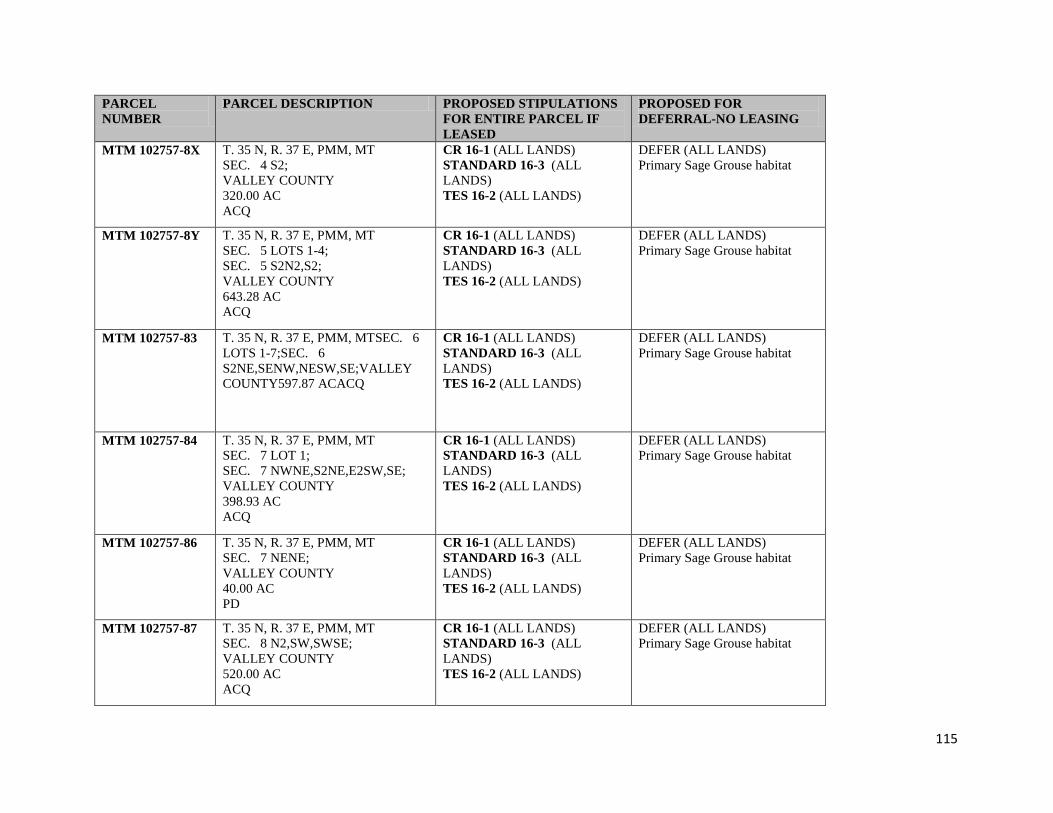
115
PARCEL
NUMBER
PARCEL DESCRIPTION PROPOSED STIPULATIONS
FOR ENTIRE PARCEL IF
LEASED
PROPOSED FOR
DEFERRAL-NO LEASING
MTM 102757-8X T. 35 N, R. 37 E, PMM, MT
SEC. 4 S2;
VALLEY COUNTY
320.00 AC
ACQ
CR 16-1 (ALL LANDS)
STANDARD 16-3 (ALL
LANDS)
TES 16-2 (ALL LANDS)
DEFER (ALL LANDS)
Primary Sage Grouse habitat
MTM 102757-8Y T. 35 N, R. 37 E, PMM, MT
SEC. 5 LOTS 1-4;
SEC. 5 S2N2,S2;
VALLEY COUNTY
643.28 AC
ACQ
CR 16-1 (ALL LANDS)
STANDARD 16-3 (ALL
LANDS)
TES 16-2 (ALL LANDS)
DEFER (ALL LANDS)
Primary Sage Grouse habitat
MTM 102757-83 T. 35 N, R. 37 E, PMM, MTSEC. 6
LOTS 1-7;SEC. 6
S2NE,SENW,NESW,SE;VALLEY
COUNTY597.87 ACACQ
CR 16-1 (ALL LANDS)
STANDARD 16-3 (ALL
LANDS)
TES 16-2 (ALL LANDS)
DEFER (ALL LANDS)
Primary Sage Grouse habitat
MTM 102757-84 T. 35 N, R. 37 E, PMM, MT
SEC. 7 LOT 1;
SEC. 7 NWNE,S2NE,E2SW,SE;
VALLEY COUNTY
398.93 AC
ACQ
CR 16-1 (ALL LANDS)
STANDARD 16-3 (ALL
LANDS)
TES 16-2 (ALL LANDS)
DEFER (ALL LANDS)
Primary Sage Grouse habitat
MTM 102757-86 T. 35 N, R. 37 E, PMM, MT
SEC. 7 NENE;
VALLEY COUNTY
40.00 AC
PD
CR 16-1 (ALL LANDS)
STANDARD 16-3 (ALL
LANDS)
TES 16-2 (ALL LANDS)
DEFER (ALL LANDS)
Primary Sage Grouse habitat
MTM 102757-87 T. 35 N, R. 37 E, PMM, MT
SEC. 8 N2,SW,SWSE;
VALLEY COUNTY
520.00 AC
ACQ
CR 16-1 (ALL LANDS)
STANDARD 16-3 (ALL
LANDS)
TES 16-2 (ALL LANDS)
DEFER (ALL LANDS)
Primary Sage Grouse habitat

116
PARCEL
NUMBER
PARCEL DESCRIPTION PROPOSED STIPULATIONS
FOR ENTIRE PARCEL IF
LEASED
PROPOSED FOR
DEFERRAL-NO LEASING
MTM 102757-88 T. 35 N, R. 37 E, PMM, MT
SEC. 9 N2NE,E2SE;
SEC. 10 W2;
VALLEY COUNTY
480.00 AC
PD
CR 16-1 (ALL LANDS)
STANDARD 16-3 (ALL
LANDS)
TES 16-2 (ALL LANDS)
DEFER (ALL LANDS)
Primary Sage Grouse habitat
MTM 102757-89 T. 35 N, R. 37 E, PMM, MT
SEC. 11 SW;
VALLEY COUNTY
160.00 AC
ACQ
CR 16-1 (ALL LANDS)
STANDARD 16-3 (ALL
LANDS)
TES 16-2 (ALL LANDS)
DEFER (ALL LANDS)
Primary Sage Grouse habitat
MTM 102757-9A T. 35 N, R. 37 E, PMM, MT
SEC. 11 SE;
VALLEY COUNTY
160.00 AC
PD
CR 16-1 (ALL LANDS)
STANDARD 16-3 (ALL
LANDS)
TES 16-2 (ALL LANDS)
DEFER (ALL LANDS)
Primary Sage Grouse habitat
MTM 102757-9B T. 35 N, R. 37 E, PMM, MTSEC. 14
N2NE,NW,W2SW;VALLEY
COUNTY320.00 ACPD
CR 16-1 (ALL LANDS)
STANDARD 16-3 (ALL
LANDS)
TES 16-2 (ALL LANDS)
DEFER (ALL LANDS)
Primary Sage Grouse habitat
MTM 102757-9C T. 35 N, R. 37 E, PMM, MT
SEC. 14 S2NE,E2SW,SE;
VALLEY COUNTY
320.00 AC
ACQ
CR 16-1 (ALL LANDS)
STANDARD 16-3 (ALL
LANDS)
TES 16-2 (ALL LANDS)
DEFER (ALL LANDS)
Primary Sage Grouse habitat
MTM 102757-9D T. 35 N, R. 37 E, PMM, MT
SEC. 15 E2,N2NW,SENW,NESW,
S2SW;
VALLEY COUNTY
560.00 AC
ACQ
CR 16-1 (ALL LANDS)
STANDARD 16-3 (ALL
LANDS)
TES 16-2 (ALL LANDS)
DEFER (ALL LANDS)
Primary Sage Grouse habitat
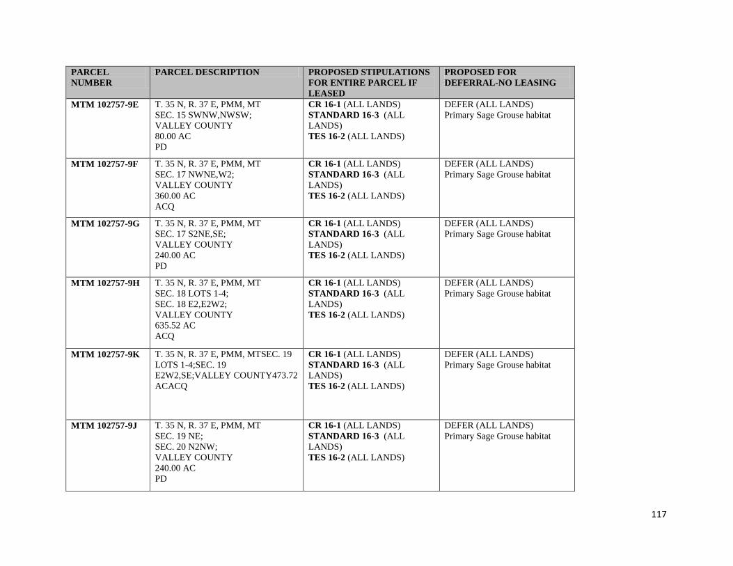
117
PARCEL
NUMBER
PARCEL DESCRIPTION PROPOSED STIPULATIONS
FOR ENTIRE PARCEL IF
LEASED
PROPOSED FOR
DEFERRAL-NO LEASING
MTM 102757-9E T. 35 N, R. 37 E, PMM, MT
SEC. 15 SWNW,NWSW;
VALLEY COUNTY
80.00 AC
PD
CR 16-1 (ALL LANDS)
STANDARD 16-3 (ALL
LANDS)
TES 16-2 (ALL LANDS)
DEFER (ALL LANDS)
Primary Sage Grouse habitat
MTM 102757-9F T. 35 N, R. 37 E, PMM, MT
SEC. 17 NWNE,W2;
VALLEY COUNTY
360.00 AC
ACQ
CR 16-1 (ALL LANDS)
STANDARD 16-3 (ALL
LANDS)
TES 16-2 (ALL LANDS)
DEFER (ALL LANDS)
Primary Sage Grouse habitat
MTM 102757-9G T. 35 N, R. 37 E, PMM, MT
SEC. 17 S2NE,SE;
VALLEY COUNTY
240.00 AC
PD
CR 16-1 (ALL LANDS)
STANDARD 16-3 (ALL
LANDS)
TES 16-2 (ALL LANDS)
DEFER (ALL LANDS)
Primary Sage Grouse habitat
MTM 102757-9H T. 35 N, R. 37 E, PMM, MT
SEC. 18 LOTS 1-4;
SEC. 18 E2,E2W2;
VALLEY COUNTY
635.52 AC
ACQ
CR 16-1 (ALL LANDS)
STANDARD 16-3 (ALL
LANDS)
TES 16-2 (ALL LANDS)
DEFER (ALL LANDS)
Primary Sage Grouse habitat
MTM 102757-9K T. 35 N, R. 37 E, PMM, MTSEC. 19
LOTS 1-4;SEC. 19
E2W2,SE;VALLEY COUNTY473.72
ACACQ
CR 16-1 (ALL LANDS)
STANDARD 16-3 (ALL
LANDS)
TES 16-2 (ALL LANDS)
DEFER (ALL LANDS)
Primary Sage Grouse habitat
MTM 102757-9J T. 35 N, R. 37 E, PMM, MT
SEC. 19 NE;
SEC. 20 N2NW;
VALLEY COUNTY
240.00 AC
PD
CR 16-1 (ALL LANDS)
STANDARD 16-3 (ALL
LANDS)
TES 16-2 (ALL LANDS)
DEFER (ALL LANDS)
Primary Sage Grouse habitat

118
PARCEL
NUMBER
PARCEL DESCRIPTION PROPOSED STIPULATIONS
FOR ENTIRE PARCEL IF
LEASED
PROPOSED FOR
DEFERRAL-NO LEASING
MTM 102757-9L T. 35 N, R. 37 E, PMM, MT
SEC. 20 N2NE,SENE,E2SE;
VALLEY COUNTY
200.00 AC
PD
CR 16-1 (ALL LANDS)
STANDARD 16-3 (ALL
LANDS)
TES 16-2 (ALL LANDS)
DEFER (ALL LANDS)
Primary Sage Grouse habitat
MTM 102757-9M T. 35 N, R. 37 E, PMM, MT
SEC. 21 N2N2,SENE,SWNW,
NESE,S2SE;
VALLEY COUNTY
360.00 AC
ACQ
CR 16-1 (ALL LANDS)
STANDARD 16-3 (ALL
LANDS)
TES 16-2 (ALL LANDS)
DEFER (ALL LANDS)
Primary Sage Grouse habitat
MTM 102757-9N T. 35 N, R. 37 E, PMM, MT
SEC. 21 NWSW,S2SW;
VALLEY COUNTY
120.00 AC
PD
CR 16-1 (ALL LANDS)
STANDARD 16-3 (ALL
LANDS)
TES 16-2 (ALL LANDS)
DEFER (ALL LANDS)
Primary Sage Grouse habitat
MTM 102757-9P T. 35 N, R. 37 E, PMM, MT
SEC. 22 E2,S2SW;
SEC. 23 W2W2;
VALLEY COUNTY
560.00 AC
PD
CR 16-1 (ALL LANDS)
STANDARD 16-3 (ALL
LANDS)
TES 16-2 (ALL LANDS)
DEFER (ALL LANDS)
Primary Sage Grouse habitat
MTM 102757-9Q T. 35 N, R. 37 E, PMM, MTSEC. 22
NW,N2SW;VALLEY
COUNTY240.00 ACACQ
CR 16-1 (ALL LANDS)
STANDARD 16-3 (ALL
LANDS)
TES 16-2 (ALL LANDS)
DEFER (ALL LANDS)
Primary Sage Grouse habitat
MTM 102757-9R T. 35 N, R. 37 E, PMM, MT
SEC. 23 E2,E2W2;
VALLEY COUNTY
480.00 AC
ACQ
CR 16-1 (ALL LANDS)
STANDARD 16-3 (ALL
LANDS)
TES 16-2 (ALL LANDS)
DEFER (ALL LANDS)
Primary Sage Grouse habitat
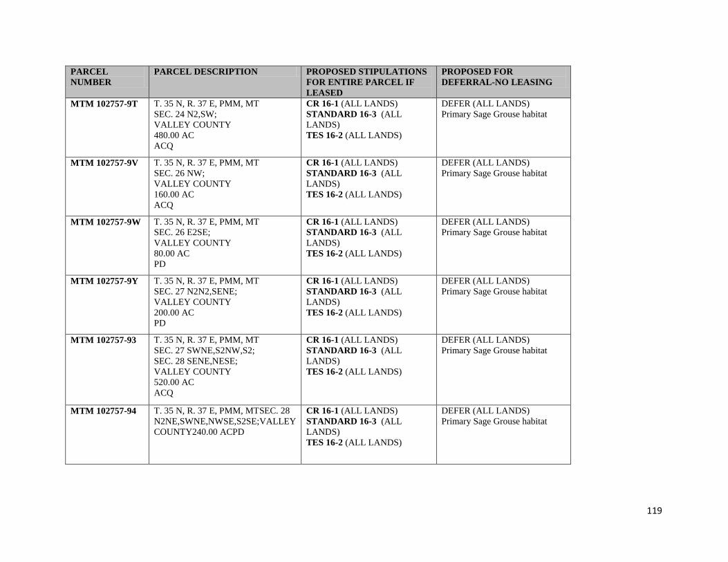
119
PARCEL
NUMBER
PARCEL DESCRIPTION PROPOSED STIPULATIONS
FOR ENTIRE PARCEL IF
LEASED
PROPOSED FOR
DEFERRAL-NO LEASING
MTM 102757-9T T. 35 N, R. 37 E, PMM, MT
SEC. 24 N2,SW;
VALLEY COUNTY
480.00 AC
ACQ
CR 16-1 (ALL LANDS)
STANDARD 16-3 (ALL
LANDS)
TES 16-2 (ALL LANDS)
DEFER (ALL LANDS)
Primary Sage Grouse habitat
MTM 102757-9V T. 35 N, R. 37 E, PMM, MT
SEC. 26 NW;
VALLEY COUNTY
160.00 AC
ACQ
CR 16-1 (ALL LANDS)
STANDARD 16-3 (ALL
LANDS)
TES 16-2 (ALL LANDS)
DEFER (ALL LANDS)
Primary Sage Grouse habitat
MTM 102757-9W T. 35 N, R. 37 E, PMM, MT
SEC. 26 E2SE;
VALLEY COUNTY
80.00 AC
PD
CR 16-1 (ALL LANDS)
STANDARD 16-3 (ALL
LANDS)
TES 16-2 (ALL LANDS)
DEFER (ALL LANDS)
Primary Sage Grouse habitat
MTM 102757-9Y T. 35 N, R. 37 E, PMM, MT
SEC. 27 N2N2,SENE;
VALLEY COUNTY
200.00 AC
PD
CR 16-1 (ALL LANDS)
STANDARD 16-3 (ALL
LANDS)
TES 16-2 (ALL LANDS)
DEFER (ALL LANDS)
Primary Sage Grouse habitat
MTM 102757-93 T. 35 N, R. 37 E, PMM, MT
SEC. 27 SWNE,S2NW,S2;
SEC. 28 SENE,NESE;
VALLEY COUNTY
520.00 AC
ACQ
CR 16-1 (ALL LANDS)
STANDARD 16-3 (ALL
LANDS)
TES 16-2 (ALL LANDS)
DEFER (ALL LANDS)
Primary Sage Grouse habitat
MTM 102757-94 T. 35 N, R. 37 E, PMM, MTSEC. 28
N2NE,SWNE,NWSE,S2SE;VALLEY
COUNTY240.00 ACPD
CR 16-1 (ALL LANDS)
STANDARD 16-3 (ALL
LANDS)
TES 16-2 (ALL LANDS)
DEFER (ALL LANDS)
Primary Sage Grouse habitat

120
PARCEL
NUMBER
PARCEL DESCRIPTION PROPOSED STIPULATIONS
FOR ENTIRE PARCEL IF
LEASED
PROPOSED FOR
DEFERRAL-NO LEASING
MTM 102757-96 T. 35 N, R. 37 E, PMM, MT
SEC. 28 W2;
VALLEY COUNTY
320.00 AC
ACQ
CR 16-1 (ALL LANDS)
STANDARD 16-3 (ALL
LANDS)
TES 16-2 (ALL LANDS)
DEFER (ALL LANDS)
Primary Sage Grouse habitat
MTM 102757-97 T. 35 N, R. 37 E, PMM, MT
SEC. 29 NE,E2NW,S2;
VALLEY COUNTY
560.00 AC
PD
CR 16-1 (ALL LANDS)
STANDARD 16-3 (ALL
LANDS)
TES 16-2 (ALL LANDS)
DEFER (ALL LANDS)
Primary Sage Grouse habitat
MTM 102757-98 T. 35 N, R. 37 E, PMM, MT
SEC. 29 W2NW;
VALLEY COUNTY
80.00 AC
ACQ
CR 16-1 (ALL LANDS)
STANDARD 16-3 (ALL
LANDS)
TES 16-2 (ALL LANDS)
DEFER (ALL LANDS)
Primary Sage Grouse habitat
MTM 105431-B7 T. 36 N, R. 37 E, PMM, MT
SEC. 5 LOTS 1,4;
SEC. 5 N2SW,SESW,NESE;
VALLEY COUNTY
236.38 AC
ACQ
CR 16-1 (ALL LANDS)
STANDARD 16-3 (ALL
LANDS)
TES 16-2 (ALL LANDS)
DEFER (ALL LANDS)
Primary Sage Grouse habitat
MTM 105431-B8 T. 36 N, R. 37 E, PMM, MT
SEC. 6 LOTS 1-6;
SEC. 6 NESW,N2SE;
VALLEY COUNTY
350.73 AC
ACQ
CR 16-1 (ALL LANDS)
STANDARD 16-3 (ALL
LANDS)
TES 16-2 (ALL LANDS)
DEFER (ALL LANDS)
Primary Sage Grouse habitat
MTM 105431-B9 T. 36 N, R. 37 E, PMM, MT
SEC. 7 LOTS 1-4;
SEC. 7 SESW,S2SE;
VALLEY COUNTY
276.04 AC
ACQ
CR 16-1 (ALL LANDS)
STANDARD 16-3 (ALL
LANDS)
TES 16-2 (ALL LANDS)
DEFER (ALL LANDS)
Primary Sage Grouse habitat

121
PARCEL
NUMBER
PARCEL DESCRIPTION PROPOSED STIPULATIONS
FOR ENTIRE PARCEL IF
LEASED
PROPOSED FOR
DEFERRAL-NO LEASING
MTM 105431-CA T. 36 N, R. 37 E, PMM, MTSEC. 8
E2NW,SW;VALLEY
COUNTY240.00 ACACQ
CR 16-1 (ALL LANDS)
STANDARD 16-3 (ALL
LANDS)
TES 16-2 (ALL LANDS)
DEFER (ALL LANDS)
Primary Sage Grouse habitat
MTM 105431-CB T. 36 N, R. 37 E, PMM, MT
SEC. 14 E2SW;
VALLEY COUNTY
80.00 AC
ACQ
CR 16-1 (ALL LANDS)
STANDARD 16-3 (ALL
LANDS)
TES 16-2 (ALL LANDS)
DEFER (ALL LANDS)
Primary Sage Grouse habitat
MTM 105431-CC T. 36 N, R. 37 E, PMM, MT
SEC. 17 NW;
VALLEY COUNTY
160.00 AC
ACQ
CR 16-1 (ALL LANDS)
STANDARD 16-3 (ALL
LANDS)
TES 16-2 (ALL LANDS)
DEFER (ALL LANDS)
Primary Sage Grouse habitat
MTM 105431-CD T. 36 N, R. 37 E, PMM, MT
SEC. 18 SESE EXCL 2.28 AC IN
CEMETARY DESC BY
M&B; 1/
SEC. 18 LOTS 1,3,4;
SEC. 18 NE,E2W2,N2SE,SWSE;
VALLEY COUNTY
595.28 AC
ACQ
CR 16-1 (ALL LANDS)
STANDARD 16-3 (ALL
LANDS)
TES 16-2 (ALL LANDS)
DEFER (ALL LANDS)
Primary Sage Grouse habitat
MTM 105431-CE T. 36 N, R. 37 E, PMM, MT
SEC. 19 LOTS 1-4;
SEC. 19 NE,E2W2;
VALLEY COUNTY
477.40 AC
ACQ
CR 16-1 (ALL LANDS)
STANDARD 16-3 (ALL
LANDS)
TES 16-2 (ALL LANDS)
DEFER (ALL LANDS)
Primary Sage Grouse habitat

122
PARCEL
NUMBER
PARCEL DESCRIPTION PROPOSED STIPULATIONS
FOR ENTIRE PARCEL IF
LEASED
PROPOSED FOR
DEFERRAL-NO LEASING
MTM 105431-CF T. 36 N, R. 37 E, PMM, MT
SEC. 20 N2,SW,N2SE;
VALLEY COUNTY
560.00 AC
ACQ
CR 16-1 (ALL LANDS)
STANDARD 16-3 (ALL
LANDS)
TES 16-2 (ALL LANDS)
DEFER (ALL LANDS)
Primary Sage Grouse habitat
MTM 105431-CG T. 36 N, R. 37 E, PMM, MTSEC. 29
S2NE,NW,S2;VALLEY
COUNTY560.00 ACACQ
CR 16-1 (ALL LANDS)
STANDARD 16-3 (ALL
LANDS)
TES 16-2 (ALL LANDS)
DEFER (ALL LANDS)
Primary Sage Grouse habitat
MTM 105431-CH T. 36 N, R. 37 E, PMM, MT
SEC. 30 LOTS 1,2;
SEC. 30 E2,E2NW;
VALLEY COUNTY
479.05 AC
ACQ
CR 16-1 (ALL LANDS)
STANDARD 16-3 (ALL
LANDS)
TES 16-2 (ALL LANDS)
DEFER (ALL LANDS)
Primary Sage Grouse habitat
MTM 105431-CJ T. 36 N, R. 37 E, PMM, MT
SEC. 31 LOTS 1-4;
SEC. 31 E2,E2W2;
VALLEY COUNTY
639.24 AC
ACQ
CR 16-1 (ALL LANDS)
STANDARD 16-3 (ALL
LANDS)
TES 16-2 (ALL LANDS)
DEFER (ALL LANDS)
Primary Sage Grouse habitat
MTM 105431-CK T. 36 N, R. 37 E, PMM, MT
SEC. 32 ALL;
VALLEY COUNTY
640.00 AC
ACQ
CR 16-1 (ALL LANDS)
STANDARD 16-3 (ALL
LANDS)
TES 16-2 (ALL LANDS)
DEFER (ALL LANDS)
Primary Sage Grouse habitat
MTM 102757-6J T. 34 N, R. 40 E, PMM, MT
SEC. 4 LOT 1;
SEC. 4 SENE;
VALLEY COUNTY
80.15 AC
ACQ
CR 16-1 (ALL LANDS)
STANDARD 16-3 (ALL
LANDS)
TES 16-2 (ALL LANDS)
123
PARCEL
NUMBER
PARCEL DESCRIPTION PROPOSED STIPULATIONS
FOR ENTIRE PARCEL IF
LEASED
PROPOSED FOR
DEFERRAL-NO LEASING
MTM 102757-6K T. 34 N, R. 40 E, PMM, MT
SEC. 4 S2SW;
SEC. 9 NW,N2SW;
VALLEY COUNTY
320.00 AC
ACQ
CR 16-1 (ALL LANDS)
STANDARD 16-3 (ALL
LANDS)
TES 16-2 (ALL LANDS)
DEFER (ALL LANDS)
Primary Spragues Pipit habitat
MTM 102757-6L T. 34 N, R. 40 E, PMM, MT
SEC. 11 S2;
VALLEY COUNTY
320.00 AC
ACQ
CR 16-1 (ALL LANDS)
STANDARD 16-3 (ALL
LANDS)
TES 16-2 (ALL LANDS)
MTM 102757-6M T. 35 N, R. 40 E, PMM, MT
SEC. 27 W2NE,E2SW,N2SE,SWSE;
SEC. 34 NENW;
VALLEY COUNTY
320.00 AC
ACQ
CR 16-1 (ALL LANDS)
STANDARD 16-3 (ALL
LANDS)
TES 16-2 (ALL LANDS)
DEFER (ALL LANDS)
Primary Spragues Pipit habitat
MTM 102757-6N T. 35 N, R. 40 E, PMM, MT
SEC. 33 SESW;
SEC. 34 W2NE,SESE;
VALLEY COUNTY
160.00 AC
PD
CR 16-1 (ALL LANDS)
STANDARD 16-3 (ALL
LANDS)
TES 16-2 (ALL LANDS)
MTM 102757-6P T. 35 N, R. 40 E, PMM, MT
SEC. 35 SWNE,SENW,E2SW,SE;
VALLEY COUNTY
320.00 AC
50% U.S. MINERAL INTEREST 2/
ACQ
CR 16-1 (ALL LANDS)
STANDARD 16-3 (ALL
LANDS)
TES 16-2 (ALL LANDS)

124
Appendix B. Lease Stipulation Key
Stipulation
Number
Stipulation Name/Brief Description
Bureau of Land Management
Cultural Resources
16-1
CULTURAL RESOURCES LEASE STIPULATION
This lease may be found to contain historic properties and/or resources protected
under the National Historic Preservation Act (NHPA), American Indian Religious
Freedom Act, Native American Graves Protection and Repatriation Act, E.O.
13007, or other statutes and executive orders. The BLM will not approve any
ground disturbing activities that may affect any such properties or resources until it
completes its obligations under applicable requirements of the NHPA and other
authorities. The BLM may require modification to exploration or development
proposals to protect such properties, or disapprove any activity that is likely to
result in adverse effects that cannot be successfully avoided, minimized or
mitigated."
Standard 16-3 STANDARD LEASE STIPULATION
ESTHETICS--To maintain esthetic values, all surface-disturbing activities,
semipermanent and permanent facilities may require special design including
location, painting and camouflage to blend with the natural surroundings and meet
the intent of the visual quality objectives of the Federal Surface Managing Agency
(SMA).
EROSION CONTROL--Surface-disturbing activities may be prohibited during
muddy and/or wet soil periods.
CONTROLLED OR LIMITED SURFACE USE STIPULATION --This
stipulation may be modified, consistent with land use documents, when specifically
approved in writing by the Bureau of Land Management (BLM) with concurrence
of the SMA. Distances and/or time periods may be made less restrictive depending
on the actual on ground conditions. The prospective lessee should contact the
SMA for more specific locations and information regarding the restrictive nature of
this stipulation.
The lessee/operator is given notice that the lands within this lease may include
special areas and that such areas may contain special values, may be needed for
special purposes, or may require special attention to prevent damage to surface
and/or other resources. Possible special areas are identified below. Any surface
use or occupancy within such special areas will be strictly controlled, or if
absolutely necessary, excluded. Use or occupancy will be restricted only when
the BLM and/or the SMA demonstrates the restriction necessary for the protection
of such special areas and existing or planned uses. Appropriate modifications to
imposed restrictions will be made for the maintenance and operations of producing
oil and gas wells.
After the SMA has been advised of specific proposed surface use or occupancy on

125
Stipulation
Number
Stipulation Name/Brief Description
the leased lands, and on request of the lessee/operator, the Agency will furnish
further data on any special areas which may include:
100 feet from the edge of the rights-of-way from highways, designated
county roads and appropriate federally-owned or controlled roads and
recreation trails.
500 feet, or when necessary, within the 25-year flood plain from
reservoirs, lakes, and ponds and intermittent, ephemeral or small perennial
streams: 1,000 feet, or when necessary, within the 100-year flood plain
from larger perennial streams, rivers, and domestic water supplies.
500 feet from grouse strutting grounds. Special care to avoid nesting areas
associated with strutting grounds will be necessary during the period from
March 1, to June 30. One-fourth mile from identified essential habitat of
state and federal sensitive species. Crucial wildlife winter ranges during
the period from December 1 to May 15, and in elk calving areas during the
period from May 1 to June 30.
300 feet from occupied buildings, developed recreational areas,
undeveloped recreational areas receiving concentrated public use and sites
eligible for or designated as National Register sites.
Seasonal road closures, roads for special uses, specified roads during
heavy traffic periods and on areas having restrictive off-road vehicle
designations.
On slopes over 30 percent or 20 percent on extremely erodible or
slumping soils.
APPLICATIONS FOR PERMIT TO DRILL (APDs)--The appropriate BLM
field offices are responsible for the receipt, processing, and approval of APDs. The
APDs are to be submitted by oil and gas operators pursuant to the requirements
found in Onshore Oil and Gas Order No. 1 -- Approval of Operations on Onshore
Federal and Indian Oil and Gas Leases (Circular No. 2538). Additional
requirements for the conduct of oil and gas operations can be found in the Code of
Federal Regulations Title 43, Part 3160. Copies of Onshore Oil and Gas Order No.
1, and pertinent regulations, can be obtained from the BLM field offices in which
the operations are proposed. Early coordination with these offices on proposals is
encouraged.
CULTURAL AND PALEONTOLOGICAL RESOURCES--The SMA is
responsible for assuring that the leased lands are examined to determine if cultural
resources are present and to specify mitigation measures. Prior to undertaking any
surface-disturbing activities on the lands covered by this lease, the lessee or
operator, unless notified to the contrary by the SMA, shall:
Contact the appropriate SMA to determine if a site-specific cultural
resource inventory is required. If an inventory is required, then:
Engage the services of a cultural resource specialist acceptable to the
SMA to conduct a cultural resource inventory of the area of proposed
surface disturbance. The operator may elect to inventory an area larger
than the area of proposed disturbance to cover possible site relocation
which may result from environmental or other considerations. An
acceptable inventory report is to be submitted to the SMA for review and
approval no later than that time when an otherwise complete application
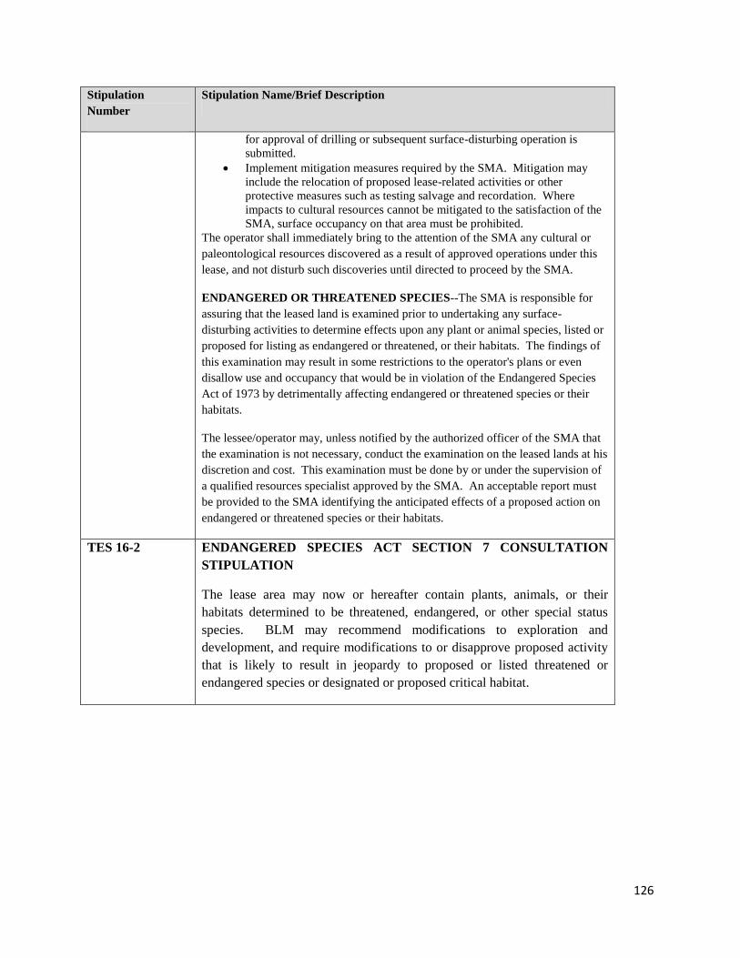
126
Stipulation
Number
Stipulation Name/Brief Description
for approval of drilling or subsequent surface-disturbing operation is
submitted.
Implement mitigation measures required by the SMA. Mitigation may
include the relocation of proposed lease-related activities or other
protective measures such as testing salvage and recordation. Where
impacts to cultural resources cannot be mitigated to the satisfaction of the
SMA, surface occupancy on that area must be prohibited.
The operator shall immediately bring to the attention of the SMA any cultural or
paleontological resources discovered as a result of approved operations under this
lease, and not disturb such discoveries until directed to proceed by the SMA.
ENDANGERED OR THREATENED SPECIES--The SMA is responsible for
assuring that the leased land is examined prior to undertaking any surface-
disturbing activities to determine effects upon any plant or animal species, listed or
proposed for listing as endangered or threatened, or their habitats. The findings of
this examination may result in some restrictions to the operator's plans or even
disallow use and occupancy that would be in violation of the Endangered Species
Act of 1973 by detrimentally affecting endangered or threatened species or their
habitats.
The lessee/operator may, unless notified by the authorized officer of the SMA that
the examination is not necessary, conduct the examination on the leased lands at his
discretion and cost. This examination must be done by or under the supervision of
a qualified resources specialist approved by the SMA. An acceptable report must
be provided to the SMA identifying the anticipated effects of a proposed action on
endangered or threatened species or their habitats.
TES 16-2 ENDANGERED SPECIES ACT SECTION 7 CONSULTATION
STIPULATION
The lease area may now or hereafter contain plants, animals, or their
habitats determined to be threatened, endangered, or other special status
species. BLM may recommend modifications to exploration and
development, and require modifications to or disapprove proposed activity
that is likely to result in jeopardy to proposed or listed threatened or
endangered species or designated or proposed critical habitat.

127
Appendix C. Maps.
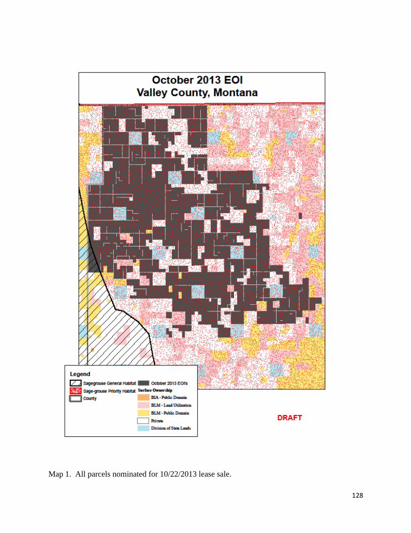
128
Map 1. All parcels nominated for 10/22/2013 lease sale.
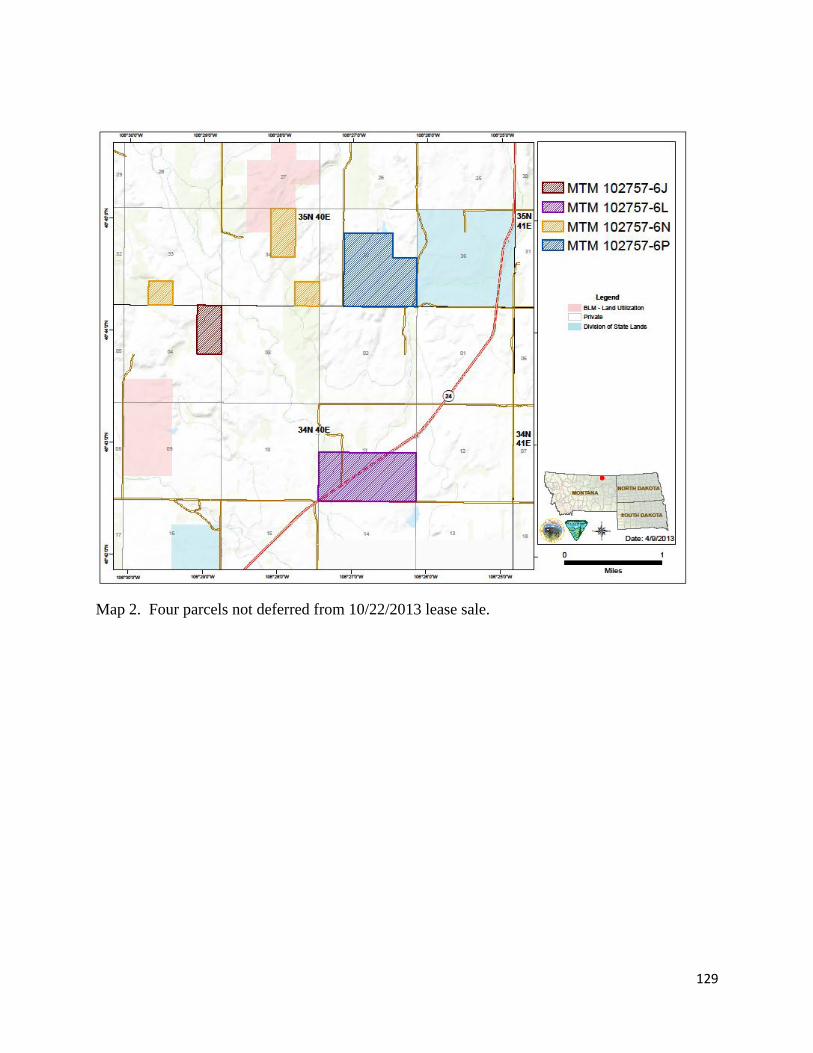
129
Map 2. Four parcels not deferred from 10/22/2013 lease sale.

130
Appendix D: National Wetland Inventory Data, National Hydrography Dataset, and
Geologic Map Information for Lease Area Parcels. (Source: USFWS, USGS & EPA, and
MBMG).
Parcel Location Description National Wetland
Inventory National Hydrography Dataset
MTBMG Geologic Map
MTM 102757-6J
T.34N., R.40E., sec.4 E1/2NE
No wetlands present. 0.332 miles of an Unnamed Tributary to the Middle Fork of Porcupine Creek
Kfh
MTM 102757-6L
Kb , Kfh , Qsg
T.34N., R.40E., sec.11 S1/2
0.911 miles of Alkali C reek
T.34N., R.40E., sec.11 NENWSE
0.095 miles of an Unnamed Tributary to Alkali Creek
T.34N., R.40E., sec.11 W1/2SW 0.972 acres of PABF
0.523 miles of the Middle Fork of Porcupine Creek
MTM 102757-6N
Khc, Qsg , Kfh
T.35N., R.40E., sec.34 NWNWNE 0.197 acres of PABFh
0.106 miles of an Unnamed Tributary to the Middle Fork of Porcupine Creek
T.35N., R.40E., sec.34 SESWNE
0.131 miles of an Unnamed Tributary to the Middle Fork of Porcupine Creek
T.35N., R.40E., sec.34 N1/2SESE
0.268 miles of an Unnamed Tributary to the Middle Fork of Porcupine Creek
T.35N., R.40E., sec.34 NWSESE
0.357 acres of PABFh
T.35N., R.40E., sec.33 N1/2SESW
0.225 miles of an Unnamed Tributary to the Middle Fork of Porcupine Creek
MTM 102757-6P
Tsg , Tfu , Qsg , Khc
T.35N., R.40E., sec.35 NESWNE 1.13 acres of PABFh
0.116 miles of an Unnamed Tributary to Alkali Creek
T.35N., R.40E., sec.35 E1/2SE
0.462 miles of an Unnamed Tributary to Alkali Creek
T.35N., R.40E., sec.35 E1/2SENW 0.152 acres of PEMA