unit 5: t nfip floodplain management requirements · unit 5: the nfip floodplain management...
TRANSCRIPT
UNIT 5: THE NFIP FLOODPLAIN MANAGEMENT REQUIREMENTS
In this unit This unit reviews the NFIP standards for floodplain development,
including:
♦ What maps, base flood elevations and other flood data must be used,
♦ When permits are required,
♦ Ensuring that new development does not cause increased flood-ing elsewhere,
♦ Standards to ensure that new buildings will be protected from the base flood, and
♦ Additional requirements for certain types of development.
Unit 6 reviews more restrictive standards that may be required or recommended for your community. Units 7 through 10 provide guid-ance on how to administer a program that fulfills the requirements spelled out in this unit.
NFIP Requirements 5-1

Contents A. The NFIP’s Regulations.................................................................................. 5-4
NFIP Regulations........................................................................................... 5-4
Community Types.......................................................................................... 5-6
B. Maps and Data................................................................................................. 5-8
NFIP Maps and Data...................................................................................... 5-8
When FIRM and Ground Data Disagree ....................................................... 5-9
Regulating Approximate A Zones ...................................................................10
Small developments ............................................................................... 5-11 Larger developments.............................................................................. 5-12
Draft Revised NFIP Data ............................................................................. 5-14
Advisory Flood Hazard Data ....................................................................... 5-15
C. Permit Requirements ..................................................................................... 5-17
Development Permit .................................................................................... 5-17
Building permits..................................................................................... 5-18 Small projects......................................................................................... 5-18
Permits from Other Agencies....................................................................... 5-19
D. Encroachments .............................................................................................. 5-21
Regulatory Floodways ................................................................................. 5-21
Encroachment Review ................................................................................. 5-21
Streams without Floodway Maps................................................................. 5-24
Allowable increases in Flood Heights ......................................................... 5-25
E. New Buildings in A Zones Buildings........................................................... 5-27
Elevation ...................................................................................................... 5-27
Fill .......................................................................................................... 5-27 Piles, posts, piers or columns................................................................. 5-28 Walls or crawlspace ............................................................................... 5-29 How high?.............................................................................................. 5-31 Elevation Certificate .............................................................................. 5-32
Enclosures .................................................................................................... 5-32
Openings ................................................................................................ 5-33 Use ......................................................................................................... 5-36
Floodproofing .............................................................................................. 5-38
NFIP Requirements 5-2
How high?.............................................................................................. 5-39 Basements .................................................................................................... 5-40
Basement Exceptions ................................................................................... 5-40
Basements and LOMR-F Areas ................................................................... 5-41
Anchoring .................................................................................................... 5-42
Flood-Resistant Material.............................................................................. 5-43
Accessory Structures.................................................................................... 5-44
Manufactured Homes................................................................................... 5-45
Elevation ................................................................................................ 5-45 Anchoring .............................................................................................. 5-47
Recreational Vehicles .................................................................................. 5-48
AO and AH Zones ....................................................................................... 5-49
A99 and AR Zones....................................................................................... 5-49
F. New Buildings in V Zones ............................................................................ 5-51
Building Location ........................................................................................ 5-51
Elevation on Piles or Columns..................................................................... 5-51
Wind and water loads............................................................................. 5-52 Certification ........................................................................................... 5-54
Breakaway Walls ......................................................................................... 5-54
Coastal AE Zones ........................................................................................ 5-56
G. Other Requirements ...................................................................................... 5-57
Subdivisions................................................................................................. 5-57
Water and Sewer Systems............................................................................ 5-58
Watercourse alterations................................................................................ 5-58
NFIP Requirements 5-3
A. THE NFIP’S REGULATIONS For a community to participate in the National Flood Insurance Program, it
must adopt and enforce floodplain management regulations that meet or exceed the minimum NFIP standards and requirements. These standards are intended to prevent loss of life and property, as well as economic and social hardships that result from flooding.
The NFIP standards work – as witnessed during floods in areas where build-ings and other developments are in compliance with them. Nationwide each year, NFIP-based floodplain management regulations help prevent more than $1 billion in flood damages.
This unit focuses on the minimum NFIP criteria. In some instances, more re-strictive state standards may exist, and they must also be met by communities in the NFIP. They are the subject of the next unit.
NFIP REGULATIONS
The NFIP requirements can be found in Chapter 44 of the Code of Federal Regulations (44 CFR). Revisions to these requirements are first published in the Federal Register, a publication the Federal Government uses to disseminate rules, regulations and announcements.
Most of the requirements related to your community’s ordinance are in Parts 59 and 60. These are included in Appendix E along with the mapping regulations of Parts 65 and 70.
Figure 5-1 shows how the regulations are organized. The sections are referred to in shorthand, such as 44 CFR 60.1—Chapter 44, Code of Federal Regulations, Part 60, Section 1. In this course, excerpts are shown in boxes:
44 CFR 59.2(b) To qualify for the sale of federally-subsidized flood insurance a community must adopt and submit to the Administrator as part of its application, flood plain management regulations, satisfying at a minimum the criteria set forth at Part 60 of this subchapter, designed to reduce or avoid future flood, mudslide (i.e., mudflow) or flood-related erosion damages. These regulations must include effective enforcement provisions.
As noted in Unit 2, when your community joined the NFIP, it agreed to abide by these regulations. When your community’s FIRM was published, it had to submit its ordinance to FEMA to ensure that it met these requirements.
NFIP Requirements 5-4
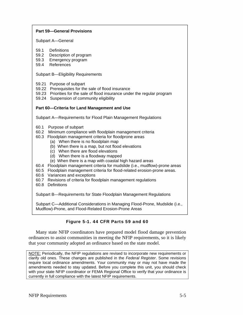
Part 59—General Provisions
Subpart A—General
59.1 Definitions 59.2 Description of program 59.3 Emergency program 59.4 References
Subpart B—Eligibility Requirements
59.21 Purpose of subpart 59.22 Prerequisites for the sale of flood insurance 59.23 Priorities for the sale of flood insurance under the regular program 59.24 Suspension of community eligibility
Part 60—Criteria for Land Management and Use
Subpart A—Requirements for Flood Plain Management Regulations
60.1 Purpose of subpart 60.2 Minimum compliance with floodplain management criteria 60.3 Floodplain management criteria for floodprone areas
(a) When there is no floodplain map (b) When there is a map, but not flood elevations (c) When there are flood elevations (d) When there is a floodway mapped (e) When there is a map with coastal high hazard areas
60.4 Floodplain management criteria for mudslide (i.e., mudflow)-prone areas 60.5 Floodplain management criteria for flood-related erosion-prone areas. 60.6 Variances and exceptions 60.7 Revisions of criteria for floodplain management regulations 60.8 Definitions
Subpart B—Requirements for State Floodplain Management Regulations
Subpart C—Additional Considerations in Managing Flood-Prone, Mudslide (i.e., Mudflow)-Prone, and Flood-Related Erosion-Prone Areas
Figure 5-1. 44 CFR Parts 59 and 60
Many state NFIP coordinators have prepared model flood damage prevention ordinances to assist communities in meeting the NFIP requirements, so it is likely that your community adopted an ordinance based on the state model.
NOTE: Periodically, the NFIP regulations are revised to incorporate new requirements or clarify old ones. These changes are published in the Federal Register. Some revisions require local ordinance amendments. Your community may or may not have made the amendments needed to stay updated. Before you complete this unit, you should check with your state NFIP coordinator or FEMA Regional Office to verify that your ordinance is currently in full compliance with the latest NFIP requirements.
NFIP Requirements 5-5
COMMUNITY TYPES
NFIP regulations identify minimum requirements that communities must ful-fill to join and stay in the program. The requirements that apply to a particular community depend on its flood hazard and the level of detail of the data FEMA provides to the community. The specific requirements are in Section 60.3, and apply to communities as follows:
♦ 60.3(a) FEMA has not provided any maps or data.
♦ 60.3(b) FEMA has provided a map with approximate A Zones
♦ 60.3(c) FEMA has provided a FIRM with base flood elevations
♦ 60.3(d) FEMA has provided a FIRM with base flood elevations and a map that shows a floodway
♦ 60.3(e) FEMA has provided a FIRM that shows coastal high hazard areas (V Zones)
Two important notes:
The NFIP requirements are minimums. As noted in 44 CFR 60.1(d), “Any floodplain management regulations adopted by a State or a community which are more restrictive than the criteria set forth in this part are encouraged and shall take precedence.”
These requirements are cumulative. A 60.3(c) community must comply with all appropriate requirements of sections 60.3(a) and (b). For example, 60.3(a) in-cludes basic requirements for subdivisions and utilities that are not repeated in the later sections. All communities in the NFIP must comply with these subdivision and utility requirements.
For example, a 60.3(c) community must use the base flood elevations pro-vided on the FIRM. If that community has an approximate A Zone without a BFE, it must comply with the requirements of 60.3(b) for that area.
The rest of this unit explores the requirements of 44 CFR 60.3. It is organized by subject matter, so it will not correspond with the sections in 44 CFR. Where appropriate, the specific section numbers are referenced.
You should be able to identify where the requirements discussed in this unit appear in your ordinance. If you cannot find a specific reference or if you are not comfortable with your ordinance’s regulatory language, contact your state NFIP coordinator or FEMA Regional Office. FEMA and your state will expect you to enforce these minimum requirements as agreed to. If you don’t think your ordi-nance language is clear or up to date, you should consider an amendment to re-move any doubt.
NFIP Requirements 5-6
This unit covers the minimum requirements for participation in the NFIP. As noted, communities are encouraged to enact regulatory standards that exceed these minimums and that are more appropriate for local conditions.
The Community Rating System (CRS) is a part of the NFIP that rewards communities that implement programs that exceed the minimums. It is explained in more detail in Unit 9, Section C. Where provisions that can receive CRS credit are mentioned in this course, they are highlighted with the CRS logo.
NFIP Requirements 5-7

B. MAPS AND DATA
Flood maps and flood data were discussed in Units 3 and 4. This section builds on that information, covering the NFIP requirements as to when and how a community must use those maps and data.
Basic rule #1: Check to make sure you have the latest flood maps and data published by FEMA. You must use the latest maps to ad-minister your floodplain management ordinance.
NFIP MAPS AND DATA
A community must adopt and enforce floodplain management regulations based on data provided by FEMA (44 CFR 60.2(h)). This includes the floodplain boundaries, base flood elevations, FIRM zones and floodway boundaries shown on your current Flood Insurance Rate Map, Flood Boundary Floodway Map and/or Flood Insurance Study.
44 CFR 60.2(h): The community shall adopt and enforce flood plain manage-ment regulations based on data provided by the [Federal Insurance] Administra-tor. Without prior approval of the Administrator, the community shall not adopt and enforce flood plain management regulations based upon modified data re-flecting natural or man-made physical changes.
This requirement does not prevent a community from adopting and enforcing regulations based on data more restrictive than that provided by FEMA. For ex-ample, a community may want to regulate to an historical flood which was higher than the BFEs shown on the FIRM. However, such data must be approved by the FEMA Regional Office before it is used.
This requirement also does not prevent a community from using other techni-cal data to identify and regulate floodprone areas not shown on FEMA maps. For example, many cities and urban counties map and regulate areas on small tribu-tary streams that are not shown on the FIRM.
The community always has a say in what the latest maps and data should be. FEMA will send you proposed revisions to the official FIRM and you will have time to review them and submit your comments to FEMA before they are pub-lished. You also have a formal 90-day appeals period during which to submit your appeals before BFEs are made final. If you disagree with the FEMA data at any time and have scientific or technical data to support your position, you should submit a request for a map revision as noted in Unit 4, Section D, Maintaining and Revising NFIP Maps.
Annexations: If a property is in a recently annexed area that does not show up on your community’s map, use the county’s map and base flood elevations
NFIP Requirements 5-8
(BFEs) to determine the flood protection requirements. In fact, you should for-mally adopt the county’s FIRM in your ordinance to strengthen your basis for regulating areas not currently shown on your FIRM.
Exceptions: The basic rule does not cover every situation. Four occasions where a community may vary from the effective FIRM and other data provided by FEMA are:
♦ When the FEMA data disagree with ground elevations.
♦ When the FEMA data are insufficient. This occurs in approximate A Zones where base flood elevations and floodway boundaries are not pro-vided with the FIRM.
♦ When FEMA has provided draft revised data.
♦ When FEMA provides “advisory” flood hazard data.
These situations are discussed below.
Note: these situations only apply to the use of flood data for floodplain manage-ment purposes. Insurance agents and lenders must use the current FIRM when determining insurance rates and whether flood insurance is required. If a person wants to vary from the current FIRM to obtain different premium rates or to not have to purchase a flood insurance policy, the FIRM must be officially revised or amended.
WHEN FIRM AND GROUND DATA DISAGREE
The BFEs published in the Flood Insurance Study set the level for flood pro-tection purposes. The maps are a graphic portrayal of that information.
Since FEMA usually does not have detailed topographic mapping to use in preparing the flood maps, the flood boundaries are interpolated between cross sec-tions using whatever topographical information is available. This can result in in-accuracies in drawing the boundaries on the map.
The BFE in relation to the actual ground elevation sets the floodplain limits for regulatory purposes. When ground surveys show that a development site is above the BFE, you can record the data and issue the permit. Then, if the devel-oper or owner wants the property removed from the Special Flood Hazard Area designation, he or she can request a Letter of Map Amendment.
It is up to them to apply for a map change, not you. The procedure is dis-cussed in Unit 4, Section D.
Conversely, if site surveys show that areas considered outside the 100-year floodplain on published maps are in fact below the BFE, you should require pro-tection of new buildings to the BFE. Even though a site may be technically out-
NFIP Requirements 5-9
side the mapped SFHA, you are not doing future occupants any favors by ignor-ing the known flood hazard.
REGULATING APPROXIMATE A ZONES
The second occasion where you may vary from the data provided by FEMA is in approximate A Zones. Approximate A Zones are those areas not studied by the detailed hydrologic/hydraulic methods. These areas are shown as “unnumbered A zones” on the FIRM and “approximate 100-year flood zones” on the Flood Boundary Floodway Map. The FIS will not contain specific base flood elevations for approximate study areas nor will there be a floodway/fringe designation on the FBFM.
44 CFR 60.3(b) When the Administrator has designated areas of special flood hazards (A zones) by the publication of a community's FHBM or FIRM, but has neither produced water surface elevation data nor identified a floodway or coastal high hazard area, the community shall:…
(3) Require that all new subdivision proposals and other proposed developments (including proposals for manufactured home parks and subdivisions) greater than 50 lots or 5 acres, whichever is the lesser, include within such proposals base flood elevation data;
(4) Obtain, review and reasonably utilize any base flood elevation and floodway data available from a Federal, State, or other source, including data developed pursuant to paragraph (b)(3) of this section, as criteria for requiring that new con-struction, substantial improvements, or other development in Zone A on the community's FHBM or FIRM meet the standards …
Regulating development in approximate or unnumbered A Zones is one of the tougher jobs you’ll face, especially in counties that have large areas of such zones. 44 CFR Section 60.3(b)(4) requires that you make every effort to use any flood data available in order to achieve a reasonable measure of flood protection. Further, many states and local ordinances require a base flood elevation before a permit can be issued for any development.
Here are some tips in obtaining data needed for unnumbered A Zones. Which-ever method you use, be sure to record on the permit records where the flood ele-vation came from. This will help you be consistent with future development in the same area.
♦ Check with your state NFIP coordinator. Some states have regulations or guidance on how to obtain regulatory data. Some have repositories of data or may help conduct a new study.
♦ Check with local flood control, sanitary or watershed districts. Like state agencies, they may have their own programs for developing new flood data.
NFIP Requirements 5-10
♦ If a body of water forms a boundary between two communities, the com-munity on the other side may have a detailed study. Such base flood data are valid for both sides of a body of water.
♦ Ask the U.S. Army Corps of Engineers, U.S. Department of Agricul-ture/Natural Resources Conservation Service, or U.S. Geological Survey if they have knowledge of any flood studies, unpublished reports, or any data that may pertain to the area in question.
♦ If the property is along a stream that is near state highway structures such as bridges or culverts, the state highway department may have done a flood study to properly size the structure.
♦ If the property is on a river with a power-generating dam, the dam owner may have had to conduct a study for federal licensing.
♦ See if your engineer or the developer will conduct a study to calculate BFEs.
Data obtained from one of these other sources should be used as long as they:
♦ Reasonably reflect flooding conditions expected during the base flood,
♦ Are not known to be technically incorrect, and
♦ Represent the best data available.
The FEMA publication Managing Floodplain Development in Approximate Zone A Areas: A Guide for Obtaining and Developing Base (100-Year) Flood Elevations provides information on a number of methodologies for developing BFEs in approximate A zones. These methodologies range from detailed methods that produce BFEs and perform floodway analyses similar to those developed for a Flood Insurance Study to simplified methods that can be used in isolated areas where more costly studies cannot be justified.
If your community has approximate A Zones that are likely to be developed, you should get a copy of this document and have your engineer review it. You can also download FEMA’s Quick-2 software for computing flood elevations from the FEMA flood hazard mapping website.
Small developments
If the project is an isolated building, such as a single-family home in an unde-veloped area or a subdivision or other development that does not meet the thresh-olds in 44 CFR Section 60.3(b)(3), you still must ensure that the building is pro-tected from flood damages by meeting the requirements of 44 CFR 60.3(a)(3). This paragraph requires you to determine if the site is reasonably safe from flood-ing and, if it is not, that you ensure the building is constructed with methods and practices that minimize flood damages and meets other construction requirements. In nearly all cases the only way to do this is to require that the building be ele-vated to above an elevation that you determine.
NFIP Requirements 5-11
There are several possible ways of establishing this elevation:
♦ Walk the site with the property owner and find a site on high ground for the building. Sometimes by this method alone you can determine a safe building site or establish a safe building elevation, particularly in the floodplain of a small stream. Sometimes detailed topographic maps are available that may help.
♦ Use historical records or the flood of record (the highest known flood level for the area). It may be that a recent flood was close to the base flood. If records of the recent flood can be used, base your regulatory flood eleva-tions on them (or add a foot or two to the historical flood levels to provide a margin of error). Before you do this, get a second opinion from your state NFIP coordinator, FEMA Regional Office or other agency that is fa-miliar with the flood data you want to use.
♦ Require protection to a set elevation such as at least five feet above grade. Only use this approach if you feel confident that the five feet of elevation will provide adequate flood protection to the building.
♦ Require the permit applicant to develop a base flood elevation or develop one yourself using one of the methods in the FEMA publication Managing Floodplain Development in Approximate Zone A Areas: A Guide for Ob-taining and Developing Base (100-Year) Flood Elevations. This will usu-ally require the services of an engineer, but will be worth the additional expense if it is the only way to make sure the building is protected from flood damage. There are several methods of determining BFEs at varying costs and levels of detail.
The first three methods are not as good as requiring protection to a BFE. However, they may be more appropriate for small isolated projects where the costs of developing BFE information will be high relative to the cost of the build-ing. The third approach will result in lower flood insurance rates than if the build-ing had no protection, but the rates are not as favorable as they would be if a BFE were calculated. Examples of the possible rates are discussed in Unit 9, Section B.
Larger developments
You are encouraged to discuss the flood hazard as early as possible in discus-sions with subdividers and developers of large areas. If a subdivision or planned unit development will be partially in the floodplain, there may be ways to avoid building in the flood hazard area, which can save the developer the cost of a flood study.
44 CFR 60.3(b)(3): [Communities must] Require that all new subdivision propos-als and other proposed development (including proposals for manufactured home parks and subdivisions) greater than 50 lots or 5 acres, whichever is the lesser, include within such proposals BFE data.
NFIP Requirements 5-12
Any subdivision or other large development that meets this threshold must be evaluated to determine if the proposed site is in an approximate A Zone and whether BFEs are required. If BFEs are required, the developer must conduct the required study (the community, state or other agency may provide assistance). While the study must provide BFEs, you may want to require a floodway delinea-tion and inclusion of other data needed to ensure that the building sites will be reasonably safe from flooding.
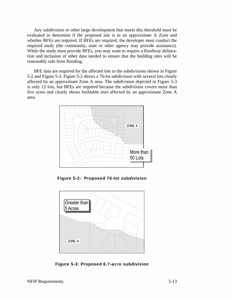
BFE data are required for the affected lots in the subdivisions shown in Figure 5-2 and Figure 5-3. Figure 5-2 shows a 76-lot subdivision with several lots clearly affected by an approximate Zone A area. The subdivision depicted in Figure 5-3 is only 12 lots, but BFEs are required because the subdivision covers more than five acres and clearly shows buildable sites affected by an approximate Zone A area.
Figure 5-2: Proposed 76-lot subdivision
Figure 5-3: Proposed 6.7-acre subdivision
NFIP Requirements 5-13
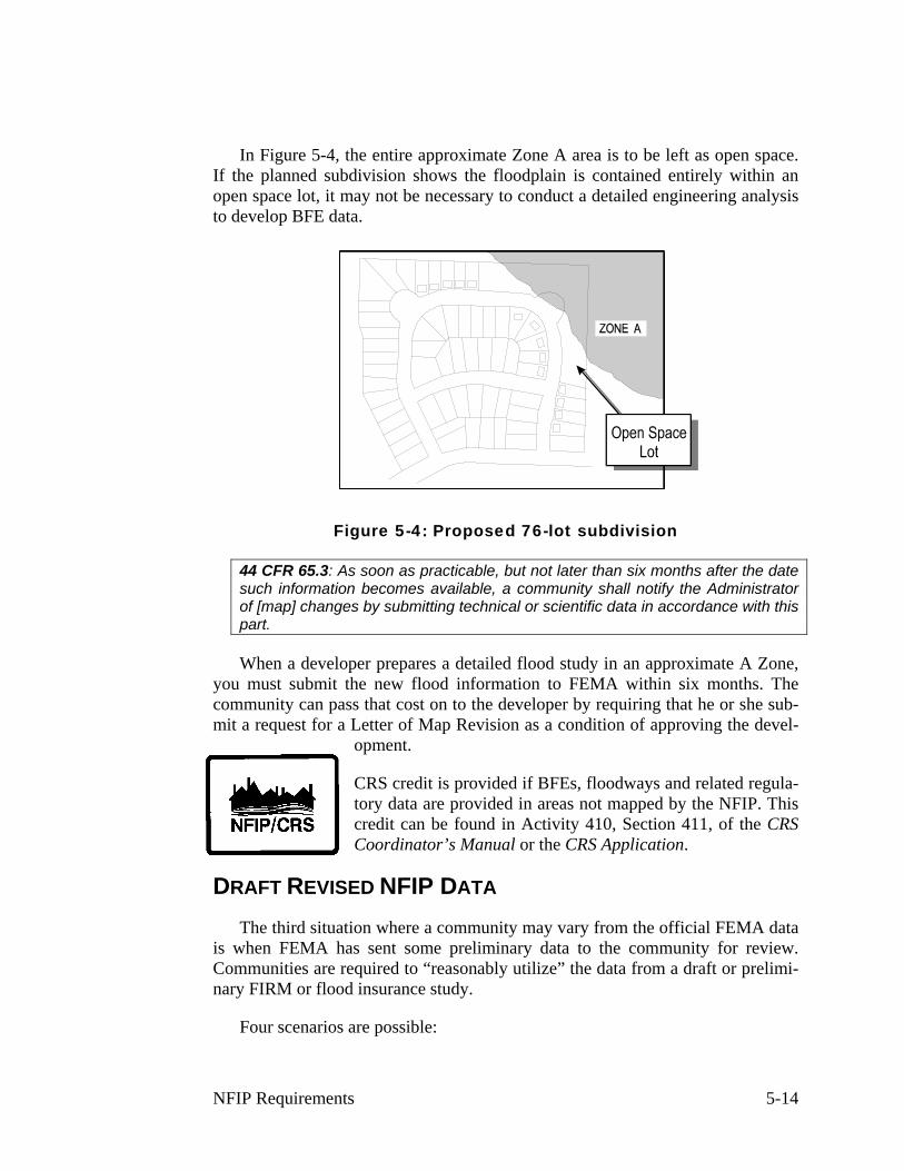
In Figure 5-4, the entire approximate Zone A area is to be left as open space. If the planned subdivision shows the floodplain is contained entirely within an open space lot, it may not be necessary to conduct a detailed engineering analysis to develop BFE data.
Figure 5-4: Proposed 76-lot subdivision
44 CFR 65.3: As soon as practicable, but not later than six months after the date such information becomes available, a community shall notify the Administrator of [map] changes by submitting technical or scientific data in accordance with this part.
When a developer prepares a detailed flood study in an approximate A Zone, you must submit the new flood information to FEMA within six months. The community can pass that cost on to the developer by requiring that he or she sub-mit a request for a Letter of Map Revision as a condition of approving the devel-
opment.
CRS credit is provided if BFEs, floodways and related regula-tory data are provided in areas not mapped by the NFIP. This credit can be found in Activity 410, Section 411, of the CRS Coordinator’s Manual or the CRS Application.
DRAFT REVISED NFIP DATA
The third situation where a community may vary from the official FEMA data is when FEMA has sent some preliminary data to the community for review. Communities are required to “reasonably utilize” the data from a draft or prelimi-nary FIRM or flood insurance study.
Four scenarios are possible:
NFIP Requirements 5-14
♦ Where the original FIRM shows an A or V Zone with no BFEs: Use the draft information. In the absence of other elevation or floodway data, the draft information is presumed to be the best available.
♦ Where the original FIRM shows an AE or VE Zone with a BFE or flood-way and the revision increases the BFE or widens the floodway: The draft revised data should be used. However, if the community disagrees with the data and intends to appeal, the existing data can be presumed to be valid and may still be used until the appeal is resolved.
♦ Where the original FIRM shows an AE or VE Zone with a base flood ele-vation or floodway and the revision decreases the BFE or shrinks the floodway: The existing data should be used. Because appeals may change the draft data, the final BFE may be higher than the draft. If you were to allow new construction at the lower level as shown in the draft, the owners may have to pay higher flood insurance premiums.
♦ Where the original FIRM shows a B, C or X Zone: NFIP regulations do not require that the draft revised data be used. However, you are encour-aged to use the draft data to regulate development, since these areas are subject to a flood hazard.
If the community intends to appeal preliminary data, it must be done during the official appeals period. Otherwise, you will have to wait for the new map to become official and submit a request for a map amendment or revision.
For more information on this issue, see Use of Flood Insurance Study (FIS) Data As Available Data, FEMA Floodplain Management Bulletin 1-98.
CLOMRs: The above four scenarios are also relevant for a Conditional Letter of Map Revision or CLOMR. Note the conditional part of a CLOMR. A CLOMR provides that if a project is constructed as designed, the BFEs can be revised or modified (or the property in question can be removed from the SFHA) AFTER the as-built specifications are submitted AND the final LOMR is issued.
A permit cannot be issued based on a lower BFE proposed by a CLOMR until the final LOMR is issued. However, you can issue a permit for that part of the work not dependent on the changes that will result from the LOMR and condition the full permit upon receipt of the final LOMR.
ADVISORY FLOOD HAZARD DATA
Sometimes FEMA issues advisory data after a major flood where it was found that the FIRM and/or flood insurance study underestimated the hazard. This in-formation is provided so communities can ensure that reconstructed buildings are protected from the true hazard, not the one shown on the FIRM.
When you receive such advisory information, you should “reasonably utilize” it. If your community agrees with the information, the ordinance should be re-
NFIP Requirements 5-15

vised to adopt it. If it disagrees with the data, you should be ready to explain why the community is not requiring construction and reconstruction to be protected. You and your community are not helping residents if you allow them to rebuild without protection from a known hazard.
For more information on this issue, see Use of Flood Insurance Study (FIS) Data As Available Data, FEMA Floodplain Management Bulletin 1-98.
NFIP Requirements 5-16
C. PERMIT REQUIREMENTS
Permits are required to ensure that proposed development projects meet the requirements of the NFIP and your ordinance. Once a person applies for a permit, you can review the plans and make sure the project complies.
Basic rule #2: A permit is required for all development in the SFHA shown on your FIRM.
The first step, therefore, is to get people to apply for a permit.
DEVELOPMENT PERMIT
44 CFR 59. Definitions: "Development" means any man-made change to im-proved or unimproved real estate, including but not limited to buildings or other structures, mining, dredging, filling, grading, paving, excavation or drilling opera-tions or storage of equipment or materials.
The NFIP requirements are keyed to “development” in the floodplain. “De-velopment” means “any man-made change to improved or unimproved real es-tate.” This includes, but is not limited to:
♦ Construction of new structures
♦ Modifications or improvements to existing structures
♦ Excavation
♦ Filling
♦ Paving
♦ Drilling
♦ Driving of piles
♦ Mining
♦ Dredging
♦ Land clearing
♦ Grading
♦ Permanent storage of materials and/or equipment
44 CFR 60.3(a)(1) [“60.3(a) communities” that do not have a FIRM must] Require permits for all proposed construction or other development in the community, in-cluding the placement of manufactured homes, so that it may determine whether such construction or other development is proposed within flood-prone areas;
If you are a 60.3(a) community, you do not have a FIRM. Consequently, you must require a permit for all development projects throughout your community.
NFIP Requirements 5-17
You must review each project’s location to determine if it has a flood risk. If it does, the best way to protect a new building from flood damage is to obtain a BFE for the site and require that the building be elevated or protected to or above that BFE.
Building permits
Most communities have long had a system for issuing building permits, but many have not had a permit system for “development.” Regulating all develop-ment in floodplains is essential because fill or other material can obstruct flood flows just as structures can.
Because a “building permit” often covers only construction or modifications of buildings, this study guide uses the term “development permit.” You should check your permit system to ensure that in the floodplain, permits are being re-quired for ALL projects that meet the definition of development, not just “building” projects. Make sure you regulate the following in addition to the traditional build-ing projects:
♦ Filling and grading.
♦ Excavation, mining and drilling.
♦ Storage of materials.
♦ Repairs to a damaged building that do not affect structural members.
♦ Temporary stream crossings
♦ Activities by other government agencies, such as roads, bridges and school buildings
If your building permit system does not require permits for these activities, you need to revise your system, enact a new type of “development permit” or oth-erwise ensure that people apply for a permit for these non-building projects.
Small projects
You have some discretion to exempt obviously insignificant activities from the permit requirement, such as planting a garden, farming, putting up a mailbox or erecting a flagpole. You may also want to exempt routine maintenance, such as painting or re-roofing.
The key is whether the project will present a new obstruction to flood flows, alter drainage or have the potential to be a substantial improvement. These deter-minations can only be made by the permit official, not the builder, so make sure your exemptions are clear. There should be no possibility of a misunderstanding resulting in construction of a flood flow obstruction or a substantial improvement without a permit.
NFIP Requirements 5-18
Some communities specifically exempt small projects in their ordinances. This is the recommended approach, as it avoids challenges that the permit official arbitrarily decides what projects need permits. Check with your state coordinating agency and/or FEMA Regional Office before you do this. You may be able to ex-empt projects (other than filling, grading or excavating) valued at less than, say, $500.
PERMITS FROM OTHER AGENCIES
44 CFR 60.3(a)(2) requires all NFIP communities to ensure that other federal and state permits have been obtained. You should not issue your local permit until you are certain that the other agencies’ requirements are met.
The purpose of this requirement is to help assure that coordination occurs be-tween various levels of government on projects impacting on floodplains. The requirement has the added benefit of protecting permit applicants by making sure they are aware of and obtain all of the permits necessary for a floodplain devel-opment prior to making irreversible financial investments. Permit applicants are not well served if they are allowed to proceed with a project only to have work stopped later by a Federal or State agency because they have not obtained proper permits.
Some communities allow their permit officials to issue the local permit on the condition that other required permits are obtained. However, this is not as effec-tive as holding the local permit until the applicant can show that the other agen-cies have issued or will issue their permits.
Otherwise, the project may get under way before you are sure that it meets all legal requirements.
To implement this requirement, you’re encouraged to develop a list of what permits are required in your jurisdiction. Your state NFIP coordinator should be able to help.
These development activities may require a state permit:
♦ Construction in the coastal zone.
♦ Construction in floodways or other designated areas.
♦ Stream crossings or projects that affect navigable rivers.
♦ Installation of septic systems.
♦ Subdivision standards or subdivision plat or lot filing requirements.
♦ Manufactured housing (mobile home) park or tie-down requirements.
♦ Public health facilities, such as hospitals and nursing homes.
♦ Alteration of sand dunes.
NFIP Requirements 5-19
♦ Operating a landfill or hazardous materials storage facility.
The more common federal regulations that may require a permit include:
♦ U.S. Army Corps of Engineers Section 404—permits for wetlands filling
♦ U.S. Army Corps of Engineers Section 10—permits for work in navigable waterways
♦ U.S. Coast Guard—permits for bridges and causeways that may affect navigation.
♦ U.S. Fish and Wildlife Service—consultations required under Sections 7 and 10 of the Endangered Species Act of 1973.
You should also check with your county; sewer, sanitary or flood control dis-trict; water management district; and any other local or regional agency that may regulate certain types of development in the floodplain.
NFIP Requirements 5-20
D. ENCROACHMENTS
Once a permit application is received and the proposed project is ready for re-view, the next job is to ensure that the project will not impose flood problems on other properties.
Basic rule #3: Development must not increase the flood hazard on other properties.
This is more of a concern in riverine situations where a project may dam or divert flowing water onto other properties or increase flood flows downstream. To prevent this, communities adopt floodways to designate those areas where flood flows are most sensitive to changes brought by development.
Communities must regulate development in these floodways to ensure that there are no increases in upstream flood elevations. For streams and other water-courses where FEMA has provided BFEs, but no floodway has been designated, the community must review developments on a case-by-case basis to ensure that these increases do not occur.
REGULATORY FLOODWAYS
44 CFR 59.1 Definitions: "Regulatory floodway" means the channel of a river or other watercourse and the adjacent land areas that must be reserved in order to discharge the base flood without cumulatively increasing the water surface eleva-tion more than a designated height.
As explained in Unit 3, Section B, the floodway is the central portion of a riv-erine floodplain needed to carry the deeper, faster moving water. Buildings, struc-tures and other development activities—such as fill—placed within the floodway are more likely to obstruct flood flows, causing the water to slow down and back up, resulting in higher flood elevations.
A floodway is included with most riverine Flood Insurance Studies and will generally be shown on the Flood Insurance Rate Map (FIRM). Some of the older Flood Insurance Studies will have a separate floodway map. The community of-ficially adopts its “regulatory floodway” in its floodplain management ordinance.
ENCROACHMENT REVIEW
All projects in the regulatory floodway must undergo an encroachment review to determine their effect on flood flows and ensure that they do not cause prob-lems. Development projects in the flood fringe by definition do not increase flood heights above the allowable level, so encroachment reviews are not needed.
NFIP Requirements 5-21
44 CFR 60.3(d)(3): [In the regulatory floodway, communities must] Prohibit en-croachments, including fill, new construction, substantial improvements, and other development within the adopted regulatory floodway unless it has been demonstrated through hydrologic and hydraulic analyses performed in accor-dance with standard engineering practice that the proposed encroachment would not result in any increase in flood levels within the community during the occur-rence of the base flood discharge.
The objective of this requirement and the floodplain management ordinance to ensure that the floodway is reserved to do its natural job: carrying floodwater. The preferred approach is to avoid all development there.
Once your community adopts its floodway, you must fulfill the requirements of 44 CFR 60.3(d). The key concern is that each project proposed in the floodway must receive an encroachment review, i.e., an analysis to determine if the project will increase flood heights. You may also want to require that this review deter-mine if the project will cause increased flooding downstream. Note that the regu-lations call for preventing ANY increase in flood heights. This doesn’t mean you can allow a foot or a tenth of a foot – it means zero increase. If you do not limit the increase to zero, small increases in flood heights from individual develop-ments will cumulatively have significant impacts on flood stages and flood dam-ages. Under NFIP minimum requirements, it is assumed that there will be no cu-mulative effects since the permissible rise for any single encroachment is zero.
Projects, such as filling, grading or construction of a new building, must be reviewed to determine whether they will obstruct flood flows and cause an in-crease in flood heights upstream or adjacent to the project site.
Projects, such as such as grading, large excavations, channel improvements, and bridge and culvert replacements, should also be reviewed to determine whether they will remove an existing obstruction, resulting in increases in flood flows downstream.
Your community may conduct the encroachment review, or you may require the developer to conduct it. Most local permit officials are not qualified to make an encroachment review, so most require that this be done by an engineer at the developer’s expense.
As the permit reviewer, it is the community’s job to ensure that an activity will not cause a problem. You have two options for doing this: For every project you could require the applicant’s engineer to certify that there will be no rise in flood heights or you can make the determination for minor projects.
Encroachment certification: To ensure that the encroachment review is done right, you may want to require the developer to provide an encroachment certifi-cation. This is often called a “no-rise” certification because it certifies that the de-velopment project will not affect flood heights. An example of a form developed by the North Carolina state coordinating agency is shown in Figure 5-5.
NFIP Requirements 5-22
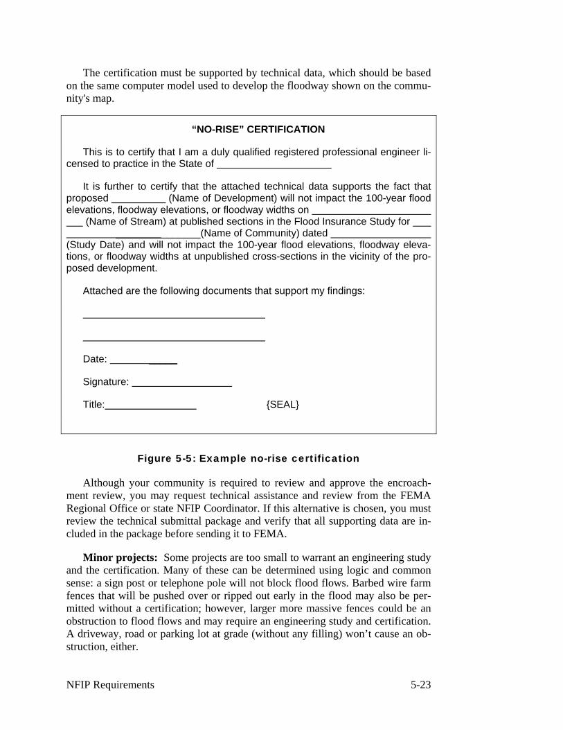
The certification must be supported by technical data, which should be based on the same computer model used to develop the floodway shown on the commu-nity's map.
“NO-RISE” CERTIFICATION
This is to certify that I am a duly qualified registered professional engineer li-censed to practice in the State of
It is further to certify that the attached technical data supports the fact that proposed (Name of Development) will not impact the 100-year flood elevations, floodway elevations, or floodway widths on
(Name of Stream) at published sections in the Flood Insurance Study for _______________(Name of Community) dated
(Study Date) and will not impact the 100-year flood elevations, floodway eleva-tions, or floodway widths at unpublished cross-sections in the vicinity of the pro-posed development.
Attached are the following documents that support my findings:
Date: _____
Signature:
Title: {SEAL}
Figure 5-5: Example no-rise certification
Although your community is required to review and approve the encroach-ment review, you may request technical assistance and review from the FEMA Regional Office or state NFIP Coordinator. If this alternative is chosen, you must review the technical submittal package and verify that all supporting data are in-cluded in the package before sending it to FEMA.
Minor projects: Some projects are too small to warrant an engineering study and the certification. Many of these can be determined using logic and common sense: a sign post or telephone pole will not block flood flows. Barbed wire farm fences that will be pushed over or ripped out early in the flood may also be per-mitted without a certification; however, larger more massive fences could be an obstruction to flood flows and may require an engineering study and certification. A driveway, road or parking lot at grade (without any filling) won’t cause an ob-struction, either.
NFIP Requirements 5-23
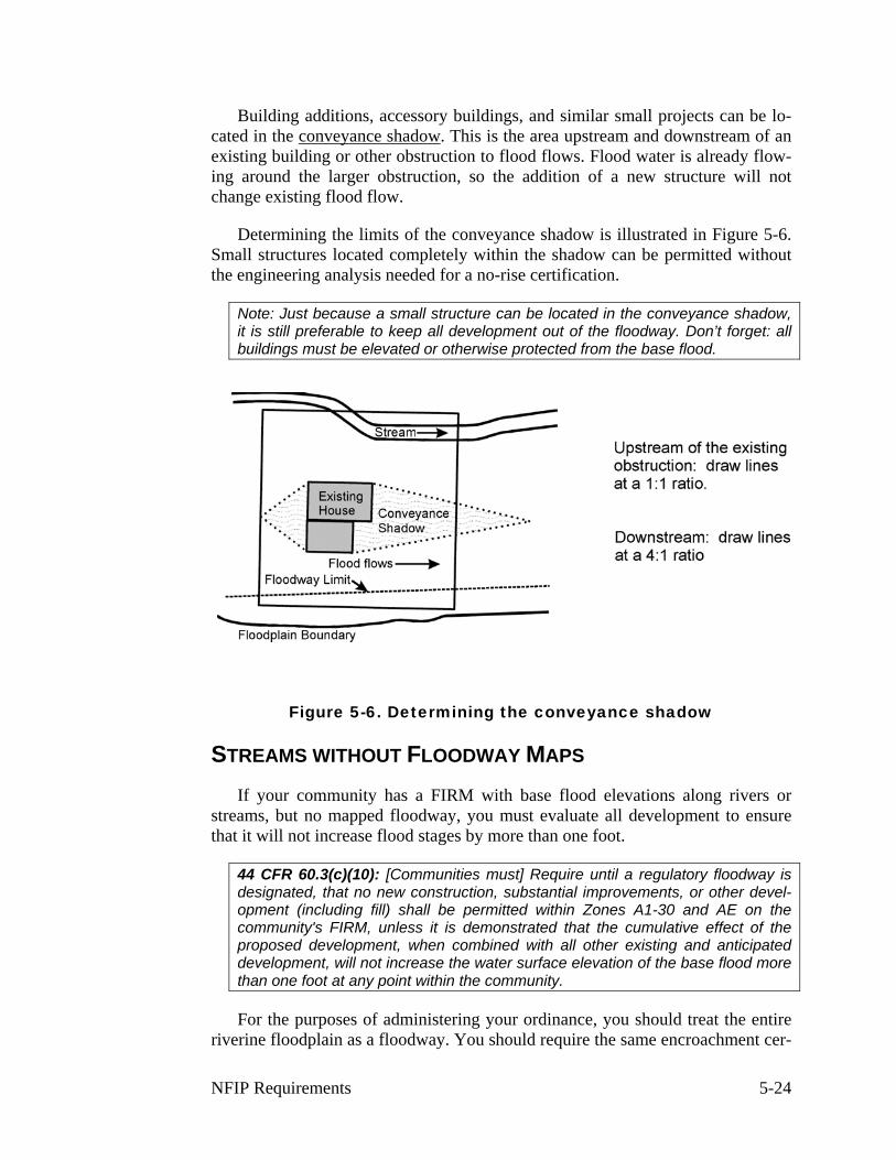
Building additions, accessory buildings, and similar small projects can be lo-cated in the conveyance shadow. This is the area upstream and downstream of an existing building or other obstruction to flood flows. Flood water is already flow-ing around the larger obstruction, so the addition of a new structure will not change existing flood flow.
Determining the limits of the conveyance shadow is illustrated in Figure 5-6. Small structures located completely within the shadow can be permitted without the engineering analysis needed for a no-rise certification.
Note: Just because a small structure can be located in the conveyance shadow, it is still preferable to keep all development out of the floodway. Don’t forget: all buildings must be elevated or otherwise protected from the base flood.
Figure 5-6. Determining the conveyance shadow
STREAMS WITHOUT FLOODWAY MAPS
If your community has a FIRM with base flood elevations along rivers or streams, but no mapped floodway, you must evaluate all development to ensure that it will not increase flood stages by more than one foot.
44 CFR 60.3(c)(10): [Communities must] Require until a regulatory floodway is designated, that no new construction, substantial improvements, or other devel-opment (including fill) shall be permitted within Zones A1-30 and AE on the community's FIRM, unless it is demonstrated that the cumulative effect of the proposed development, when combined with all other existing and anticipated development, will not increase the water surface elevation of the base flood more than one foot at any point within the community.
For the purposes of administering your ordinance, you should treat the entire riverine floodplain as a floodway. You should require the same encroachment cer-
NFIP Requirements 5-24
tification to ensure that a development project will not obstruct flood flows and cause increased flooding on other property. This approach is recommended for all other riverine floodplains without a mapped floodway.
In riverine floodplains where no floodway has been designated, the review must demonstrate that the cumulative effect of the proposed development, when combined with all other existing and anticipated development:
♦ Will not increase the water surface elevation of the base flood more than one foot at any point within the community, and
♦ Is consistent with the technical criteria contained in Chapter 5 (Hydraulic Analyses) of the Flood Insurance Study: Guidelines and Specifications for Study Contractors, FEMA-37, 1995.
This review must be required for all development projects, although you may make the same judgments on minor projects as for floodways. You should pay particular attention to developments that may create a greater than one-foot in-crease in flood stages, such as bridges, road embankments, buildings and large fills.
Note: In some states, floodways are mapped based on allowing flood heights to increase by less than one foot. In those states, the encroachment certification must be based on that more restrictive state standard, not the FEMA standard that allows a one-foot rise.
ALLOWABLE INCREASES IN FLOOD HEIGHTS
In some situations, it may be in the public interest to allow increase in flood heights greater than those allowed under the NFIP regulations.
For example, it would be hard to build a flood control reservoir without affect-ing flood heights. Because a dam would have a major impact on flood heights, there needs to be a way to permit such projects, especially those that are intended to reduce flooding.
However, when the project will change the flood level, maps must be changed to reflect the new hazard.
44 CFR 60.3(d)(4) Notwithstanding any other provisions of § 60.3, a community may permit encroachments within the adopted regulatory floodway that would re-sult in an increase in base flood elevations, provided that the community first ap-plies for a conditional FIRM and floodway revision, fulfills the requirements for such revisions as established under the provisions of § 65.12, and receives the approval of the Administrator.
If your community proposes to permit an encroachment in the floodway or the floodplain that will cause increases in the BFE in excess of the allowable level,
NFIP Requirements 5-25
you’re required to apply to the FEMA Regional Office for conditional approval of such action prior to permitting the project to occur.
As part of your application for conditional approval, you must submit:
♦ A complete application and letter of request for conditional approval of a change in the FIRM or a Conditional Letter of Map Revision (CLOMR), along with the appropriate fee for the change (contact the FEMA Regional Office for the fee amount).
♦ An evaluation of alternatives which, if carried out, would not result in an increase in the BFE more than allowed, along with documentation as to why these alternatives are not feasible.
♦ Documentation of individual legal notice to all affected property owners (anyone affected by the increased flood elevations, within and outside of the community) explaining the impact of the proposed action on their properties.
♦ Concurrence, in writing, from the chief executive officer of any other communities affected by the proposed actions.
♦ Certification that no structures are located in areas which would be af-fected by the increased BFE (unless they have been purchased for reloca-tion or demolition).
♦ A request for revision of BFE determinations in accordance with the pro-visions of 44 CFR 65.6 of the FEMA regulations.
Upon receipt of the FEMA conditional approval of the map change and prior to approving the proposed encroachments, you must provide evidence to FEMA that your community’s floodplain management ordinance incorporates the post-project condition BFEs.
NFIP Requirements 5-26
E. NEW BUILDINGS IN A ZONES BUILDINGS
Basic rule #4: New, substantially improved or substantially damaged build-ings must be protected from damage by the base flood.
In this course, the term “building” is the same as the term “structure” in the NFIP regulations. Your ordinance may use either term.
44 CFR 59.1 Definitions: "Structure" means, for flood plain management pur-poses, a walled and roofed building, including a gas or liquid storage tank, that is principally above ground, as well as a manufactured home.
The term “building” or “structure” does not include open pavilions, bleachers, carports and similar structures that do not have at least two rigid walls and a roof.
How to determine if a building is substantially improved or substantially dam-aged is discussed in Unit 8. In this unit, consider the term “building” as an all-encompassing term that includes substantial improvements and repairs of substan-tial damage to a building.
Residential and nonresidential buildings are treated differently. A residential building must have a higher level of protection—if it is to be built in the flood-plain, it must be elevated above the BFE. Nonresidential buildings, on the other hand, may be elevated or floodproofed (made watertight below the BFE).
ELEVATION
44 CFR 60.3(c)(2) [Communities must] Require that all new construction and substantial improvements of residential structures within Zones A1-30, AE and AH zones on the community's FIRM have the lowest floor (including basement) elevated to or above the base flood level…
In Zones A1-A30, AE and AH, all new construction and substantial improve-ments of residential structures must be elevated so that the lowest floor (including the basement) is elevated to or above the BFE. This can be done in one of three ways:
♦ Elevation on fill.
♦ Elevation on piles, posts, piers or columns.
♦ Elevation on walls or a crawlspace.
Fill
Fill can be used by itself or in conjunction with other types of foundations to raise the lowest floor of a building above the BFE. However, restrictions to the
NFIP Requirements 5-27
use of fill apply in floodways where fill would cause an increase in flood heights and in V zones where it would act as an obstruction to waves.
Some communities require or encourage the use of fill to elevate residential buildings because they consider fill a safer construction method since the building itself is not in contact with floodwaters. Other communities limit the use of fill in the flood fringe to protect flood storage capacity or require compensatory storage, which is discussed in Unit 6, Section C.
Where fill is the method of choice, it should be properly designed, installed in layers and compacted. Simply adding dirt to the building site may result in differ-ential settling over time.
The fill should also be properly sloped and protected from erosion and scour during flooding. To provide a factor of safety for the building and its residents, it is recom-mended that the fill extend 10 – 15 feet beyond the walls of the building before it drops below the BFE.
Piles, posts, piers or columns
Piles, piers, posts or columns are appropriate foundations for elevating buildings above the BFE where there is deeper flooding, fill is not feasible or not allowed, or for areas with high velocity flooding. Where flooding is likely to have high velocities or waves, leaving the area below the building free of obstruction with no lower area enclosure is preferred. As illustrated in Figure 5-8, this permits unrestricted flow of floodwater under the building. There will be less force applied to the building by floodwaters and less impact on flood heights than if solid walls were used.
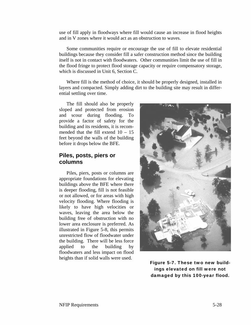
Figure 5-7. These two new build-ings elevated on fill were not
damaged by this 100-year flood.
NFIP Requirements 5-28

Figure 5-8. Elevation on piers
Walls or crawlspace
The third elevation technique is to build on solid walls. In shallower flooding areas, this elevation technique is the same as creating a crawlspace—a foundation of solid walls that puts the lowest floor above the flood level. In deeper flooding areas this often results in elevating the building a full story and creation of an en-closed area below the BFE.
When solid walls are used, care must be taken to ensure that hydrostatic or hydrodynamic pressure does not damage the walls. As discussed in Unit 1, Sec-tion B, these water pressures can cause a solid wall to collapse damaging the ele-vated portion of the building.
There are two ways to prevent this:
♦ Stem walls can be used on two sides parallel to the flow of water. The other two sides are kept open (Figure 5-9). This minimizes the obstruction to floodwaters and lessens pressure on the foundation.
♦ The walls can be built with openings large enough to allow floodwaters to flow in and out, preventing differential pressures on the walls. Openings are required any time there is a fully enclosed area below the BFE. This is discussed in more detail in the later section on enclosures.
NFIP Requirements 5-29
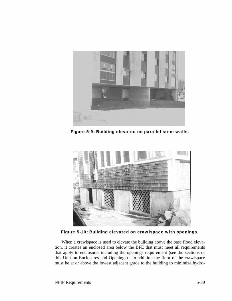
Figure 5-9: Building elevated on parallel stem walls.
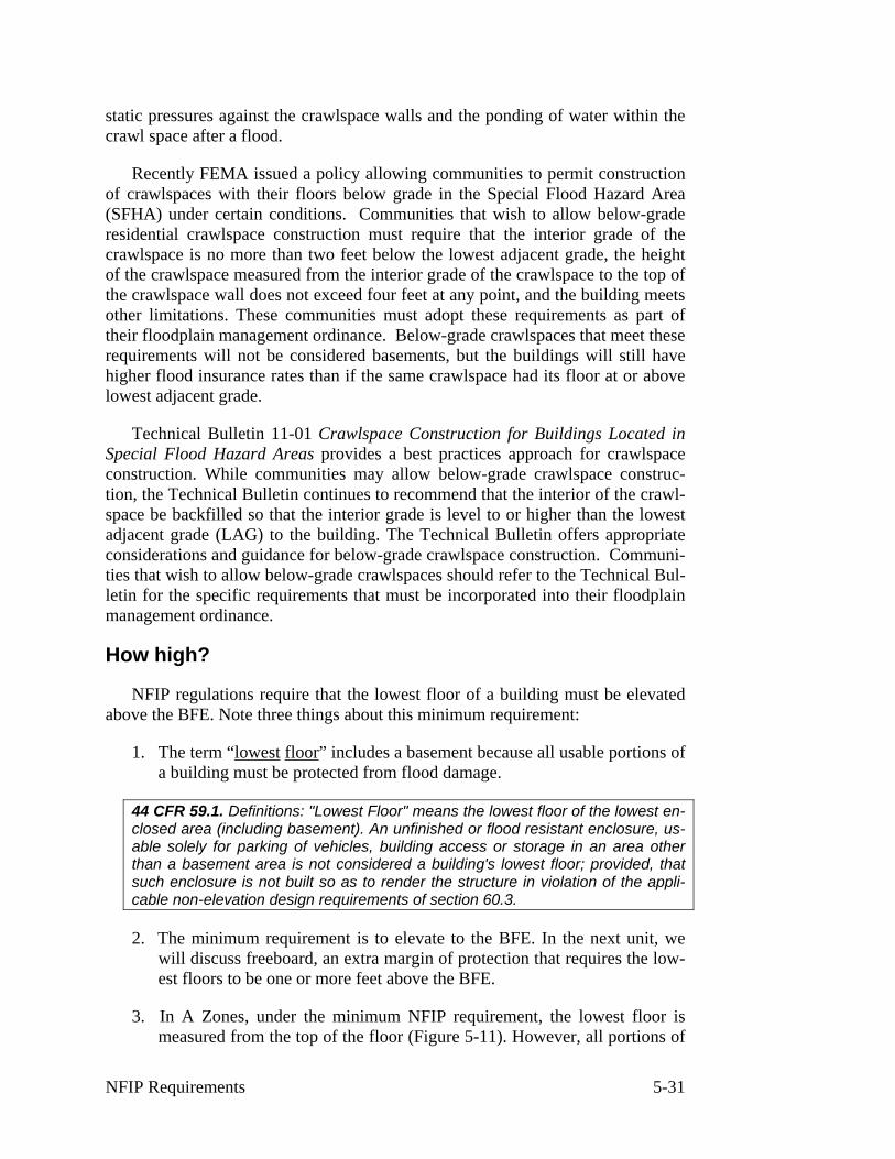
Figure 5-10: Building elevated on crawlspace with openings.
When a crawlspace is used to elevate the building above the base flood eleva-tion, it creates an enclosed area below the BFE that must meet all requirements that apply to enclosures including the openings requirement (see the sections of this Unit on Enclosures and Openings). In addition the floor of the crawlspace must be at or above the lowest adjacent grade to the building to minimize hydro-
NFIP Requirements 5-30
static pressures against the crawlspace walls and the ponding of water within the crawl space after a flood.
Recently FEMA issued a policy allowing communities to permit construction of crawlspaces with their floors below grade in the Special Flood Hazard Area (SFHA) under certain conditions. Communities that wish to allow below-grade residential crawlspace construction must require that the interior grade of the crawlspace is no more than two feet below the lowest adjacent grade, the height of the crawlspace measured from the interior grade of the crawlspace to the top of the crawlspace wall does not exceed four feet at any point, and the building meets other limitations. These communities must adopt these requirements as part of their floodplain management ordinance. Below-grade crawlspaces that meet these requirements will not be considered basements, but the buildings will still have higher flood insurance rates than if the same crawlspace had its floor at or above lowest adjacent grade.
Technical Bulletin 11-01 Crawlspace Construction for Buildings Located in Special Flood Hazard Areas provides a best practices approach for crawlspace construction. While communities may allow below-grade crawlspace construc-tion, the Technical Bulletin continues to recommend that the interior of the crawl-space be backfilled so that the interior grade is level to or higher than the lowest adjacent grade (LAG) to the building. The Technical Bulletin offers appropriate considerations and guidance for below-grade crawlspace construction. Communi-ties that wish to allow below-grade crawlspaces should refer to the Technical Bul-letin for the specific requirements that must be incorporated into their floodplain management ordinance.
How high?
NFIP regulations require that the lowest floor of a building must be elevated above the BFE. Note three things about this minimum requirement:
1. The term “lowest floor” includes a basement because all usable portions of a building must be protected from flood damage.
44 CFR 59.1. Definitions: "Lowest Floor" means the lowest floor of the lowest en-closed area (including basement). An unfinished or flood resistant enclosure, us-able solely for parking of vehicles, building access or storage in an area other than a basement area is not considered a building's lowest floor; provided, that such enclosure is not built so as to render the structure in violation of the appli-cable non-elevation design requirements of section 60.3.
2. The minimum requirement is to elevate to the BFE. In the next unit, we will discuss freeboard, an extra margin of protection that requires the low-est floors to be one or more feet above the BFE.
3. In A Zones, under the minimum NFIP requirement, the lowest floor is measured from the top of the floor (Figure 5-11). However, all portions of
NFIP Requirements 5-31
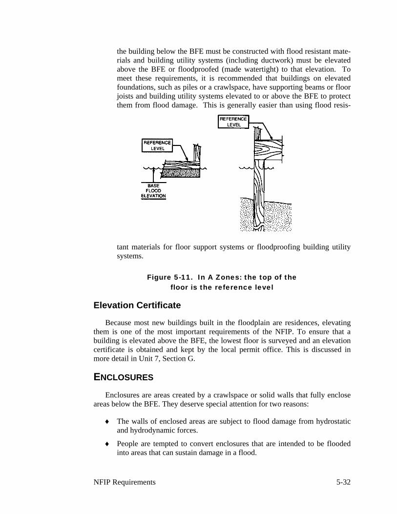
the building below the BFE must be constructed with flood resistant mate-rials and building utility systems (including ductwork) must be elevated above the BFE or floodproofed (made watertight) to that elevation. To meet these requirements, it is recommended that buildings on elevated foundations, such as piles or a crawlspace, have supporting beams or floor joists and building utility systems elevated to or above the BFE to protect them from flood damage. This is generally easier than using flood resis-
tant materials for floor support systems or floodproofing building utility systems.
Figure 5-11. In A Zones: the top of the floor is the reference level
Elevation Certificate
Because most new buildings built in the floodplain are residences, elevating them is one of the most important requirements of the NFIP. To ensure that a building is elevated above the BFE, the lowest floor is surveyed and an elevation certificate is obtained and kept by the local permit office. This is discussed in more detail in Unit 7, Section G.
ENCLOSURES
Enclosures are areas created by a crawlspace or solid walls that fully enclose areas below the BFE. They deserve special attention for two reasons:
♦ The walls of enclosed areas are subject to flood damage from hydrostatic and hydrodynamic forces.
♦ People are tempted to convert enclosures that are intended to be flooded into areas that can sustain damage in a flood.
NFIP Requirements 5-32

NFIP regulations allow certain uses in enclosures below the BFE because they can be designed so that they are subject to minimal flood damage. Three uses are allowed:
♦ building access
♦ vehicle parking
♦ storage.
The storage permitted in an enclosed lower area should be limited to that which is incidental and accessory to the principal use of the structure. For exam-ple, if the structure is a residence, storage should be limited to items such as lawn and garden equipment, bicycles, and snow tires which either have a low damage potential or that can be easily moved to the elevated portion of the building if there is a flood.
The floodplain regulation requirements can be easier to accept if owners and builders are encouraged to think about the enclosed lower areas as usable space. If a building has to be elevated, say, five feet above grade, the owner should be en-couraged to go up eight feet. This allows the lower area to be used for parking— and provides three extra feet of flood protection.
However, if the lower area is enclosed, there is a tendency for the owner to forget about the flood hazard and convert the enclosure to a bedroom or other fin-ished room. This must be prevented.
Since floodwaters are intended to enter the enclosure—it must be built of flood-resistant materials (see the section on flood-resistant materials do determine which are acceptable). Not allowed are finishings such as carpeting, paneling, in-sulation (both cellulose and fiberglass) and gypsum wallboard (also known as drywall and sheet rock).
Utilities that serve the upper level also must be protected from flood damage. Consequently, a furnace cannot be put in an enclosure unless it is located above the BFE. This is explained in more detail in Engineering Principles and Practices for Flood Damage-Resistant Building Support Utility Systems, FEMA 348, and November 1999. When the lower area enclosure is used to provide access to the upper level, a stairway can be designed that provides this access yet is resistant to flood damage. Installing an elevator is more difficult, but there are ways to design and install an elevator that will face minimal flood damage, as explained in Eleva-tor Installation for Buildings Located in Special Flood Hazard Areas, FIA-TB-4, FEMA 1993.
Openings
As noted in Unit 1, solid walls can collapse from hydrostatic pressure if floodwaters get too deep outside the building. To prevent this, an enclosure must
NFIP Requirements 5-33
have openings to allow floodwaters to enter and leave, thus automatically equaliz-ing hydrostatic flood forces on both sides of the walls.
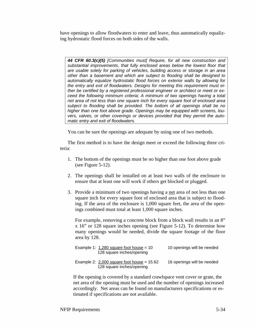
44 CFR 60.3(c)(5) [Communities must] Require, for all new construction and substantial improvements, that fully enclosed areas below the lowest floor that are usable solely for parking of vehicles, building access or storage in an area other than a basement and which are subject to flooding shall be designed to automatically equalize hydrostatic flood forces on exterior walls by allowing for the entry and exit of floodwaters. Designs for meeting this requirement must ei-ther be certified by a registered professional engineer or architect or meet or ex-ceed the following minimum criteria: A minimum of two openings having a total net area of not less than one square inch for every square foot of enclosed area subject to flooding shall be provided. The bottom of all openings shall be no higher than one foot above grade. Openings may be equipped with screens, lou-vers, valves, or other coverings or devices provided that they permit the auto-matic entry and exit of floodwaters.
You can be sure the openings are adequate by using one of two methods.
The first method is to have the design meet or exceed the following three cri-teria:
1. The bottom of the openings must be no higher than one foot above grade (see Figure 5-12).
2. The openings shall be installed on at least two walls of the enclosure to ensure that at least one will work if others get blocked or plugged.
3. Provide a minimum of two openings having a net area of not less than one square inch for every square foot of enclosed area that is subject to flood-ing. If the area of the enclosure is 1,000 square feet, the area of the open-ings combined must total at least 1,000 square inches.
For example, removing a concrete block from a block wall results in an 8” x 16” or 128 square inches opening (see Figure 5-12). To determine how many openings would be needed, divide the square footage of the floor area by 128.
Example 1: 1,280 square foot house = 10 10 openings will be needed 128 square inches/opening
Example 2: 2,000 square foot house = 15.62 16 openings will be needed 128 square inches/opening
If the opening is covered by a standard crawlspace vent cover or grate, the net area of the opening must be used and the number of openings increased accordingly. Net areas can be found on manufacturers specifications or es-timated if specifications are not available.
NFIP Requirements 5-34

The second method of meeting the requirement is to have the design certified by a registered professional engineer or architect as meeting the requirement to automatically equalize hydrostatic forces on exterior walls by allowing for the entry and exit of floodwaters. Under some circumstances it may be possible to vary the size or location of the openings based on this certification.
Openings may be equipped with screens, louvers, valves or other coverings or devices to keep animals out of the enclosure. However, any covering must permit the automatic flow of floodwater in both directions.
The opening sizes in the previous examples and in Figure 5-12 are based on the size of standard crawlspace vents, which most building codes require to be installed in a crawlspace for ventilation purposes. Often these are located close to the floor in order to circulate air around the floor joists.
Figure 5-12. Opening location in solid foundation wall
Air vents are located well above the ground in an elevated house and would not meet the NFIP requirement that the bottom of the opening be within one foot of grade. However, NFIP requirements and building codes can be satisfied by the same vents if they meet the three criteria listed above.
Garage doors cannot be used to satisfy this requirement because they do not permit the automatic flow of floodwaters. However, garage doors may have vents in them that meet the above criteria.
Openings are not required for stem wall foundations that have been backfilled with a concrete floor slab poured that is supported by the fill.
For further guidance, refer to Openings in Foundation Walls, FIA-TB-1 (FEMA 1993).
NFIP Requirements 5-35
Use
Enclosed areas are designed to be flooded and can be used only for parking vehicles, storage or access to the elevated living area—uses that can be designed so they are subject to little or no flood damage.
The type of storage permitted in an enclosed lower area should be limited to that which is incidental and accessory to the principal use of the structure. For in-stance, if the structure is a residence, the enclosure should be limited to storage of lawn and garden equipment, snow tires, and other low damage items, which can be conveniently moved to the elevated part of the building.
The interior portion of an enclosed area should not be partitioned or finished into separate rooms, except to separate the garage from the access and storage ar-eas.
If a building is elevated eight feet or more, regulating the use of the enclosure presents special problems. Over time, the owner may forget the flood hazard and want to convert the floodable area into a finished room. Such an action would in-crease the flood damage potential for the building and violate the conditions of the building permit.
However, because the room is hidden behind walls, it can be very hard for the permit office to catch such a conversion. You should carefully check new build-ing plans for signs, such as roughed in plumbing and sliding glass doors that indi-cate that the owner may expect to finish the area in the future. You should also clearly state on your permit what the limitations are on construction and use of the enclosed area.
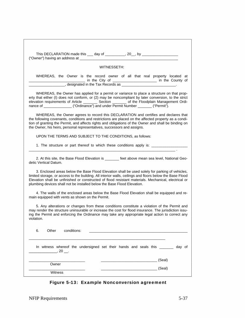
One way to help prevent conversions is to have the owner sign a nonconver-sion agreement. An example developed by the North Carolina State NFIP Coordi-nator is in Figure 5-13.
NFIP Requirements 5-36
____________________________________________________________________
This DECLARATION made this ___ day of __________, 20__, by __________________ (“Owner”) having an address at _________________________________________________
WITNESSETH:
WHEREAS, the Owner is the record owner of all that real property located at ____________________________ in the City of ______________________ in the County of __________________, designated in the Tax Records as ___________________________.
WHEREAS, the Owner has applied for a permit or variance to place a structure on that prop-erty that either (I) does not conform, or (2) may be noncompliant by later conversion, to the strict elevation requirements of Article _______ Section _______ of the Floodplain Management Ordi-nance of ______________ (“Ordinance”) and under Permit Number _______ (“Permit”).
WHEREAS, the Owner agrees to record this DECLARATION and certifies and declares that the following covenants, conditions and restrictions are placed on the affected property as a condi-tion of granting the Permit, and affects rights and obligations of the Owner and shall be binding on the Owner, his heirs, personal representatives, successors and assigns.
UPON THE TERMS AND SUBJECT TO THE CONDITIONS, as follows:
1. The structure or part thereof to which these conditions apply is: __________________ _________________________________________________________________________ .
2. At this site, the Base Flood Elevation is _______ feet above mean sea level, National Geo-detic Vertical Datum.
3. Enclosed areas below the Base Flood Elevation shall be used solely for parking of vehicles, limited storage, or access to the building. All interior walls, ceilings and floors below the Base Flood Elevation shall be unfinished or constructed of flood resistant materials. Mechanical, electrical or plumbing devices shall not be installed below the Base Flood Elevation.
4. The walls of the enclosed areas below the Base Flood Elevation shall be equipped and re-main equipped with vents as shown on the Permit.
5. Any alterations or changes from these conditions constitute a violation of the Permit and may render the structure uninsurable or increase the cost for flood insurance. The jurisdiction issu-ing the Permit and enforcing the Ordinance may take any appropriate legal action to correct any violation.
6. Other conditions: _________________________________________________
In witness whereof the undersigned set their hands and seals this _______ day of ______________, 20 __.
____________________________ ____________________________ (Seal) Owner
____________________________ ____________________________ (Seal) Witness
Figure 5-13: Example Nonconversion agreement
NFIP Requirements 5-37
FLOODPROOFING
Nonresidential buildings must be elevated or floodproofed. If they are ele-vated, they must meet the same standards as for residential buildings that were just reviewed. Elevation is the preferred method of flood protection because it is more dependable. Elevated commercial and industrial buildings can often be de-signed so that they can continue to operate during a flood reducing or eliminating business disruptions. Also, it will generally prove to be less expensive to elevate a non-residential building than to floodproof it. However, there will be situations where floodproofing may be the only feasible alternative for protecting a nonresi-dential building.
44 CFR 59.1. Definitions: "Flood proofing" means any combination of structural and non-structural additions, changes, or adjustments to structures which reduce or eliminate flood damage to real estate or improved real property, water and sanitary facilities, structures and their contents.
44 CFR 60.3(c)(3) [Communities must] Require that all new construction and substantial improvements of non-residential structures within Zones A1-30, AE and AH zones on the community's firm (i) have the lowest floor (including base-ment) elevated to or above the base flood level or, (ii) together with attendant util-ity and sanitary facilities, be designed so that below the base flood level the structure is watertight with walls substantially impermeable to the passage of wa-ter and with structural components having the capability of resisting hydrostatic and hydrodynamic loads and effects of buoyancy;
44 CFR 60.3(c)(4) [Communities must] Provide that where a non-residential structure is intended to be made watertight below the base flood level, (i) a regis-tered professional engineer or architect shall develop and/or review structural design, specifications, and plans for the construction, and shall certify that the design and methods of construction are in accordance with accepted standards of practice for meeting the applicable provisions of paragraph (c)(3)(ii) or (c)(8)(ii) of this section, and (ii) a record of such certificates which includes the specific elevation (in relation to mean sea level) to which such structures are floodproofed shall be maintained with the official designated by the community under §59.22(a)(9)(iii);
For the purposes of regulating new construction, floodproofing is defined measures incorporated in the design of the building so that below the BFE:
♦ Walls are watertight (substantially impermeable to the passage of water),
♦ Structural components can resist hydrostatic and hydrodynamic loads and effects of buoyancy, and
♦ Utilities are protected from flood damage.
Most floodproofing is appropriate only where floodwaters are less than three feet deep, since walls and floors may collapse under higher water levels.
NFIP Requirements 5-38
A registered professional engineer or architect must prepare the building plans and certify the floodproofing measures, preferably using the FEMA Floodproof-ing Certificate form. This is discussed in more detail in Unit 7, Section G.
Floodproofing techniques that require human intervention are allowed but should be discouraged. Human intervention means that a person has to take some action before the floodwater arrives, such as turn a valve, close an opening or switch on a pump. There are many potential causes of failure for these techniques, including inadequate warning time, no person on duty when the warning is issued, the responsible person can’t find the right parts or tools, the person is too excited or too weak to install things correctly, and/or the electricity fails.
Before you approve plans for a building that relies on human intervention to be floodproofed, you should make sure that there are plans and precautions to keep such problems from occurring. Techniques that rely on human intervention should only be allowed in areas with adequate warning time and in situations where there will be someone present who is capable of implementing or installing the required measures.
More information on floodproofing can be found in FEMA’s Technical Bulle-tin 3-93, Non-Residential Floodproofing Requirements and Certification for Buildings Located in Special Flood Hazard Areas (FIA-TB-3. 1993)
How high?
The minimum NFIP requirement is to floodproof a building to the BFE. How-ever, when it is rated for flood insurance, one foot is subtracted from the flood-proofed elevation. Therefore, a building has to be floodproofed to one foot above the BFE to receive the same favorable insurance rates as a building elevated to the BFE. Unit 9, Section B, discusses this in more detail.
NFIP Requirements 5-39

BASEMENTS
For the purposes of the NFIP, a basement is defined as any area that is sub-grade on all sides. The “lowest floor” of a building is the top of the floor of the basement if there is a basement. Since the “lowest floor” of a residential building must be at or above the BFE, it will be highly unusual to construct a basement in a floodplain that met these requirements.
44 CFR 59.1 Definitions: "Basement" means any area of the building having its floor subgrade (below ground level) on all sides.
Note that “walkout basements,” "daylight basements" or "terrace levels" are usually subgrade on only three sides, with the downhill side at or above grade. Thus, they are not considered basements for either floodplain management or flood insurance rating purposes (but they are still the lowest floor of a building for floodplain management and insurance rating purposes). If these areas are used only for parking, access, or storage and they meet other ordinance requirements, they can be regulated as enclosures below an elevated building and not be consid-ered the lowest floor of the building.
On the other hand, cellars, the lower level of a split-level or bi-level house, garden apartments and other finished floors below grade are considered base-ments under NFIP regulations.
Since the lowest floor of a residential building must be above the BFE, the only way to build a residential basement in the floodplain under NFIP minimum requirements is if it is elevated on fill and surrounded by fill. Floodproofed non-residential basement are allowed, provided they meet the requirements discussed in the previous section on floodproofing.
BASEMENT EXCEPTIONS
A few communities have obtained exceptions to the NFIP regulations that al-low them to permit floodproofed residential basements. The soil types and flood-ing conditions in these communities allow construction of floodproofed base-ments that are not subject to damage by hydrostatic or hydrodynamic forces.
A community may apply for an exception to allow floodproofed residential basements if it can demonstrate flood depths are less than five feet, velocities are less than five feet per second, there is adequate warning time for the site and it has appropriate construction requirements. This exception is explained in 44 CFR 60.6(c).
Buildings with floodproofed basements must have their design certified by a registered engineer or architect and are more difficult and more expensive to con-struct than buildings elevated above the BFE. Improperly designed or constructed
NFIP Requirements 5-40
basements can collapse or otherwise fail resulting in major damage to the struc-ture.
BASEMENTS AND LOMR-F AREAS
It has become a common practice in some areas of the country to fill an area to above the BFE and then obtain a Letter of Map Revision based on fill (LOMR-F) to remove the land from the floodplain. Once the land is no longer in the floodplain, the builder obtains permits to build residences with basements below the BFE. This practice has raised a number of issues and concerns:
♦ The procedure was being used to get around community floodplain man-agement ordinances.
♦ Buildings with basements below BFE were being built too close to the edges of these fills that could be subject to severe flood damage if the basement walls are subjected to hydrostatic pressure from surface water or groundwater during flooding.
♦ LOMR-Fs for nearly identical buildings were being granted or not granted based on the date the LOMR was applied for and not on the risk to the building.
FEMA issued a final rule on May 4, 2001 revising LOMR-F procedures to address these issues. The new procedure places responsibility back in the hands of the community by requiring that, before a LOMR-F is granted, the community sign a community acknowledgement form and make findings that:
♦ The project, including any buildings, meets all the requirements of the community’s floodplain management ordinance, and
♦ Any existing or future development on the filled area is “reasonably safe from flooding”.
FEMA will not act on a LOMR-F request without this acknowledgement.
44 CFR 65.2(c) “Reasonably safe from flooding” means that base flood waters will not inundate the land or damage structures to be removed from the SFHA and that any subsurface waters related to the base flood will not damage exist-ing or proposed buildings.”
FEMA has issued Technical Bulletin 10-01 Ensuring That Structures Built on Fill In or Near Special Flood Hazard Areas Are Reasonably Safe From Flooding to provide guidance on how to make the determination that an area is “reasonably safe from flooding”. The risk to buildings built in these areas will vary depend-ing on soil conditions, the location of the building relative to the edge of the fill, and whether the building will have a basement below the BFE.
NFIP Requirements 5-41
The safest method of constructing a building on filled land removed from the SFHA is to elevate the entire building above BFE. If basements are to be built in these areas, Technical Bulletin 10-01 provides a simplified method for determin-ing whether those basements will be “reasonably safe from flooding”.
Communities have asked for guidance on how they can ensure that future buildings placed on the property will be “reasonably safe from flooding” since, once the LOMR-F is issued, the land is no longer in the SFHA and generally is not subject to their floodplain management ordinance. Communities have several options they can use.
They can withhold signing the acknowledgement until the LOMR-F applicant provides sufficient information on the location and type of proposed buildings to evaluate those building sites against the criteria in Technical Bulletin 10-01. For example, the community could require submission of a subdivision plat or grading plan showing future building locations.
They could adopt or use other requirements that allow them to ensure any fu-ture buildings on the filled property remain reasonably safe from flooding. For example, a community may have building code requirements to ensure that any future basements are properly constructed to resist damage from groundwater.
Technical Bulletin 10-01 provides a number of other alternatives for ensuring that unimproved land is “reasonably safe from flooding” and stays that way. Communities have the option of requiring that the applicant submit any engineer-ing information necessary to make the determination.
The criteria in Technical Bulletin 10-01 can also be used to ensure that build-ings built with basements that are adjacent to the floodplain are constructed in a way that minimizes potential damages from groundwater during a flood.
For further information, see Technical Bulletin 10-01 Ensuring that structures Built on Fill in or Near Special Flood Hazard Areas are Reasonably Safe from Flooding in Accordance with the National Flood Insurance Program (TB 10-01).
ANCHORING
44 CFR 60.3(a)(3) …If a proposed building site is in a flood-prone area, all new construction and substantial improvements shall (i) be designed (or modified) and adequately anchored to prevent flotation, collapse, or lateral movement of the structure resulting from hydrodynamic and hydrostatic loads, including the ef-fects of buoyancy…
Both elevated and floodproofed buildings must be properly anchored to stabi-lize them against flood forces. This means anchoring the building to its founda-tion and ensuring that the foundation won’t move. Therefore, you need to make sure there is adequate protection against hydrostatic and hydrodynamic forces and erosion and scour that can undercut the foundation.
NFIP Requirements 5-42
In areas of shallow flooding and low flood velocities, normal construction practices suffice. Additional anchoring measures, such as reinforcing crawlspace walls, using deeper footings, using extra bolts to connect the sill to the foundation, or installing rods to connect the cap to the sill, should be required in three situa-tions:
♦ Where the flood flows faster than five feet per second.
♦ In coastal areas subject to waves and high winds.
♦ In manufactured or mobile homes (see the section on Manufactured Ho-mes for details).
In some areas it may be necessary to use foundations such as piles or piers which provide less resistance to floodwaters.
If your community has any of these conditions, you should see if there are state standards that take these into account, such as state coastal construction or manufactured housing (mobile home) tie-down regulations. If not, it is recom-mended that the builder’s architect or engineer sign a statement saying the design of the building includes “anchoring adequate to prevent flotation, collapse and lateral movement” during the base flood.
FLOOD-RESISTANT MATERIAL
Whether a building is elevated or floodproofed, it is important that all parts exposed to floodwaters be made of flood-resistant materials (Figure 5-14). This includes all portions of the building below the BFE including foundation elements such as floor beams and joists and any below BFE enclosures.
44 CFR 60.3(a) (3) …If a proposed building site is in a flood-prone area, all new construction and substantial improvements shall (ii) be constructed with materials resistant to flood damage…
“Flood-resistant materials” include any building product capable of withstand-ing direct and prolonged contact with floodwaters without sustaining significant damage. “Prolonged contact” means at least 72 hours, and “significant damage” is any damage requiring more than low-cost cosmetic repair (such as painting).
NFIP Requirements 5-43
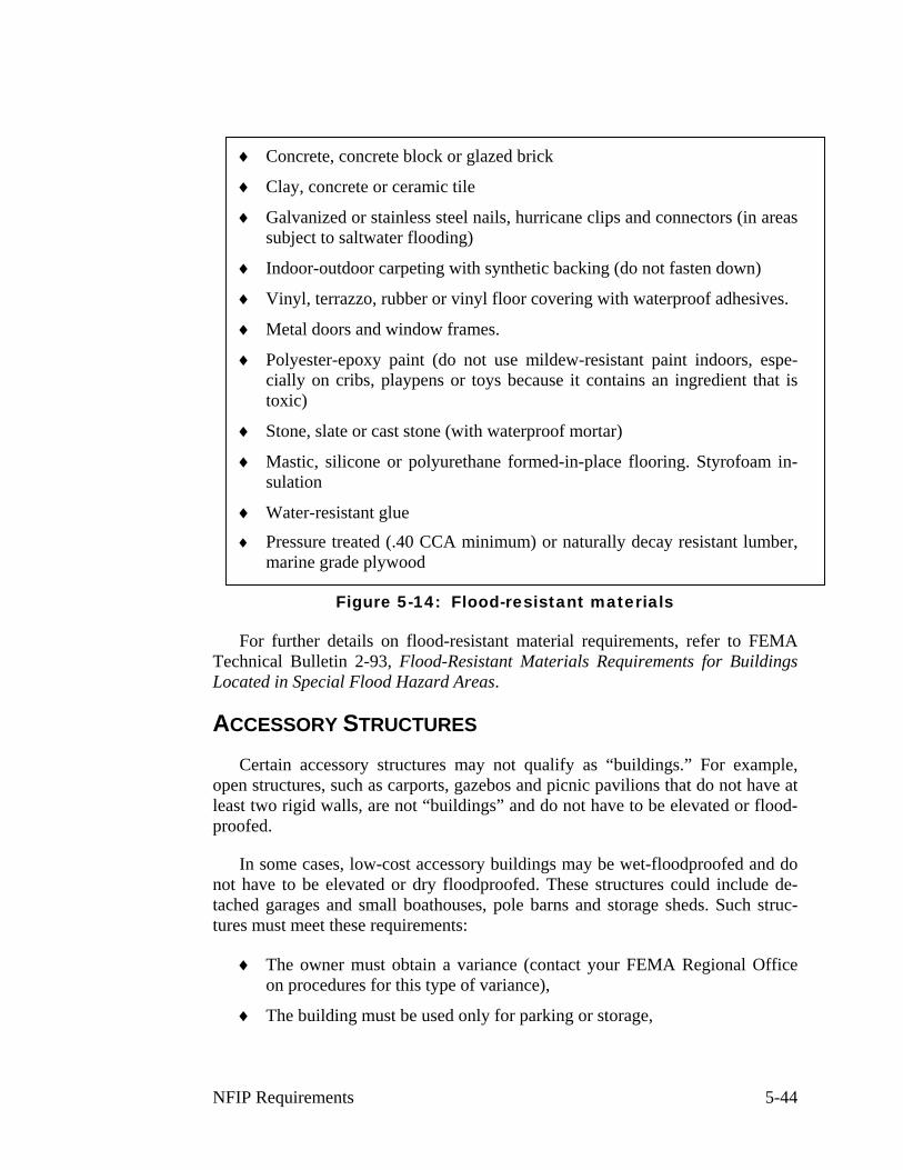
♦ Concrete, concrete block or glazed brick
♦ Clay, concrete or ceramic tile
♦ Galvanized or stainless steel nails, hurricane clips and connectors (in areas subject to saltwater flooding)
♦ Indoor-outdoor carpeting with synthetic backing (do not fasten down)
♦ Vinyl, terrazzo, rubber or vinyl floor covering with waterproof adhesives.
♦ Metal doors and window frames.
♦ Polyester-epoxy paint (do not use mildew-resistant paint indoors, espe-cially on cribs, playpens or toys because it contains an ingredient that is toxic)
♦ Stone, slate or cast stone (with waterproof mortar)
♦ Mastic, silicone or polyurethane formed-in-place flooring. Styrofoam in-sulation
♦ Water-resistant glue
♦ Pressure treated (.40 CCA minimum) or naturally decay resistant lumber, marine grade plywood
Figure 5-14: Flood-resistant materials
For further details on flood-resistant material requirements, refer to FEMA Technical Bulletin 2-93, Flood-Resistant Materials Requirements for Buildings Located in Special Flood Hazard Areas.
ACCESSORY STRUCTURES
Certain accessory structures may not qualify as “buildings.” For example, open structures, such as carports, gazebos and picnic pavilions that do not have at least two rigid walls, are not “buildings” and do not have to be elevated or flood-proofed.
In some cases, low-cost accessory buildings may be wet-floodproofed and do not have to be elevated or dry floodproofed. These structures could include de-tached garages and small boathouses, pole barns and storage sheds. Such struc-tures must meet these requirements:
♦ The owner must obtain a variance (contact your FEMA Regional Office on procedures for this type of variance),
♦ The building must be used only for parking or storage,
NFIP Requirements 5-44
♦ The building must have the required openings to allow floodwaters in and out,
♦ The building must be constructed using flood resistant materials below the BFE,
♦ The building must be adequately anchored to resist floatation, collapse, and lateral movement, and
♦ All building utility equipment including electrical and heating must be elevated or floodproofed.
Wet floodproofing involves using flood-resistant materials below the BFE and elevating things subject to flood damage above the BFE. Items that should be in-stalled above the BFE include electrical boxes, switches and outlets. Only the minimum amount of electrical equipment required by code may be located below the BFE, and that equipment must be flood damage resistant.
For additional guidance, see Wet Floodproofing Requirements, FIA-TB-7, FEMA 1994, and Engineering Principles and Practices for Flood Damage-Resistant Building Support Utility Systems.
MANUFACTURED HOMES
44 CFR 59.1 Definitions: "Manufactured home" means a structure, transportable in one or more sections, which is built on a permanent chassis and is designed for use with or without a permanent foundation when attached to the required utilities. The term "manufactured home" does not include a "recreational vehicle".
Manufactured homes include not only manufactured homes that meet HUD manufactured home standards, but also older mobile homes that pre-date these standards.
Elevation
Generally, manufactured homes must meet the same flood protection require-ment as “stick built” or conventional housing. Since they are usually residential buildings, they must be elevated so the lowest floor is above the BFE.
NFIP Requirements 5-45
44 CFR 59.1 Definitions: "Manufactured home park or subdivision" means a par-cel (or contiguous parcels) of land divided into two or more manufactured home lots for rent or sale.
44 CFR 59.1 Definitions: “Existing manufactured home park or subdivision” means a manufactured home park or subdivision for which the construction of fa-cilities for servicing the lots on which the manufactured homes are to be affixed (including, at a minimum, the installation of utilities, the construction of streets, and either final site grading or the pouring of concrete pads) is completed before the effective date of the floodplain management regulations adopted by the community.
44 CFR 60.3(c)(6) Require that manufactured homes placed or substantially im-proved within Zones A1-30, AH, and AE on the communities FIRM on sites (i) Outside of a manufactured home park or subdivision, (ii) In a new manufactured home park or subdivision, (iii) In an expansion to an existing manufactured home park or subdivision, or (iv) In an existing manufactured home or subdivision on which a manufactured home has sustained “substantial damage” as the result of a flood, be elevated on a permanent foundation such the lowest floor of the manufactured home is elevated to or above the base flood elevation and be se-curely anchored to an adequately anchored foundation system to resist floatation collapse and lateral movement.
44 CFR 60.3(c)(12) Require that manufactured homes to be placed or substan-tially improved on sites in an existing manufactured home park or subdivision within Zones A-1-30, AH, and AE on the community's FIRM that are not subject to the provisions of paragraph (c)(6) of this section be elevated so that either (I) the lowest floor of the manufactured home is at or above the base flood eleva-tion, or (ii) the manufactured home chassis is supported by reinforced piers or other foundation elements of at least equivalent strength that are no less than 36 inches in height above grade and be securely anchored to an adequately an-chored foundation system to resist floatation, collapse, and lateral movement.
44 CFR Section 60.3(c)(6) establishes the basic elevation and anchoring re-quirements that apply to most manufactured home placements including those outside of manufactured home parks and subdivision and in new manufactured home parks and subdivisions. These manufactured homes must have their lowest floors at or above the BFE. These requirements also apply to manufactured homes placed in expansions to existing manufactured home parks and on sites where manufactured homes are substantially damaged by a flood. As with stick-built housing, all parts of the manufactured home below the BFE must be con-structed with flood resistant materials and building utility systems must either be elevated or made watertight to the BFE. The best way to meet this requirement is to elevate the bottom of the manufactured home chassis to this elevation. See FEMA’s Manufactured Home Installation in Flood Hazard Areas, FEMA-85, for additional guidance
44 CFR Section 60.3(c)(12) allows for a limited exemption to elevating to the BFE for sites in existing manufactured housing (mobile home) parks. These older
NFIP Requirements 5-46
manufactured home parks were established before Flood Insurance Rate Maps (FIRMs) were issued for the community and before the community adopted a floodplain management ordinance that meets NFIP requirements. In such older parks, a newly placed manufactured home chassis must be “supported by rein-forced piers or other foundation elements of at least equivalent strength that are no less than 36 inches in height above grade.”
This exemption does not apply to repairing or replacing a manufactured home on a site in an existing manufactured home park where a manufactured home has been substantially damaged by a flood.
This exemption is a compromise that tries to balance the flood hazard against the severe economic impacts on some manufactured home park owners that would result if elevation to the BFE were required. There are often practical diffi-culties in elevating manufactured homes to the BFE in many of the older parks due to small lot sizes and the split ownership of the manufactured home and the lot itself. The exemption may not be necessary or appropriate for your commu-nity, especially if manufactured home parks are able to meet the requirement to elevate to the BFE. In other areas, the flood hazard may be so severe that the ex-emption may put lives and property at too great a risk. Many states have not in-cluded this exemption in their model ordinances and it may not be in your regula-tions.
Anchoring
44 CFR 60.3(c)(6) …[Manufactured homes must] be elevated on a permanent foundation … and be securely anchored to an adequately anchored foundation system to resist flotation, collapse and lateral movement.
A “permanent foundation” means more than a stack of concrete blocks. It should include a below-grade footing capable of resisting overturning, the depth needs to account for frost depth and expected scour, the footing must be sized ap-propriately for the site’s soil bearing capacity, and the design needs to account for seismic and other hazards.
The following types of permanent foundations can be used:
♦ Reinforced piers,
♦ Post-tensioned piers
♦ Posts,
♦ Piles,
♦ Poured concrete walls,
♦ Reinforced block walls, or
♦ Compacted fill.
NFIP Requirements 5-47
“Adequately anchored” means a system of ties, anchors and anchoring equip-ment that will withstand flood and wind forces. The system must work in satu-rated soil conditions. Usually this means over-the-top or frame tie-downs in addi-tion to standard connections to the foundation.
Most states have manufactured home tie-down regulations. Check with your state NFIP coordinator to see if your state’s regulations also meet the NFIP an-choring standard. If so, you need only make sure that the state requirement is met for each new manufactured home installed in your floodplain.
If not, see FEMA’s Manufactured Home Installation in Flood Hazard Areas, FEMA-85, for additional guidance on anchoring. The anchoring requirement does apply in an existing (pre-FIRM) manufactured housing or mobile home park. Even if the manufactured home is not elevated above the BFE, the anchoring sys-tem must still withstand the forces of a flood over the first floor.
Evacuation: In some areas, there is adequate warning time to remove a manu-factured home from harm’s way. Protecting such property should not be discour-aged, so FEMA allows an evacuated manufactured home to be put back on the original site in an existing manufactured home park without having to meet the requirements for siting a new manufactured home. Since much can go wrong in trying to evacuate a manufactured home, evacuation is not a substitute for perma-nently protecting the manufactured home by elevating it to or above the BFE.
RECREATIONAL VEHICLES
44 CFR 59.1 Definitions: "Recreational vehicle" means a vehicle which is:
(a) built on a single chassis;
(b) 400 square feet or less when measured at the largest horizontal projection;
(c) designed to be self-propelled or permanently towable by a light duty truck; and
(d) designed primarily not for use as a permanent dwelling but as temporary liv-ing quarters for recreational, camping, travel, or seasonal use.
A recreational vehicle placed on a site in an SFHA must:
♦ Meet the elevation and anchoring requirements for manufactured homes, OR
♦ Be on the site for fewer than 180 consecutive days, OR
♦ Be fully licensed and ready for highway use. “Ready for highway use” means that it is on its wheels or jacking system is attached to the site only by quick disconnect type utilities and has no permanently attached addi-tions.
NFIP Requirements 5-48
The purpose of this requirement is to prevent recreational vehicles from being permanently placed in the floodplain unless they are as well protected from flood-ing as a manufactured home.
The NFIP does not have minimum requirements for recreational vehicle parks or campgrounds other than the limitations on the placement of recreational vehi-cles. Recreational vehicle parks and campgrounds are often good uses for flood-plains, particularly when flooding usually occurs during seasons when these fa-cilities are not in use or where there is plenty of warning time prior to a flood. These facilities should not be permitted in flash flood areas since there may be loss of life if flooding occurs as well as loss of the recreational vehicles.
AO AND AH ZONES
AO Zones are shallow flooding areas where FEMA provides a base flood depth. Since there is no BFE, the rules read a little differently.
All new construction and substantial improvements of residential structures shall have the lowest floor (including basement) elevated above the highest adja-cent grade:
♦ At least as high as the depth number specified in feet on the community's FIRM, or
♦ At least two feet if no depth number is specified.
All new construction or substantial improvements of nonresidential structures shall meet the above requirements or, together with attendant utility and sanitary facilities, be floodproofed to the same elevation.
AH Zones are also shallow flooding areas, but have BFEs. Buildings in AH zones must meet the same requirements as in AE zones.
In AO and AH Zones, adequate drainage paths are required around structures on slopes to guide floodwater around and away from proposed structures. (Re-quiring this throughout the community is a good idea, as it will prevent local drainage problems from causing surface flooding.)
A99 AND AR ZONES
An A99 Zone is an SFHA that will be protected by a Federal flood control project that is currently under construction and which meets specified conditions.
An AR Zone is an SFHA that used to be a B, C or X Zone that used to be pro-tected by an accredited flood control system. The system has been decertified but is in the process of being restored to provide protection to the base flood level.
NFIP Requirements 5-49

When the flood control systems are completed or restored, the areas in A99 and AR Zones are expected to be remapped and taken out of the SFHA. Until then, they are treated as SFHA for insurance purposes and there are some flood-plain management requirements.
A99 and AR Zones are special situations—few exist. If you have one, you should contact your state NFIP coordinating agency or FEMA Regional Office for guidance on regulatory requirements for you situation.
NFIP Requirements 5-50
F. NEW BUILDINGS IN V ZONES
Zones V1-30, VE and/or V identified on FIRMs designate high hazard areas along coastlines that are subject to flooding from storm surge and wave impacts during coastal storms and hurricanes. Different construction standards apply in V-zones to help buildings withstand these wave impacts. See Unit 3 for informa-tion on how V-zones are designated. Many V Zones are also subject to erosion and scour which can undercut building foundations.
Basic rule #5: Due to wave impacts, V Zones have special building protec-tion standards in addition to the requirements for A Zones.
This section identifies only those building protection requirements that differ from the A Zone criteria. Unless mentioned in this section, all A Zone standards apply for new and substantially improved buildings in V Zones. If your commu-nity contains V-zones, you will need more information than is contained in this section to adequately regulate coastal construction. You should obtain a copy of FEMA’s Coastal Construction Manual, FEMA-55 (May 2000) and, if possible, attend a course on coastal construction offered by FEMA, your state, or a building code organization.
BUILDING LOCATION
New or substantially improved buildings in V Zones must be located land-ward of the reach of mean high tide. They cannot be built over water. In fact, it’s best to be as far back from the shore as possible in order to avoid the more dan-gerous areas subject to waves and erosion. The ability of a building to withstand wave impacts increases the farther it is set back from the shore.
Avoid areas of sand dunes and mangroves. Human alteration of sand dunes and mangrove stands within V Zones is prohibited unless it can be demonstrated that such alterations will not increase potential flood damage.
Both of these natural features are protected against alteration because they are important first lines of defense against coastal storms and can do much to reduce losses to inland coastal development.
Generally, you can assume that any removal or other alteration of a sand dune will increase flood damage. The burden should be placed on the permit applicant to demonstrate that this will not occur. This will require a report by a coastal en-gineer or geologist.
ELEVATION ON PILES OR COLUMNS
All new construction and substantial improvements to buildings in V Zones must be elevated on pilings, posts, piers or columns.
NFIP Requirements 5-51
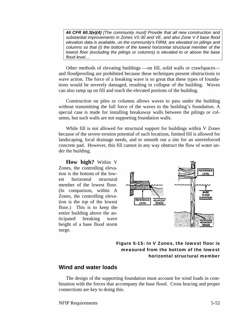
44 CFR 60.3(e)(4) [The community must] Provide that all new construction and substantial improvements in Zones V1-30 and VE, and also Zone V if base flood elevation data is available, on the community's FIRM, are elevated on pilings and columns so that (i) the bottom of the lowest horizontal structural member of the lowest floor (excluding the pilings or columns) is elevated to or above the base flood level…
Other methods of elevating buildings —on fill, solid walls or crawlspaces— and floodproofing are prohibited because these techniques present obstructions to wave action. The force of a breaking wave is so great that these types of founda-tions would be severely damaged, resulting in collapse of the building. Waves can also ramp up on fill and reach the elevated portions of the building.
Construction on piles or columns allows waves to pass under the building without transmitting the full force of the waves to the building’s foundation. A special case is made for installing breakaway walls between the pilings or col-umns, but such walls are not supporting foundation walls.
While fill is not allowed for structural support for buildings within V Zones because of the severe erosion potential of such locations, limited fill is allowed for landscaping, local drainage needs, and to smooth out a site for an unreinforced concrete pad. However, this fill cannot in any way obstruct the flow of water un-der the building.
How high? Within V Zones, the controlling eleva-tion is the bottom of the low-est horizontal structural member of the lowest floor. (In comparison, within A Zones, the controlling eleva-tion is the top of the lowest floor.) This is to keep the entire building above the an-ticipated breaking wave height of a base flood storm surge.
Figure 5-15: In V Zones, the lowest floor is measured from the bottom of the lowest
horizontal structural member
Wind and water loads
The design of the supporting foundation must account for wind loads in com-bination with the forces that accompany the base flood. Cross bracing and proper connections are key to doing this.
NFIP Requirements 5-52
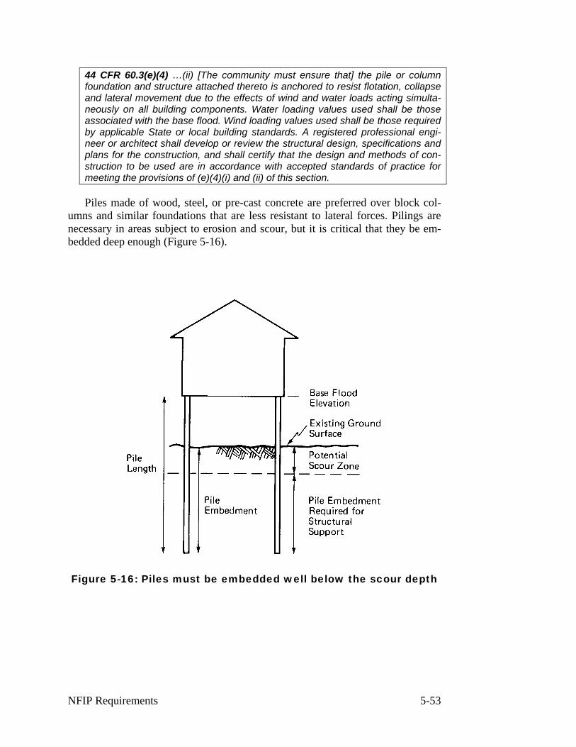
44 CFR 60.3(e)(4) …(ii) [The community must ensure that] the pile or column foundation and structure attached thereto is anchored to resist flotation, collapse and lateral movement due to the effects of wind and water loads acting simulta-neously on all building components. Water loading values used shall be those associated with the base flood. Wind loading values used shall be those required by applicable State or local building standards. A registered professional engi-neer or architect shall develop or review the structural design, specifications and plans for the construction, and shall certify that the design and methods of con-struction to be used are in accordance with accepted standards of practice for meeting the provisions of (e)(4)(i) and (ii) of this section.
Piles made of wood, steel, or pre-cast concrete are preferred over block col-umns and similar foundations that are less resistant to lateral forces. Pilings are necessary in areas subject to erosion and scour, but it is critical that they be em-bedded deep enough (Figure 5-16).
Figure 5-16: Piles must be embedded well below the scour depth
NFIP Requirements 5-53

Figure 5-17: This house had inadequate pile embedment and cross bracing
Certification
Designing and constructing a V-zone building requires the involvement of a design professional to ensure that the building will withstand the combined forces of wind and wave impact. A registered professional engineer or architect must develop or review the structural design, specifications and plans for the construc-tion, and certify that the design and planned methods of construction are in accor-dance with accepted standards of practice for meeting the above provisions.
You must maintain a copy of the engineer’s or architect’s certification in the permit file for all structures built or substantially improved in the V Zone.
The North Carolina Division of Emergency Management has prepared a V-Zone certification form (Figure 5-18) to ensure that these requirements are met. This is provided as an example. Check with your state NFIP coordinator to see if your state has developed a V Zone certification form.
BREAKAWAY WALLS
The preferred method of constructing a V-zone building is to leave the area below the elevated floor free of obstruction or to enclose the area only with lat-ticework or insect screening. That way waves can freely flow under the building without placing additional loads on the foundation. The only solid walls allowed below the lowest floor in a building in a V Zone are breakaway walls that will give way under wind and water loads without causing collapse, displacement or other damage to the elevated portion of the building or the supporting pilings or columns. Just as in A Zones, this space enclosed by these walls is to be used
NFIP Requirements 5-54
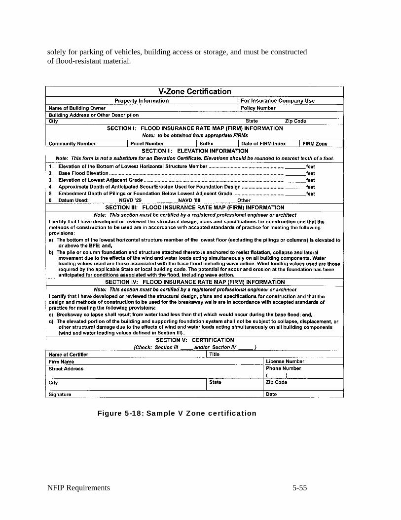
solely for parking of vehicles, building access or storage, and must be constructed of flood-resistant material.
Figure 5-18: Sample V Zone certification
NFIP Requirements 5-55
44 CFR 60.3(e)(5) [The community must] Provide that all new construction and substantial improvements within Zones V1-30, VE, and V on the community's FIRM have the space below the lowest floor either free of obstruction or con-structed with non-supporting breakaway walls, open wood lattice-work, or insect screening intended to collapse under wind and water loads without causing col-lapse, displacement, or other structural damage to the elevated portion of the building or supporting foundation system. For the purposes of this section, a breakaway wall shall have a design safe loading resistance of not less than 10 and no more than 20 pounds per square foot. Use of breakaway walls which ex-ceed a design safe loading resistance of 20 pounds per square foot (either by design or when so required by local or State codes) may be permitted only if a registered professional engineer or architect certifies that the designs proposed meet the following conditions:…
Solid breakaway walls are allowed, as are garage doors that meet the same breakaway requirements. Solid breakaway walls are intended to collapse under the force of wave impacts without damaging the buildings foundation or the ele-vated portion of the building. All solid breakaway walls should have their designs certified by a registered professional engineer or architect. This can be done as part of the anchoring certification discussed earlier in this section.
The area enclosed by solid breakaway walls should be limited to less than 300 square feet because:
♦ Flood insurance rates increase dramatically for enclosures larger than 300 square feet.
♦ Larger areas encourage conversion to habitable living areas, which are dif-ficult to detect and enforce as violations and which can sustain significant damage during a storm.
COASTAL AE ZONES
NFIP regulations apply the same minimum requirements to both coastal AE zones and riverine AE zones. FEMA has concluded that these standards may not provide adequate protection in coastal AE zones subject to wave effects, velocity flows, erosion, scour, or combinations of these forces. Wave tank studies have shown that breaking waves considerably less than the 3-foot criteria used to des-ignate VE zones can cause considerable damage.
FEMA’s Coastal Construction Manual, FEMA-55 (May 2000) and other re-cent FEMA publications have introduced the concept of Coastal AE Zone to en-courage use of V-zone construction methods and standards in these areas. For example, pile or column or other open foundations are more likely to withstand wave impacts than other types of foundations. If your community contains Coastal AE Zones, you are encouraged to revise your ordinances to apply all or some of the VE zone standards to these areas.
NFIP Requirements 5-56
G. OTHER REQUIREMENTS
The primary thrust of the NFIP regulations is to protect insurable buildings and reduce future exposure to flood hazards. However, there are some additional requirements that help ensure that the buildings stay habitable and additional flood problems are not created.
SUBDIVISIONS
As noted in Section B of this unit, once you obtain base flood elevations for a subdivision or other large development, new buildings must be properly elevated or floodproofed. These subdivisions and developments must also be reviewed to ensure they are reasonably safe from flood damage.
44 CFR 60.3(a)(4) [The community must] Review subdivision proposals and other proposed new development including manufactured home parks or subdi-visions, to determine whether such proposals will be reasonably safe from flood-ing. If a subdivision proposal or other proposed new development is in a flood-prone area, any such proposals shall be reviewed to assure that (i) all such pro-posals are consistent with the need to minimize flood damage within the flood-prone area, (ii) all public utilities and facilities, such as sewer, gas, electrical, and water systems are located and constructed to minimize or eliminate flood dam-age, and (iii) adequate drainage is provided to reduce exposure to flood hazards;
This review applies to subdivisions and other development, such as apart-ments, parks, shopping centers, schools and other projects.
If a site is floodprone, the builder should:
♦ Minimize flood damage by locating structures on the highest natural-ground.
♦ Have public utilities and facilities located and constructed so as to mini-mize flood damage.
♦ Provide adequate drainage for each building site.
The site plans of new development and proposed plats for subdivisions can usually be designed to minimize the potential for flood damage while still achiev-ing the economic goals of the project. For example, lot size could be reduced and the lots clustered on high ground, with building sites having views of the flood-plain. See Unit 6 for ideas on how subdivisions can be designed to minimize flood damages.
NFIP Requirements 5-57
WATER AND SEWER SYSTEMS
44 CFR 60.3(a)(5) [The community must] Require within flood-prone areas new and replacement water supply systems to be designed to minimize or eliminate infiltration of flood waters into the systems; and
44 CFR 60.3(a)(6) [The community must] Require within flood-prone areas (i) new and replacement sanitary sewage systems to be designed to minimize or eliminate infiltration of flood waters into the systems and discharges from the sys-tems into flood waters and (ii) onsite waste disposal systems to be located to avoid impairment to them or contamination from them during flooding.
The objective of these requirements is to ensure that a building that is pro-tected from flood damage can still be used after the flood recedes.
In most instances, these criteria can be met through careful system design. Manholes should be raised above the 100-year flood level or equipped with seals to prevent leakage. Pumping stations should have electrical panels elevated above the BFE.
On-site waste disposal systems should be located to ensure they will not re-lease contamination in a flood and can be used after flood waters recede. The first objective should be to locate the system outside the flood hazard area, if that is feasible. At a minimum, an automatic backflow valve should be installed to pre-vent sewage from backing up into the building during flooding.
WATERCOURSE ALTERATIONS
44 CFR 60.3(b)(6) [The community must] Notify, in riverine situations, adjacent communities and the State Coordinating Office prior to any alteration or reloca-tion of a watercourse, and submit copies of such notifications to the [Federal In-surance] Administrator;
The community must notify adjacent communities and the appropriate state agency prior to altering or relocating any river or stream within its jurisdiction. Copies of such notifications must be submitted to the FEMA Regional Office.
44 CFR 60.3(b)(7) [The community must] Assure that the flood carrying capacity within the altered or relocated portion of any watercourse is maintained;
Any alteration or relocation of a watercourse should not increase the commu-nity's flood risks or those of any adjacent community. This could happen if the watercourse's capacity to carry flood flow is reduced because a smaller or less-efficient channel is created, or by modifications to the floodway as a result of the project. You must ensure that the altered or relocated channel has at least the ca-pacity of the old channel. For any significant alteration or relocation, you should consider requiring the applicant to have an engineer certify that the flood-flow
NFIP Requirements 5-58
carrying capacity is maintained and that there will be no increase in flood flows downstream.
After altering a watercourse, the developer has created an artificial situation and must assume responsibility for maintaining the capacity of the modified channel in the future. Otherwise, flooding is likely to increase as the channel silts in, meanders or tries to go back to its old location.
Federal and state permits may be required for any alteration or relocation ac-tivity. It is recommended that the community require the submittal and approval of a CLOMR from FEMA for large-scale proposals (see CLOMR procedures dis-cussion in Unit 4, Section D).
NFIP Requirements 5-59