underwater archeology missions design for data gathering
TRANSCRIPT

Abstract—In this paper, we propose a methodology for
marine archeological survey, which aims at enhancing productivity and safety during on-field missions. A primary interest of the archaeological investigation is to extract, in a non invasive way, as much information as possible from a site with minimal expenditure of time and of expensive resources. In general, this is done by taking photos and measurements of objects and terrain, which are then used to construct representations of the site in form of maps. In the proposed approach, standard manual procedures for structuring the site and for gathering data of the above mentioned type have been redesigned in order to exploit beneficially the potential of cooperation between human operators and robotics devices, such as ROVs. In this way, augmented, informative maps of underwater archaeological sites can be constructed by associating, integrating and fusing data gathered by heterogeneous sensors. The analysis of data gathered employing the proposed methodology shows that satisfactory level of efficiency, efficacy and quality can be obtained and, what is more important, these advantages can be obtained without the use of extremely expensive equipments. Key words: Underwater Archaeology, Marine Technology, Data Gathering, Submarine Robotics.
I. INTRODUCTION
he exploration of submerged sites is a challenging and difficult task that represents a primary interest in
underwater archeology. In the past decades, advanced submarine technologies have been applied to investigate wreck located at high depth (see [1], [10], [11]), in situations that did not allowed the use of traditional diving techniques. In general, the use of such technologies may be very expensive and not always the archeological importance of a
Work partially supported by the European Community under project VENUS (Contract IST-034924) of the "Information Society Technologies (IST) program of the 6th FP for RTD" (www.venus-project.eu). The authors are solely responsible for the content of this paper. It does not represent the opinion of the European Community, and the European Community is not responsible for any use that might be made of data appearing therein.
site and its value give sufficiently good reasons for their use. Nevertheless, investigation of minor sites is not deprived of interest and it can produce useful information. Therefore, there is an interest in developing techniques and procedures that can combine advanced and traditional technologies in order to maximize the efficacy of both, while limiting costs.
In the present paper, we present the formalization of a procedural methodology for the cooperation, at various levels, of UUV and human operators, aimed at obtaining proper information for constructing augmented maps of underwater archaeological sites. In the proposed approach, standard manual procedures for structuring the site and for data gathering have been redesigned, following the principle of what can be called a “Design to Automation”, so to exploit fully the potential offered by the utilization of robotics devices such as ROVs and of automatic data processing.
In particular, the experience carried on by the team of the Interuniversity Centre for Integrated Systems for the Marine Environment (ISME) on various archeological sites located in Europe at a depth up to 60 m is illustrated. The work is part of the European project VENUS -Virtual ExploratioN of Underwater Sites. In its first part, the project aims at defining a set of best practices and procedures for collecting, storing and processing data in an efficient, economic and safe way from underwater archaeological sites, using state-of-the-art underwater robotics tools. Efficiency refers to the automatic collection of enough data, of sufficient good quality for allowing a satisfactory understanding of the essential characteristics of the site from the archeologist’s point of view. The economic aspect relates to the possibility of using, with suitable adaptations, off-the-shelf equipments, that archaeologists can easily obtain and employ, while safety has to do with the reduction of risks and inconvenience for divers, when operating at great depths and/or in an hostile environment.
The paper is organized as follows. In Section II, the general problem concerning the collection of data in underwater archaeological surveys is discussed. In Section
Underwater Archeology Missions Design for Data Gathering Automation
G. Conte a,S. M. Zanoli a, D. Scaradozzi a, L. Gambella a, V. Calabrò b
a Dipartimento di ingegneria Informatica, Gestionale e dell’Automazione, Università Politecnica delle Marche via Brecce Bianche, 60131 Ancona - Italy
(s.zanoli, gconte, d.scaradozzi)@univpm.it ; [email protected]
b Dipartimento Sistemi Elettrici e Automazione, Università di Pisa, via Diotisalvi 2, 56100 Pisa - Italy – [email protected]
T

III, the survey activity is described in greater details, pointing out the relevant aspects that may benefit by an increase of automation in the process. In Section IV, the activities related to the preparation of the sites for facilitating data gathering and interpretation are illustrated and recent experimental activity is reported. In Section V, the proposed procedures for automatic data collection and processing are illustrated with reference to experimental work. In Section VI, conclusions are presented.
II. PROBLEM SETTING
In traditional marine archaeological surveys, data gathering procedures involve divers for taking photos and measures, whose correlation and interpretation is facilitated by structuring the area of interest by means of frames and landmarks. Structuring the area is a hard and invasive work, that put divers and equipment at risk, as well as the manual collection of data. In order to accomplish the job in a satisfactory and exhaustive way, investigators have to return repeatedly to the same location and the whole process is cumbersome and time consuming.
The problem considered in the present work concerns the design, testing and development of a set of procedures and best practices for collecting data from underwater archaeological sites by employing robotic vehicles and automatic devices under the supervision of archaeologists and engineers, possibly in cooperation, under some circumstances, with divers. Essentially, robotic vehicles are used to carry cameras, video-cameras and acoustic sensors in order to collect optical and acoustic images of the site. These are transmitted to a supply vessel and, together with navigation data, can be automatically processed in real time or post-processed by means of suitable software tools.
In the proposed methodology, the introduction of one or more robotic vehicles in substitutions of divers is intended to speed up the exploration of the site, while allowing for possible on-line rescheduling of the mission or parameters adjusting (see [9], [12]). This is obtained by implementing a sort of logic feedback loop, based on the possibility of constructing in real time, with respect to the whole process, a map of the explored site by means of photomosaicing techniques. The fact of making the output of the survey process, namely the map, available - although in a preliminary form - in real time is one of the key advantages gained by collecting data (in this case, photos and video frames) in automatic way by means of sensors installed on robotic vehicles like ROVs. This characteristic is crucial for implementing a feedback loop and it cannot be obtained using traditional techniques based on manual data acquisition. The feedback mechanism allows the archeologists to modify some of the survey parameters (e.g. area coverage, point of sight, data density and so on) during operation, saving time and reducing costs.
Other important advantages of using robotic vehicles for collecting data are, obviously, the fact of avoiding the risks of diving and the possibility of working at high depth
Figure 1. Activities flow diagram characterizing the exploration of an underwater site with the synergistic cooperation of archeologists and engineers
for long time. At the same time, the quantity and the
density of data are greatly increased. Navigation data, in addition, allow to obtain strong correlation between photos and to construct geo-referenced maps of photogrammetric quality, augmented by information acquired by means of sonar, sub-bottom profiler and magnetometer, if available. Maps obtained in this way can be accurate enough to allow a satisfactory virtual reconstruction of the site at specified levels of precision.
III. MARINE SITE EXPLORATION ACTIVITIES
Roughly, the major activities that define the work in marine archeological surveys include: pre-analysis of the area, definition of a restricted search area, mission design, local survey, documentation, excavation, post-analysis and final documentation. Our interest in the present research is concentrated on the phases which precede the excavation. Figure 1 depicts the activities flow diagram in case ROVs and automatic data gathering are involved in the process.
The pre-analysis is meant for the specification of the search area. Generally, information about archeological remains is as vague about the objects to be identified as about their localization, so that a broad area must be covered in this initial phase. In many situations, this is done employing acoustic devices of various kinds (multibeam and sidescan sonar) for scanning the sea bottom. The output of this activity is a preliminary map of the area, whose scale is large or very large in comparison to the objects of (possible) interest, which appear as anomalies. From the analysis of the preliminary map, archeologists define a more restricted search area and possibly identify waypoints and targets that deserve special attention.
The following phase is devoted to design the survey mission, keeping into account the above information and the equipment’s features (ROV/AUV maneuverability, payload capability, support vessel/boat characteristics and so on) as well as possible environmental constraints (depth, visibility, presence of current, tides and so on). In this phase, in particular, different solutions for structuring the area of interest are considered.
Then, local survey takes place, according to the data
gathering modalities and to the navigation specifications defined in the previous phase. It is at this level that, by providing on-line a sufficiently detailed documentation of the site, the logic feedback loop described in the previous Section is implemented.
Finally, a documentation of the marine site is produced from the post analysis of the data gathered during the (various) surveys. The analysis may reveal some deficiency in the data and a consequential need for the re-execution of some of the previous activities.
The organization of the sequence of activities just described is schematically outlined in Figure 1, where all the activities are represented pictorially, their outcomes are described between bracket and blue/red arrows describe the flow of information. The logic feedback loop taking place during the survey is clearly pointed out. Off-line with respect to the survey, a second feedback loop closes after the post-analysis is performed and the documentation is produced.
IV. STRUCTURING THE SITE In the mission design phase, standard and consolidated
procedures derived from the acquired practice of traditional marine archaeological surveys represent an obvious starting point. However, as better described below, in conducting a series of specific experiments, it became clear that, for an efficient automation of the process, traditional techniques, e.g. for structuring the site, are not suitable. As in many other situations, e.g. in manufacturing, re-engineering the whole process turned out to be a winning option for facilitating the adoption of advanced automation techniques, improving functionality and efficiency and taking full benefit of innovation.
Experiments were first performed on an underwater site located near the Island of Pianosa, Italy, in October 2006. The average depth of 30 meters of the site allowed divers to operate normally, so that both manual survey procedures and automatic ones could take place. Standard archeological and photogrammetric techniques, currently used in marine archeology, were adopted. In particular, the site was structured by positioning on the seabed metric poles and a set of 15 artificial landmarks in form of concrete blocks (25cm x 25cm x 10cm). These marked the nodes of a grid whose meshes have sides of 2,5m. The metric poles and the grid were used to define paths along which photos have been taken and to evaluate, by comparison, the dimensions of photographed objects.
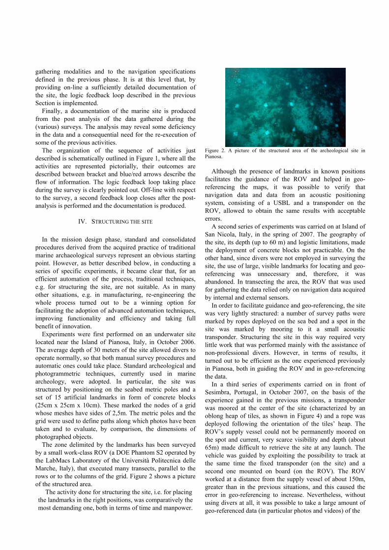
The zone delimited by the landmarks has been surveyed by a small work-class ROV (a DOE Phantom S2 operated by the LabMacs Laboratory of the Università Politecnica delle Marche, Italy), that executed many transects, parallel to the rows or to the columns of the grid. Figure 2 shows a picture of the structured area.
The activity done for structuring the site, i.e. for placing the landmarks in the right positions, was comparatively the most demanding one, both in terms of time and manpower.
Figure 2. A picture of the structured area of the archeological site in Pianosa.
Although the presence of landmarks in known positions
facilitates the guidance of the ROV and helped in geo-referencing the maps, it was possible to verify that navigation data and data from an acoustic positioning system, consisting of a USBL and a transponder on the ROV, allowed to obtain the same results with acceptable errors.
A second series of experiments was carried on at Island of San Nicola, Italy, in the spring of 2007. The geography of the site, its depth (up to 60 m) and logistic limitations, made the deployment of concrete blocks not practicable. On the other hand, since divers were not employed in surveying the site, the use of large, visible landmarks for locating and geo-referencing was unnecessary and, therefore, it was abandoned. In transecting the area, the ROV that was used for gathering the data relied only on navigation data acquired by internal and external sensors.
In order to facilitate guidance and geo-referencing, the site was very lightly structured: a number of survey paths were marked by ropes deployed on the sea bed and a spot in the site was marked by mooring to it a small acoustic transponder. Structuring the site in this way required very little work that was performed mainly with the assistance of non-professional divers. However, in terms of results, it turned out to be efficient as the one experienced previously in Pianosa, both in guiding the ROV and in geo-referencing the data.
In a third series of experiments carried on in front of Sesimbra, Portugal, in October 2007, on the basis of the experience gained in the previous missions, a transponder was moored at the center of the site (characterized by an oblong heap of tiles, as shown in Figure 4) and a rope was deployed following the orientation of the tiles’ heap. The ROV’s supply vessel could not be permanently moored on the spot and current, very scarce visibility and depth (about 65m) made difficult to retrieve the site at any launch. The vehicle was guided by exploiting the possibility to track at the same time the fixed transponder (on the site) and a second one mounted on board (on the ROV). The ROV worked at a distance from the supply vessel of about 150m, greater than in the previous situations, and this caused the error in geo-referencing to increase. Nevertheless, without using divers at all, it was possible to take a large amount of geo-referenced data (in particular photos and videos) of the

Figure 3. Relevant features, waypoints, and structuring scheme for the archeological site in San Nicola.
site, so to provide archaeologists with new evidence of its characteristics.
V. DATA FROM THE ARCHEOLOGICAL SITE For what concerns data gathered on the sites, each one of
the mentioned missions was different from the others. The reason for these differences is partially due to diversity in the available equipment, partially to the environment and partially to the improvements of the methodology.
A. Pre-analysis data The large scale maps (preliminary maps) produced in the
preliminary broad search differed greatly on each mission. In Pianosa, a geo-referenced sonar map was obtained by merging multi-beam sonar data taken from a surface vessel with DGPS information. The reduced depth of the site (about 30m) allowed to obtain a sufficiently detailed maps, where archaeological remains were identified by anomalies in the acoustic response, from the surface. Data manually collected by divers added information about kind and location of several remains (amphora and fragments).
At San Nicola, due to budgetary constraint and to the considerable depth (about 60 m), only a rough map without precise geographical references, produced by merging data collected in a series of dives, was available. Essentially, the information reduced to the indication of some points of interest on a nautical map (see Figure 3).
Finally, in Sesimbra, the situation was very similar to the one experienced in San Nicola. Due to depth, acoustic map constructed from data taken from the surface were not sufficiently detailed to be useful and technical problems caused geo-referencing to be scarcely reliable. Also in this case, the indication of some points of interest on a nautical map was available.
Figure 4. Structuring scheme for the archeological site in Sesimbra.
A. Data Acquisition In Pianosa, the ROV was equipped with a CCD video
camera, a high quality still camera (Nikon DH2 with 14 mm Sigma lens) and two flashes (Nikon SB800).
During each launch, the ROV executed a number of transects at the speed of about 1 knot, at an average distance from the sea bottom of about 3m. In this condition, each video frame covers an area of about 3m2 and video stream provides a complete coverage of a 3m wide corridor when the ROV moves along a linear path, assuring an overlap of about 60% between consecutive frames. The video camera takes 25 frames per second and, in order to have a complete documentation, the video stream was recorded by a VCR. The video stream was sampled at a frequency of 5 Hz (getting one frame over 5) by the NGC system of the ROV (implemented on a PXI/PC station) and sampled images were digitally recorded. Pictures taken by the still camera covered more or less the same area framed by the video camera (difference was less than 5%) and were recorded on the camera own flash memory. Two different procedures were adopted for the camera operation. In the first one, shooting is manually commanded by an operator, under the supervision of an archaeologist, from the ROV’s supply vessel. Operator and archaeologist can observe the scene framed by the video camera (almost coincident with that framed by the camera) on the ROV’s M/M interface. Each command to shoot was recorded as an event by the NGC system of the ROV. In the second procedures, shooting is automatic, with a fixed frequency, chosen according to the flashes’ recharging time, to the ROV’s speed and to the distance from the sea bottom.
In San Nicola, the still camera was not available, but the video camera was substituted by a new DV digital one of better quality. Only video frames were therefore available for documenting the site, but, in spite of the limitation due to their (comparatively) low resolution, this was enough for obtaining useful information about the characteristics of the site.
Both the still camera and the digital video camera were available in Sesimbra and, although reduced in quantity due to the shorter duration of the mission, collected data were of
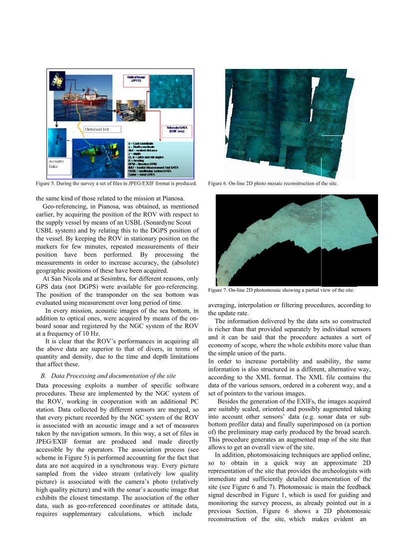
Figure 5. During
the same kindGeo-referen
earlier, by acqthe supply veUSBL systemthe vessel. Bymarkers for position havmeasurementgeographic po
At San NicGPS data (noThe positionevaluated usin
In every maddition to opboard sonar aat a frequency
It is clearthe above daquantity and that affect the
B. Data PrData processprocedures. Tthe ROV, wstation. Data that every picis associated taken by the nJPEG/EXIF accessible byscheme in Figdata are not sampled frompicture) is ashigh quality pexhibits the cdata, such asrequires sup
the survey a set
d of those relancing, in Pianquiring the possel by means
m) and by relay keeping the few minutes,ve been ps in order to ositions of thecola and at Seot DGPS) we of the transng measurememission, acouptical ones, wand registeredy of 10 Hz. r that the ROVata are superidensity, due
ese.
rocessing andsing exploits These are imporking in cocollected by
cture recordedwith an acounavigation senformat are
y the operatogure 5) is perfacquired in am the videossociated witpicture) and wclosest timestas geo-referenplementary
of files in JPEG/E
ated to the misnosa, was obtosition of the s of an USBL ating this to thROV in statio
, repeated meerformed. Bincrease accu
ese have been esimbra, for diere available sponder on tent over long
ustic images owere acquired d by the NGC
V’s performanior to that ofto the time a
d documentatioa number o
plemented by operation witdifferent sen
d by the NGCustic image annsors. In this
produced aors. The assoformed accouna synchronous stream (relh the camera
with the sonar’amp. The assced coordinacalculations,
EXIF format is pr
ssion at Pianostained, as meROV with res(Sonardyne S
he DGPS posonary positioneasurements oBy processinuracy, the (abacquired.
ifferent reasonfor geo-refer
the sea bottoperiod of time
of the sea botby means of
C system of th
nces in acquif divers, in teand depth lim
on of the siteof specific s
the NGC systh an additionsors are merC system of thnd a set of mway, a set of and made dciation procenting for the fs way. Every latively low a’s photo (res acoustic imaociation of th
ates or attitud which inc
roduced.
sa. ntioned spect to
Scout sition of n on the of their ng the bsolute)
ns, only rencing. om was e. ttom, in the on-
he ROV
iring all erms of
mitations
oftware stem of
onal PC rged, so he ROV
measures f files in directly
ess (see fact that picture quality latively age that he other de data, clude
Fig
Fig
avthe
is anectheIn infacdaset
areintboof)Thall
so repimsitsigmoprerec
gure 6. On-line 2D
gure 7. On-line 2D
veraging, intere update rate. The informatricher than th
nd it can be onomy of scoe simple union
order to information is acording to th
ata of the variot of pointers to
Besides the e suitably scato account ot
ottom profiler f) the preliminhis procedure lows to get anIn addition, p
to obtain presentation o
mmediate and te (see Figure gnal describedonitoring the evious Sectioconstruction
D photo mosaic r
D photomosaic sh
rpolation or fil
tion delivered hat provided ssaid that the
ope, where then of the parts.
ncrease portabalso structuredhe XML formous sensors, oo the various igeneration of
aled, oriented ther sensors’ data) and fina
nary map earlygenerates an
n overall view photomosaicin
in a quickof the site that
sufficiently 6 and 7). Pho
d in Figure 1,survey proce
on. Figure of the site,
reconstruction of
howing a partial v
ltering proced
by the data sseparately by e procedure ae whole exhibi bility and usd in a differen
mat. The XMLordered in a coimages.
f the EXIFs, thand possibly data (e.g. so
ally superimpy produced byaugmented mof the site.
ng techniques k way an t provides the detailed docuotomosaic is , which is useess, as already6 shows a which mak
the site.
view of the site.
dures, accordi
sets so construindividual sen
actuates a soits more value
sability, the nt, alternative L file containoherent way, a
he images acqaugmented ta
onar data or posed on (a poy the broad se
map of the site
are applied onapproximate archeologists
umentation omain the feeded for guidingy pointed out
2D photomkes evident
ng to
ucted nsors
ort of e than
same way,
ns the and a
quired aking
sub-ortion earch. e that
nline, 2D
s with f the
dback g and t in a
mosaic an
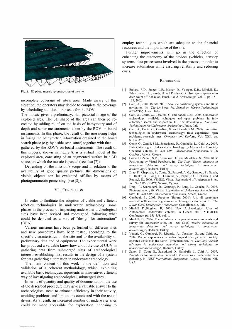
Fig. 8. 3D photo mosaic reconstruction of the site. incomplete coverage of site’s area. Made aware of this situation, the operators may decide to complete the coverage by scheduling additional transects for the ROV. The mosaic gives a preliminary, flat, pictorial image of the explored area. The 3D shape of the area can then be re-created by adding relief on the basis of bathymetry and of depth and sonar measurements taken by the ROV on-board instruments. In this phase, the result of the mosaicing helps in fusing the bathymetric information obtained in the broad search phase (e.g. by a side scan sonar) together with that gathered by the ROV’s on-board instruments. The result of this process, shown in Figure 8, is a virtual model of the explored area, consisting of an augmented surface in a 3D space, on which the mosaic is pasted (see also [7]).
Depending on the mission’s scope and in relation to the availability of good quality pictures, the dimensions of visible objects can be evaluated off-line by means of photogrammetric processing. (see [8]).
VI. CONCLUSION
In order to facilitate the adoption of viable and efficient robotics technologies in underwater archaeology, some phases in the process of inspecting underwater archeological sites have been revised and redesigned, following what could be depicted as a sort of “design for automation” (DFA).
Various missions have been performed on different sites and new procedures have been tested, according to the specific characteristics of the site and to the availability of preliminary data and of equipment. The experimental work has produced a valuable know-how about the use of UUV in gathering data from submerged sites of archaeological interest, establishing first results in the design of a system for data gathering automation in underwater archeology. The main content of this work is the definition and validation of a coherent methodology, which, exploiting available basic techniques, represents an innovative, efficient way of investigating archaeological, submerged sites.
In terms of quantity and quality of documentation, the use of the described procedure may give a valuable answer to the archaeologists’ need to enhance efficiency in their activity, avoiding problems and limitations connected with the use of divers. As a result, an increased number of underwater sites could be made accessible for exploration, choosing to
employ technologies which are adequate to the financial resources and the importance of the site.
Further improvements will go in the direction of enhancing the autonomy of the devices (vehicles, sensory systems, data processors) involved in the process, in order to increase automation while assuring reliability and reducing costs.
REFERENCES [1] Ballard, R.D., Stager, L.E., Master, D., Yoerger, D.R., Mindell, D.,
Whitcombe, L.L., Singh, H. and Piechota, D.,. Iron age shipwrecks in deep water off Ashkelon, Israel. Am. J. Archaeology, Vol. II, pp. 151-168, 2002.
[2] Caiti, A., 2002. Baratti 2001: Acoustic positioning systems and ROV navigation. In: The 1st Lerici Int. School on Marine Technologies (CD-ROM), Lerici, Italy.
[3] Caiti, A., Conte, G., Casalino, G. and Zanoli, S.M., 2004. Underwater archaeology: available techniques and open problems in fully automated search and inspection. In: The Workshop on Innovative Technologies for Underwater Archaeology, Prato, Italy
[4] Caiti, A., Conte, G., Casalino, G. and Zanoli, S.M., 2006. Innovative technologies in underwater archaeology: field experience, open problems, research lines. Chemistry and Ecology, Vol. XXII, pp. S383-S396.
[5] Conte, G., Zanoli, S.M., Scaradozzi, D., Gambella, L., Caiti, A., 2007. Data Gathering in Underwater archaeology by Means of a Remotely Operated Vehicle. In: XXI CIPA International Symposium, 01-06 October , Athens, Greece
[6] Conte, G, Zanoli, S.M., Scaradozzi, D. and Maiolatesi, S., 2004. ROV Positioning by Visual Feedback. In: The Conf. "Recent advances in underwater detection and survey techniques to underwater archaeology", Bodrum, Turkey.
[7] Drap, P., Chapman, P., Conte, G., Pascoal, A.M., Gambogi, P., Gauch, F., Hanke, K., Long, L., Loureiro, V., Papini, O., Richards, J. and Roussel, D., 2006. VENUS, Virtual ExploratioN of Underwater Sites. In: The CIPA / VAST, Nicosia, Cyprus.
[8] Drap , P., Scaradozzi, D., Gambogi, P., Long, L., Gauche, F., 2007. Photogrammetry for Virtual Exploration of Underwater Archeological Sites. In: XXI CIPA International Symposium, Athens, Greece
[9] Gambogi, P., 2003. Progetto "Baratti 2001": Uso di tecnologie avanzate nella ricerca di giacimenti archeologici sottomarini. In: The II Nat. Conf. Underwater Archaeology, Castiglioncello, Italy.
[10] Mindell D.,Bingham B, 2001. New Archaeological Uses of Autonomous Underwater Vehicles, in Oceans 2001, MTS/IEEE Conference, pp. 555-558, vol. 1.
[11] Mindell, D., 2004. Recent advances in precision measurements and survey for underwater sites. In: The Conf. "Recent advances in underwater detection and survey techniques to underwater archaeology", Bodrum, Turkey.
[12] Vettori, G., Gambogi, P., Rizzerio, A., Casalino, G., and Caiti, A., 2004. Recent experiences in archaeological surveys with remotely operated vehicles in the North Tyrrhemian Sea. In: The Conf. "Recent advances in underwater detection and survey techniques to underwater archaeology", Bodrum, Turkey.
[13] Zanoli S., Conte G., Scaradozzi D., Gambella L., Caiti A., 2007, Procedures for cooperative human-UUV missions in underwater data gathering, in UUST International Symposium, August, Durham, NH, USA.
View publication statsView publication stats