understanding the big picturesuzanneoel.com/docs/misc/pmra_stelfox_bow_basin_20140601.pdf ·...
TRANSCRIPT

11
The 2013 Bow River Basin FloodThe 2013 Bow River Basin Flood Understanding the Big PictureUnderstanding the Big Picture
A Presentation to theA Presentation to thePriddisPriddis
MillarvilleMillarville
Residents AssociationResidents Association

22
Looking West and Wondering If Looking West and Wondering If ……..

33
The FloodThe Flood

44
The ResponseThe Response

55
The CausesThe Causes

66
The Human Component The Human Component (Natural Floods versus Economic Floods)(Natural Floods versus Economic Floods)
77
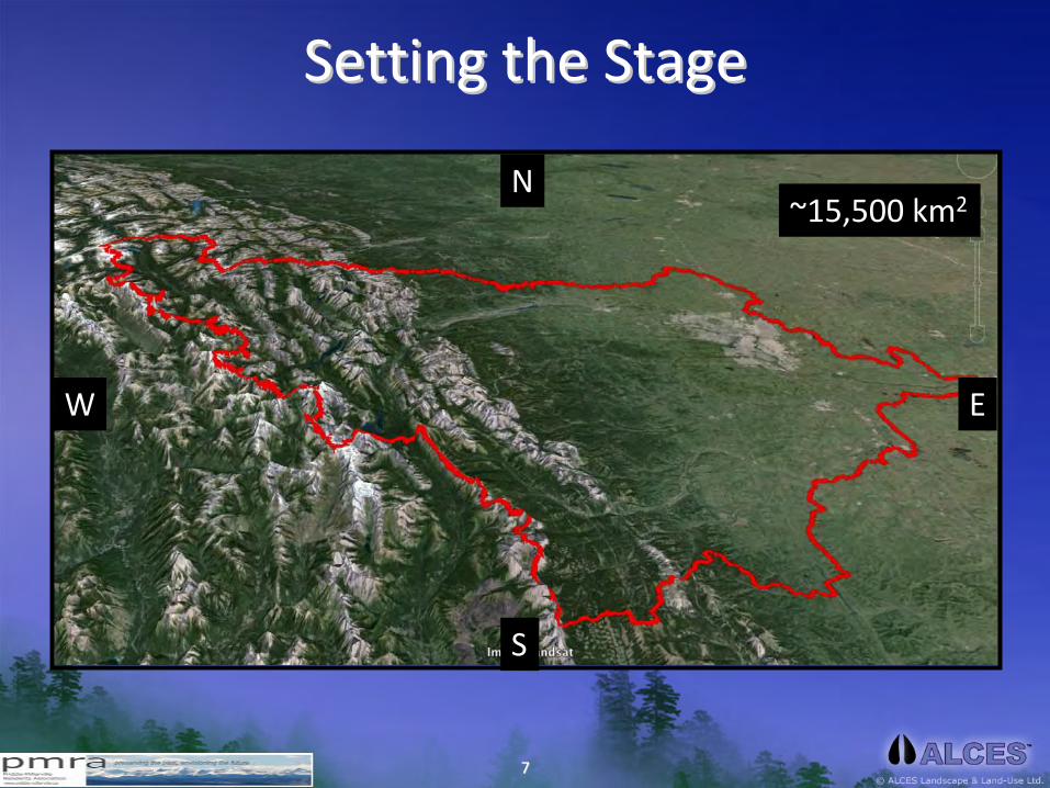
Setting the StageSetting the Stage
~15,500 km2
W E
N
S

88
This is a relatively New LandscapeThis is a relatively New Landscape
• Most recent glacial
event occurred
between 20,000 and
9,000 years
• Relatively young
landscape for soils and
vegetation
• Action of glaciers
ground up rock and
increased availability of
minerals; enhanced
plant growth and soil
formation

99
Remnants of Glacial HeadwatersRemnants of Glacial Headwaters
1010
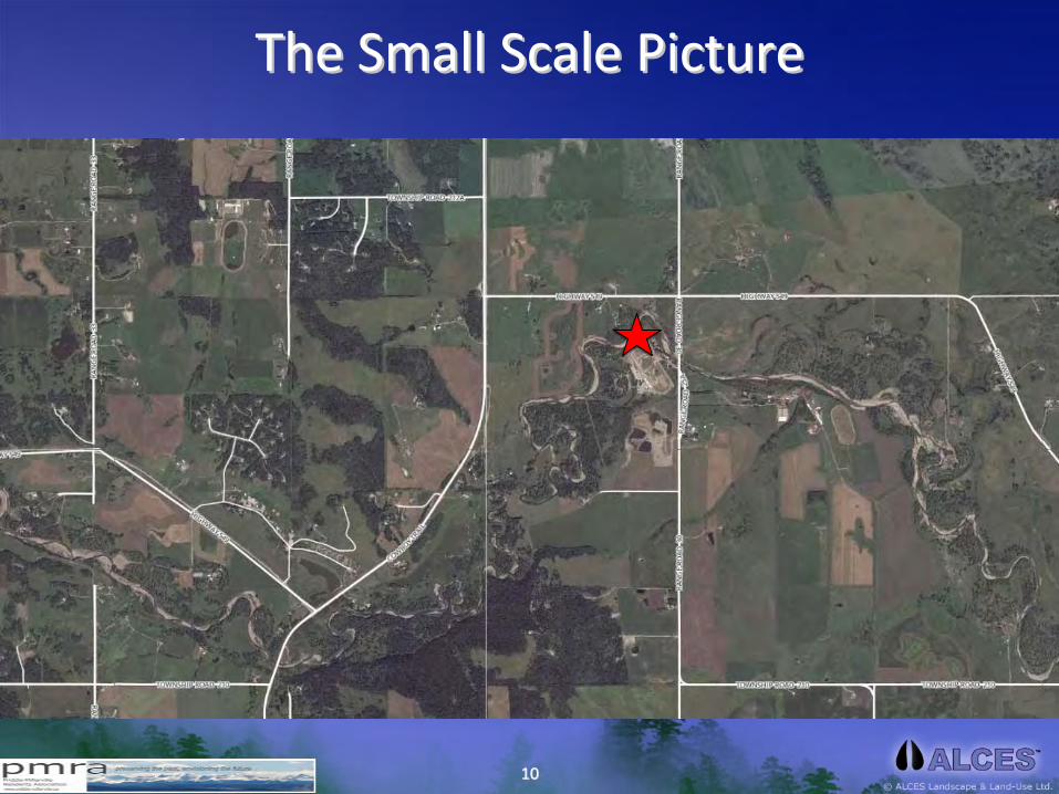
The Small Scale PictureThe Small Scale Picture

1111
The Upper Bow River BasinThe Upper Bow River Basin Source: ALCES OnlineSource: ALCES Online

1212
The Anatomy of the Bow River BasinThe Anatomy of the Bow River Basin Source: ALCES OnlineSource: ALCES Online

1313
The Basin and Selected CommunitiesThe Basin and Selected Communities
S
W
N
E
Canmore
Calgary
Cochrane
OkotoksHigh River
Turner Valley
Airdrie
Lake Louise
Bragg Creek
Black Diamond
Banff
PriddisMillarville
Chestermere
Crossfield
Longview
Redwood Meadows

1414
The Major Plumbing Pipes of the Bow River BasinThe Major Plumbing Pipes of the Bow River Basin (including alluvial aquifers)(including alluvial aquifers)
S
W
E
Bow River MainstemGhost River DrainageJumping Pound DrainageNose Hill DrainageElbow River DrainageFish Creek DrainageSheep River DrainageHighwood River DrainageExamples of Alluvial Aquifer Channels
N

1515
InterInter‐‐Annual Variation in Precipitation and FlowAnnual Variation in Precipitation and Flow AVERAGE YEARAVERAGE YEAR
S
W
N
E

1616
InterInter‐‐Annual Variation in Precipitation and FlowAnnual Variation in Precipitation and Flow DRY YEARDRY YEAR
S
W
N
E

1717
InterInter‐‐Annual Variation in Precipitation and FlowAnnual Variation in Precipitation and Flow WET YEARWET YEAR
S
W
Redwood Meadows
N
E
1818
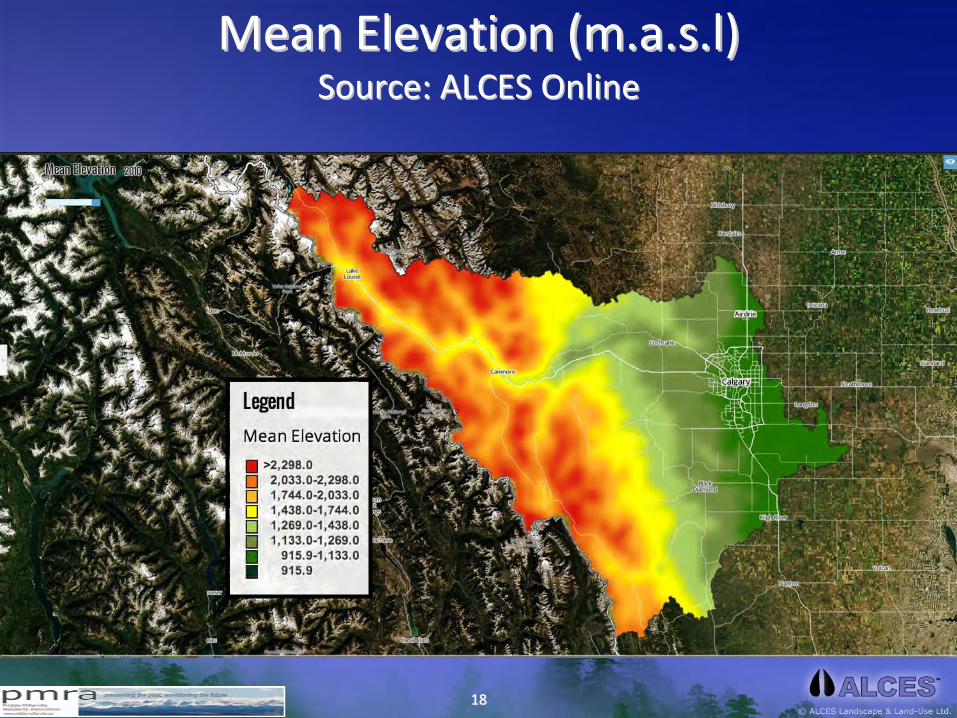
Mean Elevation (Mean Elevation (m.a.s.lm.a.s.l)) Source: ALCES OnlineSource: ALCES Online

1919
Mean SlopeMean Slope Source: ALCES OnlineSource: ALCES Online
2020
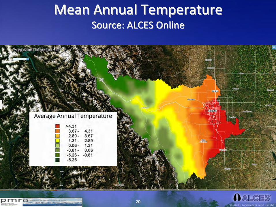
Mean Annual TemperatureMean Annual Temperature Source: ALCES OnlineSource: ALCES Online

2121
Mean Annual Precipitation (mm)Mean Annual Precipitation (mm) Source: ALCES OnlineSource: ALCES Online

2222
Mean Annual Runoff (mm)Mean Annual Runoff (mm) Source: ALCES OnlineSource: ALCES Online

2323
The Basic Math of Water in the Upper BowThe Basic Math of Water in the Upper Bow Annual Annual AnnualAnnual
Precipitation with Average Rainfall EventsPrecipitation with Average Rainfall Events
Precipitation (~780 mm)Precipitation (~780 mm)
Evapotranspiration
(~450 mm)Evapotranspiration
(~450 mm)
Runoff of Surface Water (~250 mm)Runoff of Surface Water (~250 mm)
DecadesDecades

2424
The Basic Math of Water in the Upper BowThe Basic Math of Water in the Upper Bow Annual Annual AnnualAnnual
Precipitation but Rain falls in Intense StormsPrecipitation but Rain falls in Intense Storms
Precipitation (~780 mm)Precipitation (~780 mm)
Evapotranspiration
(~450 mm)Evapotranspiration
(~450 mm)
Runoff of Surface Water (~250 mm)Runoff of Surface Water (~250 mm)
Year to YearYear to Year
Runoff of Surface Water (~450 mm)Runoff of Surface Water (~450 mm)
Evapotranspiration
(~250 mm)Evapotranspiration
(~250 mm)
2525
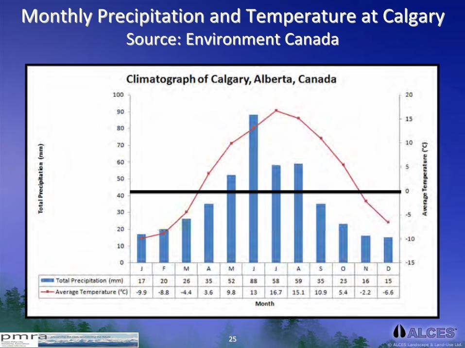
Monthly Precipitation and Temperature at CalgaryMonthly Precipitation and Temperature at Calgary Source: Environment CanadaSource: Environment Canada
2626
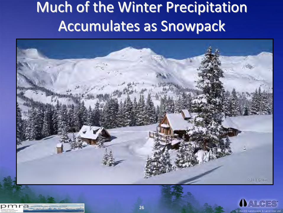
Much of the Winter Precipitation Much of the Winter Precipitation Accumulates as SnowpackAccumulates as Snowpack

2727
Average Pattern of Snowpack Accumulation and LossAverage Pattern of Snowpack Accumulation and Loss Source: Environment CanadaSource: Environment Canada
High
Rainfall
Events
Possible
High
Rainfall
Events
Possible
Under
Climate
Change
Scenarios,
High Rainfall
Events Can
Occur Earlier
in the Spring
Under
Climate
Change
Scenarios,High Rainfall
Events Can
Occur Earlier
in the Spring

2828
HowHow’’s the Snowpack this year?s the Snowpack this year? Source: Alberta Environment, AESRDSource: Alberta Environment, AESRD
2013 Snowpack2014 Snowpack
2929
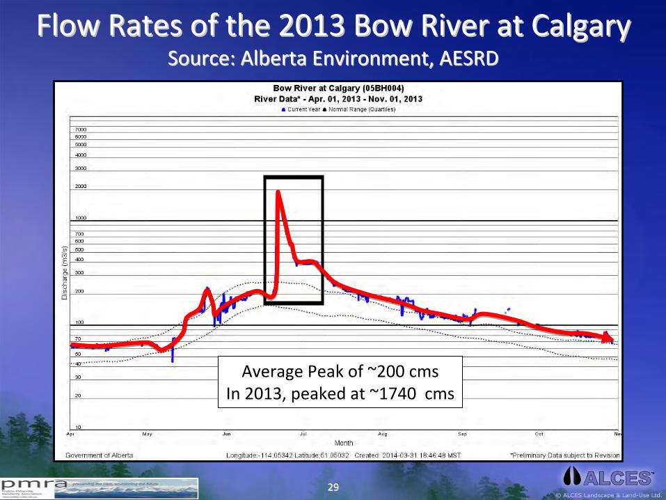
Flow Rates of the 2013 Bow River at CalgaryFlow Rates of the 2013 Bow River at Calgary Source: Alberta Environment, AESRDSource: Alberta Environment, AESRD
Average Peak of ~200 cmsIn 2013, peaked at ~1740 cms
3030
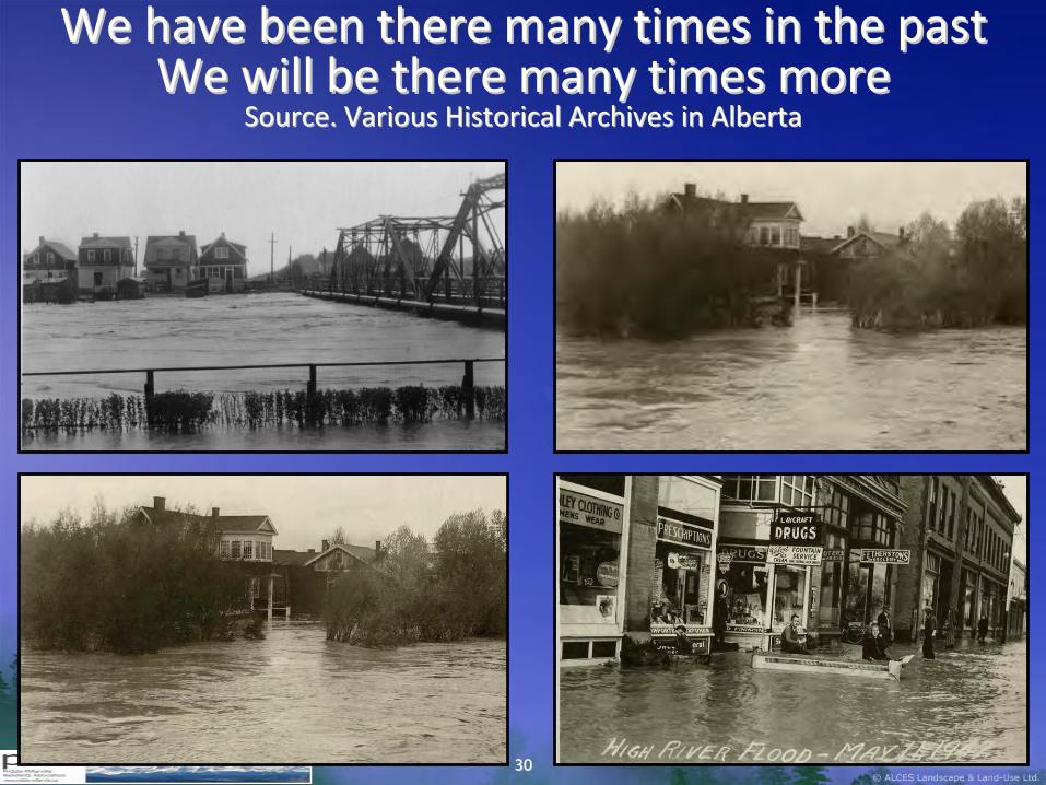
We have been there many times in the pastWe have been there many times in the pastWe will be there many times moreWe will be there many times more
Source. Various Historical Archives in AlbertaSource. Various Historical Archives in Alberta

3131
June 2013June 2013 A Very Large and A Very Large and
Concentrated Concentrated Precipitation EventPrecipitation Event

3232
Rainfall Intensity and River VolumeRainfall Intensity and River Volume
Time
RiverDischargeRate
Extended Bout of RainfallOver a 1 Week Period
A Short and Intensive RainfallEvent of a 2 –Day Period
3333
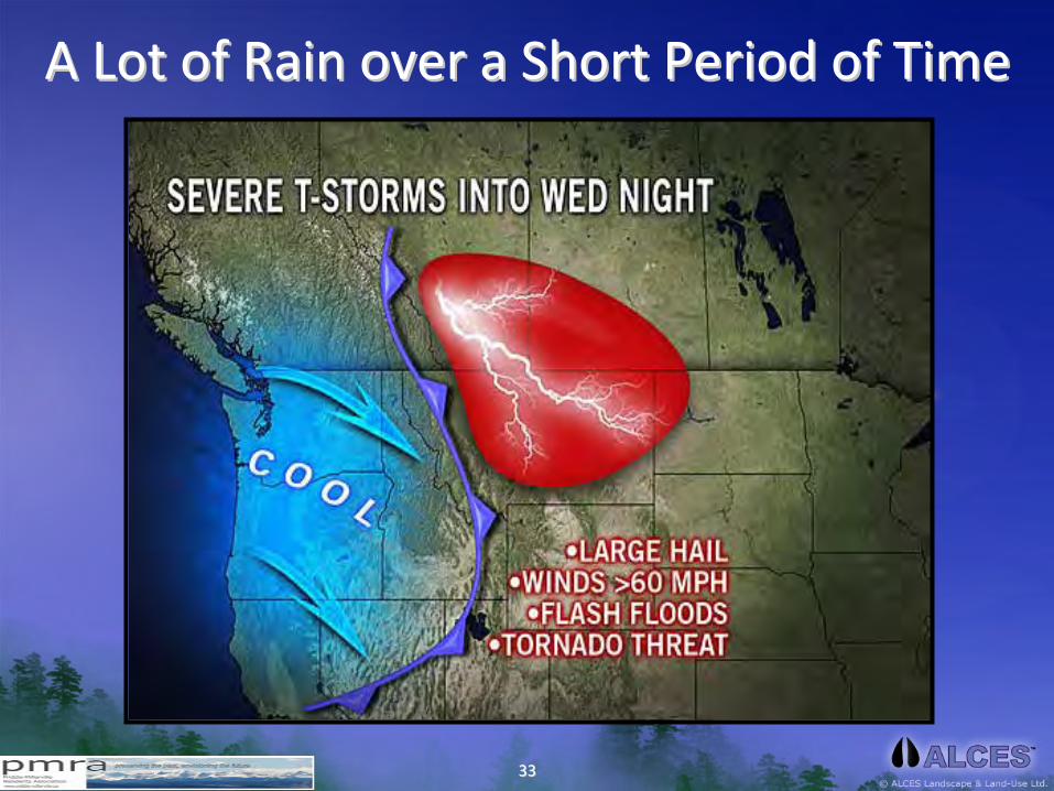
A Lot of Rain over a Short Period of TimeA Lot of Rain over a Short Period of Time

3434
Rain on SnowRain on Snow
3535
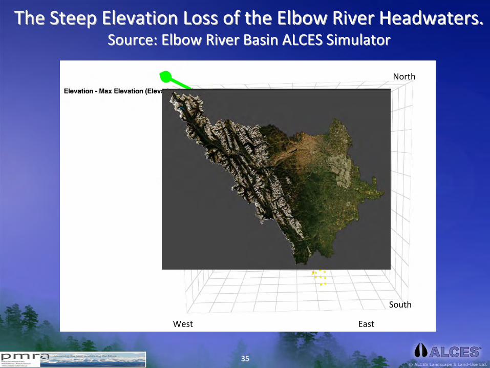
The Steep Elevation Loss of the Elbow River Headwaters.The Steep Elevation Loss of the Elbow River Headwaters.Source: Elbow River Basin ALCES SimulatorSource: Elbow River Basin ALCES Simulator
West East
South
North

3636
The Steep Elevation Loss of the Bow Basin Headwaters.The Steep Elevation Loss of the Bow Basin Headwaters.Source: Elbow River Basin ALCES SimulatorSource: Elbow River Basin ALCES Simulator
Bragg
Creek
Bragg
Creek
CalgaryCalgary
mass x slope (velocity) = energy
West
East
South
North

3737
The Steep Elevation Loss of the Elbow River Headwaters.The Steep Elevation Loss of the Elbow River Headwaters.Source: ALCES OnlineSource: ALCES Online
3838
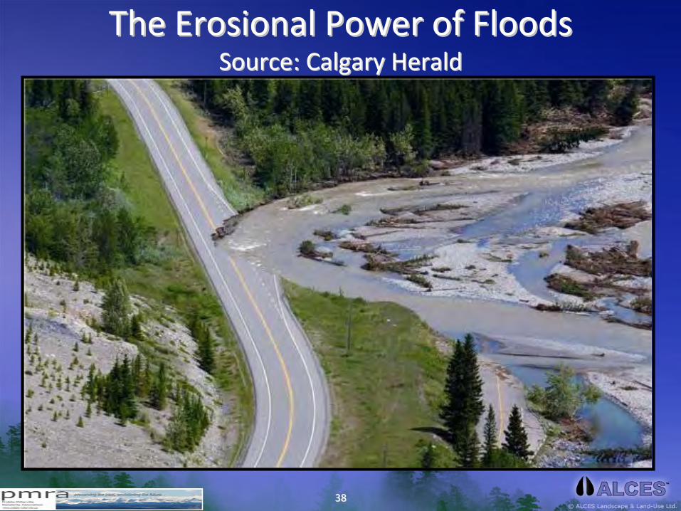
The The ErosionalErosional
Power of FloodsPower of Floods Source: Calgary HeraldSource: Calgary Herald

3939
Some Math behind the Bow River Flood EventSome Math behind the Bow River Flood Event
Variable Amount Units
4040
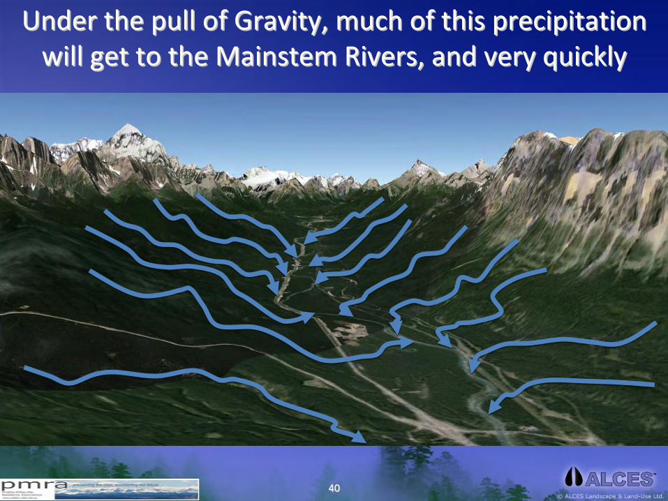
Under the pull of Gravity, much of this precipitation Under the pull of Gravity, much of this precipitation will get to the will get to the MainstemMainstem
Rivers, and very quicklyRivers, and very quickly

4141
But the But the mainstemmainstem
river systems of the Bow River river systems of the Bow River basin only amount to about basin only amount to about ¾¾
of 1% of the landscape.of 1% of the landscape.

4242
The Elbow Dissipating EnergyThe Elbow Dissipating Energy Source: Rick Source: Rick BodanBodan, , Workabove.comWorkabove.com

4343
The Elbow River and Dissipating EnergyThe Elbow River and Dissipating Energy Source: Rick Source: Rick BodanBodan, , Workabove.comWorkabove.com

4444
Bow River Basin Reservoir InfrastructureBow River Basin Reservoir Infrastructure Considerable water can be retained but primary historical purposConsiderable water can be retained but primary historical purpose has e has
been electricity generation, not flood mitigationbeen electricity generation, not flood mitigation
Minnewanka157 M m3
U. Kananaskis93 M m3
Ghost50 M m3
Glenmore25 M m3Spray
199 M m3
Bearspaw,6 M m3
Barrier,21 M m3
L.
Kananaskis58 M m3
• Most topographically suitable sites for reservoirs have already been used
• Water storage capacity is continually reduced by sedimentation
Name of ReservoirWorking Volume of Water m3

4545
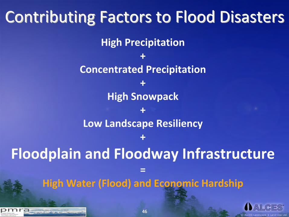
High Precipitation+
Concentrated Precipitation+
High Snowpack+
Low Landscape Resiliency=
High Water (Flood)
Contributing Factors to FloodsContributing Factors to Floods
4646
High Precipitation+
Concentrated Precipitation+
High Snowpack+
Low Landscape Resiliency+
Floodplain and Floodway Infrastructure=
High Water (Flood) and Economic Hardship
Contributing Factors to Flood DisastersContributing Factors to Flood Disasters

4747
Night Time Light EmissionNight Time Light Emission Source: Bow River Basin Source: Bow River Basin AlcesAlces
OnlineOnline

4848
Footprint Area of the Energy SectorFootprint Area of the Energy Sector Source: Bow River Basin Source: Bow River Basin AlcesAlces
OnlineOnline
~90 km2

4949
Footprint Area of the Forest SectorFootprint Area of the Forest Sector Source: Bow River Basin Source: Bow River Basin AlcesAlces
OnlineOnline
~40 km2

5050
Footprint Area of the Road SectorFootprint Area of the Road Sector Source: Bow River Basin Source: Bow River Basin AlcesAlces
OnlineOnline
~250 km2
5151
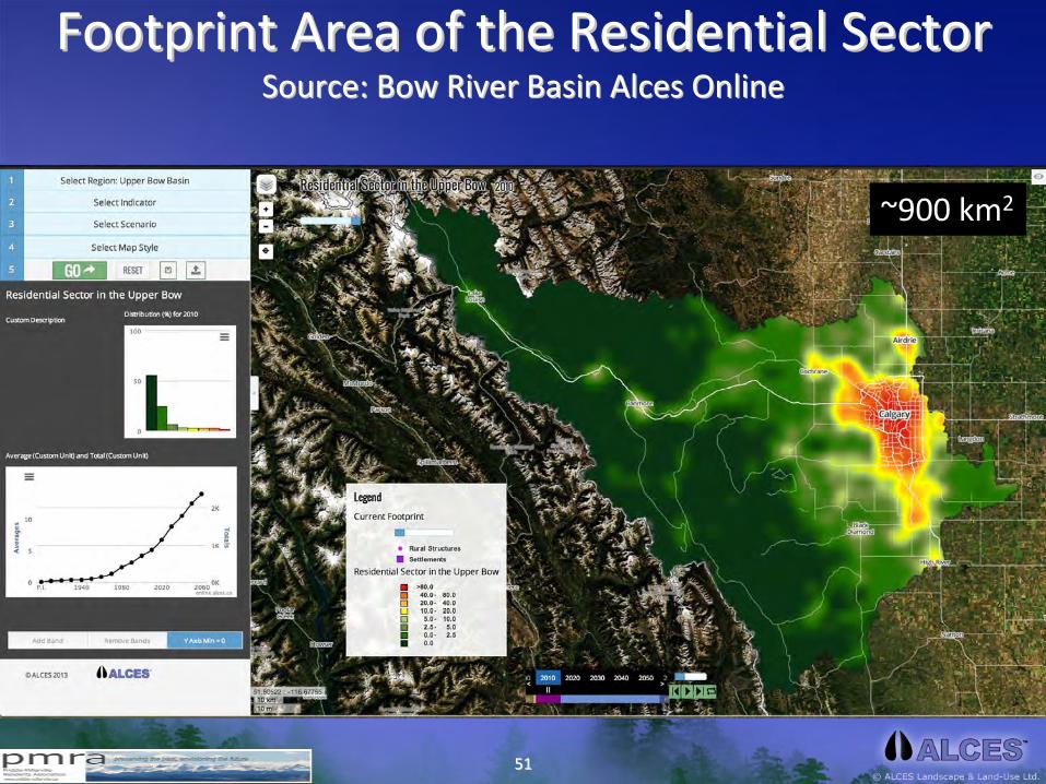
Footprint Area of the Residential SectorFootprint Area of the Residential Sector Source: Bow River Basin Source: Bow River Basin AlcesAlces
OnlineOnline
~900 km2

5252
Footprint Area of the Agriculture SectorFootprint Area of the Agriculture Sector Source: Bow River Basin Source: Bow River Basin AlcesAlces
OnlineOnline
~2,500 km2

5353
Footprint Area of All Land UsesFootprint Area of All Land Uses Source: Bow River Basin Source: Bow River Basin AlcesAlces
OnlineOnline
~3,700 km2

5454
Land Use Footprint IntensityLand Use Footprint Intensity Source: Bow River Basin Source: Bow River Basin AlcesAlces
OnlineOnline
3,700 km2
= 24%15,500 km2
2014
5,200 km2
= 34%15,500 km2
2064
Footprint km2
= %Study Area km2
Year

5555
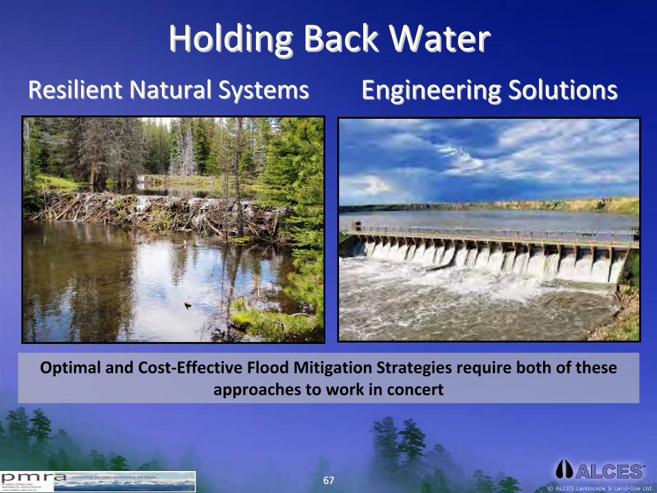
Holding Back the Water; Slowing its SpeedHolding Back the Water; Slowing its Speed

5656
Holding Back the Water; Slowing its SpeedHolding Back the Water; Slowing its Speed Photo Credit: Jenny EarlePhoto Credit: Jenny Earle

5757
The The Role of Wetlands in Flood MitigationRole of Wetlands in Flood Mitigation Source: Source: MitschMitsch
and and GosselinkGosselink))

5858
Loss of Wetlands in the East SlopesLoss of Wetlands in the East SlopesPre‐Industrial 2010
2060

5959
We are Losing Natural Wetland StorageWe are Losing Natural Wetland Storage
6060
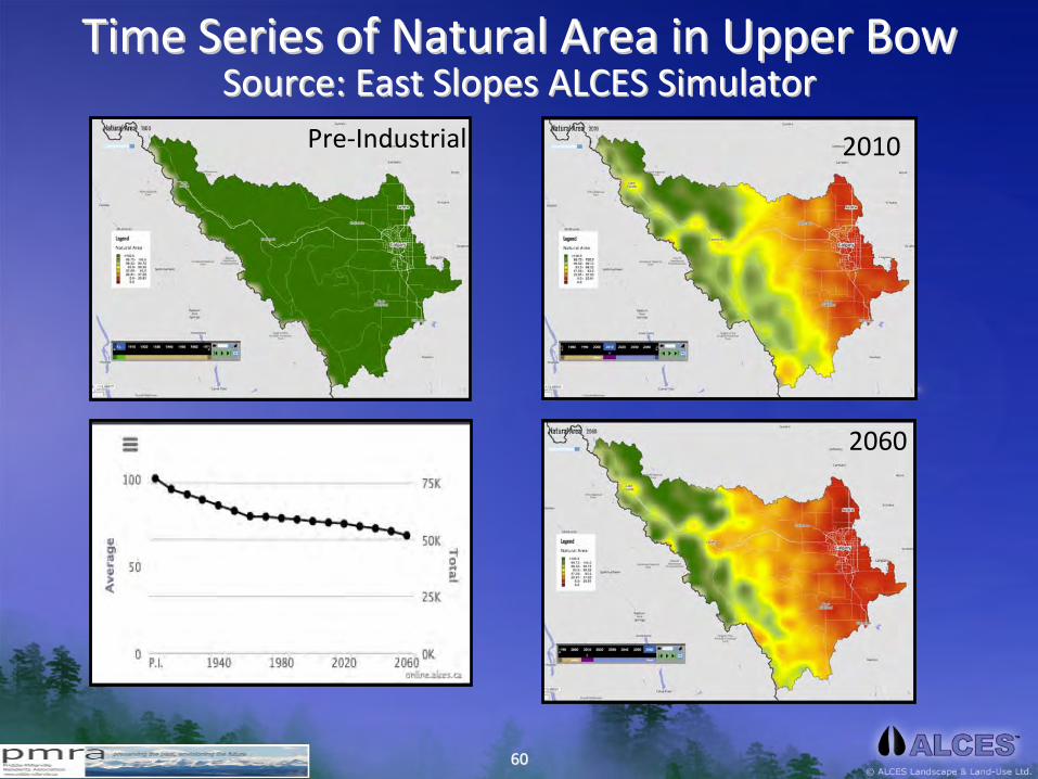
Time Series of Natural Area in Upper BowTime Series of Natural Area in Upper Bow Source: East Slopes ALCES SimulatorSource: East Slopes ALCES Simulator
Pre‐Industrial 2010
2060
6161
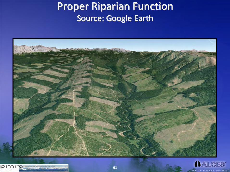
Proper Riparian FunctionProper Riparian Function Source: Google EarthSource: Google Earth

6262
Land Use and Flashy RunoffLand Use and Flashy Runoff
In comparison to natural ecosystems, roads,
settlements, acreages, cutblocks, croplands,
pasturelands, and industrial features generally
increase the pace (rate) at which precipitation runs off
landscapes.

6363
In Harms WayIn Harms Way
6464
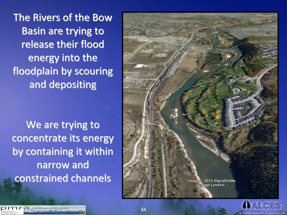
The Rivers of the Bow The Rivers of the Bow Basin are trying to Basin are trying to
release their flood release their flood energy into the energy into the
floodplain by scouring floodplain by scouring and depositingand depositing
We are trying to We are trying to concentrate its energy concentrate its energy
by containing it within by containing it within narrow and narrow and
constrained channels constrained channels

6565
Flooding in Flooding in CanmoreCanmore

6666
Flooding in High RiverFlooding in High River Source: Source: www.outdoorsmenforum.cawww.outdoorsmenforum.ca
6767
Holding Back WaterHolding Back WaterResilient Natural SystemsResilient Natural Systems Engineering SolutionsEngineering Solutions
Optimal and Cost‐Effective Flood Mitigation Strategies require both of these
approaches to work in concert
6868
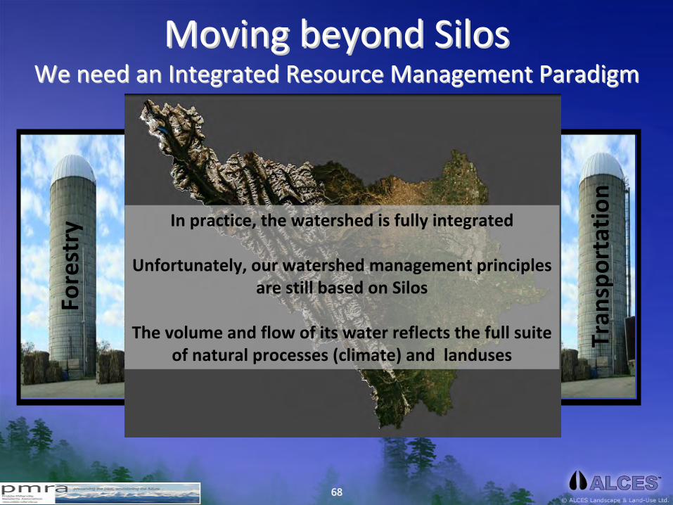
Moving beyond SilosMoving beyond Silos We need an Integrated Resource Management ParadigmWe need an Integrated Resource Management Paradigm
Forestry
Energy
Crop
s
Livestock
Reside
ntial
Mining
Reservoirs
Tran
sportatio
n
In practice, the watershed is fully integrated
Unfortunately, our watershed management principles
are still based on Silos
The volume and flow of its water reflects the full suite
of natural processes (climate) and landuses
6969
Summary ThoughtsSummary Thoughts• Precipitation is, by nature, highly variable in time (seasons, years, decades)
• Floods are a natural, and required, process for all healthy watersheds
• Climate Change models suggest that variation in precipitation (floods, droughts)
will increase in frequency and intensity
• The resiliency of the Bow River Watershed to absorb and hold meltwater
has been
impaired by land uses (forestry, agriculture, transportation, residential)
• Human infrastructure (crops, forestry, residential, transportation) has accelerated
the rate of water movement to mainstem
rivers
• We have intentionally constructed many billions of $ of infrastructure in the flood
plain of the Bow River Basin mainstem
rivers and its tributaries
• Although engineering solutions play a key role in flood mitigation, longterm
and
sustainable solutions to flood risk must incorporate a landscape
(watershed) level
• We should be looking for silver buckshot, not a silver bullet. We are all part of both
the problem and the solution.

7070
What Can We Do Now to Mitigate Flood Risk?What Can We Do Now to Mitigate Flood Risk?1.
Where possible, remove high‐risk infrastructure from the flood
plain
2.
Stop approving and building new infrastructure in the flood plain
3.
Relocate (elevate) valuables and key utilities (furnaces, water heaters, electrical controls) from basements;
4.
Restore natural river function and flow
5.
Promote the reconstruction of wetlands and riparian function
6.
Promote forestry practices (and other land uses) that encourage water retention in the headwater forest ecosystems
7.
Require, and support, regional planning initiatives that promote resilient watersheds

7171
Implications to MD FoothillsImplications to MD Foothills

7272
7373
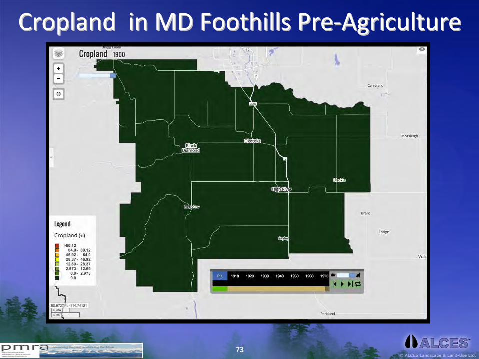
Cropland in MD Foothills PreCropland in MD Foothills Pre‐‐AgricultureAgriculture

7474
Cropland in MD Foothills 2014Cropland in MD Foothills 2014
7575
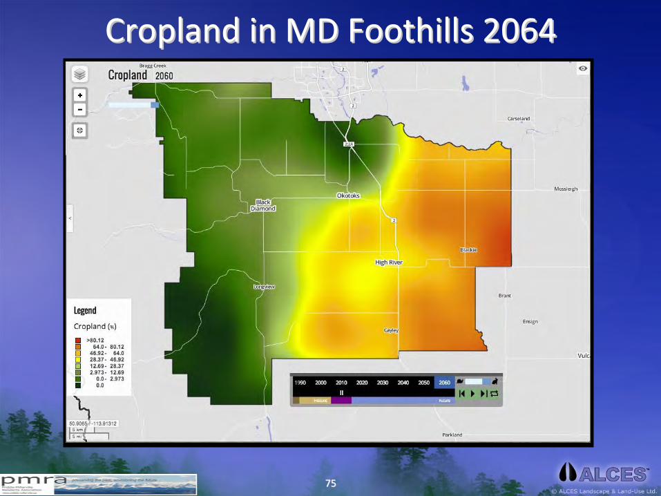
Cropland in MD Foothills 2064Cropland in MD Foothills 2064

7676
Cropland Trajectory in MD FoothillsCropland Trajectory in MD Foothills

7777
Pasture in MD Foothills PrePasture in MD Foothills Pre‐‐AgricultureAgriculture

7878
Pasture Land in MD Foothills 2014Pasture Land in MD Foothills 2014

7979
Pasture Land in MD Foothills 2064Pasture Land in MD Foothills 2064

8080
Pasture Trajectory in MD FoothillsPasture Trajectory in MD Foothills

8181
Human Human PopnPopn
in MD Foothills (pre)in MD Foothills (pre)
8282
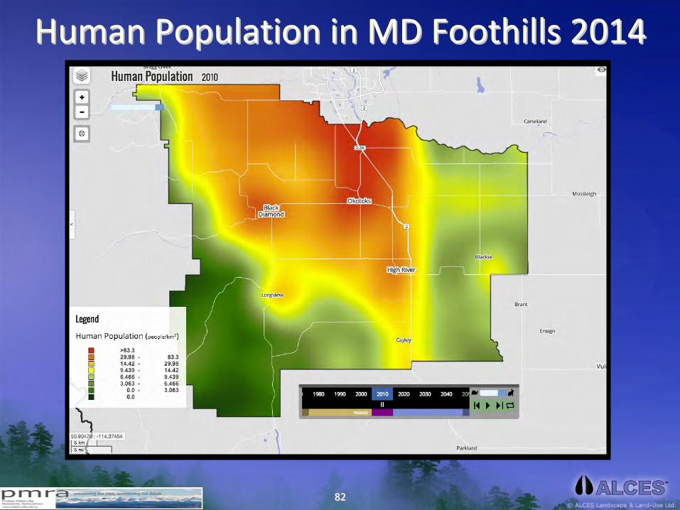
Human Population in MD Foothills 2014Human Population in MD Foothills 2014

8383
Human Population in MD Foothills 2064Human Population in MD Foothills 2064

8484
Human Human PopnPopn
Trajectory in MD FoothillsTrajectory in MD Foothills
8585
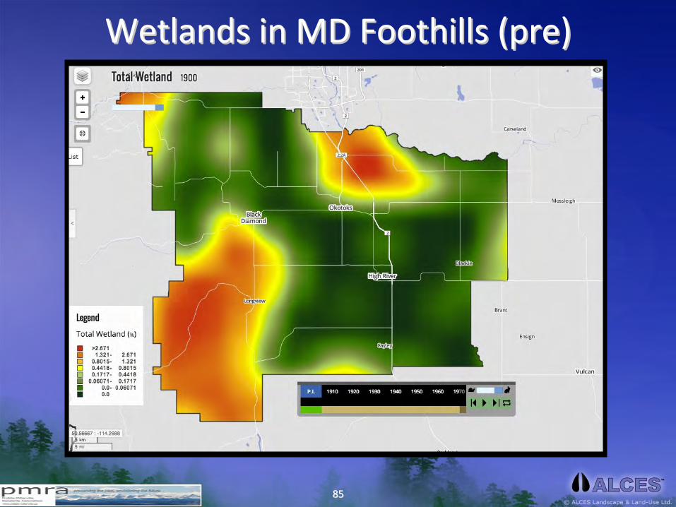
Wetlands in MD Foothills (pre)Wetlands in MD Foothills (pre)

8686
Wetlands in MD Foothills 2014Wetlands in MD Foothills 2014

8787
Human Population in MD Foothills 2064Human Population in MD Foothills 2064

8888
Wetland Trajectory in MD FoothillsWetland Trajectory in MD Foothills

8989