understanding arcsde - esridownloads.esri.com/support/documentation/sde_/706understanding_… ·...
TRANSCRIPT

GIS by ESRI®
Understanding ArcSDE®

Copyright © 1999–2004 ESRI
All rights reserved.
Printed in the United States of America.
The information contained in this document is the exclusive property of ESRI. This work is protected under UnitedStates copyright law and other copyright treaties and conventions. No part of this work may be reproduced or transmittedin any form or by any means, electronic or mechanical, including photocopying and recording, or by any informationstorage or retrieval system, except as expressly permitted in writing by ESRI. All requests should be sent to Attention:Contracts Manager, ESRI, 380 New York Street, Redlands, CA 92373-8100, USA.
The information contained in this document is subject to change without notice.
U.S. GOVERNMENT RESTRICTED/LIMITED RIGHTS
Any software, documentation, and/or data delivered hereunder is subject to the terms of the License Agreement. In noevent shall the U.S. Government acquire greater than RESTRICTED/LIMITED RIGHTS. At a minimum, use, duplication,or disclosure by the U.S. Government is subject to restrictions as set forth in FAR §52.227-14 Alternates I, II, and III(JUN 1987); FAR §52.227-19 (JUN 1987) and/or FAR §12.211/12.212 (Commercial Technical Data/Computer Software);and DFARS §252.227-7015 (NOV 1995) (Technical Data) and/or DFARS §227.7202 (Computer Software), as applicable.Contractor/Manufacturer is ESRI, 380 New York Street, Redlands, CA 92373-8100, USA.
ESRI, SDE, ArcView, MapObjects, the ESRI globe logo, ArcInfo, ArcSDE, ArcCatalog, ArcGIS, ArcMap, ArcIMS,ArcObjects, Avenue, ArcStorm, Spatial Database Engine, ArcEditor, ArcPlot, ArcInfo Librarian, GIS by ESRI, theArcExplorer logo, the ArcView logo, the ArcInfo logo, the ArcIMS logo, the ArcSDE CAD Client logo, the MapObjectslogo, and www.esri.com are trademarks, registered trademarks, or service marks of ESRI in the United States, theEuropean Community, or certain other jurisdictions.
Other companies and products mentioned herein are trademarks or registered trademarks of their respective trademarkowners.

iii
Contents
INTRODUCING ARCSDE ........................................................................................... 1
What is ArcSDE? ............................................................................................................................. 2Why ArcSDE? ................................................................................................................................... 3ArcSDE connection configuration options ................................................................................. 5ArcSDE for developers ................................................................................................................... 6
DATA STORAGE .............................................................................................................. 7
Data storage with ArcSDE ............................................................................................................ 8Organizing features .......................................................................................................................... 9Types of features ............................................................................................................................ 10Feature storage ................................................................................................................................ 11Geometry storage options ............................................................................................................. 13Spatial indexing .............................................................................................................................. 14Relational access and object relational access ........................................................................... 15Vector tables .................................................................................................................................... 16Raster tables .................................................................................................................................... 17
THE ARCGIS GEODATABASE .................................................................................. 19
The ArcGIS geodatabase .............................................................................................................. 20What is the geodatabase? .............................................................................................................. 21Geodatabase architecture ............................................................................................................. 22Accessing and using geodatabase application logic .................................................................. 23Vector data ...................................................................................................................................... 24Raster data ....................................................................................................................................... 25Geodatabase storage in relational databases ............................................................................. 26Versioned geodatabases and distributed work flows ............................................................... 27

iv • Understanding ArcSDE
THE ARCSDE ARCHITECTURE .............................................................................. 29
What is an application server? ..................................................................................................... 30Direct connections ......................................................................................................................... 32Connecting with a direct connect driver ................................................................................... 33Licensing and authorization ......................................................................................................... 34
ARCSDE FOR COVERAGES ...................................................................................... 35
Introducing ArcSDE for Coverages ............................................................................................ 36ArcSDE for Coverages .................................................................................................................. 37
WHERE TO GO NEXT ............................................................................................... 39
Administrators ................................................................................................................................ 40Developers ....................................................................................................................................... 41End users ......................................................................................................................................... 42ArcSDE resources .......................................................................................................................... 43

1
11111 IntrIntrIntrIntrIntroducingoducingoducingoducingoducingArArArArArcSDEcSDEcSDEcSDEcSDE
ESRI® ArcSDE® is the geographic informationsystem (GIS) gateway to relational databases.It allows you to choose the relational databasemanagement system (DBMS) you want touse in your organization to fully integrate GISand DBMS. This book provides an overview ofwhat ArcSDE is and how it works.
In this chapter:
• What is ArcSDE?
• Why ArcSDE?
• Configuration options
• ArcSDE for developers

2 • Understanding ArcSDE
WHAT IS ARCSDE?
Welcome to ArcSDE, the GIS gateway to your DBMS.ArcSDE is the software that allows you to use thefollowing ESRI products:
� ArcGIS® suite (Desktop, Server, Engine)
� ArcIMS®
� ArcInfo� Workstation
� ArcView®
� ArcSDE CAD Client
� MapObjects® and MapObjects®�Java�
to store, use, and manage all your GIS data (includingfeature geometry) in one of the following commercialDBMSs:
� IBM® DB2®
� IBM Informix®
� Microsoft® SQL Server�
� Oracle®
on your choice of several operating systems and scalingfrom work groups to large enterprise databases. It alsoprovides other choices for developing custom applicationsas well as how the geometry of your features is stored.
ArcSDE acts as the gateway between ArcGIS and your relational database. This graphic illustrates several ways to configure ArcSDE.
DBMS
ArcSDE
ArcView
ArcSDEArcSDE
ArcEditorArcInfo
DBMS
ArcSDE
ArcIMSServer
ArcSDE
ArcGISServer
DBMS
ArcSDE
ArcView
ArcSDEArcSDE
ArcEditorArcInfo
ArcSDE is a key component in a multiuser GIS because itallows you to �marry� world-class GIS technology withworld-class relational database management systemtechnology. You get to use what a GIS does best alongwith what a DBMS does best. The combination providesyou with:
� Support for concurrent multiuser editing with longtransactions, allowing support for many editing andcritical GIS data management work flows.
� No limits on the size of your spatial database.
� The ability to serve many concurrent users anywhere onthe network or the Internet.
� The ability to build custom applications from theArcSDE C and Java application programming interfaces(APIs) as well as ArcGIS, ArcObjects, and ArcIMS.
� A number of configuration choices.
All of this multi-DBMS, multiplatform/OS, multiclient,and multiple developer choice flexibility adds up to anopen, scalable solution, with more choices for users andbetter interoperability.
In this book, you�ll get an overview of what ArcSDE isfor and how it relates to the ArcGIS geodatabase, as wellas a review of how ArcSDE works and where to go nextfor more in-depth information for deploying a system withArcSDE.
Introducing ArcSDE • 3
WHY ARCSDE?
A common question to ask is: Do I need ArcSDE?Answering that requires answering another question first:Do I need a DBMS?
If you are unfamiliar with DBMS technology, here is avery brief overview. Please consult with DBMS vendorsto get more information on their particular product.Chapter 2 goes into a little more detail on how data isstored in a DBMS.
Why use a DBMS?
Multiuser GIS requires DBMS and comprehensive GIStools that work with the geographic data. As yourorganization evolves, your spatial databases will grow insize and number of users. Using a DBMS is a practicalmeans for sharing and protecting your data investments.
For years, file-based formats have been used to manageand share information using coverages, shapefiles, grids,TINs, CAD drawings, and many raster formats. Therewere some clear advantages to doing this. First, it was easyand inexpensive. Everyone could edit and manage file-based data. No DBMS investment was necessary. Plus,DBMSs lacked the ability to manage the larger, morecomplex data types and support for operations required byGIS. In recent years, however, the use of DBMS in GIShas become more widespread.
As DBMS capability has evolved into more powerfultechnology that could support complex data objects, largerqueries, and stronger transactional support, the use ofDBMS for geographic data management has become muchmore practical. Most multiuser GIS systems today managetheir GIS data in a DBMS, and many smaller sites arebeginning their migration to a DBMS.
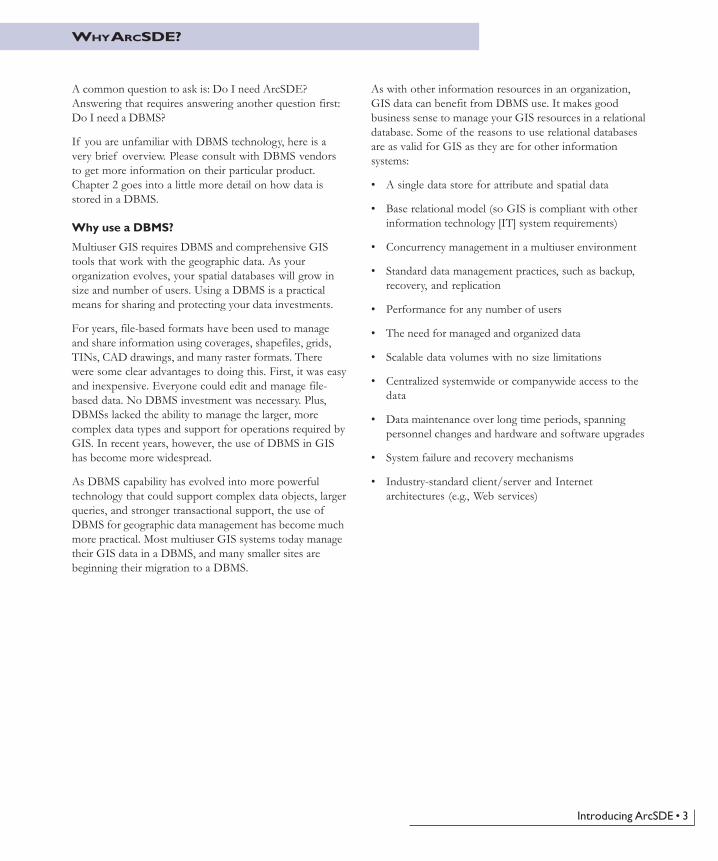
As with other information resources in an organization,GIS data can benefit from DBMS use. It makes goodbusiness sense to manage your GIS resources in a relationaldatabase. Some of the reasons to use relational databasesare as valid for GIS as they are for other informationsystems:
� A single data store for attribute and spatial data
� Base relational model (so GIS is compliant with otherinformation technology [IT] system requirements)
� Concurrency management in a multiuser environment
� Standard data management practices, such as backup,recovery, and replication
� Performance for any number of users
� The need for managed and organized data
� Scalable data volumes with no size limitations
� Centralized systemwide or companywide access to thedata
� Data maintenance over long time periods, spanningpersonnel changes and hardware and software upgrades
� System failure and recovery mechanisms
� Industry-standard client/server and Internetarchitectures (e.g., Web services)

4 • Understanding ArcSDE
The right tool for the job
Responsibility for management of geographic datasets isshared between GIS software and generic relationaldatabase management system software. Certain aspects ofgeographic dataset management, such as disk-basedstorage, definition of attribute types, associative queryprocessing, and multiuser transaction processing, aredelegated to the DBMS. Some DBMS engines have beenextended with support for spatial types, with associatedindexing and search functionality.
The GIS application retains responsibility for defining thespecific DBMS schema used to represent variousgeographic datasets and for domain-specific logic, whichmaintains the integrity and utility of the underlyingrecords. In effect, the DBMS is used as an implementationmechanism for geographic datasets.
ArcSDE is part of the multitier architecture (applicationand storage), where aspects related to data storage andretrieval are implemented in the storage (DBMS) tier,while high-level data integrity and information processingfunctions are retained in the application and domainsoftware (for example, ArcGIS).
ArcSDE enables the same capabilities on allDBMSs
Although all relational database vendors support SQL andprocess SQL queries in similar ways, there are significantdifferences among database vendors in the details of theirdatabase server implementation. These relate toperformance and indexing, the supported data types, theintegrity management tools, and the execution of complexqueries. These also relate to support for spatial types in theDBMS.
Standard SQL does not support spatial data. The ISOSQL/MM Spatial and OGC�s simple feature SQLspecifications extend SQL by defining standard SQLlanguage for vector geometry types. DB2 and Informixsupport these standard SQL types. Oracle hasimplemented its own spatial type, while Microsoft SQLServer has no spatial type support. Spatial geometry inMicrosoft SQL Server is stored as type �image�. ArcSDEprovides the flexibility to leverage the capabilities thateach DBMS vendor offers so client applications will workthe same regardless of what spatial storage method is used.
ArcSDE ensures that full spatial functionality is available
regardless of the capabilities in the underlying DBMS. Forexample, if you build an ArcGIS application usingArcSDE for Oracle, that same application will work ifused with ArcSDE for IBM DB2, Informix, or MicosoftSQL Server.
One of the roles of ArcSDE is to deal with the diversityand complexity in the underlying DBMS. ArcSDE is like an�adapter� for client applications to use when they want tostore and manage their spatial data in a commercial DBMS.A client application is built using the ArcSDE API, and thatclient application, with little or no modification, can workon any one of the four DBMSs or spatial storage methodssupported by the host DBMS.
Fitting GIS into an IT strategy
Many GIS users require that their GIS fits into a coherentinformation technology strategy for their organization.Simply put, their GIS must adhere to IT standards, the GISdata should be managed as an integral part of theorganization�s valuable data holdings, the data must besecure, and access to the data must be restricted to onlythose users that need it. These are standard advantages of aDBMS that GIS users need. Since ArcSDE provides themeans for storing and using GIS data in an DBMS withvarious GIS and non-GIS applications, ArcSDE plays animportant role in fitting GIS into an IT strategy.
Data interoperability in ArcSDE
Data interoperability is the ability of multiple applicationsto use the same data. Sometimes that data is shared by themultiple applications, and sometimes interoperability tools(translators) are required. Many sites have multipleapplications using the same data, so interoperability is animportant issue. Other sites have multiple applications usingdifferent data types, so it�s important that applications beable to use them all.
ArcSDE also plays a role in GIS data interoperability by useof spatial types in IBM DB2, IBM Informix, and Oracle.Sites can, for example, use Oracle Spatial or Locatorproducts as the spatial geometry storage method, allowingESRI�s ArcSDE client applications, as well as non-ESRIapplications, to use the same spatial data without making acopy of it as long as both applications follow the hostDBMS�s interoperability rules for application development.

Introducing ArcSDE • 5
The ArcSDE gateway can be multitier and will run as partof a GIS client application or in a centralized server.ArcSDE can be flexibly configured to connect clientapplications directly to a DBMS (a two-tier configuration)or to run as an application server near the DBMS (a three-tier configuration). There are advantages to eachconfiguration, depending on your needs.
Direct connection configuration
This configuration is useful in many situations because itallows for increased scalability by offloading work fromthe server to each connected client. It also can be useful inmany failover environments because it reduces the numberof single points of failure.
Application server configuration
Currently, the most common ArcSDE configurationincludes an ArcSDE Application Server. The applicationserver allows you to serve geographic data from a large,central geodatabase on UNIX, Linux®, and Windows®
servers. The ArcSDE Application Server is typicallylocated on the same hardware platform as your DBMS,ArcIMS, or ArcGIS Server. The application serverconfiguration can offer performance advantages; duringediting, it may be faster due to the intelligent client/serverdata communications.
See Chapter 4, �The ArcSDE architecture�, for moreinformation about two-tier and three-tier configurations.
ArcSDE has both a direct connection configuration and an application server configuration, as shown in the graphics above.
ARCSDE CONNECTION CONFIGURATION OPTIONS
DBMS
ArcSDE
ArcView
ArcSDEArcSDE
ArcEditorArcInfo

6 • Understanding ArcSDE
ARCSDE FOR DEVELOPERS
ArcSDE comes with high-level APIs for querying andworking with information in geodatabases. These include:
� ArcSDE Client API for C and Java developers
� COM API (ArcObjects) for use with the ArcGIS suiteof products
ArcSDE Client API
ArcSDE ships with an ArcSDE Developer Kit CD�ROM.This CD�ROM has C and Java SDK from whichapplications can be built. The ArcSDE Client APIprovides many advanced GIS functions. All ESRI clientapplications that work with the ArcSDE gateway (forexample, ArcGIS) use either the C or Java API. ArcSDEclient applications, such as ArcGIS, are large and use agreat deal of the available ArcSDE API. If you arebuilding custom applications from one of these ESRIproducts (for example, ArcGIS Engine), you won�t needto use the C or Java API. You�ll use ArcObjects (with oneof the ArcGIS Application Development Frameworks).Non-ESRI client applications can be built using a smallportion of the API to build small, focused, mission-criticalapplications�for example, in emergency response andcustomer care.
These two ArcSDE APIs allow developers to buildcustom applications to work with any DBMS supportedby ArcSDE. ArcSDE has a significant third-partydeveloper community providing application solutions formany industries.
ArcObjects
If you want to build or customize an ArcGIS application,you�ll use ArcObjects. ArcObjects is the COM developer�sAPI for ArcGIS Desktop, Server, and Engine. It providesthe ability to access and work with the contents ofArcGIS geodatabases as objects with advanced GISbehavior and relationships. A Java ADF and a .NET ADFare available for use with ArcObjects. Refer to ArcGISdocumentation for more information on ArcObjectsdevelopment.
SQL
There are SQL APIs available for working with spatialdata. The SQL interface provided by your DBMS can beused to work with the contents of spatial databases. Sincespatial databases use standard DBMS columns, theDBMS�s SQL API is used. For a spatially enabled DBMS(for example, IBM DB2, IBM Informix, and OracleSpatial/Locator), a SQL API is available to performspatial queries directly in the database. This allows SQLquery access to feature geometry using DBMS applications.See your host DBMS documentation for spatial query SQLsyntax.

7
2 Datastorage
This chapter is targeted for databaseadministrators and application developers andprovides an overview of the ArcSDE simplefeature model and how data is stored.
In this chapter:
• Using a DBMS
• Organizing features
• Types of features
• Feature storage
• Geometry storage options
• Spatial indexing
• Relational access and object relationalaccess
• Vector and raster tables

8 • Understanding ArcSDE
DATA STORAGE WITH ARCSDE
This chapter reviews the basics of the ArcSDE simplefeature model and how the data is physically stored in theDBMS. This chapter is an important building block forunderstanding the overview of the ArcGIS geodatabase inChapter 3, �The ArcGIS geodatabase�.
The first thing you should know is that data is neverstored in ArcSDE. Data is stored in tables in a DBMS.ArcSDE is the tool that allows you to use that data withGIS applications.
Second, all data is stored in standard DBMS tables usingdata types available for the host database. ArcSDE usesand complements the base DBMS capability by adding aspatial component to the database. A key part of usingArcSDE is tuning the host DBMS. There can be manyperformance variables, but ArcSDE performance hingeslargely on how well the host database is tuned.
Key DBMS concepts
In a relational database management system model, data isstored in tables consisting of rows and columns. The celldefined by the intersection of a row and column is called afield; the data contained in the field is a value. A rowrepresents a particular occurrence, or instance, of afeature, while the columns contain the attributes of thefeature, such as owner name for a parcel. Attributes canhave many types, such as dates, text strings, or numbers. Ageometric shape of a feature is another type of value,stored in a column that defines an abstract geometric datatype.
SQL provides an interface to relational tables that allowsyou to select rows based on the values contained in thefields. A SQL statement can range from simple tocomplex, allowing you to compose virtually any type ofquery from basic column types.
A query may return columns from any number of tables byjoining the tables together on key columns. A primary key(one or more columns) uniquely identifies rows in a table.The same column or columns, duplicated in another table,is called the foreign key. These keys allow tables to bejoined.
The result of a query is a set of rows meeting the criteriaestablished by the SQL statement. This set is called acursor. An application can reference a number of activecursors. The application proceeds through a cursor,looking at each individual row. As each successive row is
primary key
foreign key
2 arterial or collector roads
1 divided highway
3 major roads
4 residential streets
code description
5 unpaved roads
fid geom shp_len type surface width lanes name
103 2321.8 3 asphalt 75.9 4 Caitlin County Road
101 4507.2 2 asphalt 85.3 4 Old Taos Highway
102 3401.1 1 concrete 45.1 2 Calle Mejia
104 689.2 5 gravel 35.2 2 Max Daniel Road
object identifiergeometrygeometry-tracking fieldcoded valuedescriptive stringcontinuous numeric valuediscrete numeric valuename
requested, the appropriate values of each field are madeavailable to the application.
ArcSDE extends SQL by providing tools to work withspatial data. You can also use standard SQL queries inArcSDE API to perform attribute-only queries.

Data storage • 9
Organizing geographic features
ArcSDE organizes features in layers or feature classes. Afeature class is a collection of one or more features of onegeometric type. A feature is a geometric representation ofa spatial object (for example, a road is represented in thedatabase as a line feature), defined as a sequence of one ormore x,y coordinates and the attributes for that geometry.Features are stored so that one row in a table equals onefeature.
Users may logically think of a feature class as one singletable. However, ArcSDE implements a feature class asone or more tables, depending on the DBMS, the columntype used for storing the geometry, and whether or not thedata will be used in long transactions.
ArcSDE doesn�t change existing DBMSs or affect currentapplications. It simply adds a spatial column to tables andprovides tools (an API) for a client application, such asArcMap, to manage and access the geometry datareferenced by that column.
When you add a spatial column to a table (sometimesreferred to as a business table), you spatially enable it. TheArcSDE software manages spatially enabled tables bystoring information, such as the name of a feature class; itsowner; x,y extent; type of geometry allowed in the layer;and many other pieces of information in ArcSDEmetatables. These ArcSDE metatables are stored in thehost DBMS and are created when ArcSDE is installed.They are owned, managed, and populated exclusively byArcSDE. The schema of these tables is available in theArcSDE Developer Help (located on the ArcSDEDeveloper Kit CD�ROM). Under no circumstancesshould any ArcSDE metatable be directly modified withSQL. These tables are managed totally by ArcSDE.
ORGANIZING FEATURES
Object
Attribute
Class
Row
Column, Field
Table
Database elementsLogical elements

10 • Understanding ArcSDE
TYPES OF FEATURES
This chapter has discussed features in a table. So whatgeometry types are supported with ArcSDE? Thefollowing graphic illustrates the feature geometries youmay store in your DBMS with ArcSDE.
Basic feature storage
ArcSDE stores geometric shapes as x,y coordinates andtrue curves. Points are recorded as a single x,y coordinate,lines as a series of ordered x,y coordinates and curves, andareas as sets of lines composed of x,y coordinates andcurves that have the same starting and ending point.
Every geometry type in ArcSDE has a set of strictverification rules that determine whether a geometry isgeometrically correct before it is stored. Verification rules
Single-part polylinePoint
Multipart polylineMultipoint
Single-part polygon
Multipart polygon
ArcSDE stores a list of x,y coordinates that define the locationand shape of each geographic feature.
•3,2
8,4
5,1 11,1
13,48,4
6,8
2,3
Point
Areachord height
from-point
to-point
1,1 5,1
7,511,7
Line
circular arc
12,6
radius
for each shape type are described in the ArcSDEDeveloper Help (available on the ArcSDE Developer KitCD�ROM).
These simple features that ArcSDE stores in a DBMS arethe building blocks on which the ArcGIS geodatabase isbuilt.

Data storage • 11
Z-values
ArcSDE allows you to add z-values to the x,y coordinates.Z-values can represent height or depth. Geometry may beeither two-dimensional (x,y) or three-dimensional (x,y,z).
Measures
Measures represent a distance, time, address, or some otherevent at given points along a feature. You can add measurevalues (m-values) to any geometry type. Identifying anevent by road name and distance from a known location(for example, Highway 20, kilometer 38) is a commonmethod for locating highway information, such as sign oraccident locations, exit ramps, pavement quality, andspeed zones.
Measure values are independent of a geometry�scoordinate system. The x,y coordinate of a point could be(529482, 5109382) with a measure value of 248.Although many applications use measures to representincreasing linear distances along a line (see the graphicabove), measure values can arbitrarily increase, remainconstant, or decrease.
Like z-values, geometry can contain a measure value(x,y,m). You could also have four-dimensional geometry byadding z- and m-values to the geometry (x,y,z,m).
ArcSDE annotation
Annotation is text that labels features for cartographicdisplay. It helps identify places and features. For example,a road map can have labels that identify the names of theroads, the distances between intersections, and so on.
Annotation is a feature attribute. ArcSDE storesannotation as a feature attribute to ensure a direct linkbetween the text and the feature it labels. Annotationproperties can be stored in a single binarly large object(BLOB) column as part of the feature table, or they canbe stored in one or more related tables. See the ArcSDEDeveloper Help for more details on annotation.
Annotation is usually thought of as text attached to afeature or coordinates on a map. Maps often include othertext to label nongeographic map components, such as keylegends, map titles, North arrows, and scalebars. This texthas no geographic coordinates and isn�t stored by ArcSDE.
ArcSDE annotation is not the same as ArcGISgeodatabase annotation. Refer to Building a Geodatabase tocreate and maintain geodatabase annotation. ArcGISDesktop applications can view ArcSDE annotation butcannot edit it. If you need to edit your annotation withArcEditor�, for example, you will need to convert yourArcSDE annotation to the ArcGIS geodatabaseannotation format.
FEATURE STORAGE
Measures on a simple line shape mark traffic accidents on a highway.
2868 101 248
294
280460
1,020
26040 40
Z-values, such as elevations or depths, can be stored in a feature�sgeometry. In this case, points on a mountain have z-valuescontaining their elevation, in addition to their x,y position.
3750 3752 3754 3756 3758
3751 3753 3755 3757 3759
Santa Anna Ave
The street name and the addresses are attached to the street andparcel features, respectively.

12 • Understanding ArcSDE
CAD data
ArcSDE layers can also contain CAD entities, with the aidof ArcSDE CAD Client. When a CAD entity is stored in alayer, an ArcSDE feature representing the entity is alsostored. Only ArcSDE CAD Client can work with CADentities, but other ArcSDE client applications can use thecorresponding features. Refer to �Using ArcSDE CADClient� (usingcadclient.pdf in the documentation folder ofthe ArcSDE Developer Kit CD�ROM) for moreinformation.
XML data
Much like ArcSDE extends traditional DBMSfunctionality by adding support for spatial and rastercolumns, it also supports columns containing XMLdocuments. Users can add a column of typeSE_XML_TYPE to a table, insert XML documents intoit, index the column, and search the table for XMLdocuments that meet specific criteria. Business tables canhave both a spatial column and an XML column, so XMLdocuments may be associated with geometric shapes.Searches can be executed using both columns. Forexample, a user can search for all features in a given areathat have a keyword of �precipitation� in the XMLdocument. The Metadata Server extension to ArcIMS usesthis XML type. ArcGIS does not yet support the ArcSDEXML type, however.
Coordinate reference
Each ArcSDE feature class contains coordinate referenceinformation for your data. The coordinate reference
(0,0)
(x=2, y=1)
x-axis
•
y-axis
includes the coordinate system and the information neededto convert from real-world coordinates to internalArcSDE storage values. ArcSDE stores its coordinates aspositive integer values internally because they take lessroom to store in the database and expedite calculations.
The position of spatial data is defined by its coordinatesystem, usually projected (planar) or geographic.
The projected coordinate system, usually measured inmeters or feet, defines locations on a two-dimensionalplane using two axes: the x-axis, representing east�west;and the y-axis, representing north�south. They intersect atthe origin (0,0). Locations are defined relative to theorigin.
Points above the x-axis or to the right of the y-axis havepositive values. Points below or to the left are negative.
Measures and z-coordinates are referenced independentlyof the x,y coordinate system, allowing you to assign tothem whatever values you wish.
The geographic coordinate system defines locations on aspheroid, a three-dimensional surface. When storinggeographic coordinates, longitude values correspond to x,while latitude values correspond to y.
Understanding Map Projections, one of the books in theArcGIS documentation set, is a crucial book for anyoneneeding an indepth understanding of coordinate reference.

Data storage • 13
ArcSDE manages the physical storage of geometry forfeatures using standard data types provided by the hostDBMS. Some DBMSs have spatial data types, while othersprovide standard binary or BLOB storage types.
ArcSDE geometry storage depends on the DBMS you use.The options for each DBMS are:
� ArcSDE compressed binary. This is stored as �longraw� in Oracle and as type �image� in SQL Server.
� Spatial types. A spatial type embeds support for GISfeature geometry into the DBMS kernel. Some DBMSsthat support spatial types comply with the Open GISSQL specification for user-defined types (UDTs) andthe ISO SQL Multimedia Spatial Standard. Thesestandards define columns capable of storing spatialdata, such as the location of a landmark, a street, or aparcel of land. Use of these spatial types integratesgeometry and nonspatial attributes, providing a singlepoint of access inside the DBMS through a SQL API.IBM (via DB2 and Informix) and Oracle supportspatial types.
� OGC Well Known Binary. This is stored as �long raw�in Oracle and as type �image� in SQL Server.
ArcSDE client applications see the data as feature layers,regardless of the geometry storage type. In the case ofOracle, you have the option to choose the storage methodsfor any feature class. You may choose to store a point layeras Oracle Spatial geometry types and a polygon layer as
GEOMETRY STORAGE OPTIONS
ArcSDE compressed binary. The decision on how to storeyour geometry should be based on the DBMS you use andthe requirements specific to your implementation.
Details on these geometry storage types and how you candefine the storage type before loading data can be found inthe respective configuration and tuning guides for eachDBMS. Please check the ESRI Library CD�ROM for theform ArcSDE_Config_GD_<your dbms>.pdf.
Summary of geometry storage and column types available by DBMS
*ST_GEOMETRY is a superclass of several subclasses (for example, ST_polygon).

14 • Understanding ArcSDE
SPATIAL INDEXING
ArcSDE implements a continuous data model; it doesn�ttile or split your data. For example, you could store all theparcels for the United States in one continuous featureclass. Each parcel would be stored as a complete polygon,quickly retrieved by a single disk access.
Grid index
To support the use of databases with millions of spatialrecords, ArcSDE spatially indexes features in each featureclass for rapid search and retrieval. ArcSDE builds aspatial index by applying a grid to the feature class. Itrecords features that fall within each grid cell in an indextable (the S table of the feature class schema). A feature
that falls in more than one cell is listed in each. Grid cellswith no data are not included in the table.
A layer of data may have up to three index grids ofdifferent resolutions, although in practice a single grid isusually sufficient.
The feature class is overlaid by grid cells to create the spatial index.
151413 16
BA
11109 12C
765 8
321 4
D
Index Grid 1
Index Grid 2
Feature 1
Feature 2 Feature 3
BC
1,2,3
Index 1
13
A
123
2
Index 2
13
567
1,3
39 1
10 1
13 1
1
Other spatial indexing methods
There is more than one way to create a spatial index.ArcSDE spatial indexing does not apply to all databases orgeometry storage methods. Oracle Spatial and Informixuse other methods for spatial indexing, while DB2 storesthe grid spatial index differently from Microsoft SQLServer. Please refer to the configuration and tuning guidefor your database as well as the spatial documentationprovided with Oracle Spatial, IBM Informix, and DB2 formore information.
Spatial indexing is an advanced, but important, topic.Other performance variables notwithstanding, a poorlydefined spatial index can make data retrieval unacceptablyslow. The ArcSDE spatial indexing method and someguidelines on how to determine your spatial index (gridsize) are described in detail in the configuration and tuningguide for your database(ArcSDE_Config_GD_<your_dms>.pdf on the ESRISoftware Documentation Library CD�ROM).
Summary of geometry storage and spatial indexing methods available by DBMS

Data storage • 15
RELATIONAL ACCESS AND OBJECT RELATIONAL ACCESS
There is a great deal of metadata that must be maintainedabout spatial data in a DBMS. ArcSDE and the ArcGISgeodatabase have a set of metatables for managing thisspatial data (see Chapter 3 for an overview of the ArcGISgeodatabase). However, these metatables should never bemanaged or edited directly. Only ArcSDE populates andmanages the ArcSDE tables, and only ArcGIS applicationsmanage the geodatabase tables. End users do not need tobe aware that these tables exist. More information aboutthese tables may be found in the ArcSDE Developer Help(on the ArcSDE Developer Kit CD�ROM) and isprovided for database administrators (DBAs).
Relational view and object relational access
You might logically think of the ArcSDE and ArcGISgeodatabase system tables as one set of metadata tables.However, there is an important distinction based on thetype of access an application has to the data. Someapplications have relational access to data in ageodatabase, while others have object relational access.Relational access is access to the simple features ofArcSDE. Object relational access is access to the simplefeatures, plus the intelligence for the features stored in thegeodatabase metatables.
Geodatabase
ArcSDE Metadata Tables
Simple Feature Layers
Simple FeaturesRelational Data Model
Geodatabase Metadata Tables
Intelligent FeaturesObject-Relational Data Model
ArcGISArcMapArcCatalog
Other GIS ApplicationsArcIMSArcView GIS 3.xMapObjectsArcSDE CAD ClientArcInfo WorkstationCustom Applications
Relational access and object relational access depend on whether theclient application has access to the geodatabase metatables.Applications based on ArcObjects, such as ArcGIS Desktop andArcGIS Server, have object relational access.
The geodatabase metatables are accessible and used only byapplications with object relational access�the ArcGISDesktop products. This means that applications such asArcView GIS 3.x, MapObjects 2.x, ArcInfo Workstation(for example, ArcPlot�), ArcSDE CAD Client, and thirdparty applications built with the C or Java APIs cannottake advantage of the data stored in those geodatabasemetatables. However, these applications do have access tothe underlying simple features.
It is also important to note the ArcGIS family of productscan use the simple features without having to populate anyof the geodatabase metatables first. However, this use islimited to basic display and query functionality.
16 • Understanding ArcSDE
VECTOR TABLES
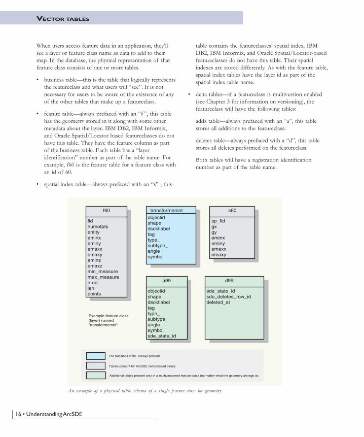
An example of a physical table schema of a single feature class for geometry
transformersnt
objectidshapedscktlabeltagtype_subtype_anglesymbol
f60
fidnumofptsentityeminxeminyemaxxemaxyeminzemaxzmin_measuremax_measurearealenpoints
s60
sp_fidgxgyeminxeminyemaxxemaxy
a99
objectidshapedscktlabeltagtype_subtype_anglesymbolsde_state_id
d99
sde_state_idsde_deletes_row_iddeleted_at
Tables present for ArcSDE compressed binary.
Additional tables present only in a multiversioned feature class (no matter what the geometry storage is).
The business table. Always present.
Example feature class (layer) named "transformersnt"
When users access feature data in an application, they�llsee a layer or feature class name as data to add to theirmap. In the database, the physical representation of thatfeature class consists of one or more tables.
� business table�this is the table that logically representsthe featureclass and what users will �see�. It is notnecessary for users to be aware of the existence of anyof the other tables that make up a featureclass.
� feature table�always prefaced with an �f �, this tablehas the geometry stored in it along with some othermetadata about the layer. IBM DB2, IBM Informix,and Oracle Spatial/Locator based featureclasses do nothave this table. They have the feature column as partof the business table. Each table has a �layeridentification� number as part of the table name. Forexample, f60 is the feature table for a feature class withan id of 60.
� spatial index table�always prefaced with an �s� , this
table contains the featureclasses� spatial index. IBMDB2, IBM Informix, and Oracle Spatial/Locator-basedfeatureclasses do not have this table. Their spatialindexes are stored differently. As with the feature table,spatial index tables have the layer id as part of thespatial index table name.
� delta tables�if a featureclass is multiversion enabled(see Chapter 3 for information on versioning), thefeatureclass will have the following tables:
adds table�always prefaced with an �a�, this tablestores all additions to the featureclass.
deletes table�always prefaced with a �d�, this tablestores all deletes performed on the featureclass.
Both tables will have a registration identificationnumber as part of the table name.

Data storage • 17
RASTER TABLES
Raster data represents a significant portion of the totaldata used in a GIS. ArcSDE provides support for rasters ina number of different formats.
ArcSDE handles raster data much like vector data. Whena business table is created with a column of raster type,ArcSDE will reference this raster column as a rasterdataset. Raster catalogs can have multiple rasters.Information about the raster column is maintained in oneof the ArcSDE system tables called raster_columns.
Here�s a brief description of the tables in raster layerschema.
For each raster type column in a business table, ArcSDEwill automatically create four additional tables. They are:
� Metadata table for raster (SDE_RAS_<id#>)
� Metadata table for raster band (SDE_BND_<id#>)
� Auxiliary table for raster band (SDE_AUX_<id#>)
� Block table (SDE_BLK_<id#>)
The first two metadata tables are used to storeinformation about a raster and a raster band such as theraster dimensions and the pixel depth.
The auxiliary table is used to save additional informationabout a raster band, such as a colormap and rasterstatistics. The block table is where the actual pixel blocksare stored.
city_photo
nameimage
SDE_aux_6
rasterband_idtypeobject
SDE_bnd_6
rasterband_idsequence_nbrraster_idnameband_flagsband_widthband_heightbahd_typesblock_widthblock_heightblock_origin_xblock_origin_y
SDE_ras_6
raster_idraster_flagsdescription
SDE_blk_6
rasterband_idrrd_factorrow_nbrcol_nbrblock_data
The 6 at the end of a table name is the internal registration ID number.
Tables that define an ArcSDE raster feature class. In this example, city_photo is the feature class users would see toadd to their map. Users do not need to be aware of the existence of the other tables.


19
33333 The The The The The ArArArArArcGIScGIScGIScGIScGISgeodatabasegeodatabasegeodatabasegeodatabasegeodatabase
The previous chapter provided the basics ofhow ArcSDE stores data in a DBMS as simplefeatures. The purpose of this chapter is tointroduce the ArcGIS geodatabase. TheArcSDE simple features provide thefoundation for the ArcGIS geodatabase. In thischapter:
• The ArcGIS database
• What is the ArcGIS geodatabase?
• Geodatabase architecture
• Geodatabase application logic
• Vector and raster data
• Geodatabase storage
• Versioned geodatabases

20 • Understanding ArcSDE
THE ARCGIS GEODATABASE
ArcGIS supports GIS data in files and DBMSs
A key cornerstone of ArcGIS is the ability to access GISdata in any format and to use multiple databases and filebases concurrently.
ArcGIS has a high-level generic geographic data model forrepresenting spatial information as features, rasters, andother spatial data types. ArcGIS supports animplementation of the data model for both file systemsand relational database management systems. The supportfor spatial data in a DBMS is via ArcSDE.
Support for file-based models includes access to numerousGIS datasets, such as coverages, shapefiles, grids, images,and triangulated irregular networks. The geodatabasemodel manages the same types of geographic informationin a relational database.
Both the file-based datasets and the DBMS-based datasetsdefine a generic model for geographic information. Thisgeneric model can be used to define and work with a widevariety of GIS applications. By defining and implementingthe behavior of a generic geographic data model,geographic information in ArcGIS can be multipurpose,shareable, and standards based. Most important, acomprehensive series of tools is available to work withthe generic data types. Thus, ArcGIS provides a robustplatform for virtually any GIS application.
Some of the common GIS data formats that can be used directly in ArcGIS.Access to and from numerous additional formats is supported through dataconversion and interoperability extensions.

The ArcGIS geodatabase • 21
WHAT IS THE GEODATABASE?
The geodatabase is a data model for representinggeographic information using standard relational databasetechnology. The geodatabase�short for geographicdatabase�supports the storage and management ofgeographic information in standard relational databasemanagement system tables via ArcSDE.
Geodatabases can scale from smaller, single-user databasesbuilt on the Microsoft Jet Engine database up to largerwork group, department, and enterprise databases accessedby many users. Two types of geodatabase architectures areavailable: personal geodatabases and multiusergeodatabases.
Personal geodatabases, which are freely available to allArcGIS users, use the Microsoft Jet Engine database filestructure to persist GIS data in smaller databases. Personalgeodatabases are much like file-based workspaces and holddatabases up to 2 GB in size. Microsoft Access is used towork with attribute tables in personal geodatabases.
Personal geodatabases are ideal for working with smallerdatasets for GIS projects and in small work groups orprojects of short duration. Typically, users will employmultiple personal geodatabases for their data collectionsand access these simultaneously for their GIS work.Personal geodatabases support single-user editing. Noconcurrent multiuser editing support is provided.
Multiuser geodatabases are primarily used in a wide rangeof work groups, departments, and enterprise settings.They take full advantage of their underlying DBMSarchitectures to support:
� Extremely large, continuous GIS databases
� Many simultaneous users
� Long transactions and versioned work flows that arecritical in GIS.
GIS database sizes and the numbers of supported userscan be much larger than GIS file bases.
Geodatabasetype
Personal geodatabase
Microsoft Jet Engine (Access)
DBMS Notes
· Single-user editing· 2 GB size limit· No versioning support
Multiuser, versioned geodatabase
· Oracle· Oracle with Spatial or Locator· IBM DB2· IBM Informix· Microsoft SQL Server
· Requires ArcSDE Gateway· Multiuser editing· Version-based workflows· Database size and number of users up to RDBMS limits
Summary of personal and multiuser geodatabases

22 • Understanding ArcSDE
GEODATABASE ARCHITECTURE
Responsibility for management of geographic datasets isshared between GIS software and generic relationaldatabase management system (DBMS) software. Certainaspects of geographic dataset management, such as disk-based storage, definition of attribute types, associativequery processing, and multiuser transaction processing,have been delegated to the DBMS. The GIS applicationretains responsibility for defining the specific DBMSschema used to represent various geographic datasets andfor domain-specific logic, which maintains the integrityand utility of the underlying records.
In effect, the DBMS is used as one of a series ofimplementation mechanisms for persisting geographicdatasets. However, the DBMS does not fully define thesemantics of the geographic data. This could be considereda multitier architecture (application and storage), whereaspects related to data storage and retrieval areimplemented in the storage (DBMS) tier as simple tables,while high-level data integrity and information processingfunctions are retained in the application and domainsoftware (GIS).
The geodatabase is implemented using the same multitierapplication architecture that you find in other advancedDBMS applications. The geodatabase objects are persistedas rows in DBMS tables that have identity, and thebehavior is supplied through the geodatabase applicationlogic.
The geodatabase architecture is based on simple relational storage andcomprehensive application logic.
At the core of the geodatabase is a standard relationaldatabase schema (a series of standard DBMS tables,column types, indexes, etc.). This simple physical storageworks in concert with and is controlled by a set of higher-level application objects hosted in the application tier(which can be an ArcGIS client or an ArcGIS Server).These geodatabase objects define a generic GISinformation model, which is shared by all ArcGISapplications and users. The purpose of the geodatabaseobjects is to expose a high-level GIS information model toclients and to persist the detailed implementation of thismodel in any appropriate storage model.
All ArcGIS applications interact with this generic GISobject model for geodatabases, not directly with the actualSQL-based DBMS instance. The geodatabase softwarecomponents implement behavior and integrity rulesimplicit in the generic model and translate data requests tothe appropriate physical database design.
Data
Rules & behavior
Geodatabase
File-baseddata XML
DBMS's
Geodatabase
The separation of geodatabase logic from storage enables support for numerousfile types, DBMSs, and XML.

The ArcGIS geodatabase • 23
ACCESSING AND USING GEODATABASE APPLICATION LOGIC
Chapter 2 , �Data storage�, had a section that reviewedrelational access and object-relational access. Thediscussion was about geodatabase metadata stored intables in the database and how ArcGIS applications usedand managed that data while non-ArcGIS applicationswere not able to use that data. Another way to look atthat topic is to discuss application logic. One view of theGeodatabase is that it is a series of software componentsthat provide complete logic for implementing, compiling,and managing GIS information objects. These geodatabasesoftware objects are accessible through a number ofArcGIS technologies:
� Interactive application interfaces in ArcGIS Desktop
� Enterprise and Web services in ArcGIS Server
� Embeddable developer components for C++, Java,COM, and .NET developers in ArcGIS Engine
All ArcGIS applications interact with this generic GISobject model (called the geodatabase), not directly withthe underlying SQL-based DBMS instances. Thegeodatabase software components implement behaviorand integrity rules implicit in the generic model andtranslate data requests to the appropriate physical databaseschema (most typically, an DBMS).
This separation of the geodatabase information modelfrom a particular DBMS schema allows support formultiple storage models for the geodatabase includingsupport for multiple DBMSs as well as support forpersonal geodatabases with Microsoft Access.

24 • Understanding ArcSDE
VECTOR DATA
Vector features (geographic objects with vector geometry)are a versatile and frequently used geographic datarepresentation, well suited for representing features withdiscrete boundaries, such as wells, streets, rivers, states,and parcels. A feature is simply an object that has alocation stored as one of its properties (or fields) in therow.
Typically, features are spatially represented as points, lines,polygons, or annotation and are organized into featureclasses. Feature classes are collections of features of thesame type with a common spatial representation and setof attributes (for example, a Line feature class for Roads).
Points Lines Polygons Annotation 3D MultiPatch
Point
Multi-points
Single part
Multi-part
Single part
Multi-part
Points withZ value
Point
Coordinates
Points withM values
01.2
2.23
(x,y)
(x,y,z)
(x,y,m)
Line
Segments
Circular arc
Elliptical arc
Bézier curve
Common vector feature representations Feature geomtry

The ArcGIS geodatabase • 25
RASTER DATA
Rasters are used to represent continuous layers, such aselevation, slope and aspect, vegetation, temperature,rainfall, and plume dispersion. Rasters are most commonlyused for aerial photographs and imagery of various kinds.
GrassShrub
Forest
Water
Beach
In addition to vector features and raster datasets, all otherspatial data types can be managed and stored in therelational tables as well, allowing you the opportunity tomanage all geographic data in a DBMS.
Geodatabases are used to manage and store diverse collections of geographicinformation types.
Imagery
Surveys
Addresses
Topology
Terrain
Networks
H
Rules & behavior

26 • Understanding ArcSDE
GEODATABASE STORAGE IN RELATIONAL DATABASES
Geodatabase storage includes the schema and rule base foreach geographic dataset as well as the spatial and attributedata. All of the data is stored in the DBMS in tables.
The Geodatabase Schema includes the definitions,integrity rules, and behavior for each geographic dataset.These include properties for feature classes, topologies,networks, raster catalogs, relationships, domains, and soforth. The schema is persisted in a collection ofgeodatabase meta-tables in the DBMS that define theintegrity and behavior of the geographic information.
The spatial representations are most commonly stored aseither vector features or as raster datasets along withtraditional tabular attributes. For example, a DBMS tablecan be used to store a feature collection where each row inthe table represents a feature. A shape column in each rowis used to hold the geometry or shape of the feature. Theshape column holding the geometry is typically one of twocolumn types:
� A binary large object (BLOB) column type
� A spatial column type, if the DBMS supports it
A homogenous collection of common features, eachhaving the same spatial representation (such as a point,line, or polygon) and a common set of attribute columns isreferred to as a feature class and is managed in a singletable.
Raster and imagery data types are managed and stored inrelational tables as well. Raster data is typically muchlarger in size and requires a side table for storage. Theraster is cut into smaller pieces, called �blocks�, and storedin individual rows in the separate block table.
The column types that hold the vector and raster geometryvary from database to database. When the DBMS supportsspatial type extensions, the geodatabase can readily usethem to hold the spatial geometry. ESRI was closelyinvolved in efforts to extend SQL spatially as the primaryauthors of the SQL 3 MM Spatial and the OGC SimpleFeatures SQL specifications. ESRI has focused on supportfor these types, as well as the independent Oracle Spatialtypes, in the persistence of geodatabases using DBMSstandards.
Feature DatasetContains spatially-related feature classes together withthe topology and network objects that bind them.Feature classes in a feature dataset havespatial reference.
Feature class
Table
Relationship class
Domain
A collection of rows, each containing the same fields.Feature classes are tables with shape feilds.
A table with a shape field containing point, line, orpolygon geometries for geographic features. Each rowis a feature.
Associates objects from a feature class or table toobjects in another feature class or table. Relationshipclasses can optionally have user-defined fields.
Defines a set or range of valid values for a field.
Integrity rules that define the behavior ofgeographically-integrated features.
Topology
Contains survey measurements which are used tocalculate coordinates linked to feature geometriesin survey-aware feature classes.
Survey dataset
Rules for managing connectivity among features ina set of feature classes.
Geometric network
Raster datasetContains rasters which represent continousgeographic phenomena.
Metadata documentAn XML document that can be associated with everydataset, commonly used in ArcIMS and otherserver applications.
Geoprocessing toolsA collection of dataflow and workflow processes forperforming data managment, analysis, and modeling.
A geodatabase is a store of geographic data implemented with the relationaldatabase of your choice. All geodatabase elements are managed in standardDBMS tables using standard SQL data types. These are some of thestructural elements of a geodatabase that you will use to develop yourgeographic data model.

The ArcGIS geodatabase • 27
GIS data, like other information, must be continuallymaintained and edited. Hence, geodatabases are designedto be transactional. The geodatabase was designed from thebeginning to be edited by many users, to scale to verylarge, continuous sizes, and support a number of commonGIS application scenarios.
GIS data compilation work flows and data sharing requirea long transaction model for numerous editing and datareplication needs. A long transaction in the GIS context isone that spans multiple days or even weeks, even whenthe user disconnects from the database. In the DBMScontext, transactions are short in the sense that no DBMStransaction persists when the user disconnects from thedatabase.
In GIS, a single edit operation is typically combined with aseries of other edits to define a complete transaction. Forexample, a typical update in land records applications is aparcel split. This involves three steps: deleting the oldparcel, creating two new parcels, and updating the taxrolls with new corresponding parcel and ownerinformation. In this simple case, a single GIS updatetransaction is actually composed of three or more DBMStransactions. In addition, GIS users often need to:
� Undo or redo individual editing operations during anediting session.
� Create a historical archive of updated features (forexample, �retired� parcels and their lineages).
In a multiuser database, the GIS transactions must beorchestrated on the DBMS�s short transaction framework.ArcSDE plays a key role during these operations bymanaging the higher-level complex GIS transactions onthe short-duration DBMS transaction framework.
GIS users have many such cases in which long transactionwork flows are critical. In most cases, these are madepossible through the use of a multiuser DBMS andArcSDE for managing updates to the central GISdatabase:
� Multiple edit sessions. A single GIS database updatemay require numerous changes that span multiple editsessions occurring over a few days or weeks.
VERSIONED GEODATABASES AND DISTRIBUTED WORK FLOWS
� Multiuser editing. Multiple editors often need toconcurrently update the same spatially integratedfeatures. Each needs to work with his or her owndatabase state, viewing their own individual updatesand ignoring updates by other editors. Eventually eachuser needs to post their updates and reconcile theirupdates with the other editors as well as identify andresolve any conflicts.
� Check-out, Check-in Transactions. Often users mightwant to check out a portion of a database for aparticular area or district onto their own computer andupdate that information in a disconnected session thatmight last for days or weeks. Eventually, they want topost their updates to the main database. In other cases,users will take a portion of a large geodatabase withthem into the field for validation and update with fieldcomputers.
� History. Some users want to maintain a historicalversion of each feature that was in their GIS database,even after that version has been updated. They want tomaintain a copy of the retired and changed features ina historical archive. Users also often need to track eachindividual feature�s history (for example, parcel lineageor feature update properties in a national mappingdatabase).
� Transfer of change-only updates. Many userscollaborate on data collection and need to shareupdates (across the World Wide Web) in a well-definedXML schema for sharing change-only updates betweendatabases. These databases can have different GISarchitectures.
� Loosely coupled replication across DBMSs. Often userswant to periodically synchronize GIS data contentsamong a series of database copies (called replicas),where each site performs its own updates on its localdatabase. Periodically, the users want to transfer theupdates from each database replica to the others andsynchronize their contents. Many times the DBMSs aredifferent (for example, to replicate datasets betweenSQL Server, Oracle, and IBM DB2).

28 • Understanding ArcSDE
What is versioning?
The geodatabase mechanism for managing these and manyother critical GIS work flows is to maintain multiplestates in the geodatabase, and most importantly, to do sowhile ensuring the integrity of the GIS database. Thisability to manage and view multiple states and to workwith them is based on versioning. Versioning, as the nameimplies, explicitly records versions of individual featuresand objects as they are modified, added, and �retired�through various states. A version explicitly records eachstate of a feature or object as a row in a table along withimportant transaction information.
Versions explicitly record the object states of ageodatabase in delta tables called the �Adds� table and the�Deletes� table. Simple queries are used to view (and
work with) any desired state of the geodatabase (forexample, to view the database state for a point in time orto see a particular user�s current version with his or heredits).
This delta table schema is used to support simultaneousediting of datasets as well as numerous version-based GISwork flows such as the examples described earlier formultiple edit sessions, history, and cross-DBMSreplication.
ArcSDE plays a critical role in versioned geodatabaseapplications and is used to manage long transactions ineach DBMS as well as across different systems.
The goal of versioning is to support these and many othercritical GIS data work flows to enable enterprise GISimplementations.
Default version
State 1 version
ID Shape Area Coverage R-ID
1 15 vegi. 10
2 30 Indust. 20
3 14 resident 30
4 12 water 40
5 25 grove 50
Base table
ID Shape Area Coverage R-ID
2 30 Indust. 20
Delete table
ID Shape Area Coverage R-ID
6 17 Indust. 60
7 13 vegi. 70
Add table

29
4 The ArcSDEarchitecture
ArcSDE provides a means to deliver datafrom a DBMS to GIS applications. It has aparticular architecture with configurationoptions that are important for databaseadministrators and application developers toknow.
In this chapter:
• What is an application server?
• Direct connections
• Connecting with a direct connect driver
• Licensing and authorization

30 • Understanding ArcSDE
Architecturally speaking, there are two basicconfigurations you can use with ArcSDE implementations.You may choose a three-tier architecture, which uses anapplication server, or a two-tier architecture, which useswhat are called direct connect drivers. You can also use acombination of the two.
The application server
ArcSDE is built with client/server architecture�a clientapplication sends requests to the server. In turn, the serverreceives the request, generates results, and delivers them tothe client.
The ArcSDE server accesses spatial data based on highlyefficient spatial search functions, provides geometric datavalidation, and works within heterogeneous hardware andnetwork environments. Data can be delivered to any clientfrom any server anywhere on a network.
In a typical configuration, an ArcSDE application serverresides with your relational database on a server platform.The ArcSDE application server performs spatial searchesand sends data that meets the search criteria to the client.For example, a common query handled by the ArcSDEapplication server is to retrieve all the features in aparticular map extent to be drawn in the display window.
ArcSDE sends data to the client using �data buffering�.Buffering is the process of collecting large chunks of dataand sending them all to the client application, rather thansending one record at a time. Processing and buffering dataon the server is much more efficient than sending all thedata across the network and having the client determinewhich data to send to the end user application. Thisbecomes critical when applications are simultaneouslyusing thousands of records in the database.
ArcSDE uses cooperative processing, which means thatdata processing occurs on both the client applicationmachine and the server, depending on which is faster.Some functions require no communication with theserver. CPU-intensive tasks, such as polygon overlay and
WHAT IS AN APPLICATION SERVER?
clipping, are best performed by the client application toavoid excessive demands on both the server and theavailable bandwidth.
The computer network connects many clients to theserver. The network must support TCP/IP. It can be alow-speed wide area network (WAN) or a fast local areanetwork (LAN). Network file system mounts are notrequired for data transfer between the server and theclient. This is an important performance andadministrative benefit.
The ArcSDE server handles simultaneous requests from multipleusers to update and retrieve information in a geodatabase.
Request
RDBMS
Clientapplication
Results
DBMS
ArcSDEapplication
server

The ArcSDE architecture • 31
The application service connection process
Geodatabase security is managed via the DBMS.Therefore, accessing data requires a �connection� to thehost DBMS. A user must enter connection informationincluding a username and password. This connectioninformation, passed on to the ArcSDE server, is used tolog in to the DBMS. If the login connection is successful,the user can then begin working with the geodatabase.
The graphic below illustrates the basic connection process.The giomgr process is the �service� to which a userconnects. Creating and managing services are described inManaging ArcSDE Application Servers. Typically, theArcSDE service runs on the same machine as the DBMSserver. The gsrvr process always runs on the same machineas the giomgr process. Each connection request starts agsrvr process. Each gsrvr process will use a DBMSconnection.
The connection wizard in ArcGIS Desktop shows a user named�map� connecting to a service named �5500� (used port # insteadof actual name in this case) on a server machine named �iceman�.In this case, the user is connecting to a DB2 database named�sdedb2�.
The illustration below shows the basics of the connection process.Typically, the giomgr process and the DBMS are on the same servermachine. The gsrvr process is always on the same machine as thegiomgr process.

32 • Understanding ArcSDE
DIRECT CONNECTIONS
ArcSDE can also be used without the application server,providing you a two-tier configuration option. The two-and three-tier systems are designed to work independentlyor together, giving the DBA flexibility in system design.When using the two-tier direct connection architecture,you will use direct connect drivers.
When using the two-tier architecture, an applicationconnects directly to the database, without using theArcSDE application server. The ArcSDE client and serverfunctionality is executed on the same machine as the clientapplication�there is no separate ArcSDE server processrunning anywhere.
The two-tier architecture provides some flexibility inconfiguring systems:
� The direct connect database driver doesn�t require theadministration of the ArcSDE server process. There isno intermediate giomgr process to set up, configure, orstart up. Setting up a single-user database usingMicrosoft Database Engine (MSDE), for example, iseasier.
� The direct connect database driver provides additionaloptions for scaling a system. The direct connectarchitecture moves the ArcSDE server functionality tothe desktop. This removes the ArcSDE load from thedatabase server and will allow additional resources tobe freed up for the DBMS, which means you get betterscalability on the database server.
� The direct connection configuration can be very usefulin �hot-failover� environments. For example, it�s easierto configure your system with Oracle RAC using thedirect connect driver.
Are there any reasons why you wouldn’t want to usethe two-tier direct connect architecture?
The following reasons might apply:
� Increased network traffic. This can happen if thespatial filter selectivity is low�for example, finding avery small number of features adjacent to a longsinuous feature that crosses a large area. Increasednetwork traffic can result in poorer overallperformance, but the severity of the degradationdepends on the bandwidth of your network.
� You do not want the administrative overhead ofnetworking software (for example, Oracle Net).
� If you are building a thin client, executing the ArcSDEserver process on the client machine may not bedesirable.
� If you have a low-end desktop computer with limitedmemory and/or chip speed, you may need to use theapplication server to move that server functionality offyour client.
The application server configuration is generally faster, butyou should do some prototyping to see whichconfiguration works best for you. However, whether youconfigure your system with the application server, directconnect drivers, or a mixture of the two, the same clientfunctionality is available to any ArcSDE clientapplication. All ESRI client products are delivered withdirect connect drivers.
Configuring your database
The ArcSDE direct connect drivers are built from thesame software code that is used to build the applicationserver. The difference is the direct connect drivers arebuilt as dynamically linked libraries and execute in theprocess space of the client application, and the applicationserver is built as an executable program that runs on theserver machine. Each user connection in a three-tierconfiguration has its own application server process.
Since the direct connect drivers are built from the samesoftware code as the application servers, the samedatabase configuration must be done as when setting up adatabase to use with the application server. The sameArcSDE user and ArcSDE and geodatabase metatablesused by the application server configuration must alsoexist for direct connection configurations. Youradministrator must set these up prior to any ArcSDEconnection requests. Your client machines must beconfigured for network access. Please read the ArcSDEinstallation guide closely for setup information as well assupported databases and hardware operating systems. Youwill also want to read the PDF file�making_a_direct_connection.pdf � on the ESRI LibraryCD�ROM. Also refer to DBMS documentation for morespecifics on client hardware configuration.

The ArcSDE architecture • 33
CONNECTING WITH A DIRECT CONNECT DRIVER
Below is a graphic illustrating the two-tier architecture. The gsrvr functionality is on the client in the form of a dynamically linked library. Theconnection is still via a DBMS account, and DBMS or operating system security is still used. Once connected, the client works directly withthe DBMS without an intermediate application server process.
34 • Understanding ArcSDE
LICENSING AND AUTHORIZATION
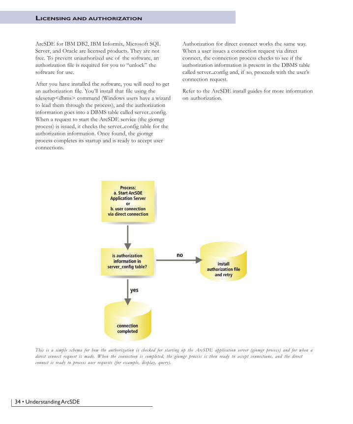
ArcSDE for IBM DB2, IBM Informix, Microsoft SQLServer, and Oracle are licensed products. They are notfree. To prevent unauthorized use of the software, anauthorization file is required for you to �unlock� thesoftware for use.
After you have installed the software, you will need to getan authorization file. You�ll install that file using thesdesetup<dbms> command (Windows users have a wizardto lead them through the process), and the authorizationinformation goes into a DBMS table called server_config.When a request to start the ArcSDE service (the giomgrprocess) is issued, it checks the server_config table for theauthorization information. Once found, the giomgrprocess completes its startup and is ready to accept userconnections.
Authorization for direct connect works the same way.When a user issues a connection request via directconnect, the connection process checks to see if theauthorization information is present in the DBMS tablecalled server_config and, if so, proceeds with the user�sconnection request.
Refer to the ArcSDE install guides for more informationon authorization.
This is a simple schema for how the authorization is checked for starting up the ArcSDE application server (giomgr process) and for when adirect connect request is made. When the connection is completed, the giomgr process is then ready to accept connections, and the directconnect is ready to process user requests (for example, display, query).

35
5 ArcSDE forCoverages
All discussion of ArcSDE up to this point hasbeen about data in a DBMS. What if you donot have a DBMS? Does this mean youcannot use ArcSDE technology? This chapterintroduces you to ArcSDE for Coverages andhow it can be used to serve coverages,shapefiles, ArcInfo Librarian™ layers, andArcStorm™ layers to your client applications.

36 • Understanding ArcSDE
While ArcSDE provides the gateway to numerouscommercial relational DBMSs, another available ArcSDEapplication server serves file-based spatial datasets. Thisread-only server, called ArcSDE for Coverages, serves thefollowing file-based vector datasets:
� ArcInfo coverages
� ESRI shapefiles
� ArcInfo Librarian layers
� ArcStorm layers
Many sites have file-based data on UNIX file servers anduse Windows client applications. Mounting disks on eachWindows machine is administrative overhead, andperformance may be poor. ArcSDE for Coverages allowsaccess of the file-based data without requiring networkfile system (NFS) disk mounts, and it can be significantlyfaster than NFS access.
ArcSDE for Coverages is crucial to providing access tofile-based spatial datasets for some ArcSDE clientapplications. ArcGIS Desktop applications, as well asArcGIS Server, MapObjects, and ArcIMS, can only accessArcInfo Librarian and ArcStorm data via ArcSDE forCoverages. In addition, ArcIMS depends on ArcSDE forCoverages to provide access to ArcInfo coverage data.
ArcSDE for Coverages can also be part of your migrationstrategy from file-based data sources to geodatabases. Themost direct way to put ArcInfo Librarian and ArcStormlayers into feature datasets of the geodatabase is by usingthe ArcSDE for Coverages server. An ArcSDE forCoverages layer can be directly loaded into a geodatabaseusing ArcCatalog�. Alternatively, you can use theArcSDE command cov2sde to put ArcInfo Librarian orArcStorm data into standalone feature classes in thegeodatabase. However, further work is required to migratethese standalone feature classes into a feature dataset.Manually creating an intermediate coverage from anArcInfo Librarian or ArcStorm layer and loading thatcoverage into the geodatabase may take considerable timeand disk space.
Customized applications built for ArcSDE for Coveragescan still be used if you migrate your data to a DBMSversion of ArcSDE, although attribute queries will needto be rewritten in SQL for your DBMS.
How does ArcSDE for Coverages work?
Your data is not copied, loaded, or otherwise movedanywhere. When your ArcSDE for Coverages server isrunning, there is a utility provided to �register� data withthe ArcSDE server. Essentially, you tell the server wherethe data is, provide a layer name, and set a few properties.At that point, the data can be served to a clientapplication. You can also set up relates to attribute data ina DBMS.
In the case of data split by tiles (ArcInfo Librarian andArcStorm line and polygon data), the data is �sewntogether� on the server if there is a unique ID for eachfeature. Once a whole feature is assembled, it is sent to theclient.
Data transfer is the same as with the DBMS version ofArcSDE. Data is delivered to clients via TCP/IP. Thismeans you need to define a service with a specific nameand TCP/IP port number in your services file.
ArcSDE for Coverages is free, and you do not need anauthorization file to unlock the software. This makes it aninexpensive way to begin working with ArcSDEtechnology.
For more information about setting up an ArcSDE forCoverages server, refer to the book ArcSDE for CoveragesAdministration Guide, now in PDF format(arcsde_cov_admin_guide.pdf), located in thedocumentation folder of the ArcSDE for Coverages CD.
The ArcSDE for Coverages CD�ROM is not in your mediakit. If you are new to ArcSDE, you will need to orderyour CD�ROM through your ESRI regional office orinternational distributor.
INTRODUCING ARCSDE FOR COVERAGES
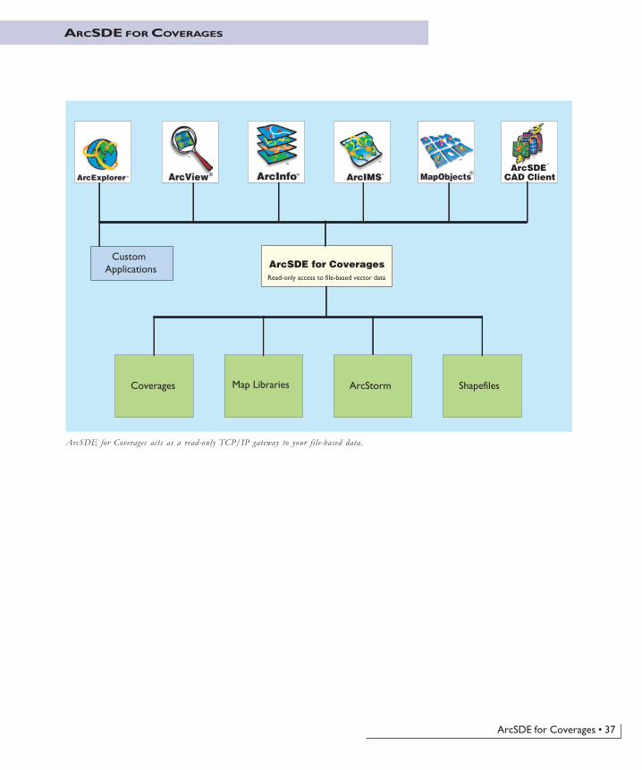
ArcSDE for Coverages • 37
ARCSDE FOR COVERAGES
CAD Client
ArcSDE for Coverages Custom Applications
Coverages Map Libraries ArcStorm Shapefiles
Read-only access to file-based vector data
®®ArcSDE
™
ArcSDE for Coverages acts as a read-only TCP/IP gateway to your file-based data.


39
6 Where to gonext
Now that you’ve read about ArcSDE, what’syour next step? Many different kinds ofpeople use ArcSDE. This chapter discusses thevarious types of work you can do with ArcSDEand what documents you should consult formore information. Four types of peopleinteract with ArcSDE, each with a differentrole: database administrators, GISadministrators, application developers, and endusers.
In this chapter:
• Administrators
• Developers
• End users
• ArcSDE resources
40 • Understanding ArcSDE
ADMINISTRATORS
To implement a multiuser GIS, two key roles must befilled: the database administrator and the GISadministrator. Sometimes these are the same person;sometimes multiple people are involved.
The database administrator
The database administrator is responsible for managing thedata being served by ArcSDE. When using the ArcSDEapplication server, the DBA also manages that server andits interface to an organization�s relational database. Thegoal of Managing ArcSDE Application Servers, along withthe ArcSDE Installation Guide (Install_<your_dbms>.htm)and ArcSDE Configuration and Tuning Guide for <yourDBMS> (ArcSDE_Config_GD_<your dbms>.pdf), is tohelp database administrators perform a number of keytasks and procedures including:
� Installing the ArcSDE application server� Configuring the ArcSDE application server for thenetwork� Starting, stopping, and monitoring ArcSDE serverprocesses� Tuning the relational database and optimizing ArcSDEperformance on the network� Setting up ArcSDE connections and user access to thedatabase
The ArcSDE application server is often installed on largemultiuser computer networks. Managing an ArcGISsystem installation is another task for databaseadministrators and requires a good understanding of thekey parts of the system. The DBMS and data are locatedon a UNIX®, Linux, or Microsoft Windows server. TheArcSDE application server is typically on the same servermachine as your DBMS, while the ESRI clientapplications are distributed on many machines across yournetwork. All parts of the ArcGIS software system usesome form of software authorization to �unlock� thevarious applications for use. To effectively manage thissystem, you should refer to the ArcGIS Desktop InstallGuide, the ArcGIS Server Install Guide, the ArcInfoWorkstation Install Guide, and a digital book namedlmrefguide.htm on the ESRI Software DocumentationCD�ROM.
The GIS administrator
The GIS administrator is responsible for designing andimplementing an organization�s geodatabase. The GISadministrator models a spatial system of features, surfaces,
images, and other geographic information to design ageodatabase that supports the work of the organization.This is a key role for a successful multiuser GIS.
It�s important to understand the spatial system to bemodeled�what its objects are and the relationshipsbetween the various objects. For example, designing ageodatabase for land records requires an understanding ofthe relationships between parcels, surveys, ownership, andimportant administrative units such as zoning andeasements. It also requires a complete understanding ofgeodatabase concepts and the best practices and methodsfor GIS database design.
The GIS administrator must be knowledgeable aboutgeodatabase structures and how to use them to represent areal-world system. The GIS administrator must alsounderstand how to apply computer tools, such as UMLmodels and the ArcGIS system, to effectively implement ageodatabase design.
A number of key books are included in the ArcGISpackage to help you accomplish these tasks:
� Modeling Our World�The ESRI Guide to GeodatabaseDesign introduces you to geodatabases and theircontents. It can help you make decisions about the beststrategies to employ in your geodatabase design. Itdescribes in detail the objects and various parts of ageodatabase. Modeling Our World will help you with thedesign process and the key decisions you�ll need tomake along the way.
� Building a Geodatabase is the GIS administrator�s guideto implementing a specific geodatabase design. Onceyou have completed your physical database design, thisbook contains all the necessary guidance to implementyour geodatabase schema. It provides information onusing ArcCatalog for these tasks and for using UML.UML is an excellent tool for object modeling anddesign. It is useful in implementing an integrated designfor an entire business database including thegeodatabase components.
If you haven�t done so already, you might also want toread Getting Started With ArcGIS. It gets you started usingthe software immediately and refers to further ArcGISdocumentation. Getting Started With ArcGIS contains anoverview of the ArcGIS software system and has a seriesof exercises that leads you through a small GIS project.

Where to go next • 41
Application developers have a number of opportunities towork with geodatabases. In the ArcGIS system, you canbuild custom applications or simply adjust the look andfeel of existing applications with Visual Basic® forApplications (VBA) within the ArcMap� and ArcCatalogapplications. ArcInfo and ArcView also ship withArcObjects�the complete set of COM-based componentsfor ArcInfo and ArcView software. The ArcInfo supersetof COM objects contains hundreds of COM classes withthousands of methods. Developers should look for moreinformation in one of the following:
• ArcGIS Desktop Developer Guide
• ArcGIS Server Developer Guide
• ArcGIS Engine Developer Guide
available on the ESRI Software Documentation LibraryCD�ROM. ArcGIS Server also comes with a .NET ADFand a Java ADF.
Other ESRI software, such as ArcIMS, ArcView GIS 3,and MapObjects 2, can use the ArcSDE application serverdirectly. In these systems, you can create customapplications that access spatial data through ArcSDE.Each software program provides its own ArcSDEprogrammer�s interface that you can take advantage of as adeveloper.
ArcIMS
ArcIMS allows direct customization at all levels. At theclient level, custom HTML and JavaScript� can be usedto modify the look and feel of the viewer. At the serverlevel, ArcXML can be used to modify map configurationfiles�to project data, change the appearance of mapfeatures, and so on. It is also possible to incorporatecustom and advanced services and tools.
ArcIMS supports a number of Internet developer toolsincluding Active Server Pages (ASP) for Microsoftdevelopers, and JavaServer Pages� (JSP�) to build Webapplications using Java 2 Platform, Enterprise Edition(J2EE�), and ColdFusion®. See the ArcIMSdocumentation set for more information.
ArcView GIS 3
The ArcView GIS 3 object-oriented programminglanguage, Avenue�, can access ArcSDE functionality inaddition to customizing the look of ArcView GIS 3. Thesubsystem that accesses and works with the ArcSDE
DEVELOPERS
application server is the Database Access extension. Referto the book Using Avenue in the ArcView GIS package foradditional guidance.
MapObjects Windows Edition
You can also develop applications with MapObjectsWindows edition using Visual Basic, Visual C++®, andother COM-based developer tools. A part of theMapObjects 2 developer components describes buildingapplications that access and work with ArcSDE. TwoMapObjects user guides have more information onbuilding MapObjects applications that use the ArcSDEapplication server: Developing Applications with MapObjectsand MapObjects Programmer�s Reference, both found in theMapObjects package.
ArcSDE CAD Client
With the ArcSDE CAD Client extension, you can workwith true CAD entities in a geodatabase. The ArcSDECAD Client extension has an extensive C language APIthat has complete access to all ArcSDE functionality. Formore information, see Using ArcSDE CAD Client,included as a PDF file (usingcadclient.pdf) in thedocumentation folder on the ArcSDE Developer Kit CD�ROM.
The ArcSDE application server provides an open clientinterface to work with the contents of geodatabases assimple features. The ArcSDE simple feature API allowsnon-ESRI software applications to access and work withgeodatabases. The ArcSDE client API is available in bothC and Java. Refer to ArcSDE Developer Help, located in thedocumentation_sdk folder on the ArcSDE Developer KitCD�ROM.

42 • Understanding ArcSDE
END USERS
Typically, end users are those using a client application,such as ArcMap, which may be highly customized. Mostend users do not know or even need to know they�re usingArcSDE to access data in a DBMS. Working with amultiuser geodatabase is just like working with any othergeographic data�use ArcCatalog to explore and workwith data holdings; use ArcMap to map, edit, and analyzedata from the geodatabase; and use ArcIMS to publishyour maps on the Internet.
If you haven�t done so already, you might want to readWhat is ArcGIS? and Getting Started With ArcGIS. What isArcGIS? is a high-level overview of what ArcGISsoftware is all about. The Getting Started With ArcGISbook gets you started using the software immediately andrefers to further ArcGIS documentation. It also containsan overview of the ArcGIS software system and has aseries of exercises that leads you through a small GISproject. Other ESRI software programs also have booksgeared for end users.

Where to go next • 43
ARCSDE RESOURCES
This book is designed to provide an introduction toArcSDE and a brief explanation of its roles and benefits.For more detailed information about ArcSDE, you areencouraged to explore the additional resources available.These are listed and described below.
ArcSDE
ArcSDE Installation Guide: An HTML file that containsdetailed installation instructions. The file is calledInstall_<your dbms>.htm and is located in the rootdirectory of the platform-specific ArcSDE CD�ROM.
Managing ArcSDE Application Servers: Available as a printedbook and as a PDF file on the ESRI SoftwareDocumentation Library CD�ROM.
ArcSDE Configuration and Tuning Guide for <your DBMS>:This is one of the DBMS-specific PDF files(ArcSDE_Config_GD_<your dbms>.pdf) in thedocumentation_server folder on the ArcSDE CD�ROM.
ArcSDE Developer Help: Contains developer informationon C and Java and command references for ArcSDEadministration commands, located in thedocumentation_sdk folder on the ArcSDE Developer KitCD�ROM.
ArcSDE Administration Command References: Available as anHTML file called admincmdref.htm in thedocumentation_server/Admin_Cmd_Ref folder of eachArcSDE CD�ROM. Windows users also have access to a.chm version of the file for use with Internet Explorer.
Making a Direct Connection: Available as a PDF file on theESRI Software Documentation Library CD�ROM(Making_a_Direct_Connection.pdf). The book assumesyou�ve already read Chapter 4, �The ArcSDE architecture�,of this book. Provides practical information for setting upand configuring a system for direct connect configurationsand some examples of how to connect via various ESRIclient applications.
ArcSDE CAD Client
Using ArcSDE CAD Client: Available as a PDF file(usingcadclient.pdf) in the documentation folder on theArcSDE Developer Kit CD�ROM.


45
Glossary
annotationDescriptive text used to label features. Used for display,not for analysis.
APIApplication programming interface. Refers to adefined and documented set of tools or functions thatapplication developers use to build or customize a programor set of programs. APIs can be built for programminglanguages, such as C, COM, and Java.
application serverA computer program that receives requests from a clientapplication�another computer program that a userinteracts directly with�and returns results to the client.See also client/server and server.
ArcSDEArcSDE Server software that provides ArcSDE clientapplications (for example, ArcGIS Desktop, ArcGISServer, ArcIMS) a gateway for storing, managing, andusing spatial data in one of the following commercialdatabase management systems: IBM DB2 UDB, IBMInformix, Microsoft SQL Server, and Oracle.
ArcSDE for CoveragesAn ArcSDE server that provides read-only access toArcInfo coverages, shapefiles, ArcStorm librarylayers, and Map Librarian layers. Uses the same datatransfer technology as ArcSDE for DBMS products.
ArcStormArcStorm is a data storage facility and transaction managerfor ArcInfo file-based coverage data. ArcStorm manages afeature-oriented database that can be closely integratedwith an DBMS. Transaction management occurs viafeature locking.
attribute1. A characteristic of a geographic feature described by
numbers, characters, images, and CAD drawings,typically stored in tabular format and linked to thefeature. For example, the attributes of a well mightinclude depth and gallons per minute.
2. A column in a database table.
bandOne layer of a multispectral image or raster dataset.For example, a specific range of the electromagneticspectrum of reflected light or heat�ultraviolet, blue,green, red, near infrared, infrared, thermal, radar,and so on.
behaviorImplementation of an object class method. Thebehavior is a procedure stored within the objectthat is activated when the appropriate method iscalled on the object. The same method on twoobject classes can have different behavior.
BLOBBinary large object. The binary data type of acolumn in a DBMS table that stores large image, text, orgeometry data as attributes.
CADComputer-aided design. An automated system forthe design, drafting, and display of graphicallyoriented information.
CASEComputer-Aided Software Engineering. Consists of toolsand techniques that automate the process of developingsoftware systems or schemas. Complex tasks that oftenrequire many lines of code to be written are simplifiedwith CASE user interfaces and code generators.

46 • Understanding ArcSDE
client/serverA software system is said to have a client/serverarchitecture when there is a central process (server) thataccepts requests from multiple user processes calledclients.
columnThe vertical dimension of a table that holds attributevalues. A column has a name and a data type applied to allvalues in the column. A table has rows and columns. Seealso table and row.
COMComponent Object Model. A binary specificationfrom Microsoft Corporation that establishes acommon way of building software components.COM objects have interfaces that contain methodsand properties.
COM objectAn object that implements its methods andproperties through interfaces. COM objects haveone or more interfaces and behave as servers that interactwith clients through an interface. Client code grabs a COMobject�s interface and tells that object to perform afunction or manipulate a property. COM components canbe dynamically interchanged in a distributed system withDynamic Link Libraries (DLLs are in-process servers) andexecutable programs (EXEs are out-of-process servers).
concurrency managementA database management process for maintainingthe consistency of the data while supportingsimultaneous access by more than one user. Atypical technique is to use a system of locking datato prevent data corruption caused by multiple usersediting and reading it.
conflictIn the context of versioning and reconciling edits toa database, a conflict occurs when two userssubmit edits that are in conflict with each other.
conflict resolutionThe process of resolving conflicting edits that havebeen made in two or more versions of the same dataset. Inthe version reconciliation process, if the same feature inthe source version and destination version have both been
edited, the feature is said to be in conflict. The feature�sconflict must be reconciled by user intervention.
coordinateA set of numbers that designates location in a givenreference system such as x,y in a planar coordinate systemor x,y,z in a three-dimensional coordinate system.Coordinates represent locations on the earth�s surfacerelative to other locations.
coordinate systemA reference system used to measure horizontal andvertical distances on a planimetric map. Acoordinate system is usually defined by a mapprojection, a spheroid of reference, a datum, one ormore standard parallels, a central meridian, andpossible shifts in the x- and y-directions to locatex,y positions of point, line, and area features.
coverageA file-based vector data storage format for storingthe location, shape, and attributes of geographicfeatures. One of the primary vector data storageformats for ArcInfo.
custom featureA feature with specialized behavior in thegeodatabase created as a COM object by adeveloper.
data dictionaryA set of tables containing information about data.ArcSDE and the geodatabase have data dictionarytables containing information about the GIS data in thedatabase.
data integrityMaintenance of data values according to datamodel and data type. For example, to maintainintegrity, numeric columns will not accept characterdata.
data typeOne of the forms of data that can be stored in adatabase table. Common data types are CHAR, DATE,LONG, NUMBER, and RAW.
Glossary • 47
database1. A collection of related data organized for efficient
retrieval of information.
2. A logical collection of interrelated informationmanaged and stored as a unit, usually on some form ofmass storage system such as magnetic tape or disk. AGIS database includes data about the spatial locationand shape of geographic features recorded as points,lines, areas, pixels, grid cells, or TINs, as well as theirattributes.
database administratorOne who manages a database�sets up users,security, backup, and recovery procedures for alldata and optimizes physical data storage for bestperformance.
database connectionA connection to a DBMS server, an ArcSDE applicationserver, or an Object Linking and Embedding (OLE)database.
DB2A commercial DBMS from IBM that is supported byArcSDE.
DBMSDatabase management system. A set of computerprograms for organizing the information in adatabase. A DBMS supports the structuring of thedatabase in a standard format and provides toolsfor data input, verification, and storage. Sometimesreferred to as RDBMS.
domainA named constraint in the database. This namedconstraint can be associated with a field for thesubtype of a feature class or table to make anattribute validation rule.
feature1. A vector object in a geodatabase that has a
geometry type of point, line, polygon, orannotation. Features are stored in feature classes.
2. A representation of a real-world object in a layer on amap.
feature classIn a geodatabase, an object class that stores features andhas a field of type geometry in a geodatabase. Featureclasses can be standalone or integrated with other featureclasses in a feature dataset.
feature datasetA collection of feature classes that share the samespatial reference. Because the feature classes sharethe same spatial reference, they can participate intopological relationships with each other such as ina geometric network. Object classes andrelationship classes can also be stored in a featuredataset.
fieldPart of a table that holds one piece of data. Theintersection of a row and a column.
geodatabaseAn object-oriented geographic database that ishosted inside a DBMS. Object behavior is implementedusing validation rules, relationships, and topologicalassociations.
geographic dataThe locations and descriptions of geographicfeatures. The composite of spatial data anddescriptive data.
geographic databaseA collection of spatial data and related descriptivedata organized for efficient storage and retrieval bymany users.
geolocationThe process of creating features from tabular databy matching the tabular data to a spatial location.One example of geolocation is creating pointfeatures from a table of x,y coordinates. Points canalso be created by matching addresses to streets.
geometric networkA graph or logical network composed of connectedfeatures. For example, networks include roadsystems, utility networks, and hydrologic networks.Geometric networks contain feature classes that have

48 • Understanding ArcSDE
network roles such as simple junction features, complexjunction features, simple edge features, and complex edgefeatures. More than one feature class can have the samerole.
gridA geographic data model representing information as anarray of equally sized square cells arranged in rows andcolumns. Each grid cell is referenced by its geographic x,ylocation. See also raster and grid cell.
grid cellA discretely uniform unit that represents a portionof the earth such as a square meter or square mile.Each grid cell has a value that corresponds to thefeature or characteristic at that site such as a soil type,census tract, or vegetation class. Additional values of thecell can be stored in a value attribute table (VAT).
imageRepresents geographic features by dividing theworld into discrete squares called cells. Examplesinclude satellite and aerial photographs, scanneddocuments, and building photographs. See alsoraster.
indexA database tool put on a column or columns of atable and used to speed execution and imposeuniqueness on data. Provides faster access to datathan doing a full table scan.
InformixA commercial DBMS from IBM that is supported byArcSDE.
instanceSee service.
joinRetrieval of data from more than one table in onequery.
LANLocal area network. A computer datacommunications technology that connects
computers at the same site�for example, all computers inthe same building. Computers and terminals on a LAN canfreely share data and peripheral devices such as printersand plotters. LANs are composed of cabling and specialdata communications hardware and software.
layer1. A feature class in a geodatabase, as in an SDE layer.
2. A cartographic rendering of a feature class, image, TIN,or graphic in a map.
linear featureA geographic feature represented by a line or set oflines. A line connects two or more x,y coordinates.Rivers, roads, and electric and telecommunicationnetworks are all linear features.
long transactionAn edit session on a feature dataset that may last from afew minutes to several months. Long transactions aremanaged by the ArcSDE versioning mechanism.
map projectionA mathematical model that transforms the locationsof features on the earth�s surface to locations on atwo-dimensional surface. Because the earth is three-dimensional, a method must be used to depict a map intwo dimensions. Some projections preserve shape; otherspreserve accuracy of area, distance, or direction. See alsocoordinate system.
metadataData about data. For GIS data, metadata typicallymeans data that is designed to help a prospectiveuser find GIS data for a specific purpose.
methodAn action that an object is capable of performing.Objects that belong to the same class all have thesame methods. For example, all form objectsunderstand a method called �Show and Hide�.
Microsoft AccessA commercial DBMS used for a personal geodatabase.
Microsoft SQL ServerA commercial DBMS that is supported with ArcSDE.

Glossary • 49
MSDEMicrosoft Database Engine. A client/server data enginebased on Microsoft SQL Server. Can be used with theArcSDE for SQL Server product.
multiuser geodatabaseA geodatabase in a DBMS served to client applications(for example, ArcMap) by ArcSDE. Multiusergeodatabases can be very large and support multipleconcurrent editors. Supported on a variety of commercialDBMSs including Oracle, Microsoft SQL Server, IBMDB2, and Informix.
network traceNavigates a network following connectivity defined by thegeometric network. Specific kinds of network traces are:
� Find connected
� Find loops
� Find common ancestors
� Trace upstream
� Trace downstream
See also geometric network.
OGCOpen GIS Consortium. Go to the Web page atwww.opengis.org for more information.
OracleA commercial DBMS supported by ArcSDE.
personal geodatabaseA geodatabase, usually on the same machine as theclient application (for example, ArcMap), thatsupports one editor at a time. Personalgeodatabases are managed in a Microsoft Jet Enginedatabase.
planar topologyRepresents collections of topological feature classes thatshare geometry among their boundaries. One or morefeature classes that share geometry participate in acommon planar topology. Updating shared boundariesupdates all features in the topology.
pointA single x,y coordinate that represents a single geographicfeature such as a telephone pole.
polygonA two-dimensional feature representing an area such as astate or county.
propertyAn attribute of a control, field, or database objectthat you set to define one of the object�scharacteristics or an aspect of its behavior. Forexample, the �Visible� property affects whether acontrol can be seen at run time.
pyramidThe storage of image data in multiple resolutions to speedquery and retrieval.
queryA SQL expression to retrieve data from one or moretables.
rasterRepresents any data source that uses a gridstructure to store geographic information. See alsogrid and image.
RDBMSDatabase management system. A set of computerprograms for organizing the information in a database. ADBMS supports the structuring of the database in astandard format and provides tools for data input,verification, and storage. See also DBMS.
recordA horizontal dimension to a table. A single row ina table. See also row and column.
referential integrityThe capability to ensure that changes to one table thataffect other tables are transmitted automatically to thoseother tables. For example, a table will not be given aforeign key value that does not exist as a primary key inanother table.

50 • Understanding ArcSDE
relationshipAn association or link between two objects. See alsorelationship class.
relationship classObjects in a real-world system often have particularassociations with other objects in the database. Thesekinds of associations between objects in the geodatabaseare called relationships. Relationships can exist betweenspatial objects (features in feature classes), nonspatialobjects (rows in a table), or spatial and nonspatial objects.While spatial objects are stored in the geodatabase infeature classes, and nonspatial objects are stored in objectclasses, relationships are stored in relationship classes.
row1. A record in an attribute table. The horizontal
dimension of a table composed of a set of columnscontaining one data item each.
2. A horizontal group of cells in a grid or pixels in animage.
schema1. The structure or design of a database or database
object such as a table.
2. The definition of the database. The schema can eitherbe modeled in UML using a CASE tool or defineddirectly within ArcCatalog using wizard dialog boxes.
SDESee ArcSDE.
server1. A computer program that receives a request from a
client, processes it to generate results, and returns theresults to the client.
2. A computer on which a server process runs.
serviceA computer program that receives and processesrequests from clients.
shapeThe characteristic appearance or visible form of ageographic object. Geographic objects can be representedon a map using one of three basic shapes: points, lines, orpolygons.
shapefileA vector data storage format for storing the location,shape, and attributes of geographic features.
SQLStructured Query Language. A syntax for defining andmanipulating data from a relational database. Developedby IBM in the 1970s, it has become an industry standardfor query languages in most DBMSs.
SQL ServerSee Microsoft SQL Server.
tableInformation formatted in rows and columns. A set of dataelements that has a horizontal dimension (rows) and avertical dimension (columns) in an DBMS. A table has aspecified number of columns but can have any number ofrows. See also attribute.
TCP/IPThe Transmission Control Protocol (TCP) is acommunication protocol layered above the InternetProtocol (IP). These are low-level communicationprotocols that allow computers to send and receivedata.
topologyThe spatial relationship between features. See alsoplanar topology.
transactionA logical unit of work as defined by a user.Transactions can be data definition (create anobject), data manipulation (update an object), ordata read (select from an object).
UMLUnified Modeling Language. A standard forrepresenting object designs. See also CASE.
validation rulesApplied to objects in the geodatabase to ensure thattheir state is consistent with the system that the databaseis modeling. The geodatabase supports attribute,connectivity, relationship, and custom validation rules.

Glossary • 51
vector modelA representation of the world using points, lines, andpolygons. Vector models are useful for representing andstoring discrete features such as buildings, pipes, or parcelboundaries.
versionA version is an alternative representation of thegeodatabase that has an owner, a description, and a levelof access (private, protected, and public).
version mergingThe process of reconciling two versions of a featuredataset into a common version. If conflicting edits havebeen made in either of the merged versions, these conflictsare resolved, either automatically or by an interactiveprocess.
version reconciliationThe process of updating a version of a dataset withchanges made in another version. Using thistechnique, a version can remain up to date withchanges even if it is within a long transaction lastingmany months.
vertexOne of a set of ordered x,y coordinates that definesa line or polygon feature.
WANWide area network. A computer data communicationstechnology that connects computers at remote sites (forexample, city to city) to computers at other remote sites.WANs are composed of special data communicationshardware and software and usually operate across publicor dedicated telephone networks. Typically, data accessover a WAN is slower than over a LAN. See also LAN.
