undergraduate study programmes
TRANSCRIPT
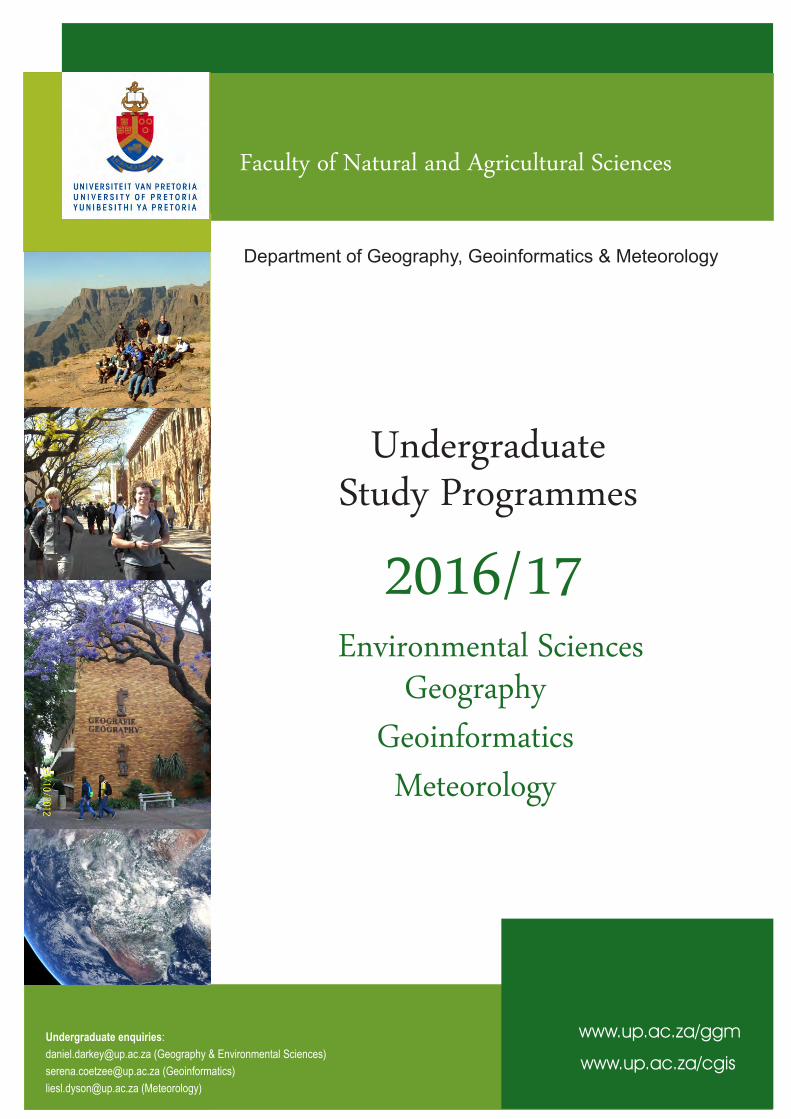
2016/17
UndergraduateStudy Programmes
Undergraduate enquiries:
[email protected] (Geography & Environmental Sciences)
[email protected] (Geoinformatics)
[email protected] (Meteorology)
www.up.ac.za/ggm
www.up.ac.za/cgis
Department of Geography, Geoinformatics & Meteorology
Environmental Sciences
Meteorology
GeographyGeoinformatics
Faculty of Natural and Agricultural Sciences


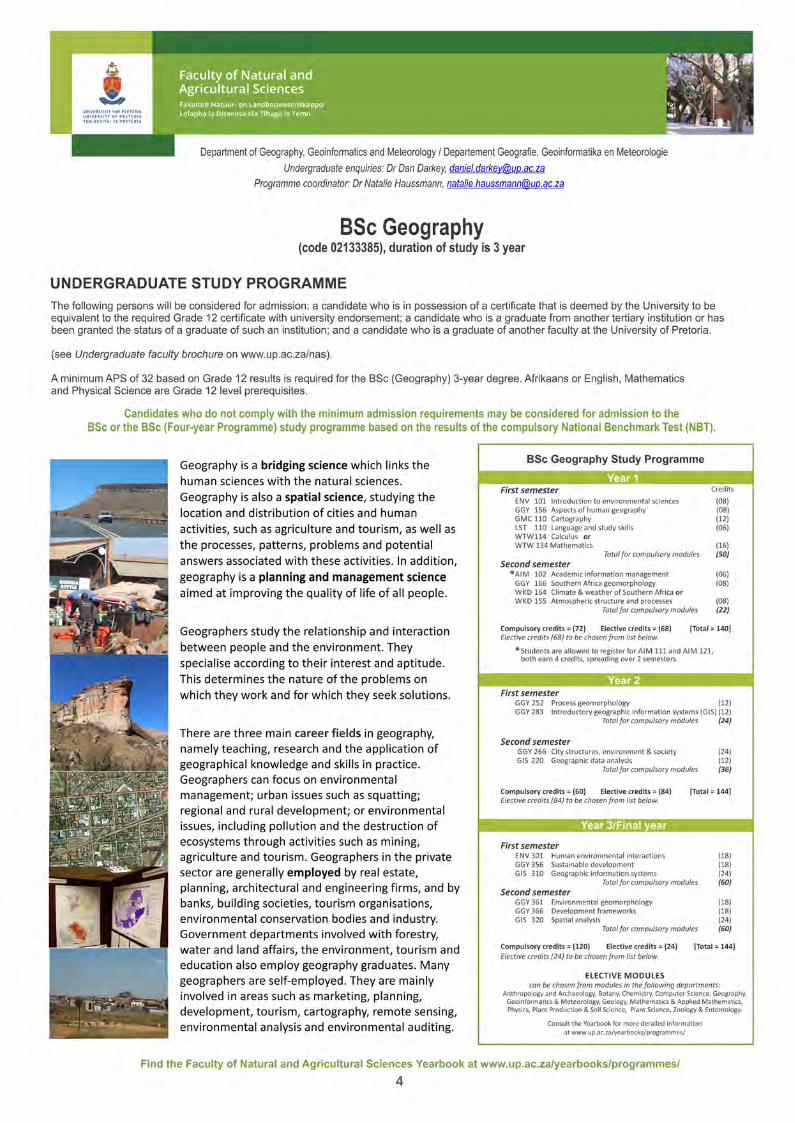
Department of Geography, Geoinformatics and Meteorology, Faculty of Natural and Agricultural Sciences, University of Pretoria
Table of Contents
· General and specific admission requirements pages 1-2
Undergraduate Programmes
· BSc in Environmental Sciences page 3
· BSc in Geography page 4
· BSc in Geoinformatics page 5
· BSc in Meteorology page 6
· BA with specialisation in Geography page 7
Undergraduate Modules pages 8-13
What can I do with my degree? (JOBS) page 14
www.up.ac.za/ggm

University of Pretoria: General and specific admission requirements
General Application Information • UP applications open on 1 March and close by
o 30 September for South African students and
o 31 August for non-South African students of the year preceding the year of study.
• Each prospective student must complete only one application form. On the application form the
University of Pretoria offers a first and second choice in terms of what you wish to study. All applicants
should fill in both a first and second choice on the application form.
• Once your application form has been processed, you will receive a student number (EMPLID).
• Receiving a student number (EMPLID) does NOT imply that you have been accepted by the University of
Pretoria yet. Admission is a separate process that your application undergoes after being evaluated by the
relevant faculty.
• It is in your best interest to complete your own application form. The University of Pretoria does not make
use of representatives, agents or agencies during the application process. If you choose to make use of
representatives, agents or agencies, you do so at your own risk. It is of utmost importance that you provide
your personal email and postal addresses to enable the University of Pretoria to communicate with you
directly.
Various ways to apply
The Online Application System is intended for use by new prospective students submitting an application to UP
for the first time. It is not intended for students presently registered at the University of Pretoria.
• To use the Online Application System you will need the following:
a. internet access
b. an email address which you can access regularly, because as soon as you submit your online
application, a student number (EMPLID) will be sent to this email address as confirmation of
receipt.
• Paper-based Application
a. Prospective students may download and complete a hard copy application form. Once you have
completed it and attached proof of payment of R300 to it (no cash please), please mail it to:
b. Student Service Centre
University of Pretoria
Private Bag X20, Hatfield, 0028
South Africa
c. You can also request that a hard copy application form be posted to you by sending an e-mail with
your details to [email protected] or by calling +27 (0)12 420 3111.
Please note: Each application form has a unique number which is printed under the barcode on page one. This
number is repeated on each subsequent uneven page number. It is therefore imperative that you do not mix
pages with different numbers or application forms. For this reason the University will only accept original
application forms. Faxed, scanned or e-mailed application forms will not be accepted.
Go to http://www.up.ac.za/en/new-students-undergraduate/article/256308/apply-at-up for more detailed information.
1

Admission Requirements
• In order to register NSC/IEB/Cambridge candidates must comply with the minimum requirements fordegree studies as well as the minimum requirements for the relevant study programme.
• Life Orientation is excluded in the calculation of the Admission Point Score (APS).• How is the APS calculated? Thence the NSC/IEB certificate as an example. APS=7 Outstanding
Achievement (80-100%), APS=6 Meritorious Achievement (70-79%), APS=5 Substantial Achievement(60-69%), APS=4 Adequate Achievement (50-59%), APS=3 Moderate Achievement (40-49%), APS=2Elementary Achievement (30-39%) and APS1=1 Not Achieved. Achievement level (APS) scores forHICSE, AS- and A-levels differ.
• Grade 11 results are used for the provisional admission of prospective students.• Final admission is based on the Grade 12 results.
Specific admission requirements for the Study Programmes in the Department of Geography, Geoinformatics and Meteorology
Programme Minimum requirements for 2017
Achievement level
APS
PHYSICAL SCIENCES Afrikaans or English Mathematics Physical Science
NSC/ IEB
HIGCSE AS-
Level A-
Level NSC/ IEB
HIGCSE AS-
Level A-
Level NSC/ IEB
HIGCSE AS-
Level A-
Level
BSc (Geography) [3 years] 5 3 C C 5 3 C C 5 3 C C 32
BSc (Geoinformatics) [3 years] 5 3 C C 5 3 C C 5 3 C C 32
BSc (Meteorology) [3 years] 5 3 C C 5 3 C C 5 3 C C 32
BSc Meteorology is the only degree of its kind offered in sub-Saharan Africa on an undergraduate and postgraduate level.
BSc (Environmental Sciences) [3 years] 5 3 C C 5 3 C C 5 3 C C 32
Candidates who do not comply with the minimum admission requirements for the Physical Sciences programmes above, may be considered for admission to the BSc – Extended programme below. A NBT (Nationalbench Mark Test
The BSc Extended programme takes place over a period of four years instead of the normal three years.
BSc – Extended programme for the Physical Sciences 4 3 D D 4 3 D D 4 3 D D 26
Students can also enrol for selected Geography, Geoinformatics and Meteorology modules when doing their degree in other faculties [i.e. Humanities (BA) and Education (BEd)]. Confirm admission requirements for the degree in the yearbooks on www.up.ac.za
2


Department of Geography, Geoinformatics and Meteorology UNDERGRADUATE MODULES _____________________________________________________________________ ENV 101 Introduction to environmental sciences 101 Academic organisation: Geogr aphy, Geoinformatics and Meteorology Prerequisite: None Contact time: 3 lpw Period of presentation: Quarter 1 Language of tuition: English Credits: 8 Module content: Introducing the basic concepts and interrelationships required to understand the complexity of natural environmental problems, physical and human environment, human induced environmental problems, the ways in which the natural environment affects human society and biodiversity, an introduction to major environmental issues in southern Africa and sustainable development in the context of environmental issues. ENV 301 Human environmental interactions 301 Academic organisation: Geography, Geoinformatics and Meteorology Prerequisite: None Contact time: 4 lpw 1 ppw Period of presentation: Quarter 2 Language of tuition: English Credits: 18 Module content: The module focuses on contemporary environmental issues in southern Africa. Recent and future impacts of human pressures on natural resources, the state of the environment in South Africa, management of critical resources, population trends, bio-diversity loss, pollution, water scarcity, desertification, climate change, waste accumulation and management, environmental management tools, environmental education and environmental management legislation.
GGY 156 Aspects of human geography 156 Academic organisation: Geography, Geoinformatics and Meteorology Prerequisite: None Contact time: 3 lpw 1 tpw Period of presentation: Quarter 2 Language of tuition: English Credits: 8 Module content: This module begins by fostering an understanding of human geography. Then follows the political ordering of space; cultural diversity as well as ethnic geography globally and locally; population geography of the world and South Africa: and four economic levels of development. The purpose is to place South Africa in a world setting and to understand the future of the country. GGY 166 Southern African geomorphology 166 Academic organisation: Geography, Geoinformatics and Meteorology Prerequisite: None Contact time: 4 lpw Period of presentation: Quarter 3 Language of tuition: English Credits: 8 Module content: Investigating southern African landscapes and placing them in a theoretical and global context. The geomorphological evolution of southern Africa. Introduction to the concepts of Geomorphology and its relationships with other physical sciences (eg meteorology, climatology, geology, hydrology and biology). The processes and controls of landform and landscape evolution. Tutorial exercises cover basic techniques of geomorphological analysis, and topical issues in Geomorphology.
GGY 252 Process geomorphology 252 Academic organisation: Geography, Geoinformatics and Meteorology Prerequisite: GGY 166 or GLY 155 Contact time: 4 lpw 2 ppw Period of presentation: Quarter 2 Language of tuition: English Credits: 12 Module content: Physical processes that influence the earth’s surface and management. Specific processes and their interaction in themes such as weathering; soil erosion; slope, mass movement and fluvial processes. Practical laboratory exercises are based on the themes covered in the module theory component. GGY 265 Geomorphology of the built environment 265 Academic organisation: Geography, Geoinformatics and Meteorology Prerequisite: None Note: This module is for Architecture and Landscape Architecture students only Contact time: 4 lpw Period of presentation: Quarter 3 Language of tuition: English Credits: 12
8

Department of Geography, Geoinformatics and Meteorology UNDERGRADUATE MODULES _____________________________________________________________________ Module content: The theory component covers geomorphological aspects of the built environment including landscape identification; weathering or deterioration of natural stone and application to design and preservation of buildings and monuments; slope hydrology and stability conditions; soil erosion processes and construction impacts; drainage modification in urban areas; wetland identification, human impacts and rehabilitation; recreational impacts and management. In addition to the theory a field-based project is undertaken. GGY 266 City structure, environment and society 266 Academic organisation: Geography, Geoinformatics and Meteorology Prerequisite: None Contact time: 3 lpw 1 ppw Period of presentation: Semester 2 Language of tuition: English Credits: 24 Module content: An urbanising world. Urban structure and land use. Urban processes. The urban environment. Social structure and change in cities. Living in the city. Economy, society and politics in the city. Third-world cities and South African cities. Urban futures. GGY 283 Introductory geographic information systems 283 (to be approved for 2017) Academic organisation: Geography, Geoinformatics and Meteorology Prerequisite: GMC 110 Contact time: 2 lpw 1 ppw Period of presentation: Semester 1 Language of tuition: English Credits: 14 Module content: Introduction to Geographic Information Systems (GIS), theoretical concepts and applications of GIS. The focus will be on the GIS process of data input, data analysis, data output and associated technologies. This module provides the foundations for more advanced GIS and Geoinformatics topics. GGY 356 Sustainable development 356 Academic organisation: Geography, Geoinformatics and Meteorology Prerequisite: None Contact time: 3 lpw 1 ppw Period of presentation: Quarter 1 Language of tuition: English Credits: 18 Module content: The module conceptually integrates environmental, economic, and social components of sustainable development. Other topics covered include changing perceptions on development and environment, development paradigms, challenges of sustainable development, actors and actions in sustainable development, rural and urban livelihoods, and a Third World assessment of sustainable development in the developing world. GGY 361 Environmental geomorphology 361 Academic organisation: Geography, Geoinformatics and Meteorology Prerequisite: GGY 252 Note: The module is for BSc (Geography), BSc (Environmental Sciences) students only. The theory content of this module is the same as GGY 363 and students are not allowed to earn credits for both GGY 361 and GGY 363. Contact time: 4 lpw 2 ppw Period of presentation: Quarter 4 Language of tuition: English Credits: 18 Module content: Interactions of geomorphic processes within the physical and built environments; themes such as geomorphology and environmental change, slope processes and the environment, geomorphic risks and hazards, soil erosion and conservation, geomorphology in environmental management, applied weathering. Practicals involve fieldwork including sampling and mapping and subsequent laboratory analysis. GGY 363 Applied geomorphology 363 Academic organisation: Geography, Geoinformatics and Meteorology Prerequisite: GGY 252 Note: The content of this module is the same as GGY 361 and students are not allowed to earn credits for both GGY 361 and GGY 363. Contact time: 4 lpw Period of presentation: Quarter 4 Language of tuition: English Credits: 12 Module content: Interactions of geomorphic processes within the physical and built environments; themes such as geomorphology and environmental change, slope processes and the environment, geomorphic risks and hazards, soil erosion and conservation, geomorphology in environmental management, applied weathering.
9

Department of Geography, Geoinformatics and Meteorology UNDERGRADUATE MODULES _____________________________________________________________________ GGY 366 Development frameworks 366 Academic organisation: Geography, Geoinformatics and Meteorology Prerequisite: None Contact time: 3 lpw 1 ppw Period of presentation: Quarter 3 Language of tuition: English Credits: 18 Module content: Classic development frameworks. Spatial development history and legacy in South Africa. Overview of contemporary environmental legislation in South Africa. Rural development strategy. Rural and agricultural reconstruction. Land reform. Urban development and strategy. Urban spatial reconstruction. National spatial development frameworks. GIS 220 Geographic data analysis 220 Academic organisation: Geography, Geoinformatics and Meteorology Prerequisites: GMC 110 (and STK110 or BME 120) Contact time: 3 lpw 1 ppw Period of presentation: Semester 2 Language of tuition: English Credits: 14 Module content: The nature of geographical data and measurement. Application of statistics in the geographical domain. Probability, probability distributions and densities, expected values and variances, Central Limit theorem. Sampling techniques. Exploratory data analysis, descriptive statistics, statistical estimation, hypothesis testing, correlation analysis and regression analysis. GIS 221 Geographic information systems introduction 221 Academic organisation: Geography, Geoinformatics and Meteorology Prerequisite: None Note: GIS 221 does not lead to admission to any module at 300 level. Contact time: 2 lpw 1 ppw Period of presentation: Semester 2 Language of tuition: English Credits: 12 Module content: Introduction to Geographic Information Systems (GIS), theoretical concepts and applications of GIS. The focus will be on the GIS process of data input, data analysis, data output and associated technologies. This module teaches students to use GIS as a tool. GIS 310 Geographic information systems 310 Academic organisation: Geography, Geoinformatics and Meteorology Prerequisite: GGY 283 Contact time: 3 lpw 1 ppw Period of presentation: Semester 1 Language of tuition: English Credits: 22 Module content: Advanced theory and practice of Geographic Information Systems; GIS applications; design and implementation of GIS applications. A project or assignments of at least 64 notional hours. GIS 311 Geoinformatics 311 (to be approved ) Academic organisation: Geography, Geoinformatics and Meteorology Prerequisites: GGY 283 and INF 164 and INF 261 Note: For BSc Geoinformatics students only Contact time: 2 lpw, 1 ppw Period of presentation: Semester 1 Language of tuition: English Credits: 22 Module content: Advanced geoinformatics topics in geovisualization and geocomputation. A project or assignment of at least 64 notional hours. GIS 320 Spatial analysis 320 Academic organisation: Geography, Geoinformatics and Meteorology Prerequisites: GGY 283 and GIS 220 Contact time: 2 lpw 1 ppw Period of presentation: Semester 2 Language of tuition: English Credits: 22 Module content: Construction of Raster Geovisualisations, spatial model construction and use, multi-criteria decision analysis. Factor analysis: Principle component analysis. Geostatistics: Spatial dependence modelling, ordinary kriging. Markov chains and cellular Automata, combined models. A project or assignments of at least 64 notional hours.
10

Department of Geography, Geoinformatics and Meteorology UNDERGRADUATE MODULES _____________________________________________________________________ GMA 220 Remote sensing 220 Academic organisation: Geography, Geoinformatics and Meteorology Prerequisite: GMC 110 Contact time: 2 lpw 1 ppw Period of presentation: Semester 1 Language of tuition: English Credits: 14 Module content: This module will provide a thorough introduction to the basic scientific principles involved in remote sensing, and some of the applications to studies of the Earth’s surface. This includes examining the basic physics of electromagnetic radiation and the complex interactions of radiation with the surface and atmosphere (ie spectral signatures). In addition, basic concepts of photogrammetry will be discussed. The theoretical background laid out in the first half of the module will provide the tools for examining various remote sensing applications using data obtained in different parts of the electromagnetic spectrum. The applications will include uses of satellite remote sensing data for mapping and monitoring vegetation, soils and minerals, snow and ice, water resources and quality, and urban landscapes. The laboratory section will include hands-on experience with various satellite image data sets. GMA 320 Remote sensing 320 Academic organisation: Geography, Geoinformatics and Meteorology Prerequisite: GMA 220 Contact time: 2 lpw 1 ppw Period of presentation: Semester 2 Language of tuition: English Credits: 22 Module content: This module aims to provide students with a working knowledge and skills to learn methods and techniques for collecting, processing and analysing remotely sensed data. Throughout the module, emphasis will be placed on image processing, image analysis, image classification, remote sensing and applications of remote sensing in geographical analysis and environmental monitoring. The module is composed of lectures, readings, laboratory exercises and research tasks. A project or assignments of at least 64 notional hours. GMC 110 Cartography 110 Academic organisation: Geography, Geoinformatics and Meteorology Prerequisite: None Contact time: 3 lpw 1 ppw Period of presentation: Semester 2 Language of tuition: English Credits: 10 Module content: History, present and future of cartography. Introductory geodesy: shape of the earth, graticule and grids, datum definition, elementary map projection theory, spherical calculations. Representation of geographical data on maps: Cartographic design, cartographic abstraction, levels of measurement and visual variables. Semiotics for cartography: signs, sign systems, map semantics and syntactics, explicit and implicit meaning of maps (map pragmatics). GMC 310 Geometrical and space geodesy 310 Academic organisation: Geography, Geoinformatics and Meteorology Prerequisite: GMC 110 and WTW 114 Contact time: 2 lpw 1 ppw Period of presentation: Semester 1 Language of tuition: English Credits: 22 Module content: Spherical trigonometry. Geometrical geodesy: Datum surfaces and coordinate systems in Geodesy, Calculations on the ellipsoid, Datum transformations. Map projections: Projection principles, distortion determination, construction of conformal, equivalent and equidistant projections, the Transverse Mercator projection and UTM projection of an ellipsoidal earth, projection transformations. Space geodesy: Time systems, Celestial and observer coordinate systems, Global Navigation Satellite Systems (GNSS), Satellite orbits and orbital parameters, 3-D positioning. A project or assignments of at least 64 notional hours. GMT 320 Geoinformatics project 320 Academic organisation: Geography, Geoinformatics and Meteorology Prerequisites: GIS 310 and GIS 311 Note: Only for Geoinformatics students Contact time: 2 lpw 1 ppw Period of presentation: Semester 2 Language of tuition: English Credits: 22 Module content: A project which is approved by the lecturer and in which one or more of the studied techniques of data acquisition and processing are used to produce an output of spatially referenced information. The project must be fully described in a project report.
11

Department of Geography, Geoinformatics and Meteorology UNDERGRADUATE MODULES _____________________________________________________________________ SUR 220 Surveying 220 Academic organisation: Geography, Geoinformatics and Meteorology Prerequisite: WTW 114 GS Note: 2 lpw 1 ppw Period of presentation: Semester 2 Language of tuition: English Credits: 14 Module content: Adjustment and use of following instruments: Plane table, level, compass and theodolite. Elementary site surveying and leveling, tachometry. Definition of survey. Co-ordinate systems and bearing. Connections and polars. Methods of determining points. Elevation. Tachometry. WKD 155 Atmospheric structure and processes 155 Academic organisation: Geography, Geoinformatics and Meteorology Prerequisite: At least 50% for mathematics in Grade 12 Note: Students are not allowed to earn credits for WKD 155 and WKD 164 Contact time: 4 lpw 1ppw Period of presentation: Semester 1 Language of tuition: English Credits: 16 Module content: Introduction to weather and climate. Climate of South Africa. Urban and rural climate. Meteorological instruments. Motion of the earth. Atmospheric mass and pressure. Energy and heat budget. Moisture in the atmosphere. Cloud development. Climate change. ENSO. Electromagnetic spectrum and remote sensing in meteorology. Synoptic weather systems of South Africa.
WKD 164 Climate and weather of Southern Africa 164 Academic organisation: Geography, Geoinformatics and Meteorology Prerequisite: None Note: BSc Geography and BSc Environmental Science students may register for WKD 155. Students are not allowed to earn credits for both WKD 155 and WKD 164. Students from the Faculties of Humanities and Education can enrol for WKD 164. Contact time: 4 lpw Period of presentation: Quarter 4 Language of tuition: English Credits: 8 Module content: The climate of Southern Africa. Synoptic weather systems of Southern Africa. Classification of weather types. Synoptic and METAR messages. Weather data on the internet. Introduction to satellite images and synoptic charts. WKD 254 Programming in meteorology 254 Academic organisation: Geography, Geoinformatics and Meteorology Prerequisites: WKD 261 and WKD 263. Limited to BSc Meteorology students or TDH Contact time: 1 ppw Period of presentation: Semester 2 Language of tuition: English Credits: 12 Module content: Meteorological data acquisition. Manipulation of multi-dimensional meteorological data sets. Spatial representation and interpretation of weather data. Introduction to statistical and numerical methods. Introduction to atmospheric cloud models.
WKD 261 Physical meteorology 261 Academic organisation: Geography, Geoinformatics and Meteorology Prerequisite: WTW 114 Contact time: 4 lpw 1 tpw Period of presentation: Quarter 1 Language of tuition: English Credits: 12 Module content: Conservative forces and conservation laws. Basic thermodynamic laws for dry and humid air. The equation of state. Adiabatic processes and temperature lapse rates. The Clausuis-Claperon equation. Calculation of the wet adiabat. WKD 263 Introduction to dynamic meteorology 263 Academic organisation: Geography, Geoinformatics and Meteorology Prerequisites: WTW 126 and WTW 218. Students should be enrolled for WTW 126 and WTW 218 at the same time. Contact time: 4 lpw 1 tpw Period of presentation: Quarter 2 Language of tuition: English Credits: 12 Module content: Vector algebra, curl of a vector, total and partial derivatives, second law of motion. Spherical coordinates Acceleration in rotating co-ordinates, fundamental forces, momentum equation. Three-dimensional flow balance, conservation of mass, heat equation, thermodynamic energy equation. Introduction to finite difference methods. Numerical estimation of the geostrophic wind, vorticity and divergence. Advection of temperature. Development of a two-dimensional numerical temperature advection model.
12

Department of Geography, Geoinformatics and Meteorology UNDERGRADUATE MODULES _____________________________________________________________________ WKD 352 Atmospheric vorticity and divergence 352 Academic organisation: Geography, Geoinformatics and Meteorology Prerequisites: WKD 263 GS, and WTW 248 GS Contact time: 4 lpw 1 tpw Period of presentation: Quarter 3 Language of tuition: English Credits: 18 Module content: Scale analyses and simplification of the basic equations. The geostrophic, thermal and gradient wind. The vorticity equation and divergence. WKD 361 Quasi-geostrophic analysis 361 Academic organisation: Geography, Geoinformatics and Meteorology Prerequisites: WKD 352 GS and WKD 254 Contact time: 4 lpw 1 ppw Period of presentation: Quarter 4 Language of tuition: English Credits: 18 Module content: Tendency and Omega equations. Model of a boroclinic system. Introduction to numerical models. Application in meteorology display and analysis software. WKD 366 Fundamentals of weather forecasting 366 Academic organisation: Geography, Geoinformatics and Meteorology Prerequisites: WKD 155, WKD 261, WKD 254, students should be enrolled for W/KD 361 at the same time Contact time: 4 lpw 1ppw Period of presentation: Semester 2 Language of tuition: English Credits: 36 Module content: Meteorological observations, data, codes. Weather applications software systems and computing environments for meteorological analysis and weather forecasting techniques. Applications of remote sensing in weather forecasting. Aerological diagrams. Applications of numerical weather prediction, and types of weather forecasts. Integration of information to describe the current state of the atmosphere and to predict a future state of the atmosphere.
Yearbook/module information correct for 2016 but some modules have minor changes in 2017 (already included here but awaiting approval from Senate, Faculty of Natural and Agricultural Sciences, University of Pretoria.
Source: www.up.ac.za/yearbooks/programmes/ and other approved (and to be approved) documentation.
Modules for BSc and BA study programmes are presented on the Hatfield Campus.
Selected modules are also presented on the Groenkloof Campus for the Bachelor of Education (BEd) programme.
13
