ueau o miea esouces, geoogy a geoysics. · 1,560 feet to 1,632 feet, 29280 feet to 2,297 feet and...
TRANSCRIPT
ictssi^dc)77.b^COMMONWEALTH OF AUSTRALIA
4/ 4s
4‘.
RTMENT OF NATIONAL DEVELOPMENT
BUREAU OF MINERAL RESOURCES,GEOLOGY AND GEOPHYSICS.
BUREA.T.7 O . 7 .7.7.‘7,,.:14 LaSGURCES
RECORDS
1958 NO. 97.
Ref.^ D_ -^ -,....,6:-...1...-...••••••••••••J
ELECTRICAL LOGGING OF ASSOCIATED AUSTRALIAN
OILFIELDS N.L., NO.8 BORE, KARMA, QUEENSLAND.
by
D. F. DYSON.
ig5&

RECORDS 1958 NO. 97.
ELECTRICAL LOGGING OF ASSOCIATED AUSTRALIAN· .
OILFIELDS N. L., NO. 8 BORE,' KARUMBA, QUEENSLAND.
by
D. F. DYSON.

CONTENT.§.,,;
~A
, .) ABSTRACT ~
/
1. INTRODUCTION 1
2. EQUIPMENT 1
3. METHODS 1
4. DISCUSSION OF RESULTS 2
5. CONCLUSIONS 4
6. REFERENCES 4
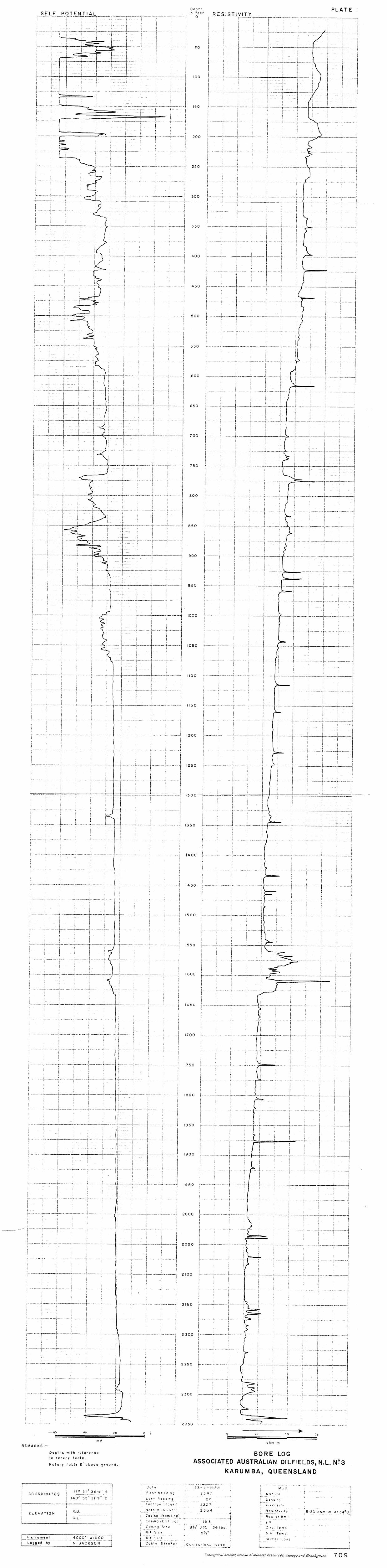
Ele~tr1eal Log (50 it = 1 in.). Plate 1.
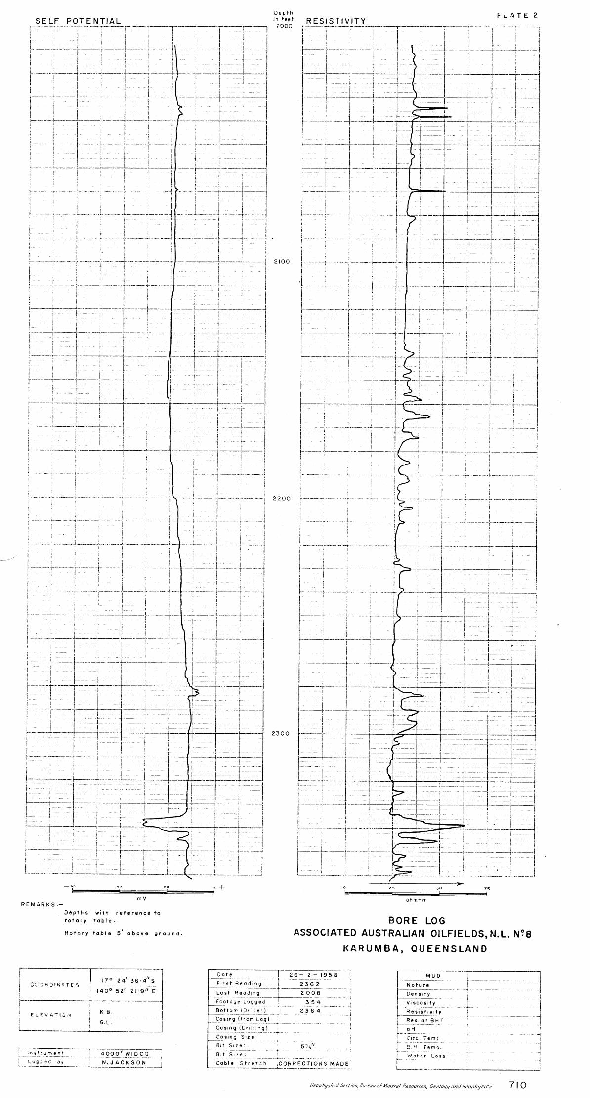
Plate 2. Electrical Log from 2008 ft. to botto!!:' cf ho' (20 ft == lin,.>.

ABSTRACT.
Associated Australian Oilfields NoL., No.8 Bore at Karumba, was logged to a total depth of 2,360 feet, by self potential and single point resistivity methods. Logging was done on a scale of 1 inch equals 50 feet to a depth of 2,347 feet and the section from 2,008 feet to 2,360 feet was logged at 1 inch equals 20 feet.
The electrical log is discussed in relation to the lithology, and although abrupt changes in electrical properties are not obvious at formation boundaries, the character of the electrical properties recorded reveal differences in sediment types.
The most important features of the log are within the sections 1,560 feet to 1,632 feet and 2,285 feet to 2,297 feet. These features correspond tn places where traces of gas and/or oil were recorded during drilling operations. The electric log offers precise depth control for these sections.
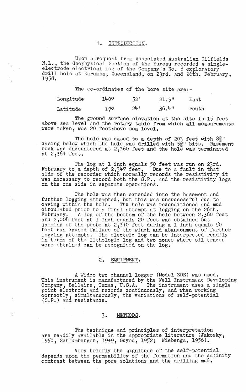
1. INTRODUCTION.
Upon a request from Associated Australian Oilfields NoL., the Geophysical Section of the Bureau recorded a singleelectrode electrical log of the Company's No., 8 exploratory drill hole at Karumba~ Queensland, on 23rd. and 26th. FebY;.Ll1ry, 1958.
The co-ordinates of the bore site are~-
Longttude
Latitude
52' 21;. ,
East
South
The ground surface elevation at the site is 15 feet above sealevel and the rotary table from which all measurements were taken, was 20 feet above sea level.
The hole was cased to a depth of 20~ feet with 8~1I casing below which the hole was drilled with 513-" bitso Basement rock was' encountered at 2,360 feet and the hole was terminated at 2,361;. feet.
The log at 1 inch equals 50 feet was run on 23rd. February to a depth of 2,31;.7 feet. Due to a fault in that side of the recorder which normally records the resistivity it was necessary to record both the S.P., and the resistivity logs on the one side in separate·operations.
The hole was then extended into the basement and further logging attempted, but this was unsuccessful due to caving within the hole. The hole was reconditioned and mud circulated prior to a final attempt at logging on the 26th. February. A log of the bottom of the hole between 2,360 feet and 2,008 feet at 1 inch equals 20 feet was obtained but jamming of the probe at 2,3~0 feet during a 1 inch equals 50 feet run caused failure of the winch and abandonment of further logging attempts. The electric log Can be interpreted readily in terms of the lithologic log and two zones where oil traces were obtEtined can be recognised on the log.
2. .§QUI PMilliI •
A Widco two channel logger (Model ZDE) was used. This instrument is manufactured by the Well Instrument DeYoloping Company, Bellaire, Texas, U.S.A. The instrument uses a single point electrode and records continuously, and when working correctly, Simultaneously, the variations of self-potential (SoP.) and resistance.
3. METHODS.
The technique and principles of interpretation are readily available in the appropriate literature (Jakosky, 1950, Schlumberger, 19lt9, Guyod, 1952; Wiebenga, 1956).
Very briefly the :Jagnitude of the self-potenti.al depends upon the permeability of the formatidn and the salinity contrast between the pore solutions and the drilling muG.

- 2 -
Reference to the self-poten~ial is in a negative sense i.e. a high S.P..1b .... ·,j a high negative value. The resistivity depends mainly upon the porosity of the formation and the salinity of the pore solutions.
4. DISCUSSION OF R~TS.
Due to the instrument fault, it was only possible to record either the S.P. or the resistivity at each logging operation. Plate 1 therefore is from a composite tracing of the logs obtained at the scale of I inch equals 50 feet to a depth of 2,347 feet, and Plate 2 from a composite tracing of the logs at a scale of 1 ~nch equals 20 feet from 2,008 to 2,}60 feet. An estimated correc~ion for cable stretch has been made on each tracing.
1H~LOG pN A SCALE OF ONE INCH EQUALS 50 FT. (PLATE 1).
The drift exhibited by the resistance log is attributed to the increasing self-induction during the re-winning of the cable not being fully compensated, while the small drift in the S.P. curve may be caused by a decrease in the permeability at depth caused by the increased compression of deeper sediments of a similar type.
Surface to 290 fget.
(1) The casing to 203 feet masks any features to this depth. The large variations in the S.P. readings may be caused primarily by electro-chemical currents due to corrosion or electrolytic action of the casing.
(2) From the bottom of the casing to 235 feet the S.P. is high and the resistance variable; this section is within. the lithologically identified lateritic zone.
(3) Below 235 feet to 467 feet the less abrupt variations in the S.P. and relatively small variation in resistivity is indicative of mixed clays and sands with occasional bands of non-permeable high resistance material i.e. at 351 and 423 feet.
(4) From 467 feet to 580 feet the variations in the S.P. accompanied by only small changes in the r~sistance indicate a more pronounced separation of the clays and sanas ove .. this section than the one immediately· overlying it, also a greater percentage of sand is indicated by the higher average S.P. val~~9.
290 feet to 1,.5'60 f~.
(1) Below 590 feet to 765 feet the ele('+"';,c log conforms with the lithologic2l data which inr'l.icc.:~os a ,t:-rcdominance of low permeability material with reasonable porosity as may be expected from shales or siltstones. The interval from 695 feet to 740 feet is characterised by what appears to be thin sandstone bands as indicated by the higher and more variable S.P. and the more variable resistivity.
(2) The interval between 765 feet and 915 feet is indicative of the predominance of sandstone. This is ver"" -~~ by the lithological log particularly below 840 feet.
- 3 -
(3) BelmlT 915 feet to 995 feet the electrical indication of less per-meB-bIe beds is attributGd to a more argillaceous sequence of sedimentation. The high resistancE:; peaks at 927~ 938 and 958 feet may identify the precise positions of thE') calcilutite bands recorded in the l~:..tholoP-ical log within this sectiono -
(4) Ii'Y>or:1l Q9r;' t:', 1 f.;'60 feci- the ,8e01' rrli="D'T' S' a "",'0> -- ,l..L ~.~' '-' q,' ",1...,.)"" .,,_,\.I . .Lv
mainly argillacGQ1J s exc('pt b,:,:rtween 995 and 1,OT? feet al~d frvm 1,332 to 1,339 fest where the variations recorded on the G.P. trace and smalJ. fluctuations in resistivity values indic2:~e a sequence of beds more arenacoous in character o The high resistiVity peaks with or without corresponding small changes in the S.P. at such I>osition~ as 1,115, J 1160, 1,228, 1,341+9 1,434 , 1,460 and 1,465 feet are most probably caused by impervious bands identified in the lithological log as limestone and siliceous shale.
1,560 feet to ~2l? feet.
The electrical log between these limits is characterised by the rslatlvely high resistivity and moderate S.P. values. This indicates a permeable zone containing salt water and possibly oil and gas. Gas and fl1.'J.orescence were also indicated in t~litholog~~al log.
l~,feet to ~~80 feet.
The SoP. log over this section exhibits only minor variations, although the resistivity curve., is relatively more variable. These, features indicate a predominantly shale sequence with occasional beds more arenaceous in character as from 2,005 to 2,023 feet and from 2,145 to 2,205 feet. Bands of relatively nonporous, non-permeable material are also present at various depths, those at 1,749, 1,877, 2 9°35, 27039, 2,0701 2,157 and 2,165 feet being the most obvious.
£.,.28Q feet:. ,to 2,2,22....feet.
The character of the combined S.P. and resistivity logs below 2,284 feet is similar to that in the log from 1,560 feet to 1,632 feet where gas and fluorescence were noted in the lithological log.
2,292 feet to ~320 fee.i.
A sequence of beds with low permeability and high porosity may be identified as predominantly shale.
~,320 feet~~~fee~.
The variations in permeability and porosity which are indicated by the logs may be correlated with the Ii thologic3~':" log which indicates the section to be predominantly arGnaceous •
.'llilLLQQ. ON A SCALE..J)F ON~E I~m1AL"S 2.Q..,l'EE.T~J:jJJ~ .. g).
The features of this log, which extends to 2,360 feet depth from 2,008 feet, are essentially similar to those shown by the earlier one inch equals 50 feet log. Some small variations occur mainly in the S. P. log wh.ich may be as a result of the reconditioning of the hole which took place bevNeen the running of the two logsv An example of these variations is the lower S. P. recorded between 2,280 and 2,284 feet and the abs r :' ~e on

- 4 -
the later Joe of ~he higher '=;c.P. behveen 2,284 and 2,296 feet} also the gradual incre3.se in S.P. indicated from 2,320 to 2,332 feet is not indicated in the later log.
Thus the only possible additionF.tl e";rJ.denco revs,:. ... .)-:;d by the 1 inch equals 20 feet log is that the re si.stt v:Lt;y h:1.gh betiATeen 2,281 and 2 ~128L+ feet would seem to be Cl. n'Jrl.·~pe;:'m.oabl€') low porosity band and tl"l';:) porsibl'3 petro'.iferous uvidence immediately underlying this and ell.countered initially was l'Jst after the recond~ticning of the hole.
Below 1,100 feet there are only three zones - from 1,560 feet to 1,632 feet, 29280 feet to 2,297 feet and 2,330 feet to 2,347 feet where the rocks are likely to be sufflci.ently permeable to yield signific[',nt quantities of flJ.id under test. The presonce of gas and fluore scence were not~jd in the lithological log between 1,560 feet and 1,632 feet and this suggest$ that fluids from this zone may contaj.n oil or gas. Whether or not further testing of this zone is warranted depends on uther fG..ctors which are outside the scope of this report.
The electrical logging at the Karumba bore waS successful ~n that a reasonable correlation between the Ii thological lug and the electI'ical log occurs and th~jse soction' where oil traces were noticed are readily recugnisable on the electric log.
The abrupt changes in electrical properti.es often associated with formation boundaries are not prominent in the log although the various sediment types are indicated by the differences in the electrical properties recordedo These are more apparent on the self-potential trace than on the resistivity trace.
6.
Guyod, Hubert, 1952
Jakosky, J.J., 1950
Schlumberger Well Surveying Corporation,
1949
Wiebenga, W.A., 1956
~RENCES.
Electrical well logging Fundamentals -a series of Articles~ o:riginal and reprint prepared by the author for Well Instrument Developing Co" Houston:Texas.
Exploration Geophysics, Trija Publ. Co., Los Angeles.
Revie'tlT of Schlumberger Well Logging Auxili.ary Methods.
Electrical Logging of No. 3 Bore~ Assoc::ated A-cwtrallan 011fie:lds, N .L .. , Ramal Queensland. Bur~Min.Reso Geolog;,r and ueophysicse Records 1956 No~ 3~