uas community testbed architecture for advanced wireless
TRANSCRIPT
Aerial Experimentation and Research Platform for Advanced Wireless
https://aerpaw.org
UAS Community Testbed Architecture
for Advanced Wireless Research with
Open-Source SDRs
Vuk Marojevic,[email protected]
Ismail Guvenc, Rudra Dutta, Mihail Sichitiu

Zipline emergency medical delivery in NC:
http://insideunmannedsystems.com/integration-
pilot-program-real-world-drone-delivery/
2
Urban Air Mobility
Uber Elevate
Urban Air
Mobility
Unmanned Aerial Systems (UAS)

UAS Providing Advanced Wireless Service
• Hot-spot wireless
access
• Post-disaster
communications
• Search and rescue
• Situational awareness
• Jammer detection
• Detection and tracking
of unauthorized UAS
3


Outline
➔ AERPAW Team and Objective
➔ AERPAW Radios
➔ Experimental Flow
➔ Research Examples
5

6
Mission
Serve as a unique technological enabler for
research in advanced wireless with UAS

AERPAW Team
8
NC
AERPAW
Site
Waveform &
Propagation
Incubation Site
(USC)
Wireless
Security and
SDR Incubation
Site (MSU)
Smart Ag IoT
Incubation
Site (Purdue)
AERPAW: Aerial Experimentation and
Research Platform for Advanced Wireless
Incubation site: develop unique testbed capabilities subsequently
deployed at main sites to support corresponding experiments

AERPAW Investigator Team
10
Ismail GuvencPI, NC State (SDRs, 4G/5G
standards, PHY/MAC)
Mihail SichitiuNC State (drones,
architecture, CentMesh)
Rudra DuttaNC State (SDN,
architecture, CentMesh)
Brian FloydNC State (mmW
circuits, arrays)
Gerard HayesNC State, WRC
(wireless and testing)
Vuk MarojevicMSU (security, SDRs,
waveforms, CORNET)
Robert MoorheadMSU (drones, FAA
ASSURE, visualization)
Tom ZajkowskiNC State (drone
operations, FAA
permitting)
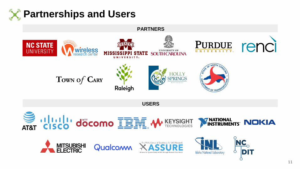
Partnerships and Users
11
USERS
PARTNERS

AERPAW: At the Crossroad of Advanced Wireless
and UAS Research
➔ 5G is unleashing new,
transformative applications
and services:
◆ Driverless cars
◆ Virtual/augmented
reality (VR/AR)
◆ Internet of things (IoT)
◆ Unmanned aerial
systems (UAS)
12
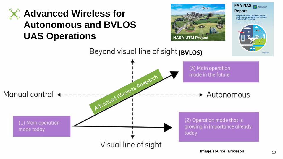
Advanced Wireless for
Autonomous and BVLOS
UAS Operations
13Image source: Ericsson
(BVLOS)
NASA UTM
NASA UTM Project
FAA NAS
Report
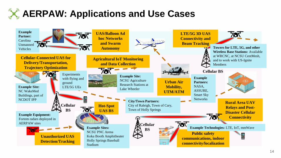
AERPAW: Applications and Use Cases
14
Rural Area UAV
Relays and Post-
Disaster Cellular
Connectivity
Cellular
BS
Agricultural IoT Monitoring
and Data Collection
Cellular
BS
Cellular BS
LTE/5G 3D UAS
Connectivity and
Beam Tracking
Hot-Spot
UAS BS
Unauthorized UAS
Detection/Tracking
Cellular-Connected UAS for
Delivery/Transportation,
Trajectory Optimization
UAS/Balloon Ad
hoc Networks
and Swarm
Autonomy
Urban Air
Mobility,
UTM/ATM
Public safety
communications, indoor
connectivity/localization
Example Site:
NC WakeMed
Buildings, part of
NCDOT IPP
Example Equipment:
Fortem radars deployed in
AERPAW sites
Example Sites:
NCSU PNC Arena
Koka Booth Amphitheater
Holly Springs Baseball
Stadium
Example
Partner:
Carolina
Unmanned
Vehicles Towers for LTE, 5G, and other
Wireless Base Stations: Available
at WRCNC, at NCSU CentMesh,
and to work with US-Ignite
Members
Example
Partners:
NASA,
ASSURE,
Smart Sky
Networks
Example Site:
NCSU Agriculture
Research Stations at
Lake Wheeler
City/Town Partners:
City of Raleigh, Town of Cary,
Town of Holly Springs
Example Technologies: LTE, IoT, mmWave
Experiments
with flying and
ground
LTE/5G UEs
Radios and Platforms
15

Platform Equipment Options for Users
16
Equipment Fixed Nodes (E.g., at Towers) Mobile Nodes (E.g., at UAVs)
SDRs NI USRP X310/N310/mmW NI USRP B210/mmW
5G NR 5G gNBs from Ericsson 5G UEs from Ericsson
RF Sensors Keysight N6841A RF Sensor Keysight Nemo RF Sensors
IoT Devices SigFox/LoRa Access Point SigFox/Lora Sensor
UAS Radar Fortem SkyDome N/A
UWB TimeDomain P410/P440 radios TimeDomain P410/440 radios
WiFi Sniffers WiFi Pineapple WiFi Pineapple
Bring your own device (BYOD) experiments will also be supported if they satisfy criteria

17
USRP X310 (fixed
nodes)
➔ Up to 160 MHz of
bandwidth
➔ Frequency range:
DC to 6 GHz (with
daughterboards)
➔ 2 Channels
➔ Kintex-7 FPGA
USRP N310 (fixed
nodes)
➔ Supports 4 channels
for MIMO operation
➔ Up to 100 MHz of
bandwidth/channel
➔ Frequency range: 10
MHz to 6 GHz
➔ Stand alone
(embedded) or host-
based (network
streaming) operation
➔ Remote management
capability
USRP 5G mmW
(expected, fixed
& mobile nodes)➔ Up to 400 MHz
bandwidth
➔ Expected center
frequency: 28 GHz
➔ We anticipate
payload will be
similar to USRP
X310 series
➔ Considered for
both at towers and
drones
USRP B205mini /
B210 (mobile nodes)➔ Up to 56 MHz of
bandwidth
➔ Frequency range: 70
MHz to 6 GHz
➔ B210 supports 2
Channels for MIMO
➔ Spartan-6 FPGA
AERPAW SDRs from National Instruments

Custom Millimeter-Wave Extenders for USRPs➔ mmW beamforming for UAS is critical; however, low-cost beamforming solutions
which easily interface with USRP are still being brought to market.
➔ We plan to develop custom beamforming modules suitable for UAS using a mixture
of commercial off-the-shelf (COTS) parts.
18
Co-PI Brian Floyd,
NCSU

Communications Experiment Software
20
Software we will integrate and provision to experimenters
➔ srsLTE, 4G now, 5G in the future
➔ Open air interface (OAI), 4G and 5G software suites
Experiment support software we will develop
➔ Waveforms
➔ Adapted protocols for supporting research and standardization
Software developed by users

Keysight RF Sensors at Ground/Aerial Nodes
(a) Drone tracking RF N6820E sensor from Keysight, (b) Example use for
UAS localization/tracking. Can be used to sense any other fixed/mobile RF
source, e.g. for interference localization.21
Keysight 4G/5G network measurement
solutions for commercial BS coverage
experiments at aerial platforms

SigFox IoT and Fortem Radar
22
SigFox: Major
applications in
agriculture (Purdue,
NCSU), Signals in
the Soil, and
broadly in UAS
based monitoring
Fortem: A NCDOT
IPP partner, detection
of unauthorized or
non-cooperating UAS

UWB Transceivers and WiFi Sniffers
23
Time Domain P440 radios
➔ Frequency: 3.1 GHz - 4.9
GHz
➔ 2 GHz of instantaneous
bandwidth
➔ 2 cm ranging precision
over 100
WiFi Pineapple
➔ Frequency: 2.4 GHz and 5
GHz WiFi
➔ Can capture probe requests
from all WiFi-equipped mobile
devices
➔ Applications in search and
rescue, occupancy monitoring
Image Source:
Guvenc et al., 2017
Localizing mobile
phones with WiFi
sniffers
Image Source: Guvenc et al., 2018
UWB RSS vs
height and
distance

Fixed Nodes
➔ Provides the users a
programmable fixed node
➔ Consists of:
• Physical Host (workstation)
• Radios
• Antennas
• Tower
➔ Optionally, steerable directional
antennas
➔ The operator loads VM Image to
the fixed node physical host
through Testbed Backplane
PH
Radio 1
Radio 2
Fixed
Node
Tower
Radio n
Antennas
RF Cables/
Waveguides
To/From
AERPAW
Backplane
...
24
VM
Experiment
Links
RF
Monitor

Mobile Nodes Payload
➔ Provides the users a
programmable mobile node
➔ Consists of:• Companion Computer + VMs
• Radios
• Antennas
• Autopilot
➔ Optionally, steerable directional
antennas
➔ The operator loads VM Image to
the mobile node physical host
through Testbed Backplane
PH
Radio 2
Mobile
Node
Payload
Tower
Radio n
Antennas
RF Cables/
Waveguides
Companion
Computer
Cellular Links
(user,
operator)
...
Cellular
Modem 1
MAVLink over USB
Mobile Node Vehicle 25
Cellular
Modem 2VM
Radio 1
AutopilotRC
Receiver
Experiment
Links

Mobile Nodes Payload
PH
Radio 2
Mobile
Node
Payload
Tower
Radio n
Antennas
RF Cables/
Waveguides
Companion
Computer
Cellular Links
(user,
operator)
...
Cellular
Modem 1
MAVLink over USB
Mobile Node Vehicle 26
Cellular
Modem 2VM
Radio 1
AutopilotRC
Receiver
Experiment
Links➔ Cellular Link 1 under user control
➔ Cellular Link 2 under operator control• Start the experiment
• Normal termination of experiment
• Abort the experiment
➔ RC Receiver under operator control
• Abort experiment

Mobile Nodes Vehicle
• Multicopters
• Fixed wing
• Helikite
• Rover
• Bus
Mobile Node
Payload
Mobile Node Vehicles
Autopilot
27

Experiment Preparation
28
Development VMs
(Ground and Aerial
node images) – cloud
Develop
Emulate
Submit
Sandbox
Observe
Retrieve
Results
Sandbox VMs
(real radio, real drones
minus props)
– indoor facility
Emulation VMs (emulated
radio, emulated drones,
real code) – cloud
Testbed
(real everything)
Specify nodes, desired mapping,
equip with AERPAW software
tools and drivers, program
Test with real drivers, actual
hardware (tutorial and sanity)
Test with real drivers, realistic
hardware emulation
(AERPAW safety check)
$
$
$
$$$$
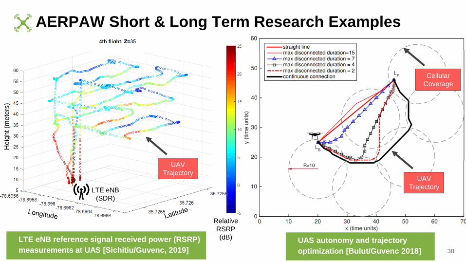
AERPAW Short & Long Term Research Examples
30
LTE eNB reference signal received power (RSRP)
measurements at UAS [Sichitiu/Guvenc, 2019]
UAS autonomy and trajectory
optimization [Bulut/Guvenc 2018]
He
igh
t (m
ete
rs)
Relative
RSRP
(dB)
LTE eNB
(SDR)
Cellular
Coverage
UAV
Trajectory
UAV
Trajectory

31
Wireless Security Incubation Site @ MSU
•Aerial communications security– PHY layer and protocol security
– Link and system reliability in harsh signaling environment
– Counter UAS systems
– Standardization
•Air interface & protocol design– Parameter exposure, incl. perform.
measurement counters and KPIs
– Adaptive waveforms and protocols
– Smart interferers
Research ParkResearch
Park
Research Park, Mississippi Sate/City of Starkville, MS

We want to work with you!
➔ Developer
➔ User
➔ Collaborator
➔ Supporter
➔ ...
32
Students, postdocs, research faculty, …