u1.0 – item u2.0 – applicant u3.0 – location...
TRANSCRIPT

Permit No. 18664 Agenda Item No. 8D
David R. Williams, P.E. Page 1
Meeting of the Central Valley Flood Protection Board December 16, 2011
Staff Report – Encroachment Permit
California Department of Transportation, District 10 State Route 99 Manteca Widening Project – South Fork of South Littlejohns
Creek, San Joaquin County, CA U1.0 – ITEM Consider approval of Permit No. 18664 (Attachment B). U2.0 – APPLICANT California Department of Transportation, District -10 U3.0 – LOCATION The project is located at the South Fork of South Littlejohns Creek and SR99 in San Joaquin County California (Attachment-C). U4.0 – DESCRIPTION The proposed project consists of widening the existing bridge crossing over the South Fork South Little Johns Creek by 35 ft, 4 in within the median to provide an additional 12 ft lane and 10 ft shoulder in each direction of travel, separated by a concrete barrier (Type 60A Modified). Approximately 14 CY of rock slope protection will be placed within the north abutment, approximately 20 ft beyond the existing bridge edges. The concrete slope protection will have a cut off wall depth of 4 ft. Vegetation within the project footprint will be cleared to allow for equipment to access the area and complete construction. After construction, the disturbed soils will be re-vegetated with grasses. 5.0 – PROJECT ANALYSIS The following project analyses have been made based on the review of the available technical information provided by the applicant and the applicants engineer HDR, Inc. This Bridge is a widening project of the North Bound and South Bound existing bridge of Highway – 99. The plan is to close the gap between the two 37 foot- 8 inch outer bridges with the median widening and to continue the top of roadway deck at the 1.5

Permit No. 18664 Agenda Item No. 8D
David R. Williams, P.E. Page 2
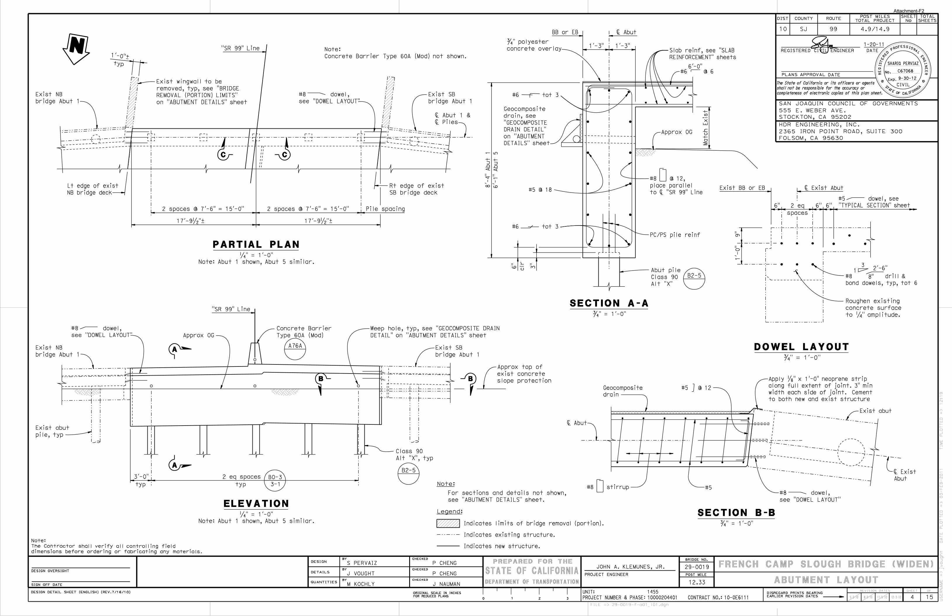
percent drainage slope. Under Title-23; Code of Regulations, Section 128(10)(B): “When an existing bridge being widened does not meet the clearance requirement above the design flood plane, the bottom structural members of the added section may be no lower than the bottom structural members of the existing bridge, except as may be caused by the extension of existing sloped structural members.” This is the case for this project. (See Atachment-F; Figure 3). Cal Trans will restore all levee slopes and roadways to pre-project condition and follow all standards and guidelines as applicable, in Title 23 of the California Water Code for construction activities on levees and within the floodway. The relevant Title 23 sections are: • 112. Streams Regulated and No permissible Work Periods • 115. Dredged Spoil, and Waste Material • 116. Borrow and Excavated Activities – Land and Channel • 121. Erosion Control • 128. Bridges • 130. Patrol Roads and Access Ramps 5.1 – Background The California Department of Transportation (CalTrans) and the Federal Highway Administration, in cooperation with the City of Manteca, San Joaquin County, and the San Joaquin Council of Governments propose to widen State Route 99 to six lanes within the median from Austin Road interchange in the City of Manteca (post Mile 4.9) to the Arch Road interchange in the City of Stockton (post mile 15.0). the total length of the proposed project also incorporates a number of structural and operational improvements to overcrossings and interchanges throughout the project area, specifically at Lathrop Road, Main Street and French Camp Road. State Route 99 is the principle north/ south highway traversing the major cities within California’s Central Valley. This specific permit application deals with one of many crossings within the CVFPB jurisdiction, namely the South Fork of South Littlejohns Creek. 5.2 – Hydraulic Analysis The design hydraulic study for this project was prepared by HDR Engineering Inc. in Folsom, California and dated July 1, 2011 and revised August 25, 2011. A HEC-RAS Model was used to determine the water surface profile. The designers estimated design flow for the 1 percent chance event (100 year storm) is: 2,600 cfs utilizing FEMA flow rates. However, the Department of Water Resources, Flood Channel Design Flows of 1985 dictate that the combined outflow of Lone Tree Creek and North & South Forks of south Littlejohns Creek is only 1,750 cfs. This is the design flow that the Board would accept. So the model run by CalTrans consultant engineer is very conservative.

Permit No. 18664 Agenda Item No. 8D
David R. Williams, P.E. Page 3
The design flow has a small enough magnitude and a small debris load as stated by San Joaquin County Flood Control and Water Conservation District dated August 31, 2011 (per Attachment-H) that per Title-23, Code of Regulations, Section 128(10)(A) the freeboard clearance (distance from the Design Water Surface Elevation to the Bridge Soffit (The low chord elevation) maybe 2.0 feet. In the HEC-RAS model, utilizing the high hundred year flow of 2,600 cfs, we find the bridge upstream proposed soffit elevation of 29.84 feet and the models water surface elevation of 28.72 feet for the existing and proposed conditions. This equates to a freeboard clearance of 1.12 feet. At the downstream outlet of the proposed bridge, the soffit elevation is 30.10 feet with the models water surface elevation of 28.21 feet for existing and proposed conditions. This equates to a freeboard clearance of 1.89 feet. Given that this project design storm of 2,600 cfs has been designed with a storm 1.5 times higher than what is allowed (1,750 cfs), Board staff is in agreement with the lesser freeboard and the intent of the Title-23, Code of Regulations has been met. Pier scour potential: Given the design storm of 2,600 cfs, existing and proposed velocities are 6.3 fps which are on the erosive edge of the channel. In the Hydrology and Hydraulic Report, under findings & Conclusion (page 13 & 14 of the report) the total scour is; Location Total Scour Left Abutment 3.85 ft. Pier-1 5.18 Pier-2 5.18 Pier-3 5.18 Right Abutment 3.57 Cal Trans consultant, HDR Inc., recommends that Rock Rip-Rap Slope Protection be provided to eliminate scour potential at the bridge crossing. That rock treatment should occur 20 feet upstream of the bridge centerline to 20 feet downstream and that a concrete cut-off wall be applied adjacent to and along the full length of the existing cut-off wall in Bent -2 (see Attachment-F; General Plan, Sheet-1). The HEC-RAS files for this reach show a “Manning’s Roughness Coefficient” of 0.04 which is smooth for Grouted Rock Rip-Rap. If this is the case then, the permit will reflect very little rock exposure in this formed concrete. 5.3– Geotechnical Summary Blackburn Consulting prepared the Final Foundation Report on January 6, 2011 (their File No. 1201.7c). The consultant retained Precision Drilling to drill and sample two exploratory borings at the site to characterize the subsurface conditions and obtain samples for laboratory testing. The drillers used a CME 75 truck-mounted rig to drill the borings using 8-inch outside diameter hollow stem auger.

Permit No. 18664 Agenda Item No. 8D
David R. Williams, P.E. Page 4
Laboratory Testing consisted of:
• Moisture Content and Unit Weight • Grain Size Analysis • Atterberg Limits • Unconfined Compressive Strength • Triaxial Shear Strength • Corrosivity (ph, Resistivity, Sulfates and Chlorides)
Local Geology consists of underlain sediments of the Pleistocene-age Modesto Formation. These sediments are alluvium comprised mostly of sand and clay. The subsurface soils are: Depth Type 5.5’ to 6.5’ Medium density silty sand fills 10.0’ Stiff lean clay fills
54.0’ interlayered very stiff lean clay to sandy lean clay with thin layers of medium dense poorly graded sand/ silts.
Deeper hard sandy lean clay and very dense clayey sand
Water levels were encountered at 43.0 to 45.0 feet. The site does not lie within or adjacent to an Earthquake Fault Zone for fault rupture hazard. The 1.5:1 and flatter canal slopes have a low to nonexistence design peak ground acceleration. 5.4 – Staff Comments The project has little effect on the Flood Control System and is an improvement. 6.0 – AGENCY COMMENTS AND ENDORSEMENTS: The comments and endorsements associated with this project, from all pertinent agencies are shown below: • A U.S. Army Corps of Engineers comment letter is expected to be received prior to
the December 2, 2011 Board meeting and shall be incorporated by reference to Permit No. 18663 as Exhibit A.
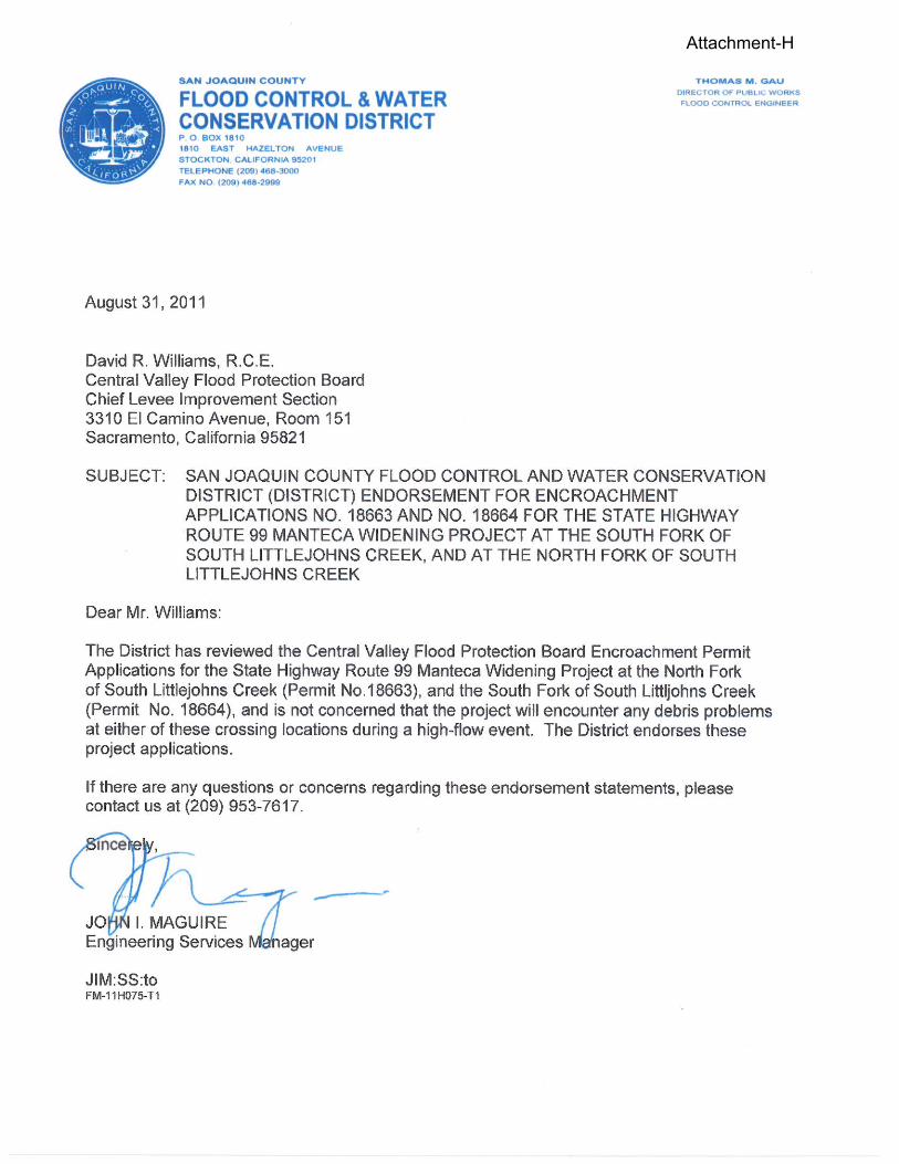
• The San Joaquin County Flood Control & Water Conservation District has endorsed this project with conditions which have been incorporated into the permit as (Attachment-B Exhibit-B).
6.1 – Owners of the property on which the project is located Cal Trans District 10 in Stockton
Permit No. 18664 Agenda Item No. 8D
David R. Williams, P.E. Page 5
Lagorio Properties LP APN 201-050-07 Joe Marchesotti CO INC. APN 201-020-05 7.0 – PROPOSED CEQA FINDINGS: Board staff has prepared the following CEQA Findings: The Board, as a responsible agency under CEQA, has reviewed Draft and Final Initial Study/Mitigated Negative Declaration (IS/MND, SCH Number: 2009112045, November 2009, March 2010) and the Mitigation Monitoring Plan for the State Route 99 Manteca Widening Project prepared by the lead agency, Caltrans. These documents, including project design, may be viewed or downloaded from the Central Valley Flood Protection Board website at http://www.cvfpb.ca.gov/meetings/2011/12-02-2011.cfm under a link for this agenda item. These documents are also available for review in hard copy at the Board and the Caltrans District 10 offices. Caltrans has determined that the project would not have a significant effect on the environment and adopted the IS/MND on March 18, 2010 and subsequently filed a Notice of Determination on March 26, 2010 with the State Clearinghouse. Board staff finds that although the proposed project could have a potentially significant effect on the environment, there will not be a significant effect in this case because revisions in the project have been made by or agreed to by the project proponent. The project proponent has incorporated mandatory mitigation measures into the project plans to avoid identified impacts or to mitigate such impacts to a point where no significant impacts will occur. These mitigation measures are included in the project proponent’s Mitigation Monitoring Plan and address impacts to biological resources, hazards and hazardous materials, and noise. The description of the mitigation measures are further described in the adopted Mitigation Monitoring Plan. 8.0 – SECTION 8610.5 CONSIDERATIONS 1. Evidence that the Board admits into its record from any party, State or local public
agency, or nongovernmental organization with expertise in flood or flood plain management: The Board will make its decision based on the evidence in the permit application and attachments, this staff report, and any other evidence presented by any individual or group.
2. The best available science that related to the scientific issues presented by the
executive officer, legal counsel, the Department or other parties that raise credible scientific issues.
The accepted industry standards for the work proposed under this permit as regulated by Title 23 have been applied to the review of this permit.

Permit No. 18664 Agenda Item No. 8D
David R. Williams, P.E. Page 6
3. Effects of the decision on the entire State Plan of Flood Control:
This project has no negative impacts on the State Plan of Flood Control. Both hydraulic and structural impacts from the project construction are negligible.
4. Effects of reasonable projected future events, including, but not limited to, changes
in hydrology, climate, and development within the applicable watershed:
Climate change issues have not been taken into account in the hydraulic analysis for this project; however, it is assumed to be inland past the point tidal influence raises in WSE, and due to the excessive amount of freeboard in the channel at this location, the project would have an ample factor of safety built into it. Climate change WSE raises are only estimated from 6-inches to 1-foot of impact and would be well within the freeboard of this project in the event that tidal influences did reach further inland than expected. There are no other foreseeable projected future events that would impact this project.
9.0 – STAFF RECOMMENDATION Staff recommends that the Board adopt the CEQA findings, approve the permit conditioned upon receipt and review of a favorable U.S. Army Corps of Engineers 208.10 comment letter and direct staff to file a Notice of Determination with the State Clearinghouse. 10.0 – LIST OF ATTACHMENTS A. Resolution No. (None required under consent items) B. Draft Permit No. 18664
Exhibit A – U.S. Army Corps of Engineers 208.10 Comment Letter Exhibit B – San Joaquin County Flood Control & Water Conservation District, letter dated December 27, 2010.
C. Location Map D. Vicinity Map E. Bridge Project cover sheet. F. Construction Drawings. Figs. 3&4 G. HEC-RAS Water Surface Plan & Cross Section for Bridge H. S.J.Co. Flood Control & Water Conservation District letter dated Aug. 31, 2011 from
John Maguire, Engineering Services Manager. I. Photo

Permit No. 18664 Agenda Item No. 8D
David R. Williams, P.E. Page 7
Report Completed by: David R. Williams, P.E. Design Review: David R. Williams, P.E. Enviromental Review: James Herota, E.S. and Andrea Mauro, E.S. Document Review: Eric Butler, P.E. – Supervising Engineer Len Marino, P.E. – Chief Engineer

Page 1 of 5 DWR 3784 (Rev. 9/85)
DRAFT STATE OF CALIFORNIA
THE RESOURCES AGENCY THE CENTRAL VALLEY FLOOD PROTECTION BOARD
PERMIT NO. 18664 BD This Permit is issued to:
California Department of Transportation 2015 East Shields Avenue, Suite A-100 Fresno, California 93728-5428
To widen the existing bridge crossing over the South Fork South Little Johns Creek by 35 ft, 4 in within the median to provide an additional 12 ft lane and 10 ft shoulder in each direction of travel, separated by a concrete barrier (Type 60A Modified). Approximately 14 CY of rock slope protection will be placed within the north abutment, approximately 20 ft beyond the existing bridge edges. The concrete slope protection will have a cut off wall depth of 4 ft. South Fork South Littlejohns Creek and SR99 (Section 29, T1S, R7E, W, San Joaquin County Flood Control and Water Conservation District, Littlejohns Creek, San Joaquin County).
NOTE: Special Conditions have been incorporated herein which may place limitations on and/or require modification of your proposed project as described above.
(SEAL)
Dated: _________________________ ______________________________________________ Executive Officer
GENERAL CONDITIONS: ONE: This permit is issued under the provisions of Sections 8700 – 8723 of the Water Code. TWO: Only work described in the subject application is authorized hereby. THREE: This permit does not grant a right to use or construct works on land owned by the Sacramento and San Joaquin Drainage District or on any other land. FOUR: The approved work shall be accomplished under the direction and supervision of the State Department of Water Resources, and the permittee shall conform to all requirements of the Department and The Central Valley Flood Protection Board.

Page 2 of 5 DWR 3784 (Rev. 9/85)
FIVE: Unless the work herein contemplated shall have been commenced within one year after issuance of this permit, the Board reserves the right to change any conditions in this permit as may be consistent with current flood control standards and policies of The Central Valley Flood Protection Board. SIX: This permit shall remain in effect until revoked. In the event any conditions in this permit are not complied with, it may be revoked on 15 days’ notice. SEVEN: It is understood and agreed to by the permittee that the start of any work under this permit shall constitute an acceptance of the conditions in this permit and an agreement to perform work in accordance therewith. EIGHT: This permit does not establish any precedent with respect to any other application received by The Central Valley Flood Protection Board. NINE: The permittee shall, when required by law, secure the written order or consent from all other public agencies having jurisdiction. TEN: The permittee is responsible for all personal liability and property damage which may arise out of failure on the permittee’s part to perform the obligations under this permit. If any claim of liability is made against the State of California, or any departments thereof, the United States of America, a local district or other maintaining agencies and the officers, agents or employees thereof, the permittee shall defend and shall hold each of them harmless from each claim. ELEVEN: The permittee shall exercise reasonable care to operate and maintain any work authorized herein to preclude injury to or damage to any works necessary to any plan of flood control adopted by the Board or the Legislature, or interfere with the successful execution, functioning or operation of any plan of flood control adopted by the Board or the Legislature. TWELVE: Should any of the work not conform to the conditions of this permit, the permittee, upon order of The Central Valley Flood Protection Board, shall in the manner prescribed by the Board be responsible for the cost and expense to remove, alter, relocate, or reconstruct all or any part of the work herein approved. SPECIAL CONDITIONS FOR PERMIT NO. 18664 BD THIRTEEN: If the construction project extends onto land owned in fee and/or easement by the Sacramento and San Joaquin Drainage District acting by and through the Central Valley Flood Protection Board (Board), the permittee should secure an easement, license, or temporary entry permit from the Board prior to commencement of work. Contact Angelica Aguilar at (916) 653-5782. FOURTEEN: All work approved by this permit shall be in accordance with the submitted drawings and specifications except as modified by special permit conditions herein. No further work, other than that approved by this permit, shall be done in the area without prior approval of the Central Valley Flood Protection Board. FIFTEEN: Prior to demolition and/or construction activities any and all easements, both temporary and permanent, shall be obtained by the applicant. SIXTEEN: There shall be no plantings within the project area under this permit, except that of native grasses, which may be required for slope protection. SEVENTEEN: The permittee shall defend, indemnify, and hold the Central Valley Flood Protection Board and the State of California, including its agencies, departments, boards, commissions, and their respective officers, agents, employees, successors and assigns (collectively, the "State"), safe and harmless, of and from all claims and damages related to the Central Valley Flood Protection Board's approval of this permit, including but not limited to claims related to the California Environmental Quality Act. The State expressly reserves the right to supplement or take over its defense, in its sole discretion.

Page 3 of 5 DWR 3784 (Rev. 9/85)
EIGHTEEN: The mitigation measures approved by the CEQA lead agency and the permittee are found in the Final Initial Study/Mitigated Negative Declaration adopted by the CEQA lead agency. The permittee shall implement all such mitigation measures. NINETEEN: The permittee is responsible for all liability associated with construction, operation, and maintenance of the permitted facilities and shall defend and hold the Central Valley Flood Protection Board and the State of California; including its agencies, departments, boards, commissions, and their respective officers, agents, employees, successors and assigns (collectively, the "State"), safe and harmless, of and from all claims and damages arising from the project undertaken pursuant to this permit, all to the extent allowed by law. The State expressly reserves the right to supplement or take over its defense, in its sole discretion. TWENTY: The Central Valley Flood Protection Board, Department of Water Resources, and the San Joaquin CountyFlood Control and Water Conservation District shall not be held liable for damages to the permitted encroachment(s) resulting from releases of water from reservoirs, flood fight, operation, maintenance, inspection, or emergency repair. TWENTY-ONE: No construction work of any kind shall be done during the flood season from November 1 to April 15 without prior approval of the Central Valley Flood Protection Board. TWENTY-TWO: Prior to start of any demolition and/or construction activities within the floodway, the applicant shall provide the Central Valley Flood Protection Board with two sets of layout plans for any and all temporary, inchannel cofferdam(s), gravel workpad(s), work trestle(s), scaffolding, piles and/or other appurtenances that are to remain in the floodway during the flood season from November 1 through April 15. TWENTY-THREE: A civil engineer registered in the State of California representing the permittee shall provide periodic reports and records to the Department of Water Resources that are acceptable to the Central Valley Flood Protection Board which certifies that all work accomplished by contract to the permittee was thoroughly inspected and performed in accordance with submitted drawings, specifications, and permit conditions. TWENTY-FOUR: Debris that may accumulate on the permitted encroachment(s) and/or any temporary falsework within the floodway shall be cleared off and disposed of outside the floodway after each period of high water. TWENTY-FIVE: The permittee shall contact the Department of Water Resources by telephone, (916) 574-0609, and submit the enclosed postcard to schedule a preconstruction conference. Failure to do so at least 10 working days prior to start of work may result in delay of the project. TWENTY-SIX: The permittee shall provide supervision and inspection services acceptable to the Central Valley Flood Protection Board. TWENTY-SEVEN: Temporary staging, formwork, stockpiled material, equipment, and temporary buildings shall not remain in the floodway during the flood season from November 1 to April 15. TWENTY-EIGHT: Cleared trees and brush shall be completely burned or removed from the floodway, and downed trees or brush shall not remain in the floodway during the flood season from November 1

Page 4 of 5 DWR 3784 (Rev. 9/85)
to April 15. TWENTY-NINE: Fill material shall be placed only within the area indicated on the approved plans. THIRTY: Backfill material for excavations shall be placed in 4- to 6-inch layers and compacted to at least the density of the adjacent, firm, undisturbed material. THIRTY-ONE: Density tests by a certified materials laboratory will be required to verify compaction of backfill within the floodway. THIRTY-TWO: The soffit of the bridges shall be no lower than that of the existing adjacent bridges which is 29.24 feet, NGVD 29. THIRTY-THREE: Revetment shall be uniformly placed and properly transitioned into the bank, levee slope, or adjacent revetment and in a manner which avoids segregation. THIRTY-FOUR: Concrete Rock Rip-Rap Revetment shall be quarry stone or cobbles and only 10 percent shall be exposed above the concrete slurry surface. The rock shall at least meet the following grading: Quarry Stone Cobbles Stone Size Percent Passing Stone Size Percent Passing 15 inches; 100 15 inches; 100 8 inches; 80-95 10 inches; 55-95 6 inches; 45-80 8 inches; 35-65 4 inches; 15-45 6 inches; 10-35 2 inches; 0-15 3 inches; 1-5 THIRTY-FIVE: The revetment shall not contain any reinforcing steel, floatable, or objectionable material. Asphalt or other petroleum-based products may not be used as fill or erosion protection on the levee section or within the floodway. THIRTY-SIX: Follow Title 23; California Code of Regulations, Section 121 for Rock Rip-Rap requirements. THIRTY-SEVEN: All debris generated by this project shall be disposed of outside the floodway. THIRTY-EIGHT: The levee section shall be restored to at least the same condition that existed prior to commencement of work. THIRTY-NINE: The work area shall be restored to the condition that existed prior to start of work. FORTY: The permittee shall submit as-built drawings to the Department of Water Resources' Flood Project Inspection Section upon completion of the project.

Page 5 of 5 DWR 3784 (Rev. 9/85)
FORTY-ONE: If the project result(s) in an adverse hydraulic impact, the permittee shall provide appropriate mitigation measures, to be approved by the Central Valley Flood Protection Board, prior to implementation of mitigation measures. FORTY-TWO: In the event that levee or bank erosion injurious to the adopted plan of flood control occurs at or adjacent to the permitted encroachment(s), the permittee shall repair the eroded area and propose measures, to be approved by the Central Valley Flood Protection Board, to prevent further erosion. FORTY-THREE: The permittee shall maintain the permitted encroachment(s) and the project works within the utilized area in the manner required and as requested by the authorized representative of the Department of Water Resources or any other agency responsible for maintenance. FORTY-FOUR: The permitted encroachment(s) shall not interfere with operation and maintenance of the flood control project. If the permitted encroachment(s) are determined by any agency responsible for operation or maintenance of the flood control project to interfere, the permittee shall be required, at permittee's cost and expense, to modify or remove the permitted encroachment(s) under direction of the Central Valley Flood Protection Board or Department of Water Resources. If the permittee does not comply, the Central Valley Flood Protection Board may modify or remove the encroachment(s) at the permittee's expense. FORTY-FIVE: The permittee may be required, at permittee's cost and expense, to remove, alter, relocate, or reconstruct all or any part of the permitted encroachment(s) if removal, alteration, relocation, or reconstruction is necessary as part of or in conjunction with any present or future flood control plan or project or if damaged by any cause. If the permittee does not comply, the Central Valley Flood Protection Board may remove the encroachment(s) at the permittee's expense. FORTY-SIX: If the project, or any portion thereof, is to be abandoned in the future, the permittee or successor shall abandon the project under direction of the Central Valley Flood Protection Board and Department of Water Resources, at the permittee's or successor's cost and expense. FORTY-SEVEN: The permittee shall comply with all conditions set forth in the letter from the U.S. Army Corps of Engineers dated xxxxxxxx, 2011, which is attached to this permit as Exhibit A and incorporated by reference. FORTY-EIGHT: The permittee shall comply with all conditions set forth in the San Joaquin County Flood Control and Water Conservation District letter dated December 27, 2010 and letter, and letter dated August 31, 2011 which is attached to this permit as Exhibit B and Attachment H and is incorporated by reference. FORTY-NINE: The permittee should contact the U.S. Army Corps of Engineers, Sacramento District, Regulatory Branch, 1325 J Street, Sacramento, California 95814, telephone (916) 557-5250, as compliance with Section 10 of the Rivers and Harbors Act and/or Section 404 of the Clean Water Act may be required. FIFTY: This permit shall run with the land and all conditions are binding on permittee's successors and assigns.


Attachment-C

Attachment-D

Attachment-E

12’
Lane
12’
Lane
12’
Lane Shld
10’
1’-0"
110’-8"
12’
Lane
12’
Lane
12’
LaneShld
10’
37’-8"– 37’-8"–
1’-0"
A
C
A
min,typ
2’-0"
at Bent 2 only
Exist conc collar
at Bent 2 only
Exist grade beam
651+00 652+00
"SR 99" Line
-1.5%–-1.5%–
35’-4"– median widening
C
E
TYPICAL SECTION
1" = 10’
A
B
D
C
Legend:
E
1" = 20’
1’
To Stockton
To Modesto
12’
12’
12’
10’
D
D
1" = 20’
PLAN
"SR 99" Line
Exist toe of slope
Exist top of slope
Exist toe of slope
Exist toe of slope Exist toe of slope
Exist top of slopeExist top of slope
Exist top of slope
SECTION A-A
A
No. 29-0019R
Exist NB Bridge
No. 29-0019L
Exist SB Bridge
A
10’
12’
12’
12’
1’
to remainExist MBGR
to remainExist MBGR
Elev 32.07–
Elev 32.06–
� Exist 35’-0"– � Exist
12’-0"–
35’-0"–
F
G
G
10°– skew
N 02°49’30" W
(Mod)
Type 60A
Barrier
Concrete
G
GENERAL PLAN
1’-
1�
"
typ
Detail 1
"SR 99" Line
deck elev
Top of conc
DETAIL 1
�" = 1’-0"
overlay, typ
concrete
�" polyester
BB "SR 99" Sta 651+22.69
EB "SR 99" Sta 652+01.19
deck as shown in "DETAIL 1".
Elevation is at top of concrete
Type 60A (MOD)
Concrete Barrier
Temporary Railing (Type K), see "ROAD PLANS".
Existing Metal Guard Bridge Railing to remain.
Rock Slope Protection, see "ROAD PLANS".
Indicates new structure.
Indicates existing structure.
Exist PG Exist PGLittlejohns
Creek
South Fork South
Match existing PG and cross slope.
Limits of exist SB bridge Limits of exist NB bridge
SB Bridge NB Bridge
Concrete Barrier Type 60C, see "ROAD PLANS"
1
and not on the roadway portion.
shall be used on the bridges only
Concrete Barrier Type 60A (Mod)
Note:
typ
skew,
6°45’40"
"ROAD PLANS" and "DETAIL 1"
4" communications conduit, see
7’-4�"–
Shld
7’-4�"–
Shld
E
D
7’-4�
"–
7’-4�
"–
Remove & reconstruct existing cut-off wall at Abutment 1
of existing SB bridge see "ABUTMENT DETAILS" sheet.
Notes:
2.
1.
For "PILE DATA", see "FOUNDATION PLAN" sheet.
For "GENERAL NOTES", see "DECK CONTOURS" sheet.
Existing Metal Beam Guard Railing to be removed, see "ROAD PLANS".
Existing Metal Beam Bridge Railing to be removed and posts to be salvaged.
FRENCH CAMP SLOUGH BRIDGE (WIDEN)
12.33
29-0019
US
ER
NA
ME
=>jvought
DEPARTMENT OF TRANSPORTATION
PREPARED FOR THE
STATE OF CALIFORNIAPROJECT ENGINEER
DESIGN OVERSIGHT
SIGN OFF DATE
DESIGN
DETAILS
QUANTITIES
BY CHECKED
SPECIFICATIONS
CHECKED
PLANS AND SPECS
COMPARED
BY
BY
LAYOUT
29-0019-a-gp01.dgnFILE =>
BRIDGE NO.
CHECKED
CHECKEDBY
BY
POST MILES
0 1 2 3
DIST COUNTY ROUTESHEET TOTAL
NoTOTAL PROJECT SHEETS
POST MILES
PLANS APPROVAL DATE
REGISTERED CIVIL ENGINEER
The State of California or its officers or agents
completeness of electronic copies of this plan sheet.
shall not be responsible for the accuracy or
DATE
TI
ME
PL
OT
TE
D
=>
DA
TE
PL
OT
TE
D
=>
12:18
03-
FE
B-2011
JOHN A. KLEMUNES, JR.
J VOUGHT
ORIGINAL SCALE IN INCHES
FOR REDUCED PLANS
FACTOR DESIGNLOAD & RESISTANCE
M KOCHLY
S PERVAIZ
S PERVAIZ
T KENG
T KENG
J MANISCALCO
P CHENG
P CHENG
J NAUMAN
SHARIQ PERVIAZ
C67068
9-30-12
15
dimensions before ordering or fabricating any materials.
The Contractor shall verify all controlling field
Note:
10 SJ 99
DISREGARD PRINTS BEARING
EARLIER REVISION DATES
SHEET OFDESIGN GENERAL PLAN SHEET (ENGLISH) (REV.7/16/10) UNIT:
PROJECT NUMBER & PHASE: 10-0E6111CONTRACT NO.:
1455
10000204401
LIVE LOADING: HL93 W/"LOW-BOY";
PERMIT DESIGN VEHICLE
REVISION DATES
5-3-10 8-2-10 11-5-10
HDR ENGINEERING, INC.
2365 IRON POINT ROAD, SUITE 300
FOLSOM, CA 95630
STOCKTON, CA 95202
SAN JOAQUIN COUNCIL OF GOVERNMENTS
555 E. WEBER AVE.
T
CIVIL
RE
GIS
TE
RE
DP
ROFESSIONAL
EN
GI
NE
ER
S
TA
EOF CALIF
ORNIA
No.
Exp.
12-3-10
Indicates Rock Slope Protection, see "ROAD PLANS".
Indicates limits of remove asphalt concrete surfacing (2"–),
prepare concrete bridge deck surface, place �" min polyester
concrete overlay and groove polyester concrete overlay.
min polyester concrete overlay and groove polyester concrete overlay.
Indicates limits of prepare concrete bridge deck surface, place �"
Datum Elev 0.00
651+00 652+00
20’-3"–
BB EB
20’-3"–
along "SR 99" Line
19’-0"– 19’-0"–
Abut 1 Bent 2 Bent 3
Approximate OG
Bent 4 Abut 5
78’-6"– measured
G
F
Limits of Concrete
Barrier Type 60A (Mod)
BB
SB bridge to remain undamaged
Exist concrete slope protection at
on "FOUNDATION PLAN" sheet
See "HYDROLOGIC SUMMARY TABLE"
4.9/14.9
1-20-11
Concrete slab, typ
CIP/Reinforced
Attachment-F1
"SR 99" Line
ELEVATION
SB bridge deck
Rt edge of exist
PARTIAL PLAN
"SR 99" Line
17’-9�"–
2 spaces @ 7’-6" = 15’-0"
� Piles
� Abut 1 &
Pile spacing
NB bridge deck
Lt edge of exist
3’-0"
typ
Note: Abut 1 shown, Abut 5 similar.
�" = 1’-0"
17’-9�"–
2 spaces @ 7’-6" = 15’-0"
B
bridge Abut 1
Exist SB
bridge Abut 1
Exist NB
2 eq spaces
typ 3-1
B0-3
1’-3"
� Abut
SECTION A-A
6"
3"
clr
1’-3"
to � "SR 99" Line
place parallel
#8 @ 12,
#6 @ 66’-0"
BB or EB
PC/PS pile reinf
#5 @ 18
#6 tot 3
#6 tot 3
concrete overlay
�" polyester
Note:
Indicates new structure.
Indicates existing structure.
Indicates limits of bridge removal (portion).
Legend:
to both new and exist structure
width each side of joint. Cement
along full extent of joint. 3" min
Apply �" x 1’-0" neoprene strip
drain
Geocomposite
#8 stirrup
Exist abut
� Abut
#5 @ 12
�" = 1’-0"
SECTION B-B
#5
�" = 1’-0"
DETAILS" sheet
on "ABUTMENT
DRAIN DETAIL"
"GEOCOMPOSITE
drain, see
Geocomposite
see "ABUTMENT DETAILS" sheet.
For sections and details not shown,
ABUTMENT LAYOUT
DETAIL" on "ABUTMENT DETAILS" sheet
Weep hole, typ, see "GEOCOMPOSITE DRAIN
B2-5
Alt "X", typ
Class 90
B2-5
Alt "X"
Class 90
Abut pile
Type 60A (Mod)
Concrete Barrier
A76A
Concrete Barrier Type 60A (Mod) not shown.
Note:
slope protection
exist concrete
Approx top of
on "ABUTMENT DETAILS" sheet
REMOVAL (PORTION) LIMITS"
removed, typ, see "BRIDGE
Exist wingwall to be
Approx OG
Approx OG
DOWEL LAYOUT
2 eq
spaces
6" 6"
9"
1’-
0"
8"
2’-6"3
1
� Exist AbutExist BB or EB
6" "TYPICAL SECTION" sheet
#5 dowel, see
bond dowels, typ, tot 6
#8 drill &
�" = 1’-0"
see "DOWEL LAYOUT"
#8 dowel,
see "DOWEL LAYOUT"
#8 dowel,
see "DOWEL LAYOUT"
#8 dowel,
1’-0"–
typ
4
REINFORCEMENT" sheets
Slab reinf, see "SLAB
Note: Abut 1 shown, Abut 5 similar.
�" = 1’-0"
Match
Exist
Abut
� Exist
8’-
4" Abut 1
6’-
1" Abut 5
to �" amplitude.
concrete surface
Roughen existing
DEPARTMENT OF TRANSPORTATION
29-0019-f-a01_l01.dgnFILE =>
TI
ME
PL
OT
TE
D
=>
DA
TE
PL
OT
TE
D
=>
12:19
03-
FE
B-2011
US
ER
NA
ME
=>jvought
BRIDGE NO.
POST MILE
DESIGN
DETAILS
QUANTITIES
BY
BY
BY
CHECKED
ORIGINAL SCALE IN INCHES
FOR REDUCED PLANS0 1 2 3
CHECKED
CHECKED
PREPARED FOR THE
STATE OF CALIFORNIAPROJECT ENGINEER
DESIGN OVERSIGHT
SIGN OFF DATE
J VOUGHT
JOHN A. KLEMUNES, JR.
FRENCH CAMP SLOUGH BRIDGE (WIDEN)
12.33
29-0019
DIST COUNTY ROUTESHEET TOTAL
NoTOTAL PROJECT SHEETS
POST MILES
PLANS APPROVAL DATE
REGISTERED CIVIL ENGINEER
The State of California or its officers or agents
completeness of electronic copies of this plan sheet.
shall not be responsible for the accuracy or
DATE
M KOCHLY J NAUMAN
S PERVAIZ P CHENG
P CHENG
SHARIQ PERVIAZ
C67068
9-30-12
5-3-10 8-2-10
HDR ENGINEERING, INC.
2365 IRON POINT ROAD, SUITE 300
FOLSOM, CA 95630
STOCKTON, CA 95202
SAN JOAQUIN COUNCIL OF GOVERNMENTS
555 E. WEBER AVE.
15
dimensions before ordering or fabricating any materials.
The Contractor shall verify all controlling field
Note:
10 SJ 99
DISREGARD PRINTS BEARING
EARLIER REVISION DATES
SHEET OFUNIT:
PROJECT NUMBER & PHASE:
DESIGN DETAIL SHEET (ENGLISH) (REV.7/16/10)REVISION DATES
CONTRACT NO.: 11-5-10
1455
10000204401 10-0E6111
T
CIVIL
RE
GIS
TE
RE
DP
ROFESSIONAL
EN
GI
NE
ER
S
TA
EOF CALIF
ORNIA
No.
Exp.
12-3-10
C C
B
A
A
bridge Abut 1
Exist SB
bridge Abut 1
Exist NB
pile, typ
Exist abut
4.9/14.9
1-20-11
Attachment-F2

ONE COMPANY | Many Solutions
SR-99 Widening Post Mile 5.3 to Post Mile 15.0San Joaquin County
Proposed Conditions Appendix FSouth Fork South Littlejohns Creek
Attachment-G1

ONE COMPANY | Many Solutions
SR-99 Widening Post Mile 5.3 to Post Mile 15.0San Joaquin County
Appendix G
South Fork South Littlejohns Creek Scour Plot
Attachment-G2
Attachment-H

Attachment-I