twoyearsof ers-1 data exploitation - esa data exploitation twoyearsof ers-1 data exploitation...
TRANSCRIPT
Two Years of ERS-1 Data Exploitation
M. Albani, V. Beruti & S. D'EliaERS Exploitation Division, ESRIN, Frascati, Italy
Reprinted from ESABulletin No. 77

ers-1 data exploitation
Two Years of ERS-1 Data Exploitation
M. Albani, V. Beruti & S. D'EliaERS Exploitation Division, ESRIN, Frascati, Italy
The ERS-1mission has fully lived up to expectations and today, after twoyears of operations, it continues to demonstrate the ability of such asophisticated remote-sensing system to provide valuable earthobservation data to several categories of users, ranging from the realtime operators involved in meteorological, oceanographic and environmental applications, to long-term research-project groups workingoff-line.
The ERS-1system is also being exploited for awide range of commercialapplications, thereby opening up new horizons in the earth-observationfield. Its success is further underlined by the very large number ofnational and foreign stations acquiring or planning to acquire ERS-1data, already allowing coverage of the majority of globe's land masses.They represent by far the largest community of international operatorscovered by a single project.
ESRIN, via its ERS Exploitation Division, has operational responsibilityfor the ERS-1 Payload Data Ground Segment as well as the related UserServices.
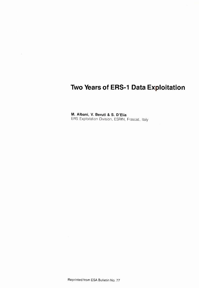
Figure 1. Schematic of theoverall ERS-1ground
segment
GROUND STATIONS
FUCINOMASPALOMASTROMSOGATINEAUPRINCE ALBERT
SALMIJAERVI
FAST DELIVERY PRODUCTS
The Payload Data Ground SegmentThe overall ERS-1 Payload Data GroundSegment is composed of the following facilities:- the ESRIN ERS Central Facility (EECF)- the ESA Ground Stations network- the ESA Processing and Archiving Facilities
(PAFs)- the National and Foreign stations.
Figure 1 shows the overall interfaces betweenthese facilities and their relationship to the UserCommunity.
The ESRIN ERS Central Facility (EECF)The EECF, located in Frascati, includes theUser Services, the Product Control Service(PCS), and the Reference System. It provides:- the user interface- definition on tasks for the whole ERS
Ground Segment
RAWDATAFROMSTATIONS
'PROCESSINGANDARCHIVINGFACILITIES
• D-PAF- f·PAF-1-PAF• UK·PAF
OFF LINE PRODUCTS
e bulletin 77
- rrussion planning in conjunction with theMission Control Centre at ESOC
- management of a facilities network for theacquisition, archiving, processing anddistribution of fast-delivery and off-lineproducts
- coordination of the national and foreignstations network
- routine monitoring of sensors- fast-delivery and off-line product quality
checks- the interface to the industrial consortium
charged with the promotion and distributionof data to commercial users
- maintenance of data-processing softwarefor the entire ESA network.
activities in conjunction with the industrialconsortium for the ERS-1 commercialapplications development, including thepreparation of materials for symposia,conferences and public-relations purposes.
The Product Control Service's operational tasksinclude the monitoring and control of ERSdataproduct quality and assessment of thecompliance of system performance with thesystem specifications. Another of its main rolesis to assess instrument behaviour and therelated margins. This information representsvital feedback for future programmes,including the analysis and development ofalgorithms for calibration and validation
activities.
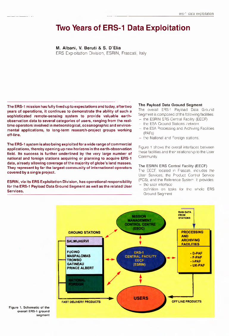
The Maspalomas Station,in the Canary Islands
The User Services unit is responsible forplanning the ERS-1mission in line with the userrequests and for scheduling the world-widedata acquisition accordingly. In addition, itsupports the end users, maintains thecentralised catalogue of acquisition andproduction, and handles user requests andproduct orders.
Another important activity of the User Servicesunit at ESRIN is the support it provides fortraining programmes for Developing Countriesin the application and exploitation of ERS data.The User Services also covers the promotional
The Product ControlService uses a range ofsystems, including the socalled 'Reference System'for the High- and Low-RateFast-Delivery Processingchains, which alsosupports the maintenanceof the operational softwareinstalled at the ESAGround Stations.
The ESA station networkThe ESA station networkhas been set up not only toensure that the satellitetelemetry data are correctlyacquired along the orbits,but also to allow themaximum coverage overthe European area for theSynthetic Aperture Radar(SAR) and Low Bit Rate(LBR) payload dataacquisitions.
The ERS-1 payload datanetwork, managed byESRIN, includes sixground stations, sited at
Salmijaervi (Kiruna, Sweden), Fucino (Italy),Maspalomas (Canary Islands), Trornse(Norway), and Gatineau and Prince Albert(Canada). These stations have already beenoperational for two years.
Except for Salmijaervi, which is operated byESOCand is fully dedicated to ERSoperationsand telemetry, tracking and control (TT&C)activities, all of the other stations are multimission in nature. Under contract to ESRIN,they perform the operations and services forERS-1 payload data acquisition, processingand dissemination, as well as hosting the ESA
ers-1 data exploitation
equipment for the requisiteoperations. They also provide similar operationalservices vis-a-vis otherinternational earth-observation satellites, such asLandsat (USA), Spot(France), JERS-1 (Japan),and Tiros (USA).
The sharing of tasks andresponsibilities betweenthese stations takes intoaccount the constraintsrelated to the high- andlow-rate payload datacharacteristics:
Salmijaervi• Global Low Bit Rate(real-time and onboard tape-recorderdata dumping)
• Regional SAR over Northern Europe andthe North Pole
- Fucino• Regional SAR and LBR over the Mediterranean area, North Africa and Central/Southern Europe
- Maspalomas•Global LBR• Regional SAR over Northwest Africaand the Eastern Atlantic
- Trornso• ATSRdata real-time processing and ope
rational backup for Kiruna acquisitions- Gatineau
• Global LBR- Prince Albert
• Global LBR.
This network ensures global LBR data acquisition (mainly from the on-board recorder dumping) on a daily basis. The typical daily activitiesof the stations can be summarised as:
- satellite tracking and scheduled dataacquisitionrecording of the data on high-densitymagnetic tapes
- processing of the Fast Delivery (FD) Products to be made available within threehours of data sensing, to natonallynominated centres
- processing of scheduled produc:s fordistribution to users
- reporting of the activities to the EECFtransmission to the Product Control Serviceat ESRIN of relevant parameters andproducts for routine sensor-performancemonitoring.
During the first two years of operations, morethan 10000 LBR and 12000 SAR passes(typically a few minutes of transmission each)have been acquired and high-density tapescarrying approximately 40 terabytes of rawdata have been stored at the ESA archivingfacilities.
The ESA Processing and Archiving Facilities(PAFs)The PAF concept was derived from proposalsby some ESA Member States to implementfacilities dedicated to specific scientific andapplication domains, based on the existence ofgroups or institutes in their countries alreadyinternationally active in these fields. Consequently, the PAFs were established as joint
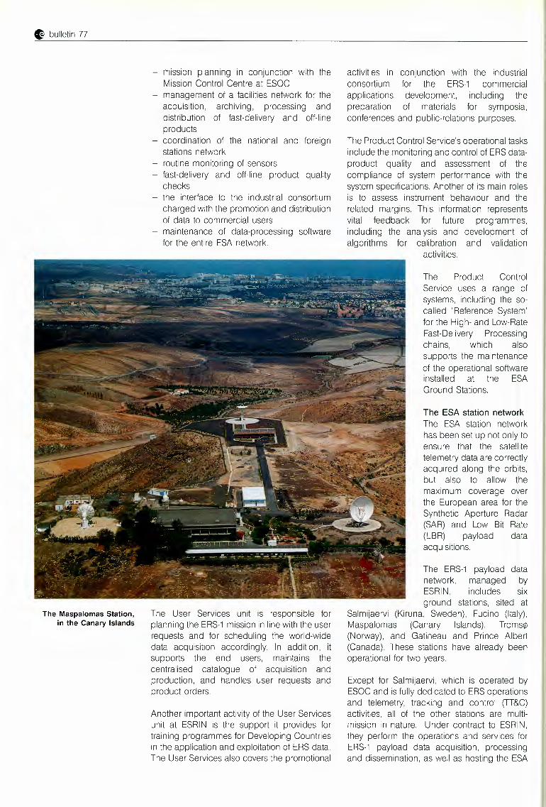
ESA's Salmijaervi groundstation on northernSweden
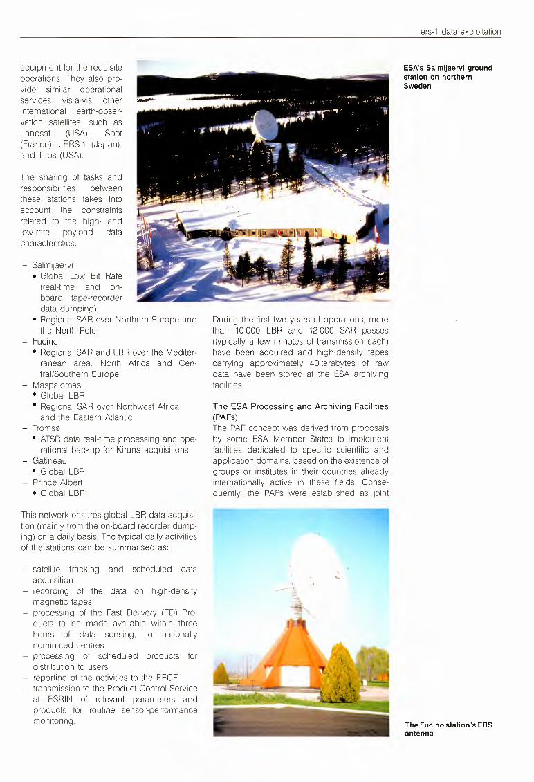
The Fucino station's ERSantenna
G bulletin 77
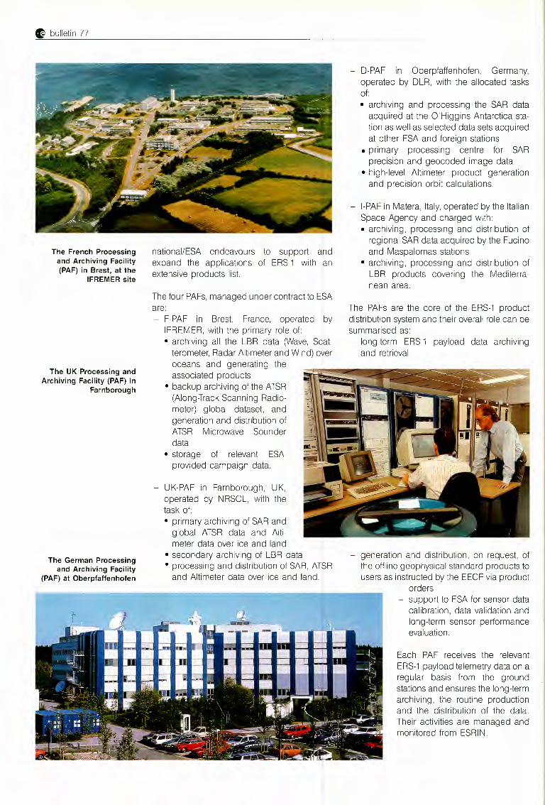
The French Processingand Archiving Facility(PAF) in Brest, at the
IFREMER site
The UK Processing andArchiving Facility (PAF) in
Farnborough
The German Processingand Archiving Facility
(PAF) at Oberpfaffenhofen
national/ESA endeavours to support andexpand the applications of ERS-1 with anextensive products list.
The four PAFs,managed under contract to ESAare:
F-PAF in Brest, France, operated byIFREMER, with the primary role of:• archiving all the LBR data (Wave, Scatterometer, Radar Altimeter and Wind) overoceans and generating theassociated products
• backup archiving of the ATSR(Alonq-Irack Scanning Radiometer) global dataset, andgeneration and distribution ofATSR Microwave Sounderdata
• storage of relevant ESAprovided campaign data.
- 0-PAF in Oberpfaffenhofen, Germany,operated by DLR, with the allocated tasksof:• archiving and processing the SAR dataacquired at the O'Higgins Antarctica station as well as selected data sets acquiredat other ESA and foreign stations
• primary processing centre for SARprecision and geocoded image data
• high-level Altimeter product generationand precision orbit calculations.
- 1-PAFin Matera, Italy,operated by the ItalianSpace Agency and charged with:• archiving, processing and distribution ofregional SAR data acquired by the Fucinoand Maspalomas stations
• archiving, processing and distribution ofLBR products covering the Mediterranean area.
The PAFs are the core of the ERS-1 productdistribution system and their overall role can besummarised as:- long-term ERS-1 payload data archiving
and retrieval
- UK-PAF in Farnborough, UK,operated by NRSCL, with thetask of:• primary archiving of SAR andglobal ATSR data and Altimeter data over ice and land
• secondary archivinq of LBR data• processing and distribution of SAR, ATSRand Altimeter data over ice and land.
- generation and distribution, on request, ofthe offline geophysical standard products tousers as instructed by the EECF via product
orders- support to ESA for sensor data
calibration, data validation andlong-term sensor performanceevaluation.
Each PAF receives the relevantERS-1payload telemetry data on aregular basis from the groundstations and ensures the long-termarchiving, the routine productionand the distribution of the data.Their activities are managed andmonitored from ESRIN.
ers-1 data exploitation
The National and Foreign stationsIn addition to the ESA station network, somenational (i.e. belonging to countries participating in the ERS-1Programme) and 1oreign(belonging to non-participating countries)ground stations have been set up or are in theprocess of being set up around the world inorder to acquire ERS-1 SAR payload data.
The current situation is summarised inTable 1.These stations operate under the termsand conditions of a standard Memorandum ofUnderstanding with ESA.
All ERS-1 ground stations receive, frcm theEECF in Frascati, the input data needed toacquire, process and distribute the SAR dataand they report back to the EECF on theirstation activities and status. These stationsgenerate and distribute products developednationally to ESA Principal Investigators, PilotProjects and commercial users. In particular,low-resolution near-real-time products aredistributed as a service from the Tromso andGatineau stations.
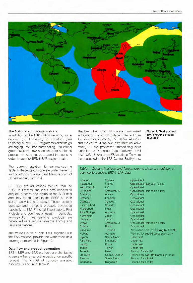
The stations listed in Table 1 will, together withthe ESA stations, provide the world-wice datacoverage presented in Figure 2.
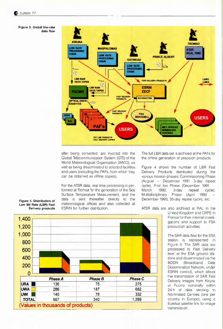
Data flow and product generationERS-1 LBR and SAR products are distributedto users either on a routine basis or on specificrequest. The full list of currently availableproducts is shown in Table 2.
The flow of the ERS-1LBR data is summarisedin Figure 3. These LBR data - obtained fromthe Wind-Scatterometer, the Radar Altimeterand the Active Microwave Instrument (in Wavemode) - are processed immediately afterreception to so-called 'Fas'. Delivery' level(UWI, URA, UWA)at the ESAstations. They arethen collected at the ERS Central Facility and,
Figure 2. Total plannedERS-1 ground-stationcoverage
Table 1. Status of national and foreign ground stationsplanned to acquire, ERS-1 SAR data
Trornse NorwayAussaguel FranceWest Freugh UKO'Higgins Antarctica, DFairbanks AlaskaCotopaxi Ecuador~~~ineau CanadaPrince Albert CanadaHyderabad IndiaAlice Springs AustraliaKumamoto JapanHatoyama JapanSyowa Antarctica, JCuiaba BrazilBangkok ThailandHobart AustraliaRiyadh Saudi ArabiaPare-Pare Indonesia Under testaeijing China Under testTaipeh Taiwan Under testTel Aviv IsraelLibreville Gabon, DLR-DPretoria South AfricaSingapore Singapore
G bulletin 77
Figure 3. Global low-ratedata flow
TROMSO
Figure 4. Distribution ofLow Bit Rate (LBR) Fast
Delivery products
For the ATSRdata, real-time processing is performed at Trornse for the generation of the SeaSurface Temperature Measurement, and thedata is sent thereafter directly to themeteorological offices and also collected atESRIN for further distribution.
KIRUNA
llASPALOllAS
after being converted, are injected into theGlobal Telecommunication System (GTS)of theWorld Meteorological Organisation (WMO), aswell as being disseminated to selected facilitiesand users (including the PAFs,from which theycan be obtained as offline copies).
The full LBR data set is archived at the PAFsforthe offline generation of precision products.
Figure 4 shows the number of LBR FastDelivery Products distributed during thevarious mission phases: Commissioning Phase(August - December 1991, 3-day repeatcycle), First Ice Phase (December 1991 -March 1992, 3-day repeat cycle),Multidisciplinary Phase (April 1992December 1993, 35-day repeat cycle), etc.
ATSR data are also archived at RAL in theUnited Kingdom and CRPE inFrance for their internal investigations and support to ESAproduction activities.
1,400 ~--------------~1,200 ,____ ----'-------------<
1,000 1------~-- -------i------1
8001-----------~---____,600<-----------4---4002000
Phase A PhaseB PhaseCURA. 136 75 275UWAD
-- ---.~-~···--~--
286 187 682UWI • 145 78 332TOTAL 567 340 1,289
(Values in thousands of products)
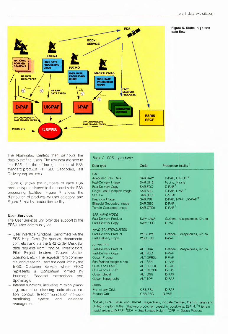
The SAR data flow for the ESAstation is represented inFigure 5. The SAR data areprocessed to Fast Deliverylevel at the ESA ground stations and disseminated via theBDDN (Broadband DataDissemination Network, underESRIN control), which allowsthe transmission of SAR FastDelivery images from Kirunaor Fucino nominally within24 h of data sensing toNominated Centres (one percountry in Europe), using aEutelsat satellite link for imagetransmission.
ers-1 data exploitation
~ ~--~ ~
••••••••• <·."'°'···.: ··.•·.·.·.·· ..·.a.·.. ·•.·.••• .•. ' ..... ".·' ..a· ..·.•.,,.. } ...
HR RAW~
11 :. ,:~T"'8/'~~~
FUCINO1.-1~~
HR RAWDATA TAPES
E~Figure 5. Global high-ratedata flow
MASPALOMAS
•/(__}/'::,:-
FASTDELIVERYPRODUCTS
~
~PROOUCTS
OFF LINE PRODUCTSFAST DELIVERYCOPIES
The Nominated Centres then distribute thedata to the final users. The raw data are sent tothe PAFs for the offline generation of ESAstandard products (PRI, SLC, Geocoded, FastDelivery copies, etc.).
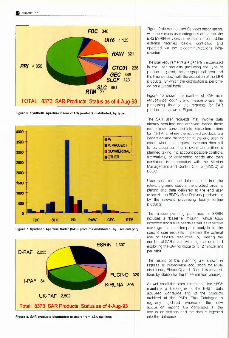
Figure 6 shows the numbers of each ESAproduct type delivered to the users by the ESAprocessing facilities. Figure 7 shows thedistribution of products by user category, andFigure 8 that by production facility.
User ServicesThe User Services unit provides support to theERS-1 user community via:
- User interface functions, performed via theERS Help Desk (for queries, documentation, etc.) and via the ERS Order Desk (fordata requests from Principal Investigators,Pilot Project leaders, Ground Stationoperators, etc.). The requests from commercial and research users are dealt with by theERSC Customer Service, where ERSCrepresents a Consortium formed byEurimage, Radarsat International andSpotimage.
- Internal functions, including mission planning, production planning, data dissemination control, telecommunication networkmonitoring, system and databasemanagement.
Table2. ERS-1products
Data type Code Production facility 1
SARAnnotated Raw Data SAR.RAW D-PAF, UK-PAF 2
Fast-Delivery Image SAR.Ul16 Fucino, KirunaFast-Delivery Copy SAR.FDC D-PAF2Single-Look Complex Image SAR.SLC D-PAF, 1-PAF2
SLC Full SAR.SLCF UK-PAFPrecision Image SAR.PAI D-PAF, 1-PAF, UK-PAF 2
Ellipsoid Geocoded Image SAR.GEC D-PAFTerrain Geocoded Image SAR.GTC01 D-PAF3
SAR WAVE MODEFast-Delivery Product SWM.UWA Gatineau, Maspalomas, KirunaFast-Delivery Copy SWM.FDC F-PAF
WIND SCA TTEROMETERFast-Delivery Product WSC.UWI Gatineau, Maspalomas, KirunaFast Delivery Copy WSC.FDC P-PAF
ALTIMETERFast-Delivery Product ALT.URA Gatineau, Maspalomas, KirunaFast-Delivery Copy ALT.FDC F-PAFOcean Product ALT.OPR02 F-PAFSea-Surface-Height Model ALT.SSH D-PAFQuick-Look SSH 4 ALT.SSHQL D-PAFQuick-Look OPR 5 ALT.QLOPR D-PAFOcean Geoid ALT.OGE D-PAFOcean Topography ALT.TOP D-PAF
ORBITPreliminary Orbit ORB.PAL D-PAFPrecise Orbit ORB.PRC D-PAF
1D-PAF, F-PAF, 1-PAFand UK-PAF, respectively, indicate German, French, Italian andUnited Kingdom PAFs; 2Back-up production capability possible at ESRIN; 31f terrainmodel exists at D-PAF; 4SSH = Sea Surface Height; 50PR = Ocean Product
0 bulletin 77
FDC 348
PR/ 4,856
1,135
RAW 321
GTC01 226GEC 446
SLCF 123SLC 891
RTM 27
TOTAL: 8373 SAR Products; Status as of 4-Aug-93
Figure 6. Synthetic Aperture Radar (SAR) products distributed, by type
4000
3500
3000
2500
2000
1500
1000
500
0FCC SLC
•Pl•P.PROJECT•COftWERCIAL•OTHER
GEC RTMPRI RAW
Figure 7. Synthetic Aperture Radar (SAR) products distributed, by user category
1-PAF 84
D-PAF 2,255
FUCINO 329
UK-PAF 2,502
Total: 8373 SAR Products; Status as of 4-Aug-93
Figure 8. SAR products distributed to users from ESA facilities
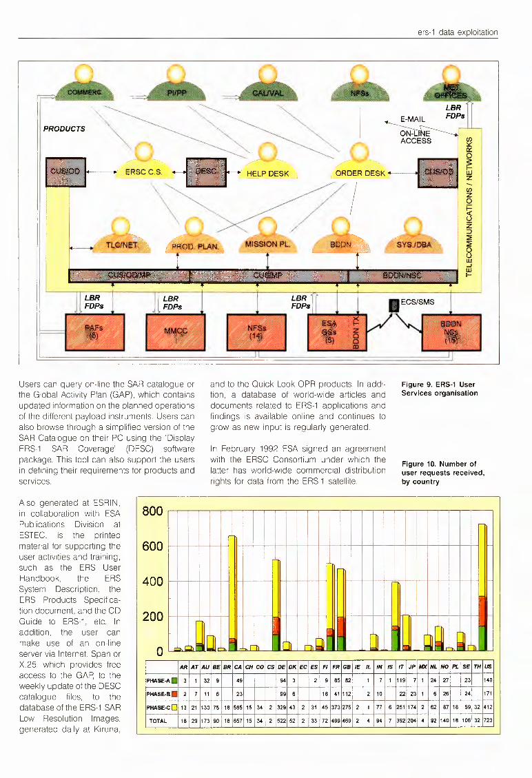
Figure 9 shows the User Services organisation,with the various user categories at the top, theERSESRINservices in the central area and theexternal facilities below, controlled andoperated via the telecommunications infrastructure.
The user requirements are generally expressedin the user requests (including the type ofproduct required, the geographical area andthe time window) with the exception of the LBRproducts, for which the distribution is performed on a global basis.
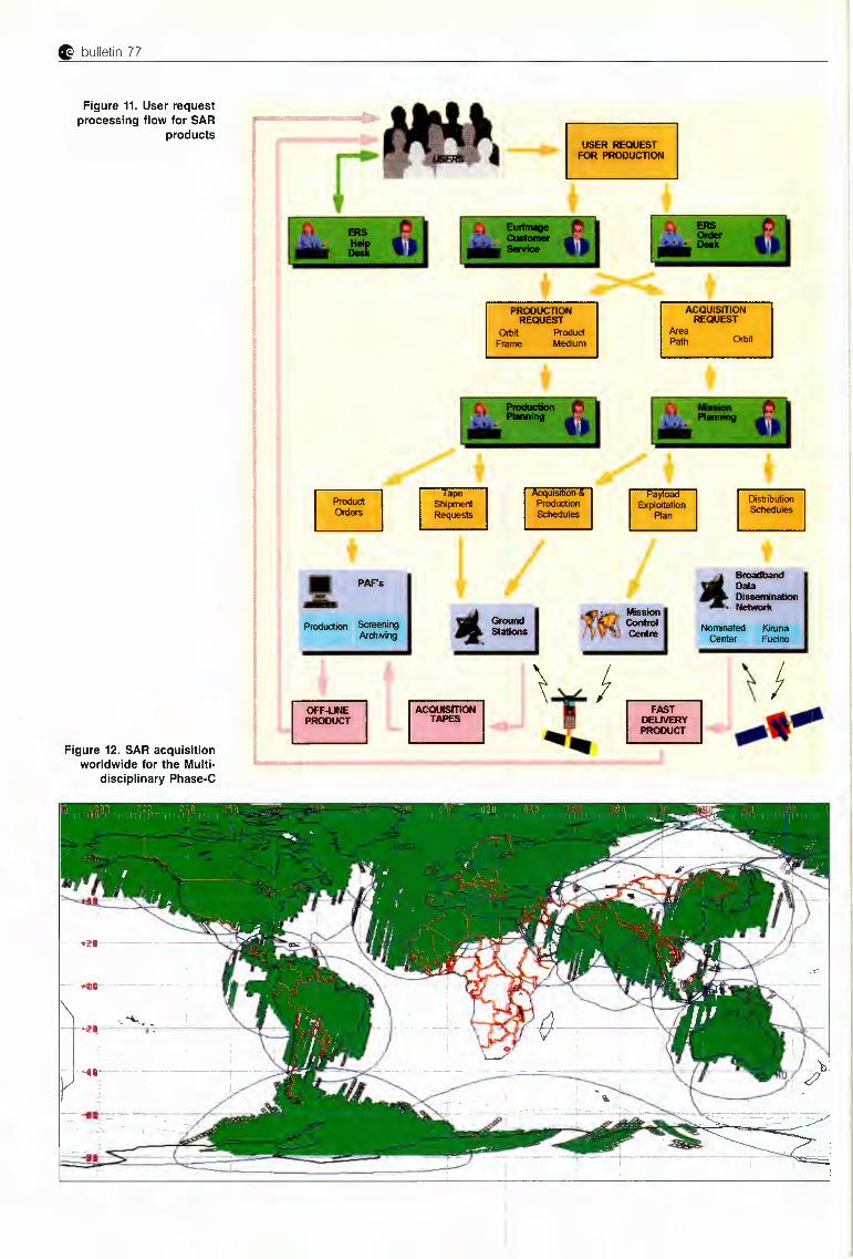
Figure 10 shows the number of SAR userrequests per country and mission phase. Theprocessing flow of the requests for SARproducts is shown in Figure 11.
The SAR user requests may involve dataalready acquired and archived: hence thoserequests are converted into production ordersfor the PAFs,where the required products aregenerated and dispatched to the end user. Incases where the request concerns data stillto be acquired, the relevant acquisition isplanned taking into account possible conflicts,alternatives, or anticipated needs and thenconfirmed in cooperation with the MissionManagement and Control Centre (MMCC) atESOC.
Upon confirmation of data reception from therelevant ground station, the product order isplaced and data delivered to the end usereither via the BOON (Fast Delivery products) orby the relevant processing facility (offlineproducts).
The mission planning performed at ESRINincludes a 'baseline' mission, which addsexpected and future needs as well as repetitivecoverage for multi-temporal analysis to thespecific user requests. It permits the optimaluse of satellite resources, by limiting thenumber of SAR on/off switchings per orbit andexploiting the SARfor close to its 12minute limitper orbit.
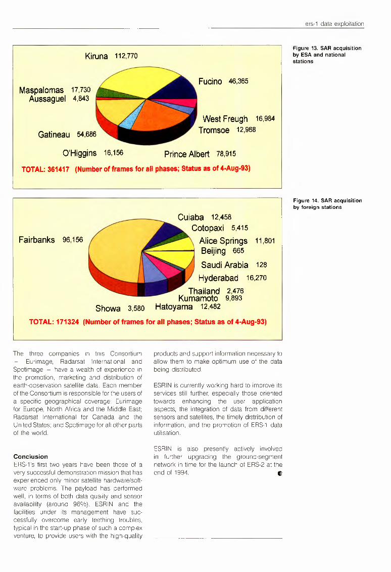
The results of this planning are shown inFigures 12 (world-wide acquisition for Multidisciplinary Phase C) and 13 and 14 (acquisitions by station for the three mission phases).
As well as all the other information, the EECFmaintains a Catalogue of the ERS-1 dataacquired worldwide and of the productsarchived at the PAFs. This Catalogue isregularly updated whenever the newacquisition reports are generated at theacquisition stations and the data is ingestedinto the database.
ers-1 data exploitation
PRODUCTS
ERSCC.S.
Users can query on-line the SAR catalogue orthe Global Activity Plan (GAP), which containsupdated information on the planned operationsof the different payload instruments. Users canalso browse through a simplified version of theSAR Catalogue on their PC using the 'DisplayERS-1 SAR Coverage' (DESC) softwarepackage. This tool can also support the usersin defining their requirements for products andservices.
HELP DESK
,.____E-MAIL~-
ACCESS . ~0:::
~z
and to the Quick Look OPR products. In addition, a database of world-wide articles anddocuments related to ERS-1 applications andfindings is available online and continues togrow as new input is regularly generated.
Figure 9. ERS-1UserServices organisation
In February 1992 ESA signed an agreementwith the ERSC Consortium under which thelatter has world-wide commercial distributionrights for data from the ERS-1 satellite.
Figure 10. Number ofuser requests received,by country
Also generated at ESRIN,in collaboration with ESAPublications Division atESTEC, is the printedmaterial for supporting theuser activities and training,such as the ERS UserHandbook, the ERSSystem Description, theERS Products Specification document, and the CDGuide to ERS-1, etc. Inaddition, the user canmake use of an on-lineserver via Internet, Span or I 0 ' ~ - - - ci.X.25, which provides freeaccess to the GAP, to theweekly update of the DESCcatalogue files, to thedatabase of the ERS-1SARLow Resolution Images,generated daily at Kiruna,
600
AR AT AU BE BR!CA CH co csloE DK EC ES Fl FR GB IE IL INjIS IT JP MX NL NO PL SE TH usPHASE-A. 3 1 32 9 49 ! 94 3 2 9 85 82 11 7 1 119 7 1 24 27 23 140
PHASE·B· I 99I
2 7 11 6 23 6, 18 41112 ! 2 10 22 23 1 6 26 24 171
PHASE-CO 13 21 130 75 18 585115 34 2 !329 43 i 2 31 45 373 275 2 1 77 6 251 174 2 62 87 18 59 32 412
TOTAL 18 29 173 90 18 657 15 34 2 152252 2 33 I 72 499 469 2 4 94 7 392 2041 4 92 140 18 106 32 723
G bulletin 77
Figure 11. User requestprocessing flow for SAR
products
r
. ,
PW.
-~,I~
Figure 12. SAR acquisitionworldwide for the Multi
disciplinary Phase-C
~ ~
ers-1 data exploitation
Kiruna 112,110
Maspalomas 17,730Aussaguel 4,843
Gatineau 54,686
O'Higgins 16,156
TOTAL: 361417 (Number of frames for all phases; Status as of 4-Aug-93)
Prince Albert 78,915
Fucino 46,365
West Freugh 16,984Tromsoe 12,968
Cuiaba 12,458Cotopaxi 5,415
Alice Springs 11,801Beijing 665
Saudi Arabia 128Hyderabad 16,270
Thailand 2,476Kumamoto 9,893
Showa 3,580 Hatoyama 12,482
TOTAL: 171324 (Number of frames for all phases; Status as of 4-Aug-93)
Fairbanks 96,156
The three companies in this ConsortiumEurimage, Radarsat International and
Spotimage - have a wealth of experience inthe promotion, marketing and distribution ofearth-observation satellite data. Each memberof the Consortium is responsible for the users ofa specific geographical coverage: Eurimagefor Europe, North Africa and the Middle East;Radarsat International for Canada and theUnited States; and Spotimage for all other partsof the world.
ConclusionERS-1's first two years have been those of avery successful demonstration mission that hasexperienced only minor satellite hardware/software problems. The payload has performedwell, in terms of both data quality and sensoravailability (around 96%). ESRIN and thefacilities under its management have successfully overcome early teething troubles,typical in the start-up phase of such a complexventure, to provide users with the high-quality
products and support information necessary toallow them to make optimum use of the databeing distributed.
ESRIN is currently working hard to improve itsservices still further, especially those orientedtowards enhancing the user applicationaspects, the integration of data from differentsensors and satellites, the timely distribution ofinformation, and the promotion of ERS-1 datautilisation.
ESRIN is also presently actively involvedin further upgrading the ground-segmentnetwork in time for the launch of ERS-2 at theend of 1994. ~
Figure 13. SAR acquisitionby ESA and nationalstations
Figure 14. SAR acquisitionby foreign stations