tweed estuary boating plan - part 5 - home - roads … · this section of the river begins at the...
TRANSCRIPT

Tweed Estuary Boating Plan 2006 - 2010 Page 113
B004AH
TUMBULGUM BRIDGE TO CONDONG BOAT RAMP

Tweed Estuary Boating Plan 2006 - 2010 Page 114

NSW Maritime
Tweed Estuary Boating Plan 2006 - 2010 Page 115
14 TUMBULGUM BRIDGE TO CONDONG RAMP (B004AH)
14.1 Description: The section of the river begins immediately upstream from the traffic bridge at Tumbulgum and extends approximately six kilometres upstream to the
Condong boat ramp. Tumbulgum is a popular recreational spot for a variety of boaters including houseboats, pleasure craft, fishing and as a launching
point for water skiers and wakeboarders. It contains the entrance to the Rous River at Tumbulgum, Dinseys and Bartletts Creeks and Sand Island.
14.2 Navigational Restrictions • There are no gazetted speed restrictions on this stretch of the river.
• Pylons of traffic bridge joining Tumbulgum to North Tumbulgum.
• A No Wash zone between the traffic bridge and the Tumbulgum boat ramp.
• Navigation aids mark the channel on the bend near Dinseys Creek and around Sand Island.
14.3 Navigational Aids At the time of writing this plan, the existing navaids consisted of:
Navaid Type Location Navaid Type Location
Yellow Aqua Buoy Adjacent to eastern foreshore near
Tumbulgum boat ramp
Port Pipe Beacon Marking the eastern end of Sand Island
No Wash Signage From Tumbulgum traffic bridge to
the boat ramp
Port Aqua Buoy Marking the western end of Sand Island
Starboard Aqua Buoys Bend near Dinseys Creek (3 each)

NSW Maritime
Tweed Estuary Boating Plan 2006 - 2010 Page 116
14.4 Compliance History
0%
10%
20%
30%
40%
50%
60%
Perc
enta
ge
Boating Licence VesselRegistration
Safety Equipment Safe BoatingBehaviour
Wash, Speed,Noise etc
Other
Type
B004AH - Infringements & Formal Warnings 1999-2004
0
1
2
3
4
5
6
7
8
9
Num
ber
Wash Distance Speed Safety Noise Pollution Other
Type
B004AH - Complaints by Type 1999-2004
Figure 18 Figure 19
Speed, safety and noise issues are prevalent in this area and are consistent with the high level of boating activity occurring here.
The high proportion of infringements and formal warnings relating to boat licences as shown in Figure 14 were mainly the result of unlicensed Personal
Watercraft riders. Only 23 complaints were registered by Maritime from 1999 – 2004. Noise complaints predominantly came from residents at
Tumbulgum.

NSW Maritime
Tweed Estuary Boating Plan 2006 - 2010 Page 117
14.5 Boat Ramps
Tumbulgum Boat Ramp - The Tumbulgum Boat Ramp suffers from a lack of available parking. There are no dedicated car/trailer parking
facilities yet there was an average of 27 boat trailers (of which 68% were registered in QLD) counted along Riverside Drive, associated side streets and
on grassy river bank areas during the survey period. A high percentage of ramp users were water skiers.
The area has a holding jetty and a number of small sandy beaches.
14.6 Values
♦ Residents value the pleasant, village-like appeal and amenity of the Tumbulgum area.
♦ Stakeholders value this section of the river as an ideal area for towing and power boating activities.
♦ Boaters throughout the estuary value the availability of modern boating facilities, and areas where families can congregate while participating in
boating related activities.
♦ The waterway in the vicinity of Tumbulgum is valued for the fishing, skiing and pleasure cruising opportunities it provides stakeholders.
♦ Houseboats anchor in this area and enjoy the village amenity.
♦ The area is valued by boaters for its boat launching facilities and its deep expansive waterway.
♦ The area is valued for the many passive recreational opportunities it provides stakeholders, for example picnicking on the river banks.
14.7 Issues
♦ The level of boating activity in the reach upstream of Tumbulgum (to Condong boat ramp) is significantly less than that at other areas of the river,
yet it is considered by users ideal for power boating, skiing and riding PWCs. There is an opportunity to encourage more use of this section and
therefore potentially relieve the more congested areas such as Tumbulgum.

NSW Maritime
Tweed Estuary Boating Plan 2006 - 2010 Page 118
♦ The Tweed River Estuary Bank Management Plan highlighted a number of areas along this reach that were subject to varying degrees of erosion.
♦ There are two boat ramps at Condong that are under-utilised, one of which the Tweed Council is considering upgrading to a regional boating
facility. Section 5.5 discusses the issue of boating facilities on the Tweed and recommends a number of considerations for Council.
♦ Issues relating to noise and boating activity at Tumbulgum are addressed in Section 12.
♦ Stakeholders have expressed concern over the impact of vessel activity on bank stability particularly between the Boat Ramp and Tumbulgum
Bridge.
♦ Conflict between skiers, wakeboarders, personal watercraft riders, house-boaters and residents at Tumbulgum.
♦ Residents have expressed concern over noise and safety issues relating to vessel activity and the impacts on their amenity.
♦ The increasing levels of boating in this section of the river pose safety concerns for all enjoying boating related activities.
14.8 Management Strategies and Action Plan
Outcome Strategies Actions Timeframe
Mitigate the risk of accidents
and/or incidents in this busy
section of the river.
Dedicated areas, education and
compliance.
Introduction of a “minimal wash” zone in the area from
Tumbulgum Bridge to Government Road.
Liaison with houseboat operators with a view to assigning
a dedicated area near the entrance to the Rous River for
houseboats to lay at anchor.
Short term
Short term
Mitigate the impact of vessel
activity on bank stability.
Vessel restrictions
Review the configuration of existing “Idle Speed Zone”
aquamarks adjacent to the bank and determine whether
Short term

NSW Maritime
Tweed Estuary Boating Plan 2006 - 2010 Page 119
Outcome Strategies Actions Timeframe
Liaison with Tweed Council to
mitigate the effect of ski boats
nosing-in to the banks.
additional marks need to be installed.
Educate waterskiers to reduce the incidence of power
turning when returning to fallen skiers.
Recommend to Tweed Council the construction of sandy
beaches between areas of revetment from the boat ramp
extending to the Tumbulgum Bridge in order to provide
dedicated picking-up and setting-down areas for skiers.
Council may seek funding assistance through the Maritime
Infrastructure Program for the construction of sandy
beaches. Recommend the strengthening of existing
revetment works and where necessary the creation of
additional work in this section.
Short term
Medium term
Reduce the impact of vessel activity
on the amenity of riverside
residents.
Education, curfew and
compliance.
Noise
Reassessment of existing
Introduction of a “No Skiing or Aquaplaning before 8am”
restriction to the urban areas of Tumbulgum (and
Murwillumbah). See Appendix A - Stakeholders’
Submissions Matrix & NSW Maritime Response, point 4.
The introduction of a noise limit of 75 dB(A) for all vessels
on this stretch of river. See Appendix A - Stakeholders’
Submissions & Response Summary Section 12.
Install signage at the ramp and at various points along the
river.
Monitor compliance.
Monitor and enforce existing irregular driving (freestyling)
regulations.
Recommend the investigation of additional launching and
Short term
Short term
}
} Ongoing
}
}
NSW Maritime
Tweed Estuary Boating Plan 2006 - 2010 Page 120
Outcome Strategies Actions Timeframe
boating restrictions and
facilities.
parking facilities to the Tweed Shire Council as it is the
agency responsible for decisions regarding such issues at
Tumbulgum.
Short term
Increase safe and environmentally
sustainable vessel activity in the
under-utilised section of river up
stream from Tumbulgum urban
area.
Educate and encourage boaters
to use this section of river.
Removal of navigation hazards.
Liaise with waterski clubs and on-water users
recommending this stretch of river as an ideal location for
skiing, power boating and riding PWCs.
Monitor usage and review impacts of increased activity
Place restrictions on other sections of the river. (See other
management sections for details.)
Recommend that Tweed Council investigate the desirability
and appropriateness of a regional boating facility at
Condong. Suggest investigation of the inclusion of a
pump-out facility, sandy beach areas from which boaters
can pick-up and drop-off skiers, grassed picnic areas,
parking, toilets etc.
Recommend rock armouring on the bank areas adjacent to
the proposed facility and the strengthening of banks where
necessary along this stretch of river in accordance with the
Tweed Bank Management Plan.
Recommend to Dept of Lands that old structures and poles
(the remnants of old lifting structures) be removed from
the river downstream from Condong.
Ongoing
Ongoing
Short term
Short term
Short term
Short term

Tweed Estuary Boating Plan 2006 - 2010 Page 121
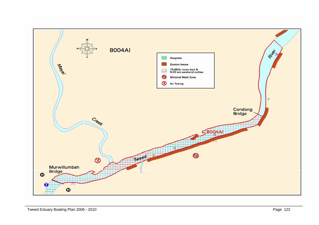
B004AI
CONDONG BOAT RAMP TO MURWILLUMBAH BRIDGE
Tweed Estuary Boating Plan 2006 - 2010 Page 122

NSW Maritime
Tweed Estuary Boating Plan 2006 - 2010 Page 123
15 CONDONG RAMP TO MURWILLUMBAH BRIDGE (B004AI)
15.1 Description: This section of the river begins at the Condong boat ramp and extends upstream to the traffic bridge at Murwillumbah. It is characterised by a straight
stretch of the river, approximately 3 kilometres in length, from the Condong Bridge to the Heritage Wharf at Murwillumbah.
15.2 Navigational Restrictions • There are no gazetted speed restrictions on this stretch of the river.
• The narrowly spaced pylons of the Condong traffic bridge represent a navigation restriction and safety issue. The Water Traffic Regulations - NSW
include rules that apply to navigation under bridges. See Appendix A - Stakeholders’ Submissions Matrix & NSW Maritime Response, point 6.
• A number of yellow aquabuoys have been spaced along the southern side of the river approximately 25 metres from the foreshore to encourage
vessels to keep vessels at the required distance from shore thereby mitigating the impact of wash on the riverbanks.
• A 75dB(A) noise limit has also been applied to this section of the river.
• A “minimal wash” zone has also been introduced to this section of the river.
15.3 Navigational Aids
At the time of writing this plan, the existing navaids consisted of:
Navaid Type Location Navaid Type Location
Yellow Aqua Buoys Along the southern side of the river approximately 25 metres from the foreshore
Starboard and Port Signage Located on the Condong Bridge
No Skiing or Aquaplaning Signage
Located on the Condong Bridge
“Waterskiing and aquaplaning prohibited between sunset and 8:00AM”
Between Murwillumbah Heritage Wharf and Murwillumbah Bridge

NSW Maritime
Tweed Estuary Boating Plan 2006 - 2010 Page 124
15.4 Boat Ramps
• Condong Boat Ramp
This is a small ramp with plenty of off-street parking. However, an average of only two car/trailers used the ramp during the survey period. Table 7
shows that this stretch of river is popular with boaters involved in towing activities. Skiers in particular desire to be located in areas that offer
landing facilities combined with grassy styled picnic areas. While there is ample grassed area for picnics etc at Condong there is little in the way of
landing areas (other than the ramp) that allows the setting down and picking up of skiers. This is in part due to the relative height of the bank.
• Condong Regional Boating Facility
This ramp has similar characteristics to the other Condong Ramp. It is a small ramp with plenty of off-street parking but little in the way of other
facilities. An average of only two car/trailers was evident during the survey period. Like the other ramp, its apparent unpopularity with water skiers
is due to there being little in the way of landing areas (other than the ramp) that allow the setting down and picking up of skiers. The Tweed
Council has proposed the construction of a “regional boating facility” at this site. A concrete pad for use by local boat builders for launching larger
vessels has already been constructed.
• Condong “back of Liquorland”
This is a private site sometimes used by the local water ski club. It has off-street parking and a narrow single lane ramp. There were no
cars/trailers evident over the survey period, but can have up to six vessels using it at various times.
15.5 Additional Infrastructure • The Heritage public wharf and pontoon are located at Murwillumbah, plus the pontoon on the opposite side of the river, both of which were
constructed with assistance from Maritime under its WADAMP fund.

NSW Maritime
Tweed Estuary Boating Plan 2006 - 2010 Page 125
15.6 Compliance History
0%
5%
10%
15%
20%
25%
30%
35%
40%
Perc
enta
ge
Boating Licence Vessel Registration Safety Equipment Safe BoatingBehaviour
Wash, Speed,Noise etc
Other
Type
B004AI - Infringements & Formal Warnings 1999-2004
0
2
4
6
8
10
12
Num
ber
Wash Distance Speed Safety Noise Pollution Other
Type
B004AI - Complaints by Type 1999-2004
Figure 20 Figure 21 This section of the river is characterised by the diverse and at times conflicting activities undertaken there, for example waterskiing, rowing, fishing,
houseboating and passive recreation. This conflict is illustrated by the types of complaints registered for this area (see Figure 17) particularly those relating to
safety, noise, distance-off and wash issues.
15.7 Values
♦ Riverside residents value the amenity of the area.
♦ Stakeholders value the ability to use the waterway without the imposition of unnecessary restrictions.

NSW Maritime
Tweed Estuary Boating Plan 2006 - 2010 Page 126
♦ Resident stakeholders value riverbank stability adjacent to their properties.
♦ This area is valued for the opportunity it provides for family enjoyment through boating, skiing, fishing and other water-related activities.
♦ Stakeholders value the long, straight and calm attributes of the river, and its suitability to a range of different water-based activities.
♦ Stakeholders value the Olympic standard rowing course facility in this reach of the river.
15.8 Issues
♦ The impact of vessel noise on the amenity of riverside living.
♦ The impact of boating activity on bank stability, particularly the southern side of the river adjacent to residential areas.
♦ The “imposition of unnecessary boating restrictions” in the area between Condong and Murwillumbah Bridges.
♦ Equity between the various users of this section of the river.
♦ Safety issues relating to waterskiing and aquaplaning under the Condong and Murwillumbah Bridges.
15.9 Management Strategies and Action Plan
Outcome Strategies Actions Timeframe
Reduction of the effects of vessels
on bank stability.
Education, vessel restrictions
and compliance.
The introduction of a “Minimal Wash” zone extending the
length of this section of river.
The installation of appropriate signage.
Development of an education campaign to coincide with
Short term
Short term

NSW Maritime
Tweed Estuary Boating Plan 2006 - 2010 Page 127
Outcome Strategies Actions Timeframe
Mitigate the risk of incidents and
accidents in this section of the
river.
Improved amenity for riverside
residents.
Education, compliance and
curfew
Noise Limit
the introduction of the “Minimal Wash” zone.
The installation of a number of buoys along the south-
eastern bank marking the distance that vessels are
required to stay from the bank.
The introduction of a time curfew on the waterway in the
urban areas of Murwillumbah (and Tumbulgum). See
Appendix A - Stakeholders’ Submissions & Response
Summary Section 4
Promote and enforce PWC regulation in relation to
no freestyling/irregular driving within 200m of residential
areas.
The introduction of a noise limit of 75 dB(A) for all vessels
on this stretch of river. See Appendix A - Stakeholders’
Submissions & Response Summary Section 12.
On-going noise testing of vessels.
Short term
Short term
On-going
Short term
On-going

Page 129
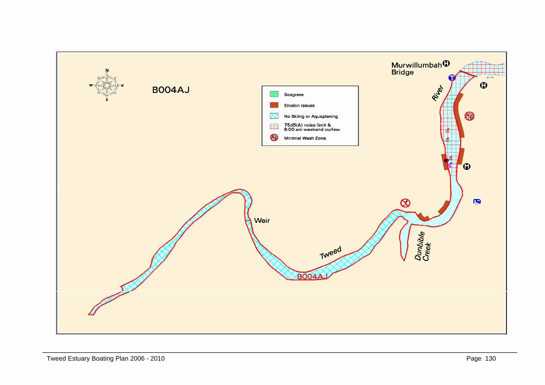
B004AJ
MURWILLUMBAH BRIDGE TO WEIR
Tweed Estuary Boating Plan 2006 - 2010 Page 130

NSW Maritime
Tweed Estuary Boating Plan 2006 - 2010 Page 131
16 MURWILLUMBAH BRIDGE TO THE WEIR (B004AJ)
16.1 Description: This section of the river begins at the traffic bridge at Murwillumbah and extends to the weir at Hindmarsh Flats, approximately four kilometres
upstream. It is characterised by steep embankments on the eastern foreshore and at the bend on the approaches to Dunbible Creek. This section has
the most concentration of residential property adjoining the river upstream of Tumbulgum.
16.2 Navigational Restrictions • The stretch from Dunbible Creek to the weir has been designated as a No Skiing or Aquaplaning zone.
• The Murwillumbah traffic bridge provides navigation restrictions in term of pylons and traversing speed.
• A navigation channel is marked in the area adjoining the Commercial Road ramp and recreation reserve.
16.3 Navigational Aids
At the time of writing this plan, the existing navaids consisted of:
Navaid Type Location
Port Aqua Buoys Designating the channel adjacent to the Commercial Road
ramp and recreation reserve
No Skiing or Aquaplaning Signage From Dunbible Creek to the Weir at Hindmarsh Flats
Starboard and Port Signage Located on each side of the Murwillumbah traffic Bridge
Yellow Aqua Marks Beginning of No Skiing or Aquaplaning zone

NSW Maritime
Tweed Estuary Boating Plan 2006 - 2010 Page 132
16.4 Compliance History
0%
5%
10%
15%
20%
25%
30%
35%
40%
45%
50%
Perc
enta
ge
Boating Licence VesselRegistration
Safety Equipment Safe BoatingBehaviour
Wash, Speed,Noise etc
Other
Type
B004AJ - Infringements & Formal Warnings 1999-2004
0
2
4
6
8
10
12
14
16
18
20
Num
ber
Wash Distance Speed Safety Noise Pollution Other
Type
B004AJ - Complaints by Type 1999-2004
Figure 22 Figure 23 Bank stability is a concern for residents on the eastern side of the river and is reflected in the number of vessel wash complaints (see Figure 19) received
during the 1999-2004 period. The narrow channel along the western side of the bank between the Commercial Road Boat Ramp and the Murwillumbah Bridge
has been the subject of complaints concerning safety issues.

NSW Maritime
Tweed Estuary Boating Plan 2006 - 2010 Page 133
16.5 Boat Ramps
• Commercial Road Boat Ramp
The Commercial Road Boat Ramp is situated south west of the Murwillumbah traffic bridge. The facility does not have dedicated car/trailer parking
facilities similar to those at Kennedy Drive and Fingal Boat Ramps, but does have enough off-street parking for up to 10 cars/trailers. It is a family
oriented facility ideal for picnics and general boating.
An average of 6 cars/trailers were counted over the survey period, significantly less than many ramps on the Tweed with less facilities.
16.6 Values
♦ This section of the river is valued as an area within which to undertake recreational pursuits such as water skiing, power boating and waterside
recreational activities.
♦ Stakeholders enjoy the amenity of riverside living.
♦ Boaters value the safe and environmentally sustainable use of this section of river.
♦ Residents value the health of the river banks in this area.
16.7 Issues
♦ Erosion issues on the eastern side of the river opposite the Commercial Road Ramp. This area was identified by the Tweed River Estuary Bank
Management Plan as being subject to “historical shoaling and that the undercutting and scarping of the bank is mainly due to increased flood
velocities”. Section 5.4 describes the causes of bank erosion and states that boat wave energy dissipates over distance. Maritime has installed
port GRP buoys marking the extent of the navigable channel situated on the western side of the river. There is significant distance between the
port buoys and the eastern shore. It should be noted that the eastern bank is situated near the outer bend of the river and would, therefore, be
more susceptible to erosion from flood events.

NSW Maritime
Tweed Estuary Boating Plan 2006 - 2010 Page 134
♦ Conflict between boaters and riverside residents, especially relating to noise and wash.
♦ The narrow channel marked by port GRP buoys on the western side of the river, downstream from the Commercial Road Boat Ramp is a safety
concern for boaters. Significant shoaling from the natural flow of the river, exacerbated by flood events has, over the years, reduced the area
available for safe boating.
♦ Safe navigation under the Murwillumbah Bridge. The bridge’s pylons are potential navigation hazards especially for skiers, aquaplaners and
wakeboarders.
16.8 Management Strategies and Action Plan
Outcome Strategies Actions Timeframe
Mitigate the risk of boating related
accidents &/or incidents at the
Murwillumbah traffic Bridge.
Educate and where necessary
enforce compliance of existing
distance-off regulations.
Review existing signage and where necessary improve or
replace, including placement of “No Towing” signs on the
bridge. See Appendix A - Stakeholders’ Submissions &
Response Summary Section 6.
Install navigation lights on both approaches to the bridge.
Monitor compliance by boaters.
Ongoing
Short term
Ongoing
Mitigate the risk of boating related
accidents &/or incidents in the
narrow channel on the western side
of the river upstream from the
Murwillumbah Bridge.
Educate boaters and review
existing navigation aid
configuration for
appropriateness.
Review depth soundings to determine most appropriate
location for port buoys.
Arrange adjustments where necessary.
Regularly monitor and review.
} Short
} term
}
} Short
} term

NSW Maritime
Tweed Estuary Boating Plan 2006 - 2010 Page 135
Reduction of the effects of vessels
on bank stability.
Education, vessel restrictions
and compliance.
The introduction of a “Minimal Wash” zone extending the
length of this section of river.
The installation of appropriate signage.
Development of an education campaign to coincide with
the introduction of the “Minimal Wash” zone.
Short term
Short term
Improved amenity for riverside
residents.
Education, compliance and
curfew
Noise Limit
The introduction of a time curfew on the waterway in to
the urban areas of Murwillumbah (and Tumbulgum). See
Appendix A - Stakeholders’ Submissions & Response
Summary Section 4
Promote and enforce PWC regulation in relation to no
freestyling / irregular driving within 200m of residential
areas.
The introduction of a noise limit of 75 dB(A) for all vessels
on this stretch of river. See Appendix A - Stakeholders’
Submissions & Response Summary Section 12.
On-going noise testing of vessels.
Short term
On-going
Short term
On-going