tutorial leica geooffice
TRANSCRIPT

7/25/2019 Tutorial Leica Geooffice
http://slidepdf.com/reader/full/tutorial-leica-geooffice 1/5
How to use Leica Geo-Office: A quick guide on the SPP processing
Before start you should make a couple of directories on your Z: drive to store the project files in,I suggest the following convention:
Z:\GMAT3700\SPPprac\
There are a number of steps, which need to be undertaken to process GPS data using LeicaGeo Office. The following is a quick outline of the steps involved:
1) Start a new project or open/update an existing project2) Import a RINEX or Leica receiver data into the project3) Export to RINEX files from the data in the opened project4) Process the selected data for SPP5) Display and print the results
6) Option: use LEICA Satellite Availability tool
STEP 1: Start a new project
LEICA Geo Office (LGO) is a software package designed to support GPS, TPS and Level dataprocessing. You can start LEICA Geo Office either from desktop shortcut or Windows startmenu.The main screen will appear, from which you will select all your different operational tasks from.
• Select New Project in the File menu.
And the following dialogue box will appear:
Type in the path name, as suggested beforehand, and then give the project a name of yourchoosing. Make sure the time zone is + 10 hours.
7/25/2019 Tutorial Leica Geooffice
http://slidepdf.com/reader/full/tutorial-leica-geooffice 2/5
• Tab to Codelist Template and make sure the Instrument Class is set to GPS500.
• Click OK.
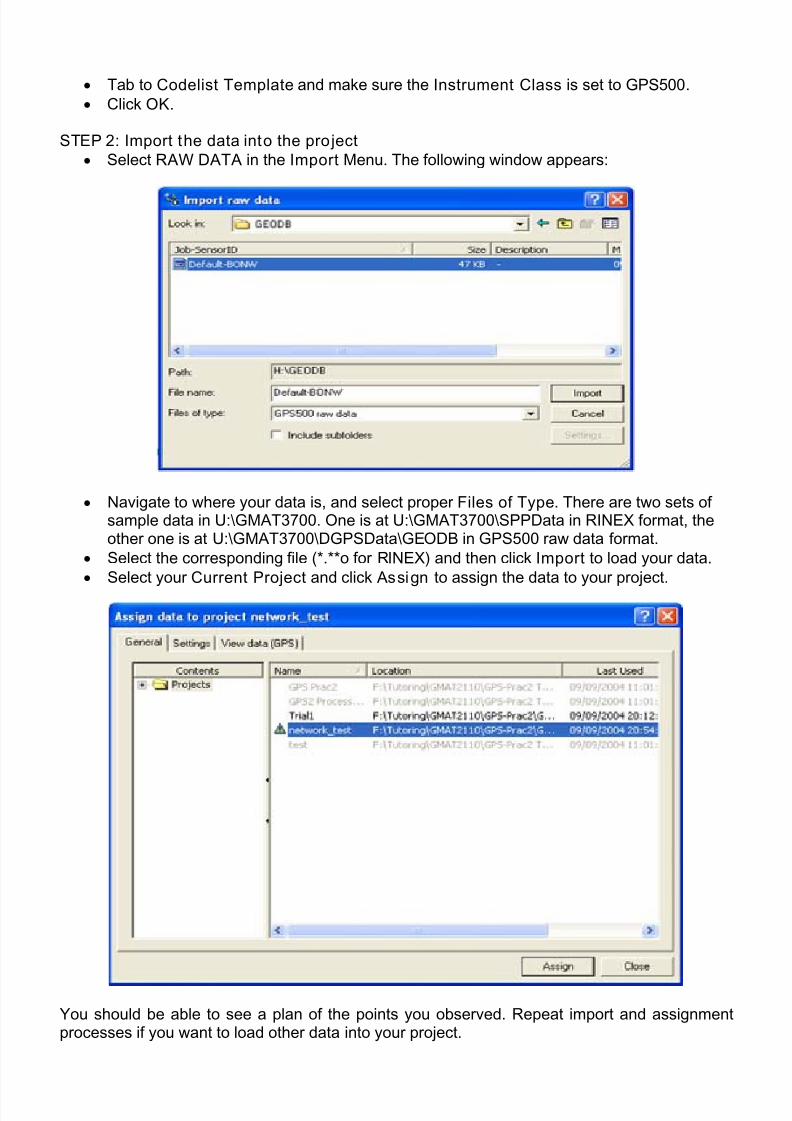
STEP 2: Import the data into the project
• Select RAW DATA in the Import Menu. The following window appears:
• Navigate to where your data is, and select proper Files of Type. There are two sets ofsample data in U:\GMAT3700. One is at U:\GMAT3700\SPPData in RINEX format, theother one is at U:\GMAT3700\DGPSData\GEODB in GPS500 raw data format.
• Select the corresponding file (*.**o for RINEX) and then click Import to load your data.
• Select your Current Project and click Assign to assign the data to your project.
You should be able to see a plan of the points you observed. Repeat import and assignmentprocesses if you want to load other data into your project.
7/25/2019 Tutorial Leica Geooffice
http://slidepdf.com/reader/full/tutorial-leica-geooffice 3/5
STEP 3: Export to RINEX fi les
The data in the opened project can be exported to RINEX files no mater which kind of formatthe original data is.• Click on the GPS-Proc tab along the bottom of the main window. A display of the observationwindows for each point should appear.
• Right-click on the bar corresponding to the data section you want to export, and select Exportto RINEX. You can also select multi data section by highlight them and in Point ID field and thenright-click to export.• Select proper location and file name, and then click save, corresponding RINEX observationand navigation files will be generated.
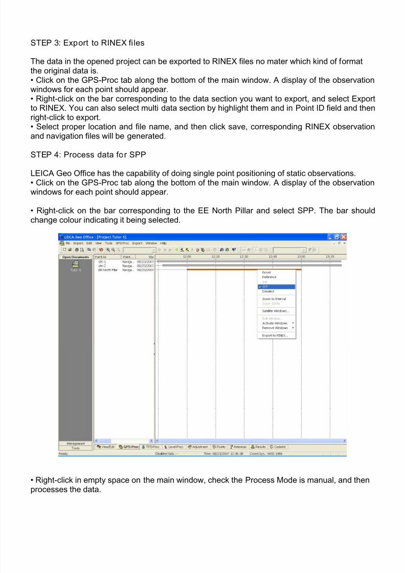
STEP 4: Process data for SPP
LEICA Geo Office has the capability of doing single point positioning of static observations.• Click on the GPS-Proc tab along the bottom of the main window. A display of the observationwindows for each point should appear.
• Right-click on the bar corresponding to the EE North Pillar and select SPP. The bar shouldchange colour indicating it being selected.
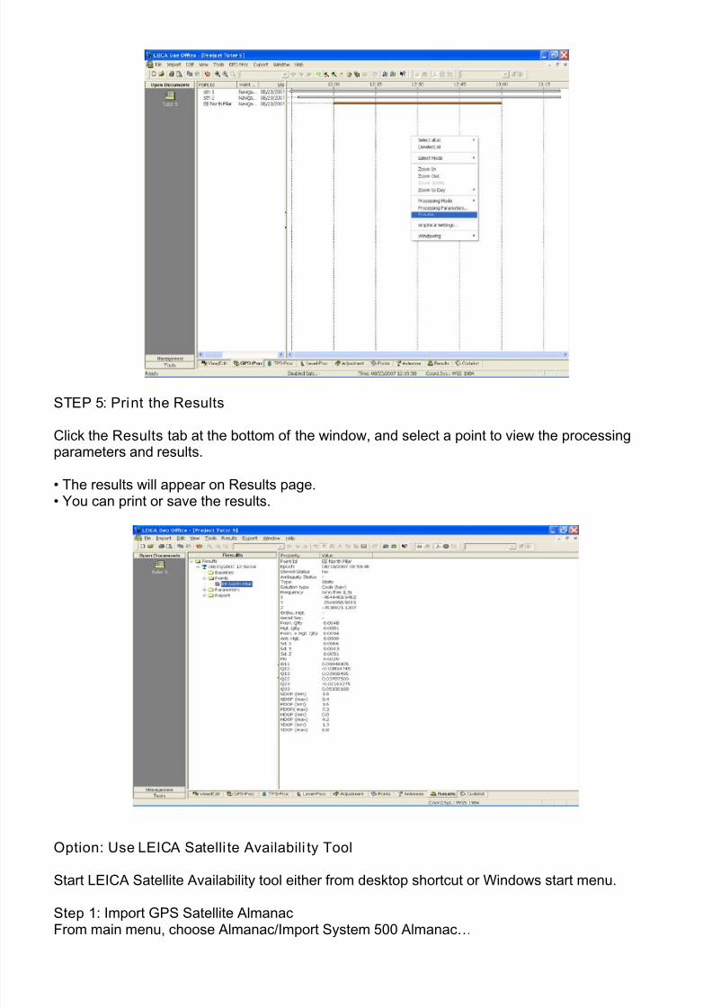
• Right-click in empty space on the main window, check the Process Mode is manual, and thenprocesses the data.
7/25/2019 Tutorial Leica Geooffice
http://slidepdf.com/reader/full/tutorial-leica-geooffice 4/5
STEP 5: Print the Results
Click the Results tab at the bottom of the window, and select a point to view the processingparameters and results.
• The results will appear on Results page.• You can print or save the results.
Option: Use LEICA Satelli te Availabili ty Tool
Start LEICA Satellite Availability tool either from desktop shortcut or Windows start menu.
Step 1: Import GPS Satellite AlmanacFrom main menu, choose Almanac/Import System 500 Almanac…
7/25/2019 Tutorial Leica Geooffice
http://slidepdf.com/reader/full/tutorial-leica-geooffice 5/5
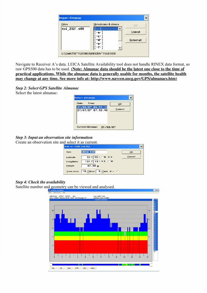
Navigate to Receiver A’s data. LEICA Satellite Availability tool does not handle RINEX data format, so
raw GPS500 data has to be used. (Note: Almanac data should be the latest one close to the time of
practical applications. While the almanac data is generally usable for months, the satellite health
may change at any time. See more info at: http://www.navcen.uscg.gov/GPS/almanacs.htm)
Step 2: Select GPS Satellite AlmanacSelect the latest almanac:
Step 3: Input an observation site informationCreate an observation site and select it as current.
Step 4: Check the availabilitySatellite number and geometry can be viewed and analysed.