tsunami hazard in central america: historical events and
TRANSCRIPT

Intergovernmental Oceanographic Commission
Workshop Report No. 278
Tsunami Hazard in Central America: Historical Events and Potential Sources
San Jose, Costa Rica 23–24 June 2016
UNESCO

Intergovernmental Oceanographic Commission
Workshop Report No. 278
Tsunami Hazard in Central America: Historical Events and Potential Sources
San Jose, Costa Rica 23–24 June 2016
UNESCO 2018

IOC Workshop Reports, 278 Paris, August 2018
English
The authors are responsible for the choice and the presentation of the facts contained in this publication and for the opinions expressed therein, which are not necessarily those of UNESCO and do not commit the Organization. Every care has been taken to ensure the accuracy of information in this publication. However, neither UNESCO, nor the authors will be liable for any loss or damaged suffered as a result of reliance on this information, or through directly or indirectly applying it. The designations employed and the presentation of the material in this publication do not imply the expression of any opinion whatsoever on the part of the Secretariats of UNESCO and IOC concerning the legal status of any country or territory, or its authorities, or concerning the delimitation of the frontiers of any country or territory.
For bibliographic purposes this document should be cited as follows:
Intergovernmental Oceanographic Commission. 2018. Tsunami Hazard in Central America: Historical Events and Potential Sources. San Jose, Costa Rica, June 23 and 24, 2016. Paris, UNESCO, 50 pp (IOC/2018/WR/278).
Published in 2018 by the United Nations Educational, Scientific and Cultural Organization 7, place de Fontenoy, 75352 Paris 07 SP
(IOC/2018/WR/278)

IOC Workshop Reports, 281 page (i)
TABLE OF CONTENTS
page
EXECUTIVE SUMMARY ........................................................................................................ 1
1. BACKGROUND .......................................................................................................... 2
2. SEISMIC SOURCES WITH TSUNAMIGENIC POTENCIAL AFFECTING CENTRAL AMERICA ............................................................................ 3
2.1 TECHNICAL DISCUSSION SESSIONS ............................................................ 4
3. TECTONIC SETTING OF CENTRAL AMERICA AND SURROUNDINGS .............................................................................................. 5
3.1 PACIFIC MARGIN: TECTONICS AND TSUNAMIGENETIC SOURCES ALONG MIDDLE AMERICA, COLOMBIA AND ECUADOR ............. 5
3.2 CARIBBEAN MARGIN: TECTONICS AND TSUNAMIGENIC SOURCES ALONG SOUTHERN CENTRAL AMERICA, COLOMBIA AND VENEZUELA .... 7
4. TSUNAMI SOURCES AGREEMENT ......................................................................... 9
4.1 PACIFIC MARGIN TECTONIC SOURCES ........................................................ 9
4.1.1 Near-field tectonic sources (less than 500 km from impact zone).............. 9
4.1.2 Far-field tectonic sources .......................................................................... 9
4.2 CARIBBEAN TECTONIC SOURCES................................................................. 9
4.2.1 Near-field tectonic sources (less than 500 km from impact zone): ............. 9
4.2.2 Far-field tectonic sources ........................................................................ 10
4.3 MODELING RESULTS .................................................................................... 11
4.3.1 Pacific Nearfield Sources ........................................................................ 11
4.3.1.1GUANICA: Middle America Trench 1 (MAT1) from Guatemala to Nicaragua (Fig. 7a and 7b) .............................. 11
4.3.1.2NICOBA: Middle America Trench 2 (MAT2) Nicoya and Cóbano segement, Costa Rica (Fig. 8a and 8b) .......... 12
4.3.1.3DOM: Middle America Trench 3 (MAT3) Costa Rican Central Pacific (Fig. 9a and 9b) ................................ 13
4.3.1.4OSA: Middle America Trench 4 (MAT4) Osa-Burica segments, Costa Rica-Panama. (Fig. 10a and 10b) .... 14
4.3.2 Pacific Regional Sources ........................................................................ 15
4.3.2.1COLEC: South America Margin (SAM) Colombia-Ecuador margin (Fig. 11a and 11b) .............................. 15
4.4 CARIBBEAN .................................................................................................... 17
4.4.1 Caribbean Near Field Sources ................................................................ 17
4.4.1.1LIMON: Northern Panama Deformation Belt 1 (NPDB1), Western Subsegment of the Western Segment of the NPDB, Costa Rica and Panama. (Fig. 12a and 12b) ................................. 17
IOC Workshop Reports, 281 page (ii)
4.4.1.2PARC: Northern Panama Deformation Belt 2 (NPDB2), Central and Eastern Segment of the NPDB, Panama (Fig. 13a and 13b) ......................................................................... 18
4.4.1.3Panama: Northern Panama Deformation Belt (NPDB3), Eastern NPDB segment, Panama. (Fig. 14a and 14b) .................. 19
4.4.2 CARIBBEAN REGIONAL SOURCES ..................................................... 20
4.4.2.1WSCDB: Western segment- Southern Caribbean Deformation Belt (Fig. 15a and 15b) .............................................. 20
4.4.2.2FSCDB: Full rupture along Southern Caribbean Deformation Belt (Fig. 16a and 16b) .............................................. 21
ANNEXES
I. AGENDA
II. FAULT PLANE DATA
III. BIBLIOGRAPHY AND REFERENCES
IV. LIST OF PARTICIPANTS
V. LIST OF ACRONYMS

IOC Workshop Reports, 278
EXECUTIVE SUMMARY
Central America lies between two oceans, the Pacific and the Atlantic through the Caribbean Sea. Although it has no records of great earthquakes (~8.0 to 9.0), a tsunami catalogue based on historical references for Central America lists more than 50 entries. Tsunamis caused damage and casualties in 1882 off the Caribbean coast of Panama, in 1991 in Costa Rica and Panama and in 1992 in the Pacific coast of Nicaragua. Coastal population has vastly increased in recent decades, along with tourism, increasing total exposure to tsunami.
The outcomes of this meeting, organized by UNESCO’s Intergovernmental Oceanographic Commission (IOC), are initially intended to contribute with sound science inputs to the project "Building resilient communities and integrated Early Warning Systems for tsunamis and other ocean related hazards in Central America", funded by the European Commission's Civil Protection and Humanitarian Aid Operations department (ECHO) implemented by the United Nations Educational, Scientific and Cultural Organization (UNESCO) and national counterparts in El Salvador, Guatemala, Honduras and Nicaragua, in close cooperation with Panama and Costa Rica.
The invited experts analyzed credible tsunami sources, for which they identified the following groups in the Pacific Ocean and Caribbean Sea, with potential impact for Central America’s coasts:
Pacific margin tectonic sources
o Near-field tectonic sources (less than 500 km from impact zone):
- Middle America Trench MAT1 (GUANICA) – Mw 8.6
- Middle America Trench MAT2 (NICOBA) – Mw 8.0
- Middle America Trench MAT3 (DOM1) –Mw 7.5
- Middle America Trench MAT4 (OSA) – Mw 7.6
o Far-field tectonic sources
- Colombia-Ecuador South American margin SAM1 (COLEC) – Mw 8.7
Caribbean tectonic sources
o Near-field tectonic sources (less than 500 km from impact zone):
- Northern Panama Deformed Belt NPDB1 - Limón (LIMON) – Mw 7.9
- Northern Panama Deformed Belt NPDB2 - 1882 (1882) – Mw 8.5
- Northern Panama Deformed Belt NPDB3 - Panama (PAN) – Mw 8.5
o Far-field tectonic sources
- West branch of the South Caribbean Deformed Belt (WSCDB) – Mw 8.6
- Full South Caribbean Deformed Belt (FSCDB) - Mw 8.9

IOC Workshop Reports, 278 page 2
1. BACKGROUND
Central America lies between two oceans, the Pacific and the Atlantic through the Caribbean Sea. Although it has no records of great earthquakes (~8.0 to 9.0), a tsunami catalogue based on historical references for Central America lists more than 50 entries (Molina, 1997) (Figure 1). Furthermore, a couple of tsunamis at both shores have caused damage and casualties at the end of the 20th century: 1991 in Costa Rica-Panama and 1992 in Nicaragua. At least two “tsunami earthquakes” have happened at the Pacific shores of Central America: 1992 in Nicaragua (Kanamori and Kikuchi, 1993) and 2012 in El Salvador-Nicaragua (Borrero et al., 2014). In 1882 a Mw 7.9 earthquake off the Caribbean coast of Panama generated a tsunami that caused upwards of 100 deaths on the San Blas Archipelago.
Figure 1. Run-up and tsunamigenic earthquakes along CAM in 500 years. Source modified from Fernández et al. (2000) and NGDC/WDS (2015).
The coastal population along the region has vastly increased in the past decades, along with tourism, increasing the number of persons exposed to tsunami risk.
Central America tsunami preparedness is improving with different degrees of development, some of the Central American countries have National Tsunami Warning Systems. Also, a Central America Tsunami Advisory Centre (CATAC) at INETER (Nicaraguan Institute of Territorial Studies) in Nicaragua is under development, deployment of tidal gauges is improving and the region was chosen by the Intergovernmental Coordination Group for the Pacific Tsunami Warning and Mitigation System (ICG/PTWS) for the 2015–2017 pilot course on Tsunami Evacuation Maps, Plans and Procedures (TEMPP).

IOC Workshop Reports, 278 page 3
While the potential for tsunamis with larger amplitude than documented historically has not been established for either shore, the relatively short span of historical tsunami records does not allow excluding it upfront.
Objective:
Identification of credible sources of tsunamis that could significantly impact the Pacific and Caribbean coasts of Central America and that can be used for tsunami modelling, evacuation mapping, planning and exercises.
Leading questions for the discussion:
a. Which sources of tsunamis should be used for tsunami inundation modelling, hazard assessment, evacuation mapping, planning and exercises for the Caribbean and Pacific coasts of Central America?
b. What is the potential for “tsunami earthquakes” in the Pacific coast of Central America?
c. Is there a chance for a Mw>8.0 event along the Middle America Trench (MAT)?
d. Is there a chance of the MAT rupturing as a whole?
e. What is the seismic potential of the North Panama Deformed Belt (NPDB)? Is it possible that it ruptures as a whole?
f. Is there any risk of a major earthquake in other sections of the Central America Caribbean coast?
g. Should regional sources (like Colombia or Mexico) also be considered as local sources due to travel time and directivity (both for Pacific and Caribbean shores)?
2. SEISMIC SOURCES WITH TSUNAMIGENIC POTENTIAL AFFECTING CENTRAL AMERICA
Over 20 experts attended the meeting, including representatives of Costa Rican institutes and international experts. The agenda and list of speakers is available under Annex I. The list of participants can be found in Annex IV.
More information about the meeting, including the presentations is available at: http://www.ioc-tsunami.org/index.php?option=com_oe&task=viewEventRecord&eventID=1840
The Experts Meeting was divided in three technical sessions. The 23 June 2016 researchers presented the main aspects of the tectonics, seismicity and tsunamigenic sources along Central America and Northern South America including the Pacific and Caribbean margins. The 24 June 2016 talks addressed tsunami modelling, followed by technical discussions. The latter were divided into two Working Groups (WG). The numerical modelling group (WG1) was in charge of discussing the main challenges of tsunami modelling in the region. The second Working Group (WG2) defined the tsunamigenic seismic sources that could affect Central America. During the three technical sessions, the state of the art was presented, whereas during the second part, experts defined the most likely tsunami sources that might strike Central America.

IOC Workshop Reports, 278 page 4
Figure 2. Kick-off meeting group picture
2.1 TECHNICAL DISCUSSION SESSIONS
Technical discussion sessions from Working Group 2 largely focused on discussing fault plane parameters for each of the proposed feasible tectonic sources for tsunamis.
Working Group 1 (tsunami modellers) discussed requirements for numerical modelling and assisted Working Group 2 by showing results of previously modelled tsunami sources for the region. Also, during breaks they modelled some of the proposed sources allowing refinement of the fault parameters.
Figure 3.Dr Eduardo Camacho (Panama), Dr Wilfried Strauch (Nicaragua), Mr Néstor Luque (Panama) and Dr Emile Okal (USA) during the working session.

IOC Workshop Reports, 278 page 5
Figure 4. Prof. Emile Okal summarizing the main aspects discussed by WG2
Ten sources were defined, some of them involving several fault segments, four near-field sources extending throughout Guatemala to Panama in the Pacific margin, and three sources from Costa Rica to Panama along the Caribbean margin. In the far field, one source has been suggested along the Colombia-Ecuador subduction zone, and two sources in the Colombia-Venezuela South Caribbean Deformation Belt.
3. TECTONIC SETTING OF CENTRAL AMERICA AND SURROUNDINGS
Central America (CAM) lies in the Western part of the Caribbean plate. It is bounded by the Middle America Trench (MAT) along the Pacific margin, and the Northern Panama Deformation Belt (NPDB) in the south Caribbean side. Five tectonic areas have been considered in this study as potential contributors to tsunami hazard in CAM: (i) Middle America Trench, (ii) Southern Panama Convergence Zone, (iii) Colombia-Ecuador margin, (iv) Northern Panama Deformation Belt (NPDB), and (v) Southern Caribbean Deformation Belt (Figure 5).
3.1 PACIFIC MARGIN: TECTONICS AND TSUNAMIGENETIC SOURCES ALONG MIDDLE AMERICA, COLOMBIA AND ECUADOR
The Middle America subduction zone has generated most of the large earthquakes in this region. The interaction of the Cocos plate, Caribbean plate, Panama block and Nazca plate (offshore Panama) has triggered mainly local tsunamis. There is great variability in the characteristics of seismic ruptures and seismic rates along this margin, which are related partly to its tectonic structure and to physical properties such as interplate coupling and fluids supply (i.e. Audet and Schwartz, 2013; Ye et al., 2013).
Along the Pacific margin of Central America the Cocos plate is subducting beneath the Caribbean plate and the Panama block at a rapid convergence rate that increases from North to South from 7.5 to ~ 9.0 cm/yr (DeMets et al., 2010). It has been pointed out that the ocean bottom along the Middle America Trench (MAT) changes considerably along-strike

IOC Workshop Reports, 278 page 6
(Barckhausen et al., 1998; Hey, 1977), which is related to a diversity in the origin of the Cocos plate. These variations change from smooth bathymetry from offshore Guatemala to the Nicoya Peninsula in Costa Rica, to rougher bathymetry from South of the Nicoya Peninsula towards Osa Peninsula, arising from the presence of seamounts and of the Cocos ridge, which are subducting beneath the Caribbean plate (Figure 5).
The Southeastern end of the Cocos Plate is overlain by the aseismic Cocos Ridge, where a 20-km thick buoyant crust could have been subducting for 1 to 5 Ma (de Boer et al., 1995, 1988; Lonsdale and Klitgord, 1978; Sallarès, 2003). This subduction of the Cocos ridge beneath the Panama microplate causes strong coupling (Sitchler et al., 2007), strong forearc shortening (Sak et al., 2009; Sitchler et al., 2007) and shallowing of seismicity along the Benioff zone (Protti et al., 1994) possibly increasing steepness towards the edge (Dzierma et al., 2011).
Such bathymetric imprints could be playing a major role in seismicity and tsunami generation (Bilek et al., 2003; Wang and Bilek, 2014) and have been related to the potential for triggering tsunami earthquakes (Kanamori, 1972). Another related factor that could be influencing the seismicity is the coupling between the Cocos and Caribbean plates. Predominantly low coupling has been suggested along the MAT, except at the Nicoya and Osa peninsulas and in the shallow part of the mega-thrust along Nicaragua and El Salvador. These regions appear to be strongly coupled, as are deeper patchy zones of strong seismic coupling identified along Guatemala (Álvarez-Gómez et al., 2008; Correa-Mora et al., 2009; Feng et al., 2012; LaFemina et al., 2009; Ye et al., 2013).
Offshore the Pacific margin along Panama, the Panama Fracture Zone separates the Cocos plate from the Nazca plate. Here, the Southern Panama Convergence Zone is the main tectonic feature, where the Nazca plate subducts under the Panama block (Adamek et al., 1988; Kolarsky and Mann, 1995).
Further South, the Nazca plate subducts beneath the South American plate at a convergence rate of 5.5 cm/yr along the Colombia-Ecuador margin. The Grijalva Fracture Zone (GF) and the Carnegie Ridge (Figure 5) are important features that could be influencing the deformation patterns along the margin (Collot et al., 2002). In the last century, at least six great earthquakes have ruptured along the North Andean plate boundary between South Colombia and North Ecuador (Herd et al., 1981; Kanamori and McNally, 1982; Swenson and Beck, 1996). The Northern part of this plate is capable of generating tsunamis, as exemplified by the earthquake that occurred on 31 January 1906 (Bilek, 2010) with magnitude Mw~8.6 (Okal, 1992).
It is interesting to note that no large earthquakes, and in particular no tsunamigenic events, are known before 1906 for Southern Colombia and Northern Ecuador, even though written archives document such events starting in the XVIth century A.D., in other parts of the former Spanish colonies, e.g., in present-day Mexico, Peru and Chile. This remark emphasizes that essentially nothing is known of the duration of seismic cycles in Ecuador and Colombia.
It is important to note that local tsunamis seem to represent most of the hazard for CAM. There have been suggested different earthquake rupture mechanisms along-strike the MAT, where coupling ratios could partly explain the lack of giant earthquakes along the interplate (Wang and Bilek, 2014; Ye et al., 2013). Despite the absence of giant earthquake records, tsunami earthquakes (Kanamori, 1972) have caused large local tsunamis. The highest recorded tsunamis along CAM have been triggered by the 1992 Mw = 7.6 Nicaragua earthquake, that generated a 10 m run-up (Satake et al., 1993), and the 2012 Mw = 7.3 El Salvador earthquake that caused a 6 m run-up (Borrero et al., 2014). These two events have been characterized as 'tsunami earthquakes’ according to the definition from Kanamori (1972). Magnitudes disparities characterize tsunami earthquakes such as the 1992 Nicaragua event (mb=5.3, Ms=7.2;

IOC Workshop Reports, 278 page 7
Mw=7.6) and are attributed to low frequencies, with slow ruptures and unusually long durations (Kikuchi and Kanamori, 1995; Newman and Okal, 1998; Satake, 1994).
The 1992 Nicaragua earthquake occurred in a region where sediments are sparse but where high pore pressure could allow shallow rupture propagation (Von Huene and Scholl, 1991). Subducted seamounts whose location coincides with the large seismic moment release and seafloor deformation have been proposed as asperities of the 1992 earthquake (McIntosh et al., 2007). They agree with a model that states that unstable regions (prone to rupture) are surrounded by conditional stable material, precluding the up-dip rupture propagation of the mega-thrust (Bilek and Lay, 2002).
Figure 5. General overview of main tectonic structures. Source of the digital elevation model (Ryan et
al., 2009). CA: Caribbean plate; CaR: Carnegie ridge; CNS: Cocos-Nazca Spreading Center origin; CO: Cocos plate; CoR: Cocos ridge; EPR: East Pacific Rise; GaIs: Galapagos Islands; HeS: Hess Escarpment; NAB: Northern Andean Block; NAM: North American plate; NAZ: Nazca plate; PaB: Panama Block; PFZ: Panama Fracture Zone; PoM: Polochic Motagua Fault Zone RSB: rough-smooth ocean floor boundary (Hey, 1977); SAM: South American plate; SAT: South American Trench. Arrows show convergence rate in cm/yr. Yellow dots show seismicity Mw>5. Inset map shows the area of study on a global view.
3.2 CARIBBEAN MARGIN: TECTONICS AND TSUNAMIGENIC SOURCES ALONG SOUTHERN CENTRAL AMERICA, COLOMBIA AND VENEZUELA
The main tsunamigenic source along the Central American Caribbean tectonic margin is the Northern Panama Deformed Belt, whereas the Southern Caribbean Deformed Belt has been considered as an important tsunamigenic source that could potentially affect Central America.

IOC Workshop Reports, 278 page 8
The Northern Panama Deformed Belt (NPDB) expresses the convergence between the Caribbean plate and the Panama block, at a rate of 7 mm/yr (Trenkamp et al., 2002). This deformation zone extends from Costa Rica to Northwestern Colombia (Silver et al., 1990). Most of the seismicity in this region occurs along the over-thrusting system. The over-thrusting subduction limits remain a scientific debate; however, it has been recognized that along central Panama (Eastern segment of the NPDB) there is clear evidence of a Wadatti-Benioff zone demonstrating an active subduction beneath the Panama block (Camacho et al., 2010). Due to distinct seismicity patterns, it has been separated in three seismo-tectonic areas, mostly on the account of crustal seismicity; however, offshore central Panama, focal mechanisms distinctly show inverse mechanisms as pointed by Camacho et al. (2010), that could trigger tsunamigenic events. The NPDB is divided following approximately at the Costa Rica-Panama border (Camacho and Víquez, 1993). For the western area, the earthquake epicenters appear to rupture mostly inland, even though most of the tsunami records are located there, as opposed to along the eastern segment, which has only one tsunami record.
The largest documented earthquake along the Costa Rica sub-segment of western NPDB occurred in 1991 (Mw = 7.7) (Plafker and Ward, 1992), with an associated 2–3 m tsunami runup. The 1991 earthquake ruptured along an inverse fault that dips ~30°. Coastal terraces indicate earthquake recurrence of 200–1100 years (Denyer et al., 1995; Plafker and Ward, 1992). There is a tsunami record in 1798 along the Costa Rica central Caribbean coast, associated with an earthquake of unknown magnitude and epicenter (Camacho and Víquez, 1993). The 20 December 1904 an earthquake (Ms = 7.0) was felt in Costa Rica and Panama, but there is an open controversy about whether this earthquake originated in the Pacific (Kobayashi et al., 2014; Pacheco and Sykes, 1992) or on the Caribbean shore(Camacho and Víquez, 1993). In favour of the Caribbean shore location there is a reported uplift of coastal reefs close to Limon hospital on the Costa Rica Caribbean shore, although there is no specific report of a related tsunami. The 1822 earthquake was initially located at the South Pacific coast as well, until a tsunami record was associated (Camacho and Víquez, 1993). Sediment deposits from the 1822 tsunami are very similar to those of 1991, suggesting a similar earthquake magnitude (Camacho and Víquez, 1993). The only tsunami that has been triggered by earthquakes documented along the western segment of the NPDB occurred on 25 April 1916 (Magnitude 7). There are reports of three other earthquakes without associated tsunamis: 26 November 1867, 21 December 1910 (Ms=6.5), and 24 April1916 (Ms=7.3). Subsidence of Zapodilla Island was reported for the 1867 event; however, no clear tsunami records are available.
The central segment of the NPDB has very low seismicity rates and apparently, it does not pose any tsunami threat. Along the eastern segment of the NPDB a large event occurred in 1882 with magnitude M 7.9 causing a tsunami. Here the Caribbean plate subducts beneath the Panama microplate with a dip angle of 50° (Adamek et al., 1988). A Wadati-Benioff zone has been determined with seismological records for this segment of the NPDB (Camacho et al., 2010) but not yet for the western or central segments. There are reports of moderate (M<7.2) earthquakes in this segment in 1873, 1909, 1914, 1930, and 2000, with no associated tsunami records. Reverse mechanisms with strike-slip components prevail in this region.
The second tsunamigenic source considered for the Caribbean margin is the South Caribbean Deformation Belt offshore Colombia-Venezuela. This region, also known as the South Caribbean marginal fault, is a deformation belt of an accretionary wedge where under-thrusting of the Caribbean plate and the sedimentary basin overlap the South American plate (Mann, 1999). This segment is a tectonically complex region that extends between the NPDB and limited in the southwestern Caribbean-South American plates by fault zones along the Venezuelan Andes (i.e. Bocono fault). As these crustal faults zones appear only inland, they are not described here.

IOC Workshop Reports, 278 page 9
There is a right-lateral transpression with slow abduction of the southern Caribbean plate onto South America at 2 cm/yr (Speed 1985; Trenkamp et al. 2002). Pindell and Dewey (1982) proposed that the Panama collision towards South America is driving the North Andean Block escape. This North Andean detachment could be driven by the oblique Nazca convergence (Kelllog and Mohriak 2001), or the arrival of the Carnegie ridge at the Ecuador trench (Gutscher et al., 1999), whereas the eastward collision of Panama towards North Andes may have been driven by oblique subduction of the Cocos Ridge and the Nazca and Cocos plates (Mann and Kolarsky, 1995). Two tsunamis appear in the databases for this region; one struck in 1825 and another occurred in the Maracaibo Lake in 1961. The largest earthquakes in the seismic catalogues are in the range of M ≈ 6–6.5.
4. TSUNAMI SOURCES AGREEMENT
The objectives of the meeting were met to a largely extent. A consensus on tsunami sources was reached followed by further discussions via email. These discussions were supported by numerical tsunami simulations using the NEOWAVE tsunami code (Yamazaki et al. 2010). The simulations led to more accurate parametrization of the sources. It was proposed to include lower rigidity (i.e. 20 GPa) at shallow parts, which was not considered in this report, but might be included in future simulations. Only seismic tsunamigenic scenarios were identified and divided into near-field and far-field sources as follows.
4.1 PACIFIC MARGIN TECTONIC SOURCES
4.1.1 Near-field tectonic sources (less than 500 km from impact zone)
Tsunami sources in this category are located near the area of study (less than 500 km), so that first arrival waves of the tsunami will reach coastal zones in less than 20 minutes. Discussions among experts agreed on four main sources:
Middle America Trench MAT1 (GUANICA) – Mw 8.6
Middle America Trench MAT2 (NICOBA) – Mw 8.0
Middle America Trench MAT3 (DOM) – Mw 7.5
Middle America Trench MAT4 (OSA) – Mw 7.7
4.1.2 Far-field tectonic sources
Sources in this category are located farther than 500 km from the area of study so that first tsunami waves are expected to arrive more than 60 minutes after origin time.
Colombia-Ecuador South American margin SAM1 (COLEC) – Mw 8.7
4.2 CARIBBEAN TECTONIC SOURCES
4.2.1 Near-field tectonic sources (less than 500 km from impact zone):
Northern Panama Deformed Belt - Limon (NPDB1) – Mw 7.9
Northern Panama Deformed Belt– Historical 1882 (NPDB2) – Mw 8.5
Northern Panama Deformed Belt - Panama (NPDB3) – Mw 8.5

IOC Workshop Reports, 278 page 10
4.2.2 Far-field tectonic sources
West branch of the South Caribbean Deformed Belt (WSCDB) – Mw 8.6
Full South Caribbean Deformed Belt (FSCDB) - Mw 8.8
All the sources are included in a Webmap available at: http://arcg.is/2qkmnlO
Figure 6. Seismic sources (projected fault planes) considered as important contributors to tsunami hazard for CAM.
Geometrical centre
Source # Lon Lat Depth (km)
Slip Av (m)
L (km)
W (km)
Mo (N∙m) Mw μ
(GPa)
GUANICA
1 -91.26 13.23 12.5 5.0 234 80 3.28E+21
8.6 35 2 -89.17 12.33 12.5 5 259 80 3.63E+21
3 -87.01 11.04 12.5 5 276 80 3.86E+21
NICOBANO
1 -85.49 9.61 15 2.8 180 49 8.64E+20
8.0 35
2 -85.23 9.91 27.5 2.8 180 34 6E+20
DOM 1 -84.22 9.08 17.5 1.6 100 40 1.92E+20 7.5 30

IOC Workshop Reports, 278 page 11
Geometrical centre
Source # Lon Lat Depth (km)
Slip Av (m)
L (km)
W (km)
Mo (N∙m) Mw μ
(GPa)
OSA
1 -83.48 8.52 4.25 2.0 60 50 1.80E+20
7.6 30 2 -83.17 8.2 4.25 2 30 50 9E+19
3 -82.97 8.09 4.25 2 27 50 8.1E+19
COLEC 1 -78.94 1.19 12 5.0 650 125 1.22E+22 8.7 30
Table 1. Rupture parameters for seismic sources along the Pacific margin
Geometrical centre
Region Source # Lon hypo
Lat hypo
Depth (km)
Slip
Av (m)
L (km)
W (km)
Mo (N∙m)
Mw μ
(GPa)
NPDB
Limon 1
-82.43 9.54 15 4.2 150 45 9.92E+20 7.9 35
PARC
1 -78.53 9.53 22.5 6 274 70 4.03E+21
8.5 35 2
-80.21 9.59 22.5 6 166 70 2.44E+21
Panama 1
-77.8 9.8 25 10 243 80 6.42E+21 8.5 33
SCDB
WSCDB 1
-73.83 12.21 25 7.4 467 90 1.03E+22 8.6 33
FSCDB
1 -73.83 12.21 25 7.4 467 90 1.03E+22
8.9 33 2
-69.67 13.18 25 8 585 90 1.39E+22
Table 2. Rupture parameters for seismic scenarios along the Caribbean margin
4.3 MODELING RESULTS
4.3.1 Pacific Nearfield Sources
4.3.1.1 GUANICA: Middle America Trench 1 (MAT1) from Guatemala to Nicaragua (Fig. 7a and 7b)
This is the largest source proposed within MAT with Mw = 8.6. It has a total length of 769 km and extends from Guatemala to Nicaragua. It is composed of three fault planes that might also break independently; however, here a joint rupture is considered as a worst-case scenario.
The modelling of this source indicates some subsidence along the coasts of the mentioned countries, except inside Fonseca Gulf. The tsunami would vastly affect the coast, from southern Mexico to northern Costa Rica. The effect of such a tsunami inside Fonseca Gulf

IOC Workshop Reports, 278 page 12
should be studied in more detail, with a finer bathymetric grid to account for possible resonance effects.
The 80 km width assumed along Guanica is 'generous', as the rupture width of the 1992 Nicaragua event and coupling constraints from geodesy may be better reconciled with a ~40 km coupling width. Should a total rupture occur, it might drive slip further down-dip more than has been the case with isolated ruptures, along the weakly coupled seismogenic zone between the Cocos and Caribbean plates (T. Lay, written comm.).
This scenario is settled to magnitudes Mw = 8.6 as a reasonable bound, given the low coupling along GUANICA, although it might have very low probability and thus likely constitute a worst-case scenario (T. Lay, written comm.).
Realistic aspect ratio constraints are assumed based on other historical large events (J.A. Álvarez, pers. comm.).
Figure 7. a. Surface deformation of the GUANICA scenario (left). b. Tsunami propagation resulted from GUANICA scenario (right).
4.3.1.2 NICOBA: Middle America Trench 2 (MAT2), Nicoya and Cóbano segment, Costa Rica (Fig. 8a and 8b)
This source involves the Nicoya segment and the rupture extent of the 1990 earthquake at the entrance of Nicoya Gulf, for a total length of 180 km and Mw = 8.0. The joint rupture of these two segments is an extreme case, as differences in coupling might not support it.
This source is divided in two rupture planes: shallow and deep, as the subduction angle changes in this region to a steeper dip for the deep plane. These setup causes uplift of the western coast of the Nicoya Peninsula and subsidence of the Nicoya Gulf.
The subsequent tsunami would impact Costa Rica and the Southern coast of Nicaragua. The directivity of this source would imply a considerable amount of tsunami energy focusing on the Cocos and Galapagos Islands. Further simulations with finer grids are recommended to study the effect of this source within Nicoya Gulf.

IOC Workshop Reports, 278 page 13
Figure 8. a. Surface deformation of the NICOBA scenario (left). b. Tsunami propagation resulted from NICOBA scenario (right).
4.3.1.3 DOM: Middle America Trench 3 (MAT3) Costa Rican Central Pacific (Fig. 9a and 9b)
The DOM scenario involves the rupture of the remaining part along the Cóbano-Herradura segment together with the Quepos-Sierpe segment within the Costa Rican subduction zone. DOM represents the rupture of most of seismogenic zone (Figure 9a) as shown in Arroyo et al. (2014), and here we estimated it as an event of Mw 7.8. The extent and the slip deficit could lead to such an event, even if it would be very unlikely due to the low coupling (M. Protti, pers. comm.). This tsunami directs most of its energy to the Cocos and Galapagos Islands (Figure 9b). Within Central America this scenario would affect only Puntarenas province, Costa Rica.

IOC Workshop Reports, 278 page 14
Figure 9. a. Surface deformation of the DOM scenario (left). b. Tsunami propagation resulted from DOM (right)
4.3.1.4 OSA: Middle America Trench 4 (MAT4), Osa-Burica segments, Costa Rica-Panama. (Fig. 10a and 10b)
The Osa segment of the Costa Rica subduction zone has a recurrence time of about 40 years (M. Protti, personal communication) and the last event was in 1983; therefore there is a strong probability of an earthquake there within the next ten years. The source presented here consists of three fault planes that should not be considered separately. The results presented correspond to the rupture of the three planes together for a total length of 117 km representing the worst-case scenario with Mw = 7.6; smaller scenarios can be simulated considering only segment 1 or segment 1 and 2. The use of segments 2 or 3 alone is not advised.
This source would provoke uplift on Osa Peninsula and subsidence of Dulce Gulf. The tsunami would affect the central and South coast of Costa Rica and the Chiriqui province of Panama. The directivity of this source would also affect the Cocos and Galápagos Islands, although it has a smaller magnitude than the Nicobano and Dom sources.

IOC Workshop Reports, 278 page 15
Figure 10. a. Surface deformation of the OSA scenario (left). b. Tsunami propagation resulted from OSA scenario (right).
4.3.2 A2. Pacific Regional Sources
4.3.2.1 COLEC: South America Margin (SAM), Colombia-Ecuador margin. (Fig. 11a and 11b)
This source is not a local source for Central America, but was considered here due to proximity and directivity.
The subduction zone offshore Colombia and Ecuador has a higher seismic potential than the MAT. In 1906 a magnitude Mw = 8.6 earthquake (Okal, 1992) was triggered, which might have had important consequences for Central America; unfortunately there are no historical reports to confirm it.
The tsunami corresponding to this source would affect the whole Central America, as opposed to the local sources proposed above. According to the propagation simulation, the tsunami would have its greater heights at Cocos Island, Panama, Costa Rica and El Salvador shores. Tsunami inundation modelling is strongly advised to analyze in detail the effects of such a tsunami for the Central American countries, considering that arrival time would be on the order of one hour for the nearest countries.

IOC Workshop Reports, 278 page 16
Figure 11. a. Surface deformation of the COLEC scenario (top). b. Tsunami propagation resulted from COLEC (bottom).

IOC Workshop Reports, 278 page 17
4.4 CARIBBEAN
4.4.1 Caribbean Near Field Sources
4.4.1.1 LIMON: Northern Panama Deformation Belt 1 (NPDB1), Western Subsegment of the Western Segment of the NPDB, Costa Rica and Panama. (Fig. 12a and 12b)
This source is based on historical events with Mw = 7.9. It would cause uplift of the shore at the Costa Rican side and Changuinola and subsidence deep inland in both countries and at Chiriquí Lagoon.
The tsunami will impact both countries, as well as Nicaragua and San Andres archipelago (Colombia). Some of the tsunami energy might reach southeast Jamaica and western Colombian shores.
Tsunami inundation modelling with a finer grid is recommended for Chiriquí Lagoon.
Figure 12. a. Surface deformation of the NPBD1 scenario (top). b. Tsunami propagation resulted from NPBD1 scenario (bottom).
IOC Workshop Reports, 278 page 18
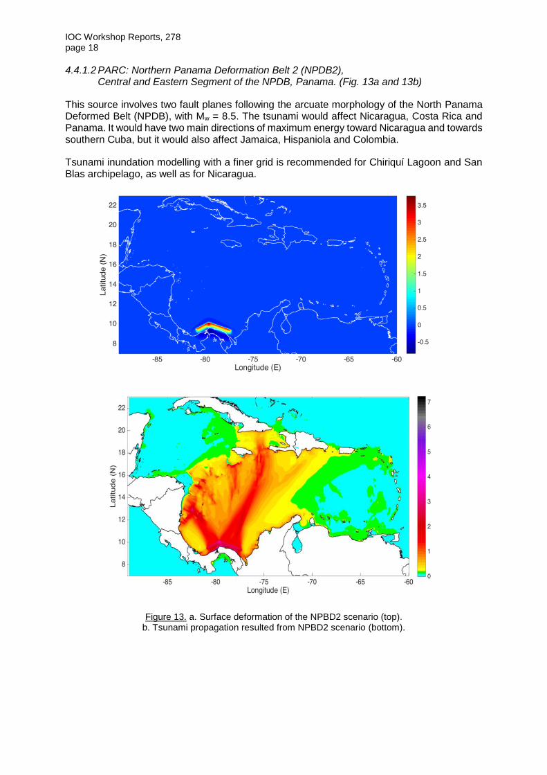
4.4.1.2 PARC: Northern Panama Deformation Belt 2 (NPDB2), Central and Eastern Segment of the NPDB, Panama. (Fig. 13a and 13b)
This source involves two fault planes following the arcuate morphology of the North Panama Deformed Belt (NPDB), with Mw = 8.5. The tsunami would affect Nicaragua, Costa Rica and Panama. It would have two main directions of maximum energy toward Nicaragua and towards southern Cuba, but it would also affect Jamaica, Hispaniola and Colombia.
Tsunami inundation modelling with a finer grid is recommended for Chiriquí Lagoon and San Blas archipelago, as well as for Nicaragua.
Figure 13. a. Surface deformation of the NPBD2 scenario (top). b. Tsunami propagation resulted from NPBD2 scenario (bottom).

IOC Workshop Reports, 278 page 19
4.4.1.3 Panama: Northern Panama Deformation Belt (NPDB3), Eastern NPDB segment, Panama. (Fig. 14a and 14b)
This source, also with Mw = 8.5, is located in the same region as the eastern segment of the 1882 source but offshore, and aligned with the front of the NPDB. This source was based on several data, among them GPS velocity vectors from published literature and predicted motion at the NPDB trace, with an angular vector clearly suggesting left-lateral strike-slip motion along the western segment and pure thrust along the Eastern one (A. López, personal communication).
The tsunami would affect Panama and Nicaragua, and as well as Colombia. Tsunami inundation modelling with a finer grid is recommended for San Blas archipelago and Nicaragua.
Figure 14. a. Surface deformation of the NPBD3 scenario (top). b. Tsunami propagation resulted from NPBD3 scenario (bottom).

IOC Workshop Reports, 278 page 20
4.4.2 CARIBBEAN REGIONAL SOURCES
4.4.2.1 WSCDB: Western segment- Southern Caribbean Deformation Belt. (Fig. 15a and 15b)
This source is not a local source for Central America, but was considered here due to proximity and directivity. It involves rupture of the western segment of the South Caribbean Deformed Belt (SCDB) offshore north Colombia, with Mw = 8.6.
The tsunami would affect mostly Nicaragua, and in a smaller extent Costa Rica and Panama, and its travel time would be about one hour for the nearest shores.
Tsunami inundation modelling with a finer grid is recommended for San Blas archipelago and Nicaragua.
Figure 15. a. Surface deformation of the WSCDB scenario (top). b. Tsunami propagation resulted from WSCDB scenario (bottom).

IOC Workshop Reports, 278 page 21
4.4.2.2 FSCDB: Full rupture along Southern Caribbean Deformation Belt. (Fig. 16a and 16b)
This source is not a local source for Central America, but was considered here due to its proximity and probable directivity. It represents the full rupture of the South Caribbean Deformed Belt (SCDB) offshore Colombia and Venezuela, with Mw = 8.8. This source was proposed at the Experts Meeting on Sources of tsunamis in the Caribbean with possibility to impact the southern coast of the Dominican Republic, Santo Domingo, Dominican Republic, 6–7 May 2016. Details can be found in the Meeting Report.
This source would affect mostly the Greater Antilles and Colombia and Venezuela. The consequences for Central America would be comparable to those of the source WSCDB.
Figure 16. a. Surface deformation of the FSCDB scenario (top).
b. Tsunami propagation resulted from FSCDB scenario (bottom).

IOC Workshop Reports, 278 Annex I
ANNEX I
AGENDA
DAY 1
14.00 Opening
14.15 PM Historical events in the Central America region and adjacent areas [Moderator:Bernardo Aliaga]
14.15–14.45 Wilfried Strauch Historical background: Central America Pacific Coast earthquakes and tsunamis
14.45–15.15 Emile Okal, Tsunami Earthquakes: the ultimate challenge in real-time tsunami mitigation
15.15–15.30 Pause
15.30–16.00 Thorne Lay, Modeling Tsunami Earthquakes and Slip to the Trench in Great Events
16.00–16.30 Hans Jürgen Meyer & Diana Mendoza, Possible evidence of prehistoric tsunami impact on San Andrés Island, Colombia and Preliminary evaluation of tsunami potential on the northern segment of the Colombian subduction zone (presented by D. Mendoza)
16.30–17.00 Emile Okal, Tsunami earthquakes, Landslides and Terraces: the contribution of rogue events to tsunami risk in Central America
DAY 2
8.30 Seismic studies and potential tsunamigenic sources in the Central America region [Moderator: Dr. Emile Okal]
8.30–9.00 Jose Antonio Alvarez-Gomez, Tsunamigenic sources in the Middle America Trench off Central America
9.00–9.30 Eduardo Camacho, Seismotectonics and Tsunamis in the North Panama Deformed Belt
9.30–10.00 Marino Protti, South Central America sources (presented by S. Chacón)
10.00 Technical/Scientific development of tsunami modelling for the Central America region, including key parameters [Moderator: Dr. Vasily Titov]
10.00–10.15 Vasily Titov, Tsunami model forecast approaches
10.15–10.30 Pause
10.30–10.45 Nestor Luque, Tsunami modeling of the September 7, 1882 tsunami in the Province of Colon, Panama.

IOC Workshop Reports, 278 Annex I – page 2
10.45–11.00 Silvia Chacon, Modeling of local tsunami sources for Costa Rica, Pacific and Caribbean shores
11.00–11.15 Natalia Zamora, Major challenges of the probabilistic tsunami hazard assessment along Central America
11.15 Break-out Groups
Round-up of the three sessions and general guidance discussion chaired by moderators [Bernardo Aliaga, Emile Okal, Vasily Titov]. Then separate groups would discuss the two objectives below.
1. Earthquake based scenarios – key parameters and geometry of the faults
2. Tsunami modelling – datasets inventory for topography and bathymetry, priority gaps
12.30–14.00 Lunch break
14.00–15.00 Break-out Groups – continued
15.00 Summary session – breakout groups report and recommendations
16.30 Close of the meeting

IOC Workshop Reports, 278 Annex II
ANNEX II
FAULT PLANE DATA
Pacific Side
REGION MAT
NAME GUANICA
Hypocenter Lon 13,8
Hypocenter Lat 268
Hypocenter Depth 20
EQ Mw 8,62
Shear modulus (GPa) 35
Seismic moment (N*m) 1,08E+22
Corner Point A segment 1 segment 2 segment 3
Lat 13,13 12,17 10,55
Lon 269,87 272,05 274,19
-90,13 -87,94 -85,81
Depth (km) 20 20 20
Corner Point B (NEOWAVE)
Lat 12,47 11,51 9,98
Lon 269,58 271,75 273,74
-90,42 -88,24 -86,26
Depth (km) 5 5 5
Corner Point C
Lat 13,3 12,47 11,51
Lon 267,6 269,6 271,75
-92,4 -90,42 -88,24
Depth (km) 5 5 5
Corner Point D Lat 13,96 13,13 12,08
Lon 267,89 269,88 272,21
-92,11 -90,11 -87,79
Depth (km) 20 20 20
Deep Center (MOST) Lat 13,54 12,64 11,31
Lon 268,88 270,96 273,19
-91,12 -89,03 -86,81 Depth (km) 20 20 20 Other Fault Parameters
Strike (phi) 293 294 308
Dip (delta) 20 20 20
Rake (lamda) 90 90 102
L (km) 234 259 276
W (km) 80 80 80
W map view (km) 75,2 75,2 75,2
Slip (m) 5 5 5
Seismic moment (N*m) 3,28E+21 3,63E+21 3,86E+21
Mw 8,28 8,31 8,33

IOC Workshop Reports, 278 Annex II – page 2
REGION MAT
NAME NICOBANO
Hypocenter Lon -86,26
Hypocenter Lat 9,98
Hypocenter Depth 2
EQ Mw 8,05
Shear modulus (GPa) 35
Seismic moment (N*m) 1,46E+21
Corner Point A segment 1 segment 2
Lat 9,25 9,48
Lon 275,27 275,47
-84,73 -84,53
Depth (km) 20 35
Corner Point B (NEOWAVE)
Lat 8,91 9,25
Lon 274,98 275,27
-85,02 -84,73
Depth (km) 10 20
Corner Point C
Lat 9,97 10,31
Lon 273,74 274,03
-86,26 -85,97
Depth (km) 10 20
Corner Point D
Lat 10,31 10,54
Lon 274,03 274,23
-85,97 -85,77
Depth (km) 20 35
Deep Center (MOST)
Lat 9,78 10,01
Lon 274,65 274,85
-85,35 -85,15
Depth (km) 20 35
Other Fault Parameters
Strike (phi) 311 311
Dip (delta) 12 29
Rake (lamda) 90 90
L (km) 180 180
W (km) 49 34
W map view (km) 47,9 29,7
Slip (m) 2,8 2,8
Seismic moment (N*m) 8,64E+20 6,00E+20
Mw 7,89 7,79

IOC Workshop Reports, 278 Annex II – page 3
REGION MAT
NAME OSA
Hypocenter Lon
Hypocenter Lat
Hypocenter Depth
EQ Mw 7,63
Shear modulus (GPa) 30
Seismic moment (N*m) 3,51E+20
segment 1 segment 2 segment 3
Corner Point A
Lat 8,51 8,34 8,18
Lon 276,87 277,08 277,26
-83,13 -82,92 -82,74
Depth (km) 6,5 6,5 6,5
Corner Point B (NEOWAVE)
Lat 8,17 7,99 7,84
Lon 276,57 276,78 276,96
-83,43 -83,22 -83,04
Depth (km) 2 2 2
Corner Point C
Lat 8,53 8,17 7,99
Lon 276,16 276,57 276,78
-83,84 -83,43 -83,22
Depth (km) 2 2 2
Corner Point D
Lat 8,87 8,51 8,34
Lon 276,46 276,87 277,08
-83,54 -83,13 -82,92
Depth (km) 6,5 6,5 6,5
Deep Center (MOST)
Lat 8,69 8,42 8,26
Lon 276,66 276,97 277,17
-83,33 -83,02 -82,83
Depth (km) 6,5 6,5 6,5
Other Fault Parameters
Strike (phi) 311 311 311
Dip (delta) 5 5 5
Rake (lamda) 90 90 90
L (km) 60 30 27
W (km) 50 50 50
W map view (km) 49,8 49,8 49,8
Slip (m) 2 2 2
Seismic moment (N*m) 1,80E+20 9,00E+19 8,10E+19
Mw 7,44 7,24 7,21

IOC Workshop Reports, 278 Annex II – page 4
NAME COLEC
Hypocenter Lon -79,39
Hypocenter Lat 1,47
Hypocenter Depth 22
EQ Mw 8,66
Shear modulus (GPa) 30
Seismic moment (N*m) 1,22E+22
Corner Point A segment 1
Lat -1,28
Lon 279,68
-80,32
Depth (km) 22
Corner Point B (NEOWAVE)
Lat -0,89
Lon 278,87
-81,13
Depth (km) 2
Corner Point C
Lat 4,23
Lon 281,55
-78,45
Depth (km) 2
Corner Point D
Lat 3,68
Lon 282,51
-77,49
Depth (km) 22
Deep Center (MOST)
Lat 1,47
Lon 280,61
-79,39
Depth (km) 22
Other Fault Parameters YeEtAl & JA-G
Strike (phi) 32
Dip (delta) 20
Rake (lamda) 90
L (km) 650
W (km) 125
W map view (km) 117,5
Slip (m) 5
Seismic moment (N*m) 1,22E+22
Mw 8,66

IOC Workshop Reports, 278 Annex II – page 5
REGION NPDB
NAME LIMON
Hypocenter Lon -82,54
Hypocenter Lat 9,37
Hypocenter Depth 19
EQ Mw 7,93
Shear modulus (GPa) 35
Seismic moment (N*m) 9,92E+20
Corner Point A segment 1
Lat 9,73
Lon 276,88
-83,12
Depth (km) 25
Corner Point B (NEOWAVE)
Lat 10,05
Lon 277,08
-82,92
Depth (km) 5
Corner Point C
Lat 9,33
Lon 278,25
-81,75
Depth (km) 5
Corner Point D
Lat 9,02
Lon 278,04
-81,96
Depth (km) 25
Deep Center (MOST)
Lat 9,37
Lon 277.46
-82,54
Depth (km)
Other Fault Parameters
Strike (phi) 122
Dip (delta) 25
Rake (lamda) 90
L (km) 150
W (km) 45
W map view (km) 40,8
Slip (m) 4,2
Seismic moment (N*m) 9,92E+20
Mw 7,93

IOC Workshop Reports, 278 Annex II – page 6
Caribbean Side
REGION NPDB
NAME PAN
Hypocenter Lon -77,75
Hypocenter Lat 9,8
Hypocenter Depth 25
EQ Mw 8,47
Shear modulus (GPa) 33
Seismic moment (N*m) 6,42E+21
Corner Point A segment 1
Lat 10,49
Lon 281,35
-78,65
Depth (km) 50,7
Corner Point B (NEOWAVE)
Lat 10,83
Lon 281,79
-78,21
Depth (km) 0
Corner Point C
Lat 9,11
Lon 283,15
-76,84
Depth (km) 0
Corner Point D
Lat 8,77
Lon 282,71
-77,29
Depth 50,7
Deep Center (MOST)
Lat 9,63
Lon 282,03
-77,9707
Depth(km)
Other Fault Parameters
Strike (phi) 142
Dip (delta) 40
Rake (lamda) 90
L (km) 243
W (km) 80
W map view (km) 61,3
Slip (m) 10
Seismic moment (N*m) 6,42E+21
Mw 8,47

IOC Workshop Reports, 278 Annex II – page 7
REGION NPDB
NAME 1882
Hypocenter Lon -79,64
Hypocenter Lat 10,16
Hypocenter Depth 25
EQ Mw 8,48
Shear modulus (GPa) 35
Seismic moment (N*m) 6,47E+21
Corner Point A segment 1 segment 2
Lat 9,64 8,98
Lon 280,18 279,26
-79,82 -80,74
Depth (km) 40 40
Corner Point B (NEOWAVE)
Lat 10,16 9,48
Lon 280,36 279,01
-79,64 -80,99
Depth (km) 5 5
Corner Point C
Lat 9,35 10,16
Lon 282,72 280,36
-77,28 -79,64
Depth 5 5
Corner Point D
Lat 8,83 9,67
Lon 282,54 280,61
-77,46 -79,39
Depth (km) 40 40
Deep Center (MOST)
Lat 9,25 9,32
Lon
-78,64 -80,07
Depth (km)
Other Fault Parameters
Strike (phi) 109 63
Dip (delta) 30 30
Rake (lamda) 110 65
L (km) 274 166
W (km) 70 70
W map view (km) 60,6 60,6
Slip (m) 6 6
Seismic moment (N*m) 4,03E+21 2,44E+21
Mw 8,34 8,19

IOC Workshop Reports, 278 Annex II – page 8
REGION SCDB
NAME WSCDB
Hypocenter Lon -73,7
Hypocenter Lat 12,3
Hypocenter Depth 25
EQ Mw 8,63
Shear modulus (GPa) 33
Seismic moment (N*m) 1,10E+22
Corner Point A segment 1
Lat 10,64
Lon 365
5
Depth (km) 38,2
Corner Point B (NEOWAVE)
Lat 11,26
Lon 284,22
-75,78
Depth (km) 11,8
Corner Point C
Lat 13,96
Lon 287,90
-72,10
Depth (km) 11,8
Corner Point D
Lat 13,34
Lon 288,38
-71,62
Depth (km) 38,2
Deep Center (MOST)
Lat 11,98
Lon 286,53
-73,46
Depth (km) 38,2
Other Fault Parameters
Strike (phi) 53
Dip (delta) 17
Rake (lamda) 90
L (km) 500
W (km) 90
W map view (km) 86,1
Slip (m) 7,4
Seismic moment (N*m) 1,10E+22
Mw 8,63

IOC Workshop Reports, 278 Annex II – page 9
REGION SCDB
NAME FullSCDB
Hypocenter Lon
Hypocenter Lat
Hypocenter Depth 25
EQ Mw 8,84
Shear modulus (GPa) 33
Seismic moment (N*m) 2,26E+22
Corner Point A segment 1 segment 2
Lat 10,64 12,96
Lon 284,70 287,91
-75,30 -72,09
Depth (km) 38,2 35,4
Corner Point B (NEOWAVE)
Lat 11,26 13,76
Lon 284,22 287,99
-75,78 -72,00
Depth (km) 11,8 4,6
Corner Point C
Lat 13,60 13,19
Lon 287,40 293,05
-72,59 -66,95
Depth (km) 11,8 4,6
Corner Point D
Lat 12,96 12,39
Lon 287,91 292,94
-72,09 -67,06
Depth (km) 38,2 35,4
Deep Center (MOST)
Lat 11,81 12,73
Lon 286,29 290,43
-73,71 -69,57
Depth (km) 38,2 35,4
Other Fault Parameters
Strike (phi) 53 96
Dip (delta) 17 20
Rake (lamda) 90 90
L (km) 434 550
W (km) 90 90
W map view (km) 86,1 84,6
Slip (m) 7,4 8
Seismic moment (N*m) 9,54E+21 1,31E+22
Mw 8,59 8,68


IOC Workshop Reports, 278 Annex III
ANNEX III
BIBLIOGRAPHY AND REFERENCES
Adamek, S., Frohlich, C. and Pennington, W.D. 1988. Seismicity of the Caribbean-Nazca Boundary: Constraints on microplate tectonics of the Panama region. Journal of Geophysical Research, Solid Earth, Vol. 93, Issue B3, pp. 2053–2075. (doi: 10.1029/JB093iB03p02053)
Álvarez-Gómez, J.A., Meijer, P.T., Martínez-Díaz, J.J. and Capote, R. 2008. Constraints from finite element modeling on the active tectonics of northern Central America and the Middle America Trench. Tectonics, Vol. 27, Issue 1. (doi:10.1029/2007TC002162)
Arroyo, I.G., Grevemeyer, I., Ranero, C.R. and VonHuene, R. 2014. Interplate seismicity at the CRISP drilling site: The 2002 Mw = 6.4 Osa Earthquake at the southeastern end of the Middle America Trench. Geochemistry, Geophysics, Geosystems, Vol. 15, Issue 7 pp. 3035–3050. (https://doi.org/10.1002/2014GC005359)
Audet, P. and Schwartz, S. 2013. Hydrologic control of forearc strength and seismicity in the Costa Rican subduction zone. Nature and Geoscience, Vol. 6, pp. 852–855.
Barckhausen, U., Roeser, H.A. and von Huene, R. 1998. Magnetic signature of upper plate structures and subducting seamounts at the convergent margin off Costa Rica. Journal of Geophysical Research, Vol. 103, Issue B4, pp. 7079–7093. (https://doi.org/10.1029/98JB00163)
Bilek, S.L. 2009. Seismicity along the South American subduction zone: Review of large earthquakes, tsunamis, and subduction zone complexity. Tectonophysics, Vol. 495, Issues 1–2, pp. 2–14. (doi:10.1016/j.tecto.2009.02.037)
Bilek, S.L. and Lay, T. 2002. Tsunami earthquakes possibly widespread manifestations of frictional conditional stability. Geophysical Research Letters, Vol. 29, Issue 14, pp. 1–4. (https://doi.org/10.1029/2002GL015215)
Bilek, S.L., Schwartz, S.Y. and DeShon, H.R. 2003. Control of seafloor roughness on earthquake rupture behavior. Geology, Vol. 31, No. 5, pp. 455–458. (doi:10.1130/0091-7613(2003)031<0455:COSROE>2.0.CO;2)
Borrero, J.C., Kalligeris, N., Lynett, P.J., Fritz, H.M., Newman, A. V, and Convers, J. A. 2014. Observations and Modeling of the August 27, 2012 Earthquake and Tsunami affecting El Salvador and Nicaragua. Pure and Applied Geophysics, Vol. 171, Issue 12, pp. 3421–3435. (doi:10.1007/s00024-014-0782-2)
Camacho, E., Hutton, W. and Pacheco, J.F. 2010. A New Look at Evidence for a Wadati–Benioff Zone and Active Convergence at the North Panama Deformed Belt. Bulletin of Seismological Society of America, Vol. 100, No 1, pp. 343–348. (doi:10.1785/0120090204)
Camacho, E. and Víquez, V. 1993. Historical seismicity of the North Panama Deformed Belt. Revista Geológica de América Central, No. 15, pp. 49–64. (DOI: 10.15517/rgac.v0i15.13238)
Collot, J.-Y., Charvis, P., Gutscher, M.-A. and Operto, S. 2002. Exploring the Ecuador-Colombia Active Margin and Interplate Seismogenic Zone. Eos, Transactions. American Geophysical Union, Vol. 83, Issue 17, pp. 185–190. (doi:10.1029/2002EO000120)

IOC Workshop Reports, 278 Annex III – page 2
Correa-Mora, F., DeMets, C., Alvarado, D., Turner, H.L., Mattioli, G., Hernandez, D., Pullinger, C., Rodriguez, M. and Tenorio, C. 2009. GPS-derived coupling estimates for the Central America subduction zone and volcanic arc faults: El Salvador, Honduras and Nicaragua. Geophysical Journal International, Vol. 179, Issue 3, pp. 1279–1291. (doi:10.1111/j.1365-246X.2009.04371.x)
de Boer, J.Z., Defant, M.J., Stewart, R.H., Restrepo, J.F., Clark, L.F. and Ramirez, A.H. 1988. Quaternary calc-alkaline volcanism in western Panama: Regional variation and implication for the plate tectonic framework. Journal of South American Earth Sciences, Vol.1, Issue 3, pp. 275–293. (doi:10.1016/0895-9811(88)90006-5)
de Boer, J.Z., Drummond, M.S., Bordelon, M.J., Defant, M.J., Bellon, H. and Maury, R.C. 1995. Cenozoic magmatic phases of the Costa Rican island arc (Cordillera de Talamanca). Geological Society of America. Special Papers, Vol. 295, pp. 35–56. (doi:10.1130/SPE295-p35)
DeMets, C., Gordon, R.G. and Argus, D.F. 2010. Geologically current plate motions. Geophysical Journal International, Vol. 181, Issue 1, pp. 1–80. (doi:10.1111/j.1365-246X.2009.04491.x)
Denyer, P., Arias, O. and Personius, S. 1995. Efecto tectónico del terremoto de Limón. Revista Geológica de América Central (doi:http://dx.doi.org/10.15517/rgac.v0i0.13394).
Dzierma, Y., Rabbel, W., Thorwart, M.M. and Mora, M.M. 2011. The steeply subducting edge of the Cocos Ridge: Evidence from receiver functions beneath the northern Talamanca Range, south-central Costa Rica. Geochemistry, Geophysics, Geosystems, Vol. 12, No. 4, pp. 1–25. (doi:10.1029/2010GC003477)
Feng, L., Newman, A. V., Protti, M., Gonzlez, V., Jiang, Y. and Dixon T.H. 2012. Active deformation near the Nicoya Peninsula, northwestern Costa Rica, between 1996 and 2010: Interseismic megathrust coupling. Journal of Geophysical Research. Solid Earth, Vol. 17, Issue B6. (doi:10.1029/2012JB009230)
Fernández, M., Molina, E., Havskov, J. and Atakan, K. 2000. Tsunamis and tsunami hazards in Central America. Natural Hazards, Vol. 22, Issue 2, pp. 91–116. (doi:10.1023/A:1008102600622)
Herd, D.G., Youd, T.L., Meyer, H., C., J.L.A., Person, W.J. and Mendoza, C. 1981. The Great Tumaco, Colombia Earthquake of 12 December 1979. Science, Vol. 211, No.4481, pp. 441–445. (doi: 10.1126/science.211.4481.441)
Hey, R. 1977. Tectonic evolution of the Cocos-Nazca spreading center. GSA Bulletin, Vol. 88, No. 10, pp. 1404–1420. (https://doi.org/10.1130/0016-7606(1977)88<1404:TEOTCS>2.0.CO;2)
Kanamori, H. 1972. Mechanism of tsunami earthquakes. Physics of the Earth and Planetary Interiors, Vol. 6, Issue 5, pp. 346–359. (doi:10.1016/0031-9201(72)90058-1)
Kanamori, H. and McNally, K. 1982. Variable rupture mode of the suduction zone along the Ecuador-Colombia coast. Bulletin of the Seismological Society of America, Vol 72, No 4, pp. 1241–1253.
Kikuchi, M. and Kanamori, H. 1995. Source characteristics of the 1992 Nicaragua tsunami earthquake inferred from teleseismic body waves. Pure and Applied Geophysics, Vol. 144, Issue 3–4, pp. 441–453. (doi:10.1007/BF00874377)

IOC Workshop Reports, 278 Annex II – page 3
Kobayashi, D., LaFemina, P., Geirsson, H., Chichaco, E., Abrego, A. a., Mora, H. and Camacho, E. 2014. Kinematics of the western Caribbean: Collision of the Cocos Ridge and upper plate deformation. Geochemistry, Geophysics, Geosystems, Vol. 15, Issue 5, pp. 1671–1683. (doi:10.1002/2014GC005234).
Kolarsky, R.A. and Mann, P. 1995. Structure and neotectonics of an oblique-subduction margin, southwestern Panama. Geological Society of America, Special Papers. Vol. 295, pp. 131–158. (doi:10.1130/SPE295-p131)
LaFemina, P., Dixon, T.H., Govers, R., Norabuena, E., Turner, H., Saballos, A., Mattioli, G., Protti, M. and Strauch, W. 2009. Fore-arc motion and Cocos Ridge collision in Central America. Geochemistry, Geophysics, Geosystems, Vol. 10, No. 5, pp. 1–21. (doi:10.1029/2008GC002181)
Lonsdale, P. and Klitgord, J.1978. Structure and tectonic history of the eastern Panama Basin. GSA Bulletin, Vol. 89, No. 7, pp. 981–999. (https://doi.org/10.1130/0016-7606(1978)89<981:SATHOT>2.0.CO;2)
Mann, P. 1999. Chapter 1 Caribbean sedimentary basins: classification and tectonic setting from jurassic to present, in: World, P.M.B.T.-S.B. of the (Ed.), Caribbean Basins. Elsevier, pp. 3–31. (doi:http://dx.doi.org/10.1016/S1874-5997(99)80035-5)
McIntosh, K.D., Silver, E.A., Ahmed, I., Berhorst, A., Ranero, C.R., Kelly, R.K. and Flueh, E.R. 2007. The Nicaragua Convergent Margin, in: Dixon, T., Moore, J. (Eds.), The Seismogenic Zone of Subduction Thrust Faults. Columbia University Press, New York, pp. 257–287.
Molina, E. 1997. Tsunami Catalogue for Central America 1539-1996. Reduction of natural disasters in Central America. (REPORT). University of Bergen Technical Report No. II 1-04.
Newman, A. V., Okal, E.A., 1998. Teleseismic estimates of radiated seismic energy: The E/M0 discriminant for tsunami earthquakes. Journal of Geophysical Research, Solid Earth, Vol. 103, Issue B11, pp. 26885–26898. (doi:10.1029/98JB02236)
NGDC/WDS. 2015. National Geophysical Data Center, World Data Service. Global Historical Tsunami Database. National Geophysical Data Center, NOAA. [WWW Document]. Access on 15.01.2015. URL http://www.ngdc.noaa.gov/hazard/tsu_db.shtml
Okal, E., 1992. Use of mantle magnitude Mm for reassessment of the moment of historical earthquakes1984. I: Shallow events. PAGEOPH, Vol. 139, No. 1, pp. 17–57.
Pacheco, J.F. and Sykes, L.R. 1992. Seismic Moment Catalog of Large Shallow Earthquakes, 1900 to 1989. Bulletin of the Seismological Society of America, Vol. 82, No. 3, pp. 1306–1349.
Plafker, G. and Ward, S.N. 1992. Backarc thrust faulting and tectonic uplift along the Caribbean Sea coast during the April 22, 1991 Costa Rica earthquake. Tectonics, Vol. 11, Issue 4, pp. 709–718. (https://doi.org/10.1029/92TC00609)
Protti, M., Güendel, F. and McNally, K. 1994. The geometry of the Wadati-Benioff zone under southern Central America and its tectonic significance: results from a high-resolution local seismographic network. Physics of The Earth and Planetary Interiors, Vol. 84, No. 1, pp. 271–287. (doi:10.1016/0031-9201(94)90046-9)

IOC Workshop Reports, 278 Annex III – page 4
Ryan, W.B.F., Carbotte, S.M., Coplan, J.O., O’Hara, S., Melkonian, A., Arko, R., Weissel, R.A., Ferrini, V., Goodwillie, A., Nitsche, F., Bonczkowski, J. and Zemsky, R. 2009. Global Multi-Resolution Topography synthesis. Geochemistry, Geophysics, Geosystems, Vol. 10, Issue 3. (doi:10.1029/2008GC002332)
Sak, P.B., Fisher, D.M., Gardner, T.W., Marshall, J.S. and LaFemina, P.C. 2009. Rough crust subduction, forearc kinematics, and Quaternary uplift rates, Costa Rican segment of the Middle American Trench. Geological Society of America Bulletin, Vol. 121, Issue 7–8, pp. 992–1012. (doi:10.1130/B26237.1)
Sallarès, V. 2003. Seismic structure of Cocos and Malpelo Volcanic Ridges and implications for hot spot-ridge interaction. Journal of Geophysical Research, Vol. 108, Issue B12, p.2564. (doi:10.1029/2003JB002431)
Satake, K. 1994. Mechanism of the 1992 Nicaragua Tsunami Earthquake. Geophys. Res. Lett. 21, 2519–2522. (doi:10.1029/94GL02338)
Satake, K., Bourgeois, J., Abe, K., Abe, K., Tsuji, Y., Imamura, F., Iio, Y., Katao, H., Noguera, E. and Estrada, F. 1993. Tsunami Field Survey of the 1992 Nicaragua Earthquake. Eos, Transactions, American Geophysical Union, Vol. 74, No. 13, pp. 145–160.
Silver, E.A., Reed, D.L., Tagudin, J.E. and Heil, D.J. 1990. Implications of the North and South Panama Thrust Belts for the origin of the Panama Orocline. Tectonics, Vol. 9, Issue 2, pp. 261–281. (doi:10.1029/TC009i002p00261)
Sitchler, J.C., Fisher, D.M., Gardner, T.W. and Protti, M. 2007. Constraints on inner forearc deformation from balanced cross sections, Fila Costeña thrust belt, Costa Rica. Tectonics, Vol. 26, Issue 6. (doi:10.1029/2006TC001949)
Swenson, J.L. and Beck, S.L. 1996. Historical 1942 Ecuador and 1942 Peru subduction earthquakes, and earthquake cycles along Colombia-Ecuador and Peru subduction segments. Pure and Applied Geophysics PAGEOPH, Vol. 146, Issue 1, pp. 67–101 (doi:10.1007/BF00876670)
Trenkamp, R., Kellogg, J.N., Freymueller, J.T., Mora, H.P. 2002. Wide plate margin deformation, southern Central America and northwestern South America, CASA GPS observations. Journal of South American Earth Sciences, Vol. 15, Issue 2, pp. 157–171. (https://doi.org/10.1016/S0895-9811(02)00018-4)
Von Huene, R. and Scholl, D.W. 1991. Observations at convergent margins concerning sediment subduction, subduction erosion, and the growth of continental crust. Reviews of Geophysics, Vol. 29, Issue 3, pp. 279–316. (https://doi.org/10.1029/91RG00969)
Wang, K. and Bilek, S.L. 2014. Fault creep caused by subduction of rough seafloor relief. Tectonophysics, Vol. 610, pp. 1–24. (doi:10.1016/j.tecto.2013.11.024)
Yamazaki Y., Cheung K.F. and Kowalik Z. 2010. Depth-integrated, non-hydrostatic modelwith grid nesting for tsunami generation, propagation, and run-up. International Journal for Numerical Methods in Fluids, Vol. 67, Issue 12, :2081–2107. (doi: 10.1002/fld.2485)
Ye, L., Lay, T. and Kanamori, H. 2013. Large earthquake rupture process variations on the Middle America megathrust. Earth and Planetary Science Letters, Vol. 381, pp. 147–155. (doi:10.1016/j.epsl.2013.08.042)

IOC Workshop Reports, 278 Annex IV
ANNEX IV
LIST OF PARTICIPANTS
Prof. Jose ÁLVAREZ GÓMEZ Lecturer Geodinámica Indian Ocean Rim Association (IORA) Secretariat IORA Secretariat Indian Ocean Rim Association 3rd Floor, Tower I, NeXTeracom Building, Cybercity, Ebene, Republic of Mauritius Ebene Mauritius Email: [email protected]
Dr Eduardo Isaias CAMACHO ASTIGARRABIA Director Instituto de Geociencias- Universidad de Panama Campus Central - COLINA Universidad de Panama Panama City, Panama Email: [email protected]
Dr Silvia CHACÓN BARRANTES Professor and Researcher Sistema Nacional de Monitoreo de Tsunamis (SINAMOT) Costa Rica Tel: +506 83096690 Fax: +506 22773616 Email: [email protected]
Mr Jose Jorge ESCOBAR Universidad Nacional Autonoma de Honduras Honduras Email: [email protected]
Mr Marco Antonio GIRALDO PNUD Dominican Republic Dominican Republic Email: [email protected]
Dr Victor HUERFANO Interim Director Puerto Rico Seismic Network Call Box 900 Mayaguez Puerto Rico 00681 United States Tel: 1+ 787 8338433 Fax: 1 787 2651684 Email: [email protected]
Mr Shusuke IRABU Experto Asesor del Proyecto BOSAI JICA BOSAI Proyecto de Desarrollo de Capacidades para la Gestion de Riesgo a Desastres en America Central Edificio de Gobernacion, 4to Nivel Centro de Gobierno San Salvador El Salvador Email: [email protected]
Mr Eiji KAWAHIGASHI Experto asesor/coordinador proyecto BOSAI JICA BOSAI Proyecto de Desarrollo de Capacidades para la Gestion de Riesgo a Desastres en America Central Edificio de Gobernacion, 4to Nivel Centro de Gobierno San Salvador El Salvador Tel: +503 2527 7141 Fax: +503 7914 9932 Email: [email protected]
Prof. Thorne LAY Distinguished Professor of Earth and Planetary Sciences University of California Santa Cruz, Earth and Planetary Sciences Department Earth and Marine Sciences Building 1156 High Street Santa Cruz CA 95064 United States Tel: +1 831 459 3164 Fax: +1 831 459 3074 Email: [email protected]
Dr Nestor LUQUE Investigador Instituto de Geociencias- Universidad de Panama Campus Central - COLINA Universidad de Panama Panama City Panama Email: [email protected]

IOC Workshop Reports, 278 Annex IV – page 2
Ms Griselda MARROQUIN Head of Seismology Environment and Natural Resources Ministry from El Salvador Kilómetro 5 1/2 carretera a Nueva San Salvador, Calle y Colonia las Mercedes San Salvador El Salvador Email: [email protected]
Ms Diana Patricia MENDOZA Research Assistant Corporación Observatorio Sismológico del Suroccidente - OSSO' Carrera 101 # 14 - 154 Ciudad Jardín A.A. 25928 Cali Valle del Cauca Colombia Email: [email protected]
Prof. Emile OKAL Dept. of Geological Sciences Northwestern University Evanston, IL 60208 USA United States Tel: +1-847-491-3238 Fax: +1-847-491-8060 Email: [email protected]
Dr Javier Francisco PACHECO Observatorio Vulcanologico y Sismologico de Costa Rica Apartado Postal: 2346-3000 Heredia Costa Rica Email: [email protected]
Dr Mark PETERSEN U.S. Geological Survey 1711 Illinois St. Golden Colorado CO 80401 United States Tel: +1 303-273-8546 Fax: +1 303-273-8600 Email: [email protected]
Dr Marino PROTTI Professor Costa Rica Volcanological and Seismological Observatory-Universidad Nacional Universidad Nacional Autonoma de Costa Rica Apartado 1718-3000 Heredia Heredia 3000
Costa Rica Tel: +1 506 2562-4001
Fax: +506 2261-0303 Email: [email protected] (Couldn’t attend in person, his contribution was presented by Dr. Silvia Chacon)
Lic Wilfredo ROJAS Scottish Environment Protection Agency, SEPA ASB Angus Smith Building Maxim 6 4 Parklands Avenue Eurocentral Holytown North Lanarkshire ML1 4WQ United Kingdom Email: [email protected]
Dr Wilfried STRAUCH Advisor on Earth Sciences Instituto Nicaragüense de Estudios Territoriales Frente a Hospital Solidaridad Managua 2110 Nicaragua Tel: +505 89 24 62 34 Email: [email protected]
Mr Emilio TALAVERA Director de Sismologia Instituto Nicaragüense de Estudios Territoriales Frente a Hospital Solidaridad Managua 2110 Nicaragua Tel: +505 22492761 ext 115 Fax: +505 22491082 Email: [email protected]
Dr Vasily TITOV Lead Scientist NOAA Center for Tsunami Research - Pacific Marine Environmental Laboratory 7600 Sand Point Way NE, Bldg 3 Seattle, Washington 98115 United States Tel: +1 (206) 526 4536 Email: [email protected]
Dr Christa VON HILLEBRANDT-ANDRADE Manager and Researcher NOAA NWS Caribbean Tsunami Warning Program Mayaguez

IOC Workshop Reports, 278 Annex IV – page 3
Puerto Rico 00680 United States Tel: +1-787-249-8307 Fax: +1-787-265-1684 Email: [email protected]
Dr Natalia ZAMORA SAUMA Consultant and Researcher Fundación Tropos APDO. 1309-2050 San José Costa Rica Email: [email protected]
Mr Bernardo ALIAGA Programme Specialist, Tsunami Unit Intergovernmental Oceanographic Commission of UNESCO 7 Place de Fontenoy 75732 Paris Cedex 07 France Tel: +33 1 45 68 39 80 Fax: +33 1 45 68 50 10 Email: [email protected]

IOC Workshop Reports, 278 Annex V
ANNEX V
LIST OF ACRONYMS
CA Caribbean plate
CAM Central America
CaR Carnegie Ridge
CATAC Central America Tsunami Advisory Centre
CNS Cocos-Nazca Spreading Center origin
CO Cocos plate
CoR Cocos ridge
ECHO European Commission's Civil Protection and Humanitarian Aid Operations department
EPR East Pacific Rise
FSCDB Full South Caribbean Deformed Belt
GaIs Galapagos Islands
GF Grijalva Fracture Zone
HeS Hess Escarpment
ICG/PTWS Intergovernmental Coordination Group for the Pacific Tsunami Warning and Mitigation System
INETER Nicaraguan Institute of Territorial Studies
IOC Intergovernmental Oceanographic Commission
MAT Middle America Trench
NAB Northern Andean Block
NAM North American plate
NAZ Nazca plate
NPDB North Panama Deformed Belt
PaB Panama Block
PFZ Panama Fracture Zone
PoM Polochic Motagua Fault Zone
RSB Rough-smooth ocean floor boundary

IOC Workshop Reports, 278 Annex V – page 2
SAM South American plate
SAT South American Trench
SCDB South Caribbean Deformed Belt
TEMPP Tsunami Evacuation Maps, Plans and Procedures
UNESCO United Nations Educational, Scientific and Cultural Organization
WG Working Group